Introduction
To [me], not only to [me] but to the hunters, you have to have an association with the sea ice. To [me] it's almost like a gift because you have to depend on the conditions of the ice, and depending on the conditions it will have an effect on how much you're able to bring in terms of food on the table. So, it has an effect on how you live as a person, as a hunter. Because once we notice that the conditions start to deteriorate at any particular spot, the hunter doesn't necessarily become totally helpless but he knows that he's going to have more difficulty in trying to procure the animals that he needs to survive on. So you have to have that association with the ice (Maniapik Reference Maniapik2004a).
This paper is the third in a series of three (Laidler and Elee Reference Laidler and Elee2008; Laidler and Ikummaq Reference Laidler and Ikummaq2008) that presents an initial attempt to document and communicate sea ice conditions and Inuktitut (Inuit language) terminology based on detailed local expertise in Inuit communities around Baffin Island, Nunavut. The first in this series, Laidler and Elee (Reference Laidler and Elee2008) presented the introductory background and rationale that underlies the conduct of sea ice research in all three communities (that is Cape Dorset, Igloolik, and Pangnirtung). In that paper we highlighted the historical and contemporary importance of sea ice in Inuit communities, and the long-term experience, use, and observation of sea ice that renders many Inuit elders and active hunters experts on local ice conditions and dynamic processes. This paper continues along the same lines, using a similar methodology, in order to contribute to systematic, community-specific documentation of Inuit knowledge of the sea ice environment. By undertaking this project in several different communities, we can increase our understanding of sea ice at local scales, in local contexts, and in relation to local culture, lifestyle, and socio-economics. In this paper, we present the results of research undertaken in Pangnirtung, Nunavut, from May 2004 to April 2005. Documenting Inuktitut terminology and explanations of local freeze-thaw processes, and the related influences of winds and currents on ice formation or movement, provides a unique glimpse of Inuit expertise on local-scale physical ice conditions and processes. As highlighted in Laidler and Elee (Reference Laidler and Elee2008), sea ice knowledge and terminology documentation is not new, but we wish to contribute to this literature by providing a detailed account for Pangnirtung. We also aim to continue moving beyond glossaries, by emphasising the interrelations between terminology, ice conditions, seasonal processes, and ice uses. Finally, as this paper concludes the series, we will provide a comparative synthesis of the three papers, along with an overview of the broader implications of results, to contribute to future collaborative science, education, and/or heritage initiatives.
Methods
Community
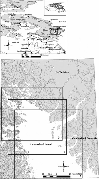
Pangnirtung is located on the southeastern shore of Pangnirtung Fiord (on Cumberland Peninsula) (66°7′N, 65°55′W), off the northern shore of Cumberland Sound (Fig. 1a). Cumberland Sound was visited by John Davis in 1585, and the land north of the sound was named Cumberland Island (later found to be a peninsula) by William Baffin in 1616 (Kemp Reference Kemp and Freeman1976). The community name of Pangnirtung is actually a poor spelling of the Inuktitut name Panniqtuuq (meaning ‘place of the bull caribou’) (Harper Reference Harper and Dewar2004). Cumberland Sound has been home to Inuit for over 1000 years, with seals, walrus, beluga whales, and bowhead whales frequenting the waters (Harper Reference Harper and Dewar2004). Since 1818, this area has been the focus of organised whaling activities (attracting Inuit and European whalers alike) (Kemp Reference Kemp and Freeman1976; Harper Reference Harper and Dewar2004). A Hudson Bay Company (HBC) trading post was opened in Pangnirtung in 1921, followed shortly by a detachment of the Royal Canadian Mounted Police (RCMP) (Kemp Reference Kemp and Freeman1976; Harper Reference Harper and Dewar2004). From the mid–1950s to early–1960s the federal government began establishing a schooling and administrative presence, encouraging families in outlying camps to move into the community (Harper Reference Harper and Dewar2004). Currently with a population of approximately 1325 (95% Inuit) (StatsCan 2006), Pangnirtung is known for its commercial turbot fishery (Pangnirtung Fisheries), the nearby National Park (Auyuittuq National Park), and its unique weaving artistry (based at the Uqqurmiut Centre for Arts and Crafts) (Harper Reference Harper and Dewar2004; Scott Reference Scott and Dewar2004).
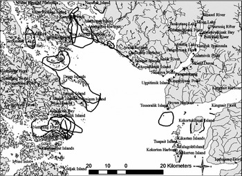
Study area maps, including: a) Map showing the location of Pangnirtung (Nunavut highlighted in grey in inset, and the square indicates the Baffin Island region shown in the larger map); b) Map sheets and extent used in interviews, with squares indicating the areas of interest portrayed as subsets throughout the paper (that is 1 = Fig. 7, mid-Cumberland Sound; 2 = Fig. 9, southern Cumberland Sound; 3 = Fig. 10, 14, northern Cumberland Sound).

Research approach
This project was undertaken with community members of Pangnirtung using a collaborative approach summarised in Laidler and Elee (Reference Laidler and Elee2008), and described in detail in Laidler (Reference Laidler2007). The research was initiated with a preliminary visit to Pangnirtung in September 2003 to: i) propose the project to community groups and organisations; ii) to discuss community interest in the project; iii) to jointly establish research priorities; iv) to answer questions or concerns; v) to assess project feasibility; and, vi) to determine appropriate field work timing and duration (as in Laidler and Elee Reference Laidler and Elee2008). Subsequently, several field research visits were planned according to community suggestions to return at various stages of sea ice freezing and decay (May and December 2004, and February and April 2005), making a total of nearly three months spent in the community. Only the methods specific to Pangnirtung are described here, with the more technical references already summarised in Laidler and Elee (Reference Laidler and Elee2008) and a detailed evaluation provided in Laidler (Reference Laidler2007).
Semi-directed interviews
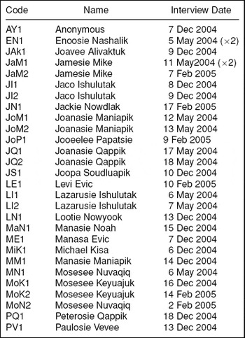
Inuit elders and hunters deemed to be the most knowledgeable about sea ice by community members and representatives (that is community organisations such as the Hunters and Trappers Association (HTA), the local elders’ group, interpreters, and other elders and hunters), were recommended as key informants in a purposeful sampling strategy. In total (over the four research trips), 30 semi-directed interviews (Huntington Reference Huntington2000; Bennett Reference Bennett and Shurmer-Smith2002; Esterberg Reference Esterberg2002) were conducted with 21 different people, all male (out of a recommended list of 30 people) (Table 1). General questions were asked about Inuktitut sea ice terminology, descriptions of freeze/thaw processes, and the influences of winds and currents on sea ice formation or movement, in order to spark discussions and explanations of related topics. All interviews were conducted by the first author, with the other authors interpreting or facilitating where the interviewee was most comfortable (or unilingual) in their native language of Inuktitut. Interviews were conducted in the homes of informants, the Hunters and Trappers Association (HTA) Board Room, a Nunavut Arctic College classroom, a Parks Canada meeting room, and the Hamlet Council chamber. Where consent was provided, interviews were recorded digitally with audio and/or video recorders. All originals (and transcripts) are stored at the Angmarlik Visitor Centre, to ensure community access to these materials.
Interview participants (sorted alphabetically by code to facilitate interviewee identification throughout the text).

Several National Topographic Service (NTS) map sheets at the 1:250000 scale (26G, H, I, J; see Figure 1b) were incorporated in interviews i) to facilitate knowledge-sharing; ii) to enhance explanations of sea ice conditions or uses; iii) to enable spatial delineation of key sea ice features, regional sea ice extent, or uses (for example hunting areas, travel routes); and, iv) to promote discussion or spark memories (Laidler Reference Laidler2007). Each interviewee had their own clear mylar (plastic) overlay upon which he could draw sea ice features with which he was most familiar or wanted to document. As highlighted in Laidler and Ikummaq (Reference Laidler and Ikummaq2008), the place-names shown in maps within this paper are those that appear on the NTS map sheets, and do not accurately reflect Inuktitut place-names (official revisions with accurate Inuktitut names are still being finalised).
Sea ice trips
As emphasised in Laidler and Elee (Reference Laidler and Elee2008), it was important that Laidler experience sea ice travel and/or hunting in order to begin to understand, and conceptualise, Inuit expertise of sea ice. Therefore, such participation was a priority wherever possible, and Laidler was fortunate to participate in five different sea ice trips (by snowmobile and on foot) to various locations around Pangnirtung (the floe edge, Pangnirtung Fiord, the northeastern end of Cumberland Sound, and fishing lakes), at least once during each of the research trips. These trips were guided by elders that had been interviewed, a local outfitter, and other community members.
Focus groups
Focus groups (Lindsay Reference Lindsay1997; Fox Reference Fox, Krupnik and Jolly2002) were employed to bring small groups of local experts together to help: i) link Inuktitut terminology for various ice conditions to pictures taken on sea ice trips; ii) develop and verify terminology links within a sequential order of sea ice formation/decay based on compiled interviews; and, iii) verify sea ice features drawn on maps (Laidler Reference Laidler2007). We conducted two focus groups in the third and fourth research trips (February and April 2005). These sessions were an important means of acquiring feedback and of helping to ensure the accuracy of results interpretation.
Data analysis and knowledge representation
Data analysis of Pangnirtung results was conducted in the same manner as that described in Laidler and Elee (Reference Laidler and Elee2008), using theme coding and qualitative analysis software to facilitate code compilation. The conceptual models presented in following sections attempt to highlight the relationships between each of the ice types/features/processes, based on Inuit expertise, to provide an overview of the human geographies of sea ice around Pangnirtung. As in Laidler and Elee (Reference Laidler and Elee2008), the following sections are based on what Inuit elders and hunters have shared with the authors, and they are formally referenced throughout the paper using a coding system to identify interviewees (Table 1). Similar efforts have also been made to provide interview quotes throughout, and to present as accurate and consistent a picture of local ice conditions as possible. Again, it is important to note that results cannot be static, and that dialectical differences also come into play in Pangnirtung, so terminology is not necessarily directly applicable beyond the community. As highlighted in Laidler and Ikummaq (Reference Laidler and Ikummaq2008), the refinement of Inuktitut spelling and meanings is a continuing process. The terminology presented here is a result of several iterations of work, but can by no means be considered a final or exhaustive list of terms related to sea ice conditions or use. As in the previous two papers, we have also incorporated Inuktitut sea ice terminology throughout the text, and have indicated the scientific sea ice terminology (according to World Meteorological Organization (WMO) standards, as summarized in Laidler (Reference Laidler2006a)) that most closely approximates the meaning of Inuktitut terms.
Freezing processes
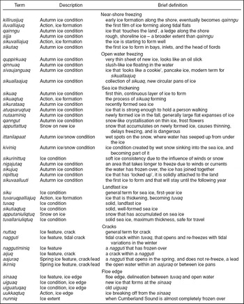
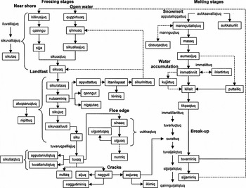
In this section, Table 2 and Fig. 2 should be consulted as references for Inuktitut terminology and links between processes.
Inuktitut terminology, descriptions, and brief definitions for sea ice conditions associated with freezing stages (in approximate order as shown in Figure 2).

Conceptual diagram of freeze-thaw processes, interactions, and terminology based on interviews conducted in Pangnirtung. Where: ———— = general process direction - - - - - - - = cyclical process direction.

Near-shore freezing
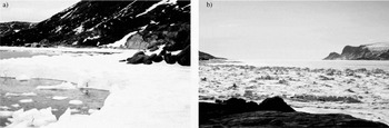
Ice begins forming at the edge of the land in the autumn (killirusijuq) (Fig. 2) (Nashalik Reference Nashalik2004 (EN1); Noah Reference Noah2004 (MaN1)). The process of the first ice beginning to form and extend over the tidal flats is referred to as iluvalliajuq (Fig. 2) (Ishulutak Reference Ishulutak2004a (LI1)). As this ice extends off the shoreline it becomes qainngu, and then sijja once it has solidified (which is often rough due to tidal variations) (Figs. 2, 3a, b) (LI1; MaN1).
Yeah, because what you call a pressure ridge, what we call sijja, and then you have the land, well this is the land and then you have the ice that's sitting between the pressure ridges and the land . . . that's what we call qainngu (Ishulutak Reference Ishulutak2004a).
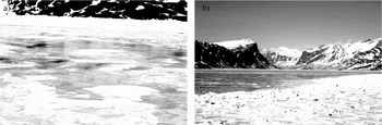
Photos of near-shore freezing conditions, including: a) spring qainngu, an ice ledge along the shore that supports sea ice travel, usually the first part to form and the last part to break off; and, b) sijja, rough shoreline ice created by tidal variations, shown here towards spring with flat landfast ice in the background.

When the ice begins forming outwards from the land the process is termed sikuvalliajuq, ‘the ice is starting to form well’ (Fig. 2) (Mike Reference Mike2004 (JaM1); Qappik Reference Qappik2004a (JQ1); Soudluapik Reference Soudluapik2004 (JS1); LI1; Evic Reference Evic2005 (LE1)). Small bays, inlets, and the heads of fiords tend to freeze over first (sikutaq) (Fig. 2) (JQ1; LE1; LI1; MaN1; Veevee 2004 (PV1)), or between islands where the ice can easily become landlocked (Evic Reference Evic2004 (ME1)). These areas of early freezing also tend to be where seals congregate in the autumn (LE1; LI1; MaN1; PV1).
Open water freezing
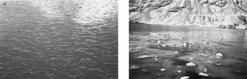
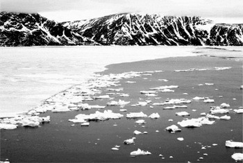
In open water, it is possible to see the first ice crystals forming in the water when a slight breeze highlights areas that look like oil slicks (quppirkuat, plural for quppirkuaq) (Fig. 2) (Qappik Reference Qappik2004c (PQ1)). The earliest formation of ice is a slush-like consistency in the water called qinnuaq (likened to frazil/grease ice), which can be caused by freezing or by snow falling in the open water (Figs. 2, 4a) (Anon. 2004 (AY1); JS1; Nowyook Reference Nowyook2004 (LN1); Papatsie Reference Papatsie2005 (JoP1); MaN1; Maniapik Reference Maniapik2004c (MM1); Keyuajuk Reference Keyuajuk2004 (MoK1); PQ1). As this flexible ice stiffens with colder temperatures, the ice will start to form (AY1). Where winds come off the land in bays and fiords, these cause newly formed ice to be blown around, forming sivaujanguaq (literally referring to what ‘looks like a cookie’, likened to pancake ice) (EN1).
And that first ice that forms at the edge of the land, whenever there's a wind that comes out of the land and into the middle of the bays and little fiords [I] call it cookie-like pieces of ice that come off the land. And if you get a lot of that then the whole ocean will freeze sooner if you have more of those cookie ice floating all over the place . . . And [I] call it sivaujanguaq [which is a very modern term for looking like a cookie] . . . Or looking like a biscuit, sivaujat (Nashalik Reference Nashalik2004).
Photos of open water freezing conditions, including: a) quinnuaq, early slush-like ice formation; and, b) sikuaq, the first continuous sheet of ice that forms in the fall.

However, the more traditional term for this kind of ice would be sikuallaajuq (likened to pancake ice), referring to multiple pans of sikuaq (see following section) in an area (Fig. 2) (PQ1). These circular formations can also be created by the influence of currents pushing ice into each other (EN1). If sikuallaajuq congregate in certain areas they can cause the ice to thicken sooner than if they were not present (EN1).
Sea ice thickening
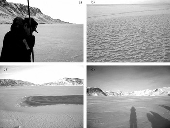
The first continuous sheet of ice is sikuaq (likened to nilas) (Figs. 2, 4b) (AY1; EN1; JaM1; MaN1; Kisa Reference Kisa2004 (MiK1); PQ1). This is a very thin, brittle type of ice that is just covering the ocean surface, whereby sikuaqtuq refers to the process of sikuaq forming (Fig. 2) (JaM1). Once the ice is thick enough to walk on (sikurataaq) it is considered atuqsaruqtuq (strong enough to hold a person, although it is only recommended to walk on this ice while continually testing its strength with a harpoon) (Fig. 2, 5a) (JaM1; Ishulutak Reference Ishulutak2004c (JI1); JoP1; LN1; MM1; MoK1). After the ice is about a week old, but before snow has fallen, it is called nutaaminiq (‘it used to be new’), and it would be possible to travel on this ice and hunt at seal breathing holes (alluit) (Fig. 2) (Maniapik Reference Maniapik2004a (JoM1); JoP1; MiK1; PV1). Sometimes qanngut (likened to frost flowers) will form on new ice, appearing to be snow crystals but actually they emerge from the sea ice due to the temperature difference between the ocean and the cold air (Figs. 2, 5b) (AY1; EN1; JaM1; LN1; PV1).
You know when the ice is first forming it looks like there is little snow crystals on top of it. But they're actually sea ice crystals . . . they look like snow but they're ice, on top of the new ice, whenever there is these little things on top of [the ice] it takes longer to become solid. When it's clear then it takes less time in order to become solid and than when that qanngut is the very top layer (Nashalik Reference Nashalik2004).
Photos of various stages of sea ice thickening, including: a) sikurataaq, ice thick enough to walk on, thus it is atuqsaruqtuq; b) qanngut, crystallized frost formations that form on thin ice, usually near open water; c) nigajutaq, an area where the ice takes longer to freeze; and, d) looking into Pangnirtung Fiord, standing on tuvaq.

In addition, where these crystalline formations occur the ice is not as slippery (Fig. 2) (EN1; MoK1). If snow falls on the newly forming ice it is referred to as apputtattuq (Fig. 2) (AY1; JoM1). This snow accumulation on thin ice will prevent thickening, and may even melt the sea ice causing dangerous thinning as well as wet spots where water has seeped up from underneath (ittanilapaat) (Fig. 2) (AY1; JoM1; JS1; MM1; MoK1). This delays the freezing progression but the snow can also sink into the ice, becoming part of it (kiviniq) and thus actually strengthen the ice (Fig. 2) (JoM1). However, usually snow accumulation will create areas that are softer than the surrounding sea ice (sikurinittuq) (Fig. 2) (Nuvaqiq Reference Nuvaqiq2004 (MoN1); JS1). Even as the ice thickens, some areas will take longer to freeze than others. Therefore, where winds and currents have delayed freezing they create nigajutait (plural for nigajutaq) (Fig. 2, 5c) (JaM1; MaN1).
When the ice cover becomes solid and continuous (sikujuq), it then progresses to be referred to as nipittuq (‘stuck to the land’) (Fig. 2) (JS1; PQ1). Once ice has formed that will last until the following year, it is referred to as sikuvaalluuti (Fig. 2) (EN1), which thickens further to become siku (general term for sea ice, likened to first-year ice) (Fig. 2) (AY1; JoP1; LI1; MaN1; MM1; MiK1). The process of tuvaruqpalliajuq means that the ice is getting thicker, in other words ‘tuvaq is forming’ (Fig. 2) (JI1; JQ1; LE1). Once the tuvaq has solidified, it is thick landfast ice (approximately 60 cm) (Fig. 2, 5d) (JoM1; JQ1; LE1; LI1; MaN1; MiK1; MoN1), and the ice is considered to have formed properly (sikutiaqtuq) (MM1). At this stage, snow can accumulate on the ice (apputaniuliqtuq) without causing thinning (Fig. 2) (JQ1). Once the sea ice reaches its maximum seasonal thickness, it is considered tuvallariuliqtuq and it is generally safe to travel anywhere (Fig. 2) (JQ1).
Tidal cracks
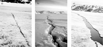
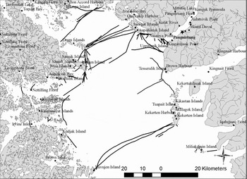
Any crack that forms, but does not widen, is termed nuttaq (Fig. 2, 6a) (JoM1; ME1; PQ1). A nagguti is a crack that has opened, usually due to tidal variations or lunar cycle, and then has refrozen (Figs. 2, 6b) (AY1; EN1; JaM1; Mike Reference Mike2005 (JaM2); Ishulutak Reference Ishulutak2004d (JI2); JoM1; JoP1; JS1; LI1; LN1; MaN1; ME1; MiK1; MM1; MoK1; PQ1; PV1). Naggutiit (plural for nagguti) tend to occur in the same place every year, usually between points of land (AY1; EN1; JaM1; JaM2; JoP1; LI1; LN1; MiK1; MoK1) or in shallower areas where there is more ice movement (Fig. 7) (JaM2; JoP1; MM1). A crack that does not re-open later in the winter is referred to as a naggutiminiq, ‘it used to be a nagguti’ (Fig. 2) (JaM1; LI1). Whereas, a smaller crack within a nagguti is an aijuq (Fig. 2) (LI1; Nowdlak Reference Nowdlak2005 (JN1)). In the spring, when there is open water in a nagguti it is then called an aajuraq (likened to a lead) (Fig. 2, 6c) (AY1; EN1; JaM1; JaM2; JoP1; JS1; LI1; MaN1; MiK1; PQ1). Sometimes a series of naggutiit will become a large aajuraq in the spring (MaN1), whereby the area of open water within the crack is termed ikirniq (ME1; JoP1).
Photos of different types of tidal cracks, including: a) nuttaq, a small crack in the ice that does not widen; b) nagguti, a crack that opens and re-freezes several times during the winter; and, c) aajuraq, a nagguti that opens in the spring and does not re-freeze.

The location of various naggutiit in Cumberland Sound. Sources: AY1; EN1; JaM1; JN1; JoP1; Qappik Reference Qappik2004b (JQ2); JS1; LN1; MaN1; ME1; MM1; PQ1; PV1.

Floe edge
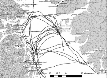
The edge of the tuvaq is called the sinaaq (likened to the floe edge) (Fig. 2, 8) (JaM2; LE1; LN1; MaN1; MM1), and this can vary in position from year to year (Fig. 9). Any new ice that forms along the sinaaq is referred to as uiguaq, literally ‘an addition’ (Fig. 2) (EN1; JaM1; ME1; MM1). This new ice tends to be thin and smooth due to the fact that it is continually adding onto the sinaaq (JaM1; ME1). Therefore, the older uiguaq is referred to as uiguatuqaq, while the newest ice at the sinaaq is always uiguaq (Fig. 2) (ME1).
Uiguaq, that's the term. Like if this is the sinaaq, and then this little area will freeze all along the edge, uiguaq. And then a couple days later there will be another new uiguaq out here, and this keeps getting bigger and bigger like that. So this is solid ice, this is the new ice, so this whole area would be uiguaq [drawing] . . . The first one that forms it's called an uiguaq at first. But then when a new uiguaq forms there, this old one is called uiguatuqaq, meaning an old uiguaq. Uiguaq just means an addition, so this would be like the new uiguaq, that's the old uiguaq (Evic Reference Evic2004).
Spring sinaaq at the mouth of Pangnirtung Fiord in May 2004.

Variations in the position of the sinaaq in Cumberland Sound. Sources: JAk1; JI1; JoM2; JoP1; LE1; MM1; MoN1; PV1.

If some of the tuvaq breaks off at the sinaaq the action is termed uukkaqtuq (Fig. 2) (ME1). Furthermore, nunniq is a specialised term used to refer to the extent of freezing in Cumberland Sound, typically when the sinaaq is located three quarters of the way (or more) to the mouth of the sound (Fig. 2) (AY1; JI1; Maniapik Reference Maniapik2004b (JoM2); LN1; MaN1; ME1; MM1; PQ1). However, this condition does not occur every year (AY1; JI1; JoM2; LN1; MaN1; PQ1), and has been occurring less frequently in recent times (AY1; JoM2; MaN1; PQ1).
Melting processes
In this section, Table 3 and Fig. 2 should be consulted as references for Inuktitut terminology and links between processes.
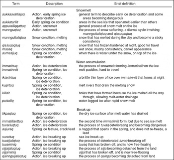
Inuktitut terminology, descriptions, and brief definitions for sea ice conditions associated with melting stages (in approximate order as shown in Fig. 2).

Snowmelt
In Cumberland Sound the ice begins to melt, and can become dangerous in certain areas as early as March, a process referred to as aukkaavalliajuq (JN1; JoM1; JS1) (Fig. 2). Therefore, the ice can be melting and eroding from underneath, due to the movement and influence of the currents, before the snow is even melting on top (AY1; JN1; JoM1; JQ1; LI2; ME1). This can cause some areas to open earlier than others (aukkaturliit) (Figs. 2, 10) (JoM1; JoP1; LI2; MaN1; Nuvaqiq, Reference Nuvaqiq2005 (MoN2)). In general, the earliest melt stages are visually evident through indicators of snow melting on top of the ice (apputailiqqattuq) (Fig. 2) (PQ1). The snow will become soft (mannguqtuq) (JQ1; MaN1; MM1), to a consistency where it is possible to make snowballs (mannguttaliqtuq) (Fig. 2) (AY1; ME1; MM1). For a short period of time the process of mannguqtuq occurs in a diurnal cycle whereby snow is mannguttaliqtuq during the day, but at night when the temperature drops it is qissuqaqtuq (Fig. 2) (ME1; MaN1).
And that same snow that you call mannguttaliqtuq during the day time, at night time when it gets cold qissuqaqtuq is the term for snow that has frozen again . . . That's really ideal for traveling in the spring time. Like during the daytime it'll be really soft and you'll go right through it, but at night time you go right on top of it and you can travel anywhere, after it has frozen again (Evic Reference Evic2004).
Map showing the location of various aukkaturliit, areas within the sea ice that open up earlier than others in the spring. Sources: JaM1; JoM2; JoP1; JQ2; LE1; LI2; MaN1; MiK1; MoK1; MoN1.

As the snow melts further there can be dark spots (masaq) in the snow where it is wet (Fig. 2) (JN1). Water then accumulates under the snow, but still on top of the ice (aumasijuq) (Fig. 2) (LN1). At this point, the ice is becoming dangerous (MiK1).
Water accumulation and drainage
The process of immatittuq forms puddles of water on top of the ice (immatinniit), due to snowmelt (Fig. 2) (AY1; EN1; JoM1; JQ1; JS1; MaN1; ME1; MiK1; PQ1; PV1).
Ok what happens is that when the sea ice becomes immatinniq, that's the result of the snow that's on top of the [ice] that's melted, it has become slush. In the early part of spring it gets really slushy out there, and people get stuck in the water, we call it water, imaq . . . it gets so wet out there that it becomes slushy water, and that's the result of the snow melting (Qappik Reference Qappik2004a).
This water will accumulate before it starts draining off into aajurait and alluit (AY1; EN1; JoM1). The very top film of these puddles will sometimes re-freeze at night (ikiartirtuq), but water or air will remain underneath (Figs. 2, 11a) (MaN1; ME1; MoN1). The melt-water will then collect into little melt rivers (kujjirtuq) (MaN1), and where the ice has melted all the way through they will drain into killait (likened to melt holes) (Fig. 2) (EN1; JaM1; ME1; PQ1).
And then in May, June, the ice conditions deteriorate to the point where at this time you can see there's water spots on the ice right now, and you know there's water. But there's certain spots that, along these water puddles on the ice, some of them do have small spots of open water that goes right into the sea. And some are really thin where people should be careful about traveling through those because a snowmobile can literally go through these spots. And that is what we call killaq (Mike Reference Mike2004).
Photos of water accumulation on the sea ice, including: a) ikiartirtuq, immatinniit where a thin film of ice had formed overnight; and, b) puttailiq, when the sea ice becomes completely covered with melt-water.

However, if rapid snowmelt has occurred, sometimes the ice will become completely covered in water (puttailiq) before it starts draining (Figs. 2, 11b) (PQ1).
Break-up
In some areas, the shoreline ice breaks up first, and after a certain amount of melt-water drainage the ice will pop up and float free of the land (EN1; JoM1; MaN1; ME1; PV1). There will be a short period of smooth, water-free ice (tikpaqtuq) that follows as the ice becomes buoyant (MaN1; ME1; PQ1), but once the ice itself begins to melt then newly formed puddles indicate the later stages of deterioration (JoM1). In other words, there are really two stages of immattiniit forming, and in the latter one (immatillarittuq, ‘really immatittuq’) it becomes dangerous to be traveling on the ice because it will soon be breaking up (Fig. 2) (AY1; JoM1; JQ1; MaN1; PQ1).
The second time [immatinniq] happens is when you start having puddles, it's when the sea ice sort of floats on top of the water and as a result all the water has drained and then you'll see that it's completely white. And now the second time the puddles are as a result of water that has come up from the bottom, because the sea ice is full of holes now and the water that's come up on the ice creates ponds. But they're puddles, and that's the second time that they're called immatinniq, but they're mainly from the bottom of the sea (Qappik Reference Qappik2004a).
As the tuvaq melts (from the sun and winds above, as well as currents below) it thins, and becomes ‘bad tuvaq’ (tuvarluqtuq) because it is no longer solid (Fig. 2) (JI1; LI1; MaN1). Thus, the process of break-up (surattuq) is well underway (Fig. 2) (JS1; MM1; PQ1). Once the tuvaq is detached from the land (usually from within fiords) and breaking up (tuvaijaliqtuq) it becomes tuvaminiq, ‘it used to be tuvaq’ (Fig. 2) (EN1; JI1; LE1; LI1; MaN1; MoK1; MoN1; PV1). The sijja will then begin to break off in a process called sijjaijaliqtuq, leaving sijjaminiq floating in the water (Fig. 2) (LI1; MaN1). The last part to break off the shoreline would be the qainngu, with the action of qainnguijaliqtuq (Fig. 2) (LI1; MaN1). After this point, the open water would be conducive to boat travel, and launching boats from the shoreline (LI1).
Wind and current influences on sea ice
Mentioned briefly throughout the previous sections, winds and currents greatly influence how and when ice forms, moves, or deteriorates. For both winds and currents, the general conditions around Pangnirtung are described, followed by a characterization of their influence on sea ice.
Prevailing winds
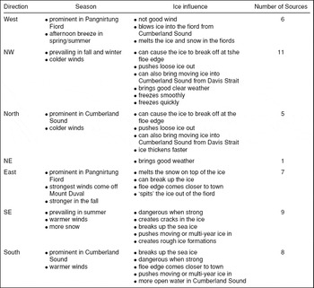
North or northwesterly winds are prevailing around Cumberland Sound (Table 4). The predominance of the northwesterly winds is mainly experienced in the autumn and winter seasons, while the opposing southeasterly winds are more common during the summer (Table 4) (EN1). However, these two winds are known to counteract each other. If one blows for a while the other will almost surely follow (JoP1; JS1; MM1).
And there are four directions of wind, you have the north and the south and the west and the east winds. And the ones that are more prominent in the community are the east winds when they're coming in, shooting in from up the fiord, so they get fairly strong. But the major winds that [Cumberland] sound has are the north and the south. And the north and the south seem to be the strongest in terms of, it's almost like they compete with each other, they more or less take turns. You may have strong north winds at one point and it gets calm and then the south winds will start. It's almost like they're competing against each other, so those are the two major winds within [Cumberland] sound (Maniapik Reference Maniapik2004a).
Summary of predominant directional and seasonal winds around Pangnirtung, and their related influences on sea ice.

Sources: AY1; EN1; JAk1; JaM2; JI2; JN1; JoM1; JoM2; JoP1; JQ1; JS1; LE1; LI2; LN1; MaN1; ME1; MiK1; MM1; MoK1; MoN1; PQ1; PV1.
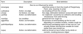
Inuktitut terminology, descriptions, and brief definitions for sea ice conditions associated with wind influences (in approximate order as shown in Fig. 12).

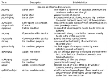
Inuktitut terminology, descriptions, and brief definitions for sea ice conditions associated with current/tidal influences (in approximate order as shown in Fig. 13).

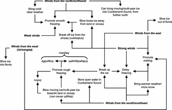
Specifically around the community of Pangnirtung, located in a mountainous fiord of the same name, the topography influences local wind conditions. Because of the orientation of the fiord, it can change the prevailing wind directions more to east/west directions. Therefore, in town the westerly winds are most prominent in the summer, while easterly winds are stronger in the autumn (Table 4). Those winds coming from the west blow in from the mouth of the fiord and are thus called isirsangaq because they are entering the fiord (JoM2), while easterlies come more from inside the fiord, and off nearby Mount Duval (Table 4). The influences of all these winds on sea ice conditions or movement are summarised in the conceptual model shown in Fig. 12.
Conceptual model of the influences of winds on sea ice formation, movement, or decay based on interviews conducted in Pangnirtung.

Influences of wind on ice conditions or movement
North and northwesterly winds are described as prevailing, but more so in Cumberland Sound, away from the topographic effects that the fiords have on wind direction and strength (Table 4). These winds are also credited with bringing cold, clear weather (Table 4, Fig. 12) (AY1; EN1; Alivaktuk Reference Alivaktuk2004 (JAk1); JI2; JS1).
From personal experience, sitting outside when a northwesterly wind is blowing, real cold, [I] know how cold it can be when every time, like you take a fish out of the hole and it freezes right away as soon as you put it down. So it can get very very cold (Anon. 2004).
With northerly or northwesterly winds, sea ice freezes faster and smoother, if they are not too strong (Fig. 12) (JAk1; JaM2; JI2; JoP1; LE1; MM1). However, if the winds are strong they can induce uukkaqtuq at the sinaaq, blowing the ice out towards the mouth of the sound (Fig. 12) (EN1; JaM2; JoM1; JoP1; MiK1; MM1). Furthermore, these winds play an important role in bringing moving and multi-year ice (MYI) down from the north (Lancaster Sound and Greenland) via Davis Strait, and actually blowing it into Cumberland Sound (Fig. 12) (JAk1; JaM2; JoP1; MoK1).
In the early winter if [we] get a lot of northwesterly winds, if you can imagine all of Baffin Island, like right here [going to explain using a map at the back of the room] if you get a lot of northwesterly wind that means all the ice from Lancaster Sound and up here, all the ice would be pushed down here. And then the ice will go into Cumberland Sound sort of on that [northern] side, and then proceed to fill all the fiords with ice. And then later on in August [the moving ice pans], just like animals migrating, they would sort of go along this side of Cumberland Sound, and be spit out on the other side [southern side], almost like a migrating whale or something. So if [we] get a lot of northwesterly winds in the fall that means it's pushing a lot of multi-year ice closer to Cumberland Sound. All the ice would go here by summer, and every summer there's a breeze that goes into Cumberland Sound [from the southeast], and then they would come in here and then they would fill that up [referring to fiords], and then August they would slowly work their way out on [the other] side (Mike Reference Mike2005).
Southerly or southeasterly winds in the fall delay freezing (JAk1; JoP1; JS1; ME1; MM1) and contribute to rougher ice conditions after freeze-up because they push ice towards the head of Cumberland Sound (Fig. 12) (JI2; JS1; LI1; ME1). They tend to break up the ice, even in the winter, and are thus highly influential on the position of the sinaaq (that is stronger southerly winds means the sinaaq is closer to land or the community) (JaM2; JI2; JN1; MM1).
If the ice is kind of thin, then strong winds from here can break it off and get rid of it. However, most of the time it's the southeasterly winds that will jolt it, like sort of move it a little bit, and then the next wind will just pop it right out. Ujutillaq, that's another word, if there is an explosion here, it's the effect, the shockwave (Maniapik Reference Maniapik2004c).
Southerly winds also blow moving or MYI into the sound, filling it up with icebergs and ice pans (Fig. 12) (JaM2; JoP1). In the spring, southerly winds play an influential role in the deterioration and break-up of sea ice, creating more open water (Fig. 12) (AY1; JoM1; LI2; MM1). Therefore, winds from southerly directions are considered more destructive to ice conditions in general, and thus more dangerous for ice travel (AY1; JoM1; LI2; MM1).
This happens in both fall and spring time. When the ice is trying to form a wind will come up and push everything back here and crunch it all up. And then it'll try to form again and it'll get another wind, it'll just keep on doing that until finally it locks in and freezes. And also in the spring time, [the wind] speeds up the break-up of the ice when we get winds that push [the ice] together and crunch them together (Evic Reference Evic2004).
The destructive role of southerly winds is linked not only to wind direction, but also to the fact that they are generally warmer than winds from other directions (AY1; JAk1; JoP1; JS1; LE1).
As alluded to in Table 4 and in the previous section, the fiords around Pangnirtung have a strong influence on wind directions. More commonly in the autumn, very strong winds blow through Pangnirtung Fiord from the east, off the side of Mount Duval (LI2). These winds can delay the freezing process by blowing, ‘spitting’, ice out of the fiord (Fig. 12) (MiK1; PV1). However, this effect is even worse in Kingnait Fiord, which is why the sinaaq is usually close to the islands near the mouth that fiord (Fig. 9) (AY1; JS1). Therefore, the fiords somewhat funnel winds from other directions to create stronger winds along the orientation of the fiord (LI2).
What happens is that because of our mountains . . . when the south winds are coming in strong, they're funneling in through the mountains, through the fiord. They're actually south, they may be south or SE winds. And that's when that the south wind will always have an effect on our sea ice. What happens is that it starts breaking, breaking the sea ice out in the Cumberland Sound. And it also has an effect by way of funneling through our fiord, where it actually starts working on the snow on top of the sea ice (Ishulutak Reference Ishulutak2004b).
In the spring and summer, isirsangaq (Table 4) is most regularly felt in the afternoon and early evening, and it blows floating ice into the fiord (Fig. 12) (JoM2; PV1).
And it never fails, you remember I said there's a breeze [that] comes in the afternoon? And it never fails, come early evening, it just calms up, there's no wind to be heard of anywhere. It's just real flat and you see ice in the water, it's just marvelous, just beautiful . . . And it never fails, you would see, or even think that it's strange that you see people getting ready to go [out] when it's windy in Pangnirtung. You'd find it kind of strange, people getting ready to go out boating when it's really rough in the fiord. But we know that it's going to be calm, early evening, so you just get ready in the afternoon and then shove off early evening. Because you know it's going to calm up, be calm in the evening (Maniapik Reference Maniapik2004b).
Calm conditions promote freezing in the fall (MiK1), while windy conditions can cause the ice to break and pile into rougher formations (maniilaq) (for example the process of aggutittuq) (Fig. 12) (MoK1; PV1). Winds also push new ice on top of other recently formed ice (qalliriittipalliajuq) (Fig. 12) (ME1). Therefore, a lot of wind in the fall creates rough, jagged ice (JI2; ME1). As the ice is thickening, winds can also more easily push ice together causing it to pile up, and create pressure ridges (that is the process of ivujuq) (Fig. 12) (LE1; LI1; ME1; MM1; MoK1). This process can even result in ice being pushed right up onto land, and can occur in any season (LI1; ME1; PQ1). Winds control the timing of freeze-up because they can easily break up, and move, thin ice (JaM2; ME1; MM1; MoK1; PQ1; PV1). They also influence the amount of MYI in Cumberland Sound, which can affect the speed of the autumn freezing process (that is more MYI means cooler water temperatures, and thus earlier freeze-up) (JaM2). Therefore, it is understood that the first ice to form will rarely become solid and stay throughout the winter (JS1; ME1; MM1; PQ1). However, once the ice is solid winds do not have as much effect on ice conditions (JoP1; JQ1). They do play an important role in the melting of snow and ice though, contributing to faster break-up in the spring than the heat of the sun alone (Fig. 12) (AY1; JQ1; MM1).
Tidal cycles and currents
The daily tides operate on a twelve hour cycle between the tide coming in and going out (JaM1). In Cumberland Sound ocean circulation is described as alternating within the tidal cycle in a general east (low tide)/west (high tide) direction (LI2). However, in the northern end of the sound it is also noted that currents move more in a north/south direction (LI2).
Beyond the daily high and low tides, once a month piturniq occurs, the peak high and low tide associated with the lunar cycle (Fig. 13) (EN1; JaM1; JaM2; JI1; JoM1; JoP1; JQ1; LE1; LN1; MiK1). It is most commonly described as the ‘full moon effect’ (AY1; JaM1; JI2; JoM1; JS1; LI2), but it can apply to a new moon as well (JAk1; JS1). However, even within piturniq, there are varying levels of peak tides.
On top of the daily tides there are three other different types of tides, levels of tides. Piturniq occurs once a month where the water level rises a little higher than normal. And then, ok let's say it's January we get a piturniq which is just a regular very high tide, at one point in the month. You know, if you ever look at a tide table, at certain times of the month the tide gets really really high, and then it'll taper off, and then it'll get really really high again, and then it'll taper off. Let's say in January there'll be a big, there'll be an ordinary piturniq, and then in February there would be like a piturnirusiq, which is not as high as the piturniq. However, a couple of times a year, piturnivijjuaq, which is really really high tide and really really low tide at that same day. It's both ways, it works both ways, if we're in a piturniq period the water will be like up to 20 feet, but the low tide during that day it will be like, I don't know, -20 feet. But in regular days, it will be like 15 feet, and then 15 feet. It sort of goes like this in the month (Nashalik Reference Nashalik2004).
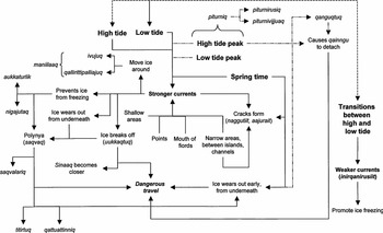
Conceptual model depicting the influences of currents and tides on sea ice formation, movement, or decay based on interviews conducted in Pangnirtung. Where: ————– = general process direction - - - - - = daily cycle – - - – - - – = monthly/intermittent cycle.

Even between years, the current strength is described as variable; some years can have stronger currents than others (JQ2; LI2). The different temporal scales in which the currents can be stronger or weaker also render them more or less influential on ice conditions, respectively.
Current and tidal influences on ice conditions or movement
Underwater topography can strengthen currents as the water travels more quickly through shallow areas, and creates bigger waves (Fig. 13) (JI1; JoM2; JoP1; JQ2; JS1; MaN1; MoN2). Furthermore, narrow sections between islands, in channels, or at points also strengthen the currents by funneling water to higher speeds (Fig. 13) (AY1; JN1; JoP1; JQ2; JS1; LE1; LI2; ME1; MoN2; PV1). The mouth of various fiords were often noted as having strong currents, which prevent solid ice formation and lead to earlier melting (AY1; JI2; JoM2; JQ1; JS1; LI2; ME1; MiK1; MoN1; MoN2).
And also today the terminology used here is aukkaturlik meaning if, like in Pangnirtung we have fairly strong currents at the mouth of the fiord and we as hunters know which particular spots will have very weak ice and it will melt, melt fairly quickly and be open water fairly quickly. And we have them right now at the mouth of the fiord (Nuvaqiq Reference Nuvaqiq2004).
All these conditions will delay the freezing process, while weaker currents (e.g. inirqanirusiit, minor currents) allow the ice to form more solidly (Fig. 13) (JI1; JoM2; JoP1; LI2; ME1; Keyuajuk Reference Keyuajuk2005 (MoK2); PV1).
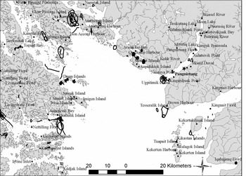
In areas with stronger currents (for example shallow or narrow areas), they can delay ice formation (that is create nigajutait in the autumn) (MM1), or they can prevent ice formation all together and create a polynya (saqvaq) (Fig. 13) (AY1; JI1; JN1; JoM2; JoP1; JQ2; JS1; LI2; ME1; MoK1; MoN1; PV1). The term saqvaq is commonly used to refer to either the continual presence of open water within the tuvaq, or the occasional freezing of these areas during weaker current periods (JAk1; JaM2; JI1; JoM2; JoP1; JQ2; LE1; LN1; ME1; MiK1; MM1; MoK1; MoN2; PV1). These are areas ‘where there are currents’, or ‘fast flowing waters’ (Fig. 14) (AY1; JAk1; JoM1; MiK1; MM1). However, there can also be a distinction made between the two.
There are two different kinds of polynyas, saqvalariq and saqvaq. The saqvalariq, the ice will never freeze there and you can hunt at the edges of the saqvalariq with no worries of being in danger. However, the smaller saqvaqs which are like not as much current, they will freeze in the wintertime, but then they melt a lot faster than the other places in the springtime. They become dangerous sooner than the normal ice, but the ice will freeze for a while there, and those minor saqvaqs are dangerous to hunt at the edge of, because the ice is not as thick (Nashalik Reference Nashalik2004).
Key saqvait located around Cumberland Sound. Sources: AY1; JAk1; JaM1; JI1; JN1; JoM2; JoP1; JQ1; JS1; LE1; LI2; LN1; MaN1; ME1; MiK1; MM1; MoK1; PV1.

Even areas that do not freeze over are often associated with dangerous travel conditions (AY1; JaM1; JaM2; JI1; JN1; JoM2; JoP1; JS1; LE1; LI2; LN1; MaN1; MiK1; MoK1; MoK2; MoN1). However, where the edge of the saqvaq is well defined (LE1), or where titirtuq has occurred (ME1), it can be safe (Fig. 13).
Titirtuq is another term. Like when the ice on the bottom is worn away by the current, and then the snow on top gets slushy from the water, it absorbs the water, and then it freezes over onto a crust, that's how titirtuq . . . becomes safe. It can actually become safe . . . when it freezes over properly like that (Evic Reference Evic2004).
Furthermore, where water has continually splashed up over the edge of the saqvaq the ice can be considerably thicker (qattuattinniq) and thus safer for travel (Fig. 13) (MoK2). Despite the potential to travel safely around some specific saqvait (plural for saqvaq), these areas do tend to wear out earlier than the surrounding sea ice in the spring, and thus become more dangerous (EN1; JaM2; JI1; LE1; LN1; MaN1; MoN2). The size of saqvait also varies along with the monthly moon cycles, whereby they are larger at each piturniq (JI1; JQ2; MoK2). The piturniq period, with its extreme high and low tides, is highly influential on ice conditions and stability (AY1; EN1; JAk1; JaM1; JaM2; JI1; JoM1; JoP1; JQ2; LE1; LI2; MiK1; MoK2). The strength of tides around piturniq can detach the qainngu (EN1; LE1), cause naggutiit to open or widen (AY1; JAk1; JaM1; JaM2; JI2; JS1; LE1), expand the size of saqvait (JaM2; JI1; JQ2; JS1; LN1), or initiate uukkaqtuq at the sinaaq (AY1; JaM2; JI1; LE1; LI2; MiK1). During a piturniq period the ice can also deteriorate faster than the diurnal tidal cycle, it will wear away faster from underneath (Fig. 13) (JAk1; JI2; JoM1; LN1).
When it's full moon, at this time of year [May] when it's starting to melt and deteriorate, when you have that full moon, you can literally see that it actually eats [the ice]. [I] mean it's almost like you're seeing somebody eat something right in front of you. It just literally eats that snow away. So the currents are much stronger then, you know it's just starting to eat the ice . . . And especially in the strong current areas, even in the dead of winter you can have frostbite on your face and yet if the currents are strong enough they will actually eat away the ice, even when it's really cold out. Like it's freezing above the sea ice, but it actually [gets eaten] away in the strong current areas, from the bottom (Maniapik Reference Maniapik2004a).
The action of qanguqtuq can also occur during piturniq, whereby ice is pried off the land by the strength of the tides underneath and water flowing over top of the ice – a very fast, noisy, and scary experience (Figure 13) (EN1).
This is not a gradual process . . . This is like a very scary, noisy process that [I'm] talking about. [I] was on the ice and it sounded like it was being destroyed or something, a lot of noise, grinding and sudden rushes of water sounds. So it's a very, very noisy process . . . When you don't expect it [qanguqtuq] can be very scary because it always occurs very early in the morning. And it's very noisy, only if you're camping by the shoreline will you notice it. But, as soon as you first experience it, then it's not scary anymore, then you know what to expect. But when you first experience it it's like the world is falling apart or something (Nashalik Reference Nashalik2004).
Tides seem to be strongest in the spring, and this can affect ice deterioration and break-up processes (EN1; JoM2; LI2; MoN1). At any time, the currents can be wearing away (melting) the ice from underneath from the water movement or friction on the ice (Fig. 13) (EN1; JAk1; JaM1; JI1; JoM1; JoP1; JQ2; LI2; ME1; MoK2; PV1). This process can be exacerbated where the ice is insulated by snow cover (EN1; JaM1; JI1; JoM1; JoP1; JS1; ME1; MoK2; PV1). Therefore, some areas open earlier in the spring time due to the influence of stronger currents, and thus become increasingly dangerous around mid-April or early May (Fig. 13) (JAk1; JaM1; JN1; JoP1; JQ2; LE1; LI2; LN1; MaN1; ME1; MoK2; MoN1; MoN2).
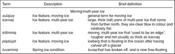
During the autumn, in early stages of ice formation, tidal flats are considered unstable because continual water movement creates considerable variations in water level and thus shoreline ice stability (JaM1). This can also lead to delayed freezing along shore (JaM1; MiK1). Tidal variations can contribute to the formation of cracks in the ice, and when the tide gets lower it can carry out ice that has become detached from tuvaq (EN1; JaM1; JaM2; JI2; JoP1; JoM1; JQ2; MiK1; PQ1), or lead to uukkaqtuq at the sinaaq (JaM2; LE1; LI2; MiK1). Similarly, as the tide gets higher it can also break the ice, detaching it from solid ice and then moving it with the currents to other areas (Fig. 13) (JaM2; JoM1; PQ1). Therefore, tidal movements can also create rough ice formations (maniilaq) through processes such as ivujuq or qalliriittipalliajuq as ice is pushed together (Figure 13) (LE1; ME1; MoN2; PV1). In the summer, where MYI is still present within Cumberland Sound, currents and circulation patterns can cause the ice pans to group and move together into particular areas (LI2; MiK1). A few key terms associated with moving, or MYI, are highlighted in Table 7.
Inuktitut terminology, descriptions, and brief definitions for sea ice conditions associated with moving/multi-year ice.

Discussion
For the Nunavut communities of Cape Dorset, Igloolik, and Pangnirtung, sea ice is an important means of traveling and hunting, and sustaining marine wildlife. As an inherent part of Inuit culture, ice conditions are intertwined with daily activities, in which similarities and variations in localised ice conditions are reflected by Inuktitut terminology and ice uses. In order for people to travel and hunt effectively on the sea ice, they have to become knowledgeable about the complexity and dynamism of the oceanic environment. This was elucidated through detailed explanations of local ice conditions, seasonal processes, and Inuktitut terminology in this paper, as well as in Laidler and Elee (Reference Laidler and Elee2008) and Laidler and Ikummaq (Reference Laidler and Ikummaq2008). Here, we will provide an inter-community comparison of the results presented in the three papers, along with linkages to scientific terminology, as a synthesis of sea ice terminology and conditions. In conclusion, we will discuss the broader implications of these results for collaborative science, education, and heritage initiatives.
Regional sea ice terminology comparison
In each community Inuit experts account for near-shore and open water freezing, as well as several stages of sea ice thickening. Variations in these descriptions highlight some of the unique geographical influences related to temperature and speed of freezing, as well as localised wind and current direction. In addition, local dialects or specific local sea ice uses also influence the degree to which processes are described. For example, in Cape Dorset and Pangnirtung the focus is on shoreline processes in early freezing, due to the prominent tidal variations in these areas, while in Igloolik the focus is more on sea ice thickening. With Igloolik being further north, freeze-up would generally occur more rapidly and with less tidal influence, which may explain the lack of unique terms described in Igloolik for varying stages of along-shore freezing. In terms of open water freezing, the strength of currents is a prominent focus around Cape Dorset, which is reflected in more terms for open water sea ice formation. Within the processes of sea ice thickening, the most commonalities and differences between terminology and ice conditions are highlighted. The terms employed consistently in each community reflect prominent transitional stages during freeze-up (for example sikuaq, nigajutaq, sallivaliajuq, qanguti, sikujuq, siku, tuvaq). Therefore, these are commonly employed bench marks in the progression of sea ice thickening. Within these transitions, the detailed focus in both Pangnirtung and Igloolik is placed on the different thicknesses (that is stability) of sea ice, while in Cape Dorset the emphasis is more on the sea ice surface, and the potential for ice deterioration during the freeze-up process. Once the landfast ice (tuvaq) is solid, snow accumulation on the ice (apulliq) is described in Pangnirtung and Igloolik. Snow also accumulates on sea ice around Cape Dorset, so this term would be understood, although it was not specified in interviews. This phenomenon may not have been emphasised in Cape Dorset because: i) the lesser sea ice extent and thinner ice conditions do not allow as much snow accumulation; or, ii) snow accumulation is implied with reference to tuvaq.
All three communities describe the formation of tidal cracks (naggutiit) in the tuvaq, as well as the opening of these cracks into leads in the spring (aajurait). These relate to different diurnal, and monthly, tidal stages, and serve as important features for hunting and safety assessment in each community. Unique to Pangnirtung are descriptions of minor cracks, former cracks, and openings. In Igloolik, unique crack formations mainly relate to the floe edge or moving ice, while in Cape Dorset unique terms describe the different widths of cracks (or leads) in the spring. These differences between communities seem to relate to the emphasis on landfast and shoreline ice in Pangnirtung (as influenced by the pack ice in Cumberland Sound), the presence of nearby open water in Cape Dorset (especially a concern as cracks widen in the spring), and the importance of floe edge dynamics in Igloolik (for hunting and safety).
In all three communities, common terminology is employed for the floe edge, new ice forming at the floe edge, and ice breaking off from the floe edge (sinaaq, uiguaq, uukkaqtuq, respectively). Due to the prominent nature and importance of these features it is not surprising that they are referenced frequently, and similarly. In Cape Dorset and Pangnirtung they both talk about nunniq, but it is used in a different context. In Pangnirtung this is a common reference to the freezing of Cumberland Sound, when the floe edge is far away. Whereas in Cape Dorset, it is used on the rare occasion that areas of Chorkbak Inlet freeze over. Prominent within floe edge descriptions in Igloolik is a unique emphasis on detailed accounts of floe edge dynamics. This is of most interest to Igloolik hunters since they are the only ones really using the moving ice, in order to hunt walrus. Therefore, it is imperative that they are mindful of the different movements and conditions along the floe edge to safely cross onto, or back from, the moving ice. Because of this, it was anticipated that Igloolik would have the most unique terminology for moving ice due to its implications for travel safety and walrus hunting. However, the most challenging and dynamic aspect of moving ice around Igloolik is at the interface between the floe edge and the moving ice (that is aulaniq), and thus was captured within discussions of sinaaq dynamics. Free-moving ice in open water (that is aulajuq) is further away, so these ice types are less frequently used or seen (and thus perhaps why less terminology is associated with these conditions). The other communities share moving ice references with Igloolik that relate to their localised ice conditions (these are aulaniq in Cape Dorset because the interface between the moving ice and floe edge is close by, and aulajuq in Pangnirtung because the moving pack ice is far out in Cumberland Sound). MYI is referred to as kavvaq in Cape Dorset and Pangnirtung, and as sikutuqaq in Igloolik. However, sikutuqaq would be understood in any community, as the addition of ‘tuqaq’ to the word ending simply refers to being ‘old’.
In all three communities, elders and hunters mentioned that melt processes were hard to describe because they do not actually see the ice melting in the early stages. The sea ice begins to wear away from underneath, so the snow melting on top is the early indication of ice melt stages. A similar level of detail was described regarding the melt stages in each community. However, there were more locally distinct conceptions of ice melt than overlapping ones. The term used to describe areas that open up earlier than others (aukaaniq) is common to all three communities (accounting for dialectical differences). However, in Igloolik it is also used to refer to a polynya (that is saqvaq in Pangnirtung and Cape Dorset), and not only to areas that open early in the spring due to the influence of currents. The term mannguqtuq is also used in all three communities, but the process itself is described somewhat differently in relation to spring snow conditions and timing of occurrence. In Cape Dorset it describes the snow softening and melting, while the ice is still solid underneath (that is comprising aputlariq and qinningijuq). In Pangnirtung it is more of a diurnal cycle (that is comprising mannguqtaliqtuq and qissuqaqtuq) that influences sea ice travel. In Igloolik manguqtuq is a distinct stage in the melt process, leading into puimajuq and qiqsuqaqtuq. Other than these overlaps, the specific conditions relating to snowmelt are unique to each community. This is believed to be linked to the seasonal spring temperatures that vary geographically, thus influencing the speed with which melting occurs and the types of snow conditions produced. As the snow melts, water begins accumulating on the sea ice (immatittuq), creating melt puddles (immatinniit) and melt holes (killait). These are important transition indicators as melting progresses towards break-up, thus they are commonly employed in all three communities. However, in Cape Dorset and Pangnirtung, killait are described earlier in the melt process than in Igloolik, where it takes longer for the ice to wear right through. Two stages of water accumulation and drainage are identified in Pangnirtung and Igloolik (one from snowmelt and another from the ice itself melting). Ice thickness and snow accumulation around Cape Dorset probably does not accrue sufficiently for this dual drainage to occur. Unique to Igloolik are terms describing various surface conditions that contribute to the gradual deterioration of the sea ice. The distinct terms used in Pangnirtung reflect different types of water accumulation on the sea ice, and localised shoreline ice break-up before the tuvaq actually begins breaking up. Perhaps due to its more southerly location and thus the faster progression of melt stages, elders and hunters in Cape Dorset describe fewer melt stages and focus more on the deterioration of shoreline ice, incorporating more terminology during the final stages of break-up. In Pangnirtung specifically, the qainngu breaking off is very important because, until this final stage occurs, it is still possible to travel out of the fiord. Overall, the focus on melting terminology seems to be mainly determined by the limitations for sea ice travel caused by each spring melt stage.
Inuit elders and hunters skillfully incorporate the multiple influences of weather, winds, currents, and seasons in their explanations of sea ice formation or decay processes. While the main directional influences of winds on sea ice are similar in each community (northwest and southeast), the way they manifest themselves is sometimes described differently. For example, the process of the ice freezing upwind (aguttituq) is mentioned in each community, but in Pangnirtung it is more of a rough ice condition than in Igloolik and Cape Dorset (where it is associated with weak winds). In all three communities winds tend to be responsible for the occurrence of uukkaqtuq, as well as the creation of ivuniit and qaliriiktinniit. A generalised description of rough ice (that is maniilaat) is shared between Pangnirtung and Igloolik, and would likely be understandable in Cape Dorset as well. Due to the emphasis on aulaniq in Igloolik, they have the most descriptive terms for rough ice along the floe edge (for example nipitittaq and iilikulaak). Perhaps as a result of the use of proximity to the floe edge, Cape Dorset and Igloolik each have unique terms to describe the manner in which ice breaks off from the sinaaq (those are aukaaq and qaatuq, respectively). In addition, weaker winds contribute to the formation of quvviquat, as described in both Igloolik and Pangnirtung. The greater number of wind influences on the sea ice identified in Igloolik relate to their implications for floe edge and moving ice dynamics. Unique to Cape Dorset are explanations of the manner in which winds influence sea ice formation or movement in open water.
In all three communities, the importance of understanding the diurnal tidal cycle, as well as the monthly lunar cycle was frequently emphasised. Each community experiences some tidal variations during the day, approximately every 6 hours, which influences local ice conditions. However, the tides are more pronounced, with greater variations, in Pangnirtung and Cape Dorset than in Igloolik. The peak high and low tide each day exhibit the strongest currents in a diurnal cycle, but the monthly lunar cycle is of greater importance for sea ice travel. The full and new moons have a significant influence on tide height and current strength. These monthly increases in tidal variation can be most destructive on ice conditions, and can cause the greatest variation in polynya size or floe edge dynamics. In both Pangnirtung and Igloolik this ‘full moon effect’ is referred to as piturniq. Although Cape Dorset elders and hunters did not specify this term in their interviews, it is anticipated that the same term would be employed to refer to the influence of moon phases. In Pangnirtung, different types of piturniq were also discussed in relation to the yearly cycle.
In all three communities, areas with stronger currents are known to move ice around, creating dynamic ice conditions. Terms that are used commonly in each community generally describe the most evident, re-occurring sea ice features created/influenced by ocean currents. As mentioned earlier, it is essential to distinguish between the use of the terminology for polynya in Igloolik (aukkarniq) as compared to Pangnirtung and Cape Dorset (saqvaq). These are important areas, created and maintained by strong currents, and thus they are frequently discussed in each community. However, the dynamics associated with the formation of polynya are uniquely described in Igloolik and Pangnirtung. In Igloolik the focus is on the dynamics at the edge of an aukkarniq, whereas in Pangnirtung emphasis is placed on snow/water formations along the edge of a saqvaq that can become safe (or unsafe) for travel. There is also a distinction in Pangnirtung that identifies a saqvalariq as a polynya that will not freeze in the winter. Otherwise, the polynya references account for occasional freezing in the coldest months, or when the currents are weakest.
Strong currents can also be caused by shallow areas, as discussed in all three communities. Where the ocean floor is close to the surface, the water moves faster, as well as in narrow areas where the water is funneled into closer confines. Unique to Igloolik are the localised influences of MYI that can become frozen into the newly formed ice. These tend to funnel the water from underneath, strengthening currents and wearing away the surrounding ice. In Pangnirtung, the effects of fiords are highlighted, where points of land and especially the mouths of fiords often have stronger currents than in larger areas of open water. In addition, whenever sea ice is moved around, it tends to create rough ice due to ice pan collisions. Therefore, currents are linked to the creation of iilikulaak and aksajutak. In all three communities areas with strong currents, or the times of month when the currents are strongest, are frequently related to dangerous travel conditions. The ice can be eroded from currents underneath, which is often imperceptible at the surface. In addition, the seasonal influences of currents seem more prominent in Pangnirtung and Cape Dorset, most likely due to the greater tidal variations creating more pressure on shoreline ice. The piturniq high tide in mid-winter can cause qanguqtuq, as described in both communities. In Cape Dorset the ice may literally explode upwards due to tidal pressure (that is qaarniku), while in Pangnirtung the qainngu may become detached during piturniq. In Igloolik, the influence of the mid-winter cold means that the sea ice is more brittle, so piturniq tides can more easily crack the ice or cause uukkaqtuq.
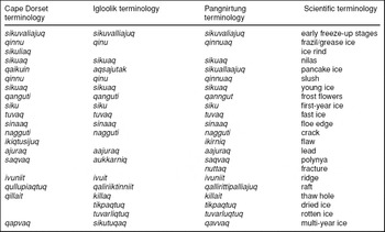
Based on interview results and conceptual models provided in this series of three papers, as well as the synthesis provided here, we now have a very basic platform upon which to build towards a shared understanding of sea ice terminology and conditions. It can be difficult to link English and Inuktitut sea ice terminology due to the nuances of localized terminology referring to practical uses, or specific ice conditions only observed in situ (Ikummaq Reference Ikummaq2004a (TI1); Joanasie Reference Joanasie2004 (MJ1)). There is also the added complexity of contextual references in which different variations of a term will be used depending on whether a person is describing a condition to you from a distance, while on the ice, or while the process is actually occurring (Alasuaq Reference Alasuaq and Elee2004 (AA1)). It is important to note that Inuktitut terminology is very descriptive, so the names are not necessarily always ice-specific. They can be simple descriptors (for example thick and thin, the same words in Inuktitut could be used for ice or a piece of wood), similar to usage in English (PV1; Ammaq Reference Ammaq and Ikummaq2004 (SA1); TI1). This means that terminology analysis alone cannot be used to represent Inuit expertise on sea ice, but it is an important foundation in order to enable interpretation of localised descriptions and assessments of change. On top of this are the dialect differences that surface both within communities, and between communities (Peter Reference Peter and Elee2004 (NP1); Pootoogook Reference Pootoogook and Elee2004 (PP1); PV1; Tapaungai Reference Tapaungai and Elee2004 (QT1)). Nevertheless, just as between communities, there is overlap between Inuktitut and scientific ice descriptions based on major features or seasonal processes (Table 8). This helps to identify common sea ice processes/conditions to which reference is being made. An emphasis on terminology may also improve working relationships by developing a shared lexicon, and expanding our awareness of unique sea ice terms or conditions only described in one language or another.
Overlapping Inuktitut and scientific terminology for sea ice (based on the closest approximations of meaning).

Broader implications
As was the case in the previous two papers, the results expressed here also have the potential to inform the creation or refinement of local/regional sea ice monitoring programmes, educational/language materials and programmes, and the development of future research projects to target community interests (as discussed in Laidler and Elee (Reference Laidler and Elee2008) and Laidler and Ikummaq (Reference Laidler and Ikummaq2008)). Here we wish to explore further why this work is also important outside the community context, as a contribution to the enhancement of collaborative science, education, and heritage initiatives.
First, in collaborating with Environment Canada (that is the Science Assessment and Integration Division, and the Canadian Ice Service) and Noetix Research Ltd., and having received several years of Cryosphere System in Canada (CRYSYS) and Northern Ecosystem Initiative (NEI) funding, it has become apparent that there is broad scientific interest in understanding Inuit knowledge and use of sea ice. Part of this may stem from the challenges of obtaining in situ observations and measurements over sufficient spatial and temporal scales, as satellite sensor resolution, limited ‘ground’ truthing opportunities, and point measurement techniques cannot always provide a comprehensive picture of local sea ice processes (Steffen and Heinrichs Reference Steffen and Heinrichs2001; Dokken and others Reference Dokken, Winsor, Markus, Askne and Bjork2002; Yu and Lindsay Reference Yu and Lindsay2003; Hwang and Barber Reference Hwang and Barber2006; Laidler Reference Laidler2006a; Yackel and others Reference Yackel, Barber, Papakyriakou and Breneman2007). Such local-scale processes are important from a scientific perspective in relation to energy and heat fluxes, the onset of transitional stages, sea ice dynamics (for example polynyas, floe edge), and regional scale climate modeling (Derksen and others Reference Derksen, Piwowar and LeDrew1997; Mundy and Barber Reference Mundy and Barber2001; Yackel and others Reference Yackel, Barber and Papakyriakou2001; Derksen and Walker Reference Derksen and Walker2003; Houser and Gough Reference Houser and Gough2003; Rothrock and others Reference Rothrock, Zhang and Yu2003; Gough and Houser Reference Gough and Houser2005; Hwang and others Reference Hwang, Langlois, Barber and Papakyriakou2007). Therefore, enhanced understanding of local sea ice expertise, and increased local involvement in scientific inquiry, are of growing pertinence in government and research structures (McNaughton and Rock Reference McNaughton and Rock2003; NCP 2003; R. DeAbreu, personal communication, 2004; Graham and Bonneville Reference Graham and Bonneville2004; Nichols and others Reference Nichols, Berkes, Jolly and Snow2004; DE 2005a; DE 2005b; DE 2005c; DE 2005d; B. Goodison, personal communication, 2006; Nickels and others Reference Nickels, Furgal, Buell and Moquin2006; Furgal and others Reference Furgal, Fletcher and Dickson2006; Gearheard and others Reference Gearheard, Matumeak, Angutikjuaq, Maslanik, Huntington, Levitt, Kagak, Tigullaraq and Barry2006; Meier and others Reference Meier, Stroeve and Gearheard2006; Mallory and others Reference Mallory, Fontaine, Akearok and Johnston2006; Berkes and others Reference Berkes, Berkes and Fast2007; Gearheard and Shirley Reference Gearheard and Shirley2007; ITK and NRI Reference Nickels, Shirley and Laidler2007; Armitage and others Reference Armitage, Plummer, Berkes, Arthur, Charles, Davidson-Hunt, Diduck, Doubleday, Johnson, Marschke, McConney, Pinkerton and Wollenberg2008; T. Hirose, personal communication, 2008). One example of this is recent interest from Environment Canada in discussing weather and sea ice forecasting services with a view to improving services and communication strategies by: i) determining local needs; ii) understanding local uses of the sea ice; and, iii) incorporating locally employed indicators and appropriate terminology (R. DeAbreu, personal communication, 2004; Y. Bilan-Wallace, personal communication, 2007; D. Piekarz, personal communication, 2007). Although using community-specific terminology would not be operationally practical for those providing the weather and ice information, there is interest in developing a shared, understood sea ice and weather lexicon to be used in products/services that could be delivered across all northern communities (R. DeAbreu, personal communication, 2008). This interest, and, most importantly, efforts to bridge these ways of knowing and understanding within scientific and decision-making contexts, is evidenced by workshops funded by Environment Canada. These are the ‘Community-based Inuit qaujimajatuqangit (IQ) Weather and Sea Ice Forecasting Workshop’ held in Iqaluit, in March 2007, (jointly funded by Indian and Northern Affairs Canada); and, the workshop on ‘Connecting community observations and expertise with the Floe Edge Service’ held at Cape Dorset, Igloolik, and Pangnirtung, in November 2007, (jointly funded by the Canadian International Polar Year (IPY) programme). As suggested in the title of this second workshop, as part of the Canadian IPY Inuit Sea Ice Use and Occupancy Project (ISIUOP), Noetix Research Ltd. is now collaborating with the communities of Cape Dorset, Igloolik, and Pangnirtung, through the expansion and refinement of the Polar View Floe Edge Service (www.noetix.ca/floeedge). We are working together to develop ways in which hunters’ regular travels can contribute to the improvement and refinement of image products to ensure enhanced product utility in each community. At the same time, these kinds of on-ice characterisations help scientists and ice analysts to understand/identify important local scale features and processes, and to more effectively incorporate other information (for example tide tables, water temperature, lunar cycles, etc.) that hunters would like to consult along with the images (T. Hirose, personal communication, 2008). These efforts aim to improve our joint capacity to monitor hazardous sea ice areas, predict possible break-off events or unstable sea ice, and to assess areas undergoing long-term changes. Community contributions in this regard are essential, and collaboration will also help provide useful information to community organisations and decision-makers. Local expertise and perspectives have long been ignored by scientists and government departments (Laidler Reference Laidler2006b), and the recent progress being made in these arenas is promising. Nevertheless, there remain continuing challenges with initiating and maintaining meaningful collaborations as it can be difficult i) to secure long-term funding to get initiatives off the ground; ii) to provide adequate training and support for community and scientific researchers in collaborative approaches; and, iii) to foster ongoing capacity-building that will facilitate transitions to locally led and implemented projects, with the aim of ensuring sustainable initiatives (Laidler Reference Laidler2006b; Gearheard and Shirley Reference Gearheard and Shirley2007; ITK and NRI Reference Nickels, Shirley and Laidler2007).
Second, there is concern among elders and hunters in the three communities that younger generations are not learning the essential survival skills to ensure safe navigation and hunting on the sea ice (AA1; Ezekiel Reference Ezekiel and Elee2005 (AE1); Irngaut Reference Irngaut and Ikummaq2004 (DI1); LE1; LI1; LI2; MoK2; MoN1; MoN2; Ottokie Reference Ottokie and Elee2004 (OO1); Mikigak Reference Mikigak and Elee2004a (OM1); QT1; TI1; Ikummaq Reference Ikummaq2004b (TI2)). While they have also emphasised repeatedly that the youth need to learn about sea ice by observing, traveling, and experiencing (and not by reading or learning in the classroom) (Qrunnut Reference Qrunnut and Ikummaq2004 (AQ1); Angutikjuaq Reference Angutikjuaq and Ikummaq2004 (DaN1); Kunuk Reference Kunuk and Ikummaq2004 (EK1); Mangitak Reference Mangitak and Elee2004 (EM1); JI1; Solomonie Reference Solomonie and Elee2004 (KS1); MJ1; MM1; MoK2; Qamaniq Reference Qamaniq and Ikummaq2004 (NQ1); TI2), there is a strong simultaneous interest in documenting Inuit knowledge and terminology of the sea ice environment to help bring it into school settings, and to have things in writing so the knowledge is not lost (AE1; DI1; Petaulassie Reference Petaulassie and Elee2004 (EP1); JS1; LE1; MoK1; Mikigak Reference Mikigak and Elee2004b (OM2)). Certainly there may not be the same need to travel and hunt on the sea ice, and some youth may not even be interested, but still many others do use the ice to travel between communities, for leisure (for example snowmobile racing), and for hunting or accessing inland hunting grounds. In these cases, the speed with which people travel, their unfamiliarity with place names and traditional terminology, and their reliance on technology (for example Global Positioning Systems (GPS)) render youth at a higher risk of getting lost or into an accident (Berkes and Jolly Reference Berkes and Jolly2002; Aporta Reference Aporta2004; Nichols and others Reference Nichols, Berkes, Jolly and Snow2004; Aporta and Higgs Reference Aporta and Higgs2005; Nickels and others Reference Nickels, Furgal, Buell and Moquin2006; Ford and others Reference Ford, Smit, Wandel and MacDonald2006b; Gearheard and others Reference Gearheard, Matumeak, Angutikjuaq, Maslanik, Huntington, Levitt, Kagak, Tigullaraq and Barry2006; Ford and others Reference Ford, Pearce, Smit, Wandel, Allurut, Shappa, Ittusujurat and Qrunnut2007). Therefore, having the language skills, survival skills, sea ice navigational skills, technological know-how, experience to instill confidence and independence, and family members or mentors to travel with and learn from, are all inseparable factors in ensuring that youth have sufficient means of safely and independently using the sea ice in modern times. This research can by no means address all these critical elements, and the results could never be used alone to learn about sea ice conditions; however, this work can contribute to some areas that factor into experiential or class-based learning. For example, documentation efforts that contribute to the development of educational materials (terminology, diagrams, and maps, for use in class or for on-the-land programmes) can help facilitate enhanced knowledge transfer between elders and youth, aiding to decrease the generational gap that has arisen due to rapid societal, political, cultural, and economic transformations that have occurred in Nunavut in the past 60 years (Ford Reference Ford2005; Nickels and others Reference Nickels, Furgal, Buell and Moquin2006; Takano Reference Takano2005; Ford and others Reference Ford, Smit and Wandel2006a; Henshaw Reference Henshaw2006; Berkes and others Reference Berkes, Berkes and Fast2007; Laidler and Elee Reference Laidler and Elee2008; Laidler and Ikummaq Reference Laidler and Ikummaq2008).
Finally, documenting and communicating Inuktitut terminology on sea ice is not limited in relevance to linguistic or environmental investigations. Increasingly, this kind of documentation is seen as an exercise in heritage and language preservation, and has been undertaken in various contexts across the Canadian Arctic (for example in grammars, dictionaries, place names, climate change terminology, archeological sites and history) by such organisations as the Inuit Heritage Trust, the Kitikmeot Heritage Society, Nunavut Tunngavik Incorporated, Inuit Tapiriit Kanatami, Labrador Heritage Society, and local heritage centres (along with northern governments). In addition, efforts have been invested in creating new terminology to reflect legal language, office environments, and so on, to ensure the vitality and relevance of Inuktitut (such as those created by Nunavut Arctic College). However, elders and hunters still worry that traditional sea ice terminology, with its nuanced and deep meaning, is not being used regularly anymore, and is often not understood by youth or even middle-aged adults (AA1; Taqqaugak Reference Taqqaugak and Ikummaq2004 (AT1); EP1; DI1; JAk1; JaM1; JQ1; Qaunaq Reference Qaunaq and Ikummaq2005 (LQ1); MJ1; OO1; OM2; PP1; PV1; QT1; Tapaungai Reference Tapaungai and Elee2005 (QT2); SA1). Therefore, the documentation of more traditional terms is especially important not only as a means to learn sea ice conditions, but also to help provide historical perspective on both environmental and cultural transformations. Undoubtedly, language documentation alone does not constitute heritage preservation, and documentation should not be confused with an attempt to render results final, or to interpret language or culture as static. Indeed, it is only through the use of language, the practice of cultural activities, and continuing adaptation and innovation that language and culture evolve together in a healthy and sustainable manner. For example, the use of GPS technology (and to some extent satellite imagery as well) has become incorporated into community members’ assessment of sea ice safety and navigation, alongside more traditional skills. These resources cannot replace traditional skills, but individuals’ skill sets expand to incorporate the most effective methods of assessing safety in a complementary fashion. This reflects healthy evolution of Inuit knowledge, tailoring newly available information sources to environments that are uniquely used by Inuit to this day. With the expansion of knowledge and language documentation through digital media and developments in interactive online communication and education, the preservation of cultural heritage not only benefits Inuit, but can also raise broader awareness regarding the value and importance of Inuit knowledge and culture, nationally and internationally. Therefore, collaborative efforts are also particularly effective in heritage initiatives, combining various forms of expertise to meet northern goals and priorities.
Conclusion
It is hoped that this series of papers depicting human geographies of sea ice has helped to highlight the importance of avoiding generalisations based on community-specific research. While there are certainly similar ice conditions and terms used in each community, Inuktitut dialect, geography, oceanographic and climate conditions, variations in hunting and travel practices, along with circumstantial and cultural context, all influence the results presented. Therefore, when attempting to link Inuit knowledge to regional scientific sea ice studies it is recommended that there be focus on the regional vicinity which is used by community members, as extrapolation beyond locally utilised extent may not be appropriate/applicable (or may require the involvement of a different community). There is still room for regional characterisations based on the key similarities that communities do share, but we hope to have highlighted that there is enhanced depth to such investigations when working at the local scale as related to community use and surrounding ice extent. Nevertheless, these results can also contribute to initiatives beyond the local context. Localised details, when taken together, can help develop enhanced perspective on community-based knowledge and experience in Nunavut. It is therefore emphasised to consider, and to continue reflecting upon, the potential broader implications of community-specific research for collaborative science, education, and heritage efforts (in this case within the realms of sea ice and marine environments). It is especially important to communicate such results to decision makers, service providers, educators, and heritage associations to promote further discussion, feedback, and improvement of results, and their applications, for the benefit of Inuit communities.
Acknowledgements
We have made specific acknowledgements for the contributions from Cape Dorset and Igloolik in Laidler and Elee (Reference Laidler and Elee2008) and Laidler and Ikummaq (Reference Laidler and Ikummaq2008), respectively. For the basis of this paper, we are grateful for the support and collaboration of community members and local organiastions in Pangnirtung that made this research possible, most notably the elders and hunters who shared their knowledge through interviews and sea ice trips. Special thanks also goes to the Hamlet of Pangnirtung, the Pangnirtung Hunters and Trappers Association, the Nunavut Arctic College Community Learning Centre, Parks Canada, the Angmarlik Visitor Centre, the local Qikiqtani Inuit Association, and the Government of Nunavut Environment and Education Departments which helped facilitate this work and/or provided interview and meeting space. Interviews conducted were in compliance with ethical protocols at the University of Toronto, and were conducted under a multi-year Nunavut Research License (#0100504N-M, January 2004 – December 2006). Financial support for this research was provided by the same sources listed in Laidler and Elee (Reference Laidler and Elee2008). We also thank two anonymous reviewers for their helpful comments in refining this manuscript.