

Since the late 1980s, large and small holes in the ground have swallowed more and more of the shoreline around the Dead Sea. Some holes are as large as a city block and just as deep, while others are as small as a loaf of bread and look like the footprints of a very heavy giant. Many sinkholes appear in linear clusters, strangely patterned additions to an otherworldly landscape. Some sinkholes form round natural pools filled with water, while others are dry down to depths that can hardly be seen from the hole's crumbling edge. Dead Sea sinkholes look most dramatic when they disrupt structures of the built environment. They rip apart buildings, tear up roadways, and leave previously buried pipes dangling precipitously over a chasm that was up until the moment of collapse solid ground filled with earth. When sinkholes appear in parking lots or roadways, the asphalt cracks like ripples and it appears that the earth is in the process of falling away, but has frozen midcollapse. Despite their frightening ability to destroy the necessary conditions for daily life, people live and work with Dead Sea sinkholes in the Occupied Palestinian Territory (oPt), Israel, and Jordan.
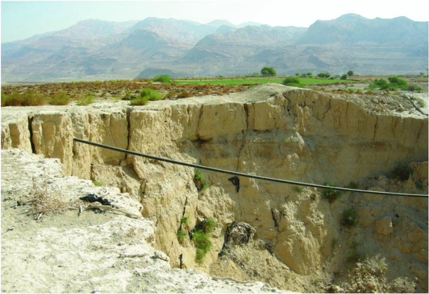
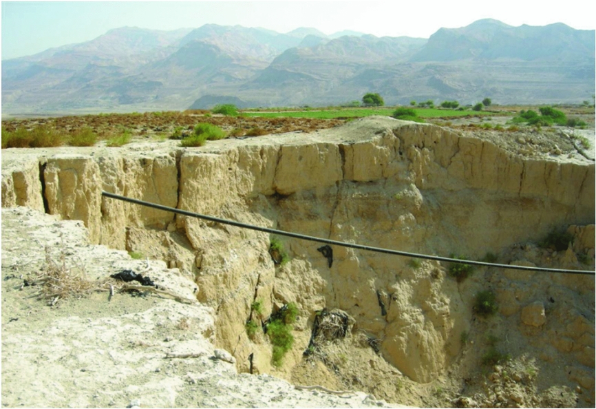
Debates over territory unfold in the ways differently positioned scientists and engineers study and predict Dead Sea sinkholes (Figure 1). For the Jordanian and Israeli governments,Footnote 1 knowledge about Dead Sea sinkholes has a particular role to play in the claiming of land around the Dead Sea for three reasons: first, because the area is both environmentally hostile and sparsely inhabited, settling the land through more traditional settler colonial means is impractical; second, because the Dead Sea area is economically and religiously important, studying, predicting, and ultimately controlling the hydrogeologic forces that threaten it is crucial to the maintenance of competing colonial claims in the Dead Sea basin; and third, because Dead Sea sinkholes unsettle the Zionist settler colonial project of making the desert bloom by swallowing that very desert.
Sinkhole in Jordan. Photo by author.
Social theorists have recently offered new ways of thinking about social life at the Earth's margins.Footnote 2 Sinkholes are among these marginal places because they undermine and limit human inhabitation. They are also materially marginal: as hydrogeologic formations, they are formed by interactions among waters, land, and human desires to exploit their environments’ economic resources. In this article, I analyze hydrogeologic knowledge about Dead Sea sinkholes as scientific objects suspended in numerous social, political, and economic contestations.Footnote 3 In this geographic context, settler colonial efforts to settle certain kinds of humans in “new” territory (terra nullius) have defined the everyday lives of those who live around the Dead Sea. I show here how “territory” is not a prefigured category, but rather produced through social action and knowledge-making practices.
This article is based on fieldwork I carried out between 2012 and 2015 in the oPt, Israel, and Jordan with geologists, hydrologists, and geomorphologists who study Dead Sea sinkholes, as well as people who live and work in active sinkhole areas. I investigate the processes of gathering and circulating hydrogeologic knowledge about Dead Sea sinkholes, processes that contribute to political contestations over territory. They include sharing work on Dead Sea sinkholes at conferences, methodologically framing new sinkhole research, and using InSAR satellite images to predict sinkholes. I propose attention to “geologies of erasure,” by which I mean the results of hydrogeologic knowledge-making practices in contexts of deep power inequality, to make sense of the epistemic and political effects of the gathering and circulation of scientific knowledge about environments.Footnote 4 Geologies of erasure reveal the political and pragmatic impacts of the scientific knowledge-making practices. In contested settler colonial landscapes, these impacts include the definition of territory as territory that can be settled.Footnote 5 My ethnographic analysis of geologies of erasure will reveal what is erased or nullified in the production of territory through unequal processes of knowing.
First, I will contextualize the phenomenon of Dead Sea sinkholes in the contemporary history of resource extraction in the Jordan Rift Valley. Then, I will bring together recent studies in environmental anthropology with important work on environmental history in the Middle East and North Africa (MENA) to elaborate the concept of geologies of erasure. To illustrate this idea, I will detail four ethnographic examples of the differing scalar approaches to Dead Sea sinkholes developed by different groups of people studying, living, and working with them: international water managers, Palestinian academic scientists, geologists working for the Geological Survey of Israel, and inhabitants of the Bedouin towns on Jordan's Lisan Peninsula, where sinkholes in Jordan are most concentrated.
THE DEAD SEA AND ITS SINKHOLES
Located in the Jordan Rift Valley between Lake Tiberius and the Red Sea, the Dead Sea is a hypersaline inland lake that was fed until the 1960s by the waters of the Jordan River, which have since been diverted upstream for agricultural use primarily in Israel and Jordan.Footnote 6 Only forty kilometers from Jerusalem and fifty kilometers from Amman, the Dead Sea's shores are measured at 426 meters below sea level and falling, the lowest dry land on earth. As the millions of international tourists who visit the sea's shores can attest, the desert that flanks the Dead Sea is spectacular and captivating. Ibexes with squat legs and long, arched horns nibble leaves off acacia trees against the red-orange backdrop of stark, rocky cliffs.Footnote 7 As the sun rises and sets each day, the striking blues, whites, and rusty reds of the water and the rock seem to change in saturation and intensity. Glistening white salt crystals form on smooth gray stones at the water's edge where the small waves hit sections of undisturbed shoreline. In the shadow of limestone and dolomite cliffs, the sea's shores are a mixture of gravel, clay, and sand.Footnote 8 Underneath it all, pockets of salt karst betray the one-time existence of ancient salty lakes: the Sedom Lagoon of the late Miocene and Lake Lisan of the late Pleistocene.Footnote 9
The Dead Sea itself feels unlike any other water most people have ever touched. It is soft, almost velvety, thick with minerals such as bromide, magnesium, and potassium.Footnote 10 At the beginning of the British Mandate in Palestine and Transjordan, surveyors speculated that the Dead Sea could supply the world's need for potash (a potassium-based fuel source and agricultural fertilizer) for the subsequent 9,000 years.Footnote 11 The human rights group al-Haq ranks the Dead Sea and its mineral-rich waters as one of a speculative future Palestinian state's most important and lucrative natural resources.Footnote 12 It is the Dead Sea's biblical importance, however, that made it an object of such fascination for European and American explorers, industrialists, and colonial officials since at least the mid-19th century.Footnote 13 As sinkholes swallow more and more traces of this history, the problems posed by the depletion of the Dead Sea's waters take on a new urgency.
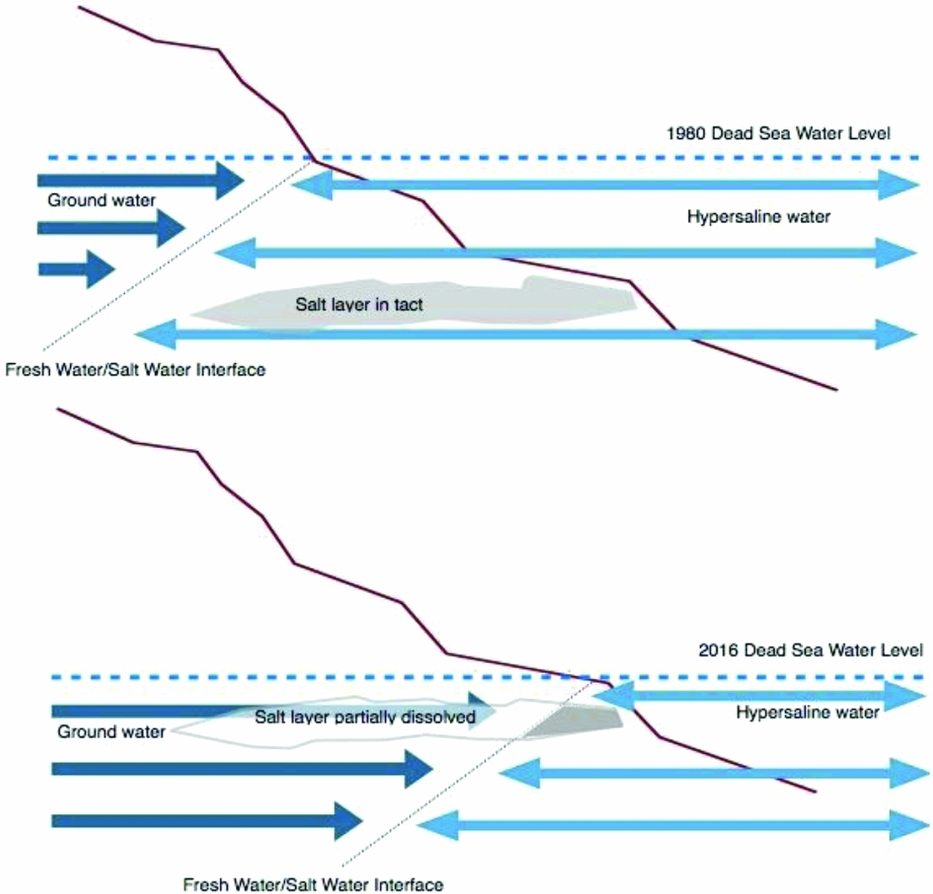
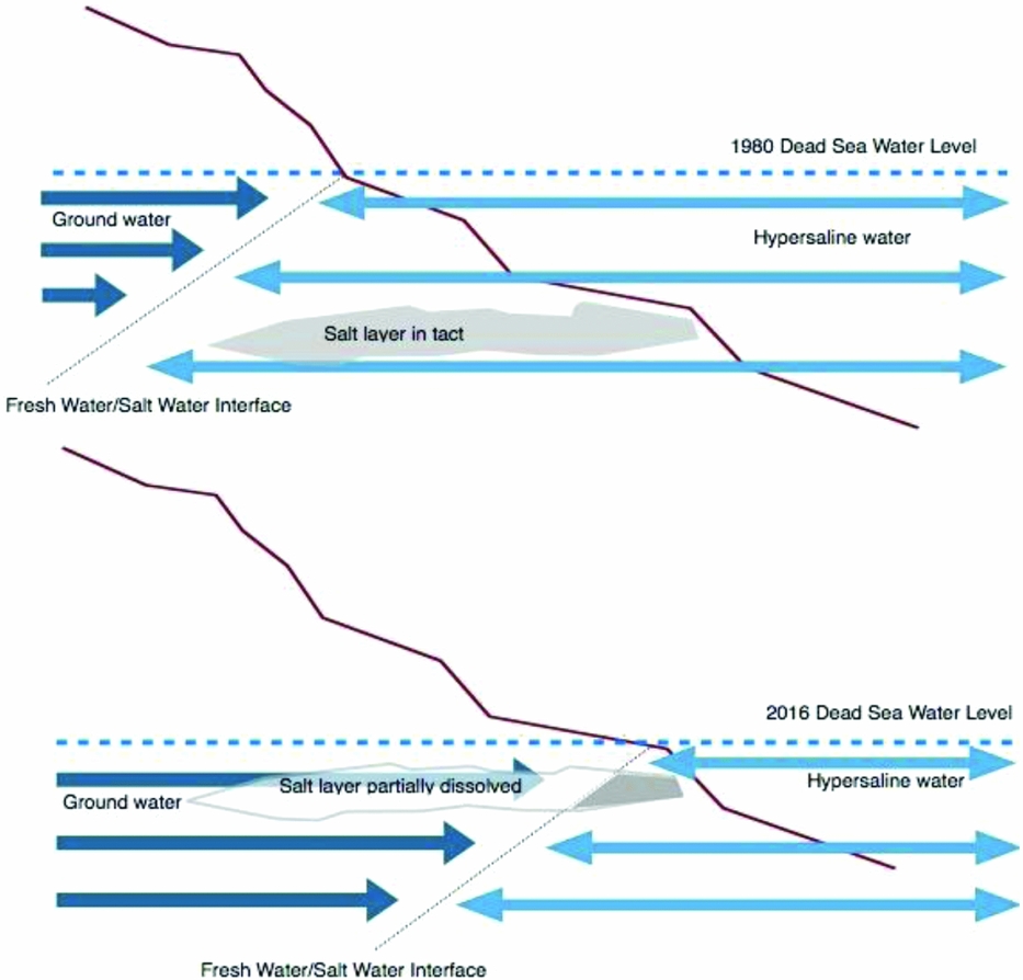
The Dead Sea's salty waters now recede by more than a meter per year as a result of agricultural diversions in the Jordan River and rapid industrial evaporation in the Dead Sea's southern section.Footnote 14 Old docks dangle uselessly over the dry ground many meters from the water's edge. Beachgoers are left to pick their ways daintily across more and more burning sand and sharp stones with each passing day in search of cool relief in the blue-green hypersaline lake. The disappearing water has had damaging effects under the shoreline as well. Sinkholes open unpredictably on the surface of the desiccated landscape as a result of a deteriorating hydrogeologic border called “the freshwater-saltwater interface” (Figure 2). This underground boundary below saltwater shorelines marks the point where groundwaters and saltwaters meet. As the Dead Sea's salty waters are depleted, the border between waters of different salinity moves toward the receding shoreline. When groundwater saturates new underground spaces, it dissolves salt deposits left from the late Pleistocene, forming networks of buried caverns of unknowable size.Footnote 15 When the tops of these caverns collapse, sinkholes appear along the sea's edge.Footnote 16
Sinkhole Formation. Graphic by author.
The rapid depletion of the Dead Sea's waters, and the sinkhole crisis that results, has its historical roots in two disputes for control over the Dead Sea basin's economic resources: first, in the Ottoman-style resource concession granted to Siberian industrialist and Zionist Moshe Novomeysky by the British Mandate governments in Palestine and Transjordan in 1920, now guaranteed by the State of Israel to a privately held company;Footnote 17 and second, in Israeli and Jordanian competition for the waters of the Jordan River. This latter dispute has led to the diversion of 800 million cubic meters of water per year to the Israeli National Water Carrier below the Israeli-built Deganya Dam. Only 200 million cubic meters per year of the Jordan's waters (much of which is sewage outflow from the Ramallah suburb of Beitunia) now flow into the Dead Sea.Footnote 18 Since historical catalysts of Dead Sea sinkholes are tied to resource claims, efforts to predict and understand them must also be viewed as inherently linked to efforts to extend colonial control.
The locations of Dead Sea sinkholes in border regions between the West Bank, Jordan, and Israel makes them difficult to quantify because militarized borders restrict researchers’ and residents’ movement.Footnote 19 In 2015, my interlocutors estimated that over 5,000 sinkholes now dot the landscape of the lowest place on Earth, but this was an unconfirmed best guess and the exact number remains elusive.Footnote 20 As the soft earth along the Dead Sea's shores caves in, it takes concrete, asphalt, electrical wires, metal pipes, donkeys, cars, bulldozers, and occasionally people with it. Donkeys trapped in sinkholes have to be fed by hand until they can be hoisted to safety by Civil Defense. People who have fallen in have been lucky so far. Sinkholes are often so deep that cell phones have no service at the bottom, so people who end up at the bottom of sinkholes depend on friends and colleagues to notice they have gone missing and sound the alarm.Footnote 21 Since the 1980s when they first appeared in the small Israeli town of Neve Zohar, Dead Sea sinkholes have disrupted global commodity chains, border control regimes, agriculture, tourism infrastructures, industrial manufacturing, military installations, and the everyday process of daily life at the Dead Sea.Footnote 22 Dealing with the problem has become a paramount concern for farmers whose fields are sinking, leaders of Dead Sea industries, managers of Dead Sea tourist beaches, government functionaries whose tax revenues are derived from these tourist beaches, and scientists invested in the longevity of this unusual place and its unique environment.
Recent work focused on human–environment relations in the Middle East has engaged these relations from a historical lens. Environmental historians of MENA have provided critical insights into hidden continuities in imperial, colonial, and postcolonial politics and narratives of landscape in the region.Footnote 23 A focus on environmental history in the region has also contributed to a body of work on “environmental orientalism” that until recently had been based on studies in Asia.Footnote 24 This scholarship has demonstrated the persistence of environmental orientalism, at times in unexpected domains far outside of the colonial period. Contemporary understandings of environmental crises in the region are distorted by colonial visions of the landscape, just as “colonial understandings of environmental history of the MENA region were distorted by orientalist assumptions” in the 19th and early 20th centuries.Footnote 25 Social research on energy economies, petrostates, and oil and natural gas extraction in the regionFootnote 26 has shown that scale is one of the key features that distinguishes colonial era “environmental imaginaries” from their predecessors.Footnote 27 Diana Davis's work makes clear that imperial projects and colonial regimes bolstered their moral arguments for control over territory under the guise of ecological or environmental stewardship by construing indigenous inhabitants of the region as unworthy custodians of its natural resources and environmental health.Footnote 28 As will become evident, the continuities among imperial-, colonial-, and nationalist-era environmental imaginaries persist today, and their colonial effects endure as well.
Geologies of erasure point to the contested politics of knowledge-making practices through which human–environment relations are understood as they relate to geologic phenomena. Like environmental orientalism, geologies of erasure draw our attention to the way knowledge making in the natural sciences is inseparable from its sociopolitical contextFootnote 29 and focus attention on the practical and political outcomes of such knowledge-making practices. In the case of Dead Sea sinkholes, these outcomes include (among other things): the nullification of Palestinian claims to the Dead Sea, the elimination of Palestinian people from Dead Sea landscapes, the exclusion of Palestinian scientists from international scientific networks, and the absence of Bedouin objections to Jordanian government policies in official discourse.
This discussion of knowledge making and political stakes orients toward the nonbiological world, into the realm of salt, karst, water, sediment, clay, and gypsum. Contested environmental knowledge-making practices around the Dead Sea require us to take seriously the geology which has structured the region's histories of settlement, resource extraction, and military occupation.Footnote 30 The material properties of this place, though they are nonliving, will surely play a significant role in determining the future of its inhabitants.Footnote 31
The encounters I detail took place at universities, in the offices of state bureaucrats, as well as at the Dead Sea itself. They occurred in the oPt, Israel, and Jordan. The scale of knowledge making about Dead Sea sinkholes is either regional and “at the level of the watershed” (as in the case of international and Israeli consultants, water managers, and scientists), quasinational (as in the case of Jordanian and Palestinian geologists and hydrologists), or hyperlocal (as in the case of Bedouin communities in Jordan). Through attention to the colonial approaches to territory that have leached into the way people study Dead Sea sinkholes, epistemic effects of a militarized landscape become visible. These effects are geologies of erasure.
WATERSHEDS AND NATION-STATES
In a heavily air-conditioned room in the suburbs of Tel Aviv, I spent two days drinking instant coffee and scribbling notes at a “transboundary” water conference about the Jordan River Watershed. Israeli, American, and Western European scholars and development consultants had come together under the florescent lights to seek solutions to a variety of environmental crises plaguing the Jordan River and the Dead Sea, sinkholes chief among them. A Jordanian government official delivered the keynote address. He was the only Jordanian who attended, but he headed immediately for the door when he finished his presentation, leaving the Israelis, Europeans, and Americans to speak amongst themselves. In the hours that followed, workshop participants argued about the trustworthiness of Palestinian water consumers (none of whom were present), the merits of international river commissions, and game theoretic water conservation strategies. One common perspective prevailed among these academics, consultants, and policy practitioners: as an American hydrologist put it, “we water people think at the level of the watershed, not the nation.”
The irony of making such a statement in an academic milieu characterized by identity politics and anticolonial boycotts was perhaps lost on this well-dressed scientist in the middle of his international business trip half a world away from home. In this region with its colonial histories and presents, contested and militarized borders create barriers to the production of scientific knowledge about hydrologic and geologic phenomena.Footnote 32 In the context of ongoing struggles for self-determination and national recognition, the Dead Sea sinkhole problem—and differing epistemological approaches to it—highlights how the long-term militarization of landscapes in the oPt, Israel, and Jordan makes its way into halls of state power, offices and labs of geologists and hydrologists, and conference rooms full of international development consultants far from the sea's shores.
Complex bureaucratic and military regimes govern land use and mobility in the Dead Sea basin. Exploring the full range of these regimes is beyond the capacity of this article, but a short discussion of them is nonetheless crucial to understanding geologies of erasure produced by sinkhole science. Ottoman-era legal structures govern Palestinian land use and land ownership in the oPt, but do not apply to Israelis living in the oPt.Footnote 33 The unevenly and haltingly implemented Oslo Accords of the 1990s divided the oPt into three jurisdictional zones. In Area A, the smallest, the Palestinian Authority (PA) has full military and civil control, if only nominally. In Area B, the PA has civil but not military control. In Area C, by far the largest, the Israeli Civil Administration—based in a settlement that abuts Ramallah—maintains civil control and the Israel Defense (IDF) Forces maintains military control. The occupied sections of the Jordan Valley and Dead Sea basin fall entirely into Area C.Footnote 34 The system of military checkpoints throughout the West Bank does not map on to either the boundaries created by the Oslo Accords nor the 1949 Armistice Lines. These checkpoints can move or change their status without notice.Footnote 35 A dizzyingly complex and occasionally overlapping bureaucratic system of identity documentation further complicates restrictions on mobility. A Palestinian resident of the West Bank might have a PA identity card, a Jordanian laissez-passer which allows them to live in Jerusalem but does not confer citizenship to any nation, perhaps even an Israeli passport identifying their nationality as “Arab” and their citizenship as “Israeli,” or permanent residency documents for other countries for which they have qualified.Footnote 36 The IDF has planted land mines in the Golan Heights and throughout the Jordan Rift Valley as recently as 2011.Footnote 37 The “Separation Barrier” made of concrete and barbed wire as high as eight meters in places cuts through municipalities large and small, including the city of Jerusalem.
Each piece of this puzzle has far-flung effects across time and domains, including in the coproduction of sinkholes as objects of geologic knowledge. The border between the West Bank and Jordan, in Area C, remains a closed military zone throughout the Jordan Valley except for a small tourist site opened in 2011 and run by the Israeli National Parks Authority on the Jordan River at a possible baptismal site of Jesus. (This is one of eleven Israeli National Parks in the oPt, and to my knowledge it is the only one at which IDF soldiers are actively stationed during open hours.) Nowhere does the PA control its own borders, and very little of Areas A or B is contiguous. The Palestinian Authority's Palestinian Mine Action Committee (PMAC) cannot clear Jordan Valley mine fields, which fall within Area C, without going through the Israeli Civil Administration.Footnote 38 This is a fragmented landscape, above as well as below ground.
Imagining an existent sovereign State of Palestine in the oPt requires an intellectual leap, even for proponents of notions such as “fragmented” sovereignty.Footnote 39 By contrast, Israeli monopolies on the use of military force throughout Israel and the oPt are nearly impossible to refute. A 2013 World Bank report found that West Bank Palestinians without permission to enter Israel in the form of a visa are excluded from entering over 99 percent of Area C, which includes nearly all of the West Bank's natural resources.Footnote 40 In Area C, the Israeli government actively pursues policies encouraging Israeli Jews to move into newly constructed settlements, deemed illegal under international law, through development permits and the construction of infrastructures including highways, electrical wires, and pipes connecting them to systems within Israel. In settler colonialism, settling territory seen as “empty” is the key mode of gaining sovereign control, rather than extracting resources or occupying by force as in other colonial schemas.Footnote 41 These on-the-ground realities of settler colonial occupation are erased in the hydrogeologic paradigm of “thinking like a watershed.”
Military regimes that reinforce sovereign control are now being interrupted by environmental crisis. As Dead Sea sinkholes destroy the built infrastructures of settler colonialism in Area C, as in other areas, they subvert these colonial imaginaries and mechanisms of military control. As groups and institutions based in centers of political power such as Jerusalem and Amman try to bring Dead Sea communities under their control, sinkholes upend this process as they destroy infrastructures such as electrical grids and roads. The ways scientists, tourists, and farmers understand, study, and seek to control this crisis on the Dead Sea's shores have great bearing on political and social relations on both sides of the sea because they help define (or contest) the sea's shores as territory that can be settled or colonized in particular ways.
SUBTERRANEAN SCIENCE UNDER OCCUPATION
The office of Dr. Raed Ibrahim,Footnote 42 a Palestinian geologist, has an item arranged on nearly every flat surface. The top of a file cabinet bears a collection of empty bottles of Jericho Water, each a little off kilter with its clear blue plastic sides dented, each in a unique way. Dr. Raed uses these to collect field samples since funds for research supplies are very limited. A side table holds a pile of small stones whose smooth, matte surfaces and colorful layers suggest they were formed in the Dead Sea basin. The professor's desk is the resting place of special treasures from his geological field surveys, including quartz crystals and a large feather of a rare bird. Down the hall in a GIS lab, a graduate student can usually be found struggling with an uncooperative printer. These are scenes familiar to anyone working in a university setting, whether in California or under occupation in the West Bank, where Dr. Raed carries out his teaching and research. His work has taken him all over the West Bank, including to the edge of the Dead Sea. He has not yet published on sinkholes, but has wanted to do so for years.
Dr. Raed says he first became interested in Dead Sea sinkholes during his Master's and doctorate training at a small university in Jordan. He maintains close professional contacts with many of his Jordanian former colleagues who remain there, but his research agenda is now confined to the West Bank. He has conducted hydrologic research on multiple catchments around the West Bank and published the results of a few sociological surveys involving local Palestinian populations, with an eye toward identifying points of possible intervention for future environmental conservation efforts. None of these were at “the level of the watershed,” however. We have discussed collaborating on a quantitative and qualitative study of Dead Sea sinkholes for some time, but we are always confronted with a point of difference. When I envisioned a comprehensive Dead Sea sinkhole study, I imagined one that either addresses the problem on both the eastern and western shores of the sea (in which case, field surveys would be impossible for Dr. Raed who does not have permission to cross Israeli checkpoints or enter Jordan), or one that takes a hyperlocal approach to a single cluster of Dead Sea sinkholes (perhaps a set in the West Bank north of the Israeli checkpoint near the settlement of Mitzpe Shalem). Dr. Raed, on the other hand, intends to design a project that includes some Dead Sea sinkholes as well as areas of subsidence in urban environments in Areas A and B such as among the auto repair shops of Beituna. Dr. Raed's position puzzled me slightly, as I had understood Dead Sea sinkholes to be different from other sinkholes in the region because of the way they formed. At first I attributed the difference to a geological convention I did not fully grasp, but subsequent conversations with Dr. Raed and other sinkhole scientists suggested a different explanation.
All sinkholes collapse because of the dissolution or evacuation of some underground geologic layer—any time cavities form underground, whether through weather-triggered erosion of naturally occurring limestone karst, the overwithdrawal of groundwater, or limestone quarry activity, a sinkhole is likely to eventually result on the surface.Footnote 43 Numerous types of sinkholes, including dissolution sinkholes, cover-collapse sinkholes, and cover-subsidence sinkholes are often differentiated in localized studies of particular sinkhole phenomena.Footnote 44 Dead Sea sinkholes are generally dissolution or cover-collapse sinkholes, and they are all formed as a result of the depletion of waters in the Dead Sea.Footnote 45 All Dead Sea sinkholes thus have a shared geological history, and a shared catalyst. Areas of subsidence in urban zones of the oPt occur as a result of a wide variety of other factors, from poor drainage at industrial sites to badly constructed roads. They include dissolution, cover-collapse, and cover-subsidence sinkholes.
I thought at first that these distinctions would be of paramount importance to Dr. Raed, but my own conceptualization of the sinkhole problem failed to account for the political boundaries of the militarized landscape with its settler colonial divisions. In Dr. Raed's words over coffee in Ramallah one night, “of course I can't gather data about most Dead Sea sinkholes, even on the Palestinian side. If I am too near the checkpoint and they see me with my instruments. . . . what if they shoot me?” It became necessary for him to see scientific similarities among things that could be studied despite the restrictions of the military occupation. He conceived of a study that included a few Dead Sea sinkholes (a small cluster least likely to arouse military suspicion) as well as areas of urban subsidence throughout the West Bank.
For Dr. Raed, Dead Sea sinkholes are not comparable or commensurate to each other. Rather, they are comparable to other incidences of subsidence that he can access. These geologies, while seemingly scientifically similar, are made incomparable by the military and political realities that underpin the life and work of this scientist as he tries to access them. Dr. Raed's epistemological approach to a sinkholes project reveals the impossibility of comparing geologic phenomena as a result of the sociopolitical context in which they occur. It also reveals aspirations for statehood—this would be a study of Palestinian sinkholes. Sinkholes as objects of geological study and aspirations for Palestinian self-determination are thus coproduced. In this sociopolitical context, a legacy of a history of colonial occupations (British, Jordanian, and now Israeli) determines what can be known about sinkholes and by whom. Dr. Raed, with his academic position at a Palestinian university in the West Bank, his Palestinian Authority identity card which prevents him from crossing Israeli checkpoints set up inside the oPt as well as over the 1949 Armistice line that divides the oPt from Israel, and his exclusion from Hebrew-language Israeli academic exchanges, responds to the question of geological scale of Dead Sea sinkholes through his particular position vis-à-vis the militarized landscape.
Knowledge about territory, whether natural scientific or social scientific, is instrumental in controlling it.Footnote 46 Restrictions on mobility are only one of the ways the Israeli occupation of the oPt limits how much Palestinian scientists can know about Dead Sea sinkholes. Because the IDF intermittently cut off access to the Dead Sea from Palestinian population centers in the West Bank during the first and second intifadas, most Palestinian scientists I interviewed became interested in Dead Sea sinkholes through research conducted outside of the oPt, whether in Jordan or Israel. Few Palestinian friends outside of Jericho had heard of the problem unless they worked in service or manufacturing jobs in Israeli settler-owned Dead Sea industries. This face is perhaps not surprising given the fact that few of them spent much time at the Dead Sea and almost none of them visited areas outside of settlement-owned tourist beaches such as Qaliya at the very northern tip of the sea. One of the effects of the prolonged militarization of this landscape has been a social estrangement from Dead Sea environments on behalf of many Palestinians. During my participant observation in Israeli settlement-run gift shops and private tourist beaches in the oPt, Palestinian employees in these settlement-dominated Dead Sea industries talked frequently about how younger generations have lost the opportunity to enjoy excursions to the Dead Sea, and as a result are less interested in it. Because Palestinian access to the West Bank section of the Dead Sea is controlled either by settlements which are illegal under international law or by the Israeli National Parks Authority, some young Palestinians refuse to go out of political conviction— “I boycott the Dead Sea” was a common refrain. The militarization of this landscape in service of the extension of settler colonies has produced this disconnection.
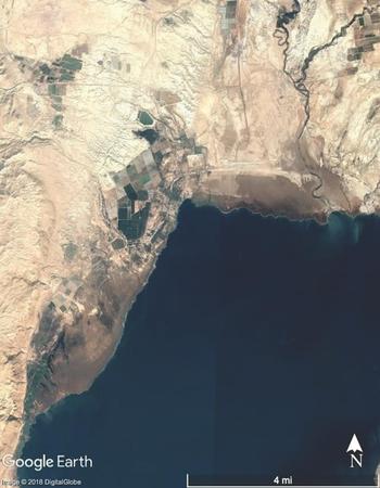
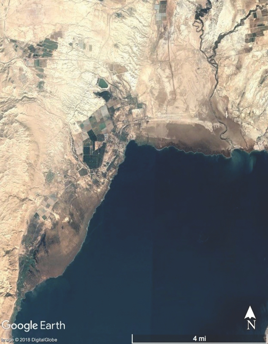
The sinkhole problem at the Dead Sea is further obscured for many Palestinian academics and PA planners because of how difficult it is for them to get up-to-date, accurate maps of the oPt. During my first trip to a Palestinian Authority GIS lab in small, nondescript stone building in Ramallah not unlike the one I was living in at the time, I learned that Palestinian Authority ministries rely on free remote sensing data for their maps of everything from rainfall to local land use permitting. Data from free services such as Google Earth (Figure 3) are supplemented by a set of aerial photographs that the PA Ministry of Local Affairs buys from an Israeli company every year.
This set of photographs taken from planes gives good local detail and encompasses the entire West Bank, far beyond the reaches of the Palestinian Authority itself, whose limited jurisdiction is confined to Areas A and B. The images involve one major drawback, however, which one Palestinian Authority GIS specialist referred to as “distortions.” This annual set of aerial photographs is full of modifications by the Israeli government, places on the images where military installations or the early construction footprint of new settlements have been digitally altered to look like agricultural land. Using Google Maps, Google Earth,Footnote 47 and their own local knowledge of the oPt, PA employees cross-reference the images. Each year, they find about fifteen “distortions” in the West Bank images.
Google Earth satellite image of the northern section of the Dead Sea illustrative of the level of detail available to PA GIS. The “distorted” aerial photo set received by PA GIS is of similar resolution. Image © 2018 Digital Globe.
GIS professionals at the PA can only correct these maps where they have either in-person access to the sites, or free GIS data from another source. With the entire Jordan Valley and Palestinian section of the Dead Sea shoreline classified as Area C under the Oslo Accords, these abilities are so constrained in these areas as to be completely nullified. Beitunia sinkholes are made similar to some Dead Sea sinkholes in the eyes of Palestinian geologists such as Dr. Raed because of what can be seen in person and through remote sensing, and what is erased. In the search for geological and topographical data about the oPt, Palestinian scientists must contend with a very serious erasure, one that might threaten the legitimacy of studies they conduct: the erasure of the Occupation itself from the landscapes and environments they inhabit.
ISRAELI SINKHOLE RESEARCH WITHOUT LINES ON A MAP
One dusty day in mid-summer 2015, fifty kilometers away from the Dead Sea in Jerusalem, I was trying to learn to read InSAR satellite images of sinkholes gathered by an Italian Earth observation system called COSMO-SkyMed.Footnote 48 In January 2015, a sinkhole opened unpredicted at a popular Israeli settlement–run tourist beach in the oPt called Mineral Beach. When staff found that a large section of parking lot had collapsed when they arrived to open the beach to visitors, they reported it to the Geological Survey of Israel (GSI). The Israeli government issued an order for the immediate closure of the beach, though they agreed to keep the closure “temporary” until further studies could determine the extent of the problem. By the time I found myself staring at InSAR images of the Dead Sea, the initial Mineral Beach sinkholes had been filled with gravel and the parking lot repaved, but the whole assemblage had collapsed again and more deeply several times, most recently just a few days before. The most recent sinkholes tore up buildings, asphalt, palm trees, and paving stones, and destroyed the beach's connection to the electric grid.
The Geological Survey of Israel (GSI) buys InSAR images from the Italian Space Agency, operators of COSMO-SkyMed, to try to predict sinkholes before they happen. The Geological Survey of Israel pays about twenty-five dollars per image, according to geologists who work at GSI. This price is artificially low by several orders of magnitude as a result of an intergovernmental agreement whose details were never made available to me. By comparing InSAR images taken sixteen days apart, Israeli geologists have found that it is possible to predict the location of a future Dead Sea sinkhole. Areas of very slight but rapid subsidence, as little as three millimeters, in the time between the two image sets indicate an underground cavern preparing to cave in. Only COSMO-SkyMed InSAR maps will work for this undertaking because of the frequency with which the satellites can be tasked, and because of the particular kinds of data that these satellites collect. Field surveys are then needed to confirm the appearance of the sinkhole in the predicted place.
In the oPt and Israel, field surveys to confirm InSAR-predicted Dead Sea sinkholes are carried out almost entirely by one Israeli scientist who lives in a small kibbutz on the Dead Sea called Ein Gedi, on the Israeli side of the 1949 Armistice Line. Once, the Ein Gedi scientist told me that he received a call from a GSI geologist in Jerusalem about a new possible sinkhole. He found one in the process of caving in as he arrived to check on the location less than a half hour after they spoke on the phone. To do field surveys on land owned by private companies on the western shores of the Dead Sea, the Ein Gedi scientist is supposed to ask permission.Footnote 49 In the case of areas owned by Dead Sea Works, including the evaporation ponds that make up the entire southern section of the Dead Sea, this requires official meetings with managers and vice presidents after which permission is rarely accorded. In the case of smaller companies such as AHAVA Dead Sea Laboratories whose factory is just a few kilometers west of Mineral Beach, the Ein Gedi scientist calls on his personal network of friends and neighbors for informal agreement. (Kibbutz Ein Gedi used to maintain a small stake in AHAVA, and AHAVA runs a skin research lab there.) To check the areas at Mineral Beach, a quick text message, e-mail, or phone call is all that is required for him, even though Mineral Beach is on the Palestinian side of the 1949 Armistice Line and Ein Gedi is on the Israeli side of the border. There are no political or military issues of access to Dead Sea sinkholes for this Israeli geologist. Though field surveys are not officially carried out by Israeli scientists in Jordan, the Geological Survey of Israel buys and analyzes InSAR images of the Jordanian Dead Sea shores as well as the Palestinian and Israeli coast. When they identify a possible sinkhole site in Jordan, they note it, but do not send the information to anyone in Jordan for confirmation or use. These unconfirmed (and potentially untallied) InSAR-predicted sinkholes in Jordan are another example of geologies of erasure.
Back in Jerusalem, I found the neon pixels of the InSAR images difficult to parse. I needed the intervention of an expert to understand what I was looking at. Dr. David Strauss, an Israeli GSI geologist who told me immediately to call him by his first name without the honorific as I will do here,Footnote 50 had agreed to teach me to understand what I was seeing. As David and I poured over the InSAR images, his phone rang. A brief conversation in Hebrew followed. David chuckled, “Mitzpe Shalem? Mineral Beach? How do you call this . . . Israel, Occupied Territories, Palestine, that's a problem for YOU. I mean, is it the Geological Survey of Palestine?” He hung up abruptly, turned back to me, and told me unprompted that the call had been from a reporter who was trying to fact check a forthcoming news article about the new sinkhole that had closed Mineral Beach for good. The reporter needed to know how to describe the location of the sinkhole. David's response in his capacity as scientific expert highlighted the fact that sinkholes in the West Bank fall under the Geological Survey of Israel's purview, irrespective of the Oslo Accords or UNESCO recognition of Palestinian statehood. In this geologist's mind, these sinkholes are an Israeli problem. David continued to me in English,
[the media] may describe it some awkward way that we may not like, I don't know. It happens when you send papers for publication and you work in the Occupied Territories and you don't write on the map “Occupied Territories,” you don't put a border even. But sometimes the reviewers are more strict and they have their own political views. If they see it's in the occupied territories, they may want to make us write “occupied territories,” or “Syria” if we work in the Golan Heights. Sometimes, not always, but it has happened. . . . they may want to make us write “Jordan” or “Palestine.”
When asked what he does when he receives feedback like this, whether he makes the requested changes to the map, he replied, “usually no, usually we send it to another journal.”
In the manner in which they order and use COSMO-SkyMed InSAR to attempt to predict Dead Sea sinkholes, scientists at the Geological Survey of Israel work toward a future in which sinkholes might be controlled, at least in the West Bank and Israel. These efforts seek to extend the vision of the Israeli state underground throughout Israel, the oPt, and Jordan, but they have not quite succeeded. Dead Sea sinkholes like the one at Mineral Beach still surprise the Geological Survey of Israel because InSAR images are disrupted by movement, whether that of palm fronds, cars, or people. At Mineral Beach, the sinkhole opened in a parking lot, under a cluster of palms. David showed me the area on an InSAR image—instead of the stark bands of bright blue, green, red, and orange, sections of the image feature pixels that alternate rapidly between these colors, an effect that looks like visual static. For the InSAR images to be most useful to the Geological Survey of Israel, this territory must in fact be “empty,” both rhetorically and logistically. Viewing this scientific process through the lens of geologies of erasure reveals that settler colonial imaginaries produce the epistemic erasure of political claims (and in fact people) from territory constructed as “empty” through processes of scientific knowledge production. As occupation enters the lab, the land around the Dead Sea becomes territory enrolled in the Israeli settler colonial project. The geologies of erasure that emerge from the use of InSAR to predict sinkholes reinforce the notion of the territory around the Dead Sea as terra nullius, even as sinkholes swallow and destabilize that land.
ENVIRONMENTAL COSMOLOGIES IN JORDAN
Across the Dead Sea, Jordanian farmers in a cluster of villages on the Lisan Peninsula retain a cosmological explanation for how the sinkholes have appeared throughout their famous tomato fields and under a small complex of houses and a tile factory, despite scientists and Jordanian government officials in Amman giving them language to describe the process of sinkhole formation underground. In their up-close encounters with Dead Sea sinkholes, these Bedouin communities move seamlessly between competing ideas about how the sinkholes were formed, and in doing so assert their position in opposition to the Jordanian State. The government of Jordan considers itself to be engaged in a multitude of security challenges at present, from the nearly seventy-year-old Palestinian refugee problem, to the grave and worsening Syrian refugee crisis, to the rise of Daesh (the so-called Islamic State) which articulated Jordan among its enemies. Even before the recent catastrophic violence in Syria and Iraq, the Jordanian Armed Forces employed 6.5 percent of the total labor force in Jordan, the third highest percentage in the world (after North Korea and Eritrea).Footnote 51 Soldiers and military bases are everywhere, including in the parts of the Dead Sea basin worst afflicted by sinkholes. Jordanian scientists who study sinkholes routinely secure military escorts in order to carry out their work. They report a relatively easy time getting access, except in landmine areas. Bedouin residents of the towns in the Lisan, on the other hand, have had a more contentious relationship with the Jordanian government ever since the latter began trying to incentivize Bedouin sedentarization with land rights immediately after Jordanian independence in 1946.Footnote 52
When I asked residents of the Jordanian towns along the Lisan Peninsula known collectively as al-aghwār al-janūbiyya to tell me about how, where, and when the sinkholes began appearing in their villages, they would start with stories of surprise. When large holes began appearing in their fields in the mid-1980s, residents thought the holes resembled craters and dubbed them ḥufur al-nujūm (star holes). When they began appearing in tomato fields, the farmers’ working theory was that some celestial body had fallen to earth, sent by God for unknown reasons. The physical appearance and temporality of sinkholes made this seem likely: sinkholes open seemingly spontaneously and so the catalyst and mechanism is not often obvious to those who find them—one day, the tomato field looks normal and the next day a large hole has appeared. People who have been in close proximity to sinkholes when they appear report hearing alarming crashing sounds, further strengthening a celestial origin theory. A star or meteor seemed like a reasonable hypothesis.
It took me several visits to the town of Ghur al-Haditha to learn about this colloquialism because I had arrived in the village asking questions about the sinkholes using the Arabic scientific term I had learned in the oPt: ḥufur al-bālūʿa (lit. “holes of the sink”).Footnote 53 Residents replied in kind at first. The name “star holes” persists in colloquial use in the villages of the Lisan Peninsula, though villagers now quickly repeat the official geological explanation for the sinkholes to outsiders like me. The official narrative which they learned in the 1990s from geologists from Amman goes something like this: because of water use, drought, and nearby factories using too much water, the Dead Sea is receding, salt is dissolves, surfaces are become unstable. Although they still refer to the formations as star holes, residents are quick to emphasize that the problem has a human source when they relay the geological explanation to me. The notion of sinkholes as craters, not geological phenomena, nevertheless governs how Lisan villagers approach the problem when a hole opens in one of their fields.
In broad strokes, the public information campaign about sinkholes and their geologic catalysts seems to have succeeded in every facet except one: villagers do not accept the Jordanian government's and geologists’ determination that the land surrounding the sinkholes in their fields is irreparably unstable, prone to future collapse at any time, and must be abandoned. While geologists with whom I spoke in Amman (and elsewhere for this project more generally) conveyed the trepidation they feel when visiting sinkhole sites and cautioned me repeatedly not to approach them beyond the point where cracks are visible in the earth, Aghwar villagers took me into the closest possible proximity to the sinkholes. At one point during a visit to sinkholes in the Lisan area, Khalid, the community leader showing me around, crossed a tiny strip of ground between two sinkholes which were each approximately ten meters deep and twelve meters wide. I hesitated to follow. The land bridge was only slightly wider than the width of one of my feet. Khalid saw my nervousness and laughed, reassuring me “it's not dangerous, don't worry. Do you need help?” Khalid's confidence demonstrates the way the idea of ḥufur al-nujūm supersedes the official geological explanation for sinkholes that he and other Aghwar residents seem on the surface to accept. While a linguistic analysis of the continued colloquial use of the term “star hole” in the towns of the Lisan Peninsula is beyond the scope of this article, its persistence is noteworthy because it reveals just one of several points of discord between scientists and functionaries who study sinkholes from their offices in Amman, and those whose lives, livelihoods, and heritage are threatened by them. If the holes are craters, they will only grow if another meteor falls from the sky. If they are indeed formed by growing caverns from below, all land around them is potentially compromised. As long as they remain in some way ḥufur al-nujūm, living near them is possible.
Dr. Hamad Ibrahim is one of the Jordanian scientists credited by villagers with spreading a geological (rather than astrological) understanding of sinkholes among the towns of the Lisan. Originally trained as a seismologist, he has been visiting the area to study the sinkhole phenomenon since the early 1990s. He told me “it reassured [the residents] to see someone coming to study sinkholes,” at least at first. Still, this sense of security was fleeting for the villagers who bore the financial and security risk of sinkholes opening in their fields, the economic drivers of their communities.
Dr. Hamad started studying Dead Sea sinkholes because of a serendipitous fax his office received from Switzerland in the early 1990s. The fax was in German, and addressed to Dr. Hamad's research supervisor. Thanks to his recently minted PhD from a university in Germany, Dr. Hamad was the only person in the office who spoke German, so the fax found its way to him. A Swiss PhD student had received funding to come to Jordan to study the sinkholes in the Jordan Rift Valley and wrote to Dr. Hamad's office looking for a visa and advice about “which four-star hotel in Amman was the cheapest! He didn't even know there were other places to stay in Jordan!” Dr. Hamad laughed when he told me this story. Though Dr. Hamad's training and research mandate at the time were focused on earthquakes, he quickly began using the same tools that he had deployed in his seismological work to study Dead Sea sinkholes instead—“there weren't any earthquakes happening at the time so it was an easy choice,” he told me as we discussed this decision twenty years after the fact. This research relationship between Dr. Hamad and his Swiss colleague remains strong. The two publish together regularly decades after their first collaboration, and are in near-constant communication via e-mail and Skype. A Swiss hydrologist-in-training who had never set foot in the Middle East sparked Dr. Hamad's interest in Dead Sea sinkholes.
In the 1990s, the Jordanian government tried to tackle the sinkhole problem directly by implementing a land swap plan to move residents of affected villages away from the Dead Sea. Conspiratorial whispers among locals spilled out into the press and Jordanian geologists were accused of trying to enable a government land grab. During a lunch at his family home, one resident of Ghur al-Mazr'a explained his resistance to the 1990s plan over a huge shared metal tray of juicy grilled chicken, vegetables, and rice. Gesturing with a chicken bone to underline the point, he said, “this is my land. This is my home! It's not a problem of economics, it's a question of attachment to land.” This strong attachment to land persists even though many land owners now depend on Egyptian, Syrian, and particularly Pakistani agricultural labor to work their agricultural holdings because of the sinkholes.Footnote 54 These foreign workers spend their days in much closer proximity to Dead Sea sinkholes than almost anyone else, but did not express a close attachment to the land on the rare occasions I was able to talk to them. One Egyptian field hand I met summarized this ambivalence: “I work here during the season because they pay me. Who knows if I will return next year? I hope I will be somewhere else.” These workers and their lives led in close proximity to sinkholes are unacknowledged in Jordanian government plans for dealing with them. In the case of Lisan Peninsula sinkholes, geological research perpetuates this invisibility.
Farmers in the Lisan Peninsula began to complain when they were left to fill in sinkholes in their fields on their own in the 1980s and early 1990s. Filling sinkholes with gravel is a tenuous and temporary solution; you cannot farm over that area without good topsoil and in any case, filling in the holes will not stop new ones from opening. Once sinkholes begin forming, the whole area is compromised. As Dr. Nabil, a geomorphologist who teaches at one of the schools in a Jordanian village affected by the sinkholes put it, “it is only a question of time” until the sinkholes make life here untenable, and yet no one who traces their family line here wants to leave. Villagers and the foreign workers they hire continue to work in and among the sinkholes, framing them as static entities that do not shift or change once they have opened. This reality reflects their original theories of the sinkholes as star holes—craters, after all, must be struck from above to change shape. It also indicates the strength of the community's desire to stay in the Lisan, regardless of what futures Dr. Hamad or the Jordanian Government may predict for them. Entertaining these competing ideas about how Dead Sea sinkholes are formed simultaneously allows Lisan villagers to eschew state authority and the authority of scientific experts whose local histories are not embedded in the sinking soil of the Dead Sea basin. It enables a repudiation of the colonial history of Jordanian state control over the area and a retrenchment of Bedouin claims to the Aghwar villages.
CONCLUSION
A focus on the environment gives scholars the tools to investigate the cultural politics of knowledge flows and technoscientific systems,Footnote 55 issues of scale in community responses to regional, national, and global ecological concerns,Footnote 56 and multiscalar practices of exclusion across political, social, and technological registers.Footnote 57 As we continue to try to untangle the effects of complex colonial histories, seemingly unending waves of military intervention in the MENA, and the porous, shifting political borders these phenomena create, a turn to the environment can bring to light the relationship between people's daily lives away from the cameras of international news and the regional/global shifts in power that have manifested in successive waves of colonization over the last century and beyond. Further, it allows for nuanced consideration of how communities and individuals assert claims to territory, through settler colonial imaginaries worked out in scientific journals, scalar framings of environmental problems, and the way bodies move through territories of geological crisis.
“Watershed-level” framings of infrastructural and environmental crises such as Dead Sea sinkholes may seem unimpeachable from a hydrogeologic perspective, but they are only possible for parties with the power to transcend restrictive forms of military control and colonial occupation. Technologies such as COSMO-SkyMed InSAR (and crucially, the ability to access these technologies at a remarkably reduced rate) give Israeli geologists the ability to move closer toward predicting Dead Sea sinkholes in the oPt, Israel, and Jordan, circumventing the on-the-ground realities of military occupation in a way Jordanian and Palestinian geologists cannot. With field surveys, these images enable efforts to control parts of the Judean desert rhetorically constructed as “empty.” They help construct the land around the Dead Sea as territory to be settled by particular people in particular ways. Even as Israeli and international scientists attempt to confront Dead Sea sinkholes “at the level of the watershed,” the material properties of the sinkholes themselves seem to obviate these efforts and limit the possibility of colonial extension. Despite the sinkholes’ seeming defiance of colonial logics of control, research about them enables settler colonial erasures, and represents an extension of military occupation. To produce a clear enough InSAR image to use for predicting sinkholes, the landscape must be empty. When research undertaken by scientists to whom this technology is available circulates among communities of scholars around the world, the map and text are empty of Palestinian claims over land. In interviews and oral histories with Palestinians who work in Dead Sea industries, the Dead Sea holds a place of nostalgia for days passed. In research by Israeli geologists, however, this engagement might as well never have happened.
For Palestinian geologists, substantial barriers to knowledge about sinkholes as a result of military occupation and settler colonial land use policies do not nullify political claims or dreams of a sovereign future. Sinkholes serve as their own kind of distortions, distortions of plans to build on this landscape, distortions which cannot be mitigated simply by identifying them. Dead Sea sinkholes as an evolving geologic phenomenon defy colonial logics and military occupation even as they extend them—from boots on the ground to the five satellites of an Italian Earth Observation System. For Jordanian farmers in the Lisan Peninsula, treating sinkholes as star holes enables a continued attachment to land that is disappearing, in defiance of expert advice, government admonishment, and military restrictions on access. Balancing the seemingly contradictory notion of sinkholes as astrological and geological is a small way to subvert what Bedouin villagers see as continued state efforts to control them. Doing so allows them to maintain a presence on their land; it is a small act of resistance to colonial forces that have targeted Bedouin communities in Jordan for decades.Footnote 58 Viewing the data that I presented here through the lens of what I call geologies of erasure makes visible the negations that take place as scientific knowledge helps to delineate territory as terra nullius, territory to be settled. Geologies of erasure call attention to what is nullified and made invisible by the collecting of environmental knowledge.