

1. INTRODUCTION
In recent years the view that the impact of natural disasters is to a large degree determined by human factors has become accepted. The political structure, economy and social order of an area that has been hit by a storm surge or an earthquake strongly influence the consequences of such disasters for the population.Footnote 1 This has been persuasively argued by Tim Soens with respect to the impact of floods on the Flemish coastal plain in the late Middle Ages. Soens demonstrated that the catastrophic consequences of these floods were mainly caused by changes in the local economy and society. From the fourteenth century onwards the amount of land on the coastal plain owned by local peasants diminished and instead the land increasingly became the property of large landowners from the urban areas. This meant that investment in drainage and flood protection became increasingly dependent on the income strategies of absentee landlords who held large tracts of the land. Unlike the peasants, such landowners were often not prepared to invest in the maintenance of fragile sea walls, especially when the lease prices they could charge were declining. There was thus a decrease in investment on the Flemish coastal plain from about 1400 onwards. In some cases the large landowners preferred to abandon economically unviable land, investing instead in safer areas further inland.Footnote 2 Declining investment in flood control, as a result of the financial strategies of large landlords, was one of the main reasons that the late medieval floods had such a severe impact on the Flemish coastal plain, although other human factors, such as peat digging, technological shortcomings, administrative incompetence and military conflicts also played a part.Footnote 3 The role played by the absentee landlords confirms Bas van Bavel's view on the influence of a region's socio-institutional framework on its long-term economic development. An important element of this framework is the ‘social balance’ within the region, a fairly even distribution of property and political power being considered ideal. When the social balance was disturbed, elite groups were able to further their own interests at the cost of the interests of the general population. This could have environmental consequences, as in the case of the large landowners reluctant to invest in the maintenance of sea walls.Footnote 4
The arguments put forward by Soens and Van Bavel are convincing in the context of the late Middle Ages, but it is difficult to apply them to the development of the coastal area in the early modern period. In the seventeenth century, the number of storms and their force were no less than in previous centuries, but they had less impact on the coastal areas. Documentation on the impact of storm surges becomes more abundant in the seventeenth century, and therefore the decreasing mention of the large-scale and long-term impact of storms is not caused by a lack of sources.Footnote 5 The fact that storms became less catastrophic had social causes: from the seventeenth century onwards landowners were much more prepared to invest in flood control than their predecessors.Footnote 6 This leads to the intriguing question of why large landowners in the seventeenth and eighteenth centuries were willing to invest substantially in flood control, whereas landowners in the late Middle Ages had not been prepared to do so. This does not appear to have been because the ‘social balance’ improved; indeed the reverse is true. After 1572 the cities had seized political power in Zeeland and Holland, where they held the large majority of the votes in the provincial Estates. The Church had lost its political power and most of its possessions. In Zeeland and Zeeland Flanders the nobility had become virtually extinct around 1620. The seigneuries, which had once been owned by members of the nobility, were sold to cities or members of the urban elites, thus increasing the political and economic power of the urban elites in the countryside.Footnote 7 The economic power of these elites within the rural areas was further enhanced by the fact that they now owned most of the land. In the seventeenth century the south-west of the Netherlands was thus a region where political power and property were concentrated in the hands of the economic and political elites from the cities in Zeeland and Holland.
Rural society in the area had become polarised in the first half of the seventeenth century, with large commercial farmers holding the lion's share of agricultural land and most of the local population reduced to the level of mere labourers or smallholders dependent on wage labour on the large farms for survival.Footnote 8 Van Bavel argues that regions in the Low Countries that experienced an increase in large-scale, commercial farming would have witnessed a decline in crop yields. In contrast to peasants, large-scale commercial farmers preferred high labour productivity over high physical yields, and this led to a labour-extensive farming system.Footnote 9 Low yields on such farms were the result of soil depletion, brought about by insufficient ploughing, weeding and fertilising. Nineteenth-century observers were convinced that this chain of events had happened in the south-west of the NetherlandsFootnote 10 and, as large-scale commercial farming was the predominant form of farming in the area since the seventeenth century, this view seems plausible. Decreasing yields may have had grave consequences in the drained marshlands because landlords and tenants in these areas had to acquire the money required for the upkeep of sea walls, drains and sluices. If yields declined both farmers and landlords, who would have had to reduce their rents or risk losing their impoverished tenants, would have seen their incomes shrink. This may have led to less investment in the maintenance of flood defences and might eventually have led to the annihilation of the fragile marshland economy and society by catastrophic floods. This raises the important question of whether commercial farmers in marshland areas were able to sustain soil fertility in the long run.
The analysis of regional differences in agriculture has become more and more sophisticated over time. Crude geographical determinism based on soil conditions was abandoned some time ago and, in the last decades of the twentieth century, a ‘farming systems’ approach has been embraced, in which both market conditions and environmental factors are considered important in the formation of local farming practices. The most prominent representative of this approach, Jan Bieleman, was strongly influenced by the von Thünen model, in which the nature of farming in a region is thought to be to a large degree determined by the distance the goods produced have to travel to urban markets.Footnote 11 Historians working within this tradition also recognise the importance of environmental factors, particularly the condition of the soil and the way farmers endeavour to maintain soil fertility.Footnote 12 Bieleman assumes that the condition of the soil is one of the factors that influenced the choice farmers made between labour-intensive or labour-extensive cultivation.Footnote 13 Recently Petra van Dam has argued that the change in the nature of the soil, from peat to marine clay, which occurred in the south of Holland in the sixteenth century, may have been an agent of historical transformation.Footnote 14 The views of Soens and Van Bavel reflect a new tendency amongst scholars studying the historiography of the Low Countries to see social property relations as an important structural element of the rural economy. From this viewpoint, which Erik Thoen has called the ‘social agrosystem’ approach,Footnote 15 patterns of landownership and the size of holdings are deemed to be of primary importance, while the soil and physical environment are seen as secondary factors in determining the mode of cultivation.Footnote 16 While the addition of property relations is of great value to our analysis, we would argue that it is not wise to dismiss environmental conditions as factors of mere secondary importance. As Henry French and Richard Hoyle have stated, the development of agriculture is the consequence of interaction between a number of variables.Footnote 17
To better understand why large landowners in the early modern period were more willing to invest in flood defences, and how commercial farmers were able to maintain the fertility of the soil, we investigated the changes in landownership, holding size and soil management in a marshland area in the south-western Netherlands across the sixteenth, seventeenth and eighteenth centuries. There are a bundle of ‘property rights’, including the rights to the use of and income from property such as land,Footnote 18 but only ‘ownership’ and ‘tenure’ are relevant to the questions being considered. The study region was divided into polders, marshes that had been embanked and drained one by one. Each polder, or sometimes a group of polders, had a water board that was responsible for the upkeep of the sea walls and had the authority to raise rates. Those who owned land in the polders paid rates and sat as members of the water boards. Their tenants sometimes also paid for maintenance and, together with owner–occupiers, cultivated the land. Possessors of other rights to the land, such as tithe holders or the local lords, did not contribute to dike maintenance and therefore had little influence on the policy of the water board.
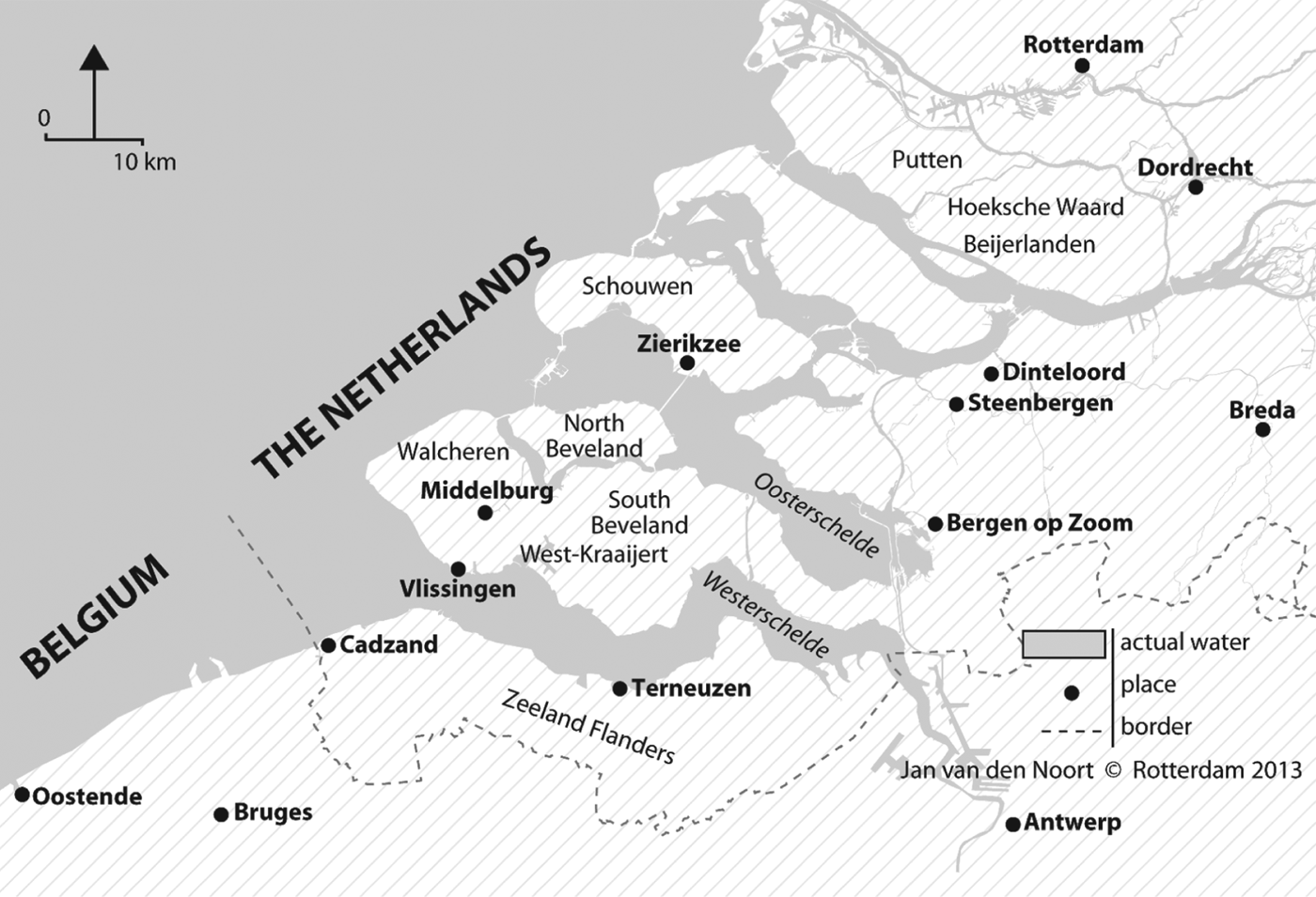
Today the research area has marine clay soils and, as shown in Figure 1, stretches some 320,000 hectares across the entire province of Zeeland, the Holland islands – which lie to the south of Rotterdam – and the north-western part of Brabant. It partly overlaps the coastal plain of Flanders, because Zeeland Flanders – nowadays the southernmost part of Zeeland – was a part of Flanders until 1600 or thereabouts, and was one of the fertile lowland areas along the southern North Sea coast which witnessed the rise of large-scale commercial agriculture from the later Middle Ages. Along with the Flemish coastal plain, the region was hit by catastrophic storm surges in the fifteenth and sixteenth centuries.Footnote 19 As both Thoen and Van Bavel have pointed out, in the Netherlands the formative period in which a region was reclaimed and settled could influence social property relations within that region over a long period, because the initial landownership structure would often demonstrate a strong resistance to change.Footnote 20 The history of the south-western, marine clay area is exceptional because over the period from about 1375 until 1570 half of the occupied area was flooded and had to be reclaimed again, a process that obliterated old structures and created completely new ones. This is the key to understanding why developments in the Middle Ages diverged so markedly from those in the Early Modern period. To demonstrate this, let us consider the late-Medieval floods and their consequences for property relations in the study area, before examining how the new property relations changed the economy and society of the area and how this, in turn, influenced both farming and investment in flood control.
The south-western Netherlands with present-day coastline and borders.

2. THE COLLAPSE OF WATER MANAGEMENT IN THE FIFTEENTH-SIXTEENTH CENTURIES
Apart from some ‘young’ polders with sea clay soils, which had been first embanked in the twelfth century, the south-west of the Netherlands in the late Middle Ages had mostly mediocre peat or peat on clay soils. When these soils were drained for use as arable farmland, the level of the land subsided through shrinkage and oxidation of the peat. This made the area vulnerable to flooding and obstructed the disposal of excess water, a situation that was made worse by the digging of peat for fuel and salt production,Footnote 21 both of which were often done outside the sea walls. If the foreshore became weakened by peat extraction, the dikes received the full impact of any storms and underwater currents. Where the land was protected from the sea by dunes, problems were often compounded if the dunes were eroded as a result of their over-exploitation as grazing for sheep and cattle or as rabbit warrens.Footnote 22
Often, the situation was exacerbated by political conflicts. The Grote Waard, an area of 53,000 hectares in southern Holland, suffered from peat digging and shrinkage of the soil and was heavily hit by the ‘Saint Elisabeth’ flood of 1421. Nevertheless, the area might have been saved if the regional lords had been able to reach an agreement about repairs. However, they failed to do so, and another flood in 1424 caused so much damage that 39,000 hectares had to be abandoned for decades, if not generations.Footnote 23 From the fourteenth century onwards many dikes and sluices were damaged as a result of war, either through a lack of maintenance because the population had fled or by deliberate destruction as part of military strategy, which occurred mainly during the Dutch Revolt against the Habsburgs. There were devastating inundations as a consequence of military action between 1583 and 1586, when the destruction of the flood defences was used by both the Dutch and Habsburg armies on a large scale in northern Flanders and around the town of Bergen op Zoom to obstruct the march of the enemy's troops.Footnote 24
Another problem that elevated the risk of flooding was the behaviour of large landowners who tried to keep the cost of maintaining the sea walls as low as possible, especially in periods when rents were low, as they were in the fifteenth century. Maintenance was then thus sometimes deficient and, when the costs of maintaining marshland became very high, some landowners abandoned their land. They were within their rights to do so and in such cases the land reverted to the sovereign (the Count of Holland, Zeeland or Flanders), who took on the burden of maintaining or repairing the sea walls. Some small owners were forced to give up the land they held because they really were unable to pay the maintenance costs; others – mainly large landowners – argued that the high costs meant that the land was no longer profitable and that this was why they had decided to get rid of it. Often even the Count was unable to raise enough capital to pay for the necessary maintenance and the result was a loss of land to the sea.Footnote 25
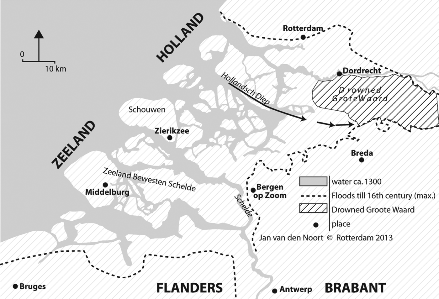
Dijkvallen (dike slidings) also contributed to the loss of land in the south-west Netherlands. A dike sliding was a collapse of part of a dike caused by deep gullies in the sea inlets that permitted the water to saturate the soil underlying the dikes. This subsoil, which was mostly composed of fine sand, changed into a liquid mass, which ‘slid’ into the gully, causing the dike on top of it to collapse. This phenomenon was first reported in the second half of the fourteenth century. From the fifteenth century dike slidings caused more and more damage.Footnote 26 Efficient means to prevent them did not exist and the less efficient methods employed by the water boards were very costly. Despite enormous investments, the polder of Schouwen, for instance, lost 3,000 hectares – a quarter of its land area – because of dike slidings (see Figure 2).Footnote 27 It is true that dike slidings seldom caused the flooding of large areas, but if they weakened a dike a storm surge might then breach it, allowing the sea in.
Flooded areas in south-western Netherlands, fifteenth and sixteenth centuries.
In combination, these factors led to a collapse of the flood defences in much of the study area. The sixteenth century was especially disaster-prone, with major floods in 1509, 1511, 1530, 1532, 1552 and 1570, followed by the military inundations of 1583–1586. It is difficult to gauge how much land was lost, but 100,000 hectares – about half of the previously occupied area – over the period between the late fourteenth to the late sixteenth centuries would probably be a conservative estimate (see Figure 2). At the time this was catastrophic for the rural population, but in the long run it had a very positive side effect. The rather poor peat soils were swept away by the waves and very fertile young marine clay was deposited in the area. Over several decades this created the basis of land that would be very valuable when it was reclaimed once again.
3. LANDOWNERSHIP BEFORE THE FLOODS
Sources concerning the distribution of landownership in the Middle Ages in the south-west Netherlands are scarce, but for the late fifteenth and the sixteenth century some information is available. Records from 1463–1464 and 1493 provide insight into patterns of landownership in Zeeland bewesten Schelde – today known as the islands of Walcheren and Noord- and Zuid-Beveland – an area of around 40,000 cultivated hectares. Here, the nobility and the Church together owned 15–20 per cent of the land and town-dwellers 20–30 per cent. Especially around the larger towns the latter often owned a considerable part of the land. Inhabitants of Middelburg owned 26 per cent of the land on Walcheren in 1463–1464 and in 1535 inhabitants of Zierikzee owned 36 per cent of the land comprising the polder of Schouwen, where the town was situated. However, most of the land, some 50–60 per cent, was still owned by peasants.Footnote 28 Property relations resembled those in adjacent Holland, where in the first half of the sixteenth century peasants owned about half of the cultivated land and townsmen 20 to 30 per cent, the nobility no more than 5 per cent and religious and charitable institutions some 10 per cent. On the islands to the north of Zeeland, which lay in the county of Holland, it is likely that a similar pattern prevailed, as land rates were only a small part of the annual income of even the most important noblemen in this area, while inhabitants of the city of Dordrecht owned a great deal of land, especially close to the city.Footnote 29
In the southernmost part of the research area, present-day Zeeland Flanders, property relations were somewhat different, mainly because the Church owned much more land in the area. There were wide variations between districts but, overall, around the middle of the sixteenth century, abbeys, churches and hospitals seem to have owned some 35–40 per cent of the agricultural land in this area.Footnote 30 The share owned by the nobility was small, but the amount of land owned by townsmen may have been of a similar magnitude as in Zeeland and Holland.Footnote 31 Consequently, the share held by the peasantry must have been smaller in Zeeland Flanders, perhaps some 30 per cent of the land. This is not surprising, since peasant landownership in other coastal areas of Flanders had been in decline since the late thirteenth century.Footnote 32
Both the Church and the peasantry lost land as a result of the floods in the fifteenth and sixteenth centuries. The losses suffered by the Church were very clear in north-east Flanders, once the stronghold of ecclesiastical landownership. In the district of Terneuzen the share of the land owned by religious institutions decreased from 31 per cent in the period before 1530 to only 4 per cent around 1560. This area had been severely hit by the floods of 1509, 1530 and 1532 and the costs of repairing the sea walls were very high. The abbots realised that the income from renting the land would not be sufficient to pay for the repairs and decided to abandon the land in their possession. Elsewhere in northern Flanders several abbeys, monasteries and hospitals also abandoned land because the costs they faced were higher than the income they received in rents. These institutions preferred to concentrate their possessions in inland Flanders, often in less fertile, but certainly less risk-prone areas.Footnote 33
The peasantry also lost land. Small peasants were seldom able to raise the money required to repair the dikes as quickly as required, and they therefore had little choice but to abandon their land. The same was true for well-to-do yeoman farmers who usually had their land concentrated on one polder; if the latter was submerged they lost most of their worldly goods. Sometimes they were able to pay for repairs after a flood, but if the area was hit again shortly afterwards, they often went bankrupt. This happened to several yeomen farmers from Zuid-Beveland; in the wake of the floods of 1530 and 1532 these formerly prominent men had to take menial jobs and lived in deep poverty.Footnote 34
In parts of Zeeland the land area owned by the nobility also decreased. The reaction of Joos van Cruyningen, one of the wealthiest Zeeland noblemen, was characteristic of the attitude of many noblemen to the flooding of the eastern part of the island of Zuid-Beveland in 1530. Although he owned several seigneuries on the island, he was not very interested in repairing the damage and boasted that he had many more possessions in Holland, Brabant and Namur than in Zeeland. Several other prominent aristocrats shared this view. It proved difficult to persuade them to support the local population's attempts to repair the dikes.Footnote 35 The Church, peasants, yeomen and some nobles lost land in the study area; the largest landowners because they sometimes deliberately gave it up in favour of land in less precarious areas, and other landowners because they could not meet the cost of repairing the dikes. The bourgeoisie were the winners; how they came to acquire greater amounts of land can be demonstrated by looking at the way both repairs and new reclamations were financed.
4. LANDOWNERSHIP IN RE-EMBANKED AND NEWLY RECLAIMED AREAS
Some flooded areas were drained shortly after they were inundated; others were only reclaimed after being submerged for decades. In both cases, however, large sums were required to drain the land. Since the nobility, the Church and the peasants were often either unwilling or unable to pay for the work to be undertaken, the urban bourgeoisie had to come to the rescue of the rural population. This happened, for instance, on the island of Zuid-Beveland. After the floods of 1530, 1532 and 1552 wealthy merchants and dignitaries from the cities of Antwerp and Malines invested in the drainage of land on the island which had been submerged, and even in the late sixteenth century they still owned a considerable proportion of the farmsteads and land on Zuid-Beveland.Footnote 36
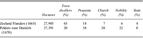
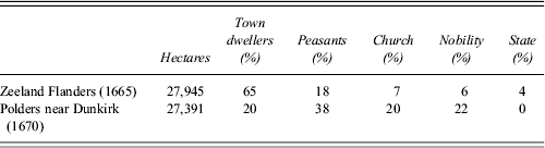
The consequences for the distribution of landownership in the south-west Netherlands were enormous, because of the vast tracts of land that were reclaimed. Between 1550 and 1700, 103,000 hectares of land were reclaimed from submerged areas as new polders.Footnote 37 These were in addition to the polders where the sea walls had been repaired shortly after the floods. Although no new landscape was created in the latter, the high costs of the repairs nevertheless resulted in shifts in the distribution of landownership because many smaller landowners were forced to abandon the land they had held.Footnote 38 The effect all of this had on property relations can be demonstrated by comparing two tax records from the seventeenth century. Table 1 shows the property relations in two areas of the Flanders coastal plain between 1665 and 1670. The two areas are Zeeland Flanders and the polder area around Dunkirk. Both share roughly the same history, apart from one factor: Zeeland Flanders had been flooded in the late Middle Ages and the sixteenth century and the Dunkirk polders had not.
Percentage distribution of landownership in two areas on the coastal plain of Flanders, 1665–1670
Sources: Nationaal Archief, The Hague, Raad van State 2145 I; P. Vandewalle, Quatre siècles d'agriculture dans la région de Dunkerque 1590–1990. Une étude statistique (Ghent, 1994), 137–43.
In the Dunkirk area in 1670, peasants were the most important group of landowners in terms of hectares held, although the nobility and the Church also had substantial possessions. Town-dwellers owned only a modest fifth of the land under cultivation. In the re-embanked polders of Zeeland Flanders, however, these townsmen had become the most important group of landowners by far, owning two-thirds of the land; at least twice as much as this group had owned in the first half of the sixteenth century. The rural population and the religious and charitable institutions had literally ‘lost ground’. The possessions of the Church were reduced from as much as 35–40 per cent of the land area around 1550 to only 7 per cent of the total by 1665. In Zeeland Flanders, the noblemen paid for the re-embankment of the land they had owned before the floods, but they did not enlarge their possessions; they were not among the entrepreneurs financing large drainage projects.
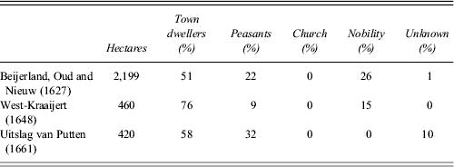
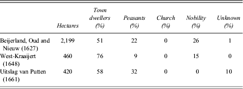
For the rest of the region no tax records comparable with those from Zeeland Flanders have survived for a large area after 1665. Records from different polders, however, present the same image of the distribution of landownership. Table 2 shows that those owning land on the polders were predominantly from the towns and indicates that these townsmen were the most important group of landowners in each region. Religious and charitable institutions had not disappeared as completely as Table 2 suggests, as they still owned some land on polders not shown in the table. What happened to a collegiate chapter on the island of Putten may serve as an example of the history of many ecclesiastical landowners in the area. After the flood of 1570, the chapter had to sell part of its land in order to be able to pay for the re-embankment of the remainder. Shortly afterwards, the new Calvinist rulers of Holland secularised the chapter's possessions as it did those of many other institutions. The secularised land became property of the province, which later often sold it. The Reformed Church still owned land, but on a very limited scale.Footnote 39 The Church could thus no longer be considered a potential investor in land reclamation.
Percentage distribution of landownership on polders in Zeeland and on the South Holland islands, 1627–1661
Sources: C. Baars, De geschiedenis van de landbouw in de Beijerlanden (Wageningen, 1973), appendices 1 and 9; Zeeuws Archief, Middelburg, West Kraaijertpolder 27; Streekarchief Voorne-Putten en Rozenburg, Brielle, Polder Oude en Nieuwe Uitslag van Putten 70.
On some polders in Holland and Zeeland, noblemen owned a considerable share of the land. Sometimes, in contrast to the nobles of Zeeland Flanders, they also had substantial shares in the drainage companies. These noble investors were seldom from Holland or Zeeland, however; they lived in the central provinces of Utrecht and Guelders or in the southern Netherlands.Footnote 40 In the seventeenth century the south-west of the Netherlands had virtually no resident nobility left. Local noble families had become impoverished or extinct or had moved to other provinces in the northern and southern Netherlands. Those who still possessed seigneuries often held the rights to embank their foreshores but, because of a lack of capital, they usually preferred to sell these foreshores to investors. In these transactions the investors were granted ownership of the land, while the noble retained his seigneurial rights to the reclaimed land and to the new foreshore. Even the House of Orange, the most powerful noble family in the Dutch Republic, who owned the important seigneuries of Steenbergen and Breda, usually relied on urban investors to drain its marshes.Footnote 41 The nobility as a whole seem to have maintained their standing, but they had become absentee landlords, and entrepreneurship and capital for drainage had to come from the cities.
Some historians tend to equate the ownership of rural land by men from the urban areas with ownership of large tracts of land.Footnote 42 As Peter Hoppenbrouwers has pointed out, this is not quite correct.Footnote 43 Most urban landlords owned less than 50 hectares in the rural areas. On the Beijerlanden polders around 1630, 18 burghers from Dordrecht, who belonged to the wealthy elite of that important city, owned 365 hectares between them. None of them owned more than 40 hectares.Footnote 44 Hardly any city dweller owned more than 1,000 hectares of rural land and the possessions of those who owned several hundreds of hectares could be spread over several polders, so that large, concentrated landholdings were very rare.Footnote 45
Table 2 shows that, in Zeeland and the South Holland islands, peasant landownership increased as time passed. The tax record from the polder of Uitslag van Putten, dated 1661 – more than a century after the polder was drained in 1558 – shows that farmers owned the largest share of the land on the polder. The 1648 tax record from West-Kraaijert was, however, drafted only six years after drainage had occurred in 1642 and shows farmers owning little land. Immediately after drainage, all of the land comprising a new polder was the property of those who had invested in the drainage. In the short run some investors sold their land, but most kept it.Footnote 46 However, over the course of time, plots of land were sold, often due to the partition of an inheritance. Some of this land was sold to successful tenant farmers and in the eighteenth century a class of yeomen farmers emerged. They purchased even more land after 1750, when the prices of agricultural products increased.Footnote 47
5. CHANGES IN ECONOMY AND SOCIETY
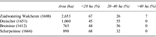
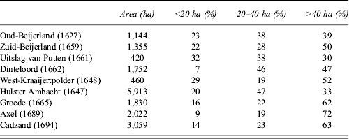
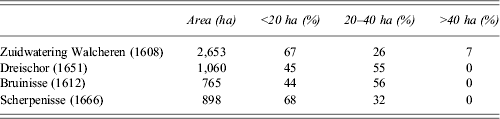
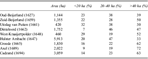
Re-embankment of the polders not only had consequences for landownership, but also for the size of landholdings. Tables 3 and 4 show that a considerable difference in holding size existed between the medieval polders and those embanked or re-embanked from the 1530s onwards. On the medieval polders, smaller holdings that could function with just family labour were still very important, covering 44–68 per cent of the cultivated area, whereas on the ‘younger’ polders such holdings took up 32 per cent of the land at most and usually much less. Very large holdings of 40 hectares or more, which could only be exploited with large numbers of wage labourers, were virtually absent from the older polders, but covered a considerable part of the land in the newer ones. Soil conditions can partly explain this difference. On some of the older polders, there was a lot of low lying land that was difficult to drain and therefore could not be used as arable land, precluding the rise of commercially viable arable farms.Footnote 48 This was not the case on all medieval polders, however, so other factors must have played a part in constraining the type of farming practised.
Percentage distribution of agricultural land between small (less than 20 hectares), middling (20–40 hectares) and large (more than 40 hectares) holdings on four polders that were not flooded in the late Middle Ages, at selected dates in the seventeenth century
Sources: P. Priester, Geschiedenis van de Zeeuwse landbouw circa 1600–1910 (Wageningen, 1998), 700–3.
Percentage distribution of agricultural land between small, middling and large holdings on nine polders that were (re)embanked after 1550, at selected dates in the seventeenth century
Sources: P. Priester, Geschiedenis van de Zeeuwse landbouw circa 1600–1910 (Wageningen, 1998), 704; C. Baars, De geschiedenis van de landbouw in de Beijerlanden (Wageningen, 1973), appendices 2 and 18; Zeeuws Archief, Middelburg, Vrije van Sluis 498, 507; West-Kraaijertpolder 27; Gemeentearchief Terneuzen, Oud Archief Axel 662; A. Hallema, Geschiedenis van de gemeente Dinteloord en Prinsenland in de zeventiende eeuw (Dinteloord, 1955); Streekarchief Voorne-Putten en Rozenburg, Brielle, Polder Oude en Nieuwe Uitslag van Putten 70.
The rise of large commercial farms was not entirely new in the study area. In northern Flanders it had already begun in the fifteenth century, but progressed relatively slowly.Footnote 49 The floods of the fifteenth and sixteenth centuries and the resulting revolution in property relations gave the process an enormous boost. Landowners from the urban areas hardly ever exploited their land themselves but leased it to tenant farmers. The largest landlords often leased out their land in large units, but this was not general practice. On the polder of Zuid-Beijerland in 1659, for example, two burghers from the city of Dordrecht let their land; one, with a plot of 48 hectares, let it as one large unit, while the other let his 20 hectares to five different tenants.Footnote 50 Furthermore, as already mentioned in the previous section, most landowners from the towns did not own rural land on a large scale. The rise of large farms in this area was not entirely the result of a policy by the large landowners. Of the 12 farms of more than 40 hectares in Zuid-Beijerland in 1659, only two had just one owner. The other 10 were formed out of plots owned by two or more individuals; one farmer cultivated almost 95 hectares leased from seven urban landlords.Footnote 51 The same can be observed on other polders. So in many cases large commercial arable farms were not created by large landowners from the towns, but by enterprising farmers. In the south-western Netherlands ‘capitalism from below’ emerged, as it did in the coastal area of the Wadden Sea in the northern Netherlands and Germany, the Guelders river area in the centre of the Netherlands, parts of eastern England and in the Ile-de-France where, again, engrossment was driven mostly by farmers, not by landlords.Footnote 52
By itself the ownership of rural land by the urban elite was not the cause of the rise of large holdings; it had to work in combination with the lively land and lease market that had emerged.Footnote 53 Land was a commodity that could be sold, or let, in larger or smaller units, by the urban landowners when required. The relatively small size of many of the plots owned by those from the towns contributed to the fluidity of the market. The plots were let individually for periods of three to seven years. Tenant farmers could accumulate tenancies, purchase land or do both. As in north-west Germany and in the Guelders river area, successful tenant farmers pushed the smaller farmers out.Footnote 54 Thus it can be seen that it was not only the attitude of the owners that was important to the land market, but also that of their tenants. In order to succeed under the difficult circumstances on newly reclaimed land, tenants needed capital and entrepreneurial skills.
One by-product of the changes in property relations and holding size was an increase in social inequality, but we must consider whether the consequences of such a change were really as negative as Soens and Van Bavel supposed. Is there any evidence to support the contention that a peasant society, capable of providing a living to a large number of people, was destroyed and replaced by a society where any benefits were reaped by only a few large farmers and landowners? At first sight, this contention would appear to be true. In the new polders most land was cultivated by large farmers and some 60 per cent of the population were labourers, about the same level as in the Guelders river area with its large-scale commercial agriculture.Footnote 55 On the other hand, population density in Zeeland and Zeeland Flanders was relatively high. In 1680, there were 42 persons per square kilometre of land in rural Zeeland, and there were 44 persons per square kilometre in Zeeland Flanders in 1698.Footnote 56 There were thus fewer persons per square kilometre than the 60 or more found in the peasant areas of inland Flanders, but considerably more than the 25 found in the Guelders river area.Footnote 57
This relatively high population density was the result of the fact that large-scale commercial agriculture in our study area was labour intensive. Farmers took great care to keep the fertility of the soil intact by implementing a well-balanced crop rotation, in which cereals were alternated with nitrogen-fixing legumes. The land was also carefully and intensively ploughed, harrowed and weeded. In particular, a great deal of work was spent on the main cash crops: wheat and madder.Footnote 58 So much labour was required that the local labour force was not sufficient and in spring and summer seasonal labourers from inland Flanders, Brabant and even Hainault and Germany came in large numbers to Zeeland, Zeeland Flanders and the South Holland islands, especially to help with weeding and the harvest.Footnote 59 Widespread poverty did not occur amongst labourers in the south-western Netherlands. Many of them had employment the year round and several were actually smallholders, cultivating a small amount of land and owning one or two cows. They supplemented their income by working for the large farmers or by doing maintenance work for the local water boards. As in the Wadden Sea area, poverty did not increase until the late eighteenth century, when population growth accelerated.Footnote 60
Although soil fertility on some new polders seems to have declined over the first century after drainage, crop yields were nevertheless generally high and remained so well into the nineteenth century. An old contention, that agriculture in the area was backward and actually depleted the soil, has been disproved by recent research.Footnote 61 Around 1800, average wheat yields in most of the study region were 20 to 25 hectolitres per hectare. In Zeeland, which probably had the highest land productivity of all the Dutch provinces at that time,Footnote 62 social inequality and large-scale commercial farming did not lead to either widespread poverty or soil depletion. High and stable levels of land productivity meant that the economic means to maintain the drains, sluices and sea walls remained intact. Indeed, when trade and shipping in Zeeland collapsed after 1795, the region's highly productive agriculture became the mainstay of the local economy.Footnote 63
Agriculture in the south-western Netherlands was labour intensive, unlike other areas with large-scale commercial agriculture, such as the Guelders river area, but the availability of cheap seasonal labour was not the reason for this. In the Guelders river area such labour was also available. The distance to the urban markets of Holland cannot explain the difference either, as both areas had excellent connections to the cities of that county. The real reason was the difference in soil conditions between the two areas. In the south-west the marine clay soil was very fertile and well-drained; up to 85 per cent of it could be used for highly productive arable farming. In the river area, however, the clay soils were heavy and badly drained and could only be used as meadowland. Where there were lighter and more fertile soils that might be used as arable land, these were found to have drainage problems because of the seepage of water from the rivers. The seepage caused high ground water levels in early spring, which led to the land becoming heavily infested with weeds. The intensive weeding and harrowing practised in the south-west would have been an uphill battle in such conditions. Farmers in the Guelders river area recognised that the labour costs involved in weeding would never be repaid by sufficiently higher yields. In the south-west, on the other hand, farmers knew that high yields would recompense them for their high labour costs.Footnote 64 The soil conditions thus explain why agriculture in the south-western Netherlands developed differently from that in the Guelders river area, and once again highlight the importance of the change of soil following the floods. When fertile clay replaced the poor peat soil, this made it possible to switch from peasant agriculture, which was mostly, although not exclusively, for subsistence, to commercial arable farming, and from growing rye and barley to more valuable wheat and madder.Footnote 65 In addition, the high yields from the new soil made it feasible for farmers to invest in the maintenance of the fertility of that soil. We thus agree with van Dam that a change of soil can be an agent of historical change.
6. INVESTMENT IN FLOOD CONTROL
Whereas the Middle Ages ended in catastrophic floods, from the seventeenth century onward 90 per cent of the reclaimed land was no longer subject to flooding and if a flood did occur, the damage was quickly repaired. This difference was not caused by technological change, as all the methods used to protect dikes in the early modern period were already known in the late Middle Ages. Recent research by Soens has attributed the failure of the medieval water boards to maintain the sea defences to a large degree to the income strategies adopted by absentee urban landowners who refused to invest in the maintenance and improvement of the dikes. However, after 1600 the ownership of rural land by town dwellers became even more predominant in the region without fatal consequences for investment in water management. Why were seventeenth- and eighteenth-century urban landowners prepared to invest heavily into water management, whereas their medieval predecessors had refused to do so?
First, it should be recognised that the post-medieval water boards stood on a stronger financial footing because by then the quality of the soil was generally much better. The new marine clay provided higher yields, higher rents and more capital for dike maintenance than the poor peat soils of the Middle Ages. Since the farming system used in the region did not, in general, deplete the soil, the fertility of the latter has remained intact, even until the present day. The main answer as to why the post-medieval landowners were more prepared to invest in flood defences, however, was that these new large landowners belonged to a different social group from the old ones. Many of the late medieval large landowners were religious and charitable institutions or noblemen. They were interested in maintaining a steady stream of income in order to support their institution or their lifestyle. When, because of floods or dike slidings, the cost of maintenance of the dikes became higher than the income received from renting the land, from their viewpoint it was rational to abandon the land. They did not aim to maximise their profits and were, for the most part, risk-averse. All examples we know of large landowners abandoning their land, or being unwilling to invest in improvement or repair, belonged to these groups, especially Flemish abbeys and Zeeland noblemen.Footnote 66 Even those abbeys and hospitals whose possessions in the coastal polders remained profitable often chose to invest any profits they made in land in less risk-prone regions. An additional reason for some institutions trying to dispose of their land in the coastal area was that they had leased it out for a very long term – sometimes even in perpetuity – and for a fixed money rent. This guaranteed a steady stream of income but in a period of inflation, such as the sixteenth century, this stream would have been reduced to a trickle.Footnote 67
As Tables 1 and 2 show, the Church and charitable institutions had almost disappeared as landowners by the seventeenth century. The vast majority of the new large landowners were town-dwellers.Footnote 68 There were urban, provincial and federal officials among them, but merchants were especially well represented. They were entrepreneurs who traded in the North Sea area, the Baltic, the Caribbean and the Wild Coast of South America, financed privateering and had shares in the East and West India Companies. They also invested in land reclamation.Footnote 69 The Lampsins brothers, successful merchants from Vlissingen, invested in polders in Zeeland Flanders, but also tried to colonise the island of Tobago in the Caribbean in 1654. The officials too were often entrepreneurs because the economic and political elites still formed one social group in the seventeenth century. Jacob Boreel, Master of Zeeland Mint and mayor of Middelburg, invested in shipping, in the Dutch East India Company and also, from 1595, in several drainage projects in Zeeland Flanders.Footnote 70 Trade and shipping carried large risks and could take a long time to become profitable, but merchants knew that their profits could eventually be large. Compared with the risks involved in such enterprises, the risks associated with investing in drainage were limited, and investors could minimise what risks there were by taking shares in several drainage projects.
The entrepreneurial attitude of the new urban landowners and of the farmers seems to have been one of the keys to successful water management in the seventeenth century. Unlike their medieval counterparts, these groups were willing to risk large investments in the hope of profit. During the first half of the eighteenth century, when the agricultural depression was at its worst, some of the landlords despaired and sold their land. Despite the difficulties of this period they chose to sell rather than to abandon the land. The yeomen farmers who purchased most of the land were willing to invest in maintenance of the flood defences.Footnote 71 Moreover, those urban landowners who held on to their land were prepared to share the burden of maintenance of the dikes, even if that burden became heavy. For instance, when the water board of Cadzand in Zeeland Flanders decided that they would have to raise their annual budget from 14,000 to 54,000 guilders after the storm surge of 1715, the urban landowners agreed. Some of the latter were even prepared to support the board's work by lobbying for tax reductions in The Hague.Footnote 72
Urban landowners could easily lobby either the provincial or the federal governments because there were close ties between the economic and political elites in the Dutch Republic. Officials from the powerful cities dominated the provincial governments,Footnote 73 and were also often landowners themselves, so requests for support of the polders that were at risk of flooding had a good chance of being granted. This caused an important change in state policy. Until about 1500, the counts of Holland, Zeeland and Flanders did not offer support to the water boards of polders that were confronted with exceptionally high maintenance or repair costs and later in the sixteenth century the Habsburg kings only did so when they perceived that it would be in their own interest.Footnote 74 From the late seventeenth century, it became general practice that ‘calamitous’ polders, as they were called, received state support. This took the form of exemption from certain taxes to landowners and farmers on the polders, usually on condition that the water board of the polder would spend the amount of the exempted taxes on dike maintenance.Footnote 75
This state policy became ever more important as the number of dike slidings increased, especially along the shores of the Ooster- and Westerschelde rivers. Effective means to stop this phenomenon were only introduced in the nineteenth century. Until then, large sums had to be invested each year to prevent further erosion of the shoreline polders. The number of requests for state support of these efforts kept increasing and these requests were usually granted. Around 1770 the support of ‘calamitous’ polders cost the small province of Zeeland some 200,000 guilders annually, exacerbating the already large financial problems of the province, so that a report of the Stadholder (the de facto head of state of the Republic) from 1767 called the subsidies ‘the cancer of the Zeeland finances’.Footnote 76 The burden of maintenance was thus partially shifted from the landowners to the state. Urban landlords could do this because they controlled the state. The same happened in Holland and the territories under the sovereignty of the Estates-General, or Dutch Parliament.Footnote 77 Of course, this was a clear case of powerful elite groups furthering their own interests at a cost to the taxpayers. In this case, however, the lack of social balance did not have pernicious consequences because the interests of the urban elite coincided with those of the rural population, as both benefited from continued investment in the sea defences.
7. CONCLUSION
The most conspicuous change caused by the late medieval and sixteenth-century floods in the coastal region of the south-western Netherlands was the rise of ownership of land in this rural area by men from the towns. Peasants, yeomen, abbeys, hospitals and, in some areas, noblemen too were often unable and sometimes unwilling to pay for reclamation of flooded land, but urban capitalists had the money and were prepared to take the risk of investing in drainage projects. Ownership of vast tracts of fertile land was their reward. Thus, in the sixteenth and seventeenth centuries, a revolutionary change in landownership occurred in the region, with far-reaching consequences for local farming and social structure. In the newly drained polders, and in older polders where the urban landowners had acquired considerable amounts of land, large commercial arable farms, mostly run by tenants, became the norm. In these areas, some 80 per cent of agricultural land belonged to holdings of 20 hectares or more, whereas in older polders such farms held just half of the land at most. This resulted in a socially polarised rural society dominated by a small group of large commercial farmers who employed a large number of wage labourers. Contrary to the views of Van Bavel and Soens, this did not lead to widespread poverty or ecological deterioration. Farming in the region remained relatively labour intensive, thus securing a reasonable income for the lower strata of rural society, and at the same time guaranteeing high crop yields over a period of two centuries or more.
Important for the success of the post-medieval water boards in maintaining the land, versus the failure of the medieval water boards, was the rise of a new type of urban landowner. These entrepreneurs were used to investing large sums in risky activities such as trade, shipping and privateering. The former landowners had been abbeys, hospitals and noblemen with risk-averse attitudes. They wanted nothing more than a steady source of income to finance their institution or their lifestyle. When the land no longer provided this, they abandoned it. Urban entrepreneurs, however, were prepared to invest in polders that were at risk of being flooded as long as they saw a reasonable chance that their investment would pay off in the future. Although some descendants of the investors later sold part of the land to successful farmers, the remaining urban landlords were still willing to invest substantially in order to maintain the flood defences. It has to be admitted that this willingness was almost certainly stimulated by the fact that, because the urban elites held political control, they were able to reduce their costs by arranging for the state to subsidise ‘calamitous’ polders by granting them tax exemptions, thus shifting the burden of maintenance partially to the taxpayer. The lack of social balance was not an obstacle to sustainable management of these reclaimed wetlands. One might even say the reverse was true: the concentration of political power and wealth into the hands of urban elites contributed strongly to the upkeep of the sea defences.
Another important contribution to the success of the society and economy in the coastal region was made by the farmers. Not only did they preserve soil fertility and provide work for a substantial labour force, but also more than the urban landlords they were responsible for the rise of large-scale commercial farming through the accumulation of tenancies and the purchase of land. Furthermore, even when economic and environmental circumstances deteriorated in the eighteenth century, the farmers bought land from the urban landlords and continued to invest in the maintenance of the sea walls. On their own they might not have managed to save the land, but their efforts, in combination with those of the urban landlords who lobbied for state subsidies to be granted, were sufficient to guarantee the preservation of most of the drained land.
A coalition between prosperous and enterprising farmers and urban landlords with political power was the basis of maintaining the south-western Netherlands' fertile but also fragile coastal area. This once again underlines how important it is to take property relations into account when investigating the development of a rural economy. However, in this case farmers and landlords would not have succeeded without the fertile and well-drained soil that had come to the surface after re-embankment of the areas that had been flooded in the late Medieval period. This soil made the labour-intensive and sustainable agriculture feasible and this, in turn, formed the economic basis that meant that landlords and farmers could successfully preserve the land. Thus, while the ‘social agrosystem’ approach to the historiography of the rural areas of the Low Countries, which focuses on property relations and power, is a fruitful one, it is wise not to dismiss the contribution of other factors such as market conditions and soil quality.
ACKNOWLEDGEMENTS
The research for this article was funded by the Netherlands Organisation for Scientific Research (NWO). The author would like to thank Petra van Dam, Heleen Kole, Maarten Prak and Milja van Tielhof for their comments on earlier drafts of this paper.