BERKSHIRE
(1) Bracknell, land at Tilehurst Lane, Binfield, (SU 8955 6995): a small excavationFootnote 130 revealed an urned Late Iron Age cremation burial, in a vase-like grog-tempered vessel, which produced a radiocarbon date of 52 cal b.c.–cal a.d. 78 (UBA 45941). The burnt bones were probably those of an adult but analysis revealed nothing else.
EAST SUSSEX
(1) Ringmer, Bridge Farm, Wellingham, (TQ 430 144): the tenth season of investigationsFootnote 131 saw a return to Trench 7 originally opened in 2018.Footnote 132 The clay and chalk feature recorded thenFootnote 133 was revealed to be a deposit at the edge of a deep multi-layered ovoid pit (F38A), which included deposits of burnt clay, suggesting high-temperature industrial activity. The upper fill included plain tile tesserae as previously found in the surrounding area. The pit was joined at one end by another deep pit, possibly suggesting a kiln and firepit combination, but this has yet to be substantiated by further excavation in 2022. A further 11,032 sherds of pottery were collected, giving a total of 39,507 sherds from just this 900 m2 area. 156 kg of ceramic building material including 1,500 tesserae and 197 kg of burnt clay were also recorded.
KENT
(1) Burham, land at Bell Lane (TQ 72746 61916): an evaluationFootnote 134 revealed several features apportioned to the late Iron Age to early Roman ‘transition’ period, dating from around 100 b.c. to a.d. 100. These included a series of boundary ditches, possible remnants of light structures consisting of post-holes and pits, and a re-cut of a late Bronze Age boundary ditch. Eccles-type (a.d. 50–80) brick and tile fragments were found in the fills of ditches and pits.
(2) Chatham, Chatham Interface land (TQ 76094 69720): an evaluationFootnote 135 uncovered evidence of Roman activity confined to a single trench. A large enclosure or drainage ditch had a narrower drainage ditch running parallel to it. Two pits/post-holes were observed to the south of both ditches. A small assemblage of pottery dated to the early Roman period and a fragment of abraded Eccles brick were recovered from the features.
(3) Herne Bay, land south of Greenhill Road (TR 16001 66336): two phases of Roman activity, concentrated in the northern and central parts of the site, were encountered during a large-scale evaluation.Footnote 136 The early features were attributed to the first century a.d. and notably included two cremation burials. Series of pits, post-holes and ditches of similar date were also observed. Many of the confirmed features were precisely correlated with geophysical anomalies recorded during a prior geophysical survey, possibly indicating the presence of a settlement/building with an associated field system. The later phase of activity dated to the second century onwards and was represented by linear cuts, pits and post-holes. These remains may suggest a heavily worked farm settlement or homestead. Further site investigations are ongoing in 2022.
(4) Kemsing, replacement Church Hall (TQ 5556 5878): excavationFootnote 137 within the footprint of the new building revealed traces of a late Roman settlement, probably dating from the fourth century a.d., confirming the results of an earlier evaluation of the site. The finds suggest that the settlement may have been relatively high-status, and it is possible that a masonry building would once have stood in the vicinity.
(5) Rainham, 4, 16, 20 and 22 High St (TQ 81396 66026): an excavationFootnote 138 was undertaken following earlier phases of work, revealing three ring ditches (probable ploughed out burial mounds). A Roman coin was recovered from the fill of one of the ditches. The south-west part of the site contained individual pits, a large intercutting pit group and post-holes, mainly thought to be of Iron Age and Roman date. The pits were indicative of grain storage and possible quarrying of the natural brickearth deposits, being re-used for the dumping of domestic and industrial waste at a later date. The arrangements of the post-holes within this area suggested the presence of at least two roundhouses. Post-excavation work is ongoing.
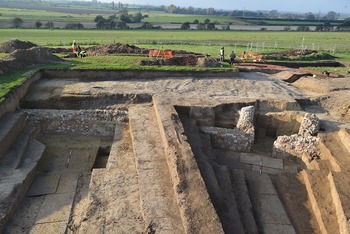
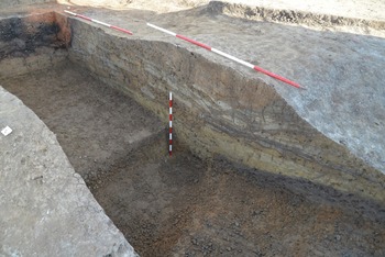
(6) Richborough (Rutupiae), amphitheatre (TR 324 602): excavationFootnote 139 took place on the amphitheatre, last examined by William Rolfe in 1849.Footnote 140 A part of the arena wall and a carcer, situated on the end of the short axis of the arena, were found to be extremely well preserved with walls standing 1.5–2 m in height (Fig. 45). These were buried by a thick colluvial deposit comprising the slumped material of the seating bank. The walls were built of chalk and flint blocks, rendered over with plaster. The plaster was painted in a scheme of vertical stripes in red and black, dividing decorated panels. The outer wall of the amphitheatre was a turf construction 6 m thick (Fig. 46). Timber structures cut into the back of this turfwork were burnt, causing the turf to be singed. The construction of these structures had a terminus post quem provided by a Carausian coin. Behind the amphitheatre an area of ditches and pits containing large quantities of animal bone was dated by copious coin finds to the very late fourth century. Further work on the Claudian gateFootnote 141 attempted to locate the south-western post-pit. This had been totally eradicated by an Antonine cess- or rubbish-pit, which was excavated.
Richborough: the amphitheatre arena wall and carcer viewed from the arena. (© Historic England)

Richborough: section through the turf construction of the outer wall of the amphitheatre. (© Historic England)

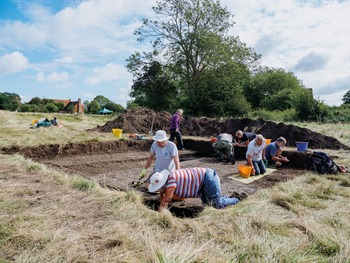
(7) Smallhythe Place, Tenterden, (TQ 89345 29995): seven trenchesFootnote 142 comprising a total of approximately 74 m2, along with 18 auger holes, were excavated in the garden of Smallhythe Place and the adjacent Forstal and Elfwick fields (Fig. 47). Three of those trenches (located in the westernmost part of the property) revealed evidence for Roman activity at the site. Small quantities of Roman material had previously been found at Smallhythe during a watching brief in 2006Footnote 143 and as surface finds recovered during geophysical surveys in 2019.Footnote 144 The 2021 excavations revealed evidence for a small settlement, represented by two phases of robbed-out building, a possible inhumation, and routeway and boundary features, in use from the later first to the later third centuries a.d. Together with its location to the north of the Isle of Oxney and alongside a channel of the River Rother (or Limen), and the evidence from the assemblages of ceramics, building material and metal-working waste recovered, it appears that the settlement was operating as a small-scale industrial and provisioning site associated with the supply, probably of iron and/or timber, for the Classis Britannica. Further excavation is planned during 2022 to refine our understanding of the site.
Excavation at Smallhythe Place (© National Trust/Sam Milling)

SURREY
(1) Tongham, land at Poyle Road (SU 89307 49338): a strip, map and sample projectFootnote 145 revealed a series of pits and ditches from which Romano-British pottery, dated to mid–late first century a.d., was recovered, primarily Alice Holt wares. Fragments of nine triangular clay weights were also found, along with possible kiln furniture which could indicate a kiln in the vicinity of the excavated area; however, this remains a speculation.
WEST SUSSEX
(1) Steyning, land north of Kings Barn Lane (TQ 18488 11547): an evaluationFootnote 146 revealed a series of pits and ditches in the centre of the site dated to the Late Iron Age to Early Roman period. Both local Sussex Wares and imported Gallo-Belgic wares, including Terra Nigra thought to be pre-conquest. A possible Roman ballista bolt head was also recovered, dated to the mid-first century a.d. The presence of pre-conquest Gallo-Belgic imports on this site suggests that it is one of high social status during the Late Iron Age, with a Roman military presence also possible in the area.
SUPPLEMENTARY MATERIAL
None submitted