


In 2010, a new London high-rise complex opened its doors near Tottenham Court station. Designed by Italian architect, Renzo Piano, the site was a shrine to twenty-first century hipsterdom. The airy piazza offered carefully selected gastro-fare from a range of up-scale eateries: Brazilian barbecue, South East Asian coffee and seasonal food served in compostable packaging for the eco-aware.Footnote 1 Several storeys up was one of the offices of search engine giant Google, replete with its quirky spaces, and well-paid urban professionals. It was a space free from signs of want, and an end point in a long journey towards respectability that started at the lowest point of London's history.
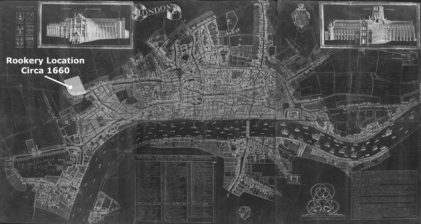
Back down on the ground and 250 years earlier, this plot of land was the site of the ‘Rookery’ – the most notorious set of mean streets London had ever known (Figure 1). Located in the parish of St Giles-in-the-Fields, it was an alleged rabbit warren of tangled passageways.Footnote 2 The area developed a uniquely fierce reputation for poverty and vice.Footnote 3 St Giles was, according to Robert Shoemaker, the London parish with the highest recorded rate of petty offences in the eighteenth century – a proxy measurement of wealth inequality and tension within a community.Footnote 4 The site also stood out as a local anomaly for its levels of poverty. Looking a century later in 1843, David Green and Alan Parton's analysis of poor rate books highlighted the streets of the Rookery as the neighbourhood in St Giles most reliant upon relief.Footnote 5 In other words, St Giles was unique within London, and the Rookery was unique within St Giles. Starting from H.J. Dyos’ 1967 query: ‘Why did this street become a slum and not that one’?, this article asks why there, why then and why for so long?Footnote 6 What factors enabled or even encouraged its development? And why did it take more than a century for London to decide it had had enough?
Annotated detail of W. Faithorne, An Exact Delineation of the Cities of London and Westminster and the Suburbs Thereof, Together Wth. Ye Burrough of Southwark (1658).
The Rookery was a relatively small but important space in London. It took several centuries to fall into disrepute following building work in the early modern era. By the eighteenth century, it was a slum as fundamental to the Irish migration story as Brick Lane was to Jewish and Asian ones. The site strikes its strongest emotional chord in the eighteenth century, playing out the conditions set in earlier decades and that must necessarily be told as part of a longer story. It is also an incredibly well-studied space, understood already through a range of disciplinary lenses, from art history, to archaeology, to social and cultural history. Its boundaries have been mapped and remapped, its soil sifted and its paper trail carefully perused. Yet no satisfactory explanation for the site's decline has yet been put forth, nor do we understand what risk factors it may have faced that were repeated or overcome elsewhere. Its story is part of both a local saga, but also a broader one linked to urban development and decline, and acts as a counter-point to Donald Olsen's extensive nineteenth-century-focused history of the adjacent and very well-documented Bedford Estate, which avoided the same fate as the Rookery despite its proximity in both space and time.Footnote 7
This article builds upon three multi-disciplinary traditions of scholarship that frame St Giles’ Rookery and spaces like it in particular ways. The first is as a transplanted Irish space, standing in as an imagined metaphor for Irish poverty and vice.Footnote 8 Interest in the Irish in London grew with the publication of Lynn Hollen Lees’ Exiles of Erin (1979), which inspired a number of further studies.Footnote 9 That body of work was not about the Rookery of St Giles, but because the neighbourhood had a large poor Irish population, it was used as a trope of the Irish experience at its most extreme. Much of the research in that tradition was grounded in a social scientific and demographic approach towards Georgian and Victorian reports and statistical studies. These included Frederick Eden's The State of the Poor (1797), Matthew Martin's Report on the State of Mendicity in the Metropolis, Thomas Augustine Finnegan's 1816 report on Irish people in the parish, and a later report of the London Statistical Society that considered the points of origin of the various Irish communities who settled thereabouts. Between them, these reports told us that there were 2,000 Irish poor in the parish in 1797; 9,000 by 1816. A majority had come originally from Cork but the nineteenth-century population was substantially the London-born offspring of immigrants.Footnote 10 These impersonal approaches to counting the Irish were supplemented by contemporary stereotype-reinforcing accounts from the English perspective. In 1749, Henry Fielding wrote that St Giles was known for ‘the hordes of Irish who annually seem to come in and go out with the flies and the fruit’.Footnote 11 Henry Mayhew perpetuated similar stereotypes a century later, interviewing an innkeeper who remarked, ‘I had rather have twenty poor Englishmen drunk in my tap-room than a couple of poor Irishmen. They'll quarrel with anybody the Irish will – and sometimes clear the room.’Footnote 12 This Irish commentary often painted the Irish as ‘others’ occupying a London neighbourhood only begrudgingly offered by the locals and obviously in need of moral and structural reform to align with bourgeois sensibilities.Footnote 13
This view of the space as Irish sits alongside but too rarely interacts meaningfully with another key vein of historiography, which approaches the area from a London-centric local governance perspective. Much of this work focuses on the Victorian era, looking at the results of slumdom and attempts to deal with it rather than the causes of it, considering the role (and often failing) of local government and the local elite in their responsibilities towards the poor. It tended to make heavy use of the records of the parish vestry, workhouse and watch, and included nineteenth-century work by ex-parish overseer Rowland Dobie (1829) who wanted to highlight the abuses of his fellow local government officials in their approach to disseminating poor relief.Footnote 14
The conversation has since evolved, including reflections on filth and the role of the Metropolitan Commission of Sewers in the nineteenth century, David Green and Alan Parton's work on the poor law and St Giles, Sarah Wise's research into the rise and fall of the Victorian-era Old Nichol slum in East London, Geoffrey Tyack's article on the failed attempts to improve the area by driving New Oxford Street through it and Tim Hitchcock's analysis of failings in the local workhouse in St Giles in the 1720s, which also pointed to the negative local impacts of the Commission for Building Fifty New Churches on St Giles's poor. In that latter work, Hitchcock argued the commission made decisions that protected wealthy locals from some of the burdens of financially supporting the local poor by splitting the parish in two (St Giles and St George Bloomsbury) with the aim of benefiting the rich taxpayers by exempting them from contributing to the poor rates of St Giles. The ploy ultimately failed, with St George never fully extracting itself from that responsibility, but the move did lead to long-standing tension and may have contributed to the corruption Dobie identified.Footnote 15 This body of research has made plain the importance of lax poor relief scrutiny as a reason why St Giles's Rookery attracted poor people for as long as it did, but does not acknowledge the fact that the Rookery was but a corner of St Giles, not the entire parish.
The final thread in the historiography considers the Rookery as a physical site developed by a series of social and geographical systems that enabled building work and land use in urban spaces. This began with the Survey of London, whose two volumes on St Giles were published between 1912 and 1914.Footnote 16 These volumes delve into the parish's building history, showing on a street-by-street basis how subsequent owners developed and redeveloped the urban spaces to suit the changing needs of the area. Within this branch of the historiography is Donald Olsen's important work (1964) reconstructing the history of the nearby Bedford Estate, highlighting the importance of the role of the ground landlord in planning and maintaining urban space in London.Footnote 17 It also includes P. Kemp's research on landlordism (1982), Linda Clarke on the building industry (1992), Elizabeth McKellar on planning and urban growth (1999), William Baer on early urban real estate development (2002), Peter Guillery on microhistories of housing (2004), and a thorough archaeological excavation and report of the Rookery in 2006–08 in advance of the Renzo Piano high rise.Footnote 18 More recent popular and multi-media histories focusing on the developing neighbourhoods in the area include the UCL Bloomsbury Project recounting the history of the area around the university.Footnote 19 These urban histories have the greatest untapped potential for understanding slumdom. They uniquely follow the private capital and how it came into conversations with ownership, space and the economics of a growing city.
This article brings these three historiographies together for the first time and taking its lead from the century-old Survey of London, Olsen's reconstruction of Bloomsbury's building history, and Sian Anthony's archaeological report, it too follows both the money and the people who sculpted the site of the Rookery over two centuries, from its origins as a field to the north-west of London, to its gradual decline and to the very beginnings of its revitalization centuries later. The article accepts the importance of the failed local government story, and from that shows that a fuller understanding of disadvantaged spaces needs to look beyond government to consider both multi-disciplinary ways of understanding historical space, and long durée. Migration, geography, private interest, construction codes and property law are also key parts of the story of a developing slum.
The Rookery as a real space
The real Rookery was distinct from our memory of it, in part because writers and artists with agendas have tinted our views. The genre of slum description, both in ink and in paint, is part of what Alan Mayne described as an urban bourgeois projection of morality and sensibilities on a space deemed to be in need of improving.Footnote 20 A language and rhetoric emerged (dark, stench, hovel, filth, dirt, damp, swarms, infested) that painted streets and their inhabitants as both one-dimensional and theatrical versions of themselves.Footnote 21 Dyos described a ‘panorama’ of poverty writing that provided unpleasant facts used to justify increased charity or to incite government action.Footnote 22 Therefore, we cannot take at face value either William Hogarth's depiction of the Rookery in the background of ‘Gin Lane’ (1751), nor the serene depictions of the same in John Wykeham Archer's paintings a century later (1844), which portrayed the Rookery as quiet, lonely and perhaps unloved (Figure 2).Footnote 23
John Wykeham Archer, ‘Part of the Rookery, St Giles’ (London, 1844), British Museum, 1874,0314.113.

Hogarth was part of a group of satirical engravers, many of whom worked out of nearby St Martin's Lane and used St Giles as the nearest sketching ground for any trope related to poverty or violence.Footnote 24 Over the next 70 years, cartoonists returned to St Giles again and again for fodder for their satires, drawing connections between the locals and moral collapse.Footnote 25 Meanwhile, the images by Wykeham Archer, painting just before the intended pulling down of part of the Rookery in the 1840s, are part of an urban picturesque movement that uncharacteristically paints the site during daylight at a moment of calm, and makes the most of the softness of watercolour to smudge out any damp or dirt, while also emphasizing signals of improvement and safety – in this case, the streetlights. These paintings were part of the aestheticizing of old London as described by Lucy Peltz and Lynda Nead whereby an antiquarian nostalgia celebrated the area while minimizing the decay evident to a live observer, as part of wider conversations about modernism and improvement.Footnote 26
To compound the challenge of finding the real Rookery, it was at times also subject to erasure, or at least stippling. Richard Horwood's map from the 1790s purports to show the frontage of each of the city's thousands of buildings. But for the worst parts of the southern end of the Rookery, as with many back gardens, he simply left a shaded-in spot, as if to say, I didn't go in there.Footnote 27 The reasons may have been practical, such as a lack of access or an editorial decision about how to record blind alleys, rather than fear of the Rookery, but the effect was the same in terms of preserving knowledge of the space.
The real Rookery was probably something in between Hogarth and Wykeham Archer's imagining of it. The archaeological evidence of Anthony's 2011 survey certainly suggests as much. Anthony's team identified a number of artefacts, including luxury glassware fragments, that suggested wealthy families were living in the slum alongside those of fewer means.Footnote 28 This wealth was perhaps overlooked because of the area's popular connection to poor Irish Catholic migrants, which made it an easy trope for otherness, masking its nature. However, while it may not have been as bad as it sounded in some accounts, it certainly was known as an undesirable area facing real problems with sanitation and overcrowding. To understand why the Rookery developed when and where it did, it is important to recognize it as a real space and to cut through some of the hyperbole. One of the best ways to do that is, in the early modern tradition, figuratively to beat the boundaries. It was not a sprawling tangle of streets that went on forever. It was a well-contained site bounded clearly on all sides by more substantial roads that marked its edges: St Giles High Street, Tottenham Court Road, Great Russell Street and Dyot Street (Figure 3). Relative to the size of the entire metropolis, it was almost inconsequentially small – a single neighbourhood in one of more than a hundred London parishes.
The Rookery of St Giles in the Parish of St Giles-in-the-Fields, superimposed onto a detail of J. Rocque, An Exact Survey of the City's of London Westminster, Ye Borough of Southwark and the Country near Ten Miles Round; Begun in 1741 and Ended in 1745 (London, 1746).
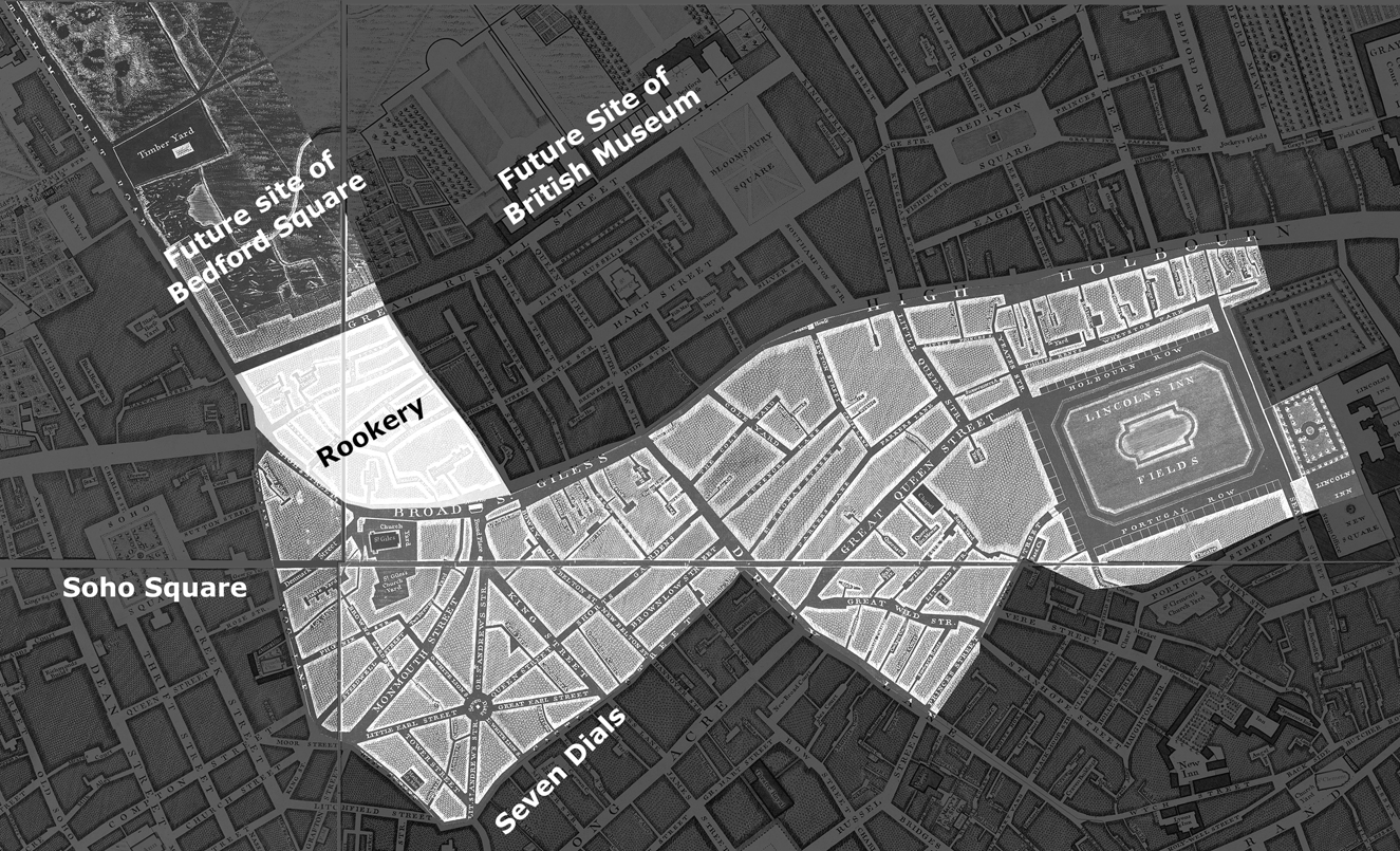
The containment of the Rookery is important, because though the whole parish of St Giles-in-the-Fields became synonymous with depravity, most of it was desirable in the eighteenth and early nineteenth centuries. On all four sides, the Rookery looked into wealthy communities. To the immediate west was the charming and famously French area known as Soho Square, just across the parish boundary.Footnote 29 To the south was ‘Seven Dials’, whose owner converted a marshland into a new commercial district between 1693 and 1708. The seven intersecting streets – dials – met at a Doric pillar and were designed to leave a recognizable mark on the map. The area was built with the intention of charging higher than average rents for properties facing wide streets that would attract shopkeepers.Footnote 30 Though it would fall into decline by the 1850s, when it was first built, Seven Dials was in a middling commercial space. To the east was the parish of St George Bloomsbury, home to the palatial mansions Montagu House and Bedford House – the former purchased as the British Museum in 1759. And to the immediate north, from the 1780s, was the Bedford Estate, a well-planned multi-street development aimed at a genteel audience.Footnote 31 By 1763, the duke of Bedford owned the land both to the north and east of the site, having purchased the latter to extend the footprint of his sprawling Bloomsbury Estate.Footnote 32 Slightly further away, but still within St Giles (and included within its tax base), was the lavish housing of Great Queen Street and Lincoln's Inn Fields. The owners of houses on these streets stood out locally and paid handsomely when the government came knocking in 1693/94 for a one-off tax on property.Footnote 33 Many of these streets remained wealthy two centuries later when Charles Booth conducted his great poverty map, showing that the Rookery's poverty did not push away the wealthy neighbours.Footnote 34
Migration routes and geographic determinism
The question is why did the Rookery develop as a uniquely poor space in an otherwise nice area? The answer includes the problems of local government already addressed by the historiography, including an over-generous and under-rigorous poor relief system open to abuse.Footnote 35 However, geography too played an important role defining the local land use pattern, as it often did in the development of run-down districts. As Dyos noted, the presence of a nearby migration end point, such as a railway terminus, a bus station or a port, was one of many risk factors that made a residential site more susceptible to decline.Footnote 36 That risk factor certainly was at play in St Katherine's, a dockside parish in London's east end, which showed clear slum-like conditions in the nineteenth century, and had a large number of (often temporary) inhabitants engaged in sailing and the trades that supported it.Footnote 37 Those forces of migration did not damn St Katherine's to slumdom, but they did increase the risk by providing the endless supply of bodies arriving on the thousands of ships fuelling London's economy. St Giles was not dockside. However, despite being far from the river, the location of the Rookery within London and Britain was one of its key risk factors for decline.
The Rookery site stood for decades on the city's outermost frontier – the edge of the edge of town. For most of its history, St Giles was a field about a mile distant from both the walled City of London and the seat of national power in Westminster. In the medieval era, St Giles was home to a leper hospital considered a safe distance from both.Footnote 38 Over the centuries, the hospital fell into disuse and disappeared, and by the late Elizabethan era, London had begun to expand outwards.Footnote 39 A few landowners in possession of the surrounding farmland slowly carved up their parcels of land to house the growing number of arriving new Londoners.Footnote 40 In the north-west corner of St Giles-in-the-Fields was the five-acre site that would become the Rookery. Its first modern buildings went up in the late sixteenth century – a row of smart dwellings lining the High Street.Footnote 41 Behind them lay pasture that stayed untouched for nearly a century (see Table 1).
Select cartographic history of the site, showing the growth of roads and buildings, 1560 – c. 1725. The maps contain many errors and were often copied from earlier maps rather than surveyed directly from the land.

Soon after those houses were erected, the city abruptly stopped expanding. A decision by the state restricting building to prevent the spread of the plague was followed closely by the arrival of the Civil War.Footnote 42 As the threat of Royalist forces grew, the city's parliamentary leaders decided to dig in and fortify, freezing London for a generation. Up went an earthen work wall around London and its environs, supported by a network of forts. The wall and one of its forts were positioned directly across the street from the Rookery.Footnote 43
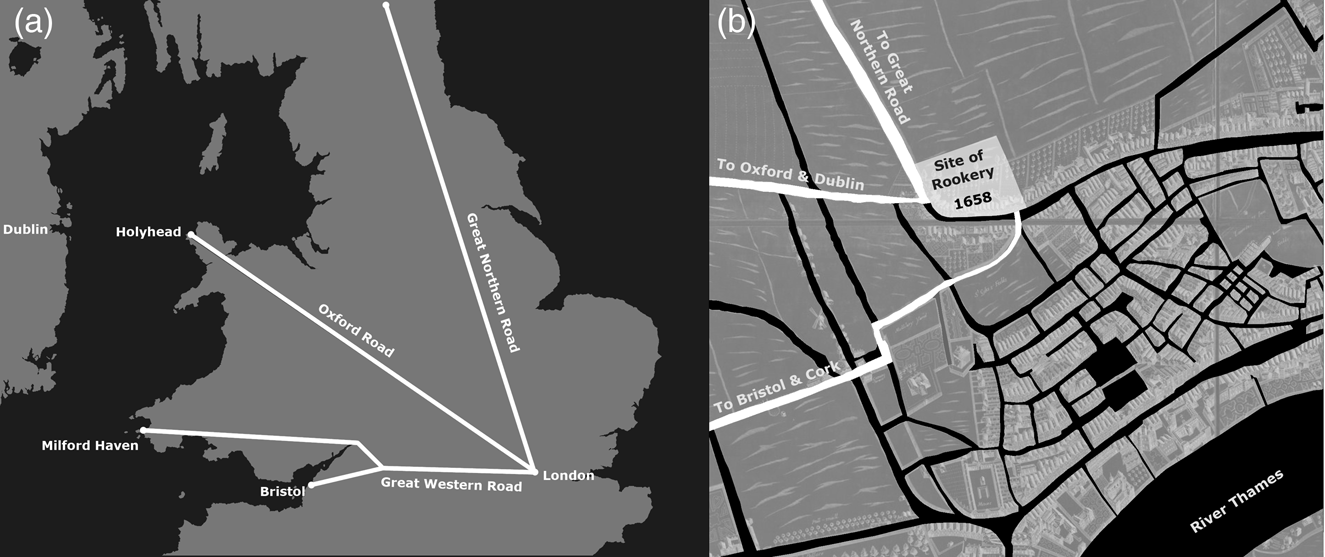
The fact that this happened when the Rookery was on the edge of town was a matter of chance. Because the urban sprawl stayed still for so long, the site became the symbolic edge of the metropolis, even decades after building resumed further afield in the 1690s.Footnote 44 To mark that symbolism, and to replace a badly decayed church in the parish, in 1715 the local authorities submitted a proposal to the government seeking funding for a new church directly across the street from that infamous slum in the making.Footnote 45 The parishioners argued that it would be a great monument to London, the first spire travellers would see on their way into town. A century later, Rowland Dobie wrote that ‘a good church there, would be as great an ornament and as much exposed to view as any church which could be built in town’.Footnote 46 The locals were not exaggerating when they talked about their church as the first spire travellers would see. For a huge number of people, it was. That was because the national road network put the Rookery at the end of three of the most important routes into London: one of the branches of the Great Northern Road (via Hampstead), and both major routes coming from the west (via Oxford and via Bristol).
The Great Northern Road was the chief pathway into London from the north, servicing all of the growing towns and cities of Yorkshire and onward to Scotland's furthest reaches. It split a few miles north of London, with the ‘Hampstead Road’, becoming Tottenham Court Road as it entered town. Tottenham Court Road ran along the Rookery's edge, making it a single road to St Giles for people from across large sections of Britain. Travellers from the west arrived via the Great Western Road, connecting London to Bristol (and all counties beyond and along). This included migrants coming from southern Wales, as well as travellers from the southern parts of Ireland who made landfall either at Milford Haven in Wales or Bristol.Footnote 47 In the seventeenth century, this road entered the London area just south of Hyde Park, becoming Piccadilly Street. There, travellers could either turn south towards the Strand or jog north slightly, again ending at the Rookery, where they finally encountered the first clear signs of an urban landscape.Footnote 48 Given the apparent high numbers of migrants from Cork living in the Rookery in later decades, many of them must have made that turn northwards.Footnote 49 For visitors arriving from the English Midlands, industrial fledgling hubs of Manchester or Liverpool, the north of Wales or Dublin and the Irish north, the road of choice was the Oxford Road, connecting Holyhead in Wales (the shortest crossing to Ireland) to the city of Oxford, before arriving in London as Oxford Street. Prior to its extension in 1847, Oxford Street ended exactly at the Rookery. One simply could not miss it.
These three roads serviced the vast majority of British and Irish travellers to London. Only migrants from the east of England or counties south of the Thames (Hampshire, Sussex, Kent and Surrey) would arrive on other roads. Only the River Thames could compete in terms of traffic and at least until the nineteenth century most people preferred the safety of an overland journey. This included the Irish who walked from Wales rather than sailing all the way to London. The Irish Sea was a dangerous body of water, and even lord lieutenants of Ireland were recorded catching a short boat trip via Holyhead following a long coach journey.Footnote 50
The connectedness to Ireland may help to explain the Irish presence in the St Giles area, and their continued arrival in the area many decades after it was no longer the edge of town. Their fellow Irish men and women encouraged thousands of migrants arriving along the road to go to St Giles as part of a well-worn path between Ireland and London. While en route in 1811, Catharine Hannagan was advised by a stranger that ‘if I was to go to St. Giles's I might find some of my country people who would give me a lodging’.Footnote 51 St Giles was also a key node for coach passengers seeking to travel between London and Ireland, with coaches leaving the George & Blue Boar inn daily at 9am and 3pm to the Emerald Isle. All three of the other coach departure points from London in 1814 left from inns within a mile of the Rookery.Footnote 52
This connectedness to Britain and Ireland was uniquely strong for the Rookery. Of the 19 roads into London in the 1650s, including the River Thames in both directions, the Rookery was the first urban point in London for the three most substantial of them. Only one other site could claim two (the crossroads of Great Dover Street and Blackman Street in the Borough in south London), and they serviced far less of the country. Between them, the Great Northern Road, Oxford Road and Great Western Road were the logical migration routes into London for colossal numbers of people (Figure 4(a) and (b)). Dobie was justified when he described the area as ‘the great thoroughfare’.Footnote 53 Its placement on the road network therefore subjected the Rookery to a unique degree of geographical determinism as a space associated with the forces of migration.Footnote 54 It did not seal the fate of the space, but it did make it unusually well connected within London, just as riverside parishes such as St Katherine's were sculpted by their proximity to key migration routes.
(a) Map showing the rough path of the Great Northern, Oxford and Great Western Roads into London. (b) Annotated detail of William Faithorne's An Exact Delineation of the Cities of London and Westminster and the Suburbs Thereof, Together Wth. Ye Burrough of Southwark (London, 1658), about a century before it became the ‘Rookery’ slum.
Land ownership and economic opportunism
Even though London's footprint grew between 1675 and 1799, John Landers calculated that a greater proportion of Londoners than ever before were dying in St Giles, rising from 7 to 11 per cent of London deaths. As a proxy for population growth, that suggests St Giles was growing proportionately faster than London in the eighteenth century.Footnote 55 Thanks to the area's connectedness to migration routes, its owners had economic opportunities for the short-term accommodation business that may not have been as viable in other parts of the city. Over a number of generations, those owners made decisions that took advantage of that opportunity, with gradual but tragic consequences for the area. Not only did this lead to overcrowding, but so many short-term residents could inhibit the development of a community who would claim civic ownership over the space.Footnote 56 By the nineteenth century, the site certainly had became associated with transience. David Green and Alan Parton's analysis of settlement examinations in the 1840s showed that nearly a third of Irish inhabitants had been staying in the Rookery less than a year.Footnote 57 Meanwhile, Joseph Oppenheimer remarked in 1862 that half of the population changed each month.Footnote 58
The cause of this nineteenth-century transience was in part due to the approach towards building a century earlier. Like many parts of London, the Rookery was developed at the level of the multi-street estate. A landowner in early modern London was able to create a neighbourhood befitting his own tastes and budget – outlined in great detail in the Survey of London series and in Olsen's survey of Bloomsbury.Footnote 59 The effect of the creativity of these men could be seen on the map even centuries after the minor roads were laid out and the buildings constructed. Many of the original plots can be guessed at on the map today, sitting between the wider boulevards of the transportation network.
This system of building meant that the new western suburbs of London developed into a patchwork of neighbourhoods lacking a feel of town planning.Footnote 60 It meant the owners of the marshland in the south-west of St Giles could build the visually creative Seven Dials commercial hub, while the duke of Bedford could stamp a residential trophy on his own plot.Footnote 61 This type of trophy building was much easier to achieve in London's newest neighbourhoods than in its more ancient and already-built areas closer to the River Thames. Few people would describe the Rookery as a trophy, but despite what became of the space, its owner too had a plan that he felt best suited the site.
Despite their power, urban landowners are too rarely part of the social histories of poverty and migration. Nevertheless, the motives and actions of owners are a crucial part of the story. This was particularly true in the Rookery, whose land was at least originally the estate of a single family. James Blount, Lord Mountjoy (whose son would serve as lord lieutenant of Ireland, in one of many Irish connections of the owners over time), may have been responsible for the first houses on the property in the mid-sixteenth century. Blount sold the property and by 1649 it had reached the hands of Henry Bainbridge.Footnote 62
Once the Civil War defences came down and the monarchy was restored in 1660, the Bainbridge family had a chance to enact a hands-off agenda. They began laying a network of streets, naming one after themselves and others after their three sons-in-law (Maynard, Buckridge and Dyott). Then, before taking his final breath, William Bainbridge carved up the estate into a series of three plots that were leased to individual developers.Footnote 63 This meant that the building work fell to the developers who had acquired their plots with commercial ambitions. The daughters who inherited the sites would not have to (or be able to) make further decisions about the properties while the long leases remained in term. Bainbridge was motivated by a perhaps chauvinistic if paternal approach to passive land management and inheritance that would ensure his three daughters had a steady stream of income after his death: a father's gift to his girls.Footnote 64
As Linda Clarke has shown, before the nineteenth century, the most common approach to urban development was for the landowner to lease land to a developer who would improve it by building. That developer owed ground rent to the landowner, and then recouped the cost by selling the lease or letting to someone else who could occupy the site. Further leasing and subleasing continued until someone may have been paying to occupy a corner of a room by the night.Footnote 65 This was the system of development used on the Rookery. It was not inherently a problem nor was it necessarily a cause of slumdom. Many neighbourhoods in London were developed using the same system, without suffering the same fate as the Rookery. The duke of Bedford used this approach to develop his nearby estate, as did the board of the Foundling Hospital in developing its lands, and though some parts of both fell into disrepair, neither ever faced problems on the scale of the Rookery.Footnote 66 The original developments within the Rookery consisted of substantial houses, with a couple of public houses and commercial ventures along the High Street and were no higher risk than other streets in the parish.Footnote 67 However, in time, the high foot traffic in the area, and the fact that the relatively large buildings could easily be converted into smaller apartments, saw a number of these houses begin to operate as lodging house businesses that offered short-term accommodation, food and drink for paying guests. This form of enterprise soon dominated the estate, and the word ‘lodging’ outside of buildings is a regular visual trope in drawings of the area.Footnote 68
Once built and operating as a lodging house, nobody had or needed a grand vision. While many landlords ensured their leases prohibited a wide range of commercial activities that could be considered undesirable for quiet living, this was apparently not the case in the Rookery.Footnote 69 The presence of long leases with few conditions regarding upkeep requirements limited opportunities to overhaul the area. The lax nature of the requirements may have resulted from bad planning by the owners who perhaps received poor legal advice on drafting their leases, or may reflect the fact that, unlike some other substantial landowners in London, they were fairly small-time developers with comparatively limited experience in developing urban spaces. While it may not have been a cause of decline, this system of building and leasing was a barrier to rejuvenation.Footnote 70 The only people with any impetus to sculpt the Rookery were the lodging house operators – a group of small business owners operating in rented premises. According to a schedule of rents due to the Rookery landowner in 1815, the keepers of the houses owed from £20 to £100 per building per annum, depending on size and location.Footnote 71 With that in mind, run efficiently, a lodging house may have expected an annual income in the region of £150–300.Footnote 72 That figure was before extra charges were added for food and drink. In some cases, this could also include the landlady's share ‘when a prostitute has decoyed a man’, which was apparently worth ‘half the pay and plunder’.Footnote 73 Thus, a lodging house represented a good small business opportunity in an otherwise undesirable area. The lodging house industry was a significant if often forgotten part of the early industrial London economy. Its major players offered between 500 and 600 beds per night by the early Victorian era, with the city's most prominent entrepreneur worth a staggering £100,000.Footnote 74
In time, fewer people controlled more of the lodging houses. In 1693, unique individuals ran most houses in the area.Footnote 75 By the 1780s, a local businessman let 35 ‘twopenny’ beds.Footnote 76 A generation later in 1815, only 15 people were still listed on the rent schedules. The most prominent was John Hughes, who ran 40 properties, including most of Church Lane.Footnote 77 In the 1840s, that consolidation continued, with only a dozen men on the rent list, chief amongst them a solicitor named Charles Innis who controlled 60 properties.Footnote 78 These were assets, not homes, and increasingly were being run by people who specialized in the trade and controlled larger and larger holdings in what was already a run-down area. It was the John Hughes’ and Charles Innis’ consolidating long leases, amassing large property portfolios, and running impoverished lodging houses, who were closest to the causes of the gradual decline.
But the lodging houses were serving the needs of the local market, which needed an inexpensive place to sleep.Footnote 79 The inhabitants came from a range of backgrounds and daily paid occupations including the servants who supported the privileged lives of the rich in the surrounding neighbourhoods, those who built the tens of thousands of new houses and laid the hundreds of miles of roads London would need as it pushed further outwards and the boisterous hawkers and street sellers that sustained London's vibrant streetlife throughout the period. An observer in 1850 remarked on both the crowding of rooms, but also on the need to share space with ‘large quantities of vegetables, fruit, or shell fish, according to the season’, showing that hawkers lived and slept with their wares within these crowded spaces.Footnote 80 Records of the Old Bailey court show that the area was also home to a number of black individuals, showing that diversity therein extended beyond Irishness.Footnote 81 Building work was especially important to the area. A number of bricklayers held insurance certificates in the Rookery, and a timber yard moved on site after the 1780s.Footnote 82 Archaeological evidence also included materials associated with tin-glazing, smithing and brickwork.Footnote 83 In order to serve this market, the landlords opted for low-end accommodation that was cheap enough for someone at the end of a long journey with little left in his or her pocket, and located conveniently for the city's many precariously employed builders on the edges of an expanding city.
The conditions of these sites probably degraded steadily over time, the result of so many hands and feet leaving cumulative impressions as they passed through the area. There is little evidence of any voluntary investment by the lodging house operators, who opted instead to squeeze pennies from their time-limited leases. By 1787, a writer claiming to be a lodging house keeper in St Giles gave a rare description of his premises, using language that he probably thought made it sound better than it was:
there is no more than one bed in each room, there are usually two or three, and sometimes even four occupiers of that one room and bed. That the furniture is of an expensive and luxurious kind, no one can say; as it consists only of a stump bedstead, a flock bed, a pair of sheets, (frequently only one sheet) a blanket or two, a chair or two, (generally without backs) and a grate, but mostly without shovel, tongs, and poker.Footnote 84
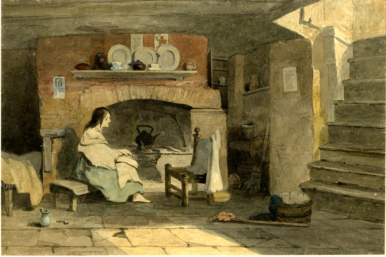
According to John Styles’ analysis of urban pauper lodging, the above description was well below the norm in terms of provisioning of a room, lacking at least a table and basic implements to use for washing and eating, as well as other comforts such as rugs, cooking implements, mirrors and even artwork for the walls.Footnote 85 This made the provisioning in St Giles a stand-out, even at the bottom of the market, and suggests the presence of a landlord's market rather than one dictated by the tastes or wants of the occupants. The reality may have been slightly better than described. One of the Wykeham Archer paintings from 1844 shows a woman (possibly imagined) in a St Giles cellar with a much broader arrangement of effects than one might imagine from the descriptions of want: a washbasin, broom, kettle, teapot, a range of implements for eating and storing foodstuffs, and even some rudimentary artwork on the wall (Figure 5). If the room in the painting was real, it is likely that some of the items belonged to the woman, while the landlord supplied others.
John Wykeham Archer, ‘A Cellar in the Rookery, St Giles’ (London, 1844), British Museum, 1874,0314.114.
Those with more money could call upon houses further up the road that could offer more respectable conditions.Footnote 86 Within the Rookery, many (if not all) of the lodging houses focused on a high-density, short-term model, hosting guests by the day or week. The stiff competition drove prices down to rock bottom levels, with some charging as little as 1 pence per night for customers willing to sleep on the bare floorboards.Footnote 87 Every effort went into maximizing the volume of customers to make up for the low prices. This included digging down, a common enough practice in London and an opportunity to expand the rentable space into the bowels of the earth, but one that without natural light, ventilation or drainage created breeding grounds for typhus or what was sometimes referred to as ‘Irish fever’.Footnote 88
Building also extended backwards. Traditionally, rear garden space in behind London houses was used for hanging out washing and disposing of liquid waste. However, within the Rookery, these spaces were used for industrial purposes, reinforcing Roy Porter's claim that London still lacked a public health movement in the eighteenth century, despite growing awareness of the need for good clean air.Footnote 89 There were four such sites in the Rookery: a timber yard and three breweries that operated at different times (one brewery per daughter, remembering the split made by Bainbridge).Footnote 90 These industrial premises meant that few houses had anything resembling a back garden, and made sanitation particularly difficult. As a space that was (at the time) on the edge of town, the location for heavy industry was perhaps not as odd as it might now seem. It may also have been a strategy learned by the landowners on their similarly run-down Bermondsey estate south of the Thames, which too blended industrial and residential space, including a nearby brewery, distillery and wool-stapler.Footnote 91 The dust of the timber yard and the smell of the brew houses drove away those seeking a place to live who could afford accommodation in areas that offered fewer assaults on the senses. The industrial sites also proved dangerous; in 1814, an accident at the brewery cost eight inhabitants of the Rookery their lives when thousands of gallons of beer escaped, collapsing a house.Footnote 92
Had there been better planning regulation or stronger leases with clauses to require repairs, the Rookery may not have faced decline, but planning powers remained lacking. Even as late as 1850, the Metropolitan Commission of Sewers repeatedly agreed with complaints about the Rookery's inadequate sanitation, but also noted that the problem ‘cannot at present be reached by any existing legal provision’.Footnote 93 In other words, it was not within their remit to fix the problem. That failure in sanitation had been made worse by decades of growing local density, caused not only by the lodging house business model but also by one of the brew house leases expiring in the second half of the eighteenth century.Footnote 94 Up to that point, all accommodation had been in houses with direct access to a main road. Thereafter, the new leaseholder chose to draw on the success of the accommodation business in the area and saw an opportunity to build dozens of tiny buildings to rent out where the brewery had stood.Footnote 95 The result was a dense tangle of buildings (Figure 6), which was the state of the property in 1851 when it was put up for redevelopment.
Section of the Rookery with buildings, passageways and courtyards, 1851. The darkest grey buildings were formerly the site of the Eagle and Child brew house, which was converted into space for additional housing. London Metropolitan Archives, Dyot Family (1851–52), ACC/1852/006–008.
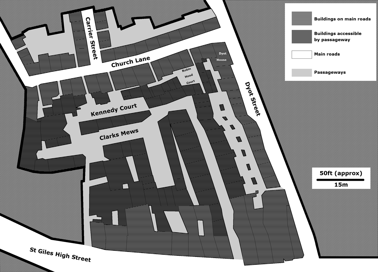
Once the brewery site was converted to housing, most of the buildings in this part of the Rookery could not be seen from the main road, and were accessible only via narrow passages, many of which were two feet wide. It was these passageways leading into a large central area that gave the Rookery a maze-like reputation. With nearly a dozen ways into and out of the site (front doors notwithstanding) a rogue on the run with local knowledge had many options for evading a pursuer.
Ever-more capitally inclined people with time-limited access to the site dictated by the terms of their leases had found ever-more ways to increase the rentable space in the area, and the living conditions of the locals suffered accordingly. The effect was dangerous overcrowding. According to a Victorian-era estimate, some parts were even more densely settled than the spaces below deck on transatlantic slaving vessels, and five times more packed than minimum standards for space in the prisons of the day.Footnote 96 The conditions blurred the lines between rough sleeping and sheltered accommodation. The lack of sanitation facilities, and the fact that nobody really had any private or secure spaces of their own meant that inhabitants knew it was better to drink your wages than have them go missing in the middle of the night. The risks of this were widely known, even amongst the middling sort. Hannah More's moral tale about the Rookery, Betty Brown, The St. Giles's Orange Girl, described the plight of a protagonist who was swindled of her wages each day by someone meaner and more cunning than herself.Footnote 97 The lack of security for tenants was a reality that kept the poor in a state of poverty, and helped keep the slum a slum.
The need to keep beds full also meant that lodging house operators learned not to be selective about their clientele. In a city still full of anti-Catholic sentiment, that made the Rookery's strong Catholic connections very unusual. In part thanks to the strong links between Ireland and this corner of north-western London, the site had earned a range of Irish-inspired nicknames such as ‘Little Dublin’, ‘Little Ireland’ or ‘the Holy Land’, all of which implied Catholic connections for Protestant observers.Footnote 98 This Irish Catholic community was well established by the mid-eighteenth century and can be seen by mapping the street-by-street Catholic presence in the area using the 1767 Returns of Papists. The returns show pockets of intense Catholic occupation, including in the Rookery where 621 Catholics (many if not most of whom were Irish) were found. This was probably a low estimate and may not have included people paying by the night.Footnote 99 The Catholic tenants in the area were more likely to be renting from a Catholic householder than in other parts of the parish (57 per cent of Catholics in the Rookery rented from other Catholics, compared to a parish average roughly half that value). It was these Catholic householders who were operating many of the lodging houses in the area. This suggests that even by the 1760s Irish Catholics had colonized the Rookery and were actively using it as a Catholic rented space where Catholics did business with each other.Footnote 100 Further growth of Catholic local infrastructure included St Patrick's Catholic Church, established a few hundred metres away in 1792, and a Catholic chapel was registered within the Rookery itself in 1802.Footnote 101 A Catholic charity school was established in 1803 across the road to support local Catholic orphans.Footnote 102
Tolerance of Catholic occupation was not universal, making the owners of the Rookery the exception and pointing further to how the site was different from the wider parish. Hints of anti-Catholic rental patterns elsewhere in the parish can be gleaned from the same Returns of Papists, which show that a pair of streets in a nearby slum nicknamed ‘Little Sodom’ had wildly different rates of Catholic occupation. The records identified 202 Catholics on Lewkner's Lane and only 28 on the immediately adjacent and similarly sized St Thomas Street.Footnote 103 With ownership the only key difference between the two streets, individual landlords had a heavy influence over the character of their small pockets of London. David Green's maps of pauperism in St Giles in the 1840s show that there was tremendous continuity 70 years later, with both the Rookery and Lewkner's Lane continuing to stand out, not as Catholic spaces, but as poor ones.Footnote 104 Better understanding those landlords and the pressures they faced is therefore important for understanding how spaces such as the Rookery developed and why adjacent streets fared very differently.
Powerful ghosts
The fact that the Rookery developed on that original single estate of William Bainbridge is too much to overlook when seeking an understanding of the poverty that developed there. As the only people with a long-term vested interest in the land, it was the owners who could have stepped in to put an end to the rampant speculation on the site. But they did not. Why? We cannot know their morals or beliefs but we can trace the money trail across the generations, and when we do that it becomes clear that the family may not have had enough money to improve it. As Olsen has shown, improvement was expensive, with its advantages rarely felt until two or three generations later, giving little impetus to any but the most dynastically inclined.Footnote 105
When William Bainbridge divided the Rookery estate in three for his daughters in the late seventeenth century, he made one of the last free decisions about the property for more than a century.Footnote 106 Until the slum was finally redeveloped in the Victorian era, the site was rarely fully in the control of its owners, making it very difficult for anyone to make sweeping improvements. Over several generations each subsequent owner was bound by conditions, wills, financial troubles and matters outside of his or her control. For most of those years, the landowner had little option but to treat the site as a source of passive income (particularly the case for women). Even those who tried to redevelop it found their hands tied, until ultimately they had to go before parliament in 1815 to free the site from the ghosts of owners past, allowing its then owners to sell the dilapidated site and buy a new one elsewhere, and thereby allow someone with a new vision for the area to take over.Footnote 107
Beginning with Bainbridge, the site became further entangled with each passing generation. Bainbridge's son-in-law Symon Dyot inherited the ‘Dyot’ third of the estate in the late seventeenth century. His wife Jane and son Richard took control after his death, using the property to land Richard a good wife. First Elizabeth Evelyn, and then after her early death, the daughter of a diplomat, Arabella Meadows, became Richard's brides. The families of both women insisted that the estate be put under the control of a board of trustees who would ensure that it remained intact for future children, effectively removing it from Richard's control. From 1692 when he married Elizabeth Evelyn until 1741 when Arabella died, that board was in charge of the land upon which the Rookery stood, paying only enough attention to ensure Elizabeth and then Arabella received its dividends.Footnote 108
After Arabella's death, the estate passed to her son Philip, a magistrate, who held the property until his own death in 1792.Footnote 109 Unfortunately, Philip's tenure was immediately hindered by a lawsuit brought by his half-sister Jane who had been promised an unpaid £3,000 inheritance from their father. Richard had probably been unable to pay his daughter when it had been due. In 1710, he was arrested and charged with embezzling as much as £100,000 during his duties as stamp collector, and spent at least a year in prison, begging the queen to let him go into exile.Footnote 110 He may well have stolen the money, shifting it quietly to his wife who (either legitimately or not) acquired a substantial volume of South Seas Company stock that collapsed in the infamous bubble, which washed away much London wealth. Arabella had opted not to or was unable to pay her step-daughter the £3,000 owing when she inherited the estate after her husband's death.
With no satisfaction forthcoming, Jane sued her half-brother as soon as he came into the inheritance. Philip settled out of court and had to take out a large mortgage against the Rookery land to make the payment. Already run-down after decades of passive management, Philip now found himself the owner of a seriously indebted property.Footnote 111 To pay it back, he turned to a career in the law, sitting as a local magistrate from ‘Dyot House’ on the Rookery's eastern edge, living amongst the people he judged and contributing to the large legal paper trail we now use to understand the true nature of the neighbourhood.Footnote 112 From his living room in that house, he spent his days chipping away at the mortgage, filling one pocket with ground rents, and the other with fees for judging his neighbours.Footnote 113 Philip had a unique level of power over who those neighbours would be. If the site became too crowded or troublesome, he had the power to expel outsiders for a profit using the laws of settlement and the vagrancy act to his financial advantage.Footnote 114 Upon his command, any outsider brought before him could be expelled from London, sent back to their parish of legal settlement while Dyot collected a small fee for each. He was one of the city's most prominent users of the vagrancy system, sending away three times as many people as the average magistrate of his day – a quarter of whom were sent back to Ireland.Footnote 115 He earned if they stayed, and he earned if they went.
Despite his local power, he was by no means a big player in the landlord game. His entire estate would have fitted comfortably a dozen times over into the duke of Bedford's adjacent property – one of three of similar size that the duke held. The scale of Bedford's operation meant that he had more robust leases that let him take back properties left to rot, had the capital to do so and kept a surveyor on the books who paid at least occasional attention to any breaches.Footnote 116 Dyot could afford nothing comparable for his small operation. He also had very little control over who leased his properties. The decades long leases (often signed by an earlier generation) were bought and sold openly. If Philip wanted control, he had to buy the leases one at a time, and only if he could find a willing seller. The economic approach he took towards the site may not have been his first choice, but the debt he faced meant that he was unable to buy back the leases. Given his profession and resigned to his debt, Dyot may have had a vested interest in the area's continued poverty, as it provided him with an endless supply of judicial business, just as the road network supplied the lodging house keepers with endless tenants.
Over the course of the next two generations, the estate continued to be managed passively, while active management of individual houses rested with the investors who held their leases. It passed from Philip to his great nephew, an absentee landlord and MP, who saw the Rookery as a source of income until his death in 1808.Footnote 117 The nephew passed it to his own daughter (also Arabella), but as was done a century before, arms-length executors were appointed to run the business. They were given instructions to ensure his daughter received ‘pin money’ from the rents in perpetuity, but would not have a right to active management.Footnote 118
Having now sat for more than a century without owners able or willing to engage actively with the area, the Rookery had fallen into deep disrepair. Unhappy with the status quo and wanting out, Arabella and her husband fought for the better part of a decade to take control of the derelict site, finally succeeding in an 1815 act of parliament that allowed them to sell the property, which was at that point bringing in £1,366 in rent per annum (only £300 of which was earmarked for Arabella under the terms of the will and the rest vanishing into the pockets of the trustees or going out on expenses).Footnote 119 These challenges to the finances and management of the estate were certainly contributing factors in the decay of the buildings and gave time for more financially solvent men such as Charles Innis to consolidate a little empire on the site that he could let out by the room.
After having been carved up into a series of small leasehold properties in the late seventeenth century, the land was put into a trust from 1701 to 1741, was in serious debt from 1741 to 1779, under absentee management from 1792 to 1808 and run by uninterested trustees from 1808 to 1815. Not until the mid-nineteenth century would attempts be made to revitalize the site, led by the intentional driving of New Oxford Street through the slum in 1847, mirroring the approach its planner James Pennethorne had used to knock down Westminster's notorious ‘Devil's Acre’ a few years earlier. It would take another generation to really lift the area out of the poverty that had plagued it for so long.
Even when the area became a social problem for the authorities, there was not much anyone could do to deal with the root of the problem. Instead, only the symptoms could be addressed: fines could be issued and offenders arrested – sometimes repeatedly. An Englishman's house is his castle, as the adage goes, and as long as the owners and business operators followed the laws set by parliament (including the building codes established by the Rebuilding Acts after the Great Fire and a pair of acts in the 1770s), they were free to operate despite the anti-social effects the lodging houses were having on the area.Footnote 120 This was a society that still lacked a public prosecutor (though building code violations could be and were targeted by district surveyors), and it was beyond the ability of the site's poor inhabitants to take the legal steps necessary to hold owners to account for sub-standard living conditions.
Even if someone did want to complain, the family who owned the site was deeply embedded in local politics and emboldened by deep legal knowledge. Their numbers included members of the powerful Select Vestry that ran local government in the parish, and a local magistrate.Footnote 121 Philip, like his father before him, was especially active in London politics in the middle decades of the eighteenth century. In St Giles, he sat as a magistrate. In Middlesex more broadly, he was a regular at Hicks Hall where he participated in the Middlesex Sessions of the Peace, making decisions about a wide range of metropolitan matters.Footnote 122 He also took up a seat as one of the (many) governors of the Bridewell Royal Hospital, where he was part of the establishment making recommendations on what to do with the poor.Footnote 123 This was a family not afraid to defend their turf, appearing repeatedly in the Court of Chancery fighting cases related to the property.Footnote 124
Powerless to bring change, local people adapted to the circumstances, finding ways to profit from the slum. Not only were those with rights over the land (the landlord, developers and lodging house keepers) making money, so too was just about everyone else. Local businesses benefited from a rich supply of day labourers who were crucial to the construction industry and to wealthy Londoners seeking live-out servants. Others were more entrepreneurial in their approach, including the vicar of St Giles, Henry Gally, who saw the large numbers of Catholic people in the parish as a potential source of income for his church. His Some Considerations upon Clandestine Marriages is a thinly veiled advertisement for his marriage services for the Irish Catholics in the parish who wanted to legitimize their vows in a Protestant church.Footnote 125 Two generations later, some unscrupulous local officials too learned that by taking a lax approach towards poor relief record keeping, they could line their own pockets with the leftovers from the poor relief chest, outlined in detail in Rowland Dobie's 1829 tell-all book. If they can't be fixed, slums can pay, it would seem.
Conclusion
From an under-mapped space allegedly too dangerous to enter, to the offices of the search engine company which has done more than anyone else to map our modern world, there has been a striking shift in the use of urban space on the land once occupied by the Rookery. This case-study has been an important opportunity to understand a historical slum through its long decline. What this article has shown is a need to add to the way we understand slum development.
In his monograph-length 1829 exposé, Rowland Dobie highlighted gross mismanagement of poor relief funds as a key local problem. This fraudulent behaviour certainly took place, but it was not on its own the cause of the area's decline, despite claims to that effect a century later by Dorothy George.Footnote 126 In fact, a study of the local government alone is insufficient to understand the many factors that pulled upon this space over the decades.
First, the Rookery of St Giles was one of a number of key international migration end points in London. Its location at the edge of town provided an endless stream of people arriving on foot. That made it an ideal location for those with experience in the short-term accommodation business, with an emphasis on the low end of the market. Secondly, this was a site that was sculpted by the family that owned it and the drama of their lives as well as the relative modesty of their landed enterprise compared to bigger and better resourced competitors such as the duke of Bedford. Deaths, wills, long leases, betrothals, trust funds, hundred-thousand-pound embezzlements, royal pardons, stock market crashes and lawsuits between step-siblings left the property so entangled that it would take an act of parliament to release it for redevelopment. It is easy to forget the owners and the role they played over the development and decline of their properties. This article brings the Dyot family in particular back to the forefront of the story to foreground the economic approaches that they took towards their properties, and the effects that those decisions had on the local area.
Finally, this article has addressed the structural reasons for the pattern of land use that underpinned the birth of a slum. The Rookery as a case-study shows how an urban space was subject to the forces of macro geographies of migration, but also the economics of development in the early modern period, and the micro forces of multi-generational marriage contracts and wills within a landowning family. These factors complement existing known problems such as the issues of haphazard local government already well understood. Only by putting them all together and considering the long durée does the full picture emerge of the birth of an urban slum.



