1. INTRODUCTION
Table 13-2 in the Admiralty Manual of Navigation Volume 9 (Royal Navy, 2008a) describes the accuracy (95%) of astro navigation as ±2 nautical miles (nm) and yet the Smithsonian Museum describes how the NAS-14V2 Astroinertial Navigation System provided the SR71 with course guidance to an accuracy of 90 metres. Why are these two figures different?
Whereas the Table in the Admiralty Manual of Navigation Volume 9 (Royal Navy, 2008a) treats all astro navigation errors as random in nature, this paper will show by analysing a series of practical astro problems that many astro errors are in fact systematic. This paper will illustrate how previous generations of navigators used knowledge of these errors to achieve greater accuracy than those who consider those errors as random.
Many previous articles from the Journal of Navigation, United States Institute of Navigation Journal and in other open sources indicate levels of accuracy better than ±2 nm. This paper seeks to look at the underlying principles of astro navigation and answer why NAS-14V2 can assume such a high levels of accuracy. This accuracy will be considered following the process recommended by Lecky (Reference Lecky1918a), who counselled in “Wrinkles of Practical Navigation”:
“To place faith in rules learnt, Poll-parrot fashion, and to navigate a ship thereby, is indeed to tempt Providence. It is a miserable and discreditable system which permits it”.
“In each problem which engages his attention, the navigator, to be a navigator, should have the principle at his finger-ends; so that relying upon accuracy of his reasoning rather than on the distinctness of his recollection, he may be able to solve it whenever called upon.”
To show these principles, a voyage was undertaken from Southampton to Ascension Island on the MV Anvil Point in July 2012. While this could only amount to a small sample of astro navigation conditions, it did cover a voyage from 51° N to 7° S. On this eleven-day voyage the following sights were taken every day:
• a meridian sight of the Sun;
• a morning or afternoon sight or both; and
• a position calculated from a series of simultaneous sights in the morning or evening or both.
The accuracy of these three main types of sight will be considered, together with the Sun-run-Sun process, and the underlying principles that affect their accuracy.
2. A SIMPLE METHOD OF FINDING LATITUDE – THE “MERIDIAN SIGHT” (NOON)
2.1. Method
This is perhaps the most ancient form of astro navigation, and has been understood since before Eratosthenes in the third century BC. This method leads directly to astronomical latitude. It is based on a measurement of the Sun's altitude at the time of the Sun's Upper Transit of the meridian. For a stationary observer this will approximate to the Sun's maximum altitude or “high noon”. If the Sun's declination is changing quickly, as it is at the equinoxes, it may occur fractionally before or after “high noon” or if the ship has a large northerly or southerly component in her course meridian passage will not occur at high noon. The time of Meridian Passage in Universal Time (UT) will equal the time when Greenwich Hour Angle will equal the ship's Longitude measured in a westerly direction.
UT approximates to the mean solar time on the Greenwich Meridian. Solar time can also be calculated from the actual time that the Sun crosses a meridian: this is 12:00 Local Apparent Time. The difference between Mean Time and Apparent Time is the Equation of Time–see Bowditch (Reference Bowditch1984a). The Equation of Time for the difference between Greenwich Mean Time and Greenwich Apparent Time is listed in the Nautical Almanac for 00:00UT and 12:00UT on every day.
EXAMPLE 1. CALCULATING LATITUDE USING MAXIMUM ALTITUDE 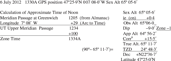
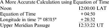
A variety of methods can be used to calculate the exact time of noon (Bowditch, Reference Bowditch1984b). In the late nineteenth century when Lecky was navigating and into living memory, resetting ship clocks at noon was the method used and this enables the calculation below to be conducted.
 $$\eqalign{{\rm Time}\,{\rm of}\,{\rm Mer}\,{\rm Pass}\,{\rm UT} = &1200 \pm {\rm Longitude}\,{\rm in}\,{\rm Time} \cr & \pm{\rm Equation}\,{\rm of}\,{\rm Time}}$$
2.2. Underlying principles and practical reasoning
2.2.1. Time
We now have two times of noon – 12:34UT approximate or 12:33:22UT accurate obtained by the calculations above. If noon is taken at 12:34UT it will give a different answer to taking noon at 12:33:22UT. Most navigators will dismiss this error as insignificant and easily resolved by taking the Maximum Altitude. However the Maximum Altitude may not equate to Meridian Passage (Royal Navy, 1954a). If the ship was stationary the Altitude at 12:33:22UT would be 0·1′ of an arc greater than that at 12:34UT.
Lecky (Reference Lecky1918b) describes two methods to resolve this issue when on a ship with a major North or South component:
“1. Set clock to Apparent time at the ship for the noon position … . …. and make eight bells by it. Then whatever the altitude maybe at that moment, accept it as the meridian altitude, even though the Sun be still on the rise. Work out the Latitude as usual.
2. Continue observing till the Sun has ceased to rise. Then note time from chronometer and work out the maximum altitude as an Ex-meridianFootnote 1”.
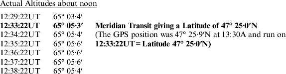
At the time of noon, Anvil Point was on a Course of 208°T speed 17·0 knots ie making 14 knots south and the Sun's declination was decreasing at ·3′ an hour. The result is that the Sun was rising as a result of ship's motion and setting as a result of decreasing declination, making a combined effect of a 15·7′ increase an hour which is laid across the normal sine curve of the Sun's rise and set.
What has been described is just one of the “Wrinkles” that led Lecky to be something of a legend among British practical Navigators in the second half of the nineteenth century.
2.2.2. Errors associated with time
To understand why this level of accuracy (less than half a mile) is easily achieved and why before the advent of GPS the largest positional errors in charts were in terms of longitude, it is necessary to step back from the Sumner Position Line revolution of 1837 described in Bowditch (Reference Bowditch1984c). Before this date and well into the time of Lecky, astro was considered as a two-step process: first find latitude, then find longitude. The position line was a radical new approach heralded by Sumner and perfected by Marq st Hilaire (“1875 Nouvelle Navigation Astronomique”) as cited by Cotter (Reference Cotter1968a).
Although even extremely knowledgeable navigators such as Cotter (Reference Cotter1968b) felt that after the “New Navigation”:
“the problem of finding latitude at sea by astronomical navigation became merely a special case of the general method of obtaining an astronomical position line”.
This is to miss the advantages of sights with azimuths of north or south. Maximum Altitude will only coincide with Meridian Passage on a stationary ship taking an object with a constant declination (eg a star). It can be seen when looking at the altitudes of the Sun about noon on the 6 July 2012 that the Sun's rise slows to almost a stop before Maximum Altitude. Close to noon it appears as if the Sun is stationary in the sky. There are therefore two important benefits to altitudes around the time of Meridian Passage:
• It is the rare moment when navigators can compare their readings and thus beginners can be taught what they should be able to see.
• When a navigational body is north or south it gives even the experienced navigator the time to ensure that his readings are correct.
On a fast moving ship calculating latitude from Maximum Altitude is an error in principle. However if any object is taken with an azimuth close to north or south it will be largely unaffected by time errors. Admiralty Manual of Navigation Vol III page 181 Formula 13 (Re-arranged) states (Royal Navy, 1954b):
 $$\eqalign{ {\rm "error}\,{\rm in}\,{\rm intercept}\! \cr ({\rm due}\,{\rm to}\,{\rm time} \, {\rm error})\!\! } \eqalign {&= ({\rm error}\,{\rm in}\,{\rm HA}){\rm Sin}\,{\rm Azimuth}\,{\rm Cos}\,{\rm Latitude}. \cr &\ \ \ \ ({\rm due}\,{\rm to}\,{\rm time}\,{\rm error} )"} $$
Lecky (Reference Lecky1918b) states:
“if Longitude is known, a very accurate Latitude can be calculated by Meridian Passage provided the Altitude is taken at the exact time of Meridian Passage”.
2.3. Other errors
2.3.1. Horizon
Fundamental to the use of a marine sextant is the ability to see the horizon. If the visible horizon is clearly defined, and the dip is correctly applied, the sextant altitude can be corrected to a measurement about the true horizontal. To achieve this, the visibility must be such that the horizon is clearly defined. For a vessel such as Anvil Point with a height of eye of 26 m this is a visibility of at least 10·7 miles. With a horizon of this distance, the change of height of eye due to movement will be negligible. For smaller vessels even if sharp horizons may be seen in lesser visibilities, motion will become a significant problem. This is particularly true with yachts. On the 6 July the Sun was in the optimum position relative to the horizon with an altitude of 65° and a clear dark horizon was visible, making observations easy.
2.3.2. Dip
The dip tables use the formula Dip in minutes=1·76√height of eye in metres. These are drawn for refraction in normal conditions ie 1010 mb and 10 °C. According to Royal Navy (1954c):
“When the difference between the air temperature (ta) true dip and the sea temperature (ts) is taken into account, the formula for dip becomes; Dip in minutes=A √h(in feet)−B(ta−ts)-where A and B are constants, the exact values of which are still subject to investigation. The formula does however, show that the influence of temperature-difference increases as the height of eye decreases and that small heights of eye should be avoided in the ordinary practice of navigation”.
This subject was further investigated in by Hasse (Reference Hasse1964), where the author cautioned about the risks, particularly on small vessels, of taking Dip from tables without making an allowance for temperature difference.
2.3.3. Sun Combined Correction Table
The refraction tables within the Nautical Almanac for Sun's Lower Limb (LL) or Upper Limb (UL) are drawn up for average atmospheric conditions (1010 mb and 10 °C) and are a combined table for Refraction, Average Semi Diameter for March to October and Parallax. If greater accuracy is required, the Individual Correction Tables from Nautical Tables can be used.
EXAMPLE 2. CALCULATING LATITUDE USING MERIDIAN ALTITUDE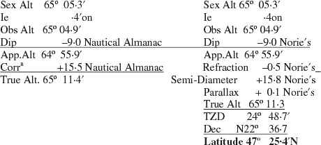
This latitude is the same as the GPS latitude run up to 12:33:22UT. This is probably just good fortune; often greater precision is possible but to a practical navigator it maybe hiding an inaccuracy and is not required, particularly in Ocean Navigation. However an understanding of methods enables them to be applied if or when required.
Lecky (Reference Lecky1918c) draws attention to the risks associated with pretending accuracy, without understanding the basis of that accuracy stating:
“This attempt at exactitude, however praiseworthy in other respects, would often show an ignorance of governing principles which is one of the objects this book (Wrinkles) seeks to remove”.
2.3.4. Astronomical v Geodetic Latitude
Observations of astronomical bodies enables a calculation of Astronomical Latitude. Astronomical Latitude is measured with respect to the Astronomical Zenith although Royal Navy (2011) states:
“Geodetic Zenith. For the purposes of astro navigation, the Observer's Zenith (Z) may be regarded as the “Geodetic Zenith”, which is the point projected onto the Celestial Sphere by a line normal to the Earth's Geodetic Spheroid at the observer's location (ie a point directly above the observer). The Declination of this point (Z) on the Celestial Sphere approximates to the observer's Latitude.”
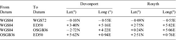
This is in fact a simplification. The practical navigator is actually measuring his latitude with respect to the true vertical at his location. He is measuring with respect to the direction of the gravity field at his location. He does this by using the sea as a form of spirit level and measuring the sensible horizon (true horizontal) from it by reducing the visible horizon by applying dip. The True Vertical and Astronomical Zenith do not equate with the Geodetic Zenith. The amount that these two Zeniths differ varies from point to point on the Earth's surface and is often described as no more than a few seconds. However to a previous generation of cartographers with a regional approach to geodesy the errors associated with this effect were such as to require corrections to GPS positions in the order of a cable. Table 1 indicates some of the differences between different geoid systems.
Datum differences (Royal Navy, 2008b).
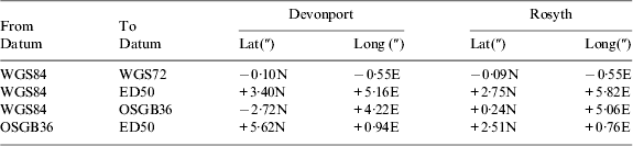
Although to the practical navigator these may not be significant it needs to be remembered when comparing astro positions (measured from True Zenith) and comparing them with GPS Positions (measured from a Geodetic Zenith).
2.3.5. Personal error (Personal equation)
Anyone who shoots will be aware of this error; if a rifle is to be accurate it needs to be set up for the individual using it. When looking through a sight what two marksmen see will be subtly different; the same is true of two observers using a sextant. Bowditch (Reference Bowditch1984d) states:
“Generally, it is possible and desirable to correct any errors being made by the technique of observation, but occasionally a personal error (sometimes called personal equation) will persist.”
To a previous generation of navigators who developed their skill over long periods, this was a significant effect and this effect can only be observed by assessing observations among groups of observers or against an alternative non-astro position.
3. CALCULATING LONGITUDE FROM THE SUN
Latitude can be easily determined even if time is not known by a Meridian Passage of a Star. Longitude has always been a much more complicated calculation. The Earth itself is rotating at approximately one revolution every 23 hr 56 mins measured against the stars, or approximately one revolution every 24 hr 00 mins with respect to the Sun. This means a point on the Equator is moving to the east at 900 knots, and a point at 60° latitude is moving east at 450 knots. It thus follows that the accuracy of a calculation of longitude will vary with latitude and be directly dependent on any time error (see Equation (2)).
To a previous generation of navigators this was critical to their method of calculation and Lecky counsels taking sights either north/south on the Principle Vertical Circle for Latitude or east/west on the Prime Vertical Circle for Longitude (time). The method used was the Time Sight. The basic formula of the Time Sight (using the fundamental formula) is:
 $${\rm Cos}\,{\rm Hour}\,{\rm Angle} = \displaystyle{{{\rm Sin}\,{\rm Altitude} - {\rm Sin}\,{\rm Latitude}\,{\rm Sin}\,{\rm Declination}} \over {{\rm Cos}\,{\rm Latitude}\,{\rm Cos}\,{\rm Declination}}} $$
EXAMPLE 3. TIME SIGHT FOR LONGITUDE
A sight obtained of the Sun's Lower Limb at 08:30:00UT on 6 July 12 Sex Alt 36° 20·7 in GPS position 48 20·9N 6 18·6 W 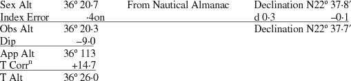
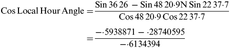 $$ \eqalign{{\rm Cos}\,{\rm Local}\,{\rm Hour}\,{\rm Angle} = & \displaystyle{{{\rm Sin}\,36\,26\, - {\rm Sin}\,48\,20 {\cdot} 9{\rm N}\,{\rm Sin}\,22\,37 {\cdot} 7} \over {{\rm Cos}\,48\,20 {\cdot} 9\,{\rm Cos}\,22\,37 {\cdot} 7{\rm}}} \cr = & \displaystyle{{ - {\cdot} 5938871 - {\cdot} 28740595} \over { - {\cdot} 6134394}}} $$
 $$\eqalign{ & {\rm Cos}\,{\rm Local}\,{\rm Hour}\,{\rm Angle} = {\cdot} 4994802374 \cr & {\rm LHA} = 360 - 60{\rm\deg} \,02 {\cdot} 0 = 299{\rm \deg} \,58 {\cdot} 0'} $$
Once the LHA is calculated it can be applied to the GHA of the Sun to give Longitude
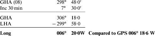
The Time Sight enables the longitude to be calculated without any plotting. Obviously it is at its most accurate when the Sun is on the Prime Vertical Circle ie east or west of the Observer. In the above case the azimuth of the Sun is 096·5°T and provided the latitude is accurate, there is little need for plotting to determine longitude. In effect the navigator is measuring Apparent Solar Time with his sextant. This is clearly illustrated by the result of the time sight Local Hour Angle.
3.1. Underlying principles and practical reasoning
To many brought up post-electronic navigation there may be little significance in an 18th Century method, the Time Sight, but if the Time Sight is considered with the Meridian Sight the practical navigator can understand the underlying geometry of astro navigation. Unfortunately in Royal Navy (2008c) and in most mechanically calculated astro positions, all position lines are considered randomly accurate or inaccurate. In computer programmes such as the UKHO's NavPac or Star Pilot no weighting is applied to position lines to make any allowance for geometry. Simple inspection of the “Change of Altitude in one Minute of Time Table” (Nories, 1983) shows that at 096° T azimuth the rate of altitude change is 9·9′ of arc per minute of time (ie close to the maximum rate of altitude change) and the rate of change at 000° is nil; errors should obviously be weighted in some fashion in relation to the sine of the azimuth.
3.2. Calculating Longitude From the Sun by Marcq St Hilaire
After the “New Navigation” revolution, position line navigation became (as it remains) the dominant method. Although there remain alternative solutions such as Meridian Passage, Ex Meridian, or Long by Chronometer, the sheer number-crunching utility of Marcq St Hilare makes this the dominant approach. It is the method of choice adopted by computer systems, rapid sight, sight reduction, nautical tables and calculation methods. In essence the method is simple: First measure the true distance from the geographical position of a body with a sextant. Second calculate the distance between the geographical position and a chosen position (DR, EP etc). Finally the difference between the two distances is the intercept and indicates how far the chosen position is from the actual position. The method of finding the distance from this arbitrary point to the geographic position is usually the most complicated part of an astro calculation.
EXAMPLE 4. MARCQ ST HILAIRE INTERCEPT SIGHT
A sight obtained of the Sun at 08:30:00UT on 6 July 12 Sex Alt 36° 20·7 in GPS position 48 20·9N 006 18·6 W 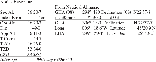
Nories
 $${\rm Hav}\,{\rm Zenith}\,{\rm Distance} = {\rm Hav(Lat}\sim {\rm Dec)} + {\rm Cos(Lat)}\,{\rm Cos(Dec)}\,{\rm HavLHA}$$
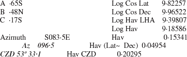
Pocket Calculator (Fundamental Cosine Formula)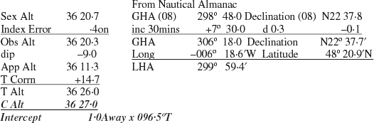
Pocket Calculator
 $${\rm Sin}\,{\rm Calc}\,{\rm Alt} = {\rm Cos}\,{\rm LHA}\,{\rm Cos}\,{\rm Lat}\,{\rm Cos}\,{\rm Dec} + {\rm Sin}\,{\rm Lat}\,{\rm Sin}\,{\rm Dec}$$
 $${\rm Sin}\,{\bi C}\,{\bi Alt} = {\cdot} 3066269676 + {\cdot} 2874862036 = {\rm Sin}\,36 {\cdot} 449 = {\rm Sin}\,{\bi 36}\deg\, {\bi 26{\cdot}96}'$$
- A
Tan Lat/Tan LHA=−·6488437479
- B
Tan Dec/Sin LHA=−·4811277043
- C
Cot Az×Sec Lat=·1677160436 Azimuth S83·5°E=093·5°T
Intercept Terminal Position

3.3. Underlying principles and practical reasoning
The above calculations were conducted to obtain a longitude, however to understand their accuracy a practical navigator must understand time and longitude. To previous generations with less concern about exactitude this was less of a problem but with the advent of atomic time and GPS this starts to have significance. Although to a practical navigator this need not be of concern to a surveyor or to a “Targeter” this has great significance. Starting with longitude and then time we must consider what is measured and where it is measured from.
3.3.1. Longitude measurement errors
The calculation of longitude should be easy; the longitude of a place is the angle between the plane of the prime (Greenwich) meridian and the meridian of the place measured east or west from the Greenwich Meridian, but where is the Greenwich Meridian? One would anticipate that it would pass though the Greenwich Observatory and indeed for the practical astro navigator it does, it passes through the Airy Transit Circle. The location of the Greenwich Meridian has been moved on several occasions in the last few centuries. Since the advent of GPS the Greenwich Meridian has been moved 103·3 metres east to match the requirements of the US Department of Defense. WGS 84, the Nautical Almanac and UT are based on this Prime Meridian.
3.3.2. Time errors
In the days of Flamsteed, time would be easy, it was simply based on the continuous observations of the time of Meridian Passage at the Greenwich Observatory; Airy measured these with his Transit Circle. An average time was calculated from this and this became Greenwich Mean Time. With the advent of Atomic Clocks and electronic communications, things have become much more complicated. For a fuller explanation see USNO (2012).
• TAI (Temps Atomique International=TAI). In 1958 TAI was matched with Solar Time (GMT at the Greenwich Observatory). It is now the weighted average of some 200 atomic clocks in over 50 national laboratories worldwide. The approximate difference between TAI and UT is now +67 seconds.
• UT (Universal Time). To the practical navigator UT is GMT and this is the time in which the Nautical Almanac is tabulated. GMT was calculated by astronomical observations. Today UT is generally taken to be UT1 which is UT corrected for polar wanderings (the movement of the Pole due to Precession and Nutation, etc) and measured by atomic clocks.
• UTC (Coordinated Universal Time). UTC is an arbitrary time advanced by an integral number of seconds from TAI so that the difference between UTC and UT1 is less than 0·9 s; to keep these two times close a leap second is used, the last was on 30 June 2012. It was introduced in 1972 and is the standard time from which most time is measured. The difference between UTC and UT1 was +0·3 sec in July 2012.
3.3.3. Significance to the practical navigator
The practical navigator usually considers GMT and UTC synonymous. He must, however, be aware of the inaccuracies in his position due to three longitude and time inaccuracies.
• The location of the Greenwich Meridian in WGS84.
• The difference between Atomic Time and Solar Time. Eg the difference between UTC (which is based on atomic time), UT1 (again based on atomic time) and GMT (which was a Solar Time).
• The difference between UTC and UT. Before 30 June 2012 this was −0·7078 secs and afterwards +0·2922 secs.
Differences between times on 1 July 2012:
 $$\matrix{ {{\rm TAI-UTC}} & {{\rm GPS-UTC}} & {{\rm UT1-UTC}} \cr { \hskip-8pt + 35\,{\rm secs}} & { \hskip-8pt + 16\,{\rm secs}} & { \hskip10pt + 0 {\cdot} 2922\,{\rm secs}} \cr} $$
• WGS 84 longitude is measured from a line 105 metres east of the Greenwich Observatory.
• UT1-UTC longitude correction is 0·3 secs late, assuming that UTC and UT1 are the same causes an error 92 metres west.
• The observed astro longitude was 006° 20′W this compares wth a GPS longitude (WGS 84) is 006° 18·6′W ie 1730 metres difference.
The practical navigator simply adopts the advice in Lecky (Reference Lecky1918c) on avoiding over precision:
“This attempt at exactitude, however praiseworthy in other respects, would often show an ignorance of governing principles which is one of the objects this book (Wrinkles) seeks to remove”.
Royal Navy (2008b) defines the accuracy requirement of Ocean Navigation as 2 nm. Using the definitions in this reference, there is no requirement for precise positioning until making a landfall.
4. CALCULATING POSITION FROM TWO POSITION LINES
EXAMPLE 5. SUN-RUN-SUN
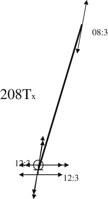
On the 6 July 2012 a position line was obtained at 08:30UT and a second position line at 12:30UT. 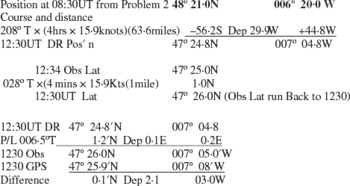
Sun-run-Sun with errors due to course and speed.

4.1. Difference between astro and GPS position
The difference between the Observed and GPS position was 290°×2·1 miles. However, this is as a result of a running fix: the position at 12:30UT is dependent on the course and distance that the ship has run between 08:30UT and 12:30UT. Both position lines are within 1 mile of GPS positions but the inaccuracy of course and speed have created a much less accurate position. The potential errors in the course are multiple and could be caused by compass error, helmsman error, steering high or low due to wind, leeway, tidal stream, current, etc. log error, tidal stream, current, etc could cause the error in the distance. A running fix is usually achieved by plotting and there are multiple opportunities for plotting errors.
4.2. Significance
The practical navigator can resolve many of these errors by the simple expedient of understanding the geometry of the astro running fix. Whereas to understand the accuracy of position lines it is useful to consider position lines in terms of latitude and longitude, a position line can be generated in many directions and a thinking navigator will always generate position lines in such a way that the errors caused by ship's movement are minimised.
EXAMPLE 6. SUN-RUN-SUN WITH NO SPEED ERROR
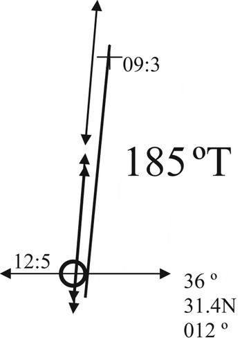
At 09:35:06 UT on 8 July 12 a sight of the Sun's Lower Limb was taken by sextant altitude 44° 58·6′ from a GPS pos'n of 37° 22·4′N 012° 02·1′W this was crossed with a Noon Sight giving a Latitude at 12:54UT of 36° 31·4N. 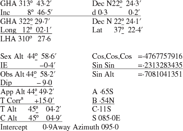
Sun-run-Sun with Sun.

4.3. Geometry
This Sun sight was taken on the beam and indicated that the ship was 8 cables to starboard of track. The position line was run up to the 1254 latitude where the position was calculated by plotting (36° 31·4N 012° 16·4W). This position was unaffected by Speed error and as the latitude was approximately at right angles to the course line it will confirm speed. The GPS position was 36° 31·8′N 012° 15·2′W.
4.4. Further improving accuracy
Although only a single sight was taken at 09:35 UT in this case, accuracy can be further improved by taking multiple sights (usually five or seven). Sharpey-Schafer (Reference Sharpey-Schafer1953) provides a description of this process. Two options are then available: either all intercepts are calculated and after obviously inaccurate intercepts are discarded, the remaining intercepts are averaged, or all altitudes are plotted on a graph against time and the best fit altitude is worked up to an intercept. This second method has the benefit that the graph of the altitude increase or decrease can be assessed against the Change of Altitude in One Minute of Time Table from Nories (1983).
5. CALCULATING POSITION FROM THREE OR MORE HEAVENLY BODIES VISIBLE AT THE SAME TIME (SIMULTANEOUS SIGHTS)
Notwithstanding the accuracy that is readily achievable with Sun sights, they have never held the kudos of Star sights. The main reason for this is that a solar position must nearly always take the form of a Sun-run-Sun (except in some special cases such as “Equal Altitudes” or “extreme high altitude sights”). Usually it is only at morning or evening twilight that multiple heavenly bodies can be observed.
5.1. Accuracy of stellar positions
High levels of accuracy have been claimed for stellar positions and automated stellar navigation systems have been used in defence systems such as the NAS-14V2 used in the SR71 and in ballistic missiles such as the US Trident system. Sharpey-Schafer (Reference Sharpey-Schafer1953) claimed accuracies of 1–2 nm, however elsewhere accuracies in the order of half a mile have been claimed.
5.2. RIN survey into accuracy of astro positions
In the 1950s the RIN conducted a survey of its members and calculated the accuracy of astro positions and published the following (RIN, 1957):
“SUMMARY OF CONCLUSIONS. The following conclusions relate to a total of 4245 observations received by the Working Party from 173 observers, and are representative of navigational practice as a whole only in so far as the observations, and the observers, are so representative. Only 3319 observations from 156 observers were retained as suitable for analysis, and in nearly half of these observations the ship's position is not known sufficiently accurately for them to be included in the main analysis. The errors, from all causes, to be expected in an astronomical position line in good conditions for observation are:

These figures are based on 1539 observations from 129 observers for the ‘average’ observer, and on 383 observations from 8 observers for the ‘best’ observer”.
A plethora of research has been conducted into the accuracies of celestial navigation and methods of improving it, see the 279 Institute of Navigation Articles listed by Starpath (2012).
5.3. Weaknesses in stellar positions
However accurate star sights are, they are extremely difficult to take in a small vessel in rough seas. The main weakness is the quality of the horizon; generally beginners will only see stars after or before an adequate horizon is available, and even experienced observers will not be able to obtain a good set of observations on many occasions. The accuracy of a first magnitude star or a planet taken with a good horizon will be significantly better than less bright heavenly bodies taken with a less distinct horizon. Practice does increase capability and even experienced observers will require the beginning of a voyage to “get their eye in”. Such is the motion of a ship across the oceans of the world that the stars chosen for one evening's observation will be almost identical with those selected for the following evening's observations. Experienced observers will grade position lines, often marking observations out of ten on the basis of experience and assess which position line can be relied on and which should be discarded. The quality of the horizon varies with azimuth, the best horizon will be easterly at the beginning of the observing period and westerly at the end of the observing period along the plane of sunrise/sunset.
On some rare occasions, a set of simultaneous sights can be achieved in daylight when Venus and the Moon are visible and a good horizon can be assured.
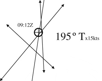
EXAMPLE 7. DAYLIGHT SIMULTANEOUS SIGHTS
Daylight Sun-Moon and Venus.

5.4. Horizon
The horizon by 09:00:00UT was easy to see, sharp and clear, both Venus and the Moon remained clearly visible. Two sights confirmed the GPS position (Venus and the Sun) with intercepts of below half a mile and the Moon's intercept was 4·3 nm Towards.
5.5. The Sun
Despite only one observation being taken, the Sun gave a small intercept. The refraction correction was small and individual corrections were used for greater accuracy. The Sun's position line was run back for nine cables to a time of 09:12UT.
5.6. Venus
Venus is the third brightest object in the sky after the Sun and Moon and is often too bright to give a good fix at twilight. If Venus is observed through a telescope it can be seen that it has phases akin to the moon. At twilight its actual size can cause an error; Venus is also subject to an irradiation error. If a bright object is observed against a darker background, a physiological effect in the eye causes the brighter object to appear larger than it actually is – this is an irradiation error. These errors are not corrected for in the Nautical Almanac and can cause Venus to be measured above its correct position. The Nautical Almanac additional correction for Venus is purely a parallax correction. A daylight sight of Venus will be more accurate than a twilight sight as Venus appears as a single spot of light. The observation of Venus confirmed the GPS position when it was run on one cable to 09:12UT.
5.7. The Moon
The Moon has long had a bad reputation with practical navigators: Burton (Reference Burton1952) states:
“Undoubtedly the lunar dog was first given its bad name, accidentally, though not entirely inculpably, by Captain Lecky. It has been said that Lecky contributed nothing to the advancement of the science of navigation; whether this is true or not, the fact remains that his Wrinkles in Practical Navigation was instrumental in bringing about a profound improvement in the general standard of navigational competence both in the Royal Navy and the Mercantile Marine.”
The Moon is subject to a variety of corrections. Due to its closeness to the Earth, it is an irregular timekeeper. The lunar time used by the Nautical Almanac Office (2012) is based on the rotation of the Earth through 360° in 25 hrs 08 mins 44 secs but the average lunar day is approximately 24 hrs and 50 mins; on any given day it can be more or less than the average. The lunar day is constantly changing in length and to correct for this effect, v is listed for every hour in the Nautical Almanac. The GHA and Dec corrected for v and d will give an accurate geographical position of the centre of the moon. However when a sight is taken of the moon it will be subject to small inaccuracies (in the order of cables) due to the augmentation of the semi-diameter of the moon being calculated for a spherical Earth rather than for a Geoid.
The Moon was observed when it was a Waning Crescent of 37%. The lower limb appeared visible, but the moon, although not subject to an irradiation error, was difficult to see against the relatively bright background of the sky. There was little contrast between the Moon and the sky and consequently the lower limb was not clearly defined: the result was that the intercept was 4·3 nm towards. The sight was run back by four cables to 09:12. The two position lines of the Sun and Venus confirmed the GPS position and the position line from the moon was discounted.
6. CONCLUSIONS
The Admiralty Manual of Navigation is a book of reference and when it defines the error of Astro Navigation as ±2 nm it seeks to present a definitive answer to what are in fact a great number of questions. This answer is presented so Ocean Navigation can be planned. This answer is derived from the simple process of summing a series of statistics and then presenting the mean as a definitive answer. If the statistics were de-aggregated it would be found that some of these position lines would be much more accurate than others. A more systematic approach to position lines would show that their accuracy would correlate with the azimuth of the heavenly bodies. On the basis of the speed of rotation of the Earth and the azimuth of heavenly bodies, intercepts will have errors which are proportional to Equation (2), repeated below:
 $$\eqalign{\ldquo {\rm error}\,{\rm in}\,{\rm intercept}\! \cr ({\rm due}\,{\rm to}\,{\rm time} \, {\rm error})\!\! } \eqalign {&= ({\rm error}\,{\rm in}\,{\rm HA}){\rm Sin}\,{\rm Azimuth}\,{\rm Cos}\,{\rm Latitude}. \cr &\ \ \ \ ({\rm due}\,{\rm to}\,{\rm time}\,{\rm error} )\rdquo} $$
It can therefore be assumed that latitude derived from astro will be more accurate than longitude.
If position lines were analysed on the basis of the bodies observed, it would also become apparent that the position lines obtained from brighter bodies would be more accurate than duller bodies – this is on the simple basis that the observer would be able to use a better horizon when observing brighter objects. In the NAS-14V2 star tracker used in the SR71, the system has ephemerides of the 61 brightest stars in its memory, but it locks onto only the three brightest objects every minute and achieves high accuracy by continuously monitoring these objects. Royal Navy (2011) concedes that if two objects are observed at 90° to each other an accuracy of ±1·5 nm could be achieved. In a similar manner, higher levels of accuracy can be achieved by the observer taking observations over longer periods and then averaging observations. For example, Van Der Grinten (Reference Van Der Grinten1975) claims accuracy of one cable from a position based on 42 observations.
Stellar Observations early in the evening or late in the morning will be more accurate as the quality of the horizon will be better. Observations taken on the best horizon ie east early in the observation period and west later in the observation period will present better results.
The practical navigator with the benefit of his experience can easily improve his accuracy by the systematic analysis of his results against anticipated errors. By the simple expedient of discarding poor observations on the basis of his previous experience, he can achieve more accurate results than those presented by the least square averaging techniques used in most computer astro systems. In addition he can use his knowledge to anticipate occasions where different approaches to astro will deliver better results by using different techniques when they present themselves e.g. daylight observations of the Moon and planets.
Bowditch (Reference Bowditch1984e) states:
“A well-constructed sextant is capable of measuring angles with an instrumental error not exceeding 0·1′. Lines of position from this accuracy would not be in error more than 200 yards. However there are various sources of error… … One of the principle sources is the observer himself. There is probably no single part of his work that the navigator regards with the same degree of professional pride as his ability to make good celestial observations. Probably none of his tasks require the same degree of skill. The first fix a student navigator obtains by the observation of celestial bodies is likely to be disappointing. Most navigators require a great amount of practice to develop the skill needed to make good observations. But practice alone is not sufficient, for if a mistake is repeated many times, it will be difficult to eradicate. Early in his career a navigator would do well to establish good observational technique – and continue to develop it during the remainder of his days as a navigator. Many good pointers can be obtained from experienced navigators.”
Astro navigation is a practical skill. The calculation and concepts behind astro can be taught ashore and they can be challenging for students, but they are only enabling skills. The actual key skills of a practical navigator can only be developed at sea. These skills can be self-taught, but only the exceptionally talented will achieve success in this manner. It is far easier for the student navigator to be taught by an experienced practical navigator at sea in a practical context. Unfortunately with the decline in the use of astro the number of these navigators is in sharp decline. As they decline, the anticipated accuracy of astro will also decline.