1. Introduction
It has been generally understood since the mid-1960s that the occurrence of high-pressure/low-temperature (high P/T) mineral assemblages in the largely Cretaceous Franciscan Formation of coastal California signalled the exhumation of these rock sequences from a depth of 20–30 km. It was reasoned that metamorphisms had occurred in the coolish subsurface setting of a subduction zone (Ernst, Reference Ernst1965, Reference Ernst1971 a, b, Reference Ernst1975). Other extensive exposures of exhumed high P/T rocks, and associated low P/T sequences, of early Tertiary, Mesozoic and late Palaeozoic age occur along other sectors of the eastern Pacific rim, for example, southern Chile (Gonzalez & Aguirre, Reference Gonzalez and Aguirre1970; Aguirre et al. Reference Aguirre, Herve and Godoy1972; Glodny et al. Reference Glodny, Esther, Figueroa, Franz, Gräfe, Kemnitz, Kramer, Krawczyk, Lehmann, Lucassen, Melnick, Matthias Roseau, Seifert, Once, Chong, Franz, Giese, Goetz, Ramos, Strecker and Wiggery2006; Angiboust et al. Reference Angiboust, Cambeses, Hyppolito, Glodny, Monié, Calderón and Caetano2018) and southern Alaska (e.g. Sample & Moore, Reference Sample and Moore1987; Plafker et al. Reference Plafker, Moore, Winkler, Plafker and Berg1994). It is generally acknowledged that both high and low P/T stratigraphic assemblages were subducted to their metamorphic depth and tectonically assembled (accreted) there before exhumation.
What is not generally recognized is that accretionary underplates at depths of up to 30+ km have been seismically identified at many Pacific subduction zones, for example beneath the forearcs of Chile, Colombia–Ecuador, Cascadia, Alaska, probably the Aleutian Islands, Japan and New Zealand. The intent of this paper is to call attention to this knowledge by reviewing and commenting on published seismic reflection and refraction data recorded at South and North American forearcs that imaged low-velocity rock sequences at subsurface depths >10 km. These bodies are now most commonly recognized as accumulated sediment transported to subcrustal depths in the subduction channel and added – under-accreted or underplated – to the base of the overlying forearc basement. Submerged basement is the offshore continuation of well-lithified, commonly intruded, coastally exposed basement rock. It is typically an exhumed, early Tertiary or older accretionary complex or a magmatically constructed massif, for example that of the Aleutian Arc (see Figs 8 and 10 below for documenting information). In the offshore, forearc basement is unconformably overlain by younger, weakly consolidated and little-deformed shelf and trench-slope deposits (Figs 1 and 2).
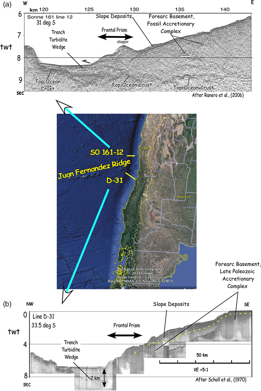
Seismic reflection profiles that cross the axis of the south-central Chile Trench at (a) ∼31° S (after Ranero et al. Reference Ranero, von Huene, Weinrebe, Reichert, Once, Chong, Franz, Giese, Goetz, Ramos, Strecker and Wiggery2006) and (b) ∼33.5° S (after Scholl et al. Reference Scholl, Christensen, von Huene and Marlow1970). Both sections image 1–2 km thick axial wedges of turbidite deposits and adjacent, narrow 5–20 km wide frontal accretionary prism.

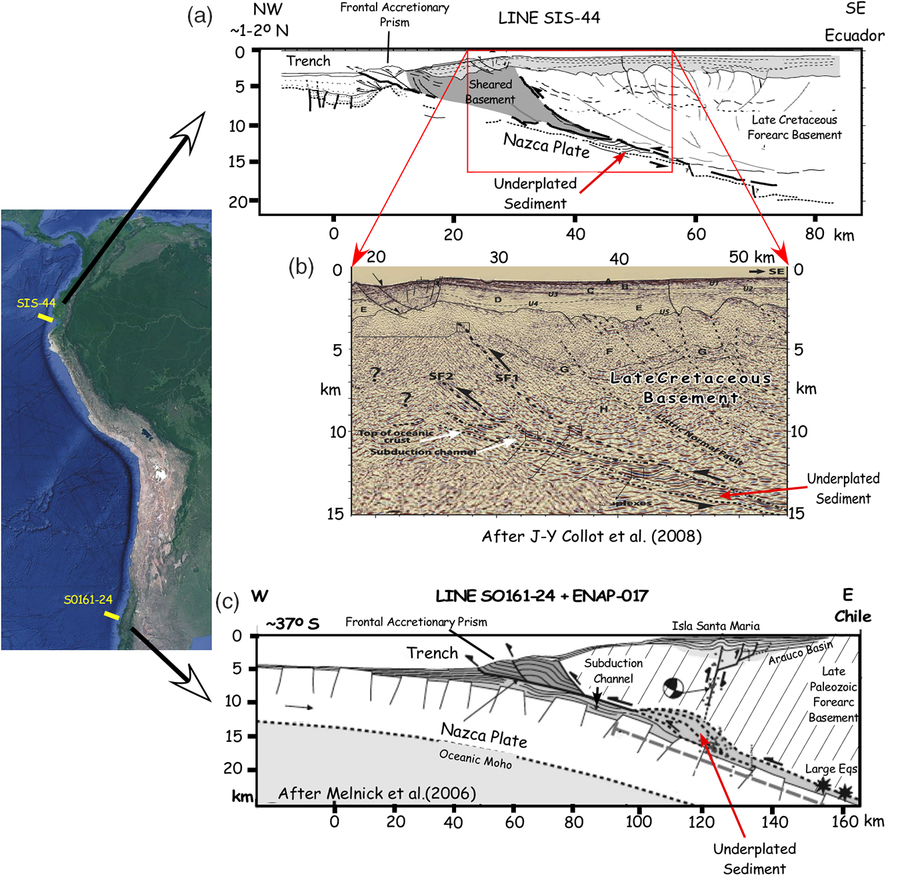
(a) Interpreted drawing of seismic reflection record collected across the Colombia–Ecuador forearc at ∼1–2° N; (b) seismic image of sediment underplated below the Colombia–Ecuador shelf (Collot et al. Reference Collot, Agudelo, Ribodetti and Marcaillou2008); and (c) drawing of seismic record at ∼37°S interpreted to show underplated sediment below the south-central Chile shelf (Melnick et al. Reference Melnick, Bookhagen, Esther and Strecker2006).

Underplating can also occur beneath the frontal prisms of weakly consolidated trench sediment accreted to the seaward edge or front of submerged forearc basement (Figs 1, 2). This paper, however, primarily addresses seismic evidence for underplating at depths >10–20 km beneath an overlying lid of forearc basement. As noted, underplated subcrustal masses at >∼10 km are generally thought to be mostly subducted sediment mixed in with tectonically eroded debris. The physical existence of these imaged masses supports the view that high and low P/T metamorphic bodies are exhumed accretionary underplates, the higher-grade facies from deeper beneath a lid of forearc basement.
1a. Initial accretionary imaging
In the late 1960s and early 1970s marine seismic reflection profiles collected across the lower forearc slope of all well-sedimented subduction zones imaged a landward-thickening, wedge-shaped prism of weakly consolidated trench-floor sediment (see e.g. Chase & Bunce, Reference Chase and Bunce1969; Scholl et al. Reference Scholl, Christensen, von Huene and Marlow1970; Silver, Reference Silver1972; Moore & Karig, Reference Moore and Karig1976). The inner (landward) part of the frontal prism (wedge) could be seismically imaged to a subsurface depth of a few to perhaps 4–5 km. Because of the limited acoustic power and short echo-receiving cables then available to academia and government research vessels, imaging of accretionary bodies that had accumulated at subsurface depths matching that of either exhumed low P/T (5–10 km) or high P/T (20–30 km) metamorphic grade was not achievable. Hence, seismic verification of underplated accumulations was not possible.
However, in ∼1981 the US Geological Survey (USGS) was requested to investigate a late 1970s report by Sankey Blanton of Sun Oil Company of the possible imaging by this company of the Pacific plate subducting beneath the southern Alaska forearc. A consequent deep-crustal imaging experiment was conducted with the USGS multichannel seismic vessel S. P. Lee across the inner shelf area east of Kodiak Island (see Figs 6 and 7 below for related information). Deep subcrustal reflections were recorded that Fisher et al. (Reference Fisher, von Huene, Smith and Bruns1983) conjectured were either returns from the subducting Pacific plate or a detached (underplated) piece of its oceanic crust. Later, Byrne (Reference Byrne1986) and Fisher et al. (Reference Fisher, von Huene and Smith1987) considered these reflections from subducted sediment or rock accreted (underplated) between the subducting and overlying plates.
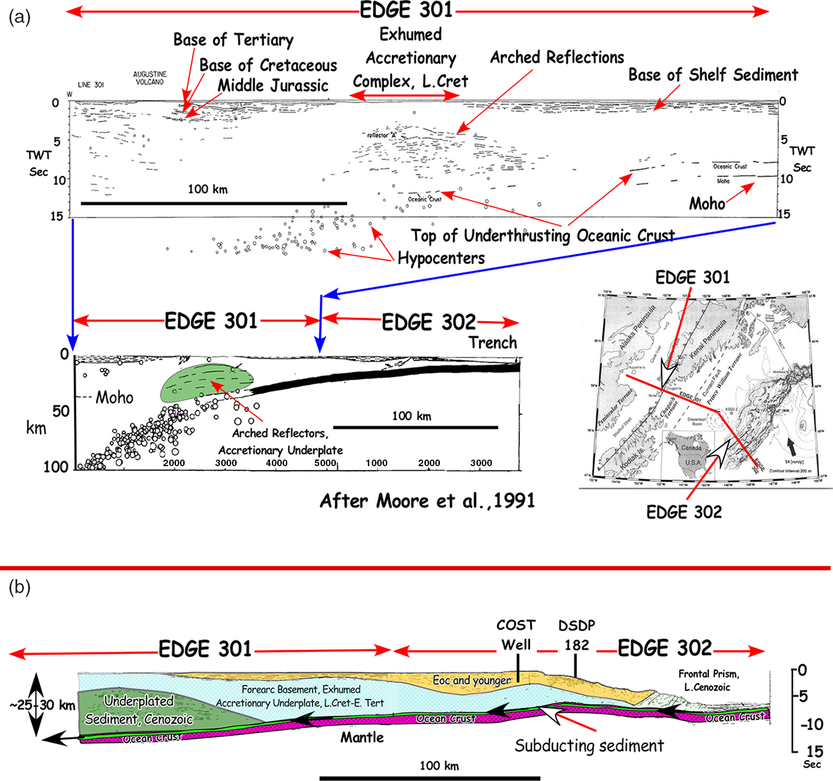
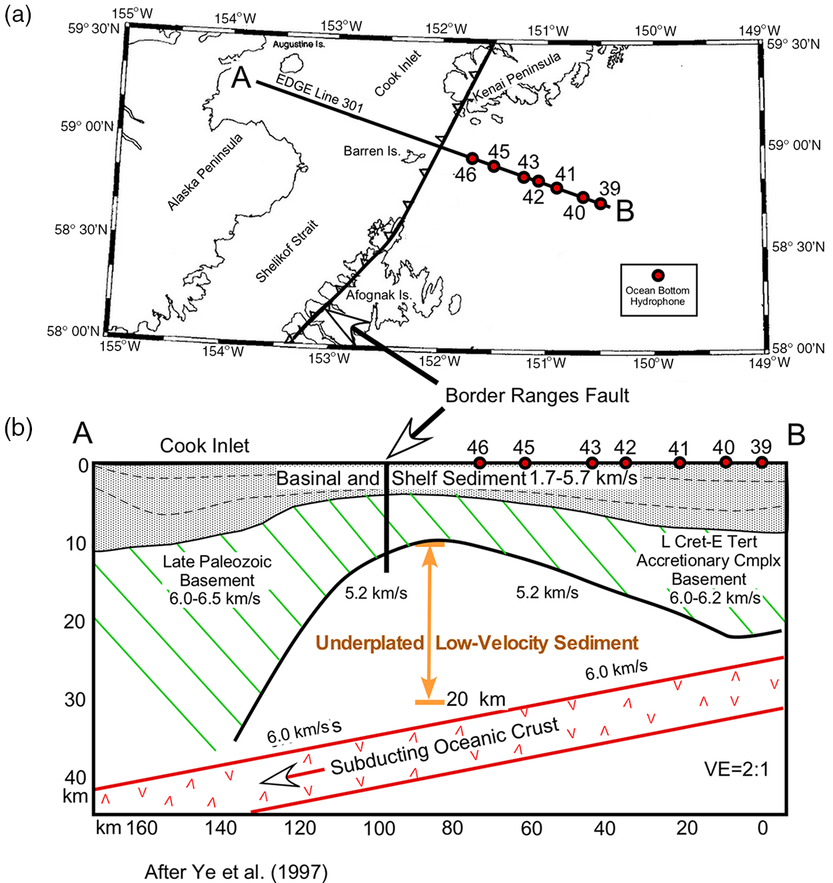
In 1989, with funding provided by the National Science Foundation (NSF)’s Enabling Discovery through Genomic Tools (EDGE) programme, US academia chartered an industry vessel with sufficient cable length and acoustic power to more fully image deeply beneath the submerged Alaska forearc, the upper slope and shelf of which is underlain by an exhumed accretionary complex of early Tertiary and Late Cretaceous age. The EDGE line traversed the southern Alaska forearc from trench floor NW to and across the Cook Inlet forearc basin (see Figs 6 and 7 below for locating information). In the coastal region between Kodiak Island and the tip of the Kenai Peninsula, deep reflections imaged a ∼25 km thick sequence of broadly arched reflection horizons extending from a subsurface depth of ∼10 to 35 km. The stack of reflection horizons was interpreted as most likely a sequence of basement underplated sediment (Moore et al. Reference Moore, Diebold, Fisher, Sample, Broacher, Talwani, Ewing, von Huene, Rowe, Stone, Stevens and Sawyer1991; Ye et al. Reference Ye, Flueh, Klaeschen and von Huene1997).
Since recording of the Alaska EDGE transect, other deep-penetrating seismic profiles have imaged Pacific forearc bodies interpreted as underplated sedimentary and possibly igneous rock at subsurface depths >∼10–15 km. For the Americas, seismic images of underplates have been recorded beneath the southern Chile, Colombia–Ecuador, Cascadia, Alaska and probably the Aleutian forearcs. In this south-to-north order, seismic evidence is described below for the reported imaging of underplated material accreted below the upper slope, shelf and coastal areas of eastern Pacific and Alaska subduction zones.
If exhumed, many of those underplates detected at subsurface depths of only ∼10 km could emerge as belts of high P/T metamorphic assemblages. This circumstance reflects the fact that at many forearc margins a substantial erosional unconformity has been cut across forearc basement documenting the removal of 10 or more km of crust from the shelf area and much of the forearc slope (Figs 1, 2 and 6, 7, 8 below).
2. Underplated eastern and north Pacific forearcs
2.a. Southern Chile and Colombia–Ecuador forearcs
South of ∼33° S, the Chile Trench, as it is now, has probably been thickly (2–4 km) filled with sediment since the beginning of the ice-age Quaternary at ∼2.6 Ma (Fig. 1). Only a narrow, 10–40 km wide frontal prism of accreted trench sediment has accumulated seaward of forearc basement (Scholl et al. Reference Scholl, Christensen, von Huene and Marlow1970; Bangs & Cande, Reference Bangs and Cande1997; Ranero et al. Reference Ranero, von Huene, Weinrebe, Reichert, Once, Chong, Franz, Giese, Goetz, Ramos, Strecker and Wiggery2006; Polonia et al. Reference Polonia, Torelli, Francolin and Loreto2007). Forearc basement off south-central and southern Chile is constructed largely of exhumed high P/T accretionary complexes of Late Palaeozoic to Mesozoic age (Gonzalez & Aguirre, Reference Gonzalez and Aguirre1970; Aguirre et al. Reference Aguirre, Herve and Godoy1972; Glodny et al. Reference Glodny, Esther, Figueroa, Franz, Gräfe, Kemnitz, Kramer, Krawczyk, Lehmann, Lucassen, Melnick, Matthias Roseau, Seifert, Once, Chong, Franz, Giese, Goetz, Ramos, Strecker and Wiggery2006; Angiboust et al. Reference Angiboust, Cambeses, Hyppolito, Glodny, Monié, Calderón and Caetano2018). Thus, at least periodically, accretionary underplating has been taking place along the southern Chile forearc since at least ∼310 Ma.
It is estimated that since ∼2.6 Ma an average thickness of trench sediment of ∼2 km has been entering the southern Chile subduction zone (von Huene & Scholl, Reference von Huene and Scholl1991; Scholl & von Huene, Reference Scholl, von Huene, Hatcher, Carlson, McBride and Martínez2007). At an average orthogonal convergent rate of 60 km Ma−1, a volume of undrained Quaternary-age trench sediment of ∼300 km3 has entered each km of subduction zone. This volume is just a little less than ten times that typical of the undrained volume of the accreted frontal prism (35–40 km3). A large volume of sediment has thus bypassed storage in the frontal prism and continued onward in the subduction channel beneath the submerged forearc.
Added to this volume of subducted material is tectonically eroded debris from the submerged forearc. The volume erosion rate for the Chile subduction zone is estimated at ∼60 km3/Ma/km-trench (Scholl & von Huene, Reference Scholl, von Huene, Hatcher, Carlson, McBride and Martínez2007). Thus, during the Quaternary, an additional volume of 150 km3/km-trench, for an estimated total of 450 km3/km-trench, has been subducted beneath the forearc margin toward the mantle. The tectonic fate of this material is to either (1) underplate the upper plate, enter the mantle to (2) melt and be recycled to the upper plate as arc magma, or (3) enter into deeper mantle circulation. For the South American margin, Kay et al. (Reference Kay, Godoy and Kurtz2005) argued that the bulk of subducted sediment and tectonically eroded debris entered into mantle circulation, only a small fraction of which melted (Kay et al. Reference Kay, Goss and Mulcahy2012; Goss et al. Reference Goss, Kay and Apodosis2013).
South of ∼33° to ∼56°, seismic reflection profiles of sufficient power to detect underplated bodies have been collected across the South American forearc adjacent to the sediment-flooded (2–3 km) southern Chile and Patagonian Trenches (Bangs & Cande, Reference Bangs and Cande1997; Ranero et al. Reference Ranero, von Huene, Weinrebe, Reichert, Once, Chong, Franz, Giese, Goetz, Ramos, Strecker and Wiggery2006; Polonia et al. Reference Polonia, Torelli, Francolin and Loreto2007; Volker et al. Reference Volker, Geersen, Contreras-Reyes, Sellanes, Pandora, Rabbel, Thrower, Reichert, Block and Weinrebe2012; Zhang et al. Reference Zhang, Trehu, Bangs and Contreras-Reyes2018). Examining reflection data gathered by R/V Sonne on Line SO161-24 (∼37° S), Melnick et al. (Reference Melnick, Bookhagen, Esther and Strecker2006) surmised that uplift of the shelf area formed Isla Santa María (∼37° S). Uplift is linked to high-angle reverse faulting that extends upward and landward from a subsurface depth of ∼13 km. In Figure 2a, a line drawing sketch of the high-angle fault is shown rooted atop a 10–15 km thick body of underplated sediment underlying a forearc basement of late Palaeozoic metasediment.
Further north between ∼30° S and ∼40° S, Zhang et al. (Reference Zhang, Trehu, Bangs and Contreras-Reyes2018) described crustal reflections deep (>10–15 km) beneath the upper continental slope and shelf area. Considering the large volume of subducted sediment not retained in the frontal prism, the notion has to be entertained that the deep reflection horizons image underplate sediment and tectonically eroded debris beneath a forearc basement of Mesozoic age.
In northern Chile and Peru, Hartley et al. (Reference Hartley, May, Chong, Turner, Kape and Jolly2000) and Clift & Hartley (Reference Clift and Hartley2007) cite late Cenozoic coastal uplift as evidence of coastal-area underplating, despite the circumstance that little sediment is subducted beneath this forearc (Scholl & von Huene, Reference Scholl, von Huene, Hatcher, Carlson, McBride and Martínez2007; Scholl et al. Reference Scholl, Kirby, von Huene, Ryan, Wells and Gist2015). Still further to the north, inboard of the sediment-flooded southern Colombia–Ecuador sector of the Peru–Chile Trench (1–2° N), Collot et al. (Reference Collot, Agudelo, Ribodetti and Marcaillou2008) documented sediment underplating forearc basement at depths of ∼10–15 km below mid- and outer shelf areas (Fig. 2a). Forearc basement here is an accreted Late Cretaceous oceanic terrane – probably an oceanic plateau (Collot et al. Reference Collot, Agudelo, Ribodetti and Marcaillou2008). Considering the thickness of trench-filling sediment (3–4 km), it seems reasonable to suppose that larger and thicker bodies of underplated sediment may reside further landward beneath the un-imaged inner shelf and coastal area.
2.b. Northern Cascadia, Vancouver Island, British Columbia
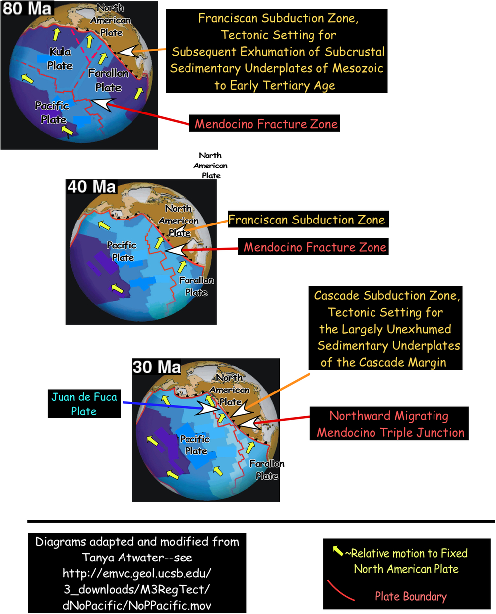
It is widely recognized that the type Pacific-rim subduction complex is the Franciscan Formation of coastal California (Bailey et al. Reference Bailey, Irwin and Jones1964; Ernst, Reference Ernst1965, Reference Ernst1971 a, Reference Ernst1975). From the Late Jurassic to the mid-Tertiary, large volumes of the exposed Franciscan exhibiting high P/T metamorphism accumulated as deep (>∼20 km) crustal underplates, including beneath the Sierran Arc (Ducea et al. Reference Ducea, Kidder, Chesley and Sleepy2009; Ducea & Chapman, Reference Ducea and Chapman2018). Beginning ∼30–35 Ma, northward-progressing termination of subduction at the Franciscan subduction zone occurred beneath northern California south of the north-migrating Mendocino triple junction (Fig. 3). Subduction of the Juan de Fuca plate at the sediment well-supplied Cascade subduction zone (Fig. 4), the tectonic remainder of the Franciscan subduction zone, continued north of the triple junction (Silver, Reference Silver1972; Snavely, Reference Snavely, Scholl, Grants and Vedder1987; Flueh et al. Reference Flueh, Fisher, Bialys, Childs, Klaeschen, Kukowski, Parsons, Scholl, ten Brink, Trehu and Vidal1998).
Diagram shows progressive (80–30 Ma) eastward subduction of the Farallon plate into the Franciscan subduction zone. At ∼35 Ma, with collision of the Mendocino Fracture Zone with the North American plate, subduction of the Farallon plate into Franciscan subduction zone ended north of the northward-migrating Mendocino triple junction. Convergence continued, however, with subduction of the Juan de Fuca plate into the Cascade subduction zone. South of the triple junction, underplated Franciscan sediment of Mesozoic to Early Tertiary age was widely exhumed along much of coastal North America. North of the triple junction, relatively little sediment accreted (underplated) beneath the Cascade forearc has been exhumed (Brandon et al. Reference Brandon, Roden-Tice and Garver1998).

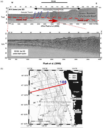
(a) Interpreted multichannel seismic reflection profile 103 collected by R/V Sonne across the sediment-filled Cascade Trench underthrust by the subducting Juan de Fuca plate (see Fig. 3). (b) Location of Line 103 off the Washington coast of the United States. Dots and squares indicate locations of ocean bottom hydrophones and seismometers, respectively. Seismic section and map after Flueh et al. (Reference Flueh, Fisher, Bialys, Childs, Klaeschen, Kukowski, Parsons, Scholl, ten Brink, Trehu and Vidal1998).

Considering the wide exposure of exhumed Franciscan complex south of the triple junction of both low and high P/T metamorphic history (Ernst & McLaughlin, Reference Ernst and McLaughlin2012), it has to be presumed that north of the triple junction underplating of subducted sediment and eroded debris to depths of 5–30 km continued below the Cascade forearc. Although the Cascade subduction zone formed in the early Eocene (see recent review by Stern & Dumitru, Reference Stern and Dumitru2019), crustal basement of the sediment-charged Cascade forearc is constructed of early Eocene and older igneous rock widely exposed along the Oregon, Washington and Vancouver British Columbia coastal area (Snavely, Reference Snavely, Scholl, Grants and Vedder1987; Flueh et al. Reference Flueh, Fisher, Bialys, Childs, Klaeschen, Kukowski, Parsons, Scholl, ten Brink, Trehu and Vidal1998) (Fig. 4).
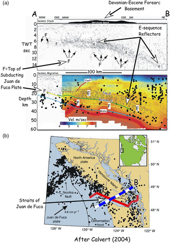
Initial evidence of deep subcrustal underplating beneath the Eocene and older basement rock exposed on Vancouver Island was reported by Yorath et al. (Reference Yorath, Green, Clowes, Sutherland Brown, Brandon, Kanesewich, Hyndman and Spencer1985). They described reflection imaging of a ∼5–8 km thick sequence of landward-dipping reflection horizons, the E-sequence, at a subsurface depth >∼20 km (Fig. 5). The E-horizons have been interpreted as an imbricated stack of mafic and sedimentary rock (Green et al. Reference Green, Clowes, Yorath, Spencer, Kanesewich, Brandon and Brown1986), a body of underplated sediment (Clowes et al. Reference Clowes, Brandon, Green, Yorath, Brown, Kanesewich and Spencer1987) and a zone of sheared crustal rock zone (Calvert et al. Reference Calvert, Fisher, Ramachandran and Tre´hu2003; Calvert Reference Calvert2004). More recently, seismic tomography documented a low-velocity zone overlying subducting oceanic crust. The low-velocity zone appears to include some or perhaps much of the E-reflectors and is interpreted as including accreted (underplated) sediment (Calvert et al. Reference Calvert, Preston and Farahbod2011). Considering the thick (2–4 km) body of sediment entering the Cascade subduction zone, and the surface exposure of exhumed underplate in the Olympic Mountains (Brandon et al. Reference Brandon, Roden-Tice and Garver1998), it seems likely that the E-reflectors may include an abundance of underplated sediment.
(a) Drawing of seismic profile recording E-sequence reflection horizons imaged beneath the Strait of Juan de Fuca along irregular red line (see b) and projected beneath Vancouver Island of the Cascade forearc along the straight blue-and-white dashed line (see b). Black dots are earthquake hypocentres. E-sequence is ∼15 km thick and probably composed mostly of low-velocity sediment underplated beneath the Cascadia’s forearc basement exposed on Vancouver Island (Calvert et al. Reference Calvert, Preston and Farahbod2011). (b) Index map showing line of seismic recording (red) and line of projection beneath Vancouver Island (dashed blue and white). Black dots are earthquake epicentres (after Calvert, Reference Calvert2004).

(a) Interpreted line drawings of contiguous EDGE seismic reflection Lines 301 and 302 recorded across the Kodiak area forearc of southern Alaska. Drawing shows a ∼25 km thick sequence of arced reflection horizons inferred to image a subcrustal (forearc basement) body of mostly underplated sediment (Moore et al. Reference Moore, Diebold, Fisher, Sample, Broacher, Talwani, Ewing, von Huene, Rowe, Stone, Stevens and Sawyer1991; see also Fig. 7). (b) Interpreted structural section along Lines 301 and 302.

(a) Seismic refraction line collected along the southern Alaska EDGE Line 301. (b) Interpreted sketch of refraction Line 301 showing a volumetrically large (∼2000 km3/km of margin) mass of underplated, low-velocity sediment beneath the inner shelf of the southern Alaska forearc. Diagram modified after Ye et al. (Reference Ye, Flueh, Klaeschen and von Huene1997).

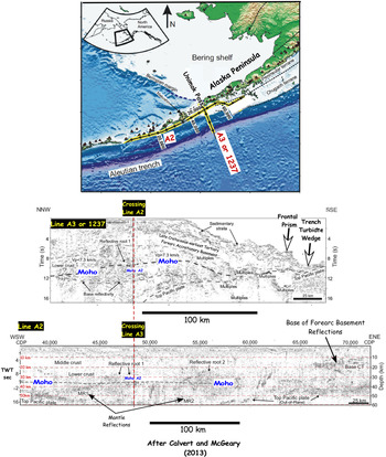
Line drawing of R/V Ewing multichannel seismic Lines A3 (also 1237) and A2 by Calvert and McGeary (Reference Calvert and McGeary2013). A3 crosses the continental crust off the SW tip of the Alaska Peninsula and extends southward to the Alaska Trench. Line A2 traverses southwestward from the Permo-Triassic and younger continental crust of the Alaska Peninsula onto the structurally connected Eocene and younger igneous massif of the Aleutian Arc. Lines A2 and A3 image 20 to- ∼60 km deep subsurface reflections, including sub-Moho returns from within the upper mantle. These have been interpreted as most likely returns from intrusive mafic and ultramafic bodies (Calvert & McGeary, Reference Calvert and McGeary2013). However, considering the large volume of sediment that has underthrust this contiguous forearc margin, and the implications of the imaging of a large subcrustal mass of underplated sediment along the EDGE Line recorded to the NE (Figs 6 and 7), it seems likely that the deep subsurface reflections recorded along Lines A2 and A3 also include a large volume of underplated sediment.

2.c. Southern Alaska
As described in the introductory section, the initial non-industry seismic detection of a subcrustal body of hypothesized underplated sediment was made in 1981 beneath the submerged coastal forearc of the Alaska subduction zone (Fisher et al. Reference Fisher, von Huene, Smith and Bruns1983, Reference Fisher, von Huene and Smith1987; Byrne, Reference Byrne1986). A follow-on seismic reflection study in 1989 by an NSF-charted industry vessel conducting the EDGE traverse of the Kodiak shelf was able to more definitely image a domed, 25 km thick sequence of deep (10–35 km) reflection horizons. A seismic tracing in reflection time of the deep horizons is shown in Figure 6. Two drawings in depth are also shown. Their emplacement was attributed to sediment underplating above the subducting Pacific plate and beneath a forearc basement of an exhumed Late Cretaceous to early Tertiary accretionary complex (Moore et al. Reference Moore, Diebold, Fisher, Sample, Broacher, Talwani, Ewing, von Huene, Rowe, Stone, Stevens and Sawyer1991). Subsequent ocean-bottom refraction studies along the EDGE traverse determined that the sequence was a low-velocity zone, confirming it was a large body of underplated sediment that probably included tectonically eroded debris (Ye et al. Reference Ye, Flueh, Klaeschen and von Huene1997) (Fig. 7).
2.d. Southwestern Alaska and eastern Aleutian Islands
In 1994, R/V Ewing recorded multichannel seismic Line 1237 across the submerged continental shelf off the SW tip of the Alaska Peninsula (Fig. 8). Line drawing interpretations of this line to a maximum subsurface depth of ∼10 km, which did not reveal reflections from a crustal underplate, were subsequently published by von Huene et al. (Reference von Huene, Miller and Weinrebe2012, Reference von Huene, Kirby, Miller and Darnell2014). Calvert and McGeary (Reference Calvert and McGeary2013), however, identified reflective returns from subsurface depths of 35–40 km beneath a forearc basement of an exhumed and intruded Late Cretaceous to early Tertiary accretionary complex (Fig. 8). The deep subcrustal reflections were interpreted as most likely generated by mafic and ultramafic intrusive bodies.
The axis of the Alaska Trench crossed by Line 1237, labelled by Calvert and McGeary (Reference Calvert and McGeary2013) as Line A3, is thickly filled (∼2.5 km) with turbiditic sediment (Scholl, Reference Scholl, Burk and Drake1974; von Huene et al. Reference von Huene, Miller, Klaeschen and Darnell2017). As shown in Figure 8, Line A2 runs NE–SW along the submerged southern shelf area of the western end of the continental crust of the Alaska Peninsula. At Unimak Pass, Line A2 crosses Line A3, and continues southwestward along the southern shelf area or summit platform (Scholl et al. Reference Scholl, Vallier, Stevenson, Scholl, Grants and Vader1987) of the structurally contiguous igneous massif of the Aleutian Arc. South of Unimak Pass, the axes of the Alaska and Aleutian Trenches structurally and bathymetrically merge (Fig. 8).
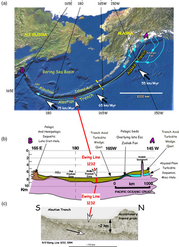
Sediment filling of the Aleutian Trench was presumably by westward, down-axis flow of turbidity currents from the Alaska Trench (Fig. 9). Sediment flooding may have been quasi-continuous during much of glacial-age Cenozoic time (i.e. since ∼2.6 Ma), but axial filling may have started earlier in the late Miocene when alpine glaciation got underway in mountainous SE Alaska (Eyles et al. Reference Eyles, Eyles, Lagoe, Anderson and Ashley1991). Because the accretionary frontal prism adjacent to the Alaska Peninsula is only ∼20–30 km wide (von Huene et al. 2012, Reference von Huene, Miller, Klaeschen and Darnell2017), a large volume of trench-axis sediment must have been subducted beneath the Late Cretaceous and early Tertiary rock framework of the Alaska forearc (Fig. 8). Considering the large body of underplated sediment imaged along the southern Alaska EDGE Line (Figs 6, 7), it seems probable that subcrustal reflections, for example the ‘reflective roots’ recorded along Lines A2 and A3 (Fig. 8), may also have imaged underplated sediment, and potentially large masses.
(a) Sediment-transporting turbidity currents (blue arrows) sourced from glaciated Alaska drainages flow westward down the axis of the Alaska Trench to the Aleutian Trench. (b) From A–B (see a), axial sedimentary section of the Alaska–Aleutian Trench fill showing that turbiditic sediment largely sourced from Alaska drainage is continuous as far westward as Attu Island (∼172° E). (c) Seismic reflection cross-section of Aleutian Trench axis at ∼172° W shows landward-thickening wedge of turbidite deposits as thick as ∼2 km (Scholl, Reference Scholl, Burk and Drake1974; Scholl et al. Reference Scholl, Vallier, Stevenson, Scholl, Grants and Vader1987; Ryan et al. Reference Ryan, Draut, Keranen and Scholl2012). Large white arrows show underthrusting vector of Pacific plate relative to a fixed North American plate (i.e. Aleutian Arc).

With respect to this possibility, Line A2 displays reflection events that are as deep as (20–30+ km) the well-imaged E-reflectors beneath the Vancouver Island area of the Cascade forearc (Fig. 5). At each of the Vancouver, southern and southwestern Alaska, and eastern Aleutian forearcs, deep reflective bodies directly overlie the subducting plate. This observation is compatible with the conjecture that the reflective bodies are subducted material underplated or accreted at depth.
2.e. Central Aleutian Islands
Intra-oceanic subduction zones (e.g. the Izu–Bonin, Tonga, Kermadec, Vanuatu, Solomon, Lesser Antilles systems) are typically remote from sediment-supplying continental drainages. As a consequence, trenches of intra-oceanic subduction zones are characteristically sediment-poor. However, this is not the circumstance for the intra-oceanic Aleutian Trench, because it is connected to glaciated Alaska drainages via the sediment-charged Alaska Trench (Scholl, Reference Scholl, Burk and Drake1974). As shown diagrammatically in Figure 9a, Alaska-sourced turbidity currents reaching the axis of the Alaska Trench flow westward in the direction of increasing crustal age or water depth (Atwater & Severinghaus, Reference Atwater, Severinghaus, Winterer, Hussong and Decker1989) to flood the structurally contiguous Aleutian Trench with an arcward-thickening wedge of continent-derived sediment (Fig. 9a, b, c).
Westward along the Aleutian subduction zone, convergence between the Pacific- and North American plates becomes increasingly oblique and virtually trench-parallel west of Attu Island (∼172° E) (Fig. 9a). Sediment thickness is greatest along the eastern half of the Aleutian Trench (∼180–165° W) where the average orthogonal underthrusting rate is ∼45 km Ma−1 (von Huene & Scholl, Reference von Huene and Scholl1991; Scholl & von Huene, Reference Scholl, von Huene, Hatcher, Carlson, McBride and Martínez2007). Because the width and volume of the frontal accretionary prism are small (20–30 km and ∼30 km3/km of margin, respectively), a larger amount of sediment has been subducted beneath the forearc’s Eocene arc magmatic basement. Subducted sediment and tectonically eroded forearc debris have either underplated the forearc crust or continued on into the mantle.
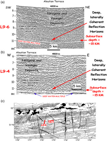
Although seismic evidence for forearc underplating has not been directly stated, laterally coherent, deep crustal or subcrustal reflection horizons (bands) have been reported below the deep-water (∼4500 m) Aleutian Terrace (Ryan & Scholl, Reference Ryan and Scholl1993). The horizons were recorded at a subsurface depth of ∼10 km and deeper (i.e. at sub-sea level depths of ∼15 km and greater). Two examples of these multichannel seismic recordings, Lines L9-6 and L9-4, are shown in Figure 10. Although originally thought to be reflections generated from or near the interplate surface (Ryan & Scholl, Reference Ryan and Scholl1993), deep reflection returns recorded along the EDGE and Ewing Lines A2 and A3 (Figs 6, 7, 8) imply that the top of a sequence of underplated sediment may have been imaged beneath the Aleutian Terrace.
3. Summarizing remarks
More than half a century ago field and mineralogical studies established that high-grade metamorphic rocks of coastal California’s Franciscan Formation had been exhumed from a depth of 20–30 km from the cooled subsurface setting of a now-abandoned, largely Mesozoic subduction zone (Ernst, Reference Ernst1965, Reference Ernst1971 a, b, Reference Ernst1975). Notwithstanding this understanding, not until the 1980s did deep seismic imaging of the active Alaska subduction zone confirm the existence at a depth of 10–35 km of a voluminous subsurface body (∼2100 km3/km of margin) of accreted sediment (Fisher et al. Reference Fisher, von Huene, Smith and Bruns1983; Byrne, Reference Byrne1986; Moore et al. Reference Moore, Diebold, Fisher, Sample, Broacher, Talwani, Ewing, von Huene, Rowe, Stone, Stevens and Sawyer1991; Ye et al. Reference Ye, Flueh, Klaeschen and von Huene1997). Subcrustal stratified bodies of underplated material have since been reported from other North and South American subduction zones, for example southern Chile, Colombia–Ecuador, Cascadia, SE and SW Alaska and possibly the Aleutian Islands. Forearc underplates have also been reported from western Japan (Park et al. Reference Park, Tsuru, Takahashi, Hori, Kodaira, Nakanishi, Miura and Kaneda2002; Kimura et al. Reference Kimura, Takeda, Obara and Kasahara2010) and North Island, New Zealand (Sutherland et al. Reference Sutherland, Stagpoole, Ruska, Kennedy, Bassett, Henrys, Scherwath, Kopp, Field, Tooling, Barker, Bannister, Davey, Stern and Flueh2009; Bassett et al. Reference Bassett, Sutherland, Henrys, Stern, Scherwath, Benson, Toulmin and Henderson2010).
Questions arise as to the age, or ages, when underplating took place and the sort of material involved. All of the forearcs beneath which large underplates at subsurface depths of ∼10–30+ km have so far been imaged are low-velocity bodies located along well-sedimented subduction zones. It thus seems likely that imaged subcrustal underplates include large amounts of subducted sediment. Subduction erosion also occurs at these margins (Scholl & von Huene, Reference Scholl, von Huene, Hatcher, Carlson, McBride and Martínez2007), hence underplated bodies at depth probably include debris derived from forearc erosion. This likelihood is supported by the trace-element geochemistry of arc volcanic products (Kay et al. Reference Kay, Godoy and Kurtz2005, Reference Kay, Goss and Mulcahy2012; Goss et al. Reference Goss, Kay and Apodosis2013; Straub et al. Reference Straub, Gomez-Tuna, Bindeman, Bolge, Brandl, Espinasa-Perena, Solaria, Stuart, Vannucchi and Zellmer2015; Parlor et al. Reference Parlor, Gómez-Tuena, Cavazos-Tovar and Hernández-Quevedo2018).
If seismic images of identified underplated material are indeed limited – or mostly so – to sediment-nourished subduction zones, and most thick (>1–2 km) trench fills reflect enhanced rates of glacial-age turbiditic sedimentation (von Huene & Scholl, Reference von Huene and Scholl1991), then some (many?) underplates may reflect the increased supply of glacial-age sediment to trench axes. But this cannot be presumed for subduction zones reached by long-established river systems. For example, sediment subduction at the Cascade forearc has been ongoing since at least the late Eocene (∼40 Ma) (Brandon & Vance, Reference Brandon and Vance1992). Hence it seems likely that the structurally higher part of the ∼10 km thick E-reflectors of interpreted underplated sediment beneath Vancouver Island could include early Cenozoic sediment (Fig. 5).
Subduction at the Alaska Trench has been ongoing since at least the early Mesozoic when now exhumed subduction complexes that include high P/T units were underplated at subsurface depths of 20–30 km (Connelly, Reference Connelly1978). These rocks are exposed on Kodiak Island and adjacent insular and mainland areas. Sediment subduction has thus been active and voluminous along the Alaska subduction zone during much of the Mesozoic and early Cenozoic and well before enhanced Quaternary delivery of sediment to the Alaska–Aleutian trench system.
Estimating the long-term average volume of material subducted beneath the Alaska forearc during just the Cenozoic is troubled by a lack of controlling observations. Significant assumptions have to be made (see e.g. Ye et al. Reference Ye, Flueh, Klaeschen and von Huene1997). Hence, even attempting a mass balance comparison of the volume of subducted sediment vs that of the EDGE underplate (Figs 6, 7) is challenging.
Two multichannel seismic lines (a) L9-6 and (b) L9-4, recorded in 1981 by R/V S. P. Lee over the deep water (∼4500 m) Aleutian Terrace, revealed bands of deep crustal or subcrustal reflection horizons. (c) Line L9-4 was collected along the terrace’s long, E–W axis, Line L9-6 was recorded ∼normal (NE–SW) to the terrace’s long axis. Deep reflection horizons are posited to be subducted sediment underplated beneath the Aleutian forearc’s igneous basement of Eocene age.

What is known is that the EDGE underplate was tectonically compiled beneath a hanging wall of the now exhumed accretionary complex of the ∼Palaeocene–Eocene (∼60 Ma) Orca Formation (Plafker et al. Reference Plafker, Moore, Winkler, Plafker and Berg1994). A useful perspective can be gained by using estimated Quaternary rates of solid material subduction to calculate the time needed to build the EDGE underplate. In rounded numbers, the rate at the Alaska subduction zone of solid (i.e. zero-porosity) material (i.e. sediment and debris of tectonic erosion combined) has been estimated at 120 km3/Ma/km of margin (Scholl & von Huene, Reference Scholl, von Huene, Hatcher, Carlson, McBride and Martínez2007, tables 2, 4). If, at this rate, all subducted material was captured by the EDGE underplate, its mass of ∼2100 km3/km of margin would have been compiled in ∼18 Ma, i.e. since the late early Miocene.
This is a minimum construction time because the rate of just sediment subduction alone (80 km3/Ma/km of margin) reflects elevated glacial-age sedimentation and no subducted material was allowed to be recycled to the mantle. However, trace element and isotopic studies of young Alaska and Aleutian volcanic rock document that sediment recycling occurs at both the Alaska and Aleutian subduction zones (see e.g. Ryan & Langmuir, Reference Ryan and Langmuir1988; George et al. Reference George, Turner, Hawkesworth, Morris, Nye, Ryan and Zhen2003; Kelemen et al. Reference Kelemen, Yogodzinski, Scholl and Eiler2003; Singer et al. Reference Singer, Jicha, Leman, Rogers, Thirlwall, Ryan and Nicolaysen2007). Because the EDGE underplate accumulated beneath the ∼60 Ma, low P/T Orca accretionary complex, the maximum estimated time for the underplate’s assembly is ∼55 Ma, i.e. since the middle Eocene.
Alaska is a non-accreting margin, meaning a margin where forearc basement extends seaward to within a few tens of km of the trench (Scholl & von Huene, Reference Scholl, von Huene, Hatcher, Carlson, McBride and Martínez2007; von Huene et al. Reference von Huene, Miller and Krabbenhoeft2019). Globally at non-accreting forearcs, the average flux of subducted sediment and tectonically eroded debris toward the mantle is estimated at ∼70 km3/Ma/km of margin (Scholl & von Huene, Reference Scholl, von Huene, Hatcher, Carlson, McBride and Martínez2007, table 4). If, over the past 55 Ma, this average is applied to the Alaska subduction zone, then a volume of material of ∼4000 km3/km of margin was subducted beneath the forearc. This volume is effectively twice that (2100 km3/km of margin) of the stored EDGE underplate (Ye et al. Reference Ye, Flueh, Klaeschen and von Huene1997). Accordingly, since 55 Ma, a roughly equal volume of subducted sediment and tectonically eroded debris was recycled to the mantle.
The Cascade subduction zone was formed in the early Eocene, hence the E underplate, if largely constructed of subducted sediment, is of early Eocene (∼55 Ma) and younger age (Fig. 5). The Cascade margin is an accreting subduction zone because its forearc basement of early Eocene mafic rock terminates behind a wide frontal prism at a distance of nearly 140 km from the trench. Owing to a paucity of controlling data, the global long-term volumetric average of material subducted at accreting margins is inaccurately known, although it has been estimated in round number at ∼30 km3 Ma/km of margin (Scholl & von Huene, Reference Scholl, von Huene, Hatcher, Carlson, McBride and Martínez2007, table 4). The combined upper plate volume of the E underplate and underlying low-velocity zone is estimated at ∼2000 km3/km of margin (Calvert, Reference Calvert2004, fig. 4; Calvert et al. Reference Calvert, Preston and Farahbod2011, fig. 2). Presuming that underplating got underway at the early Eocene formation of the Cascade subduction zone (see e.g. Stern & Dumitru, Reference Stern and Dumitru2019), then, at ∼30 km3 Ma−1 km−1, since 55 Ma a volume of at least ∼1700 km3 of sediment is estimated to have been subducted beneath each km of the Cascade margin. This is slightly less than the estimated volume of the E-reflectors and underlying low-velocity zone.
The southern Alaska and Cascade underplates are presently the two largest and best seismically imaged forearc bodies thought to be largely constructed of underplated material. Although a speculative inference, it seems reasonable to surmise that Alaska’s EDGE and Cascadia’s E-reflector underplates each represent a large fraction of the amount of subducted material stored – underplated –beneath these forearcs in Cenozoic time.
Declaration of interest
No personal or financial conflicts of interest exist for any part of the manuscript.