INTRODUCTION
The question of how protected areas (PAs) affect livelihoods remains widely and contentiously debated amongst conservation-oriented scholars and practitioners. There is disagreement as to whether PAs contribute to or detract from human development and poverty alleviation in much of the global south (Adams et al. Reference Adams, Aveling, Brockington, Dickson, Elliott, Hutton, Roe, Vira and Wolmer2004; Roe Reference Roe2008). Political ecologists have documented the detrimental impacts that PAs can have on local communities through displacement and unequal distribution of benefits that reinforce existing inequalities (Agrawal & Redford Reference Agrawal and Redford2006; Brockington et al. Reference Brockington, Igoe and Schmidt-Soltau2006). They have argued that conservation non-governmental organizations (NGOs) and practitioners disregard or are ignorant of the social dynamics of areas prioritized for conservation, resulting in increased conflict and injustices (West et al. Reference West, Igoe and Brockington2006). Conservation scientists have countered these claims with evidence that PAs exert either neutral (de Sherbinin Reference de Sherbinin2008) or indeterminate (Wilkie et al. Reference Wilkie, Morelli, Demmer, Starkey and Steil2006) effects on local peoples’ well-being and that PAs have the potential to provide benefits to local people (Child Reference Child2004). Others have shown that the links between biodiversity conservation and poverty alleviation appear to be tenuous (Agrawal & Redford Reference Agrawal and Redford2006; Holland Reference Holland, Ingram, DeClerck and Rumbaitis del Rio2012) and the net impact of a PA is context-specific and not always clear (Naughton-Treves et al. Reference Naughton-Treves, Holland and Brandon2005; Upton et al. Reference Upton, Ladle, Hulme, Jiang, Brockington and Adams2007; Schmitz et al. Reference Schmitz, Matos, Aranzabal, Ruiz-Labourdette and Pineda2012).
A recent debate within the people-and-parks conversation has focused on human population growth around park edges, and whether parks attract human settlement (Wittemyer et al. Reference Wittemyer, Elsen, Bean, Burton and Brashares2008; Joppa et al. Reference Joppa, Loarie and Pimm2009). This topic has renewed attention to the implications of PAs for humans by focusing not only on health and wealth metrics near parks but also on population trends in PAs (Lopez-Carr et al. Reference Lopez-Carr, Erdman, Zvoleff and Suder2010) and around PA buffer zones (commonly 10km;Wittemyer et al. Reference Wittemyer, Elsen, Bean, Burton and Brashares2008). Wittemyer et al.'s (Reference Wittemyer, Elsen, Bean, Burton and Brashares2008) study has been sharply critiqued (Joppa et al. Reference Joppa, Loarie and Pimm2009) because their study could not shed light on the demographic composition of who moves where around a PA and with what social and environmental motivations and consequences. There is a need to develop understandings of under what circumstances, and with what spatial patterns, PAs might attract or repel people (Igoe et al. Reference Igoe, Brockington, Randall and Scholfield2008). Such changes in demography and social structure that arise from PA creation may lead to conflict, hardship, and/or social injustice, which are likely to impinge upon human development and well-being.
The spatial scale selected for the study of an ecological phenomenon is significant to the conclusions ultimately drawn about that system (Levin Reference Levin1992; Veldkamp & Lambin Reference Veldkamp and Lambin2001). Land-cover change data in particular have demonstrated that both refining and expanding the scale of analysis is important for understanding the nature and drivers of land cover change, which may not be homogeneous over space (Lambin et al. Reference Lambin, Turner, Giest, Agbola, Angelsen, Bruce, Coomes, Dirzo, Fischer, Folke, George, Homewood, Imbernon, Leemans, Li, Moran, Mortimore, Ramakrishnan, Richards, Skånes, Steffen, Stone, Svedin, Veldkamp, Vogel and Xu2001; Lopez-Carr et al. Reference Lopez-Carr, Davis, Jankowska, Grant, Lopez-Carr and Clark2012). For the study of people and parks, the scale at which settlement patterns or livelihoods are analysed dramatically affects interpretation of trends in human responses to PAs. The scale and scope of analysis that economists, conservation biologists and social scientists use to assess effects of PAs on people vary dramatically. Encouragingly, scholars who approach the study of parks and people from different theoretical and methodological frameworks have advanced as well as critiqued each other's work, by not only highlighting shortcomings (Wilkie et al. Reference Wilkie, Morelli, Demmer, Starkey and Steil2006; Shoo Reference Shoo2008), but also finding places where multiple methods can be complementary (Geisler & De Sousa Reference Geisler and De Sousa2001; Wittemyer et al. Reference Wittemyer, Elsen, Bean, Burton and Brashares2008). Several case studies have already used fine-scale data to illuminate the shortcomings of relying on global data sets and to elucidate (and in some cases refute) Wittemyer et al.'s (Reference Wittemyer, Elsen, Bean, Burton and Brashares2008) findings. These studies have both provided evidence of factors that limit migration into PAs (Davis Reference Davis2011) and provided counter explanations of population growth around PAs that take into account local social, political and historical context (Fay Reference Fay2011; Hoffman et al. Reference Hoffman, Fay and Joppa2011).
Still missing is an explicit recognition that the effects of a PA on peoples’ livelihoods, social relations and overall well-being are not restricted to a localized area in the PA buffer. Recent studies have shown how urban or global-level forces can influence patterns of rural deforestation (DeFries et al. Reference DeFries, Rudel, Uriarte and Hansen2010; Geist & Lambin Reference Geist and Lambin2002). A PA may influence the lives of people who are socially and economically linked to people near a PA, but who are not themselves geographically close to a PA. Further, while broad assessments of people and park interactions provide an overall snapshot of how aggregate human populations respond to the presence of a PA (Wittemyer et al. Reference Wittemyer, Elsen, Bean, Burton and Brashares2008), comprehension of the multiple mechanisms that drive these observed outcomes requires a more detailed approach. The case study presented here contributes to the call for further systematic local-level analyses of human migration in and around PAs (Hoffman et al. Reference Hoffman, Fay and Joppa2011; Joppa Reference Joppa2011).
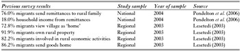
To fully understand the social, economic and environmental implications of conservation zoning, the extended reach of a PA's influence as well as the heterogeneity of human responses need to be accounted for. Here, I use Chobe National Park (NP) (Botswana) as an illustration of why there is a need to simultaneously broaden the extent and decrease the level of examination of a PA on human populations. Chobe National Park, in the northernmost part of Botswana, provides an excellent opportunity to examine both the localized, but also spatially extended effects of a PA on livelihoods. Botswana has a historically mobile population for whom migration is an adaptive strategy to minimize livelihood risk (Gwebu Reference Gwebu2004). As a result, the typical household in Botswana is scattered across different locations (such as towns, fields and cattle posts). Individuals operate semi-autonomously for certain tasks, but coordinate and coalesce for others (Kerven Reference Kerven, Hitchcock and Smith1980). Rural-urban linkages in Botswana continue to be strong, and a number of recent studies have quantitatively demonstrated the degree to which migration and remittances, the funds that migrants send back to their places of origin, influence livelihood portfolios of households that span the rural-urban spheres (Lesetedi Reference Lesetedi2003; Pendleton et al. Reference Pendleton, Crush, Campbell, Green, Simelane, Tevera and de Vletter2006) (Table 1). Notably, a counter flow from urban to rural districts suggests that population movements in Botswana continue to be to a large extent circular, as urban dwellers maintain strong links with their rural origins (Lesetedi Reference Lesetedi2003).
Results from previous surveys of rural-urban linkages in Botswana. National data drawn from households with migrants across Botswana. Regional data drawn from interviews with migrants living within the Broadhurst district of Gaborone (capital city).

Specifically, this study addresses two questions: (1) what demographic patterns characterize the way people move in and out of and within Chobe's buffer zones? and (2) what are the direct and indirect effects of Chobe's PAs on rural-urban linkages and, in turn, on urban migrants originating from Chobe? This second question requires a broadened lens that accounts for the fact that the edges of Chobe NP are linked to urban parts of Botswana in such a way that a tug on the social (or economic) fabric of one region ripples through to people and places further afield.
METHODS
The data presented were collected during nine months (2009–2010) in two villages in the Chobe Enclave, Kachikau (population 1457; CSO [Central Statistics Office] 2011) and Parakarungu (population 1002; CSO 2011), which are representative of the Northern Enclave and Southern Enclave, respectively (MacDonald Reference MacDonald1989). I conducted eight participant-observation focus group workshops that each lasted approximately three hours (grouped by older men, older women, young [defined as age 18–29] males and young females), a household survey of 90 households and 40 semi-structured interviews with village residents (stratified by age-sex classes). The focus groups and interviews with village residents focused on changes in livelihoods and settlement patterns over time, migrant behaviour, household relations, and reflections on previously collected village-level livelihood data (Appendix 1, see supplementary material at Journals.cambridge.org/ENC). While the word ‘migrant’ has several translations in the two local languages (Setswana and Sesubiya) depending on the extent of and reason for migration, ‘migrant’ in the context of the survey and interviews was understood to mean a person who had left the Chobe Enclave and primarily resides elsewhere. These village focus groups and interviews were conducted in a mix of English and Setswana, with the assistance of a translator when necessary. Questions were used as initial prompts but were open-ended. Discussion was guided by participants, following standard methodological protocol for focus group and semi-structured interviewing techniques (Perecman & Curran Reference Perecman and Curran2006). Participant-observation (sensu Guest et al. Reference Guest, Namey and Mitchell2013) was ongoing throughout the period of fieldwork. Additionally, approximately 30 interviews were conducted in English with key informants, including village tribal authorities, government officials, and relevant researchers or consultants. Secondary literature (such as government records and reports) was extensively analysed.
The household survey was administered to household heads from 31% of estimated total households (32% of Kachikau households and 30% of Parakarungu households). Households were defined as persons sharing a common residence and resources, as well as absentee family members that the interviewee considered to be part of their lolwapa (the closest Setswana translation to household). These households were selected using a random number generator from a list of plot holders in Kachikau (n = 147) and Parakarungu (n = 143) from the district Land Board (all residential plots must be registered with the Land Board, and all residents regardless of origins within Botswana are eligible to be plot holders). Government workers living in government housing (namely schools, clinics and the police station) were not included in the survey sample, as they were considered a distinct population of non-local temporary residents. The survey was translated into Setswana and Sesubiya and administered by research assistants fluent in both local languages and English. Surveys were conducted in a quiet area away from other family members and lasted approximately one hour. Male household heads were interviewed by male assistants and female household heads were interviewed by female assistants.
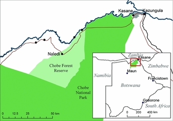
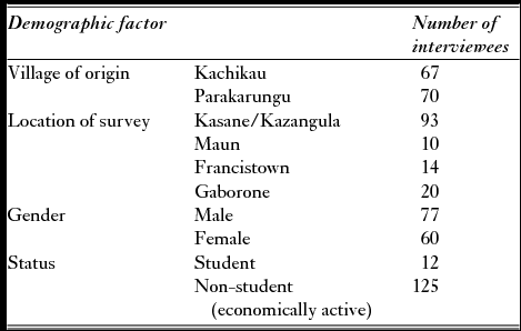
I also conducted 137 interviews with urban migrants (identified in the household study) who originated from Kachikau (n = 67) and Parakarungu (n = 70) and who were living in the urban towns of Kasane, Maun, Francistown and Gaborone (Fig. 1). In Botswana, ‘urban’ is defined as an agglomeration of 5000 or more inhabitants where 75% of the economic activity is non-agricultural (CSO 2001). Attempts were made to reach all migrants listed by Enclave family members in the survey (n = 215). We interviewed all the migrants we were able to track down and thus the group of migrants interviewed does not represent a random sampling from the original list of identified migrants. These interviews (Appendix 1, see supplementary material at Journals.cambridge.org/ENC), conducted primarily in English, were categorized and coded using the qualitative data analysis software program Atlas.ti in order to look for trends and themes in interviewee responses (Appendix 2, see supplementary material at Journals.cambridge.org/ENC).
Map of Chobe Enclave (five villages), Kasane and Kazangula, Chobe National Park and Forest Reserve. Inset is country map showing location of Chobe and key migrant destinations within Botswana.

Study site
Chobe District attracts 210 000 visitors per year (Kemmonye Reference Kemmonye2009) and generates c. US$ 37 million in tourism revenues annually (Department of Tourism 2001). Chobe NP itself generates the greatest revenue of Botswana's nine PAs (Department of Wildlife and National Parks 2000). Chobe District consists of the Kasane township (classified as an urban village and the District's headquarters; population of 9008 in 2011), three villages to the east, and the Chobe Enclave (population 4128 in 2011) to the west, the focus of this study. Chobe District includes Chobe NP (11 000 km2), six forest reserves and several wildlife management areas, together representing 80% of the District land. The five villages of Chobe Enclave are sandwiched between the Chobe Forest Reserve, Chobe National Park and the riverine border with Namibia (Fig. 1). Chobe District has the lowest population density (1 individual km−2) of any district in Botswana (Kemmonye Reference Kemmonye2009), however population density in the Enclave village settlements is estimated to be 39.1 individuals km−2.
Over the past half century, the tourism industry has played a key role in the development of the remote Chobe area. Kasane became the gateway town for tourists embarking on wildlife safaris and has a growing number of lodges, hotels and restaurants (Suich et al. Reference Suich, Busch and Barbancho2005). Since Chobe was declared a district in 2006, public administration has become the largest employer in the Chobe District (33.1% of the working population), followed by hotels and restaurants at 14.4% (Kemmonye Reference Kemmonye2009). Unemployment in Chobe district is 20.3% (national unemployment is 17.5%) (CSO 2009).
Around Chobe NP, access to natural resources (such as wildlife and forest products) and land is restricted (Gumbo Reference Gumbo2002; Mosetlhi Reference Mosetlhi2012). Villagers cannot expand communal grazing lands without encroaching on the PAs. Nor can they sell their livestock to the highly lucrative (and subsidized) European Union because regulations require beef imports to be foot-and-mouth-disease free, which make all livestock from Chobe ineligible. Further, human-wildlife conflict, especially elephant crop raiding, has increased, making crop and livestock production increasingly challenging (Jones Reference Jones2002) and causing many Chobe Enclave residents to give up farming (Gupta Reference Gupta2013). Overall, rural residents see wildlife as undermining their livelihoods and no longer providing any benefits in the way of environmental resource provisioning (such as meat, skins or other wildlife-derived products) (USAID [United States Agency for International Devleopment] 2003).
RESULTS
Protected area effects on livelihoods in adjacent villages
Residents in all focus groups reported that wildlife in and around the Park, protected by law, has become increasingly aggressive and less fearful of humans. In the village interviews, only five respondents (out of 40) answered that the Park provided any livelihood benefits, namely job creation in the tourism industry. In the household-level survey, roughly one-third (33.1%) of household members were living outside of the Enclave. Almost half of these migrants were living in or around Kasane, the safari tourism hub of the district (55.8%). The other half were living outside of the district, in the towns of Maun (8.8%), Francistown (5.6%), the capital Gaborone (12.1%) or another urban or peri-urban location (17.7%) (Fig. 1). Sixty-eight per cent of migrants were reported to have left in search of employment while 19.5% migrated for schooling. (Table 2).
Demographic information on interviewed migrants (total n = 137).

Remittances from absentee household members were providing a significant contribution to the local cash flow. The majority of the surveyed households (54.4%) reported that they received remittances from absentee household members, and these remittances (for example money, food and/or goods) contributed on average 20% to household survival (Appendix 1, household village survey question 8, see supplementary material at Journals.cambridge.org/ENC). Eighty-three per cent of households reported that they had at least one household member living and working outside the village. Over half (65.6%) of the migrants that were not at school who were interviewed (n = 125; note that boarding high school and college students are not expected to remit) stated that they regularly sent home remittances to their village households (Appendix 2, note 1 provides codes, see supplementary material at Journals.cambridge.org/ENC). The sources of income for these remittances included government employment (33.5% of migrants), tourism employment (13.8% of migrants), and informal employment (15.2% of migrants). Chobe Enclave residents relied on external sources of support not only through remittances, but also government transfers, which made up 55% of the total income from all livelihood activities in northern Botswana (BIDPA [Botswana Institute for Development Policy Analysis] 2001).
Population movements within the Chobe PA buffer
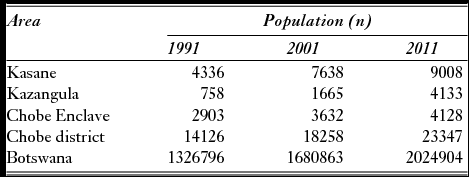
Chobe was recorded to have the highest district population annual growth rate (4.03%) for any district in Botswana between 1991 and 2001 (CSO 2001), and the third highest in-migration rate during 2000–2001, attributed to employment opportunities associated with the tourism industry (CSO 2001; Gwebu Reference Gwebu2004). The current population of the Chobe District is 23 347 (CSO 2011).
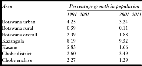
Yet the PA edges within the district are not all experiencing the same high levels of growth. The Chobe Enclave has experienced less growth than the ‘safari gateway’ town of Kasane (and increasingly the adjacent township of Kazangula). As of 2011, 39% of the Chobe District population lives in Kasane. While Kasane's population increased 75% between 1991 and 2001, the Chobe Enclave had only a 25% increase during the same period. Though the population of the Chobe Enclave is growing, there is a noticeable lack of men and women in the economically active group (defined as people aged 20–44 years old; see Kemmonye Reference Kemmonye2009; see Table 3 for annual growth rate comparisons and Table 4 for population size comparisons). In the Chobe Enclave, working-age (20–44 years old) residents comprised only 26.4% of the overall population, while in Kasane, the same age group comprised 49.7% of the population (CSO 2001). As a point of reference, this age group comprised 44.9% of the Chobe district population (CSO 2001) and 46.1% of the country (Botswana Aids Impact Survey 2002), which affirms recent governmental reports that working-age people move to ‘town’ from the Enclave to seek employment.


Qualitative data also supports the theory that working-age people are moving from the Enclave to Kasane/Kazangula. In focus groups in both villages, participants across demographic groups (men, women, elders and youth) agreed that more people were moving from the village to Kasane than in the past and that rural outmigration was a common trend. In Kachikau in particular, focus group participants of both age and sex groups stated that due to proximity to the Park, wildlife damage to cattle and crops along with limited grazing land caused people to prefer to move to town to make a living. Migrants themselves described how wildlife eating crops and/or cattle discouraged them from staying in (or returning to) their home village. Specifically in migrant interviews, there were 82 references by 73 migrants (n = 137) made to either elephant crop-raiding or wildlife threats to cattle as a reason for leaving or avoiding village agriculture (Appendix 2, note 2 provides codes, see supplementary material at Journals.cambridge.org/ENC), a pattern echoed by elders and government officials in key informant interviews. While some migrants are leaving the Chobe district entirely, the household survey indicates that the majority of these migrants (55.8%) are moving to Kasane.
Neither do all people move uniformly towards or away from a PA. There has been net population growth in the Enclave despite outmigration of job-seeking residents to Kasane and beyond. Simultaneously there has been an increase in infrastructural development and social service provisioning in the Enclave, but due to limited education, locals do not always benefit. Chobe residents held 47% of the 168 employment positions available in the clinic, schools and police station in the two study villages. The rest of the positions were filled by workers originating from other regions of the country where there is greater access to higher education and professional development. Indeed, between 2001 and 2011, Kasane's population increased by 17.9% (1.66% annual population growth rate) while the Chobe Enclave's population increased by 13.7% (1.29% annual growth rate), which represents a smaller difference in growth rates than between the 1991 and 2001 censuses. In this same period, the village adjacent to Kasane, Kazangula, has experienced a 148.2% population increase (Table 3).
Rural-urban linkages and spatially extended PA effects on livelihoods
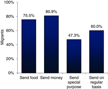
As livelihood options near the PA decline for locals, rural-urban exchanges have become increasingly unidirectional. Of migrants who left the Enclave in search of work (n = 146), 73.3% remitted either money or goods to their families. Of those who sent money (n = 89), 75.3% additionally sent another type of remittance (such as food or clothes). Roughly one-third (34.5%) of the heads of households interviewed stated that they received money or goods individually from migrant family members in addition to the remittances sent for the entire household. Eighty-four per cent of surveyed households who received cash remittances (n = 49) reported that they used these remittances to purchase food.
While migrants supported the day-to-day needs of their rural family (Fig. 2), only 27.9% of migrants were reported by their families to be investing in some long-term capacity in their home village (such as buying cattle, building a house, developing fields and/or business). Of those migrants who were reported to have invested, 45% of these individuals invested in building a house for future retirement, while only 6.7% had fields and 13.3% owned cattle. Overall, only 1.9% of migrants had arable fields and only 3.7% owned cattle.
Sending rates of those migrants who remit, as reported by rural household heads surveyed in Chobe Enclave.

In the interviews, 24.1% of migrants emphasized that agriculture was no longer a wise investment, now that elephants had made it nearly impossible to get a decent harvest, and 21.9% of migrants stated that wild buffalo from the Park precluded the opportunity to sell their cattle on the international market. As one man summarized, ‘people have left their fields because of the elephants and wild animals, buffalos and warthogs. People saw it better to work rather than plough. Working brings in money’ (personal interview, 7 May 2010). This money is then used to support rural family members’ daily expenses rather than personal agricultural holdings. One female migrant explained, ‘People they do send remittances, but they don't send so much money to buy cattle, they just send 1000 pula to buy food or clothes, they don't send 1000 to buy cattle, no. There is now something called budget, this is for water, this for electricity, this for ‘mom’ and ‘dad'’ (personal interview, 8 May 2010). Migrants from Chobe referred to the bank as a better place to store personal savings than cattle, making statements such as ‘people are not spending what they earn on the cattle, they put in the bank. Because. . .[cattle]. . . it's not a good investment. . .there are national parks that side, they [cattle] can be attacked by wild animals’ (personal interview, 24 March 2010). Interestingly, a number of migrants (35.0%) mentioned that they had chosen to invest in rental properties in town instead, and confirmed that investment in house rental instead of agriculture in Chobe was widespread.
Not only did migrants state that the village provided fewer investment opportunities, but they indicated that few migrants receive material goods from home, as they did historically. Only 6.8% of interviewed migrants reported receiving either money or agricultural goods, such as fish or produce, from their family in the Enclave. Yet migrants still continue to remit substantially, even building modern houses for their parents in the village. Migrants repeatedly expressed in interviews that integral to Batswana culture is the concept of tshwaragano (‘unity’), which refers to the idea that kin and neighbours should support each another (74 responses by 51 migrants; Appendix 2, note 3, see supplementary material at Journals.cambridge.org/ENC). In all focus groups, village residents also agreed that migrants were expected to support village family members in one form or another (Appendix 1, see supplementary material at Journals.cambridge.org/ENC). One migrant explained, ‘In town, we must not forget the people who are at home when we have something to eat, we must share because we know life that side is hard, the problem is money’ (personal interview, 10 May 2010). Migrants also remit in order to maintain a rural identity and show, as 19.7% directly mentioned, that they have not ‘forgotten where they came from’. Yet migrants despaired over the way in which low wages, high urban living costs, and steep expectations of rural kin made it difficult to survive. One female migrant explained that ‘the little that I have, I am sharing it with parents and family, so I'll be not doing anything for myself. Sometimes I can't save because when I receive 1000 pula, after rent and buying food and transport to work, then that little amount left I am sharing with other people’ (personal interview, 20 March 2010).
DISCUSSION
Wittemyer et al. (Reference Wittemyer, Elsen, Bean, Burton and Brashares2008) implied that PAs are perceived by migrants as able to provide livelihood benefits not available in other rural areas, a claim numerous scholars have contested (Igoe et al. Reference Igoe, Brockington, Randall and Scholfield2008; Shoo Reference Shoo2008; Hoffman et al. Reference Hoffman, Fay and Joppa2011; Estes et al. Reference Estes, Kuemmerle, Kushnir, Radeloff and Shugart2012). Yet the answer to the question of whether or not parks attract people because of enhanced livelihood options depends on the scale of analysis chosen. A district-level analysis of Chobe NP's buffer shows that the Chobe District population has grown rapidly, in line with the PA attractiveness thesis (Wittemyer et al. Reference Wittemyer, Elsen, Bean, Burton and Brashares2008). Yet an analysis of population and livelihoods around the Chobe PA at an extent that includes sub-district data on local villages and the nearest urban area suggests that the PA is selectively drawing some people towards and repelling others away from different areas within the buffer. These movements vary based on demographics such as age and education, and suggest that PAs may selectively attract or repel people. This level of analysis makes visible the complexity of human responses to PAs that a course-scale assessment is unable to capture.
In Chobe, the presence of the PA further restricts already marginal agricultural livelihoods, as protected wildlife raid fields and predate livestock in the Enclave. Many Chobe Enclave residents have given up farming (for extensive documentation, see Gupta Reference Gupta2013). The difficulties of small farmers in Chobe and their subsequent outmigration are undoubtedly in part a result of the multiple historical and geographical reasons for agricultural decline that has occurred in Botswana more generally over the past century. Indeed, one of the main causes of rural-urban migration in Botswana is an unremunerative and risky rural economy based on agriculture, due to low agricultural commodity prices, weak agricultural policies, land-use conversions from subsistence to commercial tenure, and periodic droughts (BIDPA 2001; Gwebu Reference Gwebu2004). Urban areas offer more opportunities for wage employment and higher incomes (Gwebu Reference Gwebu2004). Yet interviewee reports and governmental records from Chobe show that wildlife, especially elephants, has made farming even more challenging in an already ecologically and economically marginal landscape (Gupta Reference Gupta2013). Thus, although the decline of agriculture and associated outmigration is widespread within Botswana and not unique to Chobe, conservation in Chobe has reduced the role that agriculture can play as a safety net for the rural poor and as a buffer against external shocks to a rural household's livelihood portfolio (BIDPA 2001). Further, the presence of the Park has diverted labour away from farming and towards tourism (BIDPA 2001; Gumbo Reference Gumbo2002). Selective migration (rural working-age folk out and educated civil servants in) thus affects livelihoods in the Enclave by increasing reliance on remittances and/or government social safety nets, and exacerbating labour shortages for village-based activities such as agriculture. While survey results showed that 54.4% of households received remittances from absentee household members, and that these remittances contributed on average 20% to household survival, the actual percentage of households receiving remittances and the level of remittances they received are likely to be higher than the recorded level, given the tendency for under-reporting of income in rural household surveys (Devereux & Hoddinott Reference Devereux and Hoddinott1993). The fact that 73.3% of interviewed migrants reported sending remittances, also suggests that household reporting rates reflect underestimates.
While the PA hinders certain livelihood activities in the Enclave, it has spurred the creation of safari and related service industry employment opportunities in the nearby town of Kasane (CSO 2001; Kemmonye Reference Kemmonye2009), which draws many Enclave migrants, supporting the hypothesis that a PA can ‘attract’ human settlement. National and district level reports attribute employment opportunities in tourism to Kasane's population growth and the Enclave's relative decline (Chobe District Development Plan 2003; Kemmonye Reference Kemmonye2009; UNFPA [United Nations Population Fund] 2009). While there is a smaller difference in the growth rates between Kasane and Chobe Enclave from 2001–2011 than from 1991–2001, ethnographic and interview data suggest that this is likely in part because much of Kasane's growth has moved to the neighbouring township of Kazangula, not captured in this growth rate comparison (see Table 3). Qualitative data from interviews and focus groups confirms that employment opportunities in ‘town’ combined with dwindling agricultural viability in the Enclave drive working-age residents to move from the Chobe Enclave to urban areas within the district (namely Kasane) or out of the district entirely in search of work. The rise of the district-level population thus masks the movement of working-age residents from one edge of the PA (the rural villages of the Chobe Enclave) to the other edge (the urban village of Kasane), which indicates that PA buffers are not uniformly attractive. At the same time, an entirely different demographic of people, non-local educated Batswana, have moved to the Enclave to take advantage of the jobs available through the expansion of government services that has accompanied the growth in safari tourism around Chobe NP, an otherwise relatively remote part of the country. Human responses to PAs are thus not homogenous, and closer attention must be given to the question of for whom are the edges of a PA attractive or repellant, and why certain buffer areas experience different patterns of growth than others. This is important because the differential effects of PAs on people can lead to social conflict or injustices, as well as altered natural resource use.
Furthermore, the scope of a PA's influence may extend much further than is normally recognized. Migrants and non-migrants are linked through networks of obligation, normative expectations about remittances and shared understandings of kinship and friendship (Curran & Saguy Reference Curran and Saguy2001). This means that PAs can have ramifications for the social and economic fabric of both rural and urban areas, by altering the social relations and exchanges that bind rural and urban kin. In this case study, the costs of living near a park ripple through to urban migrants. Urban migrants, many of whom make relatively low wages in the context of a high cost of urban living (CSO 2003), are still expected to remit to their dependent kin (Campbell Reference Campbell2009; interview data March–July 2010). Yet migrants from Chobe Enclave do not receive the agricultural benefits (namely goods or investment opportunities) that characterized past rural-urban household transactions, as disturbance from protected wildlife makes agriculture less viable. The figures for investment patterns of Chobe migrants (27.9% investing; 1.86% had fields and 3.72% owned cattle) are also low, not only when compared with historical remittance patterns (Kerven Reference Kerven, Hitchcock and Smith1980), but also when compared with contemporary migrant behaviour in other parts of the country. Most urban migrants in Botswana retain an active or passive connection to the rural agricultural system through their families. Claims to land provide economic security when unemployed or retired. Migrants also draw direct benefits from their rural connections in the form of crops from their families’ fields, child-rearing services for their children, and a ‘bank’ to deposit accumulated capital in the form of cattle, which can be tended by the rural family members (Lesetedi Reference Lesetedi2003). For example, a 2003 study of migrant behaviour in the capital city found that 82.2% were involved in economic activities in their home village; 56.9% were involved with farming and 50.0% with livestock rearing (Lesetedi Reference Lesetedi2003). In this study, migrants were reported to maintain links to their rural kin in order to maintain access to resources, such as farmland, that could be taken advantage of in bad or uncertain times. In contrast, ethnographic data from Chobe Enclave suggests that the majority of migrants still see their rural homes as a place to eventually ‘lay their head’ (James Reference James2001) but not as a place for livelihood-oriented investment. While migrants continue to remit out of a sense of family obligation and a desire to retain a connection to their rural roots, they face significant economic pressures as they struggle to meet both their urban costs of living and rural family demands.
This suggests that conservation can affect the livelihoods of both rural and urban dwellers. Indeed, conservation may have implications for national development if investment patterns of urban workers change as a result of altered socioeconomic linkages to rural kin near parks. A scale of analysis that can encompass linkages between local, regional and national scales, as well as the rural-urban divide, will broaden conversations about the tensions and synergies between conservation and development.
The fact that the PA has qualitatively changed (rather than entirely eliminated or provided) the livelihoods of Chobe Enclave families highlights the need to shift from a debate about whether parks help or hinder rural livelihoods to one that investigates how PAs shift who lives where and how such changing demographics affect the welfare of communities and the environment. For example, remittances have been shown to provide rural households with a source of non-farm and non-wildlife-based income that, in some cases, reduces dependence on the local natural resource base and promotes biodiversity, but, in other cases, increases investment in environmentally detrimental practices (Gammage et al. Reference Gammage, Benitez and Machado2002; Naylor et al. Reference Naylor, Bonine, Ewel and Waguk2002). Empirical research on the precise mechanisms through which natural resources, biodiversity and land-use affect and are affected by remittances is sparse and variable (Lambin & Meyfroidt Reference Lambin and Meyfroidt2011), and warrants further examination. Indeed, in order to accurately assess the ecological implications of human settlement around park borders, further research must explore how different types of settlers change patterns of land and natural resource use. The outcome of increased population growth around parks is not clear without an understanding of the demographic profile of migrants and the ways in which they are using (or not using) local natural resources. Farmers and schoolteachers do not use or depend on flora and fauna in the same ways; thus population growth may not necessarily increase threats to biodiversity.
Ultimately, a park matters to peoples’ lives not only because it creates certain economic costs and benefits to the livelihoods of those who live nearby, but also because it re-structures everyday social relations; who within a family lives where, how and why intra-household exchanges are made, and what forms of control individuals have over their own lives. As the conservation and development community continues to debate the dangers and merits of biodiversity conservation for human communities, it is critical that we pay attention to these changes in the fabric of everyday life for those who live near, and in some cases far, from PAs.
ACKNOWLEDGEMENTS
This research was funded by the National Science Foundation Graduate Research Fellowship and Doctoral Dissertation Improvement Grant; the Social Science Research Council International Research Dissertation Fellowship; the Fulbright Program for US Scholars; the Rocca Fellowship for Pre-Dissertation Research; and Sara's Wish Foundation. I thank L. Fortmann, J. Brashares, two anonymous reviewers and the journal editor for their insightful and thoughtful editing of various drafts of this manuscript, as well as Mr P. Mbeha, whose field assistance was invaluable and deeply appreciated.
Supplementary material
To view supplementary material for this article, please visit Journals.cambridge.org/ENC