Unraveling complicated histories of Native peoples’ daily experiences during the rise of colonial economies holds the potential to greatly contribute to historical archaeology. In the Southeast and elsewhere, archaeologists have long considered the implications of European encounters for indigenous peoples who engaged in close relationships with colonial powers through trade or colonization (e.g., Deagan Reference Deagan1973; Larsen Reference Larsen1990; Lightfoot Reference Lightfoot and Stein2005; Reitz Reference Reitz1992; Reitz and Scarry Reference Reitz and Scarry1985; Saunders Reference Saunders and Cusick1998). Although each case is unique, prolonged involvement in colonial politics often resulted in similar types of negative outcomes for Native groups (Ethridge Reference Ethridge, Ethridge and Shuck-Hall2009). At different times and places, these encounters precipitated the spread of disease, fragmentation of kin groups, immigration of survivors, renegotiation of social and physical boundaries, and shuffling of regional political dynamics (Jordan Reference Jordan2013; Voss Reference Voss2005, Reference Voss2008; Warrick Reference Warrick2003).
In Southeastern North America, the devastation wrought by European contact in one locale often reverberated outward by scattering refugees across the landscape, leading to the formation of new coalescent, or multiethnic, villages (Ethridge Reference Ethridge, Pluckhahn and Ethridge2006, Reference Ethridge, Ethridge and Shuck-Hall2009; Kowalewski Reference Kowalewski, Pluckhahn and Ethridge2006). Colonial involvement thus set in motion significant demographic, social, and political changes that had far-reaching consequences for both European and indigenous peoples (Jennings Reference Jennings, Ethridge and Shuck-Hall2009; Marcoux Reference Marcoux2010; Meyers Reference Meyers, Ethridge and Shuck-Hall2009; Waselkov Reference Waselkov1989). These changes cultivated an uncertain landscape in which neither groups that pursued explicit and continued trading relationships with European powers nor those who were less involved were entirely untouched by the chaos that unfolded.
Ethridge (Reference Ethridge, Pluckhahn and Ethridge2006, Reference Ethridge, Ethridge and Shuck-Hall2009) coined the phrase “shatter zone” to characterize the devastating and wide-reaching effects of the restructuring of Southeastern Native societies following the introduction of a commodity-focused economy driven by English colonial demands. Although Native groups that formed long-term exchange relationships with European powers reconfigured their social organization and political economies in significant ways, groups that were less involved in colonial politics often faced even greater devastation as they became the victims of well-armed militaristic Native slaving societies that emerged as early as AD 1650 (see Ethridge Reference Ethridge, Pluckhahn and Ethridge2006, Reference Ethridge, Ethridge and Shuck-Hall2009). Slave raiding proved to be an especially pervasive means through which Native peoples located far from colonial territories were drawn into the chaotic social climate of the seventeenth-century Southeast (Ethridge Reference Ethridge2010:98; Gallay Reference Gallay2002:154).
Less understood is how certain indigenous peoples who lacked a prominent role in delivering goods and slaves to colonial traders experienced the colonial period (AD 1670–1783). What consequences did slave raiding have for the villages of the victims? How did these villages cope with the threat and consequences of losing kin? Ethnohistoric accounts indicate that mid-seventeenth-century indigenous inhabitants of the Eno River valley in the North Carolina Piedmont frequently fell victim to attacks by Native slave raiders, who abducted countless women and children from their villages. However, the extant archaeological evidence suggests that the daily practices of Native peoples of this river valley did not significantly change from the last two centuries of the Late Woodland period (AD 800–1600) to 1680 (Ward and Davis Reference Ward, Stephen Davis, Browse, Cowan and Mainfort2001:132). I reconcile these two ostensibly contradictory narratives through analysis of plant foodways and architecture; this effort reveals that, by the mid-seventeenth century, local indigenous peoples had reconfigured their daily lives in ways that would have proved advantageous to coping with threats of captive taking. I suggest that these changes occurred in the context of a village (Jenrette) that was regularly dealing with the threat of its women and children being stolen by warriors from several militaristic slave-raiding societies. My architectural analysis indicates that Jenrette residents physically resided at the site for no more than two decades. Significantly, findings generated by this study complicate previous interpretations of seventeenth-century indigenous foodways in this region and suggest that slave raiding had a profound impact on the daily lives of Eno River valley residents.
Foodways, Risk, and Uncertainty
Foodways refer to the practices by which people propagate, cultivate, harvest, prepare, consume, and dispose of food (Welch and Scarry Reference Welch and Scarry1995). As a cultural construct, foodways can be highly conservative and slow to change (Scarry and Reitz Reference Scarry and Reitz2005:118; Simoons Reference Simoons1994). Yet at times foodways are modified quickly in response to emerging social, political, environmental, or other circumstances (Mrozowski Reference Mrozowski, Hall and Silliman2006:29–31; Nunn and Qian Reference Nunn and Qian2010:167–177; O'Shea Reference O'Shea, Halstead and O'Shea1989). Recent research on alternate or atypical foodways focuses on situations of plenty, such as those involving commensal politics (e.g., Haggis Reference Haggis2007; Kassabaum Reference Kassabaum2014; Pauketat et al. Reference Pauketat, Kelly, Fritz, Lopinot, Elias and Hargrave2002; Steele Reference Steele2004; VanDerwarker, Scarry, and Eastman Reference VanDerwarker, Scarry, Eastman and Twiss2007). However, risk and/or uncertainty can also impact food preferences, sharing practices, and collection/production strategies (Larson, Johnson, and Michaelsen Reference Larson, Johnson and Michaelsen1994; Marston Reference Marston2011; VanDerwarker, Marcoux, and Hollenbach Reference VanDerwarker, Marcoux and Hollenbach2013; Winterhalder Reference Winterhalder1986).
Risk describes circumstances in which possible outcomes can be identified and evaluated by affected individuals, while uncertainty defines situations involving factors whose impacts cannot be predicted (Keynes Reference Keynes1921; Knight Reference Knight1921; Luce and Raiffa Reference Luce and Raiffa1957; Stirling Reference Stirling, Berkhout, Leach and Scoones2003:43–44; Winterhalder, Lu, and Tucker Reference Winterhalder, Lu and Tucker1999). Circumstances of risk or uncertainty can be created by a variety of factors, such as environmental conditions (e.g., climate, soil fertility), natural disasters, sociopolitical changes (e.g., culture contact, state formation), warfare, or economic deprivation (Carter Reference Carter1997; Dillehay and Kolata Reference Dillehay and Kolata2004; Kennett and Marwan Reference Kennett and Marwan2015; VanDerwarker and Wilson Reference VanDerwarker, Wilson, VanDerwarker and Wilson2016). Each factor can limit the range of available food choices, how foods can be grown, and when foods can be harvested (see Logan Reference Logan2016a; Marston Reference Marston2011). In this way, the study of past foodways can reveal unique insights into the ways in which risk and uncertainty impacted the lifeways, nutritional status, and opportunities of both hunter-gatherers (e.g., Winterhalder Reference Winterhalder and Cashdan1990) and agriculturalists (e.g., Cancian Reference Cancian and Bartlett1980; Hardaker et al. Reference Hardaker, Lien, Anderson and Huirne2015).
Food security is a continuum used to measure access to food, an aspect of daily life that can be directly impacted during periods of stress (Logan Reference Logan and Hegmon2016b). Although modern definitions of food security are rooted in the ability to meet minimum dietary requirements (see Food and Agricultural Organization of the United Nations 2003; Godfray et al. Reference Godfray, John, Beddington, Crude, Haddad, Lawrence, Muir, Pretty, Robinson, Thomas and Toulmin2010), food security can be more broadly understood as the ability to (1) obtain a satisfactory amount of food in the present and (2) access adequate food in the immediate future (Logan Reference Logan and Hegmon2016b:107). Some causes of food insecurity are directly related to environmental conditions, while others are entirely social and anthropogenic. Research conducted by VanDerwarker and Wilson (Reference VanDerwarker, Wilson, VanDerwarker and Wilson2016) provides an archaeological example of how social factors may contribute to food insecurity. In the Mississippian central Illinois River valley, conditions of endemic violence made exploiting wild foods and riverine resources that were located outside of palisade walls a dangerous practice. Consequently, these social conditions limited the diversity and nutritional quality of available food choices and introduced limitations on food security. When food security is compromised, people must make choices. In agricultural societies, two common cross-cultural strategies for responding to risk or uncertainty are field scattering and future discounting.
Field scattering, also sometimes referred to as land or field fragmentation (see Bentley Reference Bentley1987), is a process of agricultural extensification in which the total cultivated land consists of infields located within or near the settlement and dispersed outfields located at variable distances from the settlement (Halsted and O'Shea Reference Halsted and O'Shea1989). These fields can vary in size and do not necessarily feature the same cultigen(s). Ethnohistoric and archaeological case studies have revealed widespread evidence for the practice of field scattering strategies among peasants in Europe (McCloskey Reference McCloskey1976, Reference McCloskey1991) and Peru (Goland Reference Goland1993), ancient and modern agriculturalists in Mesoamerica (Killion Reference Killion1990, Reference Killion and Killion1992; VanDerwarker Reference VanDerwarker2005), and indigenous Mississippian and colonial-period farmers in Southeastern North America (Waselkov Reference Waselkov and Gremillion1997).
Field scattering strategies can yield several advantages. Significantly, a field scattering approach can reduce the amount of time that is spent in field locations. In temperate climates where rainfed agriculture is possible, slash-and-burn farmers need only be physically present for four events, several of which can be conducted simultaneously: land clearance, soil preparation, planting, and harvest. The cultivation of numerous small fields as opposed to one or a few large fields can also reduce labor demands for any single harvest. Mid-1960s viticulturalists residing on the island of Pantelleria, for example, elected to plant small, spatially segregated fields and stagger harvest times (i.e., serial harvesting) to prevent the need for extrahousehold labor, particularly in the event of a very productive and/or wet year (in which grapes must be quickly taken to market; Galt Reference Galt1976:102). The widespread adoption of serial harvesting also facilitated greater labor availability in the event of an unexpected boom; by staggering planting times, households whose crops were still ripening could help others whose crops were ready to harvest. Finally, field scattering can combat location-specific problems such as raiding, flooding, pests, and poor soil fertility. By spatially distributing risk across the landscape, field scattering allows for crop loss in certain fields given the expectation that fields located elsewhere may not encounter the same challenges (see Goland Reference Goland1993; McCloskey Reference McCloskey1976, Reference McCloskey1991). In this way, field scattering can serve as an effective tool for coping with ecological or social problems.
People facing potential subsistence stress may also discount the future, increasing their reliance on foods whose yields are more dependable in that they are less likely to be compromised by environmental variability. When given a choice between immediate returns (i.e., foraged resources) and delayed returns (i.e., agricultural resources), decision-makers often discount foods with delayed returns because they introduce more opportunities for catastrophic loss (Tucker Reference Tucker, Kennett and Winterhalder2006:24; VanDerwarker, Marcoux, and Hollenbach Reference VanDerwarker, Marcoux and Hollenbach2013:72). Investing in foraged resources, therefore, provides a short-term solution to problems of food security, especially in situations for which long-term planning is difficult. Rather than using quantitative indices to assess the likelihood of participation in future discounting strategies, I present future discounting as a set of practices that are favorable when faced with uncertain circumstances but that are also situationally contingent in their execution.
Late Woodland and Early Colonial-Period Life in the North Carolina Piedmont
Keeping issues of field scattering and future discounting in mind, I shift my focus to the North Carolina Piedmont, summarizing major social and political changes that occurred from the Late Woodland period to the seventeenth century. I argue that the mid-seventeenth century was a critical turning point for indigenous peoples of the North Carolina Piedmont (sensu Beck Reference Beck2013). Around this time, English traders and indigenous slavers began conducting business in the region, activities that I and others (see Beck Reference Beck2013; Ethridge Reference Ethridge2010; Meyers Reference Meyers, Ethridge and Shuck-Hall2009) argue ultimately resulted in the introduction of a new mode of commodity exchange and the widespread destabilization of indigenous polities. To properly assess the gravity of these developments it is necessary to conceptualize major changes to the social climate of the North Carolina Piedmont that occurred in the preceding years.
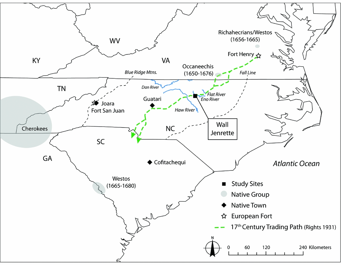
The North Carolina Piedmont constitutes the state's central portion, between the Blue Ridge Mountains to the west and the Fall Line to the east, beyond which is the low-lying Coastal Plain (Figure 1). At the time of the first European arrivals, this region was home to both Late Woodland and South Appalachian Mississippian groups. Inhabiting the northern area of the Piedmont, Late Woodland peoples erected politically autonomous palisaded villages and practiced relatively egalitarian social relations; mortuary evidence suggests that gender and age were important axes of identity that differentially impacted burial treatment (Beck Reference Beck2013:47–48; Eastman Reference Eastman, Eastman and Rodning2001). In contrast, South Appalachian Mississippians, located in the central and southern portions of the Piedmont, negotiated hierarchical social relationships, constructed earthen mounds on which they held feasting events performed for large audiences, and created regional, multicommunity polities (i.e., chiefdoms) with political centers that exercised control over surrounding villages (Beck Reference Beck2013:30, 33; Boudreaux Reference Boudreaux2007; Ward and Davis Reference Ward and Stephen Davis1999:119).
Approximate locations of study sites, Native towns/groups, and assorted landmarks mentioned in the text.

Archaeological investigations in the northern Piedmont reveal evidence of dynamic changes in settlement organization during the Late Woodland period (AD 800–1600). In the first half of this period, inhabitants began to aggregate, founding hamlets along the Eno, Dan, Flat, and Haw Rivers (Davis and Ward Reference Davis and Ward1991). These river valleys continued to serve as favored settlement locations until well into the colonial period (Lefler Reference Lefler and Lawson1967; Ward and Davis Reference Ward and Stephen Davis1999:103). Residents further expanded their settlements and began erecting palisades as early as AD 1400 (Davis and Ward Reference Davis and Ward1991:43). Within these nucleated villages, Native peoples organized themselves into egalitarian societies, practiced mixed foraging-farming subsistence strategies, and exploited the abundant terrestrial and aquatic animal resources that surrounded them (Ward and Davis Reference Ward and Stephen Davis1999:78–79).
Favorable ecological conditions, however, did not necessarily lead to long-term occupation elsewhere in the region. In the southwestern Piedmont, a major demographic shift occurred from 1400 to 1450 that involved the abandonment of settlements along the Broad, Great Pee Dee, and Savannah Rivers (Beck Reference Beck2013:57). Subsequently, the Mulberry site (plausibly the village of Cofitachequi in the Hernando de Soto expedition chronicles) emerged as a major political center whose power likely had a dampening effect on the development and growth of other Piedmont chiefdoms throughout its tenure (AD 1450–1540; Beck Reference Beck2013).
Spanish explorers entered the Piedmont by the mid-sixteenth century. Expeditions led by Hernando de Soto (1539–1543) and Juan Pardo (1566–1567) visited numerous towns in the Carolina Piedmont and western Tennessee (Beck Reference Beck2013:4). Spanish entradas into the North Carolina Piedmont had far-reaching impacts. Indeed, according to the account of Pardo's notary Juan de la Bandera, at least 13 orata (town or village headmen) representing groups from across the North Carolina and South Carolina Piedmont came to the town of Canos (or Cofitachequi), located along the Wateree River in present-day South Carolina, to await the arrival of Juan Pardo and his entourage (Beck Reference Beck2013:79, 82). Bandera also mentions that Native leaders traveled as many as 18 days to visit Pardo when he was staying at the indigenous village of Joara and that leaders from towns within a few days’ travel regularly visited the settlement (Hudson Reference Hudson2005:88–89; Rudes Reference Rudes2004:360–363).
Spanish involvement in the Carolina Piedmont was manifested not only in contacts, or brief encounters (sensu Silliman Reference Silliman2005), but also in endeavors of colonialism that generated a prolonged social dialogue between indigenous residents and their new neighbors. Fort San Juan, located on the upper reaches of the Catawba and Yadkin Rivers in the western Piedmont and the remains of which have been identified archaeologically at the Berry site, is the earliest European settlement in the interior of the present-day United States. Archaeological investigations at the Berry site, focused on exploring interactions between the residents of the fort and the adjoining indigenous town of Joara, have revealed that soldiers were ultimately indebted to their indigenous hosts, who provided food and ensured their security (see chapters in Beck, Rodning, and Moore Reference Beck, Rodning and Moore2016).
However, by the late seventeenth century, indigenous peoples had abandoned many of the previously powerful and densely populated indigenous settlements recorded by Spanish explorers (Beck Reference Beck2013:135). The area surrounding the town of Guatari provides a striking example. When Pardo visited the town in 1567, his notary recorded at least 39 chiefs who were subordinate to the Guatari chief and 18 towns in Guatari's immediate vicinity. But by 1670, when a German physician named John Lederer visited the area, apparently no towns were nearby (Beck Reference Beck2013:123–124; Hudson Reference Hudson2005:Figure 6, 91). From 1650 to 1675, the social landscape of the Piedmont was fundamentally rearranged as the shattering of villages and polities led inhabitants to seek refuge among other groups (Beck Reference Beck, Ethridge and Shuck-Hall2009). During this period, the region also became a more dangerous place, as contemporary ethnohistoric records provide many accounts of violence among indigenous groups and between indigenous peoples and English colonists.
Two major events that occurred to the north during the latter half of the seventeenth century set processes in motion that ultimately led traders and slavers to lay waste to the Piedmont. The first was the establishment of Fort Henry in 1645 near modern-day Petersburg, Virginia. Representing an important physical and ideological border, Fort Henry was the only location at which Virginia colonists could legally trade with tributary and nontributary Indians and the only legal access point for (1) indigenous peoples seeking to travel west to Anglo-Virginia and (2) colonists seeking to travel east to Native-occupied lands (Shefveland Reference Shefveland2016:22–23). Significantly, Fort Henry also offered Virginia traders unprecedented access to the Carolina Piedmont, into which they quickly expanded; by 1659, Virginians had formed commercial networks that extended as far south as the Savannah River (Kelton Reference Kelton2007:101).
Brutality and uncertainty befell both colonists and Native peoples who entered the Piedmont. Abraham Wood, Fort Henry's long-standing director, financed and organized numerous expeditions into the Carolina Piedmont to gain access to Indian products, skins, and slaves (Shefveland Reference Shefveland2016:23). In both April and May 1673, Wood sent his apprentice, Gabriel Arthur, and an experienced trader, James Needham, south to explore possibilities for breaking the monopoly that the Occaneechis, an armed Native group that at the time was located on an island in the Roanoke River, exercised over Piedmont trade (Beck Reference Beck2013:145; Kelton Reference Kelton2007:115). According to Wood's account of these expeditions, recorded in a letter to John Richards dated August 22, 1674, Needham and Arthur were initially turned back in April by the “Indians before the mountaines” (Wood Reference Wood, Alvord and Bidgood1912:211) but set out again in May. During the second trip, they found 50 Tomahitans (area of origin unknown, but they may have lived alongside the Cherokees; Beck Reference Beck2013:132) who were looking to meet with the Occaneechis. They negotiated a deal that if the Englishmen would stay behind with most of the Tomahitans at Occaneechi Island, a small contingent would return to Fort Henry. When the messenger designated to communicate the arrival of this envoy was delayed by bad weather, the remaining Tomahitans “through ye instigation of ye Occhonechees” (Wood Reference Wood, Alvord and Bidgood1912:211) assumed that negotiations at the fort had gone badly and returned home with Needham and Arthur as their captives. Later in the journey, following the emissaries’ safe return, the group was passing through the town of Yattkin, presumably located along the Yadkin River in the central Piedmont (Beck Reference Beck2013:133), when Hasecoll, an Occaneechi Indian who had joined the envoy, and Needham engaged in a violent altercation, resulting in Hasecoll shooting Needham in the head (Wood Reference Wood, Alvord and Bidgood1912:217). While the Tomahitans were mourning the potential loss of their budding trading relationship with the English, Hasecoll cut out Needham's heart, held it in his hand while looking toward English plantations in the east, and stated that “hee valued not all ye English” (Wood Reference Wood, Alvord and Bidgood1912:217). In these excerpts, Wood's account reveals the volatile and dangerous social climate of the Piedmont, which was exacerbated by the need to establish and monopolize trading relationships and goods extraction (animal skins and slaves) in this untried territory.
The second major event to occur in this region during the mid-seventeenth century was the 1656 arrival of a well-known militaristic slaving society, the Westos, at the James River (about 240 km north of the Eno River valley; Bowne Reference Bowne2005:73; Meyers Reference Meyers, Ethridge and Shuck-Hall2009:81). Shortly after arriving, they began conducting expeditions southward to capture slaves to sell to Virginians; gaining access proved to be so successful that the Westos were raiding villages of present-day Georgia and Florida by 1659 (Ethridge Reference Ethridge2010:98; Meyers Reference Meyers, Ethridge and Shuck-Hall2009:96). Scholars have deduced that the Westos migrated to Virginia from somewhere to the northeast, though their exact place of origin and ethnic background are debated (see Meyers Reference Meyers, Ethridge and Shuck-Hall2009). The Westos likely represented a displaced faction of the Eries (a coalescent group who lived to the west of the Five Nations Iroquois) known as the Richahecrians (see Bowne Reference Bowne2005; Meyers Reference Meyers, Ethridge and Shuck-Hall2009:83). Well armed by their colonial partners, the Westos and the Occaneechis were infamous for their dominance as slave raiders and were directly responsible for the decimation and demographic decline of the North Carolina Piedmont from 1650 to 1675 (Beck Reference Beck2013:135). By the late 1670s, the Iroquois contributed to this effort by igniting a mourning war that sent warriors south into Virginia and the Carolinas to acquire captives to replace kin lost in recent epidemics (Ethridge Reference Ethridge2010:98).
Written accounts of travels through the Piedmont provide compelling testament that the Westos, and by extension other slave-raiding/captive-taking groups, posed a grave and formidable threat to local inhabitants. After visiting the town of Ushery in 1670, John Lederer recalled his conversations with its residents, one of which he refers to as the Prince:
This Prince, though his Dominions are large and populous, is in continual fear of the Oustack-Indians seated on the opposite side of the Lake; a people so addicted to Arms . . . they are a cruel generation, and prey upon people, whom they either steal, or force away from the Usheryes in Periago's, to sacrifice to their Idols [Cumming Reference Cumming1958:30; emphasis in original].
Beck (Reference Beck2013:130) argues that the Oustack Indians described in Lederer's account are the Westos, drawing a compelling connection between the human sacrifice practices recorded in Lederer's account and claims that the Westos practiced cannibalism. If this association is valid, then Lederer's account provides direct evidence that the Piedmont was an active target of slave raiding by 1670, though the fact that the Westos would have had to pass through the Carolina Piedmont on their way to Georgia and Florida suggests that these attacks may have occurred as early as 1659.
Slave raiding had various interconnected consequences for Native villages. The most assured consequence was a decrease in population, especially with regards to children, adolescents, and women of reproductive age (Beck Reference Beck2013:153; Kelton Reference Kelton2007:103–104; Rice Reference Rice2009:136; Shefveland Reference Shefveland2016:35). Children were particularly desirable, as they were viewed as useful and manageable additions to colonial households, as opposed to adults, who proved much more difficult to control (Shefveland Reference Shefveland2016:35). Slave raiders also carried away food that was vital to the village's survival. In a letter dated September 12, 1670, Stephen Bull writes to Lord Ashley, one of the lords proprietors of Carolina: “Westoes . . . doe come vpon these Indians here in the tyme of their cropp & destroye all by killing Caryinge awaye their Corne & Children & eat them” (Bull Reference Bull2000:194). Beyond immediate losses, the removal of women and children, who supplied much of the agricultural labor in indigenous communities, subsequently resulted in short- and long-term food insecurity. Kelton paints a graphic picture of how this series of events played out:
The intense violence associated with slave raids forced numerous indigenous peoples to go hungry . . . Thousands of Natives huddled in fortified, compact, and unsanitary towns, where the fear of being captured kept them from going out to hunt game or harvest crops [2007:102].
Finally, the synchronous removal of indigenous women and children and the rewarding of male warriors (by colonial traders) for acquiring slaves and goods resulted in the devaluation of Native women's contributions; these changes reflected a critical shift in the relative power of men and women to influence indigenous political economies (Beck Reference Beck2013:159).
In sum, ethnohistoric evidence paints a clear picture of the North Carolina Piedmont as hostile, destabilized, and rapidly depopulated during the latter half of the seventeenth century. Raiding activities played out on a much grander stage, which saw the Piedmont become a new target for exploitation. However, archaeological investigations in the Eno River valley have yet to provide a record of major changes in Native lifeways prior to the last two decades of the seventeenth century.
The Eno River Valley Paradox
Archaeological investigations in the Eno River valley have revealed evidence that suggests seventeenth-century European-Native interactions were intermittent and did not significantly impact Native lifeways. European trade goods first appeared in the North Carolina Piedmont during the Mitchum (AD 1600–1670), Middle Saratown (AD 1620–1670), and Jenrette (AD 1650–1680) phases (Ward and Davis Reference Ward, Stephen Davis, Browse, Cowan and Mainfort2001), and many of the artifacts found on sites dating to these periods consist of locally produced Native American goods rather than newly available European counterparts (Ward and Davis Reference Ward and Stephen Davis1999:255). Davis (Reference Davis, Ethridge and Hudson2002:152) interprets this paucity of European artifacts as indicative of indigenous peoples receiving these objects from Native middlemen and notes that they did not wholly replace their indigenous equivalents after being adopted.
Researchers have also used other lines of archaeological evidence to suggest continuity in lifeways from the Late Woodland period to the end of the seventeenth century. Based on an analysis of archaeobotanical data for sites in the Eno River valley, Gremillion (Reference Gremillion, Ward and Davis1993a) argued for the continued performance of traditional foodways throughout the seventeenth century. Furthermore, mortuary analysis of the Jenrette site (AD 1650–1680) burial assemblage revealed no evidence of a significant increase in mortality or physiological signs of epidemic disease (Ward and Davis Reference Ward, Stephen Davis, Browse, Cowan and Mainfort2001:132). It is not until the occupation of the eighteenth-century Fredricks site (ca. AD 1700–1710), a town established by the Occaneechis following their arrival in the region, that we see the first significant signs of sustained European interaction and its devastating effects on the Eno River valley, including evidence of rapid population loss, the appearance of firearms, and widespread distribution of other European artifacts, which are more abundant in comparison to earlier sites (Ward and Davis Reference Ward and Stephen Davis1991, Reference Ward, Stephen Davis, Browse, Cowan and Mainfort2001:132).
Clearly, ethnohistoric evidence of intensive slave raiding in the Piedmont starkly contrasts with archaeological interpretations of the Eno River valley as an area that was insulated from the devastating effects set in motion by the rise of a commodity-driven, exploitative, and pervasive colonial market economy. A diachronic examination of plant foodways, which provide a record of routine practices that would have been acutely affected by slave raiding, with attention to possible indicators of uncertainty offers an opportunity to reconstruct daily life and reconcile these two divergent narratives. I argue that, despite archaeological evidence for low quantities of European trade goods and typical mortality rates, indigenous inhabitants of the Eno River valley do appear to have coped with uncertainty in a manner that correlates well with the hostile social conditions created by the movement of indigenous slave raiders into the Piedmont and, by extension, the escalating demands of the commodity-driven colonial Atlantic economy.
The Datasets: Methods, Analyses, and Results
To assess issues of food insecurity in the context of uncertainty, I adopt a diachronic approach, integrating data from two sites: Wall (AD 1400–1600) and Jenrette (AD 1650–1680). Excavated by the Research Laboratories of Archaeology at the University of North Carolina at Chapel Hill between 1983 and 2016, both sites were circular palisaded villages located approximately 150 m apart on the western bank of the Eno River (see Figure 1). I provide an updated comparison of botanical remains from both sites, integrating new data from 14 additional features. Next, I consider architectural data from Jenrette to evaluate occupational duration. Finally, I consider the implications of my results for understanding seventeenth-century indigenous lifeways in the Eno River valley.
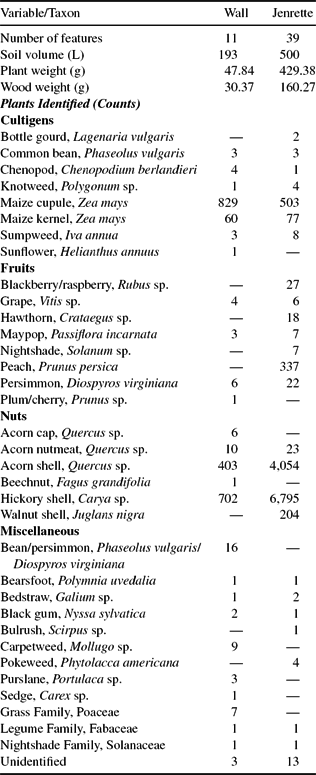
I consider plant remains from flotation samples deriving from 50 features, 11 from Wall and 39 from Jenrette (Table 1). All 50 features represent pits containing secondary refuse. Of these features, I sorted and analyzed botanical remains from eight features from Wall and six from Jenrette (Melton Reference Melton2014). Flotation samples from all remaining features were analyzed and published by Kristen Gremillion (Reference Gremillion1989, Reference Gremillion, Ward and Davis1993a). Analytical methods for both sets of samples were identical, and the only notable difference was in how data are reported. Since Gremillion recorded only weights for maize, nuts, peach, and bottle gourd rind, I estimate counts from these weights based on standard archaeobotanical methods (e.g., VanDerwarker, Scarry, and Eastman Reference VanDerwarker, Scarry, Eastman and Twiss2007). Subsequent quantitative analysis employs density measures, which standardize counts by soil volume.
Counts of Plant Taxa Identified in Wall and Jenrette Flotation Samples.

Botanical Remains
I examine the representation of different plant groups in each assemblage and consider evidence of future discounting by evaluating the density of botanical remains for plants requiring different levels of labor investment. I define two basic categories of resources: foraged (i.e., nuts and fruits) and agricultural (i.e., maize). A comparison of maize and foraged food densities for each site revealed an apparent seventeenth-century shift in food preferences involving increasing dependence on wild foods relative to maize (Figure 2). This pattern suggests that Jenrette inhabitants intensified their exploitation of resources with immediate returns beyond earlier Late Woodland levels. Specifically, the densities of both nuts and fruits are higher in the seventeenth century than in the preceding Late Woodland period (Figure 3). This trend persists even when peach, a European cultigen introduced during the seventeenth century (see Gremillion Reference Gremillion1993b), is excluded from the analysis (see Figure 3).
Bar chart depicting densities of maize and foraged foods (counts/L).

Bar chart depicting densities of maize, fruits, and nuts (counts/L).

It is also important to consider the increase in dependence on wild foods with respect to seasonality, as it is possible that Jenrette inhabitants only exploited wild resources that ripened before or after maize harvests. Seasonality analysis of fruit and nut taxa identified in the Jenrette assemblage indicates that the wild resources that were collected could have been procured before, during, and after maize harvests (Figure 4). Therefore, it appears that Jenrette residents not only used wild resources to supplement poor maize harvests but may have also procured wild resources in preparation for the possible loss of maize yields.
Season of harvest for fruit and nut taxa identified at Jenrette (seasonality data derived from Peterson Reference Peterson1977; Scarry Reference Scarry and Minnis2003; VanDerwarker, Scarry, and Eastman Reference VanDerwarker, Scarry, Eastman and Twiss2007).

Box plots reveal that maize densities are consistently lower for features in the subsequent Jenrette site assemblage, and this difference is statistically significant, as noted by the nonoverlapping notches that give the box plots their hourglass shape and which represent 95% confidence intervals (Figure 5). I examined this pattern more closely by evaluating densities of maize kernels and cupules separately. Maize kernels represent the edible portion of the plant and are discarded as a result of cooking accidents or spoilage; in contrast, maize cupules, inedible sockets that hold kernels and form the cob, represent the by-products of shelling and are discarded during processing. Figure 6 clearly demonstrates that a decrease in maize cupules, not kernels, is responsible for the overall decrease in maize density.
Box plots of maize densities (counts/L).

Box plots of (a) maize cupule and (b) maize kernel densities (counts/L).

These findings have several important implications for understanding maize investment by Jenrette site residents. The decline in maize cupule density at Jenrette reveals that residents processed less maize at the site than earlier occupants of the adjacent Wall site. A decrease in on-site maize processing debris does not necessarily suggest that Jenrette residents consumed less maize than Wall site residents; in fact, continuity in maize kernel distributions between the two sites directly counters this proposition (see Figure 6). Instead, it appears that yields did not decline but that the location of at least some shelling moved off-site, leaving less cupule and cob debris within the settlement. Off-site processing is characteristic of outfield production strategies, as shelling significantly reduces the transport costs associated with harvesting outfields (VanDerwarker Reference VanDerwarker2006; see also Killion Reference Killion1990). By scattering maize fields across the landscape, Jenrette residents would have effectively reduced their susceptibility to crop loss from location-specific threats.
Collectively, these patterns provide evidence that Jenrette site residents adopted risk-averse subsistence strategies. Jenrette residents increased their reliance on foraged resources, which offered immediate returns. They continued to farm maize but introduced field scattering in an effort to spatially distribute risk, thereby safeguarding some of their yields. These data suggest that Jenrette inhabitants adopted alternate foodways that have been commonly linked to circumstances of uncertainty.
Architectural Evidence
Like foodways, architectural analysis of anticipated and actual site occupation spans has the potential to reveal evidence of uncertainty. Anticipated site occupation span refers to the duration that inhabitants intend to occupy a site, while actual occupation refers to the length of time that a site was occupied (see Kent Reference Kent1992). In conducting my analysis, I reconsider previously collected data for the Jenrette site (see Ward and Davis Reference Ward and Stephen Davis1993), specifically evidence of rebuilding, with attention to questions of perceived uncertainty.
Evidence for a social landscape of uncertainty and the impairment of long-term planning may be revealed not only through foodways but also through settlement occupation spans. The results of Adler's (Reference Adler1996) cross-cultural study indicate that the practice of low-investment agricultural strategies (e.g., risk-reducing methods such as field scattering) is explicitly linked to greater residential mobility. Indeed, while one would expect external threats (particularly circumstances of endemic violence) to result in greater preparations for long-term settlement occupations as people hunker down behind palisade walls for protection, the perception of an uncertain future by people not plagued by warfare may have had the opposite effect, involving less investment in site revitalization as relocation becomes a more promising option for ameliorating local problems. If Jenrette residents experienced uncertainty, one probable outcome would be a brief village occupation with minimal evidence for the rebuilding of houses and palisade walls; low investment in house construction has been documented archaeologically among seventeenth- and eighteenth-century Cherokees who endured volatile social conditions (Marcoux Reference Marcoux2010:134).
Architectural evidence from Jenrette indicates that the village was inhabited only briefly. While houses at the earlier Wall site were modified and rebuilt up to five times over the course of the site's occupation (Petherick Reference Petherick, Dickens, Ward and Davis1987:47), none of the four houses excavated at Jenrette demonstrate any evidence for rebuilding or superpositioning (Figure 7; Ward and Davis Reference Ward and Stephen Davis1993:383). Various studies (Blew and Kulp Reference Blew and Kulp1964; Marcoux Reference Marcoux2010:120–123; Pauketat Reference Pauketat2003:46) suggest that when exposed to the temperate conditions of the Southeast, embedded posts of wood commonly used in house construction last from less than one to 18.7 years before deteriorating, though rate of decomposition varies by wood species. Based on these estimates, houses at Jenrette appear to have been occupied briefly, perhaps for only 20 years at most. Furthermore, the overall density of domestic debris is much lower for the Jenrette site than for the earlier Wall site. Whereas a thick trash midden was discovered near the Wall site palisades, midden deposits were not encountered during Jenrette site excavations (Ward and Davis Reference Ward and Stephen Davis1993:383).
House 3 at subsoil from the Jenrette site. The house measured 4.89 × 6.70 m. Courtesy of the Research Laboratories of Archaeology, University of North Carolina, Chapel Hill.

Additional lines of evidence support a brief occupational duration. Jenrette residents produced less extensive fortifications in comparison to their Late Woodland predecessors. Five concentric palisades protected Wall site residents (though not necessarily all at once), while only a single ring of posts surrounded Jenrette; there is no definitive evidence of warfare-related skeletal trauma from either site (Reinberger Reference Reinberger2014; Wilson Reference Wilson, Dickens, Ward and Stephen Davis1987). In sum, architectural evidence from Jenrette suggests that occupants did not live there for an extended period. When viewed in combination, evidence for increasingly risk-averse foodways and decreasing attention to house and palisade repair suggest that Jenrette inhabitants took measures to ensure short-term stability rather than long-term security.
Discussion
Archaeological evidence for a brief settlement occupation span and the practice of risk-averse foodways at Jenrette correlates well with ethnohistoric evidence of slave raiding and poses interesting questions for interpreting indigenous lifeways in the Eno River valley from AD 1650 to 1680. The ethnohistoric accounts of fear and violence presented here provide compelling evidence that slave raiding was a chronic and pervasive problem in the Eno River valley. At Jenrette, the adoption of future discounting and field scattering practices fits expectations for perceived uncertainty.
There are several reasons why future discounting would have served as a particularly beneficial strategy for potential victims of slave raiding. Under conditions in which agricultural yields were at risk of being stolen by slavers, summer and fall surpluses of fruits and nuts (bookending and overlapping July-September maize harvests) would have supplemented agricultural yields in years of significant crop theft. Increased reliance on these resources would have also been practical, as they could be regularly collected either within or near the settlement. Thus, these resources offered a means of mitigating food insecurity in a time of fear that, as Kelton (Reference Kelton2007:102) suggests, often resulted in residents spending much of their time hiding behind palisade walls. Fruits and nuts would have also served as much-needed supplements if Jenrette farmers practiced low-investment outfield management, which typically results in smaller agricultural yields (see below). Finally, bringing in more fruits and nuts may have allowed Jenrette residents to circumvent the loss of agricultural labor (women and children) following a raid. Although the botanical evidence is not indicative of a decrease in agricultural (maize) output during this time, residents may have been preparing for the possibility that some or all of their farmers could be kidnapped with little warning.
Field scattering is ostensibly a much more difficult practice to explain at Jenrette. If women and children were the prime targets of slave raiders, why would villagers have decided to position their fields far from the protection of palisade walls? We know that outfields did not need constant supervision and at minimum required labor only during land clearance, soil preparation, planting, and harvest. Thus, the women and children of Jenrette could have spent most of their time in the settlement, only venturing out to prepare, plant, or harvest fields when conditions were favorable and warriors were available to provide protection.
Placing fields far from the settlement may have also offered greater protection to women and children when not performing agricultural tasks. The Westos, along with other slave-raiding groups, were well aware that fields served as easy targets for acquiring crops and captives simultaneously, particularly during common harvest times (Bull Reference Bull2000:194). By distributing fields across the landscape, Jenrette residents may have mitigated the number of kin lost in raids by separating people among different fields. Perhaps raiders sometimes staged attacks on unoccupied outfields, providing villagers with enough time to prepare their defenses at home.
Farming several fields would have also allowed Jenrette residents to practice serial harvesting, a strategy commonly combined with field scattering, in which fields are planted at different times to allow for staggered ripening (see Galt Reference Galt1976:102). Serial harvesting would have mitigated the loss of agricultural resources from raiding, as only a portion of the settlement's crops would have been vulnerable to theft at any particular time. Implementing this strategy would have also decreased the labor needed for each harvest, allowing Jenrette inhabitants to quickly harvest their fields and insure for losses in laborers that may have occurred from raids taking place between one harvest and the next.
The botanical and architectural patterns in the Jenrette assemblage compare favorably with other colonial-period contexts in the Southeast at which indigenous peoples experienced uncertainty because of suffering the devastating effects of captive taking, warfare, and the intensification of the colonial market economy. Specifically, the Jenrette data echo risk-averse measures adopted by seventeenth- and eighteenth-century Cherokees as they endured progressively greater losses from disease and raiding and became more invested in the deerskin trade. VanDerwarker and colleagues (Reference VanDerwarker, Marcoux and Hollenbach2013) identify significant diachronic changes in plant foodways at Cherokee archaeological sites dating to the colonial period (AD 1670–1783), a time in which Cherokees became progressively more impacted by European contact. In examining the Late Middle Qualla period (AD 1670–1720), VanDerwarker and colleagues (Reference VanDerwarker, Marcoux and Hollenbach2013) attribute an increase in diet breadth to endemic disease and the general uncertainty of the era. Amid the escalation of disease, warfare, and the deerskin trade during the Late Qualla I period (AD 1720–1740), Cherokees further expanded their diet breadth, decreased maize and bean production, and emphasized wild fruit collection. Cherokees rebuilt their houses less frequently than earlier Mississippians, coupled with significant decreases in the materials and labor invested in house construction (Marcoux Reference Marcoux2010:133).
Despite differences in specific changes, similar types of changes characterized the colonial period in western North Carolina and the Eno River valley. Food producers in both regions adopted risk-averse subsistence practices by de-emphasizing or scattering maize agriculture, respectively, and increasing their collection of foraged resources. Jenrette site inhabitants also moved their production locales, practicing field scattering as a means of spatially distributing risk, further reducing crop loss in the event of possible catastrophe. Evidence for house rebuilding decreased, with both regions exhibiting briefly occupied villages.
One could propose that Jenrette inhabitants may also have implemented risk-averse subsistence practices in reaction to environmental unpredictability. Field scattering is an advantageous strategy in circumstances of severe and prolonged drought, in which field locations near water sources could be better irrigated than those situated behind palisade walls. Cook and colleagues (Reference Cook, Lall, Woodhouse and Meko2008) used tree ring data to reconstruct historic summer Palmer Drought Severity Index values for North America on a 2.5°latitude × −2.5° longitude grid. The grid point that includes the North Carolina Piedmont (#248) has only one value (−2.079, AD 1670) between AD 1650 and 1680 that falls within the moderate drought range; all others correspond to either mild droughts or wet conditions. These data indicate relative stability in environmental conditions and not the conditions of environmental unpredictability that are needed to re-create the patterns in the botanical data.
Likely in reaction to escalating slave raiding in the North Carolina Piedmont, Jenrette residents adopted risk-averse subsistence practices indicative of food insecurity, practices similar to those pursued by Cherokees in the seventeenth and eighteenth centuries. The implementation of these practices provided Jenrette inhabitants with distinct advantages in coping with the threat of slave raiding as well as with the uncertain and volatile social climate of the North Carolina Piedmont. These findings reconcile previous discontinuities between archaeological evidence and ethnohistoric evidence. Although Jenrette residents do not appear to have developed sustained exchange relationships with colonial traders, their daily lives were nevertheless impacted by the events set in motion by English colonization of the mid-Atlantic states.
Both before and after contact, the Eastern Woodlands was an interconnected world in which changes in one locale could radically impact circumstances elsewhere. This case study acknowledges the power of the commodity-driven colonial Atlantic economy and extra-regional indigenous actors in shaping the lifeways of Native peoples who did not form regular trading relationships with colonists. Rather than focusing solely on studying evidence for Native-European encounters, we should expand our perspectives to consider the various actors that shaped local social dynamics, paying attention to the myriad ways in which indigenous peoples experienced and reacted to the emergence of volatile and unpredictable circumstances during the colonial period.
This case study offers three significant contributions to historical archaeology. First, when examined in isolation, quantities of European trade goods and participation in face-to-face interactions with Europeans are insufficient measures for evaluating the extent to which the social processes incited by colonialism impacted indigenous peoples. Second, slave raiding and exchange were complex processes through which chaos and devastation were spread widely. Finally, we must adopt a broad geographic focus if we are to understand the implications of European contact and colonial-period events on a local scale. The proximate effects of the social processes set in motion by colonial activities are tangible and archaeologically detectable. We must consider these secondary impacts alongside more evident processes such as the spread of disease, participation in slaving and fur trading, societal fragmentation, and nation building. In extending our vantage point toward these perspectives, we take critical steps in shedding light on how the histories of different groups intersected and influenced one another amid the volatile and unpredictable social landscape of the colonial era.
Acknowledgments
Foremost I acknowledge the National Science Foundation Graduate Research Fellowship Program for supporting this research. No permit was required for the research conducted for this article. I thank Matt Biwer, Steve Davis, Jesse Goldberg, Alicia Gorman, Sarah Kerchusky, Michael Love, Jon Marcoux, Maureen Meyers, Thomas Pluckhahn, Chris Rodning, Margie Scarry, Vin Steponaitis, Bram Tucker, Amber VanDerwarker, Barbara Voorhies, and Greg Wilson for their advice, support, and comments on earlier drafts. Margie Scarry graciously consulted on the identification of several plant specimens. Additional thanks go to Steve Davis, Roy Dickens, and Trawick Ward for their long-standing commitment to archaeological research in the Eno River valley, which provided the necessary foundational knowledge to pursue this study; Kristen Gremillion for providing access to archaeobotanical data from her analyses of Wall and Jenrette flotation samples; and Pablo Sepulveda-Diaz for translating the abstract into Spanish. I am grateful to Matthew Colvin, Jacob Lulewicz, and Brandon Ritchison for inviting me to participate in the Worlds in Flux symposium at the 73rd Annual Southeastern Archaeological Conference, Athens, Georgia, at which I presented an earlier, condensed version of this manuscript. Finally, I am indebted to Robin Beck and two anonymous reviewers for their critical and detailed feedback, which undoubtedly enhanced the direction and quality of this contribution.
Data Availability Statement
Raw counts and weights of identified plant taxa are reported in an honors thesis (Melton Reference Melton2014), which is freely available to download from the website of the Curriculum in Archaeology at the University of North Carolina, Chapel Hill. Botanical remains analyzed for this article belong to the collections of the Research Laboratories of Archaeology at the University of North Carolina, Chapel Hill.