Railways as urban boundaries
As much as it is evident that railways define spatial boundaries in cities, equally challenging is the question of their urban implications. One of the many linguistic legacies of railways, the idiom ‘on the wrong side of the track’ instantly evokes the idea of urban discrepancies and boundaries. The dictionary of idioms refers to the fact that ‘when a railroad ran through a town, it often divided the prosperous neighbourhoods from the poor ones’.Footnote 1 One reason for this differentiation is that the locomotive smoke and soot polluting the areas located down-wind of the tracks entailed the corresponding decrease of their real estate value.Footnote 2 While pollution, produced by heating fuels and channelled along the prevailing wind direction, generated urban problems long before the advent of the railway, the actual specificity of the latter consists in the topographical separation of areas left ‘behind’ the virtually impermeable railway boundary. This disastrous effect upon the development value of vacant land, segregated from the city and left ‘on the wrong side of the track’, has been addressed for instance by Robert Kellett in his study of the impact of railways on five major British cities.Footnote 3 Focusing on morpho-functional aspects rather than on socio-economic ones, the current article confronts the ‘wrong side of the track’ concept with the seven towns connected by the First Transylvanian Railway, exploring the particular urban significance of the railway as a physical boundary or even barrier.
After a first section briefly presenting the seven towns before the advent of the railway, the article addresses the following four issues: (1) What was the railway's initial relation with the town? (2) To what extent did towns expand towards, along and beyond the railway line? (3) How did the railway station's relation to the town centre evolve? (4) Activity-wise, is there complementarity or rather subordination between quarters separated by the railway boundary? Where, when and why did the railway boundary become a barrier? Did a ‘wrong side of the track’ eventually emerge in all these towns and what qualifies it as such?
In tracing the urban evolution of the towns since the advent of the railway, I have used both secondary published sources (local monographs and articles) and the detailed reading of historical maps and of the urban fabric itself as primary sources. The main original contribution of the article, however, consists less in the factual information about each case, which is already partly retrievable in publications, than in the comparative argument about the typology of railway-and-city interactions.
The seven case studies
The First Transylvanian RailwayFootnote 4 was built by the limited company of the same name with state-guaranteed profit, as was the case with most Austro-Hungarian railway lines at the time. Its ‘pre-history’ was marked by much debate about the best trajectory for a first Transylvanian railway, since it was feared that it would also remain the only railway line for a while.Footnote 5 The 1866 licence granted the construction of a trunk line (opened in 1868) from Arad (where a line from Budapest had already arrived in 1858) to Alba Iulia in Transylvania, together with a branch line from Simeria to Petrosani (opened in 1870), destined to render profitable the coal resources of the Jiu valley. The two lines were taken over by the Hungarian state in 1884 and they have been under the administration of the Romanian state since the end of World War I.
Among the seventeen initial stations and halts of the First Transylvanian Railway, this article examines the end points of both trunk and branch lines (Arad and Alba Iulia and respectively the new towns Simeria and Petrosani), together with three intermediary stations, serving the more prominent settlements of the trajectory (Lipova, Deva, Orastie). The towns studied provide a diverse case spectrum, both with regard to their pre-industrial development, briefly outlined in the following paragraphs, and with regard to the specificity of their spatial relation with the railway.
Arad, the starting point of the First Transylvanian Railway trunk line, was a Habsburg stronghold and an important market town strategically located at the crossroads between the Mures valley and the north–south road from Oradea to Timisoara; the only crossing point of the river Mures in the surrounding plain was located at Arad.Footnote 6 The town developed from a rural settlement neighbouring a medieval fortification on the northern side of the Mures, and its growth was marked by the steady incorporation of the irregular river branches. Between 1752 and 1858, the date of the railway's advent, Arad expanded towards the north and the west, thus reaching another river branch, the Muresel canal, which became the new frontier between the town and its rural surroundings.Footnote 7
Radna and Lipova were two boroughs facing each other across the river Mures, owing their relative importance to their strategic position along the valley, but also to the early location in Lipova of the royal salt customs and port.Footnote 8 Early nineteenth-century foreign travellers mentioned Radna's and Lipova's rural appearance, immersed in greenery and dominated by the silhouette of Radna's Franciscan monastery.Footnote 9
Developed close to the river Mures, Deva was the seat of the large county Hunedoara and the main location about half-way between the end points of the trunk line. Its landscape was dominated by a fortress-crowned cliff conferring it strategic importance, which was diminished, however, after the severe damage received by the fortress during the events of 1848. Before the advent of the railway, Deva's structure had not changed significantly since the end of the eighteenth century, whether in regard to the urbanized area or to its semi-rural character, which was similar to Radna's.Footnote 10 The urban fabric was structured by a series of east–west main streets, determined by the direction of the Mures tributaries.
OrastieFootnote 11 was one of the towns founded by the medieval Saxon colonists as well as one of the most important cultural centres for the Transylvanian Romanians. The town is located up on a southern Mures terrace, about 5km from the river. Its compact and organic fabric developed around a typically Transylvanian fortified Saxon church, and was traversed by the country road running along the Mures valley, as well as by the Mures tributary, the river Orastie with its branches.
Alba Iulia,Footnote 12 the end point of the trunk line, was an important strategic, religious, cultural and political centre, the capital of Transylvania's princes during the sixteenth and seventeenth centuries, as well as Transylvania's Roman Catholic Episcopal seat and the Orthodox Mitropoly seat. The town was endowed by the Habsburgs with an impressive bastioned fortification (1715–38). The construction of the fortress had triggered most of the medieval town's demolition and the construction of a new civil settlement east of the fortress, with a commercial centre developed in front of the fortress's eastern entrance.Footnote 13 In order to drain the marshy area for the construction of the new civil settlement it was necessary to build a canal made of two branches which conveyed the water to the Mures. The so-called Mures canal, as well as the river Ampoi, functioned as internal urban boundaries, separating the fortress with its protected space from the civilian area, as well as delineating the different residential quarters. Established in the eighteenth century, the latter ensured enough space for development within the same perimeter until the second half of the nineteenth century.
The railway works of Simeria, the trunk and branch line junction, were located on an empty area situated about 3km away from the small village that lent its name to the new railway settlement, and more than 1km from the nearest village to the north, the latter being noteworthy for the eighteenth-century arboretum and manor house situated at the site's northern boundary. To the south, Simeria's future location was bounded by the country road from Orastie to Deva, running along the foot of a small hill.
Petrosani, the end point of the branch line, was no more than a shepherd hamlet in the remote region of the Jiu valley, a pastoral retreat above the as yet untouched coal beds, which would eventually make it the centre of a rapidly urbanizing mining region. Although the presence of coal is said to have been noticed around 1780, mining in the Jiu valley remained on the surface and was sporadic until the opening of the branch line from Simeria to Petrosani in 1870.Footnote 14 The entire region was almost inaccessible since no modern roads existed before 1860. The site of the future mining centre, Petrosani was occupied by scattered households, spread along the valley and interconnected through a non-hierarchical system of pathways. Within this apparently unregulated landscape, the dispersed fabric of Petrosani was, however, bounded by the north–south path, running along a slope separating the river basin from the upper eastern terrace.
The initial marginality of the railway
In the five pre-existing towns (Arad, Lipova, Deva, Orastie, Alba Iulia) the original insertion schemes seem to have been guided by three main principles: the line was to be brought as close as possible to the built-up areas, unless this required unreasonable detours and expenses; the intersection of built-up areas was to be avoided, again, unless this required unreasonable detours and expenses; finally the station was to be located in the immediate proximity of the major transit road(s). The deconstruction of the planning process, however, exceeds the scope of the present article, since the issues at stake here are the evolving relationships between towns and their material boundaries, hence the consequences of planning decisions, rather than their inner rationale. The following discussion shows that while the railway was initially a marginal, sometimes even remote, entity, the new urban boundary took on a relatively different significance in each case.
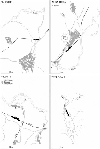
The railway line from Budapest (via Szolnok) arrived in Arad in 1858. During the first half of the nineteenth century, Arad's urban fabric had been undergoing a densification process already started in the previous century.Footnote 15 The station was located in a remote situation, beyond the green, undulating boundary defined by the Muresel canal that separated the town from its rural outskirts (Figure 1). In contrast to the increasingly dense, ordered and clearly bounded urban fabric, the railway was ascribed to the marginality of the rural realm, rather than being effectively part of the town. The station plot was positioned obliquely at the crossing of the east–west and north–south country roads which conferred commercial and strategic importance to Arad, in view of the subsequent continuation of the railway towards Transylvania. The constraints imposed by the marshy nature of the terrain and concern that the continuity of both country roads should not be interrupted meant that the station building never became the visual focal point of the north–south axis that structures Arad's centre. However, the remote railway boundary clearly superseded the canal as the town's northern frontier.
Arad, Radna and Lipova, Deva: schematic town plans at the advent of the railway (1868–70)

Located in between the mountain slopes and the river at one of the Mures valley necks, Radna'sFootnote 16 semi-rural fabric left few options for railway insertion. The line had to follow the northern shore of the river, depriving the back gardens of houses aligned along the country road of their direct contact with the river (Figure 1). Thus, the experience of the river became inseparable from the experience of the railway. Located on Radna's periphery, the railway also occupies a central position, if Radna and LipovaFootnote 17 are considered as a whole. Despite their separate administrative status until the early 1950s, the two towns were connected daily by numerous boats and ferries carrying pedestrians and carriages.Footnote 18 Hence, the railway's presence doubled up with the river as a barrier, but at the same time enhanced the need for communication between the two settlements and stimulated the subsequent bridge construction, as will be discussed further.
Shortly before Deva, the railway trajectory switched to the southern Mures shore, to serve the town and to make the junction with the branch line at Simeria. However, to bypass Deva the line had either to traverse the built-up area, which already touched one of the Mures meanders, or to run along the river, which would have required consolidating the waterfront. Apparently the former alternative was less expensive, so the railway cut through the town's northern district (Figure 1). Although the traversed area was only partly built up, the continuity of the urban fabric was certainly disturbed by the railway's intrusion. Besides the railway right-of-way proper, on both sides of the track, plots were added to the railway property to provide space for signalling boxes, maintenance annexes and safe level crossings. This solution, however, had the advantage of bringing the station relatively close to the town centre. Urban concerns clearly influenced the design too, since the station plot was placed so that the passenger building could be located precisely on the virtual prolongation of the line linking the town centre to the station, despite the fact that the actual street connection was not yet built.
In Orastie, unlike in Deva, the same construction-economy concerns relegated the railway to an extremely remote location (Figure 2). While the country road ascended and descended the hills, the railway trajectory zigzagged through the lower terraces, avoiding as much as possible both the proximity of the river and cutting straight through the foothills, which would have required costly deep trenches or high embankments. Thus, Orastie's station was located at the considerable distance of about 2km from the town's northern limit, and about 3km from its centre, at the junction between the railway trajectory and the recently (1850s) rectified country road.
Orastie, Alba Iulia, Simeria, Petrosani: schematic town plans at the advent of the railway (1868–70)

The trunk line reached its terminus Alba Iulia after crossing the Mures for a second time. Chosen in order to avoid intersecting the meanders of the river Sebes at its junction with the Mures, the position of the railway bridge entailed the interposing of the tracks between the town and the small suburb developed around the salt port, Partos (Figure 2). Though the station was located at the southern margin of the town, its orientation, which was intended both to enable the line's future prolongation to the north and to avoid getting too close to the Mures, required the demolition of a group of houses at the town's periphery. The station was reachable only indirectly, via a little branch of the country road, emphasizing its ‘detachment’ from the urban fabric, its marginality. Prolonged to the north in 1871, the railway line became the town's new external boundary, interposed between the urban fabric and the Mures.Footnote 19 As its meanders came very close to the town, the river constituted a continuous threat. The floods of 1875 and 1877 were especially damaging to the railway.Footnote 20 Consequently, the Mures and the Ampoi courses were deflected away from the town, while half of the Mures canal was filled in. Hence, albeit marginal, the railway accelerated the radical rearrangement of the pre-existing internal and external boundaries of Alba Iulia.
In contrast to the railway's marginality in the pre-existing towns, in the two new towns SimeriaFootnote 21 and Petrosani the railway acted as their foundation axis, while the railway station was their initial centre. Simeria's station and railway works were designed to fit in between the two roads connecting the Mures valley country road with the village of Biscaria,Footnote 22 the eastern road leading to the floating bridge over the Mures and the western road directly connecting the manor house and arboretum with the main road (Figure 2). In Simeria's case, the operational convenience of serving both trunk and branch line at their junction point was certainly the prevailing concern as to the site's choice. The purely utilitarian and economic concerns influencing the location of the station and railway works permanently marked the subsequent development of the town they effectively founded.
In Petrosani, the station's orientation naturally followed that of the river, while its location reinforced the slope-and-pathway boundary between the lower and the higher platforms of the valley (Figure 2). Soon after the railway's arrival, the boom in mining activity occasioned the construction of the first mining colonies on both sides of the track. In the initial situation however, the railway reinforced the pre-existing boundary between the inhabited, lower area and the vacant, higher platform, imposing itself over the hitherto pastoral landscape, and heralding the advent of a different, industrial scene.
This brief review has shown that remoteness or marginality, the initial spatial relation between the railway and the towns, resulted more from the large-scale rationale of the railway line than from concerns for an optimal local-scale insertion. Though theoretically integral parts of the respective towns, therefore, the railway stations appeared as isolated structures, often awkwardly connected to the urban fabric.
Growth towards, along and beyond the railway line
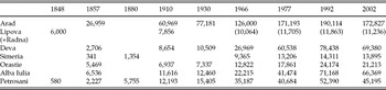
Analysing growth patterns subsequent to the advent of the railway, one finds an equally diverse range of situations, depending both on the town's general growth rate and industrial development, and on the railway's original relationship with the urban structure. Table 1 summarizes the population statistics in the towns since the middle of the nineteenth century. While Arad, the largest of the seven towns, and Petrosani, a real industrial boomtown, witnessed more or less continuous growth across the period, for Deva, Alba Iulia and to some extent Orastie, the period of most rapid population growth was that between 1960 and 1990 with its intensive and state-controlled industrialization. The population growth of the new industrial town Simeria was also continuous, albeit amounting to much smaller figures. Conversely, Lipova's population almost stagnated throughout, under the strong influence of Arad. In all cases population decreased between the 1992 and the 2002 censuses, due to the overall diminution in the birth rate and emigration.
Demographic evolution in the studied towns

Sources: D. Oancea, V. Velcea et al., Geografia Romaniei III. (Bucharest, 1987), 316; Wikipedia; E. Deák, Das Städtewesen der Länder der ungarischen Krone (1870–1918) (Vienna, 1989); I. Bolovan, Transilvania intre Revolutia de la 1848 si Unirea din 1918: contributii demografice (Cluj-Napoca, 2000); T. Rotariu (ed.), Recensamantul din 1857. Transilvania (Cluj, 1997); T. Rotariu (ed.), Recensamantul din 1880. Transilvania (Cluj, 1997).
In Arad the process of incorporating the railway line, which had initially lain outside the town, into the urban fabric started in the final decades of the nineteenth century, the development of the so-called ‘new quarter’ filling the space that separated the station from the rest of the town and also expanding beyond the tracks (Figure 3). Throughout the twentieth century, the town's remarkable growth rate was related to its intensive industrialization.Footnote 23 The 1858 and 1868 approach lines to the station marked out a nearby but isolated, where a large area of railway worker housing, Gradiste, was constructed during the inter-war period, in a system of 500 to 600 square metre plots with individual, detached or terraced single-storey houses. Inter-war workers’ housing areas were also built along the other railway branches, while the high-density and poor-quality socialist apartment blocks filled up the remaining vacant space, especially along the railway branch to Timisoara, or replaced the pre-existing built fabric along the western thoroughfare and in front of the railway station.
Arad, Radna and Lipova, Deva: present-day schematic town plans

Because of its proximity to Arad and the latter's intensive industrialization, Lipova developed at a slow pace, as many inhabitants moved to or worked in Arad.Footnote 24 While urban expansion was limited, the railway's morphogenetic impact was much more significant in structuring and restructuring the pedestrian and vehicle links between the two sides of the river. Although communication by water was always intensive between the two sides of the river, the first bridges were only built in the late nineteenth century. A railway bridge to the west connected the line from Timisoara with the First Transylvanian Railway, and a road bridge to the east connected Lipova's centre to Radna's station; the latter was continued by a contemporary viaduct over the tracks (Figure 3). The old military importance of the place was reaffirmed in the early 1940s, as a large army quarter was established near Radna's monastery. The nineteenth-century railway bridge was demolished in the 1960s and replaced by a new bridge further to the west, making the junction of the two lines smoother. In the same decade, a footbridge over the station's tracks was built in front of the nineteenth-century roadway bridge. The trunk railway's electrification in the mid-1980s engendered the need to replace the old viaduct over the station by a higher one, located more to the west. The old road bridge was still open to traffic until the late 1990s, when the new bridge which extended the new viaduct over the tracks was finished, finally deflecting the increasingly heavy traffic both from the town centre and from the narrower platform of the old bridge. The latter will henceforth only be used by pedestrians and cyclists and remains, after the Franciscan monastery, the second most emblematic building of the place. After the fall of the communist regime, the closure of many large factories in Arad drastically reduced the demand for commuters. Radna's military base also ceased its activities in the 1990s. The municipality, now owner of part of the military base, is currently trying to fight economic and social decay by attracting small industries to the vacant buildings, by revitalizing the town's main natural and cultural assets – Lipova's spa and Radna's pilgrimage church – and finally by taking advantage of the town's accessibility.
Unlike Arad, in Deva, Orastie and Alba Iulia – which are smaller and generally less industrially developed towns – the railway area tended to remain marginal, as long as opportunities for expansion were available elsewhere. Deva's county seat status favoured the constant increase of the town's population during the second half of the nineteenth century.Footnote 25 While the pre-railway urban fabric was organized according to main roads descending along the Mures tributaries, the railway's presence hindered growth in that direction, despite the deviation of the Mures meander and the land consequently gained for potential urbanization. In turn, expansion shifted to the south-east, structured by the Mures valley country road, while growth beyond the railway line was limited to a small inter-war worker housing area, immediately behind the station, of a similar type to the contemporary one in Arad (Figure 3). Accelerated industrialization during the second half of the twentieth century and the related population growth were also accommodated without crossing the railway boundary, through the partial restructuring of the city centre and the construction of new, apartment blocks, including high-rises. The latter transformations also engendered the removal of transit traffic from the town centre by creating a new thoroughfare closer to the railway corridor. An industrial park developed in the south-east triangle between the railway tracks and the new transit road.
Orastie's relatively minor regional status and economic development meant that even after World War II, the urbanized area was roughly the same as in the 1890s. Only a small new residential area appeared north of the town, on the western side of the transit road (Figure 4). This weak link between town and station was prolonged to the north after 1945. Along the so-called Station Street, a timber factory faces a series of modest single-storey, terraced houses. The new civic centre of the 1970s–1980s avoided the station's area as well, being located north-west of the historic core, while areas on both sides of the station were increasingly occupied by industries.
Orastie, Alba Iulia, Simeria, Petrosani: present-day schematic town plans
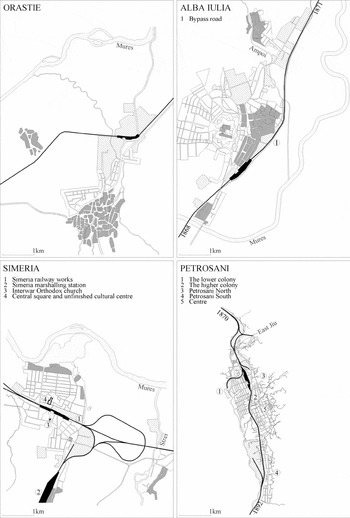
If in Deva and Orastie respectively some residential or industrial areas did develop beyond the railway line, in Alba Iulia the latter remained the town's external boundary until very recently. Before World War I, the town expanded along the centre-to-station connection, but also towards the railway embankment. In the inter-war period, the space left in between the railway line and the built fabric was gradually filled by housing, except for the plots directly adjoining the railway which were occupied by industries.Footnote 26 But the major planned expansion of the period, occasioned by the 1921 agrarian reform, directed development away from the railway line and station areas. By the expropriation and parcelling out of the military defences and drill field surrounding the fortification, a large residential quarter of individual houses was created west of the latter (Figure 4).Footnote 27 The communist period expansions also privileged the north-western side of the town, as new apartment blocks and factories were constructed and many of the central and western housing areas were demolished and replaced by collective buildings. In the early 1990s, a bypass road was built parallel to the railway line, on its eastern side. The bypass will finally end the railway's circumvallating effect, as the recent urban regulations allow construction on parts of its eastern side.Footnote 28
In contrast to Lipova's modest growth, the new industrial towns Simeria and Petrosani developed rapidly around the initial nuclei, the railway stations. The initial centrality of the stations stimulated significant – if uneven – developments on both sides of the track until the second half of the twentieth century, when expansion and/or restructuring started to concentrate on the already more developed side. In Simeria, an initial urban nucleus, formed of individual and collective housing, church, hospital and school, had developed by the end of the nineteenth century north of the railway works and station.Footnote 29 During the inter-war period, the initial nucleus expanded to the north by a set of parallel streets, while the junction with the branch line moved eastwards to make room for the town's southern expansion. During the second half of the twentieth century, the formerly even balance between the two sides of the track inclined towards the northern side.Footnote 30 The original urban nucleus was thoroughly restructured by replacing the original dwellings with apartment blocks and by creating a (still unfinished) civic centre, significantly organized around a square that is partly open towards the railway station (Figure 4).Footnote 31
In Petrosani, the branch line terminus, the first miner colonies were built shortly after the opening of the railway, on both sides of the station: west of the tracks, the colonies and mines of the Brasov Mine and Foundry Corporation; east of the tracks, the colonies and mines of the state.Footnote 32 The urban fabric was organized by a grid of main streets that ran broadly parallel to the railway line. The town's expansion during the twentieth century continued this railway-structured, linear growth pattern towards the south, though development on the two sides of the track was uneven from the beginning.
The previous discussion has revealed that the pre-existing towns tended to appropriate the initially marginal railway station by integrating it within the urban fabric (as in Arad and Deva), yet they avoided expansion beyond the railway boundary as long as there was room for substantial growth in other directions (as in Alba Iulia or in Orastie). Briefly, the railway acted successively as growth magnet and growth barrier. The two new towns, in which growth stemmed from the original nucleus of the railway station, were entirely different. In Simeria and Petrosani the railway was the line that ordered the growth of the settlement, the former town expanding along the perpendicular axis, the latter along the railway line proper.
The railway station and the town centre
If the station-to-centre axis is a major artery of any town, this street and its surroundings did not assume the same morphological and functional character everywhere. Arad's central avenue, leading from the main square to the station, comprises several sections of gradually decreasing central character. South of the Muresel canal, the town's former northern periphery acquired an increasingly central character around the turn of the twentieth century, due to the attraction of the railway station as the end point of the central spine.Footnote 33 However, the relatively high, continuous fronts, with a mixture of functions typical of urban centres did not expand much beyond the canal boundary, where the density of the urban fabric remained lower until late in the second half of the twentieth century. Although the thorough restructuring of the station area during the communist period had increased density by the insertion of middle and high-rise apartment blocks, some of which had commercial ground floors, it nevertheless failed to prolong the high-quality central public space around the station. Thus, although in Arad urban development was clearly accompanied by the expansion of the central area in the direction of the station, the immediate urban context of the latter lacks the architectural quality, spatial coherence and functional diversity of the central area.
In Deva, the station can now be considered part of the town centre, yet this only occurred during the last quarter of the twentieth century, despite its relative proximity to the central square. The station-to-centre street connection was only cut during the late 1930s and the area in front of the station maintained a low-density, residential and peripheral character until the 1970s–1980s, when the old station was replaced by a larger one and the modest street leading to it was transformed into a monumental avenue, flanked by a high-rise development mixing commerce, services and housing. However, the major expansion of Deva's centre followed the town's dominant direction of growth, along the north-west to south-east axis, as discussed above. Thus, although the station avenue conferred central character to the station approach, it was only a secondary axis, unlike Arad where the railway station defines one end of the town's very backbone. Moreover, the major transit road, which cuts off the station from the avenue leading to it, together with the recent additions in front of the station, which lack urban coherence, seriously diminish the potentially central character of the area.
Compared to Arad and Deva, Petrosani illustrates the reverse situation. Here, the initial centrality of the station diminished over time, as the centre of gravity of activity moved away from it. On the eastern plateau overlooking the tracks, the ‘historic centre’ developed within the matrix formed by the two roads which traversed the station at its extremities and focused on the pedestrian link between the passenger building and the market place – central square on the other side of the tracks. As the town expanded southwards, so did the initial central nucleus, and while commerce remained concentrated around the station square throughout the first half of the twentieth century, the more important edifices lay further down the main street, distanced from the station.
Unlike the previous examples, in Orastie and in Alba Iulia the station area remained peripheral, separated from the town centre. In Orastie, the original remoteness of the station had long-lasting consequences for its urban integration. As explained above, the 1970s–1980s civic centre cemented the station area's industrial character. Perhaps given a more coherent planning vision, the task of town extension and the more effective integration of the station with the town could have been correlated. Locating the civic centre between the station and the historic core and organizing the industrial area north-east of the railway line would have enabled the better preservation of the historic core's typology and scale; it would have conferred an urban character to the station–centre link, and would have avoided the polluting presence of industries west of the northern housing area, precisely in the direction of the prevailing wind.
Similarly, in Alba Iulia, the area between the station and the town centre lacks the town centre attributes which characterized this axis in other towns, such as Arad or Deva. The urban fabric maintained the relatively low density (single-storey buildings with discontinuous street fronts) and mono-functionality, which was characteristic of the housing areas usually developed ‘behind’ the track. The economic liberalization of the last two decades brought about the siting of commercial and service facilities along the main street leading to the station, as well as the construction of supermarkets and petrol stations around the station square, but the suburban character of the latter was only reinforced by these particular types of building.
In contrast to both Arad and Deva – where the centre expanded towards the railway station – and to Orastie and Alba Iulia – where the station remained peripheral all along – in Lipova and Simeria the station is both central and peripheral at the same time. Though topographically adjacent to the centre, in both Lipova and Simeria, the entrance hall is separated from the centre by the railway line barrier, as if the station is turning its ‘back’ on the town. This raises the question whether the station itself is located on the ‘wrong side of the track’, discussed in the following section. Briefly, it can be contended that the railway station, as a key element of the urban structure, did not always determine the direction of expansion for the town centre (Arad and Deva, versus Orastie and Alba Iulia), whereas in the two new industrial towns (Simeria and Petrosani) the spatial centrality of the station was frustrated by the railway barrier and even decreased over time (Petrosani).
The emergence of a ‘wrong side of the track’
Areas usually labelled ‘on the wrong side of the track’ are physically affected by a variable-yet-omnipresent combination of topographical and ecological conditions. The former imply segregation from the rest of the town, particularly from the central district, while the latter imply the atmospheric and noise pollution caused by the railway and nearby industries.
In Arad, the ‘new quarter’ developed initially on both sides of the railway station, but the growth of railway traffic, the station's expansion and the poor provision of railway crossings engendered the increasing differentiation between the two sides of the track and strengthened the railway's barrier effect so that the inter-war workers’ quarter, Gradiste, was increasingly isolated. With similar plot and house sizes to other contemporary residential areas of the town, the quarters Gradiste and Micalaca were also the most affected by the pollution sent in their direction by the dominant winds (from the west and north-west).Footnote 34 On the would-be ‘right side of the track’, the architect Silvestru Rafiroiu's inter-war plans tried to balance the densification pressure created along the station-to-centre axis with the need to provide green spaces for an increasingly industrialized town, as shown by Anghel.Footnote 35 Rafiroiu proposed the preservation and extension of the open spaces along the Muresel canal and their transformation into a large park which would act as a green filter between the industrial area developed mainly on the town side of the track and the centre. At the same time, a new, higher-status residential area – the ‘clerks’ quarter’ – was planned at the park's western extremity.Footnote 36 Ironically, today the quarter Gradiste is comparatively a calmer and greener living area thanks to its isolation, while Rafiroiu's ‘clerks’ quarter’ and what remains of the generously planned park lost much of their initial quality under the pressures of centralization and accessibility. Nevertheless, the preservation of a relatively calm, low-density residential area suffers the drawback of the awkward connection with the urban amenities mostly located on the ‘right side of the track’: the south–north transit road viaduct is currently the only formal link across the wide area of the station.
In Deva, in addition to the railway's intrinsic barrier effect, the relocation of the transit road along the railway line in the 1980s increased the isolation of what could be called Deva's ‘wrong side of the track’, the small housing and industrial quarter developed behind the station. As in Arad, pollution exacerbated this disadvantage, since the dominant winds coming from the north-west sent pollution from the railway station to the same area. Further, unlike Arad, the area is disadvantaged by the lack of any important regional transport links crossing the railway line, so that only level-crossing links with the town are available for the inhabitants of the ‘wrong side’, while they are completely dependent on the ‘right side’ for all urban services.
In the mining town of Petrosani, the railway acted both as the axis structuring growth and as the boundary between a dominant and a subordinated side of the track. The first miner colonies were designated according to the station's boundary position between the higher and the lower terraces, as the ‘lower’ and respectively the ‘higher colony’ (Figure 4).Footnote 37 Yet development on the two sides of the track was uneven from the beginning. First, the lower colony was the most affected by the soot and ashes produced in the station, as the prevailing winds blow from north-east to south-west. Also, on that side, non-housing functions continued to be the exception, while most senior personnel houses and urban amenities were grouped in the upper (eastern) part of the town. The expansion of the early 1970s strengthened the disparity between the two sides of the track, by opposing the large ‘bedroom quarter’ of Petrosani Sud to the newly open Livezeni mine. This, together with the restructuring of the old centre in the 1980s, diminished the railway's role in defining the town's areas, as the ‘north–south’ delineation started to prevail over the ‘lower–higher’ delineation. In this period, the railway's barrier effect was further increased through the doubling of the line, but also through the construction of a new thoroughfare east of the railway, removing the transit traffic from the city centre. The closure of most mines in the late 1990s increased the already existing discrepancy between the ‘colony’ and the rest of the town, as its company houses are mostly inhabited by poorer immigrant miners, most of whom have become unemployed, so that the quarter is now among the most socially vulnerable in the Jiu valley.Footnote 38 Despite the presence of a footbridge and of a viaduct, necessitated by the atypical location of the passenger building and of mining industries on the ‘wrong side’, the inferior status of the area is also denoted by the insufficient frequency of designed railway crossing points, resulting in the emergence of several spontaneous level crossings.
However, the examined cases show that ‘a wrong side of the track’ did not emerge everywhere. In contrast to Arad, Deva and Petrosani, in Orastie the areas adjoining both sides of the railway are rather similar. Both are predominantly industrial and the housing areas on the town side of the track are affected by the polluting effect of traffic and industry. Thus, what is potentially the ‘right side’ of the track is affected by problems characteristic of the ‘wrong side’ too (pollution, as the dominant winds blow from the north-west, and the lack of urban amenities, due to the predominantly industrial character of the area). Equally exceptional is Alba Iulia, where the railway's long-lasting marginality is only just being brought to an end, so the future will show what kind of relationship will emerge between the new developments and the existing town.
Rather different are Lipova and Simeria, where the complementary character of the two sides of the track resists the ‘right’ and ‘wrong’ delineation. While situated opposite each other, Radna and Lipova have been historically marked by many differences, so that the railway was inserted in between the two areas on either side of the track which were already distinct.Footnote 39 The railway station became the pole around which their relationship was organized, just as the wharf had been before the construction of a bridge in the late nineteenth century. The wharf, and later the station, represented the hinge articulating the through traffic with the local traffic. Although it did not cause the differences between the two sides of the river, the railway has certainly enhanced their complementarity. Given their strong interdependence, neither side of the track could be labelled ‘the wrong one’. While the main road and rail traffic venues, as well as the most iconic places, belong to Radna, most commercial, administrative and educational amenities are located in Lipova. Moreover, the potential resources for sustainable economic redevelopment are now split between the two: Lipova's spa and Radna's former military complex await revitalization and functional conversion respectively. At the same time, it can be argued that it was the specific layout of the station complex that helped cement the pre-existing urban-versus-rural contrast between Lipova and Radna. The decision to place the station close to Radna missed the opportunity of creating a publicly accessible waterfront there with urban character, as in Lipova. Instead, it is the station yards that back on to the river. The alternative scheme would have afforded the town a public and more iconic waterfront, albeit only accessible over a viaduct. To be sure, I am not arguing that the original planners placed the station building ‘on the wrong side of the track’. The chosen scheme was coherent with the initial independent status of Radna. However, the consequences teach a lesson about the long-term impact of the railway boundary on urban development.
A similar inversion appears in both Simeria and Petrosani, where the central nucleus developed on the track side opposite the station building, in other words, at the ‘back’ of the station. Though both the railway and the mining town are the result of planned developments, these were informed by industrial efficiency and construction-economy rather than by urban concerns. But the essential difference between Simeria and Petrosani is that in the former the country road also runs on the less-developed potentially ‘wrong side of the track’. Thus, the station complex, the town's ‘historic core’, becomes a sort of inaccessible central square; however, it is a square that has to be experienced visually and traversed, as it connects the town's most important sites. Also, Simeria's important inter-war symbol, the Orthodox church, was not built on the main side of the town, but ‘in front’ of the station, on the more visible site afforded by the traversing country road. The Transylvanian Orthodox churches of the inter-war period were part of the unifying project of the newly enlarged Greater Romania. They systematically occupy privileged locations within the urban structure, reinforcing their symbolic function as carriers of national identity.Footnote 40 Thus, in Simeria one could hardly speak of a ‘wrong’ and ‘right’ side of the track, given the complementary character of the two parts of the town, unlike in Deva or Petrosani, where the relationship is unidirectional.Footnote 41
The railway boundary as contested barrier
The seven case studies examined in this article have provided the opportunity of comparing the divisive tendencies of the railway in contrasting urban contexts, which shared, however, both the timing of their connection to the railway system and the same railway company as promoter. The analysis of the initial town-and-railway spatial relationship has shown that despite the significant differences in size and regional importance, a similar insertion strategy prevailed in all pre-existing towns: the marginal or even remote location of the railway line and station resulted mainly from the large-scale construction-economy and operation-efficiency rationale of the railway line, rather than from concerns for the local-scale integration in the urban structure. In Arad, the fact that it was a terminus for ten years, together with the existence of the barrier to growth represented by the river Mures to the east and south, directed expansion from the outset to the area behind the tracks. In Deva, Orastie and Alba Iulia, however, the subsequent urban growth avoided crossing the tracks as long as opportunities for development were available in other directions, which suggests that the potential barrier effect of the railway boundary was realized from early on. Conversely, in the new towns Simeria and Petrosani the founding role of the railway station as the initial urban nucleus entailed growth on both sides of the track. The relationship between station and centre was variable, too. While central expansion occurred in the direction of the station in both Arad and Deva (as late as the 1980s in the latter) the station's front, however, failed to acquire the functional diversity, high-density and spatial coherence of central areas, mainly because of the poor quality of both communist and post-communist interventions. Apparently the prevailing urban vision of the station squares was simply utilitarian, as traffic nodes, rather than as (peri-)central public spaces. This is most obvious in Orastie and Alba Iulia, where the station's front maintained its initial peripheral character all along, and also in Petrosani, where the initial centrality of the station was altered, along with the town's linear expansion.
Areas that were positioned unfavourably in relation to the prevailing winds, and which were affected by the intrinsic barrier effect of the railway, aggravated by the poor provision of crossing points, can be considered to have been, in an urban sense, ‘on the wrong side of the track’ (Arad, Deva or Petrosani). Interestingly, the radical transformations of the communist decades, altering the content, density and scale of urban space altogether, concentrated largely on the main, ‘right side of the track’ in each case, emphasizing the symbolic delineation between the two sides. Thus the railway barrier in a way preserved the pre-existing areas of workers’ housing from destruction, and hence, the individual versus the collective dwelling. But a ‘wrong side of track’ did not emerge everywhere. In Orastie both sides have been affected by the same topological and ecological problems associated with the ‘wrong side’. Conversely, in Lipova and Simeria the complementary character of the two sides resists such a contrast being drawn.
If the city wall embodies the archetypal urban boundary, where the gates as ‘escapes’ puncture the continuity of the stability-providing enclosure, the railway in the city suggests the reverse image. The railway crossings attempt here and there to retrieve the local continuity, undermined by the exclusive right-of-way of the escape-providing railway line.Footnote 42 Consequently, the frequency, typology and location of urban railway crossings both denote and determine the relative status of areas adjoining the tracks. The most affected in each case are the pedestrian links, either frustratingly long when viaducts are used, or excluding certain users when footbridges are concerned, or simply unsafe in the case of (often improvised) level crossings. This study has tried to show that the urbanization-without-urbanism which sometimes surrounds the railway is rooted in a poor understanding of its functions as a boundary, and of how the barrier of the railway might be rendered permeable for local and distant communication purposes. Simultaneously transcending the local scale and being necessarily an intrinsic part of the city, the challenge to planning created by the railway always remains one of mediation between the desire for distant communications and the desire for diverse, yet continuous and accessible urban space.