Aztec scholars have spilled much ink delimiting the extent of the empire's expansion toward the Isthmus of Tehuantepec, particularly in the southern Gulf lowlands. With each ethnohistorical reassessment of the tribute tallies of the three imperial allies (Tenochtitlan, Tlacopan, and Texcoco), the eastern boundary has expanded and contracted across the Sierra de los Tuxtlas, located in the modern Mexican state of Veracruz (Barlow Reference Barlow1949; Berdan Reference Barlow, Berdan, Blanton, Boone, Hodge, Smith and Umberger1996; Berdan and Anawalt Reference Berdan and Anawalt1992; Carrasco Reference Carrasco1999; Esquivias Reference Esquivias2003; Gerhard Reference Gerhard1993). In Barlow's (1949) more generous boundary ascription, the majority of the Tuxtlas region appeared incorporated. On the other hand, Berdan (Reference Barlow, Berdan, Blanton, Boone, Hodge, Smith and Umberger1996:Figure 5-2) retracted the eastern boundary of Tochtepec westward, confining it to the course of the Papaloapan (Alvarado) River. Berdan's realignment of Tochtepec's eastern boundary resulted in the Tuxtla Mountains appearing entirely autonomous of imperial control (Berdan 1996). Both Barlow's (1949) and Berdan's (1996) drawing of the eastern imperial boundary was based on tributary information recorded in the sixteenth-century Codex Mendoza. As Urcid and Esquivias (Reference Urcid and Esquivias2000) point out, at least part of the confusion regarding previous placements of this boundary was due to a printing error on Barlow's map. Berdan's tentative placement of Toztlan along the Papaloapan near the provincial capital Tochtepec reflected this error and perpetuated the exclusion of the Tuxtlas in subsequent publications (for example, Smith and Berdan Reference Smith and Berdan2003).
Esquivias' (2003; see also Urcid and Esquivias Reference Urcid and Esquivias2000) and Carrasco's (Reference Carrasco1999) interpretations of ethnohistoric and early colonial documentary evidence helped to correct the placement of the empire's eastern boundary and to reestablish the Tuxtlas as being within its limits. To redefine and re-expand the extent of expansion toward the isthmus, Carrasco (Reference Carrasco1999) used the complementary Memorial de Tlacopan in concert with other documents and the Codex Mendoza (Berdan and Anawalt Reference Berdan and Anawalt1992). Esquivias' (2003) review of colonial era documents concerning the town of Chacalapan in particular aided the boundary's refinement within the southern Tuxtla foothills near the San Juan River.
The correct placement of the eastern boundary of Tochtepec in the Sierra de los Tuxtlas is further supported by the late sixteenth century Relaciones Geográficas (RG), and more specifically the Relación de Tlacotalpan (RT) contained therein (Paso y Troncoso Reference Paso y Troncoso1905). Using these colonial survey data, Gerhard (Reference Gerhard1993:341) shows the eastern boundary between imperial tributary Toztlan (Tustla or Tuxtla) and Coatzacoalcos as lying at Lake Catemaco. Similarly, García Martínez (Reference García Martínez1969) shows the eastern boundary of the Tuxtla district of the Cortés Marquesado to the immediate east of the same lake.
Using independent linguistic and ethnographic evidence, Foster (Reference Foster1943) suggested that Lake Catemaco formed a linguistic boundary between the primarily Nahuat-speaking western Tuxtlas and the primarily Sierra Popoluca (Mixe Zoque)-speaking eastern Tuxtlas. These Nahuat groups may have migrated into the region and pushed many Sierra Popoluca eastward and out of the more fertile parts of the western Tuxtlas (see also Umberger [1996] for a brief mention of the pre-Aztec Postclassic migration of Nahuat speakers into Toztlan). The initial arrival dates of Nahuat-speaking groups (Pipil) may have been as early as the very late Late Classic/Epiclassic or Early Postclassic period. Kaufman's (2001; see also Kaufman and Justeson Reference Kaufman, Justeson, Arnold and Pool2008) appraisal of linguistic data supports this arrival time approximation, which may be archaeologically reflected in the Soncautla complex of Tres Zapotes (Coe Reference Coe and Willey1965; Pool Reference Pool1995) and the Vigía phase at Totogal (Venter Reference Venter2008, Reference Venter2010). Immigration occurred during the Late Postclassic period as well, when unknown numbers of individuals associated with Aztec expansion settled in the region (Umberger Reference Umberger, Berdan, Blanton, Boone, Hodge, Smith and Umberger1996; Venter Reference Venter2008, Reference Venter2010). The RGs indicate that at least some imperial newcomers resided in Toztlan for the purpose of administering the collection of tribute (Paso y Troncoso Reference Paso y Troncoso1905). While the origin and scale of these Late Postclassic arrivals is uncertain, if they were from core areas of the Aztec Empire, then they might have been Nahuatl-speakers. Thus, by the 1520s, the multiethnic Tuxtlas may have included Nahuat and Mixe Zoque majorities and a Nahuatl minority.
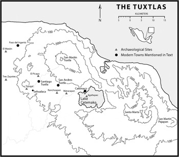
The RT (Paso y Troncoso Reference Paso y Troncoso1905), Carrasco (Reference Carrasco1999), Esquivias (Reference Esquivias2003), García Martínez (Reference García Martínez1969), Gerhard (Reference Gerhard1993), Killion and Urcid (Reference Killion and Urcid2001), Pool (Reference Pool1995), and Urcid and Esquivias (Reference Urcid and Esquivias2000) all clearly associate the sixteenth-century cabecera of the Tuxtla district with the colonial and modern town of Santiago Tuxtla (Figure 1). Spanish administrators typically grafted their viceregal superstructures onto preexisting locally configured Aztec systems. Therefore, in areas included within that imperial net, we can cautiously infer that many early colonial cabeceras were centers atop Late Postclassic hierarchies (Gerhard Reference Gerhard1993; Lockhart Reference Lockhart1992). This cooption of imperial networks and relationships facilitated the establishment and integration of the colonial enterprise over disparate and distant territories. By extension, in the Sierra de los Tuxtlas, we can infer that the immediate region around colonial Santiago Tuxtla represented the administrative core of the Late Postclassic Toztlan tributary.
Totogal, Santiago Tuxtla, and other Tuxtlas region sites and towns (after Venter Reference Venter2008:Figure 2-1).

Carrasco's (Reference Carrasco1999) redrawing of the Tochtepec province in particular was the basis for Esquivias' (2003) ethnohistorical and archaeological study of the eastern Aztec frontier. Her work near Chacalapan was spurred by a lack of Postclassic archaeological knowledge of the southern Gulf lowlands (Killion and Urcid Reference Killion and Urcid2001; Pool Reference Pool1995; Santley and Arnold Reference Santley and Arnold1996) and by mention made in the RT of conflicts between Toztlan and the independent polity of Coatzacoalcos near Chacalapan (Esquivias Reference Esquivias2003; Paso y Troncoso Reference Paso y Troncoso1905). Unfortunately, Esquivias's archaeological study of the Toztlan-Chacalapan boundary was hindered by an inability to distinguish Late Postclassic material culture from that of preceding periods, especially the Late Classic (Esquivias Reference Esquivias2003). This problem has plagued archaeological research in the Tuxtlas and wider central and southern Gulf lowlands (Stark Reference Stark, Berdan, Chance, Sandstrom, Stark, Taggert and Umberger2008) since Santley and colleagues' initial work at Matacapan and in the surrounding Catemaco valley (Santley and Arnold Reference Santley and Arnold1996). Research conducted at Agaltepec in 2002 (Arnold Reference Arnold2003; Arnold and Venter Reference Arnold and Venter2004) and at Totogal in 2004 (Venter Reference Venter and Pool2005, Reference Venter2008; Venter and Pool Reference Venter and Pool2005) refined the Postclassic segment of the regional chronology. With stratigraphic excavation and corresponding radiometric dating, we identified local and nonlocal artifacts and material patterns that can be used in revisions of existing site sequences and applied to new regional surveys to obtain a more accurate picture of demographic trends (Stoner Reference Stoner2011; Venter and Stoner Reference Venter and Stoner2009). Finally, this study facilitated an examination of different types of imperialism. After consideration of possible imperial-local interactions (Skoglund et al. Reference Skoglund, Stark, Neff and Glascock2006; Stark and Chance Reference Stark, Chance and Smith2011), a new model is proposed that emphasizes the mediating strategies of local groups.
THE HISTORICAL EVIDENCE
Unlike several hispanicized Early Colonial period communities in Mesoamerica and the Tuxtlas (for example, Catemaco), the current town of Santiago Tuxtla does not directly overlay its pre-Hispanic antecedent. During the colonial founding of Santiago Tuxtla, Spaniards relocated the pre-Hispanic settlement from its original location to its present site, possibly to concentrate and control the population (Gerhard Reference Gerhard1993; Medel y Alvarado Reference Medel y Alvarado1993; Rivas Castellanos Reference Rivas Castellanos1999). Totogal, I argue, represents the pre-colonial forerunner of Santiago Tuxtla. I also suggest that it was the primary imperial contact node in the southwestern Tuxtlas. As such, it may have functioned as the principal tribute administration center. But Totogal was not the only Late Postclassic center in the region, or the only one that engaged in interactions (direct or indirect) with the Aztecs.
Information from recent site-based archaeological fieldwork, documents, local oral accounts, secondary written sources, and early exploration reports support the identification of Totogal as the imperial administrative center of Toztlan, a tributary in the Aztec empire's easternmost Gulf lowland province Tochtepec (Blom and La Farge Reference Blom and Farge1926 Friedländer and Sonder Reference Friedländer and Sonder1923; Medel y Alvarado Reference Medel y Alvarado1993; Ortiz Ceballos Reference Ortiz Ceballos1975; Rivas Castellanos Reference Rivas Castellanos1999; Seler-Sachs Reference Seler-Sachs and Lehmann1922; Venter Reference Venter2008). Comparisions made between Totogal, Agaltepec, and other Late Postclassic sites in the Tuxtlas indicate that Totogal had more direct interactions with the Aztecs (Venter Reference Venter2008; Venter and Stoner Reference Venter and Stoner2009). The importance of Totogal in the western Tuxtlas is also strengthened by the findings of the Tuxtlas Survey of the Catemaco Valley (Santley and Arnold Reference Santley and Arnold1996), the Hueyapan Survey (Killion and Urcid Reference Killion and Urcid2001), and Stoner's (2011) survey of the Tepango Valley. None of these studies identified contemporaneous centers of Totogal's scale or with the same intensity of imperial interactions.
Sixteenth-century Toztlan became known as Tuxtla by ca. 1525–1531, soon after initial Spanish entrance into the area. The Tuxtla encomienda, awarded to Cortés by a royal decree, encompassed the western Tuxtlas as well as the eastern Lower Papaloapan lowlands (Gerhard Reference Gerhard1993). Tuxtla (Santiago Tuxtla) was also the name of the district's colonial capital. The town of Tuxtla oversaw six subject towns: San Andrés Zacualco (later renamed San Andrés Tuxtla), Matlacapa (Matacapan), Caxiapa (uncertain, but either on the coast [Juan Palagot, personal communication 2004] or along the middle course of the Catemaco River [Blom and La Farge Reference Blom and Farge1926]), Chuniapa (Chuniapan), Catemaco (modern Catemaco and environs, probably including Agaltepec), and Conchihca (unknown) (Paso y Troncoso Reference Paso y Troncoso1905; see also Bermudez Gorrochotegui Reference Bermudez Gorrochotegui1978; García Martínez Reference García Martínez1969; Gerhard Reference Gerhard1993; Pool Reference Pool1995; Stark Reference Stark, Stark and Voorhies1978). Late Postclassic sites have been identified at or near several of these colonial towns, suggesting some measure of settlement continuity. Tototepec and Matacanela may have been centers during the Late Postclassic period as well. Tototepec appears in the Memorial de Tlacopan (Carrasco Reference Carrasco1999; see also Barlow Reference Barlow1949). It is also indicated on a map of the Cortés estate, where it was placed in the vicinity of San Andrés near Sihuapan and Matacapan (García Martínez Reference García Martínez1969). But survey of this area did not identify a Late Postclassic site at or near this suggested location (Santley and Arnold Reference Santley and Arnold1996). Matacanela is an archaeological site south of Lake Catemaco that has produced several Late Postclassic stone monuments (Blom and La Farge Reference Blom and Farge1926; Coe Reference Coe and Willey1965).
As the colonial provincial capital, Tuxtla, or Santiago Tuxtla, was the administrative, economic, and Catholic central place through the end of the seventeenth century. During the first century of colonial rule, it also was the primary population center. The total Indian population of the town of Tuxtla totaled 1,815 in 1568, and it was 1,846 in 1595 (Cook and Borah Reference Cook and Borah1979:51). The population data presented by Cook and Borah (1987) indicate that Tuxtla had one of the higher Indian population totals along the Gulf Coast. In addition, the native population of Tuxtla is one of few in the devastated coastal region that did not see dramatic decreases between the two discussed years, possibly because of its more favorable mountain climate (compare other towns in Region III [Cook and Borah 1987:51]). The town of Tuxtla declined in economic importance before the end of the colonial era, as nearby San Andrés Tuxtla (formerly Zacualco) eclipsed Santiago's influence in the region. Santiago Tuxtla is still the seat of a municipality of the same name, though its territory is much smaller than it once was. Santiago Tuxtla, along with San Andrés Tuxtla, and Catemaco are the largest settlements in the Tuxtlas today.
Rivas Castellanos (Reference Rivas Castellanos1999), citing transcriptions of pre-Revolution municipal archives made by Antonio Verdejo y Tenorio, suggests that the waning of Santiago's authority was due to volcanic activity that had a greater impact on Santiago than on San Andrés (for similar episodes of earlier volcanism and their different regional impacts, see Santley Reference Santley, Inomata and Webb2005). He states that many inhabitants of Santiago relocated to San Andrés during the 1664 eruption of the San Martín Tuxtla volcano (see also Medel y Alvarado Reference Medel y Alvarado1993). Some people returned to Santiago following the eruption, but many apparently remained at their new home. It is very possible that volcanic activity affected the regional distribution of Tuxteco populations and that an episode of volcanism contributed to Santiago's decline as a regional power. Other factors, however, such as tobacco farming and cigar production (perhaps improved by a population surge to provide a larger labor force) equally contributed to San Andrés' economic growth.
Totogal is located between 300 and 400 m asl on the southeastern slopes of Cerro el Vigía, the extinct volcano to the immediate west of Santiago Tuxtla. Cerro el Vigía is located mid-way between the Preclassic-to-Early Postclassic period site of Tres Zapotes and Santiago Tuxtla (Figure 1). The largest colossal Olmec head, which is currently displayed in Santiago Tuxtla's central square, was found at Cobata near one of Vigía's peaks. According to the Instituto Nacional de Estadística y Geografía (INEGI), the population of Totogal was 16 in 2005; in 2010 it was 27. In 2004, four houses were located within the surveyed portions of the site. Because of the sparse occupation since its colonial abandonment, as well as its remote location, the site is well preserved.
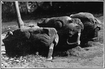
Despite the prominence of Cerro el Vigía on the landscape and the proximity of the Cobata head, Totogal has escaped the direct attention of most scholars working in the southern Gulf lowlands. There are, however, several allusions to the site. Most remarks concerning Totogal are from the early twentieth century and are in reference to the Postclassic-style monuments found today in San Andrés Tuxtla's community museum (Figure 2). For example, Blom and La Farge (Reference Blom and Farge1926:19–20) refer to ruins on the southern side of the “Santiago volcano” as the source of Postclassic-style stone monuments they observed in San Andrés (see also Seler-Sachs Reference Seler-Sachs and Lehmann1922:Figure 2). Other references are more direct in their mention of the site. For example, Friedländer and Sonder (Reference Friedländer and Sonder1923) and Porter (Reference Porter1989) attribute the basalt sculptures specifically to Totogal. Early twentieth-century informants apparently told Friedländer that at an unknown date, the basalt sculptures were moved from Totogal to Santiago; later, in the early twentieth century, they were relocated to San Andrés (Friedländer and Sonder Reference Friedländer and Sonder1923:165). They were only recently installed in the museum there. They were previously in the unprotected town square.
Basalt monuments from Totogal (adapted from Blom and La Farge 1926:Figure 16).

Additional references to Totogal and to Cerro el Vigía also come from Friedländer and Sonder, who indicated that the “mountain [Cerro Santiago] was a heiligtum (sacred place, sanctuary) to the Indians” (1923:165 [translation mine]). Gerhard (Reference Gerhard1993) referred to the naturally fortified mountain position of the Conquest period settlement, a setting that does not characterize Santiago Tuxtla. Finally, Medel y Alvarado (Reference Medel y Alvarado1993) mentioned a settlement on Totogaltepetl (literally Totogal Hill; also Cerro el Vigía, Cerro de Tuxtla) that was the home of Santiago Tuxtla's indigenous population prior to early colonial resettlement (see also Ortiz Ceballos Reference Ortiz Ceballos1975; Rivas Castellanos Reference Rivas Castellanos1999). Totogal continues to be referred to as “Tuxtla Viejo” by some in Santiago today (Clemente Campos, personal communication 2004; see also Rivas Castellanos Reference Rivas Castellanos1999).
Despite these mentions of the site at Totogal, no ethnohistorians or archaeologists attempting to associate Tuxtla with an archaeological settlement previously considered the site in published sources. For example, in hypothesizing the location of pre-Hispanic Tuxtla, Killion and Urcid (Reference Killion and Urcid2001:16, Footnote 5) suggested that nearby Classic period El Picayo (Totocapan) was the best candidate because it was the only known large center in the immediate region, and some Late Classic or possible Early Postclassic ceramics were recovered there by Valenzuela (Reference Valenzuela1945). My own perusal of local histories and conversations with Ponciano Ortiz and other personnel from the Instituto Nacional de Antropología e Historia (INAH) suggested, however, a correspondence between Totogal and the indigenous populations that later were removed to Santiago Tuxtla (Ponciano Ortiz, Juan José Palagot, and Clemente Campos, personal communication 2003).
Philip Arnold and I made a brief visit to the site in 2003. At that time, we observed two modest mounds and the remnants of stone masonry walls. Moreover, ceramics in a small on-site arroyo were similar to those recovered at Late Postclassic Isla Agaltepec, studied the year before (Arnold and Venter Reference Arnold and Venter2004); these materials helped to confirm not only pre-Hispanic habitation, but also that the occupation might be contemporaneous to that site.
Throughout Nahuatl-speaking areas of the central highlands, the word “house” (calli) was sometimes used in reference to the settlements that housed local authorities (for example, teccalli [noble house]) (Lockhart Reference Lockhart1992). Similar use in the Nahuat-speaking Tuxtlas, where the term for house is “kal” (Campbell Reference Campbell1985:41), is not certain, but at least two Late Postclassic Tuxteco centers contain this referent: Isla Agaltepec (water-house-hill) and Totogal (depending on the referent, tototl or totolin means either “house of the birds” or “house of the turkeys”) (Karttunen Reference Karttunen1992). In both of these toponyms, the use of the consonant “g” may relate to Nahuat/Pipil- or Spanish-based spelling systems (see King Reference King2004; Schultze Reference Schultze1935). Archaeological investigations at Agaltepec suggest that the small, near-shore island may have been a refuge for local leadership in the Catemaco area during a time when competition and “mutual suspicion” may have characterized relationships in the region (Scholes and Warren Reference Scholes, Warren and Willey1965). The regional settlement pattern in the Tepango Valley suggests a similar function for Totogal. These etymological clues alone are not confirmation of Totogal's status, but they do lend additional support to the archaeological evidence that indicates Totogal was a seat of local leadership.
It is too early to speculate if the Tuxtlas were characterized by precisely the same organizing principles that governed geopolitical relations in highland altepemeh. However, other similarities that include rare provincial Huitzilopochtli worship (Umberger Reference Umberger, Berdan, Blanton, Boone, Hodge, Smith and Umberger1996:7, Note 1; Urcid and Esquivias Reference Urcid and Esquivias2000), trade and imperial interaction, payment of tribute, and oversight (by way of the resident calpixqui) indicate that some highland organizational models may be applicable to the western Tuxtlas during the Late Postclassic period, if not earlier. Additional support comes from language descriptions soon after the Spanish conquest (Paso y Troncoso Reference Paso y Troncoso1905[5]:5). Many central and southern Veracruz provinces had significant numbers of “Mexican” language speakers (Stark Reference Stark, Berdan, Chance, Sandstrom, Stark, Taggert and Umberger2008; Umberger Reference Umberger, Berdan, Blanton, Boone, Hodge, Smith and Umberger1996). Umberger (Reference Umberger, Berdan, Blanton, Boone, Hodge, Smith and Umberger1996:159) states that the description of Tuxtla's (Toztlan's) “Mexican” language as “rough” or “corrupt” probably means that it came with pre-Aztec migrations of Pipil into the area who spoke the Nahuat dialect unlike later highland populations who spoke Nahuatl (Campbell Reference Campbell1985; Fowler Reference Fowler1989; Kaufman Reference Kaufman2001; Scholes and Warren Reference Scholes, Warren and Willey1965:780). Umberger (Reference Umberger, Berdan, Blanton, Boone, Hodge, Smith and Umberger1996) points out that Toztlan was unique among provincial tributaries for its purported Huitzilopochtli worship, Huitzilopochtli being the patron deity of the Mexica ethnic group.
Despite preliminary research at the Archivo General de la Nación (AGN), I was not able to locate records that specifically mentioned Totogal. More time and a closer review may yield more positive results, but my examination of documents in the Hospital de Jesus section of the AGN only revealed later colonial records of Tuxtla. These manuscripts postdated its Hispanic resettlement by a few decades. Eneas Rivas Castellanos (Reference Rivas Castellanos1999), Santiago Tuxtla's modern chronicler, indicates that the Archivo General de Indias (AGI) in Sevilla mentions Totogal. He does not, however, indicate which documents contain this information. Medel y Alvarado (Reference Medel y Alvarado1993; see also Ortiz Ceballos Reference Ortiz Ceballos1975) also describes this forced relocation from Totogal, but he does not cite his sources. Rivas Castellonos (1999) and Medel y Alvarado (Reference Medel y Alvarado1993) both refer to information that may have once been in the town archives, but that is reported to have burned during the Revolution. Verdejo, the former town chronicler, is said to have written down what he could remember of the basic story outlines. That story is related in Rivas Castellanos (Reference Rivas Castellanos1999:21–22).
Local tradition, transmitted over several generations, suggests a storied past for the founders of Totogal (Verdejo, cited in Rivas Castellanos [1999:21–22]). This tradition relates the migration myth of a group from Tlaxcala that made war with the inhabitants of the Gulf region, specifically Cotaxtla. As a result of battles between this transient group and Cotaxtla, they continued their migration to the east, arriving at what is today Arroyo Largo (one town with this name is south of Tres Zapotes and southwest of Totogal; the other is north of Tres Zapotes). Upon arrival, they established a large center and their settlements extended to the Cerro de Tuxtla (Cerro el Vigía) and its surrounding valleys. Once at Arroyo Largo, the foreigners remained for several years, but extensive flooding of the site forced them to relocate. During this final migration, the center's population allegedly settled at upland Totogal and founded Tuxtla (translated from Verdejo, cited by Rivas Castellanos [1999:21–22]).
In this account, Verdejo does not mention the municipal archives that he transcribed, but they and oral tradition likely informed part of his narrative. Unfortunately, there is no simple way to substantiate the specifics of Verdejo's migration account as they relate to Totogal, although conflict between Tlaxcala and Cotaxtla is well documented in other sources (Durán Reference Durán and Kintana1967; Ohnersorgen Reference Ohnersorgen2006). An unfortunate downside to oral traditions accumulated over several centuries is that they are likely to suffer significant alterations and embellishments. Therefore, we cannot place much confidence in this particular migration story, especially since no primary sources were available for study.
Despite the uncertainty surrounding Verdejo's account, the often-cited Nahuat migrations into the Gulf lowlands may account for some of the changes that occurred during the Postclassic period (Daneels Reference Daneels, Stark and Arnold1997; see also Foster Reference Foster1943; Scholes and Warren Reference Scholes, Warren and Willey1965:779–780), especially when one considers the linguistic evidence. The pre-Aztec Nahuat migrations would account for the “corrupt” version of “Mexican” spoken in Tuxtla at Contact (Umberger Reference Umberger, Berdan, Blanton, Boone, Hodge, Smith and Umberger1996). These migrations were allegedly by “Popoluca” (foreign) groups (also designated as Olmeca) from the central highlands who, following the twelfth-century decline of Tula and Tolteca-Chichimeca pressures, moved southeastward to the Gulf Lowlands “where they established petty kingdoms, or señorios” (Scholes and Warren Reference Scholes, Warren and Willey1965:780, citing Mayas y Olmecas 1942; see also Jiménez Moreno Reference Jiménez Moreno1942). The “Popoluca” allegedly associated with these migrations, however, are not to be confused with the Mixe-Zoque-speaking Sierra Popoluca who occupy the eastern Tuxtlas today (Foster Reference Foster1943; Kaufman Reference Kaufman2001). Speakers of the Mixe-Zoque language were living in the Tuxtlas for many centuries prior to the arrival of Nahuat speakers (Kaufman Reference Kaufman2001; Kaufman and Justeson Reference Kaufman, Justeson, Arnold and Pool2008).
Documentation of Totogal resumes with accounts of the Early Colonial period. Records maintain that following initial entrance into the Tuxtlas, Hernán Cortés, having encountered the native population of Totogal and claimed right to the land, tributes, natural resources, and labor (Bermudez Gorrochotegui Reference Bermudez Gorrochotegui1978; Gerhard Reference Gerhard1993), demanded that the indigenous inhabitants of Tuxtla (Totogal) descend the mountain and relocate (Rivas Castellanos Reference Rivas Castellanos1999). A portion of the native population settled in the Barrio del Marqués in Santiago Tuxtla (Rivas Castellanos Reference Rivas Castellanos1999). This barrio still exists on the slopes east of Highway 180 as it enters town from the northwest. (This is the barrio closest to the Totocapan section of El Picayo.) Rivas Castellanos (Reference Rivas Castellanos1999) notes that the Spaniards allowed 40 days for the depopulation of Totogal. This forced resettlement, perhaps initiated as part of the 1531 reducciones throughout New Spain, is stated to have occurred in April of 1532 (Rivas Castellanos Reference Rivas Castellanos1999:33). Rivas also suggests that there was some resistance spearheaded by Xogoyo, the son of the last cacique of Totogal. Spaniards finally subjugated Xogoyo and his coconspirators (1999:33). Soon after the relocation, Rivas contends that Cortés personally directed the construction of a “templo y convento” at Totogal in 1532, which was occupied for 130 years, 7 months, and 3 days by Alcantarine friars (Rivas Castellanos Reference Rivas Castellanos1999, citing Verdejo's transcriptions made during the late nineteenth century; see also Ortiz Ceballos Reference Ortiz Ceballos1975).
Additional evidence indicates that Cortés and other Spaniards had already settled the area before the indigenous abandonment of Totogal and before the 1529 royal decree cited above. First, the municipal government attributes Santiago Tuxtla's official founding to 1525. Second, in a 1524 letter to Carlos V, Cortés wrote that he had a functioning sugar ingenio (water-propelled wheel works mill) in Tuxtla at Tepeaca (Bermudez Gorrochotegui Reference Bermudez Gorrochotegui1978:44). This mill is located near the modern community of Paso del Ingenio, which is now in the municipality of Angel R. Cabada.
Much of what we know about Totogal and Early Colonial period Tuxtla comes from oral tradition, transcriptions of local archives, or documents associated with the establishment of the sugar mill. When combined with the ethnohistoric references to Toztlan in the Codex Mendoza (Berdan and Anawalt Reference Berdan and Anawalt1992), Memorial de Tlacopan (Carrasco Reference Carrasco1999), and later sixteenth-century Relaciones (Paso y Troncoso Reference Paso y Troncoso1905), we have a rough framework against which we can evaluate the complementary archaeological evidence recovered during recent fieldwork at Totogal that aimed to: (1) refine the Postclassic chronology for the region, and (2) examine processes associated with the expansion of the eastern Aztec empire.
THE ARCHAEOLOGICAL EVIDENCE
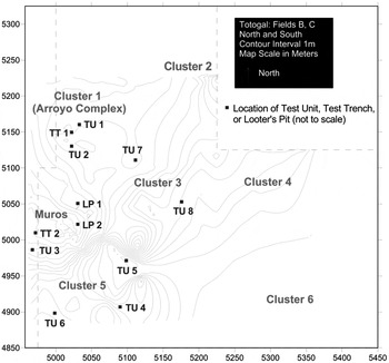
In 2004, I initiated a six-month program of multistaged archaeological survey and stratigraphic excavation at Totogal that aimed to refine the Postclassic chronology for the region and to explore the character of local Aztec-Toztlan interactions. Survey at the site consisted of topographic mapping of the site's terrain and above-ground features, systematic shovel testing of surface deposits, and electromagnetic induction survey in areas of the site that contained above-ground architecture or surface materials suggestive of Aztec-Tuxteco interactions (Venter et al. Reference Venter, Thompson, Reynolds and Waggoner2006). The area surveyed was determined by private property boundaries and the onset of the rainy season (Figure 3). Stoner's 2007 survey of the adjacent Tepango Valley overlapped the eastern edge of the site. The two combined projects indicate that Totogal covered at least 50 ha (Venter Reference Venter2008; Venter and Stoner Reference Venter and Stoner2009).
Eastern survey block at Totogal showing locations of excavation units (TT = Test Trench, TU = Test Unit, LP = Looter Pit Profile) (after Venter Reference Venter2008:Figure 7-1).

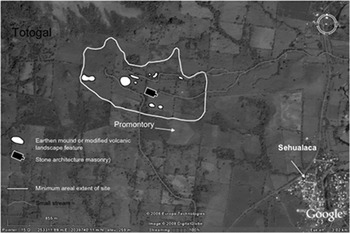
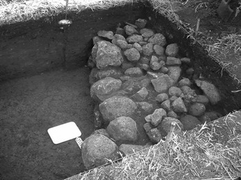
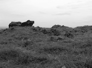
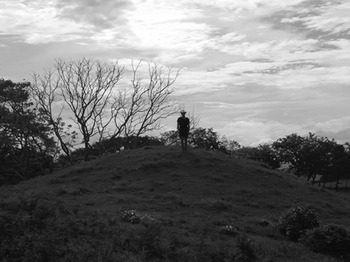
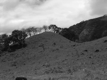
Twenty-six square meters were stratigraphically excavated in four site areas that topographic mapping, shovel testing, and geophysical survey suggested had Aztec-style materials, evidence for possible tribute (cotton thread) production, buried stone architecture, and residential occupations (Figure 3). In addition, the profiles of two large looters' pits were cleaned and recorded. The combined survey and excavation at Totogal revealed several occupied volcanic landscape features (Figure 4) and structures of varying construction styles (for example, rammed earth; dry-laid, fine-grained basalt) (Figures 5–8). The largest Late Postclassic structure at the site would have been the centrally located dry-laid, multi-roomed temple-palace that was initially located during geophysical survey (Venter et al. Reference Venter, Thompson, Reynolds and Waggoner2006). This structure was later topped with a small colonial church (Figure 6).
Architectural features detected at Totogal (after Venter Reference Venter2008:Figure 6-2).

Dry-laid section of Late Postclassic structure at east end of main plaza (after Venter Reference Venter2008:Figure 6-7a).

Masonry architecture at the east end of main plaza (overlays dry-laid structure) (after Venter Reference Venter2008:Figure 7-7a).

Conical mound near west end of main plaza (Venter Reference Venter2008:Figure 6-5).

Volcanic hill near western edge of surveyed area.

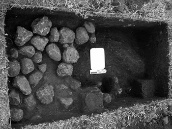
Several low house mounds were also documented on the surface of Totogal. Test excavations on a few of these low mounds revealed stone alignments and/or dry-laid foundation platforms (Figure 9), suggesting that most structures had stone bases topped by walls and roofs made of perishable materials. The differential distribution of burned earth indicates that sometimes these walls were covered with mud plaster. Comparisons of building styles and artifacts associated with these smaller, less formally constructed buildings and the larger scale, more formally constructed and centrally located ones suggest that the former probably were houses associated with Totogal's nonelite population. Dense artifact concentrations were associated with each of the areas of the site that contained architectural features and modified aspects of the naturally occurring volcanic landscape.
Stone alignment in nonelite Residential Area (Cluster 3, Test Unit 7).

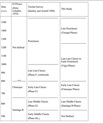
Stratigraphic excavation and radiocarbon dating at Totogal revealed four distinct occupations at the site (Venter Reference Venter2008) (Table 1). The earliest confirmed settlement at Totogal was during the late Middle Classic (a.d. 550–650) Santiago-B phase. During this phase, Totogal was a hamlet-size ceremonial site (Venter Reference Venter2008; Venter and Stoner Reference Venter and Stoner2009).
Classic and Postclassic period chronologies employed in the Tuxtla Mountains (Venter Reference Venter2008:282)

Subsequent occupations continued into the early Late Classic (a.d. 650–800) Chaneque phase and late Late Classic/Early Postclassic (a.d. 800–1250) Vigía phase. Totogal had grown to a small, nucleated village with a residential population by the Chaneque phase, and the site had grown to the size of a large dispersed village by the Vigía phase (Venter and Stoner Reference Venter and Stoner2009). Totogal is the only site in the Tepango Valley that expanded between the Chaneque and Vigía phases, a time when population declines in the region were great (Venter and Stoner Reference Venter and Stoner2009; see also Esquivias Reference Esquivias2003; Killion and Urcid Reference Killion and Urcid2001; Knight Reference Knight1999; Knight and Glascock Reference Knight and Glascock2009; Loughlin Reference Loughlin2004; Pool and Ohnersorgen Reference Pool, Ohnersorgen and Pool2003; Santley and Arnold Reference Santley and Arnold1996). The growth of the site continued into the Late Postclassic (a.d. 1250–1520) Totogal phase, when local population surged and the site became the only center in the Valley. The Totogal phase expansion of the site corresponds with a roughly 500% increase in the density of materials (ceramics and obsidian) per cubic meter of soil in all tested areas and assemblages.
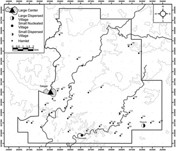
During the Late Postclassic, only one other Tepango-Xoteapan Valley site was relatively sizeable; this was the large nucleated village of Tilzapote, located about 8 km east-southeast of Totogal along the Xoteapan River, a tributary drainage that flows into the Tepango River south of Totogal (Figure 10). Whereas Totogal was the only Chaneque-to-Vigía phase site in the Tepango valley to grow at a time when all other sites declined, Totogal and Tilzapote were the only sites to grow from the Vigía-to-Totogal phase. Totogal's growth, however, was much more pronounced. Valley population also seems to have clustered around the two settlements during the Late Postclassic period, indicating that the two sites may have been competitors in the wake of massive demographic changes and imperial expansion (Venter and Stoner Reference Venter and Stoner2009). Adding support for this suggestion is the apparent abandonment of settlements between the two population clusters, with the Totogal cluster focused on the southern slopes of Cerro el Vigía and the adjacent Tepango River margins, and the Tilzapote cluster focused on the Xoteapan drainage (Venter Reference Venter2008; Venter and Stoner Reference Venter and Stoner2009; see also Kruszczynski Reference Kruszczynski2001; Stoner Reference Stoner2011).
Late Postclassic settlement in the Tepango Valley (after Venter and Stoner Reference Venter and Stoner2009:Figure 4).

AZTEC-PROVINCIAL INTERACTIONS
Berdan (2003), Berdan and Smith (Reference Berdan, Smith, Berdan, Blanton, Boone, Hodge, Smith and Umberger1996), Hicks (Reference Hicks, Brumfiel and Fox1994), Pollard and Smith (Reference Pollard, Smith, Smith and Berdan2003), Silverstein (Reference Silverstein2001), Smith and Berdan (Reference Smith and Berdan1992), and Umberger and Klein (Reference Umberger, Klein and Rice1993) have all discussed imperial strategies employed by the Aztecs. Studies by Curet et al. (Reference Curet, Stark and Zarate1994), Garraty and Stark (Reference Garraty and Stark2002), Ohnersorgen (Reference Ohnersorgen2006), Ohnersorgen and Venter (Reference Ohnersorgen, Venter and Deborah2012), Skoglund et al. (Reference Skoglund, Stark, Neff and Glascock2006), Stark (Reference Stark1990), Stark and Chance (Reference Stark, Chance and Smith2011), Umberger (Reference Umberger, Berdan, Blanton, Boone, Hodge, Smith and Umberger1996), and Venter (Reference Venter2008) are more specific to the Gulf lowlands as well as the material correlates of the Aztec and local strategies that were employed there.
Imperial and Provincial Strategies
Strategies that imperial agents employed during expansion were meant to facilitate the collection of luxury tribute for a growing elite class, to protect external borders, and to extend commercial networks that could otherwise integrate Aztec nodes with areas beyond the empire's territorial limits (Berdan and Smith Reference Berdan, Smith, Berdan, Blanton, Boone, Hodge, Smith and Umberger1996). Other strategies were intertwined and directed toward the sometimes direct and at other times indirect administration of those politico-economic relationships and commercial exchange networks by allied elites (Berdan and Smith Reference Berdan, Smith, Berdan, Blanton, Boone, Hodge, Smith and Umberger1996). As Ohnersorgen (Reference Ohnersorgen2006) has noted, the degree of Aztec interference in particular provinces varied in a way similar to the mosaic pattern documented for the Wari empire of the western Andes (Schreiber Reference Schreiber1992). Berdan (2003), Garraty and Ohnersorgen (Reference Garraty, Ohnersorgen, Bowser and Zedeño2009); Garraty and Stark (Reference Garraty and Stark2002); Ohnersorgen and Venter (Reference Ohnersorgen, Venter and Deborah2012), Silverstein (Reference Silverstein2001), Smith and Montiel (Reference Smith and Montiel2001), Venter (Reference Venter2008), and Venter and Stoner (Reference Venter and Stoner2009) have similarly noted that considerable variability in imperial control existed within Aztec-provincial hierarchies that resulted from different evaluation of costs and benefits of expenditures and cooperation, particular local historical trajectories, the complexity of preexisting local infrastructure, and the directness of imperial interactions. Impinging factors also included the degree of engagement by groups or individuals in the frontier, and the duration of imperial interest in the region.
Strategies used by groups living in areas eventually targeted for imperial expansion may have included bolstering, resistance, emulation, and exodus (Skoglund et al. Reference Skoglund, Stark, Neff and Glascock2006; Stark Reference Stark1990). More recently, Chance and Stark (Reference Chance and Stark2007; see also Stark and Chance Reference Stark, Chance and Smith2011) have added complicity, assimilation, appropriation, and information control. Of these proposed alternatives, bolstering and resistance are the most dichotomous and, in my view, represent umbrella strategies that are similar to the strategies Paynter (Reference Paynter, Green and Perlman1985) described for “development” and “dependency” elites. An important nuance of Paynter's development elites is that they may improve, or bolster, their status by spearheading resistance movements. The strategies proposed by Stark and colleagues are not exclusive to elites.
Several of the alternative strategies that Skoglund et al. (Reference Skoglund, Stark, Neff and Glascock2006) and Stark and Chance (Reference Stark, Chance and Smith2011) have proposed can represent ways of bolstering group status or resisting incorporation. Exodus is most certainly a form of resistance but one in which groups elect not to engage the expanding state. Similarly, information control is a strategy that groups may use in order to further their bolstering or resistance agendas. The same can be argued for appropriation, emulation, and complicity. In the case of the latter, provincial groups, as a form of resistance, may have rejected political and symbolic affiliations with the empire but perceived local economic gain as a way of exploiting the foreigners for their own benefit (Stark and Chance Reference Stark, Chance and Smith2011).
I propose a strategy of mediation, whereby elites attempting to maintain positions of authority at home, but not wanting to be supplanted by competitors more friendly to Aztec expansion, negotiated compromises between imperial agents and local nonelites (Venter Reference Venter2008). It is intermediate between positions of bolstering and resistance (or dependency and development [Paynter 1985]). Mediation has commonalities with the other proposed strategies as well because they represent the different ways groups may bolster or resist expansion, and there is considerable overlap between strategies of bolstering, resistance, and mediation.
Ethnographic and historic geographical studies of boundary region dynamics (for example, Weber and Rausch [Reference Weber, Rausch, Weber and Rausch1994]) suggest that the strategy of mediation is a more nuanced and expected reaction by elites living in core-distant imperial or colonial frontier regions than bolstering or resistance alone, which would have potentially alienated existing constituencies in favor of imperial newcomers (see Schortman et al. [2001] for similar boundary strategies in Honduras). The distant location of frontier communities would have been one of the most important factors permitting this compromise position, even though, ultimately, imperial armies could have conceivably put down recalcitrant settlements (for example, at Cuetlaxtlan [Ohnersorgen 2006]). Unlike bolstering and resistance (Skoglund et al. Reference Skoglund, Stark, Neff and Glascock2006), which would have polarized the imperial-local relationship, a strategy of mediation would have side-stepped many of the potential pitfalls of either of these two strategies used in isolation, and that would have aggravated an already contested socio-political environment. The provincial strategy of bolstering may have had better success in places closer to provincial capitals or the Basin of Mexico, but at the empire's distant eastern edge, the local leaders would have still needed to contend with the realities of governance. Their own political futures may have been jeopardized by allying too whole-heartedly with the Aztecs. Mediation should not be viewed as a third umbrella strategy, but rather as another point along a continuum of reactions between the two poles that could have been realized using several of the other alternatives proposed by Stark and Chance (Reference Stark, Chance and Smith2011; see also Chance and Stark [2007]).
Material Manifestations of Aztec-Local Strategies
The archaeological trends, materials, and styles observed throughout the Aztec empire's outer provinces include a decline in the standard of living combined with an increase in tribute production; increased evidence for feasting associated with elite alliance strategies; imperial-style temples and components (for example, tenons); sculpture-in-the-round; serving vessels (for example, Aztec III Black-on-Orange) and ritual vessels (Texcoco Molded censers); temple models; and particular styles of flat, mold-made figurines (Smith and Berdan Reference Smith and Berdan1992; Smith et al. Reference Smith, Wharton, Olson and Bray2003; Umberger Reference Umberger, Berdan, Blanton, Boone, Hodge, Smith and Umberger1996). Some of these trends or materials and styles have been identified at most of the Late Postclassic period archaeological sites within the ethnohistorically defined Aztec provinces that have been subjected to study.
Reflecting the variability in imperial strategies, local (frontier region) strategies (including degree of resistance and imperial push-back), historical trajectories, and other factors introduced above, the quantity and diversity of imperial symbols have often been interpreted to directly correspond with the overall style of imperialism imposed in a particular location (Ohnersorgen Reference Ohnersorgen2006). For example, the presence of all of the imperial-style symbols at a site (for example, Cotaxtla) has been regarded as a fairly direct (territorial [D'Altroy Reference D'Altroy1992; Luttwak 1979]) form of imperialism (Ohnersorgen Reference Ohnersorgen2006). Where a select few symbols occur, especially when those materials are portable objects used in public displays (for example, fancy pottery) and not permanent architecture, the form of imperialism has been inferred to be more indirect (hegemonic) (Skoglund et al. Reference Skoglund, Stark, Neff and Glascock2006; Hassig Reference Hassig1985).
Excluding Totogal's stone monuments, the contexts of which are questionable, the only definitive Aztec symbols recovered from the site are Texcoco Molded censers. The morphological attributes of Texcoco Molded censers have been described by Smith (Reference Smith and Plunket2002:100). These characteristics include raised bars and dots, cut-out triangles, and long, hollow handles with adornments. At Totogal, the recovery of molds indicates that some of these censers were locally produced; their pastes also contain locally available quartz and feldspar sand and/or volcanic ash tempers (Venter Reference Venter2008).
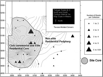
While constituting a relatively minor presence at the site, Texcoco Molded censers (n = 65; 32 from excavations, 33 [including two mold fragments] from shovel tests) are found in greater number at Totogal than at sites that were provincial capitals and closer to the Basin of Mexico (for example, Cotaxtla [Ohnersorgen 2006]). They are also more frequent than at sites in the hinterlands of those capitals (for example, the Cotaxtla Basin [Daneels 1995], Callejón del Horno [Garraty and Stark Reference Garraty and Stark2002; Skoglund et al. 2006], the Maltrata Valley [Lira López Reference Lira López2010], the lower Papaloapan (Jiménez Lara Reference Jiménez Lara2001:11–32), the eastern Lower Papaloapan Basin around El Mesón [Loughlin, personal communication 2010], the Tepango Valley (Stoner Reference Stoner2011; Venter and Stoner 2009], and Agaltepec in Catemaco [Arnold and Venter 2004]). These censers also occur in greater proportion than some domestic contexts at Yautepec, a provincial center just outside of the Basin of Mexico (Smith Reference Smith, Smith and Berdan2003:Table 3). At Totogal, these censers occur most frequently within the civic-ceremonial and elite residential core (Figure 11), where they were found with Totogal Engraved vessels. Both categories of vessels occur in higher-than-expected frequencies in the site core compared to the nonelite residential periphery (Totogal Engraved serving vessels, X 2 = 10.513, df = 1, p < .001 [Venter Reference Venter2008:Table 10-33]; Texcoco Molded imperial-style censers, X 2 = 39.1, df = 2, p < .001 [Venter Reference Venter2008:Tables 10-30, 10-35]).
Distribution of Texcoco-Molded censers at Totogal (shovel test contexts only).

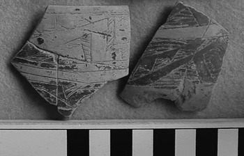
Totogal Engraved ceramics have Fine Orange pastes and are characterized by step frets, avian-serpent elements, and repeating series of filled triangles that are usually arranged diagonally and etched into wide, black-painted panels, covering the circumference of brown-slipped vessels (Figure 12). Totogal Engraved and other similarly etched Gulf lowland vessels likely represent local expressions of the Late Postclassic International Style (Boone and Smith Reference Boone, Smith, Smith and Berdan2003; Masson Reference Masson, Smith and Berdan2003). These ceramics are similar to Choluteca Lisa Esgrafiada (Suárez Cruz Reference Suárez Cruz1995) and Tres Picos-II Esgrafiado (Medellín Zenil Reference Medellín Zenil1960), which have been recovered from Late Postclassic contexts at Cholula and throughout north-central Veracruz. They are rare in south-central Veracruz, however (Daneels Reference Daneels1995; Stark Reference Stark1995). Totogal Engraved and similar Late Postclassic Mesoamerican Gulf lowland ceramics may have been derived from Early Postclassic ceramic traditions that were important to the spread of an elite-centered, Quetzalcoatl-inspired culture throughout Mesoamerica (Rice Reference Rice1983; Ringle et al. Reference Ringle, Negrón and Bey1998).
Motifs characteristic of Totogal engraved serving vessels (after Venter Reference Venter2008:Figure 9-2b).

The association of both types of ceramic objects with civic-ceremonial and elite residential parts of the site suggests that elites hosted ceremonies that included the ritual burning of incense and feasting. Despite their concentration in these areas of the site, both Texcoco Molded censers and Totogal Engraved serving vessels are also found in residential contexts associated with nonelite members of society, though in much lower frequencies. These symbols are also found throughout the Tepango Valley (Venter and Stoner Reference Venter and Stoner2009), as well as at Isla Agaltepec in Lake Catemaco (Arnold and Venter Reference Arnold and Venter2004), though Texcoco Molded censers have a much more restricted distribution than serving vessels. Loughlin's regional survey in the Lerdo-Cabada region near El Mesón yielded only one specimen each of these ceramic types (Loughlin, personal communication 2004).
Several other aspects of the spatial distribution of Totogal's ceramic assemblage are consistent with the performance of feasts and other rituals in the site's civic-ceremonial core. When compared, higher-than-expected frequencies of ritual and serving vessels are represented in contexts with civic-ceremonial or elite residential architecture (X 2 = 39.1, df = 2, p < .001) (Venter Reference Venter2008:Table 10-30), and the mean diameters of plates from these contexts is greater than in other parts of the site (t = 1.92, df = 28, p < .05) (Venter Reference Venter2008:Table 10-31).
In the Arroyo Complex at Totogal, a possible off-mound midden containing some of the site's largest assemblages of central highland products and styles was identified (Venter Reference Venter2008). This latter context also yielded the only carbonized corn observed during excavations and most of the recovered faunal remains.
At Totogal, the evidence of ceremonialism is most concentrated in the civic-ceremonial and elite-residential core. However, that the nonelite segment of the Totogal population also was engaged in, and to some degree approved of, incorporation into the Aztec empire is suggested by the presence of all of these previously mentioned items in domestic contexts beyond the site's center and throughout the Tepango Valley (Kruszczynski Reference Kruszczynski2001; Stoner Reference Stoner2007; Venter and Stoner Reference Venter and Stoner2009).
Because of this distribution of censers and engraved serving vessels, I suggest that the rituals and feasting hosted by Totogal's elites were part of a strategy of mediation meant to promote solidarity and acquiescence to imperial requirements of tribute payment (Venter Reference Venter2008). The use of imperial-style censers by a wide audience, along with the serving of food in vessels associated with local elites, would have helped solidify bonds between local nonelites, local elites, and imperial agents at Totogal that eventually secured the seemingly peaceful payment of tribute to the Aztecs that is described in the Relación de Tustla.
The promotion of Aztec economic strategies (tribute collection) through the sponsorship of public ceremonies might have been furthered by improved access to prized green obsidian. In addition to ritual censers and fancy serving vessels, Late Postclassic civic-ceremonial and/or elite-residential contexts at Totogal also exhibit the highest frequencies of green obsidian from the Pachuca, Hidalgo, source. The representation of this material in the site's obsidian assemblage increased from 12% to 42% in stratified deposits dating from the Vigía to the Totogal phase (Venter Reference Venter2008:Table 11-2). Green obsidian is not, however, directly associated with Aztec imperialism in the provinces, as it is found in areas that were autonomous (for example, Conquest period occupations in the vicinity of Villa del Espiritu Santo in Coatzacoalcos [Arellanos Melgarejo and Beauregard García Reference Arellanos Melgarejo and García2001]). Nevertheless, the Pachuca source was in an Aztec-controlled province, and there were organizational changes in exploitation and production during the transition from the Early to Late Postclassic period that were probably associated with direct Aztec involvement (Pastrana and Domínguez Reference Pastrana and Domínguez2009). One particular change that has the potential to reflect this archaeologically is the reduced size of finished products compared to preforms (Pastrana and Domínguez Reference Pastrana and Domínguez2009; see also Heller and Stark Reference Heller and Stark1998). While production indicators and finished tools were recovered from Totogal, the Pachuca assemblage includes few cores—and no preforms. Reduced size of finished products over time may be another way to measure Aztec involvement in the acquisition of green obsidian, but the low frequency of Early Postclassic obsidian from Totogal would make that a spurious comparison.
A NEW MODEL OF FRONTIER INTERACTION: RITUAL CERAMICS AND THE NEGOTIATION OF IMPERIALISM
Schortman et al. (Reference Schortman, Urban and Ausec2001) suggest that one of the best ways to negotiate competing group interests is through public and ritual use of decorated vessels and other paraphernalia. The forms and decorative attributes of these vessels are particularly well-suited to signaling the types of situational identities that we would expect in frontier negotiations (Gosselain Reference Gosselain2000; see also DeBoer Reference DeBoer, Conkey and Hastorf1990; Pool and Britt Reference Pool and Britt2000). At Totogal, Texcoco Molded censers might have invoked Aztec associations, and Totogal Engraved serving vessels might have represented the local manifestation of international affiliations fostered by Tuxteco elites. It was perhaps the participation of Totogal's leaders in broader networks of elite alliance and exchange that facilitated the inroads made by Aztec agents.
Brumfiel (Reference Brumfiel1987) has argued that the presence of imperial-style ceramic types in the provinces is not necessarily a barometer of wealth, but an expression of social and political relationships. But we should not expect that all inhabitants of every province that adopted imperial-style objects for use in rituals and feasting interpreted them uniformly. Nevertheless, meanings associated with Texcoco Molded censers likely suffered little reinterpretation for the following reasons: (1) they were already used in a variety of public (state) and private (household) contexts in the central highlands; (2) their physical performance characteristics were suited to burning incense and little else; and, (3) there were similarities in language and religious practices among Aztecs and Nahuat-speaking populations in Toztlan that may have fostered the cohesion that was manipulated by Totogal's elites (Foster Reference Foster1943; Paso y Troncoso Reference Paso y Troncoso1905; Umberger Reference Umberger, Berdan, Blanton, Boone, Hodge, Smith and Umberger1996).
The symbolic messages encoded on Totogal Engraved serving vessels and Texcoco Molded censers were especially amenable to the turbulent frontier situations where local elites may have needed to pivot between imperial and local interests and play identity politics in the sense that they had to create cohesion (between Aztecs and local nonelites) where little or none may have existed previously (Bray Reference Bray and Bray2003; Dietler Reference Dietler and Bray2003; Rosenswig Reference Rosenswig2007; Schortman et al. Reference Schortman, Urban and Ausec2001). In the process of striving for group solidarity, elites may have negotiated measured capitulation to foreign control in exchange for benefits conferred by imperial incorporation. Benefits included being invited to ceremonies and improved access to highland exotics such as green obsidian. Within Totogal, the toll of tribute payments appears to have been particularly low (very few spindle whorls were found and no apparent decline in the standard of living was detected [Venter 2008]), signaling that the burden may have been placed on other settlements in the region (those Late Postclassic sites where no Texcoco Molded censers were recovered [Venter and Stoner 2009]). The tribute burden is difficult to determine, however, based on the current understanding of Late Postclassic settlement in the region. Ethnohistoric accounts suggest that another benefit of imperial incorporation may have included support in conflicts with neighboring Coatzacoalcos [Carrasco Reference Carrasco1999]). The indicators of political cohesion, however, included imperial-style ceramics (Brumfiel Reference Brumfiel1987). These are relationships that need additional testing in the southern Gulf lowlands.
What is key about the adoption of imperial-style censers throughout Totogal is that these are the only confirmed in situ imperial-style materials found at the site. Likewise, only Texcoco Molded censers have thus far been recovered from other Late Postclassic sites in the Tuxtlas (for example, Tilzapote and Agaltepec). This contrasts with the nearby Mixtequilla and Cotaxtla basin, where Texcoco Molded censers were used, as well as the more mundane Aztec III Black-on-Orange vessels, flat, mold-made and temple model figurines, and other imperial styles. Archaeologists working at Late Postclassic sites in those regions have interpreted these censers as reflecting the workings of social and political factors and the distribution of Aztec III Black-on-Orange vessels as relating more to economic motives (Curet et al. Reference Curet, Stark and Zarate1994; Garraty and Stark Reference Garraty and Stark2002; Ohnersorgen 2001; Smith 1990). Totogal's elite's selection of only Texcoco Molded censers reinforces the notion that they used these objects to communicate social and political relationships and not solely economic ones. Elsewhere in the Tuxtlas, these censers may have served to create cohesion between allied elites, but their scarcity at other regional sites, like those near El Mesón (Louglin, personal communication 2004), suggests that they were not similarly adopted by all sectors of society.
In general, the mediating role that elites at Totogal are suggested to have played was consistent with a generally hegemonic imperial style of administration, where alliance between the empire and particular frontier elite groups was important (Berdan et al. Reference Berdan, Blanton, Boone, Hodge, Smith and Umberger1996; D'Altroy Reference D'Altroy1992; Hassig Reference Hassig1985; Luttwak Reference Luttwak1976). We can arrive at a better appreciation of how agents navigated larger scale processes such as imperialism, social interaction, and style transmission by examining the local manipulation of ceramic styles. The current evidence suggests that at Totogal, elites in this frontier region may have employed imperial and Tuxteco-style ceramics in their attempts to find compromise between Aztec and local interests. These particular wares would have been important to the negotiation of the face-to-face interactions between the regional imperial presence and sectors of the Tuxteco populace, and to achieve a mutually beneficial arrangement.
CONCLUSIONS
Before this study, only ethnohistorical data had been used to infer the level of involvement of the Aztec empire in the eastern Tochtepec province. Toztlan's misplacement erroneously shifted the imperial boundary to the west, where it was confined to the course of the Papaloapan River (Berdan 1996). Though more recent estimates of Toztlan's location have led to the inclusion of the Tuxtla Mountains, these studies were either solely based on documentary evidence (Carrasco Reference Carrasco1999), or they were unable to identify the archaeological correlates of the period and imperial-local dynamics (Esquivias Reference Esquivias2003; Killion and Urcid Reference Killion and Urcid2001; Santley and Arnold Reference Santley and Arnold1996).
The archaeological study of Aztec interactions with Toztlan is based on data from very few sites, but they nonetheless indicate that a limited range of imperial symbols was adopted locally and used in a variety of public and private, and elite and nonelite contexts. This use of Aztec religious imagery, which was perhaps adopted to accompany ethnohistorically documented Huitzilopochtli worship (Paso y Troncoso Reference Paso y Troncoso1905) by Nahuat groups, is not something that should be expected if elites had adopted strategies meant to ally themselves with the empire at the expense of other local groups or if they had adopted strategies of resistance. If the latter had been the approach of choice, then we should not see the widespread use of this overtly imperial religious symbol. If local groups had merely been smitten by the Aztecs and had attempted to emulate the accouterments associated with a powerful foreign presence, as was so common throughout Mesoamerican prehistory (Fowler Reference Fowler1989), then we should expect similar symbols to have been adopted both within the imperial provinces and beyond (for example, in neighboring, independent Coatzacoalcos). No studies located within the territory of that autonomous polity, however, have reported these or other imperial ceramics or styles (Arellanos Melgarejo and Beauregard García 2001; Coe and Diehl Reference Coe and Diehl1980; Esquivias Reference Esquivias2003; Borstein Reference Borstein2005; Symonds et al. Reference Symonds, Cyphers and Lunagómez2002).
Strategies of bolstering and resistance can be viewed as two poles along a continuum of provincial strategies that also included mediation, a more expected response by groups in frontier regions. Bolstering, mediation, and resistance may have been enacted through a number of secondary strategies, including the control of information, emulation, exodus, and complicity (Stark and Chance Reference Stark, Chance and Smith2011). The archaeological evidence described here provides a perspective that is different in its nuances from other areas of the Gulf lowlands that used some of the same imperial symbols in their social and political interactions. These data from Totogal and nearby sites reveal how groups in the Late Postclassic Tuxtlas may have negotiated a changing political landscape within the context of Aztec expansion.
Rather than adopting strategies of bolstering or resistance, elite groups at Totogal apparently forged a different path, perhaps the one of least resistance, which maintained their status at home while simultaneously appeasing some Aztec demands for tribute. Compromises do not appear to have been shouldered by the inhabitants of Totogal or its immediate environs, however. If they had, then we might expect more or better evidence for a rejection of Aztec symbols such as Texcoco Molded censers and the concomitant broadcasting of distinctly local symbols. Instead, the areas furthest from Totogal in the Tepango Valley are the ones with the fewest Aztec symbols, not the nonelite households within the site or others in Totogal's hinterland. Perhaps the most telling is that the best lands for cotton tribute production (the coastal plain near El Mesón to the immediate west of the Tuxtlas) yielded the lowest frequencies of Texcoco Molded censers known for surveyed areas within the limits of colonial Tuxtla (Loughlin Reference Loughlin2004). This was also an area that was intermediate between Toztlan and Tlacotalpan, one of three other communities within Tochtepec that had locally stationed imperial agents (Berdan 1996; Gerhard Reference Gerhard1993; Paso y Troncoso Reference Paso y Troncoso1905).
RESUMEN
Documentos etnohistóricos han sido usados para definir la frontera oriental del imperio azteca o de la Triple Alianza en la costa sur del Golfo mesoamericano con resultados contradictorios. Nuevos datos arqueológicos de la Sierra de los Tuxtlas está empezando a aclarar el carácter de las interacciones locales-aztecas. En esta ocasión sintetizo los datos históricos sobre la expansión azteca y la interacción a través de su frontera oriental y presento las evidencias más concluyente en este momento con las cuales se puede hablar de una presencia azteca en la costa sur del Golfo.
Los datos arqueológicos con los que cuento son fragmentos de incensarios del tipo Texcoco Moldeado conocidos para sitios aztecas en el altiplano central. En el sitio Totogal, el centro más grande del Valle Tepango de la Sierra de los Tuxtlas, este estilo cerámico es el mejor diagnostico de interacciones imperiales y es encontrado en mayor frecuencia que en otros partes de la costa del golfo. Se utilizaron en contextos de élite y comunes en su mayoría asociados con el primero. Se encontró que los habitantes de sitios de la periferia de Totogal los utilizaron en cantidades menores. Estos incensarios fueron encontrados en contextos similares a otras cerámicas muy finas y decoradas llamadas Totogal Esgrafiado. Estas cerámicas tienen diseños de xicalcoliuhqui, triángulos y cabezas de serpientes. Mi hipótesis es que esta cerámica fue usada entre el imperio azteca y Totogal para negociar acuerdos en esta zona fronteriza—acuerdos relacionados al pago de tributos.
ACKNOWLEDGMENTS
The Consejo de Arqueología of the Instituto Nacional de Antropología e Historía (INAH), specifically former president Joaquín García Bárcena and the former director of the Veracruz office, Ing., Daniel Goeritz, authorized this research. INAH archaeologists Maria del Carmen Rodríguez, Ponciano Ortiz, and Jaime Cortés of the INAH Veracruz office were also immensely helpful. I especially appreciate Ponciano's advice concerning my INAH excavation proposal. The staff at the Santiago Tuxtla and Tres Zapotes museums were also a great help making introductions and providing access to facilities. The landowners who kindly permitted our fieldwork were Rogelio Somarriba, Leonardo Ibarra Castellanos, and Honorio Mozo. Xochitl del Alba León Estrada, Nelly Nuñez Rendon, and Sara Luz Rosiles Hernández oversaw excavation crews with the assistance of Marcos Rodriguez and a local crew.
FAMSI (Grant 03045), the National Science Foundation (Dissertation Improvement Grant [BCS-0427511, PI Christopher Pool, Co-PI Marcie Venter]), the Graduate School at the University of Kentucky, the Robert O'Dear Fund (for research in Latin America), and Lambda Alpha (National Collegiate Honors Society for Anthropology) funded fieldwork at Totogal and laboratory analysis of materials collected. Innumerable thanks go to Drs. Christopher A. Pool and Philip J. Arnold III who were instrumental in the advice they offered from the inception of this project through its completion. Nelly Nuñez Rendon graciously edited my Spanish summary, and Drs. Annick Daneels, Neal H. Lopinot, Blanca Maldonado, Victor D. Thompson, and an anonymous reviewer provided helpful comments on earlier drafts. However, the final product is my responsibility alone.