

Time magazine correspondent Richard Lauterbach traveled back home from Shanghai to the US after documenting the Chinese Civil War in 1947. Instead of choosing the most convenient routes over the Pacific Ocean by plane or ship, Lauterbach decided to cross the Eurasian landmass aboard the Trans-Siberian railway. His first stop was Vladivostok in the Soviet Far East. The train journey would offer a down-to-earth view on a country that was recovering from years of devastation. But when setting foot in Vladivostok, Lauterbach was stunned by the daily living realities in this city, which barely saw any military action during the war. Assuming that the Eastern Front would have been spared of the material and social ravage, Lauterbach saw “probably the most unkempt, disorganized Soviet city” throughout his entire trip. Nowhere—not even in crippled places like Stalingrad—did the municipal authorities and citizens neglect the shabby “appearance of their streets and buildings” more than in Vladivostok.Footnote 1
Lauterbach was not a misinformed outsider. Vladivostok was restlessly growing in a conjuncture of social dislocation, reconstruction, monetary reforms, and famine (1946–47). Streams of war refugees, undocumented settlers, and rowdy, de-mobilized Red Army veterans flooded the urban landscape. Everyone outside the elite echelons coped as best they could to survive in the fragile conditions of postwar life. A municipal deputy named Leshetnyi claimed that the lack of firewood and coal led people to “go and steal fuel from a military warehouse, where they were almost shot.” On an inspection tour of communal amenities, Leshetnyi found a housing block “dirty and [the inhabitants] themselves sitting dirty.” When confronting the concierge, the latter sent Leshetnyi home point-blank, telling him to mind his own business.Footnote 2 Even journalists for one of the party's official newspapers and public mouthpieces, Krasnoe Znamia, were fed up with the situation. Krasnoe Znamia berated the lack of consumer goods and demanded less talk and more action by party officials.Footnote 3 Black market trade flourished, and the port city was a hotspot for crime and hooliganism. Nikolai Pegov, the local party secretary at the time, could not but worry about how these “sneaking infections” undermined public order in Vladivostok.Footnote 4
Other people in the municipal government had bigger worries on their minds. Many unanimously agreed that the lack of basic amenities stirred social unrest in a rapidly overpopulating city. People flocking into large urban centers was not so much a new phenomenon, but rather a sharp acceleration of the 1930s migration dynamics across the country. The lack of water supplies became an urgent rallying point for the party and municipal government because it tested Vladivostok's capacities to function.Footnote 5 For some years already, many claimed that water famine, or the extreme lack of fresh water supplies, could strike the city and “starve it to death.”Footnote 6 One periodical published an interview with V.A. Molkovym, a representative of the municipal council for worker deputies, who openly acknowledged the very dire state of water supplies as a major crisis.Footnote 7 Overcrowded, “anti-sanitarian” living quarters that lacked public bathhouses, access to freshwater, and sewer systems were proof of this state of affairs.Footnote 8 Swarming bacteria led to rampant tuberculosis, kidney, and digestive tract disorders, and even higher mortality rates during the post-1945 years.Footnote 9 Bacteria were not the only things obstructing improvements. The situation was worse on the factory floor and in workshops, where the accumulation of “thousands of tons of rocks, rubbish, hubris of metal and coal” impeded industrial progress.Footnote 10 Members of Vladivostok's municipal executive committee (Gorispolkom) urged one city architect, Filatova, to stop “living in her fantasies” and “to return to reality.” They lambasted her and other enterprises for squandering tight budgets or siphoning off materials for housing construction.Footnote 11 Others attacked the party. It had to “stop excesses, [and] save every national penny,” said F. Saiko, the chairman of the regional financial institution PromBank.Footnote 12
The dizzying postwar chaos notwithstanding, where did promises of the future communist city go in postwar professional debates and conversations among Vladivostoktsy (residents of Vladivostok)? Why were technical plans and city models so hard to spot in everyday scenarios of municipal governance, while ethics and the urgent need for water and fuel continuously invoked? Finally, why were the solutions to Vladivostok's crises interpreted differently by a variety of communities? This article sets out to contextualize and answer these questions.
The earliest scholarship on Soviet/socialist urban history has often considered the lack of control over budgets and expertise, the contradictions between social and economic development, and weak governance as typical features of the messy and failed planning of the Soviet era.Footnote 13 During the 1990s and early 2000s, the historiographical discourse on socialist cities shifted its epistemological foundations. Following Michel Foucault's influential lectures and studies on territory, the modern state, and political power, historians reconceived the socialist city as a delimited arena of Stalinist mass and micro politics through the application of statistical, educational, and health sciences, inter alia.Footnote 14 The so-called “speaking Bolshevik” idea, coined by Stephen Kotkin in his magisterial study Magnetic Mountain, provided a major impetus for this course of change.Footnote 15 The total engineering of the “New Soviet Man,” Kotkin argued, was founded on the Bolshevik biopolitical intervention into everyday life, underpinned by an Enlightenment dogma of economic and demographic calculation, and through cultural and linguistic identification games. Likewise, urban planning played a key role in the making of a new subjecthood. Though contested on the ground, the carefully designed factory and household would be the vehicles to thrust urbanites into a future-oriented, anti-capitalist civilization. “The socialist city,” in Kotkin's words, “was not simply a place where an urban population was located, but a device for inculcating a new set of attitudes as well as new kinds of behavior in its urbanized inhabitants—in a word, an instrument for creating socialist people.”Footnote 16
“Speaking Bolshevik” has, without doubt, become a baseline reference for recent urban histories of socialism.Footnote 17 Heather DeHaan, Paul Stronski, Katherine Lebow, and Christine Varga-Harris published vivid and nuanced accounts of how socialist city planning revolved respectively around resistance against Bolshevik tenets in Nizhny-Novgorod, “the making of new Soviet men and women” in Uzbekistan, social class differentiation in Nowa Huta, and mass housing as the realization of communist ideals.Footnote 18 Anthropologist Stephen Collier similarly employed the term “total planning” to indicate how city building (gradostroitel΄stvo) was plugged into “national mechanisms of economic coordination,” while historian Kimberly Zarecor highlighted how “the socialist scaffold” indicated a consciously open-ended planning of an integrated web of components such as industrial and public sector zones.Footnote 19 These studies showed helpfully the interplay between Soviet state building and the sociocultural dynamics of urban planning and city building.
They also reveal, however, the limits of a historiographical approach that promoted thinking of cities as material phenomena emanating from the imposition of and resistance against an (often ill-defined) ideological project. Viewed from this angle, the city offered a spatial laboratory where urban planning could serve subject formation of the Bolshevik biopolitical state. As such, the supremacy of ideology, or at least its negotiated forms, is often accepted as the major force driving urbanization, itself characterized as a totalizing and fixed modernity experiment. Anna Krylova recently contended that particular “Bolshevik values and modes of thought—a socialist episteme of anti-individualism and collectivism,” has been elevated to a timeless, analytical, over-determined lens (“the basic Bolshevik tenets”) to write about the Soviet century.Footnote 20 The strength and appeal of Magnetic Mountain lay in part, according to Krylova, “…in applying the notion of fixed fundamentals as categories of analysis to Soviet realities regardless of the decade, Kotkin and scholars who draw on his work, equate the longue durée of the Soviet modern project with Bolshevism and its system of anti-individualist values.”Footnote 21 This same critique also points to the pitfalls in urban historiography that has treated the city as the outcome of an ideological project while sidelining the agency of space and the environment.Footnote 22 Nature appears only to be mildly resisting, “immutable and enduring, whereas human subjects [stand] at the immediate roots of agency and historical change during the socialist epoch.”Footnote 23
With this in mind, this article proposes a two-fold argument. First, urban histories of socialism cannot be reduced to a single epistemological rubric that explain the evolution of built environments exclusively in reference to the anthropocentric and dichotomous character of the “basic tenets of Bolshevik ideology.” Such an approach ignores the ways in which different historical actors engaged in concurrent and confrontational practices of building postwar Vladivostok, outside the ideological language of the state.Footnote 24 References to urban planning as tools of population management were certainly visible, but only in limited ways and in specific contexts. I am not necessarily arguing for historical, geographic, or cultural relativism, but rather how the (socialist) city emerged each time as a different object of knowledge and management, depending on the community of professionals and residents that was engaged with urbanization.Footnote 25 To put it otherwise, imaginations of and engagements with space, whether built or natural, existed on multiple, contested scales.Footnote 26 Second, water was central in producing not only the management of ecological resources through its associated infrastructures—dams, pipeline distribution, and sewerages—but it also shaped urban planning and the politics of city building and governance as such.Footnote 27 Rather than assuming that water is an isolated and passive matter in an ideologically-constructed and human-driven form of urbanization, creating and maintaining water supplies stood often at the core of municipal governance, the construction of economic and residential areas, and epidemiological control, among others. The state built its inner urban industries and articulated its welfare promises through its engagements with water, while local residents used its lack thereof as an ethical critique of the local state.Footnote 28
Traditional technical experts (architects, engineers, construction foremen) saw the first city plan (1938) as a direct intervention and opportunity to architecturally cleanse Vladivostok of its tsarist past. While claiming the promises of the communist future, however, the first architect-planners could not find a straightforward path to a tabula rasa, materially and socially. The geographical and climactic embeddedness of the city, and the economic legacies of the tsarist past were hard to get rid of. Rivers existed prior to and outside of any state narrative of radical and utopian transformation, actually determining how the planning of Vladivostok was conceived of. On the eve of WWII, the city's leading architect, Evgenii Aleksandrovich Vasil΄ev, duly noted how Vladivostok existed as “a planned object in hard natural conditions.”Footnote 29 Vasil΄ev also found out that their blueprints were subject to other more powerful institutions in an increasingly militarized borderland during the postwar years. These questions and issues are discussed in the first part.
Party members and municipal officials had a different pair of glasses to look at Vladivostok, which is explored in the second part. Population growth pressured them to see the city not primarily as a neatly planned project, but as a restless organism that had to harvest energy from the non-urban hinterland. For them, the sustenance of urban life could not take place without capitalizing on ecological resources (fresh water supplies, coal, and timber) from the regional periphery. A key mission in their view was to turn nature's sources of energy, such as rivers, into mechanisms of municipal governance and productive forces to ensure public hygiene and urban order.Footnote 30 Water became part of the central and local governments’ postwar drive to raise living standards by improving basic consumption supplies.Footnote 31 But we also see in these attempts the common and grand narratives about the Soviet struggle with nature and how its supposed victory was constructed.
Finally, the amassment of influence and resources by the local, industrial behemoths clashed with not only the technical and governance approaches to city building, but also created distrust towards the municipal government among the residents of Vladivostok. The privileged status of industrial and mining enterprises and the military was visible through land distribution and access to water. Many perceived their behavior as arrogant and careless about the social responsibilities of the community in Vladivostok. Residents were constantly reminded of the inequalities and Gorispolkom's failure to counteract them. Why were some people groups living in dirt, while other districts and industries could sit idle or even enjoy higher living standards? Their frustrations were regularly expressed through worker's councils, party committees, and Krasnoe Znamia. Furthermore, it spurned a quick but uncoordinated development of a self-construction movement, whereby residents and smaller institutions started improvising the urban expansion of Vladivostok. This is the focus of the final part of the article.
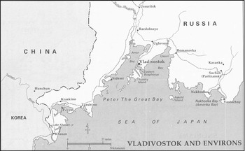
How does socialist urbanization look like at its core? Vladivostok's experiences with water and the making of its infrastructure provides one possible alternative that brings environmental and urban stories of Soviet socialism together.Footnote 32 Not only did water stand central among the concerns of different communities, it effectively shaped ideas, governance, and construction on the ground, sometimes fast and direct, sometimes slow and hard to discern. For this analytical purpose, I employ Anna Tsing's term of assemblage to notice how histories of socialist urbanism were divergent and layered, overlapping and contradictory. As Tsing writes, “patterns of unintentional coordination develop in assemblages. To notice such patterns means watching the interplay of temporal rhythms and scales in the divergent lifeways that gather.”Footnote 33 Instead of locating the center of epistemological gravity in the modernity paradigm, I find it to be intellectually more stimulating to think of socialist urbanism as an “open-ended range of unsettling phenomena” that consists of human and nonhuman forces and expert-and-vernacular knowledge.Footnote 34 (Figure 1)
Vladivostok and Environs. Courtesy of John Stephan/Manoa Mapworks. John Stephan, The Russian Far East, 218.

Professional Visions
By the early 1930s, Bolshevik leaders toned down a decade of eclectic architectural experimentation in seeking to rapidly develop urbanization.Footnote 35 In a plenum titled “On Moscow's urban development and the urban economy [gorodskoe khoziaistvo] in the USSR,” held in June 1931, the Party's Central Committee decided to stimulate the growth of selected urban cores across the nation, including the Russian Far East. Perhaps not entirely coincidentally, the leadership in Moscow sensed that the poorly monitored borders of the Far East, its lack of energy and transportation infrastructure, and sparse population contributed to weak state presence. Furthermore, the Soviet loss of control over the Chinese-Eastern Railway, the barely patrolled fishing zones of the Pacific Ocean, and the territorial encroachment by Japanese troops in Manchuria made it clear that Moscow could not sit idly. In response, the authorities launched a massive resettlement campaign of roughly one million people (mostly Russians and Ukrainians), a crash militarization program that increased border patrol and fortifications, and the ethnic cleansing of mostly Russian Koreans, who were accused of running intelligence operations for imperial Tokyo.Footnote 36
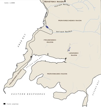
The development of strategically located urban zones was also part of this large-scale transformation. In June 1931, a delegation of planners and architects from Moscow and Leningrad started drafting city plans, launching multiple field site investigations across the region between 1932 and 1934.Footnote 37 Under guidance of D.E. Babenko, employed at Giprogor, the national agency for urban planning, a crew of thirteen people visited Khabarovsk, Aleksandrovsk on Sakhalin island, Vladivostok, and went as far as Petropavlovsk on Kamchatka. When Babenko was transferred to another project, the steering wheel for developing Vladivostok was given to a relatively young man named Evgenii Aleksandrovich Vasil΄ev. Born in 1900 in the town Vladimir east of Moscow, Vasil΄ev belonged to the first and last generation of students to receive formal architectural training at the Higher Art and Technical Studios (VKhUTEMAS) in Moscow. At its peak during the 1920s, VKhUTEMAS was considered the premiere epicenter of revolutionary architectural and artistic thought and innovation. Producing a new design for Vladivostok was Vasil΄ev's first major project; officially dubbed “Great Vladivostok” (Bolshoi Vladivostok), which was completed by 1936 and publicly released in 1938.Footnote 38 (Figure 2)
Simplified representation of the southern tip of the Murav΄ev-Amurskii peninsula. Map created by author (base layer acquired and reproduced with permission from RetroMap.ru.)

Vasil΄ev opened his proposal with ritualistic promises to eliminate the “barbarian, capitalist Russian characteristics” of old Vladivostok. These were, for example, the utter lack of water supplies for the working classes and the segregation of residential areas. Old Vladivostok was a “city of adventurism, tyranny, and land speculation,” where foreign capitalists appropriated the best possible lands for themselves and shirked all responsibilities toward the wider community.Footnote 39 “New Vladivostok” would break the chains of that injustice. In contrast, the re-designed city would provide the bare-minimum conditions for urbanites to lead healthy lives: shortening the distance between work and home; functionally zoning the city into industrial, residential, green, and infrastructural areas; providing needed equal access to services (administrative socioeconomic, cultural); eliminating physical barriers within the urban core and stimulating mobility; and, finally, promoting architectural design.Footnote 40 Predictably, the blueprint included monumental features, such as a large boulevard starting from an amphitheater that provided a view of Golden Horn Bay. It would then gradually lead towards a statue of Lenin (seventy meters in height) towering over Vladivostok.
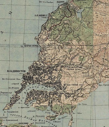
Notwithstanding the idealist conceptions of the future, Vasil΄ev quickly grasped the challenges that the marine environment presented to his project and ambitions. Ironically for a coastal city, Vladivostok was geographically isolated from usable water resources. When the Russian imperial discoverer Nikolai Murav΄ev swiftly incorporated Primor΄e into the Russian empire between 1858 and 1860 at the expense of Qing China and native populations, a cluster of wooden huts on the hilly Murav΄ev-Amurskii peninsula was baptized into Port Vladivostok.Footnote 41 Russkiy Ostrov (Russian Island) lay just off the peninsula's coast with its a carved and hilly contours and many creeks. It served as an ideal location for a military fort and naval base for the Russian imperial navy. Although well positioned from the navy's vantage point, Vladivostok's access to railroads, fuels, and fresh water was all but secured. The subsequent development of the city enjoyed the consistent availability of these supplies. (Figure 3)
City map of Vladivostok, 1936. (Acquired and reproduced with permission from RetroMap.ru.)

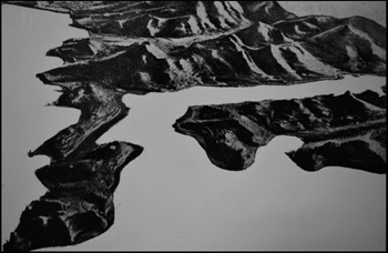
Vladivostok, figuratively known to many as “the socialist outpost” during the Bolshevik era, was the endpoint of days-long journeys aboard the Trans-Siberian Railway. The contrast between this city and the endless flat landscapes seen aboard the train was stark. The imagination of the frontier, as the final destination and the largest city in the Far East, materialized for many when exiting the train station on the waterfront. The station was squeezed on a narrow strip of land between the calmly hovering port waters of the Golden Horn Bay and the towering urban heights of the westerns and northern neighborhoods.Footnote 42 Frequent rough sea winds and rain showers during the monsoon periods slowly chipped away the facades of buildings. This was especially visible for the architecture along the western side of the peninsula where steeper elevations marked its coastline. Precisely because of this setting, the city has not historically developed large mono-industrial zones. Territorial vicissitudes prohibited molding the city's scattered neighborhoods into one or multiple unified urban bodies. Thus sounded the conclusions in the revisions of the 1938 city plan.Footnote 43 Vasil΄ev specifically noted, for example, how the new plan could not unify the dispersed industrial pockets on the southern fringes of the peninsula. Large height differences (from two meters above sea level to 140 meters) hindered building transportation corridors and forced downsizing of housing zones.Footnote 44 Similarly, urban planners in Giprogor found that “the distribution (razmeshchenie) of natural resources, [and] the extreme deficit of convenient space for the industry” posed various tough questions for further industrial development.Footnote 45 (Figure 4)
Landscape Design Model of the Murav΄ev-Amurskii peninsula. Courtesy of GAPK. GAPK, f. 1251, op. 1, d. 348, l. 85.

What dawned upon these urban planners across different institutions was that nature inserted its own presence into these debates. It reconfigured how postwar urban expansion was conceived of.Footnote 46 Vladivostok's opportunities for and barriers to expansion and redesign were curtailed by geological, climactic, and hydrological landscape features, around and onto which urbanization historically had to hitch itself. Experts often debated and coalesced around the hard limits of urban planning posed by nature. Between 1959 and 1961, the Academy of Construction and Architecture of the USSR organized a series of regional conferences on “the scientific conditions for the reconstruction of USSR cities based on the example of Vladivostok.” In this setting, a large body of academics and professionals wanted to highlight how the landscape and geological situation led to a situation where all “questions regarding transportation, water supplies, urban sewerage, and [the city's] heating or gas supplies (teplofikatsii ili gazifikatsii) [were] in fact [not resolved] until the present.”Footnote 47 At the same time, Vasil΄ev revised the 1938 plan and emphasized more strongly that the mindless projection of blueprints in Soviet urban planning was bound to lead to failures.Footnote 48 “A contradiction resides in our practice of [construction] projection, which we all too often forget,” Vasil΄ev wrote in an edited volume on USSR urbanism. The contradiction lay, on the one hand, in the excessive and technical attention for drawing blue prints of buildings during the design stage with the reality, on the other, that those plans never materialized and “[the fact that] the designer almost singlehandedly decides the fate of the city projected in front of him, along with the fate of billions of rubles.”Footnote 49
The problem for Vasil΄ev was not principally about random improvisations on construction sites, incompetent decision-making, or formalist tendencies by some designers. The root of the contradiction, according to Vasil΄ev, lay between “the real existing conditions, the historical developments of every city, and [its] subjective character as the indicators (otsenki) of [those] conditions” and “the art of project-planning.”Footnote 50 Rather than “relying on the help of project-planning agencies,” practicing planners like Vasil΄ev had to accommodate the practical needs and problems of construction workers on the ground. This included paying attention to the history of economic factors in the city's growth, the characteristics of the natural setting and climate, and the historical conditions of the urban past. The solution to the contradiction lay not in abandoning plans, but in “systematically applying a method [based] on theoretical research” in specific places, which would allow organizing urban life. Vasil΄ev saw the main problems in building cities not in the politics surrounding the distribution and production of resources, but in the mindless standardization of city planning. Engaging with Vladivostok taught him that place-based investigations provided the key to better decision-making on the ground. In this holistic approach, these reflections give us a glimpse of the “professional vision” that Vasil΄ev exhibited.
In 1994, the American anthropologist Charles Goodwin noted how professionals in any working environment become part of a community by seeing and interpreting the world in selected ways that might seem incomprehensible to outsiders. Goodwin understood the “professional vision” as “socially organized ways of seeing and understanding events that are answerable to the distinctive interests of a particular social group.”Footnote 51 Architects, municipal deputies, and suburban residents, Goodwin would say, “have the power to legitimately see, constitute, and articulate alternative kinds of events.”Footnote 52 The architectural gaze, present in Vasil΄ev's and others’ descriptions of Vladivostok's development, exemplifies this professional vision. Narrating the past, present, and future of the city revolved around the deep structures of environment and histories of its economic geography. Such professional narratives were not necessarily shared, however, by others holding a stake in Vladivostok's construction and municipal governance, to which we now turn.
Rivers for an Urban Metabolism
Faced with the pressures of the postwar era, the municipal leadership and its bureaucratic apparatus often produced, perceived and eventually responded to urban development in a different way than experts like Vasil΄ev. The former looked at the urban environment as if it were a human body, requiring energy inputs and outputs. Vladivostok's hunger for fresh water supplies, carbon fuels, timber, and grains needed a way in, while its human, construction, and industrial waste needed an exit. To the many sitting on party and city committees debating construction efforts and their finances while communicating the progress with the center of the nation, the focus often lay on how to extract nature's energies like water, coal, and timber from the surrounding hinterlands. Part of the picture that emerges is historiographically familiar. It is a story of a modernist state with an aggressive appetite for complete control over nature, an effort that ultimately proved to be largely broken. The Soviet Union shared this experience to varying degrees with other modernizing nations.Footnote 53 However, the point is not to reiterate the different discourses among party and state apparatchiks who faced certain political and economic pressures, locally and from Moscow. Rather, their debates concerning water supplies reveal how the binary and hierarchical relationship between state and nature, the producing hinterland and the urban consumer, received a new breath of life during this moment in history. Implementing spatial strategies (expanding the electrical grid and railways) and building architectures of extraction (oilrigs, mineral mines, irrigation schemes, and dam projects) all formed part of this evolution on a grander territorial scale.Footnote 54 The idea that rivers and other bodies of water were productive machines that would stimulate economic growth, stymie epidemiological outbreaks, and manage social conditions of the urban population situates itself in this context. Much of this is, then, likewise reflected in Vladivostok's archival record today, which requires us to critically examine the ways in which rivers and other significant bodies of water were projected as playing fields of intervention and uncovered as nature's sites of production.Footnote 55
For many centuries, the Amur River basin provided moving transport, fish and water for consumption, and natural fertilizers for traditional crop cultivation (wheat, millet, barley) for native populations, Cossack, Ukrainian, Russian, Chinese, and Korean settlers.Footnote 56 Rivers embedded human settlements and provided the local populace with its various needs. Before the establishment of Vladivostok in 1860, the rivers’ power in the Amur basin was exploited for self-sufficiency and the accumulated energy did not usually travel beyond the local parameters of the settlements. Irrigation by hand, water mills, and horsepower transformed energy from the river for human metabolism. Even with the arrival of the tsarist autocracy and colonial settlers, including in the early Bolshevik years, collective life around the Amur River basin remained largely untouched by concrete projects to harness rivers into vehicles of empire and industry, unlike in Central Asia.Footnote 57
As Vladivostok grew from a desolate outpost to a sizeable port, however, the imagination of Amur River's industrial possibilities set in. Given the absence of nearby rivers with a constant debit, freshwater basins, or deep groundwater reserves, the city could not have thrived within a naturally-embedded river setting. Instead, its water supplies had to be brought from far away. At the beginning of the twentieth century, entrepreneurs, engineers, and a Swedish-Asiatic Company eagerly suggested proposals, but all were soon abandoned due to the lack of government funding. Against this background, ordinary citizens, state ministries, and companies in Vladivostok took care of their personal supplies, often relying on a privately run network of wells that could freeze during the harsh winters. Securing water from its dispersed sources formed a never-ending headache and crucial objective in Vladivostok's history of municipal management.Footnote 58 Tsarist-led initiatives failed to solve the issue, even to the extent that water had to be imported from neighboring Japan in 1911–12. In the meantime, residents had irregular access to water from three sources, whose provision depended on seasonal fluctuations. These were scattered, individual wells (which covered half of the city's demands), three small lakes west of the center (distributed by twelve kilometers of pipelines), and groundwater pumped up by the railway ministry at the mouth of the river Pervaia Rechka (an eight-kilometer stream just outside the northern urban parameters).
Water supplies remained. As G. Balakin, the regional deputy for communal management (kommul΄noe khoziaistvo) wrote, it was the most pressing issue for urban development in Primor΄e from the 1920s onwards.Footnote 59 This required a structural solution. In 1927–28, municipal authorities launched topographic investigations of three rivers: the Vtoraia, Sedanka, and Bogataia, with its originating lake. The goal was to ensure regular and stable access to clean water, instead of depending on local, scattered, and unpredictable sources. Professionals eventually chose Sedanka as the better site for building a so-called gydrouzel΄, a dam with a hydrotechnical network to pump, store, and transport water. Its size mattered: up to 7.5 million cubic meters of water would be stored to avoid acute shortages. But getting the dam proposal off the ground was anything but secured. Recurring barriers such as lax management and bickering among construction companies led to years of delays. The NKVD and the construction enterprise Sedanstroi were eventually tasked with taking up the responsibility to complete the job. Thus, it was only in July 1936 that the Sedanka gydrouzel΄ entered operations, with massive leakage problems and limited supply capacities hinging on the background.Footnote 60 In addition, forty-five kilometers of pipelines, twelve hydrants, and fifty-four tanks were added to the distribution network in Vladivostok by early 1938.Footnote 61
On June 24, 1936, Krasnoe Znamia heroically welcomed the rough completion of the Sedanka system with the headline “For you, USSR.” The bold and large font immediately captured the reader's eye. Two full pages presented an expression of gratitude to the local NKVD leader, Terentii Dmitrievich Deribas; informative pieces by head engineer K. M. Zubrik; a history of water infrastructure in Vladivostok; the celebration of Stakhanovism; testimonies of Sedanstroi workers; and poems that worshipped the magical power of water and Stalin.Footnote 62 Many remarked how Sedanka was a major hallmark in the rapid development of modernity in the USSR. Nowhere was a project in the Russian Far East of this magnitude accomplished, where an “aggressive fight with nature” took place, and where construction proceeded in such risky conditions “as if [workers were] acrobats.” Yet a more profound change took place, to which only K. M. Zubrik keenly alluded.
The procurement of water, a precious natural resource on a barren peninsula, gained an aura of personal comfort and industrial prosperity. More importantly, by organizing them “in a linear fashion, as reproducible units across landscapes that were framed and solved technologically,” rivers attained the character of calculability.Footnote 63 The Sedanka system would now provide abundant water for Vladivostok's urban life. Before the Sedanka system, Vladivostoktsy were personally responsible to physically fetch water from wells, lakes, and public collectors. It surely was a backbreaking chore. During harsh winters, water could freeze and severely limit supplies, as happened in 1911–12. Moreover, that water was not always safe to drink, especially since bacteria and industrial waste dumping were facts of everyday life during the 1930s. K. M. Zubrik remarked how such scenarios would become fleeting images of the past. The creation of an artificial basin, made out of thousands of cubic meters of cement, would store and provide steady supplies. Pumps and tubes would then lead water to a zone where filters and laboratories would clean the resource from “mechanical impurities and bacteria.” Long pipes would serve as water highways to the city, where water would arrive in houses and apartments straight from the tap. The contrasting image between the two modes of procurement was for Zubrik both exciting and promised a new era of urban and regional development. But what if that new era of comfort remained an elusive and inaccessible reality for many?
For decades after the completion of the Sedanka system, which nominally supplied enough water for the city, debates were raging between the Gorispolkom, district councils, and enterprises over access to water. Why? The answer lies partly in the material character of the production and transportation routes of the water source, which produced a particular form of state and municipal governance. Residents also contested this power through the language of social inequality.Footnote 64
The Sedanka system changed the older energy form of water in several ways. It disembedded rivers from their age-old setting. Instead the Soviet state became a guarantor of water provisions for postwar society, and that remains so to this day even if never fully successful. First, the production of water was moved north (outside the city parameters), spatially centralized, and placed into the hands of a single managing institution (the NKVD). The logical explanation that the Sedanka River offered steady supplies was, of course, widely accepted, but it came at the loss of independent access, creating inequality through a faltering distribution network. Soon debates erupted within the Gorispolkom about the fact that the entire peninsula had only one single water supply line.Footnote 65 It was pointed out “entire districts of the city, located on highly elevated hummocks, were sitting without water,” and how “fecal water was infiltrating urban areas.”Footnote 66 This resonated with observations of technical professionals like Vasil΄ev that the geology of the city made it very hard to build a unified pipeline network. Building a water storage network and a pipeline was one thing. It was another thing to bring water to the individual consumer in a city where some districts were territorially flat, others steeply hilly, and others completely cut off from the network. The local administration had to install powerful pumps that could lift the water to higher altitudes, something that remained a work in progress for years.
Second, hierarchies of distribution took effect. In Vladivostok, not all were created equal to benefit from welfare such as clean water supplies. Exacerbated by the events of the Korean War (1950–53), the language of the Cold War and strategic areas turned Vladivostok into the only major military base on the Soviet Pacific coast. In addition, Primorskii Krai Party Secretary Nikolai Pegov recalled how the municipal government hoped to boost metallurgical industries after the discovery of polymetallic ores between 1941 and 1943.Footnote 67 Metallurgical production skyrocketed between 1946–1953, which required huge amounts of water not only for the highly intensive production processes but also to dispose waste.Footnote 68 It was against this background that “landscapes of priorities” became apparent.Footnote 69 While it is unclear how priorities were set up precisely, the Ministry of Defense and the Pacific Fleet, the two most powerful ministries in a militarized borderland, alone took the lion's share of water supplies (40 percent).Footnote 70 Industrial production, especially heavy industries, claimed the second largest part. Private households came last.
Water for personal consumption was, forcefully and hesitantly, downgraded given the politics of scarcity. The regional Statistical Department warned the Gorispolkom that “the average norm of water usage for economic and drinking needs stands at 150 to 160 liters per person per day. At the present moment, factual water supplies in cities amount up to 60 liters, and in some cities, such as Artem, Ussuriysk [formerly Voroshilov] and others, it does not exceed 30 liters.”Footnote 71 Staying clean in Vladivostok probably felt a bit easier than anywhere else in Primor΄e, because other cities were completely lacking supply systems and public bathhouses.Footnote 72 Even when the Sedanka system was expanded, Gorispolkom members bluntly noted that certain districts felt no improvements at all.Footnote 73 (Figure 5)
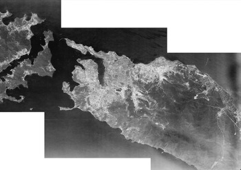
Clipped satellite image of Vladivostok, 1965. By the mid-1960s, the urbanization spree toward the Sovetskii raion in the north was clearly visible and well underway. (Acquired and reproduced with permission from RetroMap.ru.)

The environmental historian William Cronon once noted how historians must see Chicago's urban growth as that of the weaving of “city and country into a single region, economy, and ecology into a single nature.”Footnote 74 Through the standardization of time, space, finance, and technologies, Chicago emerged as the center of capital investment, a logistical hub, and an industrial powerhouse filled with armies of labor that transformed much of the American rural Midwest. Similarly, Vladivostok's municipal authorities noted how the industrial transformation of water provisioning rearranged social relations in the city. Interestingly, while the state initially celebrated the Sedanka system as its achievement of taming nature, the critique of the chronic failures that followed was not situated in the natural unruliness of rivers. Instead, the hotspot of contestation shifted towards the overlapping spheres of water administration, the preferential treatment of industries, and the military. Municipal workers were not exclusively entitled to express their irritation about this situation. People on the ground held that right too, to which I now turn.
The Right to Water and Call to Action
Residents of Vladivostok acutely felt how the aquatic landscape engineering of the 1930s and the politics of water distribution affected their personal lives. Here too, water took central stage in questioning and validating the welfare claims of the socialist state, such as its lofty projections of hygienic standards in a modernizing society. A decade after the Sedanka system started operating, L. Kondrat΄ev was stationed in Vladivostok as a Soviet navy petty officer. He settled with his family in the Lugovoi neighborhood, in the eastern Leninskii raion, just a brisk walk away from the three small lakes that served as water sources years before. The veteran was not happy with his settlement and wrote an open letter “About the furthest street” to Boevaia Vakhta, the Pacific Fleet's periodical. “The years of prewar Vladivostok,” Kondrat΄ev opened his salvo of grievances, “were significantly better than nowadays.”Footnote 75 Why was the party, he asked, only paying attention to the central districts of the city, even after promising to raise the living standards for the entire urban population? “The faraway street, the suburbs,” he continued, “rarely get proper treatment. The master rarely casts his eye here [siuda redko zagliadyvaet khoziaiskii glaz].” Besides lamenting how mud from the nearby hills had been clogging the street for many years, water supplies remained insufficient and even completely unavailable to local residents, according to Kondrat΄ev. We see in this statement how residents attributed the lack of water to the state's active participation in engendering material inequality. More specifically, they framed their relations to the Soviet state as citizens through the environmental and biological necessity of water to fulfil their most basic human needs. Thus, while water existed a priori and physiologically outside the sphere of modern nation-statehood subjectivity, it nonetheless served as a baseline around which residents addressed the shortcomings of their habitats.Footnote 76
In that same newspaper edition, Lieutenant V. Bondarev started a similar appeal by saying that he “didn't love Vladivostok any less than [his] native Rostov.”Footnote 77 Although Bondarev liked to see a grand boulevard in the city filled with green vegetation, why was nobody planting trees on the sopky (a typical Russian noun referring to low-lying hills)? Without tree roots, the soil could easily erode and cause mudslides during stormy weather. Furthermore, none of the dirt could be channeled into the Amur Bay without the help of gutters (and water), Bondarev said. This was a problem for some, not for others. Another navy officer called P. Maslov was living with his family on the northern fringes of the western Fruzenskii district. It was there “more than anywhere else, that I bumped into shortcomings [of urban development].”Footnote 78 Unfinished roadwork and dangerous traffic at night, Maslov demanded, meant that communal amenities had to be extended “to all corners of [our] native town.”
Furthermore, the materiality of water supplies and the politics of distribution produced crises that made residents without access to water vulnerable to epidemic diseases, especially during natural disasters. While provisioning the city, water was also needed to channel dirt and human feces outside the settlement, as Bondarev keenly noted. Thirteen to fifteen large sewage pipes, it was criticized, dumped waste from Vladivostok's households without any chemical treatment directly into bodies of water across the city. Some pipes lead into Amur Bay, off the western densely populated districts. Other pipes released waste dangerously close to a fresh water supply station.Footnote 79
The city thus formed a natural incubator for diseases that could strike its inhabitants, already suffering from a lack of basic facilities and food provisioning. This precarious situation intensified during flood periods and monsoon rainfalls.Footnote 80 Thus, the melting of snow during springtime, monsoon periods around June, and dense typhoons all drastically increased the dearth of river waters. Floods became Primor΄e's greatest natural enemy. They ruined agricultural crops, blocked roads, affected food supplies, caused loss of livestock, and spread diseases such as typhus and cholera.Footnote 81 A. S. Stotsenko, a geographer by training, was a regular consultant to a plethora of party and municipal organs that assessed the risks and responded to these issues. He emphasized that increasing the number and capacity of hydraulic systems in the region was “one of the most important tasks for the Far East” given the risk of natural catastrophes.Footnote 82 Existing sewer systems were out of date and no longer functioning properly: built during the 1900s, they were more than forty years old right after the war. “Since then,” one municipal official added, “no other works on canalization have been executed…. The rest of the city, that is, seventy percent of Vladivostok does not have canalization.”Footnote 83 The existing system was called “primitive,” “dilapidated,” and wastewater could only be drained through a single channel.
By addressing the environmental and infrastructural qualities of Vladivostok, residents placed the professional negligence, corruption, and cronyism of municipal government and behemoth enterprises at the root of their negative experiences. By 1961, of urban state housing “only about 57 percent had running water and plumbing” and “a mere 30 percent had a bath,” as Varga-Harris notes.Footnote 84 Writing about projects in the miner's town of Suchan, west of Vladivostok, N. Gritsaenko stated directly that no plans existed on construction sites. Any schemes that might have existed were usually abandoned as time went on or willfully changed at the whims of local foremen. “Order needs to come to the construction [site] of North Suchan. First and foremost, plans cannot be abandoned.” A systemic approach to city building was necessary, he stated.Footnote 85 In 1952, a large article featured on the front page of Krasnoe Znamia strongly articulated the political and social ills of urbanization. The anonymous journalist first praised how the USSR has been investing and building cities as never before, including in Primor΄e. However, the author then lashed out at how the construction subsidiary of a fishing enterprise was artificially inflating the cost of building materials. “That is a direct fraud of the government!”Footnote 86 Even A. I. Schegolev, the regional party secretary, shot vicious comments about how enterprises idly withheld desperately needed materials. A construction manager named Lazutin was deeply corrupt because he came up with fictional expenses and received salaries for non-existent employees.Footnote 87
In such a climate of distrust, words invoking water turned into material actions. Individuals and entities of all types built their own urban infrastructure, in what we may call a self-construction movement. Specifically, municipal and party leaders frequently invoked the importance of the so-called domoupravleniia (the housing management/administration). These were small assemblies of people in charge for managing housing estates on the level of the neighborhood or even of single apartment blocks.Footnote 88 Mark Smith has explained how the domoupravleniia became catalysts in the postwar era that spurned local citizens to actively insert themselves in response to the housing problems.Footnote 89 Factories, enterprises, hospitals, and everyday people expanded their living and workspaces as they deemed fit. Surprisingly, this practice was not made illegal for many years after the war. Another grey zone emerged during this time, where urbanization incorporated the commanding (but faltering) hand of state construction agencies and the wide leverage given to individual subjects to cope with pressures in the urban sphere. From the highest echelons of rule, party members, municipal officials, and trade unions were instructed not to inhibit these organic developments. A series of state decrees and financial stimuli issued at the height of the war even hoped to give more opportunities to the local residents.Footnote 90 For example, the Council of Ministers decided in 1946 that citizens who wished to build a wooden or a stone house could apply for loans. Credits were provided from eight to twelve thousand rubles and could be paid back within twelve years.Footnote 91 Many felt excitement for the speed and effectiveness with which individual construction took place in Primor΄e. One municipal deputy wrote how individuals constructed sixty percent more housing in square meters in 1956 than “all construction organizations and ministries of our Krai.”Footnote 92 “As we can see,” the deputy explained, “individual housing construction takes a not insignificant part in the turnover rate of housing construction, but it could be probably even bigger if the leaders of individual housing projects received help from the Party and economic organs that they had been promised as the decisions of the Twentieth Congress of the CPSU.”Footnote 93
The haphazard urban expansion also encapsulated conflicts over land-use rights and access to water, however. V. Bolsunovskii, chair of the board of the Dal΄nevostochnii Bank, argued that the ample supplies of credit for individual construction was underused because of the stubborn non-cooperation of the Party and enterprises. Supervisors of local Soviets had “the dishonest habit [nevernaia praktika] of diverting parcels of land under individual construction to the outskirts of settlements, where light, water supplies, and good roads are sometimes lacking…”Footnote 94 Instead, there were call for actions to expand and effectively use the loan programs for individual housing construction. But the authority of the navy and defense ministries interfered again. People also accused the influence of some domoupravleniia of illegally distributing pieces of land and financial support to random individuals and enterprises.Footnote 95 According to central guidelines, certain economic and military ministries could claim ten percent of the entire housing space in Vladivostok, often at the frustration of party members that spoke of a “sharp housing crisis.”Footnote 96
The late historian Moshe Lewin once succinctly mentioned how Soviet urbanization was about “the disappearance of one kind of society and the emergence of another, quite different one.”Footnote 97 The postwar story of the socialist outpost in the Russian Far East suggests how this change was not exclusively predicated on the state's discourses and its intervention into nature and the built environment. Water mediated the changes of the postwar society to which Lewin alludes to. I started from the premise that most socialist urban studies implicitly reified the natural and built environment into lifeless spaces for human intervention. This article challenged this overarching assumption by looking at how ecology conditioned the possibilities of urban infrastructure. Water and its infrastructure formed a fluctuating and crucial site around which urbanization was organized and consequently shaped. It exposed the fault lines between technical experts and the municipal government, between enterprises and ordinary residents, and between the consuming urban core and the producing hinterland. Water cannot be seen as a mere tangible object. It is a cluster that weaves and produces ecological, social, geographic, and political relations, each with different effects and intensities. Contrary to the comfort promises of clean water and electricity, they re-generated new inequalities, incited public hygiene crises, undermined public order, and triggered an urban sprawl in Vladivostok. Much of these realities find their echoes in Henri Lefebvre's remark that space “is not just an achieved order in the built environment, or an ideology, but also an order that is itself always changing from within through the actions and innovations of social agents.”Footnote 98 Soviet space, too, was a dynamic order undergoing radical change, visible in social, economic, and material tensions on the ground. Studying urban and environmental histories together enriches frameworks to study socialist cities whereby nonhuman and seemingly inanimate objects shape social and political life in urban spheres.