Introduction
Significant progress has been made during the past decade with respect to our knowledge of the diversity and taxonomy of the aquatic and limno-terrestrial diatom flora of the Antarctic Region. Diatoms (Bacillariophyta) are one of the most abundant and productive algal groups in Antarctic and sub-Antarctic inland waters and terrestrial environments (Jones Reference Jones1996, Van de Vijver & Beyens Reference Van de Vijver and Beyens1999). However, while the diatom flora in the southern Indian Ocean has been the subject of intensive taxonomic and morphological analyses (Van de Vijver et al. Reference Van de Vijver, Frenot and Beyens2002), the diatom flora in the Maritime Antarctic Region is less studied. Previously published studies from this region report that the diatom floras in the Antarctic ecosystems are composed of only a limited number of taxa (Jones Reference Jones1996, Van de Vijver & Beyens Reference Van de Vijver and Beyens1999, Sabbe et al. Reference Sabbe, Verleyen, Hodgson, Vanhoutte and Vyverman2003). In the past, discrete forms have been lumped together as one single, morphologically variable species while many taxa were force-fitted into European or North American species (Tyler Reference Tyler1996, Sabbe et al. Reference Sabbe, Verleyen, Hodgson, Vanhoutte and Vyverman2003, Van de Vijver et al. Reference Van de Vijver, Gremmen and Beyens2005), indicating that older literature data do not always reflect true diatom diversity. This has lead to incorrect and incomplete interpretations of the biogeography and ecology of the Antarctic diatoms (Sabbe et al. Reference Sabbe, Verleyen, Hodgson, Vanhoutte and Vyverman2003, Van de Vijver et al. Reference Van de Vijver, Gremmen and Beyens2005).
So far, published information on Byers Peninsula is rather limited. Björck et al. (Reference Björck, Håkansson, Zale, Karlén and Jönsson1991, Reference Björck, Håkansson, Olsson, Barnekow and Janssens1993) studied Holocene lake sediments from two lakes on Byers Peninsula, Midge and Åsa lakes, tracking changes in diatoms, spores, tephra and moss remains. Hansson & Håkansson (Reference Hansson and Håkansson1994) studied diatom communities of lakes in the Antarctic Peninsula area, including Livingston Island and King George Island and concluded that the diatom species richness was mainly influenced by both available nutrient availability and latitude. Jones et al. (Reference Jones, Juggins and Ellis-Evans1993) published a detailed ecological study of the diatom flora in the lakes of Byers Peninsula, Livingston Island, and concluded that the diatom species abundance was mostly related to salinity and nutrient gradients. On Hurd Peninsula, another ice-free area on the island, Temniskova-Topalova & Chipev (Reference Temniskova-Topalova and Chipev2001) reported 190 diatom taxa and concluded that the diatom flora of the island consisted of mainly cosmopolitan taxa. This research was continued by Zidarova (Reference Zidarova2008) who described the distribution of algae (including diatoms) in the aquatic and terrestrial habitats on Hurd Peninsula. In 2007, Toro et al. (Reference Toro, Camacho, Rochera, Rico, Bañón, Fernández-Valiente, Marco, Justel, Avendaño, Ariosa, Vincent and Quesada2007) published a complete overview of the limnological characteristics of the freshwater ecosystems on Byers Peninsula and concluded that ‘a major number of cosmopolitan diatom taxa rather than typical Antarctic taxa’ were present.
Recently, a new survey was started to provide a taxonomic and ecological revision of all non-marine diatoms on Livingston Island, based on a more fine-grained taxonomy. This effort has so far resulted in the description of a large number of new species, mainly in the genera Pinnularia, Navicula and Hantzschia (Zidarova et al. Reference Zidarova, van de Vijver, Quesada and de Haan2010, Reference Zidarova, Kopalová and van de Vijver2012, Van de Vijver et al. Reference Van de Vijver, Zidarova, Sterken, Verleyen, de Haan, Vyverman, Hinz and Sabbe2011), showing that the conclusions about the cosmopolitanism of the Livingston Island diatom flora in previous reports were not correct.
The objective of the present paper was therefore to identify the ecological factors that determine the composition and distribution of diatom communities in freshwater habitats on Byers Peninsula using revised taxonomic data.
Methods
Study site
Livingston Island (62°36′S, 60°30′W) is the second largest island of the South Shetland Islands with a total surface area of 974 km2, situated in the southern Atlantic Ocean at c. 150 km WNW of the northernmost tip of the Antarctic Peninsula. The entire archipelago is part of the Maritime Antarctic Region (Chown & Convey Reference Chown and Convey2007), characterized by a less extreme climate than the Antarctic Continent with higher temperatures and precipitation levels. Most of Livingston Island is covered by glaciers, apart from several ice-free areas of which Byers Peninsula, (62°39′S, 61°06′W) forming the western tip of Livingston Island, is the largest (61 km2). The entire peninsula has been designated as an Antarctic Specially Protected Area (ASPA 126). The central part is dominated by a 50–100 m high plateau composed of sedimentary, volcanic and volcaniclastic rocks, bordered on its eastern side by the edge of the Rotch Ice Dome. Cerro Start, in the north-western part of the peninsula, is the highest point (265 m a.s.l.). Permafrost starts at 30 cm and is covered by an active lithosol layer. Björck et al. (Reference Björck, Håkansson, Olsson, Barnekow and Janssens1993) discussed the geological history of the peninsula and concluded that some of the lakes underwent deglaciation c. 5000 years bp. Scattered over the entire peninsula, more than 110 lakes and ponds of variable sizes can be found covering a total surface of 1.5% of the total surface of the ice-free area (Toro et al. Reference Toro, Camacho, Rochera, Rico, Bañón, Fernández-Valiente, Marco, Justel, Avendaño, Ariosa, Vincent and Quesada2007). Streams are usually quite shallow, organized in three hydrographic systems with flow regimes determined by precipitation patterns (Toro et al. Reference Toro, Camacho, Rochera, Rico, Bañón, Fernández-Valiente, Marco, Justel, Avendaño, Ariosa, Vincent and Quesada2007).
The climate is typically maritime with mean summer temperatures ranging from 1–3°C, daily maxima up to 10°C and minima not lower than -10°C. Precipitation is much higher than in Continental Antarctica with mean annual values of 700–1000 mm (Toro et al. Reference Toro, Camacho, Rochera, Rico, Bañón, Fernández-Valiente, Marco, Justel, Avendaño, Ariosa, Vincent and Quesada2007).
The terrestrial vegetation on Byers Peninsula is rather sparse, mainly composed of lichen and moss species and two higher vascular plants (Deschampsia antarctica Desv. and Colobanthus quitensis (Kunth) Bartl.), which form small carpets in the coastal areas. The inland part of Byers Pensinsula is almost unvegetated apart from moss and lichen carpets on wet valley floors and seepage areas. The fauna is restricted to marine birds (penguins, petrels) and mammals (mainly elephant seals (Mirounga leonina (L.))) often forming large colonies on the beaches and lowlands.
More details on the geology, climate, hydrology and vegetation of Byers Peninsula can be found in Björck et al. (Reference Björck, Håkansson, Olsson, Barnekow and Janssens1993) and Toro et al. (Reference Toro, Camacho, Rochera, Rico, Bañón, Fernández-Valiente, Marco, Justel, Avendaño, Ariosa, Vincent and Quesada2007).
Sampling
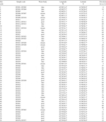
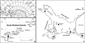
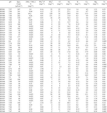
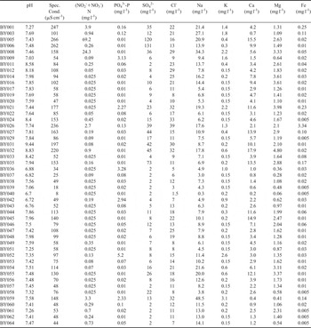
Fieldwork was carried out during the summer of 2009 as part of the Limnopolar Project POL2006-06635. A total of 71 diatom surface samples were collected in January 2009 from 29 lakes, 18 pools (surface area < 100 m2) and eight streams (Table I, Fig. 1). Geographical coordinates of each sampling location were recorded using a Garmin® Map60CSx GPS. For every sample, bottom sediment in the littoral zone was collected in small PVC bottles and fixed with 3% formalin. At 49 sampling sites, water has been collected 20 cm below the surface, filtered in situ and kept frozen until laboratory analysis. Specific conductance and pH were measured in the field using a YSI 556 MPS handheld Multiparameter instrument (YSI Ltd, Hampshire, UK). Frozen water samples were analysed for NO2-+NO3--N, NH4+-N, PO43--P, SO42-, Cl-, Na+, K+, Mg2+, Ca2+, Fe3+ at the Laboratory for Ecosystem Management (University of Antwerp, Belgium). NH4+-N concentration was always below the detection limit (< 0.08 mg l-1) and therefore was not used in the analyses. Table II lists all samples together with their chemical characteristics. To obtain a more complete picture of the diatom diversity of Byers Peninsula, 22 additional samples were taken from the same localities for diatom analysis only, often from different substrates such as floating filamentous algae, stones or microbial mats.
List of studied waterbodies and diatom samples.

a. Location of the South Shetland Islands in the southern hemisphere close to the Antarctic Peninsula, b. Livingston Island within the South Shetland Islands, and c. Byers Peninsula with the location of all sampling sites. Numbers refer to sampling sites listed in Table I.

Water chemistry characteristics of sampling locations.
Slide preparation and diatom identification
Diatom samples were cleaned using a modified method described in Van der Werff (Reference Van der Werff1955). Subsamples were cleaned by adding 37% H2O2 and heating to 80°C for about 1 hour. Oxidation of organic material was completed by addition of KMnO4. Following digestion and centrifugation (10 min at 3700 x g), the resulting cleaned material was diluted with distilled water to avoid excessive concentrations of diatom valves on the slides, dried on microscope cover slips, and mounted in Naphrax®. Samples and slides are stored at the National Botanic Garden of Belgium (Meise, Belgium).
In each sample, 400 diatom valves were identified and enumerated on random transects at x1000 magnification under oil immersion using an Olympus BX51 microscope equipped with Differential Interference Contrast (Nomarski®) optics. After the count, the rest of the slide was scanned for rare species that were not observed during the counting.
Diatom identification was based on the latest taxonomic publications (e.g. Van de Vijver et al. Reference Van de Vijver, Frenot and Beyens2002, Reference Van de Vijver, Mataloni, Stanish and Spaulding2010, Reference Van de Vijver, Zidarova, Sterken, Verleyen, de Haan, Vyverman, Hinz and Sabbe2011, Zidarova et al. Reference Zidarova, van de Vijver, Quesada and de Haan2010, Reference Zidarova, Kopalová and van de Vijver2012, Kopalová et al. Reference Kopalová, Veselá, Elster, Nedbalová, Komárek and van de Vijver2012; and references therein). For several species, identification to species level was not possible due to their unclear taxonomic status. All valves belonging to the genus Gomphonema were grouped under Gomphonema spp. whereas the valves belonging to the Nitzschia perminuta-complex were split into N. perminuta-capitate forms and N. perminuta-non-capitate forms based on the shape of their apices. Further morphological and taxonomic research will be necessary to establish their correct identity.
Data analysis
For a pairwise comparison of the diatom flora of Byers Peninsula with other Antarctic localities (Antarctic Continent, James Ross Island, Iles Crozet), the similarity coefficient of Sørensen (Reference Sørensen1948) was used. To compare the flora with the species composition of the Antarctic Continent, a species list was compiled based on Sabbe et al. (Reference Sabbe, Verleyen, Hodgson, Vanhoutte and Vyverman2003), Ohtsuka et al. (Reference Ohtsuka, Kudoh, Imura and Ohtani2006), Gibson et al. (Reference Gibson, Roberts and van de Vijver2006) and Esposito et al. (Reference Esposito, Spaulding, McKnight, van de Vijver, Kopalová, Luinski, Hall and Whittaker2008). For James Ross Island, the comparison is based on a partly unpublished species list (Kopalová et al. Reference Kopalová, Veselá, Elster, Nedbalová, Komárek and van de Vijver2012, unpublished data). The species list from Iles Crozet in Van de Vijver et al. (Reference Van de Vijver, Frenot and Beyens2002) was used as a proxy for the entire sub-Antarctic Region in the southern Indian Ocean as almost 90% of the diatom flora is shared by all four islands in this subregion (Van de Vijver et al. Reference Van de Vijver, Gremmen and Smith2008).
The geographic distribution of the taxa was based on literature data provided with unambiguous illustrations and/or descriptions (Appendix A). When the identity of a taxon could not be determined with 100% certainty, this was shown using ‘cf.’ or ‘sp.’ and, its distribution was usually listed as unknown (U). Several unidentified species (mainly in the genus Diadesmis, Eunotia, Surirella) are currently under revision and their description as new (Antarctic) species is pending (Kopalová et al. unpublished data, Van de Vijver et al. unpublished data). Their distribution is listed as Maritime Antarctica (MA). For Antarctic species, the geographic distribution was further refined in MA when the species only occurred in the Maritime Antarctic Region. Antarctic taxa with a wider distribution in the entire Antarctic Region are listed as ‘A’.
To determine the extent to which our sampling effort represented the diatom flora in the lakes of Byers Peninsula, we calculated the incidence-based species richness estimator (ICE, Chao et al. Reference Chao, Hwang, Chen and Kuo.2000) and the mean Chao2 richness estimator (Chao Reference Chao1984), using the EstimateS program version 8.2 (Colwell Reference Colwell2009). Shannon-Wiener diversity index (log10-based) and Hill's evenness index were calculated using the statistical package MVSP. All environmental variables except pH were log-transformed since they had skewed distributions.
A hierarchic-agglomerative clustering, based on minimum variance strategy with Squared Euclidean Distance as dissimilarity measure, was used to classify the samples based on the water chemistry data. Principal Components Analysis (PCA), based on a standardized correlation matrix, was used to determine the main directions of variation in the water chemistry dataset.
Constrained ordination techniques were used to elucidate patterns in diatom species composition in relation to measured water chemistry characteristics. All statistical analysis was performed using CANOCO version 4.5 (ter Braak & Smilauer Reference Ter Braak and Smilauer1998). Square-root transformed abundance data were used in the ordinations. Rare taxa (i.e. a taxon not present in at least one sample with a minimum relative abundance of 1%) were removed from the analyses. As an initial detrended correspondence analysis (DCA) revealed a gradient length in standard deviation (SD) units smaller than 2 SD, linear species reponse curves could be expected (ter Braak & Prentice Reference Ter Braak and Prentice1988). We therefore used a linear ordination technique, Redundancy Analysis (RDA). As environmental variables are often correlated, RDA with forward selection and unrestricted Monte Carlo permutation tests (999 permutations, P < 0.05) was used to select a minimal subset of environmental variables that independently and significantly explain the variation in the species data. Groups of significantly correlated (P < 0.05) environmental variables were first identified using a Pearson correlation matrix with Bonferroni-adjusted probabilities. In each group, forward selection was then used to select the minimal number of significant parameters that could explain the largest amount of variation in the species data. The selected variables of each group were then combined together and analysed again by forward selection to obtain a final set of environmental parameters to be used in RDA. Monte Carlo unrestricted permutation tests (999 permutations) were used to test the significance of the constrained ordination axes (ter Braak & Smilauer Reference Ter Braak and Smilauer1998).
Results
Water chemistry
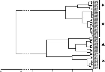
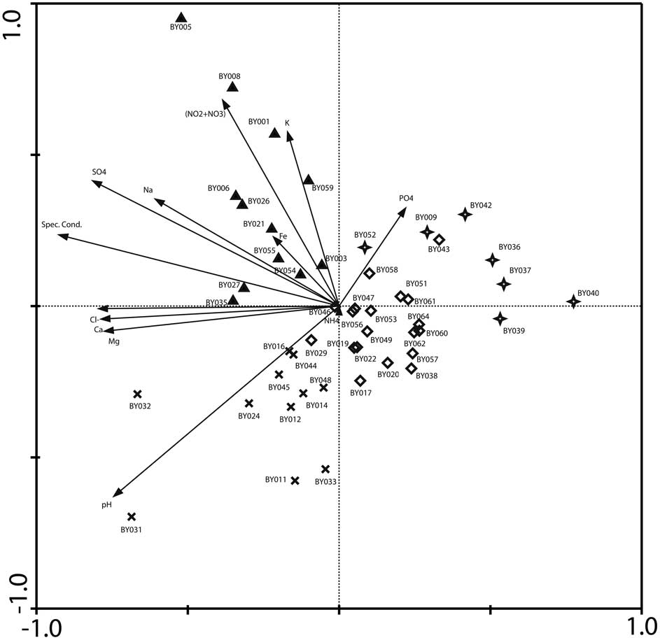
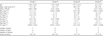
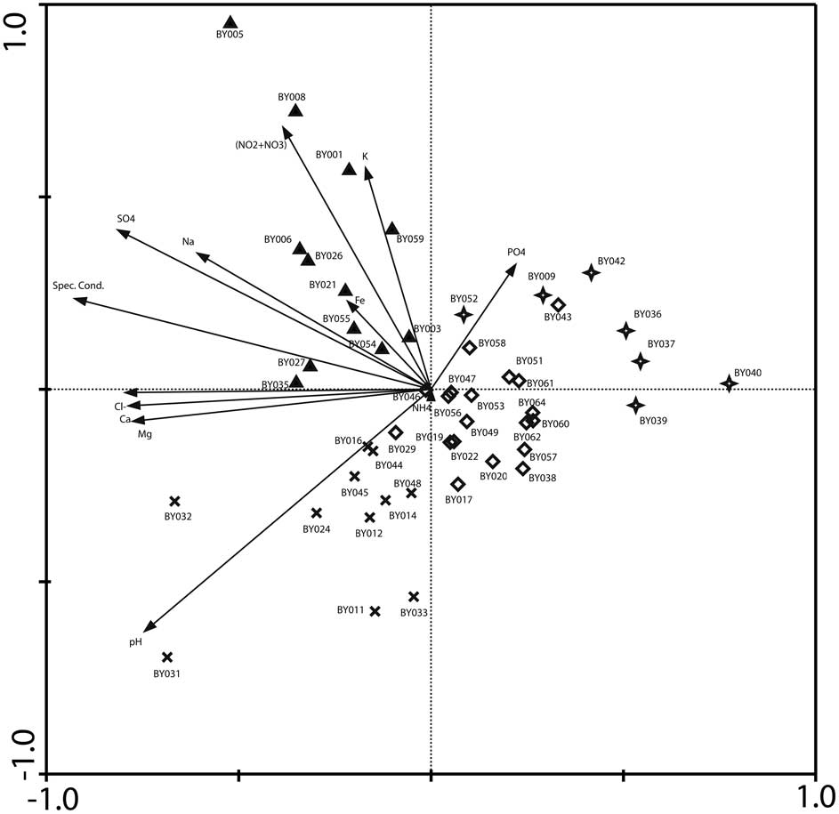
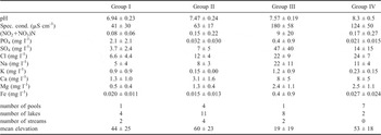
To summarize the major patterns of variation within the chemistry data, cluster analysis and PCA were used. Cluster analysis (Fig. 2) was used to divide the samples into four groups. These groups could be identified on the PCA diagram (Fig. 3) marking the samples with four different symbols. PCA axis 1 accounts for 51.7% of the total variance (λ1 = 0.517) in the dataset. The axis represents a gradient related to salinity (Specific Conductance, Cl-, Ca2+, Mg2+, SO42-, Na+), whereas the second axis accounts for 22.2% of the total variance (λ2 = 0.222) and appears to represent a nutrient gradient. Table III shows the mean parameter values for each group. The first group contains relatively young, recently deglaciated lakes situated close to the Rotch Ice Dome. They are characterized by low specific conductance values (40 ± 30 μS cm-1), an almost circumneutral pH (6.9 ± 0.2), and low nutrient and major ions levels. The higher amount of PO43- is the result of the inclusion of some lakes from the general plateau that have a higher phosphate level (up to 5.2 mg l-1). A second group, related to the first one, contains all larger lakes located on the central plateau (altitude > 50 m). They usually have a higher pH (7.46 ± 0.23), rather low specific conductance values (63 ± 17 μS cm-1) and slightly higher nutrient and cation levels (except PO43-) than the previous group. The third and fourth group have a completely different chemistry. The third group contains coastal lakes with high nutrient (except PO43-), sulphate (47 ± 40) and specific conductance values (179 ± 58 μS cm-1) but with an equal pH compared to group II (7.57 ± 0.19). The fourth group is composed of several smaller, shallow temporary pools. They are characterized by higher pH (8.3 ± 0.5), a moderate specific conductance and higher nutrient and cation values. The different streams in the study do not seem to be restricted to one group but can be found in groups I, II and III with a majority in group II. Four of them are meltwater streams (e.g. BY027, BY029), flowing out of snowfields and feeding the lakes on the higher plateau. Two flow in the coastal region and two are situated close to the Rotch Dome.
Dendrogram showing the results of the cluster analysis of 49 sites based on water chemistry data. Symbols correspond to groups shown in Fig. 3.

A correlation biplot of samples and environmental variables resulting from the Principal Components Analysis of the water chemistry dataset. Symbols indicate sample membership in the groups, identified by the cluster analysis, (stars = young lakes close to the Rotch Ice Dome, diamonds = larger lakes on the plateau, crosses = coastal lakes with high nutrients, pyramids = temporary shallow pools).
Water chemistry characteristics and elevation in sample groups identified by cluster analysis (mean and standard deviation).
Species composition and biogeography
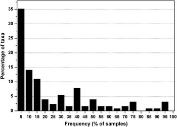
A total of 143 diatom taxa (including species, varieties and forms) belonging to 38 genera were found (Appendix A). Species richness per sample ranged from 5 to 48 (median value 30, average number 28 ± 9). The highest species richness was recorded in samples BY029 (48 taxa), BY009 and BY014 (45 taxa) and BY067 (44 taxa) whereas lowest species richness was found in sample BY050 (5 taxa). Diversity analysis revealed a mean Shannon-Wiener diversity index of 1.02 with an SD of 0.25 and a mean evenness measure of 0.68 ± 0.14. Species relative abundance varied considerably. Fifteen taxa were only found after scanning the slides after counting and seven taxa were found with only one single valve in all counts together (28 400 valves). Sixty-three taxa (almost half of all taxa) together accounted for 1% of all diatoms counted. A large number of species are restricted to only a few samples and very few taxa occur in 50% or more of all samples (Fig. 4).
Frequency distribution of diatom taxa in studied samples (e.g. 5 indicates 1–5% of all samples).

Based on the species richness estimators, it is possible to evaluate how well the sampling effort reflected true diatom species richness. The expected total number of taxa in all samples is 139 (ICE) or 138 (Chao2) for the Byers Peninsula lakes, suggesting that the counting protocol scored about 93% of the total taxa present in the samples overall.
The genera Nitzschia (31.7% of all counted valves), Fragilaria (11.6%) and Psammothidium (10.8%) dominated the counts when considering the frequencies of counted valves. The most species-rich genus was Pinnularia (22 taxa), followed by Luticola (14 taxa), Diadesmis (10 taxa) and Muelleria (10 taxa). The most abundant taxa were Fragilaria capucina (11.5%), Nitzschia perminuta-capitate form (9.7%) N. homburgensis (7.7%), Psammothidium papilio (6.3%) and Gomphonema spp. (5.2%). The ten most abundant taxa accounted for 60.3% of all counted valves; these are indicated in bold in Appendix A.
A large number of unknown taxa, mainly belonging to the genus Pinnularia were found. A taxonomic revision of this genus resulted in seventeen published new taxa (Van de Vijver & Zidarova Reference Van de Vijver and Zidarova2011, Zidarova et al. Reference Zidarova, Kopalová and van de Vijver2012). Several other taxa were only recently described from Livingston Island: Placoneis australis (Zidarova et al. Reference Zidarova, van de Vijver, Mataloni, Kopalová and Nedbalová2009), Hantzschia hyperaustralis, H. acuticapitata, H. confusa, H. incognita (Zidarova et al. Reference Zidarova, van de Vijver, Quesada and de Haan2010) and Navicula dobrinatemniskovae (Van de Vijver et al. Reference Van de Vijver, Zidarova, Sterken, Verleyen, de Haan, Vyverman, Hinz and Sabbe2011).
Almost 56% of all observed species have a restricted Antarctic distribution with a majority of these (78%) confined to the Maritime Antarctic Region. Only 44 taxa (31%) have a cosmopolitan distribution, such as Navicula gregaria, Pinnularia borealis and Mayamaea permitis. A very small proportion of all counted valves (7 taxa) belonged to marine species, probably blown in by wind or sea-spray.
Similarity was fairly high between the diatom floras of the Byers Peninsula and James Ross Island (Sørensen's Index = 0.63) but low between the studied flora and the flora of the sub-Antarctic islands (as represented by Iles Crozet) and the Antarctic Continent (respectively 0.28 and 0.19).
Diatom community analysis
A dataset of 49 samples and 81 diatom taxa was used in the ordinations. All environmental variables related to salinity (specific conductance, SO42-, Na+, Mg2+, Cl-, K+ and Ca2+) were highly correlated. Forward selection in RDA that used only these parameters as constraints, identified specific conductance, SO42-, Ca2+ and Cl- as environmental variables that together significantly explained variation in the diatom data (P < 0.05). In the second RDA, these four parameters and nitrogen (= NO3-+NO2-), PO43-, pH and Fe3+ were used as constraints. The forward selection in this second RDA selected pH, SO42-, Ca2+, Cl-, nitrogen and specific conductance as a minimal set of variables that together significantly explained variation in species data.
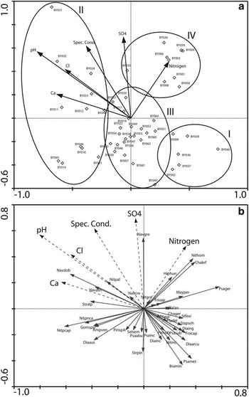
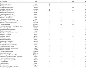
The second RDA constrained to the six selected environmental variables (Fig. 5) explained only a small proportion of the species variance in the samples. The first two axes (λ1 = 0.112, λ2 = 0.054) were highly significant (P = 0.001) but accounted for only 16.6 of the cumulative variance in the diatom data. This is low but typical for noisy datasets with many blank values (Stevenson et al. Reference Stevenson, Juggins, Birks, Anderson, Anderson, Battarbee, Berge, Davis, Flower, Haworth, Jones, Kingston, Kreiser, Line, Munro and Renberg1991). RDA axis 1 is relatively strongly correlated with pH (inter-set correlation = -0.68) and to a lesser extent with Cl- (0.48), separating the lakes sampled close to the Rotch Ice Dome on the right side of the diagram (group I) from the smaller temporary pools on the left side of the diagram (group II). All larger lakes have an intermediate position between these two groups (group III). The second axis is related to SO42- (inter-set correlation 0.50), separating a group of coastal lakes, characterized by higher nitrogen and SO42--levels (group IV). There are marked differences in diatom species composition between the different groups (Table IV, Fig. 5). Only species with a cumulative fit of > 25% in an RDA diagram have been shown in Table IV and Fig. 5. Although some taxa seem to occur in high abundances in almost every group (such as Psammothidium papilio, Fragilaria capucina s.l. or Nitzschia perminuta - capitate form) it is clear that a number of taxa showed a distinct preference for a particular group. Group I is characterized by high frequencies of Brachysira minor, Diadesmis arcuata, Stauroforma exiguiformis, Diadesmis inconspicua and Nitzschia homburgensis, although the latter is shared with group IV. The temporary pools (group II) contain higher numbers of several Navicula taxa, Staurosira alpestris, Nitzschia perminuta - non-capitate form and several other Nitzschia species such as N. gracilis and N. paleacea. Larger lakes (group III) do not seem to have a specific diatom flora since most dominant taxa are also present in high numbers in other groups, although taxa such as Sellaphora seminulum, Psammothidium abundans, and Staurosira pinnata show their highest abundances in this environment. Finally, coastal pools are dominated by Navicula gregaria, Planothidium delicatulum, Chamaepinnularia krookiiformis, Mayamaea permitis and Hippodonta hungarica.
Redundancy Analysis (RDA) correlation biplots. a. Sample and environmental variables biplot. b. Species and environmental variables biplot. The codes of species names are given in Table IV.

List of diatom species with a cumulative fit of > 25% in RDA and their mean relative abundances in the four groups of samples identified by the cluster analyses of water chemistry data (X > 10%, O 5–10%, ° 2–5%,+ < 2%). I to IV represent the different sample groups.

Discussion
Species composition and biogeography
In the first diatom study on diatoms from Byers Peninsula (Jones et al. Reference Jones, Juggins and Ellis-Evans1993) only 52 taxa were listed, of which 14 could not be identified to the species level despite the fact that a comparable amount of lakes and habitat types were sampled. In the present study, a total of 143 taxa was observed. Although part of the observed flora is the same (some nomenclatural changes notwithstanding), several taxa formerly identified as cosmopolitan have now been described as separate species, most of which are endemic to the Antarctic. Examples include Navicula cryptocephala var. veneta (Kütz.) Rabenh. (now split in three new Antarctic species, viz. N. austroshetlandica, N. dobrinatemniskovae and N. cremeri (Van de Vijver et al. Reference Van de Vijver, Zidarova, Sterken, Verleyen, de Haan, Vyverman, Hinz and Sabbe2011)), N. bicephala Hust. (now N. bicephaloides (Van de Vijver et al. Reference Van de Vijver, Zidarova, Sterken, Verleyen, de Haan, Vyverman, Hinz and Sabbe2011)), and Navicula elginensis (Greg.) Ralfs in Pritch. recently described as Placoneis australis (Zidarova et al. Reference Zidarova, van de Vijver, Mataloni, Kopalová and Nedbalová2009). Apart from taxonomic changes, more differences between the two studies can be noted. Several genera are completely missing from Jones et al. (Reference Jones, Juggins and Ellis-Evans1993), such as Hantzschia, Diadesmis, Muelleria and Luticola (the latter three were formerly included in Navicula s.l.), although it is possible that some of these species are included in the species list as unidentified taxa. On the other hand, some taxa are listed that could not be found in the present study such as Achnanthes pinnata Hust. or A. mollis Krasske (although the latter might be the consequence of a misidentification due to its similarity with Psammothidium abundans). These differences in species composition may also be due to differences in the sampling strategy since samples in Jones et al. (Reference Jones, Juggins and Ellis-Evans1993) were taken from the deepest parts of the lakes using a gravity corer whereas in the present study, surface samples were taken from the littoral zone. In Jones et al. (Reference Jones, Juggins and Ellis-Evans1993), no lakes close to the Rotch Dome were sampled. In the present study however, a lot of species have been found in those young lakes which may also partly explain the higher number of taxa found in our study.
Based on these observations, it is not surprising that several diatom studies, even quite recent ones, concluded that the freshwater diatom flora in this part of the world is merely composed of cosmopolitan taxa (Jones Reference Jones1996, Van de Vijver & Beyens Reference Van de Vijver and Beyens1999, Toro et al. Reference Toro, Camacho, Rochera, Rico, Bañón, Fernández-Valiente, Marco, Justel, Avendaño, Ariosa, Vincent and Quesada2007, Vinocur & Maidana Reference Vinocur and Maidana2010) or that no differences could be noted between the different parts of the Antarctic Region (Jones et al. Reference Jones, Juggins and Ellis-Evans1993). However, with almost 56% of the observed taxa being restricted to the Antarctic Region, it is clear that these statements can no longer be accepted. Similarities with the other parts of the Antarctic such as the Antarctic Continent, are quite low, contradicting the presumed cosmopolitanism of the Antarctic diatom flora. The low similarity between the biotas of the Antarctic Peninsula and the Antarctic Continent has been demonstrated earlier for other taxonomic groups such as nematodes (Andrássy Reference Andrássy1998) and free-living mites (Pugh Reference Pugh1993). This led to the establishment of the so-called Gressit-line, separating the biota of the Antarctic Peninsula from that of the Antarctic Continent (Chown & Convey Reference Chown and Convey2007). The diatom flora of James Ross Island is most similar although there is still almost 37% of difference between the two island floras, probably due to the location of James Ross Island in the transition zone between the Maritime Antarctic Region and the Antarctic Continent. Several typical Antarctic Continent taxa such as Luticola gaussii (Heiden) D.G.Mann and Achnanthes taylorensis Kellogg & Kellogg are absent on Byers Peninsula, but present on James Ross Island (Kopalová et al. Reference Kopalová, Veselá, Elster, Nedbalová, Komárek and van de Vijver2012). Lack of taxonomic consistency (following considerable taxonomic revisions in several genera) in previously published studies from other Maritime Antarctic localities make a floristic comparison, however, impossible. Key taxa such as Navicula muticopsis Van Heurck, Hantzschia amphioxys (Ehrenb.) Grunow and Stauroneis anceps Ehrenb. were split up in a large number of Antarctic taxa. It is clear that further taxonomic research, revising not only the diatom flora of these other localities, but also of genera that lack a proper revision such as Gomphonema or Nitzschia, will influence and enhance greatly the biogeographic insights of the Maritime Antarctic diatom flora. Additionally, a recent study has indicated that even in so-called cosmopolitan taxa such as Pinnularia borealis, cryptic diversity may be hidden suggesting that the currently observed degree of endemicity is probably a conservative estimate (Souffreau et al. Reference Souffreau, Vanormelingen, van de Vijver, Isheva, Verleyen, Sabbe and Vyverman2012).
Ecology of the diatom communities
It is clear that the composition of the benthic diatom communities on Byers Pensinsula is largely influenced by two environmental gradients: salinity and nutrients. The pH-gradient is not very strong, probably because of the dominance of alkaline soils similar to several other Maritime Antarctic locations (Vinocur & Unrein Reference Vinocur and Unrein2000). Jones et al. (Reference Jones, Juggins and Ellis-Evans1993) also identified the first two gradients to be of prime importance for the classification of the diatom communities. Salinity and nutrient gradients seem to be also the crucial factors in almost all Maritime Antarctic lakes. On nearby King George Island, nutrients and, to a lesser extent, pH and conductivity determined the composition of the algal communities in lakes and ponds on the Potter Peninsula (Vinocur & Unrein Reference Vinocur and Unrein2000). They found a clear gradient in the algal (not exclusively diatom) species composition from oligotrophic to hypereutrophic sites, indicating that the influence of marine animals in the nutrient balance of lakes was of prime importance. Hansson & Håkansson (Reference Hansson and Håkansson1994) identified the nutrient status of the lakes as the principal factor separating the diatom communities on several Antarctic localities such as Byers Peninsula, James Ross Island and King George Island. Similar observations were also made by Oppenheim (Reference Oppenheim1990) on Signy Island (South Orkney Islands) and by Ohtsuka et al. (Reference Ohtsuka, Kudoh, Imura and Ohtani2006) and Gibson et al. (Reference Gibson, Roberts and van de Vijver2006) for the Antarctic Continent lakes.
At least four groups of habitats and corresponding diatom communities could be identified in the present study. The most recently formed lakes, situated close to the Rotch Ice Dome, showed the highest species richness with a higher evenness than in the other habitats. Brachysira minor, Diadesmis arcuata, Psammothidium papilio and Nitzschia homburgensis dominated the flora with the first two species almost absent in the other habitats. The low levels of almost all major ions, the lower pH and the low specific conductance values are typical for these recently formed lakes that are almost entirely fed by glacial meltwater, from the Rotch Ice Dome. It is therefore possible that the actual diatom composition of these lakes and pools may reflect a pioneer state in the diatom succession on Byers Peninsula. The higher number of aerophilic taxa from the genera Diadesmis, Psammothidium, Luticola and Pinnularia in these lakes may be linked on one hand to the oligotrophic nature of the lakes and on the other hand to the large number of small, shallow, temporary meltwater streams that feed these lakes.
The central plateau on the other hand has been ice-free for several thousands of years (Björck et al. Reference Björck, Håkansson, Olsson, Barnekow and Janssens1993) and diatom communities have had the time to develop their present-day species composition. Both larger lakes and smaller usually temporary pools can be found on this plateau. Both habitats show some similarities in species composition with a dominance of Nitzschia perminuta (both capitate and non-capitate forms) and Gomphonema spp. Further taxonomic research will be necessary to clarify whether these taxon complexes are composed of one or several taxa with a preference for both or only one of the two habitats. Nevertheless, differences in species composition can be noted between the two habitats. Temporary pools seem to have high frequencies of Navicula dobrinatemniskovae whereas larger lakes are co-dominated by Psammothidium papilio, Nitzschia gracilis and Fragilaria capucina s.l. As can be seen in Table IV, the sub-dominant species composition is also rather different and reflects the typical habitat preferences of most lake species. Smaller pools have a higher pH, higher specific conductance values and higher ion concentrations, most likely confirming their temporary nature. Drying out of the pools during warmer days may increase the values of the different environmental parameters in these pools. Ohtsuka et al. (Reference Ohtsuka, Kudoh, Imura and Ohtani2006) concluded that P. papilio is most probably a halophobe species, an observation shared by Sabbe et al. (Reference Sabbe, Verleyen, Hodgson, Vanhoutte and Vyverman2003) and Gibson et al. (Reference Gibson, Roberts and van de Vijver2006).
Finally, the coastal lakes are largely influenced by two factors: salinity input by sea spray and the presence of marine mammals and birds, especially elephant seals and penguins, which increases the nutrient levels in the lakes. Most of these coastal lakes showed, therefore, the highest nutrient and specific conductance values, which was reflected in the diatom community. Taxa such as Navicula gregaria, Hippondonta hungarica and Mayamaea permitis, that dominate the flora in these lakes, are well known to prefer higher specific conductance and nutrient levels (Lange-Bertalot Reference Lange-Bertalot2001). In more nutrient-enriched sites, taxa with a restricted Antarctic distribution seem to be less dominant contrary to the more oligotrophic lakes on the central plateau where they often reach high abundances. Most probably, nutrient-tolerant taxa are more likely to survive in a larger variety of habitats whereas the taxa with limited preferences have more difficulties in establishing larger populations in less-favorable conditions. Jones et al. (Reference Jones, Juggins and Ellis-Evans1993) reported the same species composition from these lakes, indicating the constant nature of these communities.
Streams form an important habitat in the Antarctic Region (e.g. Kawecka & Olech Reference Kawecka and Olech1993) but seem to be less determining in the present study in separating typical diatom communities. A similar result could be derived from Toro et al. (Reference Toro, Camacho, Rochera, Rico, Bañón, Fernández-Valiente, Marco, Justel, Avendaño, Ariosa, Vincent and Quesada2007) who also included streams in their study but did not seem to find important differences with the lake environment.
As Jones et al. (Reference Jones, Juggins and Ellis-Evans1993) has already suggested, these results will be useful in reconstructing past environmental changes in Antarctic lakes. Using a more fine-grained taxonomy will most probably help in fine-tuning species’ responses to environmental and climatologic changes that might have been lost since based on insufficiently correct baseline data. A similar approach was used several years ago when determining the environmental history of the Larsemann Hills on the Antarctic Continent (Hodgson et al. Reference Hodgson, Verleyen, Sabbe, Squier, Keely, Leng, Saunders and Vyverman2005).
Acknowledgements
The authors wish to thank the participants of the January 2009 Byers Peninsula expedition for their assistance during the fieldwork. Samples were collected as part of the IPY-Limnopolar Project POL2006-06635. This article was published thanks to the financial support given by the Ministerio de Ciencia e Innovación (Spain) with the grant ref. CTM2011-12973-E. The study was supported as a long-term research development project no. RVO 67985939 and project GA UK 394211. Part of this research was funded within the FWO project G.0533.07. Mrs K. Kopalová benefited from an Erasmus grant during her stay in Belgium. The staff of the Laboratory for Ecosystem Management (University of Antwerp, Belgium) is thanked for their help with the physico-chemical analyses. Three reviewers are thanked for their very constructive remarks that greatly improved this paper.
Appendix A. List of all observed species in the investigated samples of Livingslon Island. (A = entire Antarctic Region, MA = Maritime Antarctic Region, C = Cosmopolitan, U = Unknown). Marine species are marked with an *. The ten most dominant species are put in bold.