INTRODUCTION
The aim of this paper is to estimate the reservoir effect in a Stone Age fjord and how it influences the dating of materials such as bones and sediments, and samples used for sea level reconstruction. The paper demonstrates how the scarce data available from a rescue excavation can be used to obtain valuable information about the reservoir effect.
Each reservoir effect, e.g. the marine or the freshwater reservoir effect, can be a complex issue on its own (e.g. Olsson Reference Olsson1976; Heier-Nielsen et al. Reference Heier-Nielsen, Heinemeier, Nielsen and Rud1995; Ingram and Southon Reference Ingram and Southon1996; Lanting and van der Plicht Reference Lanting and van der Plicht1998; Eiríksson et al. Reference Eiríksson, Larsen, Knudsen, Heinemeier and Símonarson2004; Ascough et al. Reference Ascough, Cook and Dugmore2005; Cage et al. Reference Cage, Heinemeier and Austin2006; Olsen et al. Reference Olsen, Rasmussen and Heinemeier2009; Keaveney and Reimer Reference Keaveney and Reimer2012; Lougheed et al. Reference Lougheed, Filipsson and Snowball2013; Philippsen et al. Reference Philippsen, Olsen, Lewis, Rasmussen, Ryves and Knudsen2013; Heron and Craig Reference Heron and Craig2015; Holmquist et al. Reference Holmquist, Reynolds, Brown, Southon, Simms and MacDonald2015). In estuaries, such as the fjord of this study, these two combine. As the relative proportions of marine and fresh water, terrestrial run-off, and groundwater can vary on short and long timescales, reservoir effects are potentially highly variable in coastal waters (Philippsen et al. Reference Philippsen, Olsen, Lewis, Rasmussen, Ryves and Knudsen2013). The mechanisms leading to freshwater reservoir effects have been explained elsewhere (Deevey et al. Reference Deevey, Gross, Hutchinson and Kraybill1954; Broecker and Walton Reference Broecker and Walton1959; Olsson et al. Reference Olsson, El-Daoushy and Vasari1983; Philippsen Reference Philippsen2012, Reference Philippsen2013; Philippsen and Heinemeier Reference Philippsen and Heinemeier2013) and will not be described in detail in this paper. One important aspect is the fact that high freshwater reservoir ages can be caused by carbonate-rich water, the so-called hardwater effect (e.g. Deevey et al. Reference Deevey, Gross, Hutchinson and Kraybill1954; Philippsen et al. Reference Philippsen, Kjeldsen, Hartz, Paulsen, Clausen and Heinemeier2010). As the groundwater in the study on the island of Lolland (see below) contains significant amounts of carbonate, a high freshwater reservoir effect can be expected. The total hardness of the groundwater on Lolland has been measured to 17.6°dH in Rødby (the town closest to the excavation area), and to 20.4, 19.8, and 21.5°dH on three other stations distributed across the island (http://www.lollandforsyning.dk/vand/vandets-hardhedsgrad, retrieved on October 5, 2015). In general, the average hardness of the water on Lolland lies between 18 and 24°dH (weighted average of all water works, weighted with their output; http://data.geus.dk/geusmap/?mapname=drikkevand, retrieved on October 5, 2015).
The reservoir age of the Baltic Sea is smaller or of the same order of magnitude as the oceans’ reservoir age of about 400 years, but can be substantially higher, e.g. in fjords with freshwater influence (Heier-Nielsen et al. Reference Heier-Nielsen, Heinemeier, Nielsen and Rud1995; Hedenström and Possnert Reference Hedenström and Possnert2001; Lougheed et al. Reference Lougheed, Filipsson and Snowball2013).
It is vital to quantify reservoir effects in order to be able to correct radiocarbon (14C) dates of various materials. Most important in this context are human bones, food residues on pottery, and sediment samples. Therefore, the aim of this study is to quantify the relative contributions of the marine and freshwater reservoir effect to 14C dates. It will be shown how the limited data retrieved during a rescue excavation can be used to estimate reservoir effects, and 14C ages of bulk sediment deviate from those of artifacts embedded in the same layers. Different fractions of terrestrial sediment were dated as well to get a better understanding of the 14C dates of different components of the sediment. The estimated reservoir age will be applied to a small case study of a deposit of animal bones and to samples used for a sea level curve.
STUDY AREA
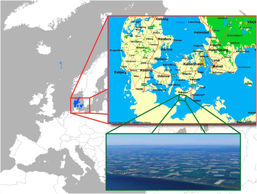
In the south of the island of Lolland, Denmark, extensive archaeological surveys precede the planned construction of a tunnel between Lolland and the German island of Fehmarn through the Femern Bælt/Fehmarnbelt (Figure 1; Sørensen Reference Sørensen2017).
Location map of the excavation area of the Femern project. Today a straight coastline protected by a dike, the area comprised an ever-changing fjord landscape during the Stone Age. Background map in the public domain (via commons.wikimedia.org), map of Denmark by krak.dk, aerial photograph by google.com. Map by Museum Lolland-Falster.

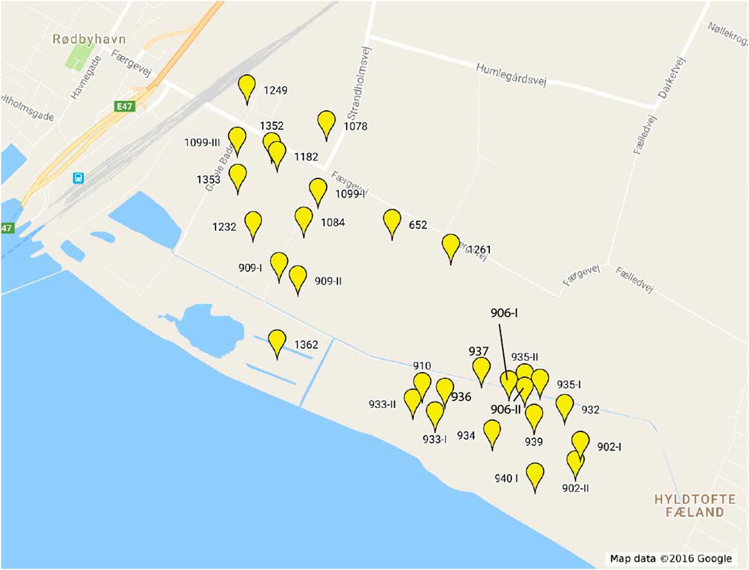
The excavations (Figure 2) have so far yielded evidence from a large time-span, from around 10,000 cal BC to the Iron Age. The period, which is represented best by our material, is the Early Neolithic, the time of the introduction of agriculture in Denmark. An entire economic and ritual landscape has been preserved by marine gyttja in the former Stone Age fjords (Sørensen Reference Sørensen2017). Even though there is evidence for animal husbandry, hunting, gathering and especially fishing continued to be of great importance. Large systems of stationary fishing devices have been found in the former Stone Age fjord. The rich estuarine environment attracted people throughout prehistory and caused large amounts of well preserved artifacts. At the same time, the heavy dependence on aquatic resources introduces a risk of reservoir effects in several sample types.
Locations of the different excavations of the Femern project. The excavations have numbers such as MLF01078 or MLF00906-I, on this map abbreviated as e.g., 1078 or 906-I.

ARCHAEOLOGICAL BACKGROUND
Reservoir corrections will enable 14C dating of marine or partly marine samples, such as human bones or food residues on pottery. The direct dating of pottery will be important to understand the dynamics of the Mesolithic–Neolithic transition, which is accompanied by a change in pottery style, from Ertebølle to Funnel Beaker pottery. The cultural transition accompanies the very gradual economic transition. Different aspects of the Danish Neolithic occur roughly contemporaneously, including domesticated animals, cereal agriculture, and Funnel Beakers. However, the exact relationship between those aspects has not been understood in detail. Did they arrive together as one “Neolithic package,” or were they adopted independently from each other? Precise and accurate 14C dates of all Neolithic aspects are crucial to answer this question, and may lead to a better understanding of the reasons for the transition to the Neolithic.
MATERIALS
At the time of writing, about 150 samples have been 14C dated for the entire project, and more dates are continuously being produced. Most of them are wooden artifacts and constructions, and thus not applicable for reservoir effect studies.
No pairs of unequivocally contemporaneous terrestrial and marine samples have been found yet, neither in the excavations nor in special cores taken for scientific analyses. We can thus only compare terrestrial samples with the sediment from the same level, and marine samples with sediment from their level. Therefore, we can only indirectly estimate the reservoir age for the study region. 14C dates of the following samples will be used to estimate the reservoir effect:
1. A wooden artifact on the sea floor and a sample of the sediment in which it was deposited
2. From a sediment core obtained in the former fjord:
∙ Plant remains and sediment samples from the same level
∙ Marine shells and sediment samples from the same level
3. Different chemical fractions of sediment samples from a terrestrial site in order to understand their origin—a discussion of sediment dates is necessary as we compare terrestrial and marine dates to sediment dates in 2.
The reservoir age estimates will be used in later phases of the project to correct e.g. 14C dates of food residues on pottery. In this paper, the corrections will be applied to ritually deposited bones and to samples dated for a sea level curve of the study area.
METHODS
Wood samples were pretreated with 1M HCl for 1 hr, 1M NaOH for 3 hr, both at 80°C, and lastly 1M HCl overnight at room temperature.
Sediment samples were pretreated using different methods. In the beginning of the project, sediment samples had been pretreated as “bulk” samples in the following way: 1M HCl for 1 hr, 1M NaOH for 3 hr in total, changed up to two times, and lastly 1M HCl overnight, all at 20°C. The other pretreatment method resulted in base-soluble (“humic”) and base-insoluble (“residual”) fractions of the sediment: 1M HCl at 80°C for 1 hr, repeated if necessary, 0.5M HCl NaOH at 80°C, repeated until no colour change was observed. Adding 6M HCl and slowly heating to 80°C precipitated the base-soluble fraction. Bulk sediment and the “residual” fraction thus represent similar extraction methods.
Shells were pretreated by mechanical and/or ultrasound cleaning, etching of the outer 10–20% with HCl, and removal of organic contamination by KMnO4 at 80°C. They were converted to CO2 using 80% H3PO4 in sealed evacuated containers.
14C dates and stable isotope ratios were measured at the Aarhus AMS Centre, Department of Physics and Astronomy, Aarhus University.
RESULTS
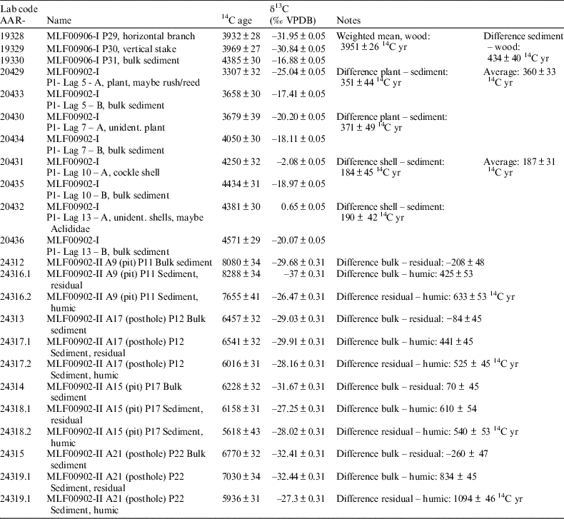
Table 1 lists the 14C dates that can be used to discuss the order of magnitude of the reservoir effect, and the accuracy of sediment dates. The excavations from which these samples derive are mapped in Figure 2. 14C dates for the sea level curve are presented in Table S1 in the supplementary information.
Paired 14C dates on wood, sediment and shells, which can be used to estimate reservoir effects.

Reservoir Effect Calculation
A horizontal and a vertical stake from a woven mat of hazel branches, which was lying on the former sea floor, were dated (Table 1). It had most probably been part of a stationary fishing device, such as a fish weir or fence, before it was deposited on the sea floor. A sediment sample of the sea floor was dated as well. Not surprisingly, the 14C dates of the two wood samples agree with each other. The sediment is more than 400 14C yr older than the wood. As it has a marine δ13C value, part of this age difference must be ascribed to the marine reservoir effect.
Four pairs of samples from a sediment core from the excavation MLF00902-I were dated (Table 1). Two shell samples were almost 200 14C yr younger than the surrounding sediment. This indicates that the sediment holds other age offset sources than just the reservoir effect.
Two pairs of unidentified plant and sediment were dated as well (Table 1). The plants are probably wetland plants, and are expected to have low reservoir effects due to heavy reliance on atmospheric CO2. This is supported by the fact that the age difference between the plants and the sediments is greater than the age difference between the (marine) shells and the sediments.
If we assume that the ~200-yr “sediment offset” also applies to the first sediment sample, AAR-19330, a reservoir effect can be calculated: R = (diff. sediment-wood) – (diff. sediment-shell) = 434±40 – 187±31 = 247±51 14C yr. However, this is only a rough estimate, and should in the future be replaced by a larger dataset of paired samples of terrestrial and marine origin, or by many terrestrial and marine samples from a long sediment sequence.
14C Dating of Sediment Samples
Sediment samples from four features (pits and postholes) from the excavation MLF00902-II have been dated using different fractions (AAR-24316–24319 in Table 1). Firstly, half of the sample was pretreated as “bulk sediment”, i.e. pretreated and dated in the same way as the many samples from the core drillings in the beginning of the project. Secondly, the base-soluble (“humic”) and base-insoluble (“residual”) fractions of the other half of the sample were extracted and dated. Therefore, we can compare three dates of the same sediment sample. In all four cases, the date on the humic fraction is the youngest. In three out of the four cases, the residual fraction is the oldest and the “bulk” sample represents an intermediate age. This is to be expected, as bulk sediment and residual fraction are prepared with similar methods. The main difference is the fact that the complete removal of the base-soluble fraction was attempted for the residual fraction. Apart from these general tendencies, the age differences between the fractions are not consistent enough to allow the calculation of correction factors, which could be applied to compare “bulk” sediment dates from the early phases of the project with sediment dates from other studies. The δ13C values of those samples indicate the terrestrial origin, which agrees with their origin from features such as pits and postholes. The temporal relation between the formation of the organic material in the sediment and the construction of the pits and postholes, however, is unknown.
DISCUSSION
Reservoir Effects
The reservoir effect in the Syltholm fjord is estimated to be about 250±50 14C yr.
This value is not unusual for the Western Baltic: a mollusk shell collected in 1888 at a water depth of 19 m off Lolland had a reservoir age of 302±50 14C yr (Lougheed et al. Reference Lougheed, Filipsson and Snowball2013). Reservoir ages between 200 and 270 14C yr were suggested for the Kattegat prior to 4500 BP (Olsen et al. Reference Olsen, Rasmussen and Heinemeier2009). Freshwater influence can be neglected, as the carbonate-rich freshwater in the streams on Lolland would increase the reservoir age (Lougheed et al. Reference Lougheed, Filipsson and Snowball2013).
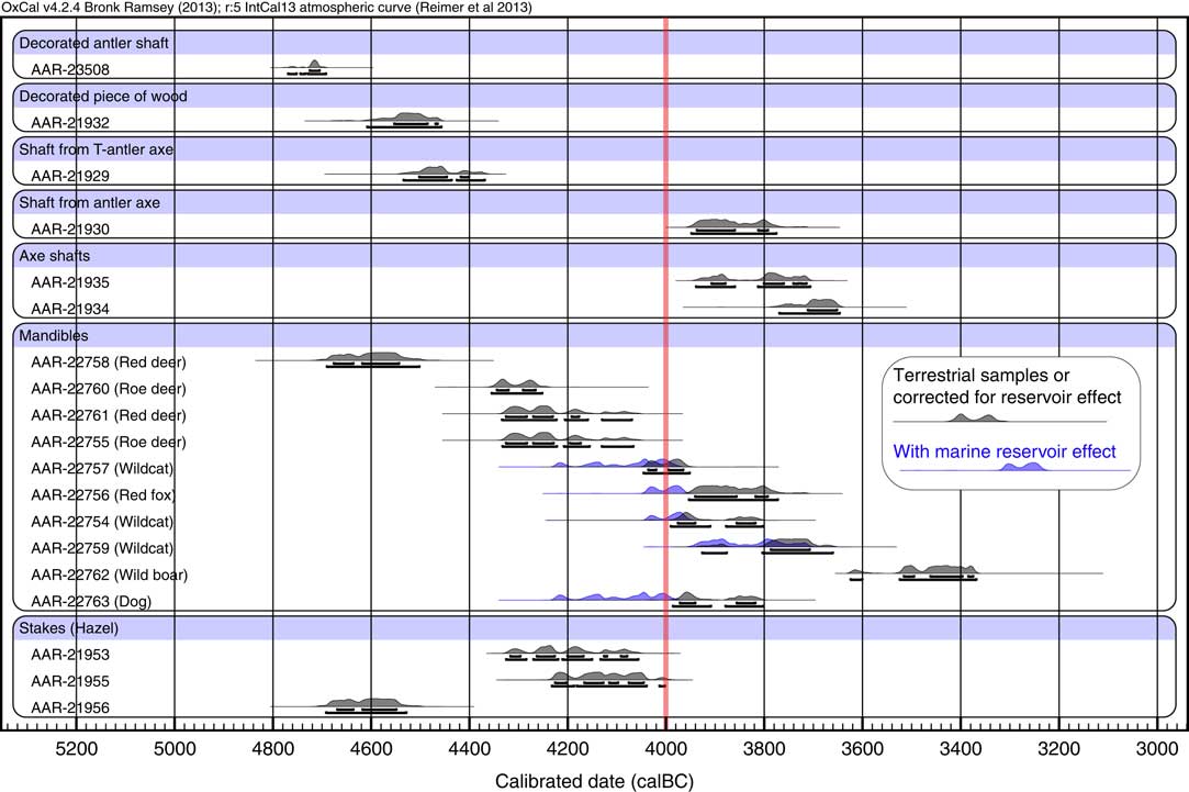
This is useful information when later dating other sample types, such as food residues on pottery or human bones. Already now, taking the marine reservoir effect into account helps to precisely date the bones of omnivores and carnivores, as the example in Figure 3 illustrates. The samples originate from an area of about 25 m2, where about 50 mandibles, numerous artifacts and other bones had been deposited (Sørensen, Reference Sørensen2017). 14C dates on mandibles from different animals have been corrected for the marine reservoir effect. The reservoir age of the marine food component consumed by omnivorous animals is expected to be greater than the 250 14C yr we found for the Syltholm fjord: the dogs would not have consumed mollusks from the fjord, but fish caught within the fjord and further out in the open Baltic.
Radiocarbon dates with and without reservoir correction from an area where artifacts and animal bones, especially mandibles, had been deposited in the shallow water of the fjord. Calibrated with OxCal 4.2, IntCal 13 (Bronk Ramsey Reference Bronk Ramsey2009; Reimer et al. Reference Reimer, Bard, Bayliss, Beck, Blackwell, Bronk Ramsey, Buck, Cheng, Edwards, Friedrich, Grootes, Guilderson, Haflidason, Hajdas, Hatté, Heaton, Hoffmann, Hogg, Hughen, Kaiser, Kromer, Manning, Niu, Reimer, Richards, Scott, Southon, Staff, Turney and van der Plicht2013).

It has therefore been assumed that the marine reservoir effect is about 400 years and that the endpoints for 100% terrestrial and 100% marine diet are –21‰ and –10‰, respectively. Later, when more data are available, those assumptions will of course be replaced by the actual reservoir effect and isotope baseline measured in the project. However, already now a general tendency can be observed: after correction, the omnivorous animals are shifted towards younger ages. There appears to be a shift in the deposition of mandibles from deer to omnivorous animals, before or at about 4000 cal BC. Not regarding the young date of a wild boar, one could conclude that there is a shift from animals hunted for meat to those hunted (or kept, in the case of the dog) for fur.
Also for the reconstruction of a sea level curve (Table S1), reservoir effects are important. The following discussion will highlight some of the challenges with the use of 14C dates for sea level reconstruction.
Fjord Sediments and Terrestrial Sediments
All sediment samples from aquatic contexts of this project have marine δ13C values. Therefore, the marine reservoir effect must be present in those cases, due to decayed marine organic matter from marine plants and animals. Influx of terrestrial material into the fjord appears to be of lesser importance. However, the sediment samples had even larger 14C ages than marine samples from the same layer. Therefore, sediment dates must contain another offset source than only the marine reservoir effect. For example, parts of the seafloor could have been eroded away before the shells were deposited, or organic material could have been redeposited centuries after its initial deposition (Winn et al. Reference Winn, Erlenkeuser, Nordberg and Gustafsson1998; Rößler et al. Reference Rößler, Moros and Lemke2011). In a sediment sequence from the coast of the Littorina Sea, for example, the age difference between sediment and terrestrial macrofossils was even up to 1100 and 700 14C yr (Hedenström and Possnert Reference Hedenström and Possnert2001).
When comparing 14C dates of the sediment samples from terrestrial features with each other, one has to take the deposition environment into account—terrestrial sediments and marine sediments from our excavations cannot be compared directly. The former can have accumulated during soil formation processes, while the latter represent marine and terrestrial material in different proportions, which were deposited under water in the shallow fjords.
Irrespective of the depositional environment, however, this small case study highlights the uncertainties associated with sediment dating (see e.g. Olsson Reference Olsson1979). The different ages of the base-soluble and insoluble fractions indicate the different carbon sources for the sediment. The same effect was observed in sediments from the Baltic, which were used to date the Littorina transgression (Rößler et al. Reference Rößler, Moros and Lemke2011). Sediment dating should therefore be avoided in those cases where human activities are to be dated. In the literature, for sediments containing too low amounts of terrestrial macrofossils, dating of organism-specific compounds or biomarkers is suggested (Eglinton et al. Reference Eglinton, Aluwihare, Bauer, Druffel and McNichol1996; Hatté and Jull Reference Hatté and Jull2013). In the context of the Femern project, 14C dating paired samples of sediment and terrestrial remains is important in order to calculate correction factors. This would enable us to make use of the many dates on bulk sediment from the early phase of the project, where core drillings yielded no other datable material than bulk sediment.
SAMPLES FOR A SEA LEVEL CURVE
Tree Stubs
Tree stubs are commonly used as sea level indicators (Dörfler et al. Reference Dörfler, Jakobsen and Klooß2009). Different tree species die at different water levels and can thus be used to reconstruct the sea level, provided that the cause of death for the tree was the rising water table. Some trees die already when the groundwater table rises, some others survive in wetlands and only die due to permanent inundation or flooding by the sea. The reliability of the 14C date of a tree stub relies mainly on the sample selection process. Besides ensuring that the tree died due to the rising sea level, one should select wood from the outer, youngest, tree rings and avoid bark, which could be significantly older.
Wetland Plants
Generally, aquatic plants should be avoided for 14C dating. Even floating plants, which are expected to assimilate atmospheric CO2, can have high reservoir effects (Philippsen and Heinemeier Reference Philippsen and Heinemeier2013). This can be due to internal air flow through the plant to the upper surface of the leaves (Dacey Reference Dacey1980), or due to DIC degassing (Hatté and Jull Reference Hatté and Jull2013). Also sphagnum macrofossils can be affected by reservoir effects due to the mineralization of old organic matter (Hatté and Jull Reference Hatté and Jull2013). Reed is found in great numbers in the sediments of the study area. It is expected to rely largely on atmospheric photosynthesis and to have only a small risk of reservoir effects (Heikkinen and Äikää Reference Heikkinen and Äikää1977). However, reed can assimilate other carbon sources as well, including DIC, sedimentary CO2 and nutrients from previous growing seasons that had been stored in the rhizomes. As reed thrives both in the (wet) terrestrial environment and at water depths of up to 4 m (Haslam Reference Haslam2010), and as its roots can extend to up to 4 m below ground level (Haslam Reference Haslam2010), this species adds an extra depth uncertainty to the sea level curve (Table S1).
Seeds and Other Terrestrial Macrofossils
Generally, the most fragile terrestrial macrofossils should be chosen for dating, because they are most probable to show indications of bioturbation or redeposition, if present. Highly resistant seeds, such as those of Carex, can also be intact in reworked sediments and should therefore be avoided (Hatté and Jull Reference Hatté and Jull2013). Unidentified seeds could originate from aquatic or wetland species and should therefore be avoided as well.
Sediment Compaction
Layers can be eroded or compacted, so level measurements can be problematic (Jakobsen et al. Reference Jakobsen, Meurers-Balke, Hoffmann-Wieck and Thiede2004; Dörfler et al. Reference Dörfler, Jakobsen and Klooß2009; Baeteman et al. Reference Baeteman, Waller and Kiden2011). At the Femern excavations, this compaction can be observed with stakes and other wooden artifacts, which show a zigzag-profile today. The compaction is not uniform and varies considerably between sediment types. For example, at one site, a peat layer of about 20 cm had compacted by 5 cm, while the underlying moraine clay and the overlying marine gyttja showed almost no compaction.
Draft of a Sea Level Curve
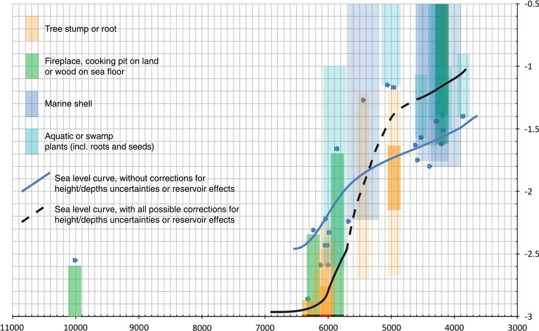
Taking into account all uncertainties, reservoir effects and level indicators, the shape of the sea level curve changes. Figure 4 exemplifies this effect with some of the dates (Table S1) that will be used to reconstruct the sea level curve for the study area. 14C ages and depth measurements are displayed as blue symbols. The blue curve is a sea level curve only based on these measurements. Additionally, shaded areas above, below, or around the dates display the range of possible sea levels and ages for each data point. For example, artifacts that have been deposited horizontally on the former sea floor indicate that the sea level must have been higher than the artifacts’ level. A fireplace, in contrast, must have been above sea level, although it is uncertain how much. The black curve is drawn through those shaded areas and thus represents the most probable sea level at a given time. The resulting sea level curve is overall steeper than the blue curve and does not show the fluctuation that is present in the blue curve. However, at least at the present level of resolution, uncertainties in height are more important than uncertainties in 14C age due to e.g. reservoir effects. Another challenge is the fact that the preliminary dataset lacks samples from the marine environment for the early phases of the project, and samples from the terrestrial environment for the later phases. However, as more 14C dates are being measured and excavations are expected to continue in the future, improved sea level reconstructions will be possible.
Examples of the effects of uncertainties in depth and 14C ages on sea level reconstruction. 14C dates and levels (below present sea level) of samples that can be used for sea level reconstruction are marked with blue symbols. Shaded areas represent the possible ranges of the past sea level. (See online version for colors.)

CONCLUSION
Although systematic sampling for reservoir effect studies had not been an option in the study presented here, it was still possible to extract some research results from analyses made during the rescue excavation.
The marine reservoir effect in the study area appears to be approximately 250 14C yr. Freshwater reservoir effects due to carbonate-rich freshwater influence have not been observed. Further research is necessary to follow the development of the marine reservoir effect through time. The reservoir effect in the shallow fjords of the study area might be lower than the reservoir effect of fish or marine mammals that lived in deeper parts of the Baltic. Therefore, not only shells, but also fish bones should be 14C dated in comparison with contemporaneous terrestrial material. The average reservoir effect of fish and marine mammals caught by the people is expected to be larger than the 250 14C yr of the fjord.
14C ages of marine sediments are almost 200 14C yr older than marine shells from the same layer. Therefore, erosion and redeposition of sediments have to be taken into account when dating marine sediments. From earlier phases of the project, large numbers of sediment dates are available. They had been used to roughly estimate the age of the organic sediments. The results of this study show that the ages of the sediment samples have to be corrected by 450–600 yr to obtain the correct time of deposition. Further research will show whether this applies to the entire fjord system during all periods.
For the sea level curve, reservoir effects will be relevant when including shells or aquatic plants, although uncertainties in depth/height are an important issue as well. Taking the different corrections into account, the sea level curve becomes significantly steeper than the one based on uncorrected depth/height relations.
ACKNOWLEDGMENTS
I would like to thank all archaeologists and technical staff from Museum Lolland-Falster for their support in the field and magazines, for their constant helpfulness and interest in scientific archaeology. I had many good discussions about the archaeological part of this study with Søren A. Sørensen. He also made useful comments on an earlier version of this paper.
SUPPLEMENTARY MATERIAL
To view supplementary material for this article, please visit https://doi.org/10.1017/RDC.2018.6