Introduction
This paper is based on a report, made in collaboration with the Department of Antiquities and the Italian Mission of Chieti University, which was submitted to UNESCO.Footnote 1 The work develops previous ideas about buffer zones, adapting the proposed regulations on the local particularities. The hope is that such work will help the Libyans to build their own local regulations to rescue the Cyrenean landscapes which are threatened.The surroundings of Cyrene are the setting for a tragedy that has largely been ignored by the world. The urban encroachment, strong demographic pressure, unsustainable exploitation of resources and unplanned growth of infrastructures and services are threatening the archaeological heritage of Cyrene.
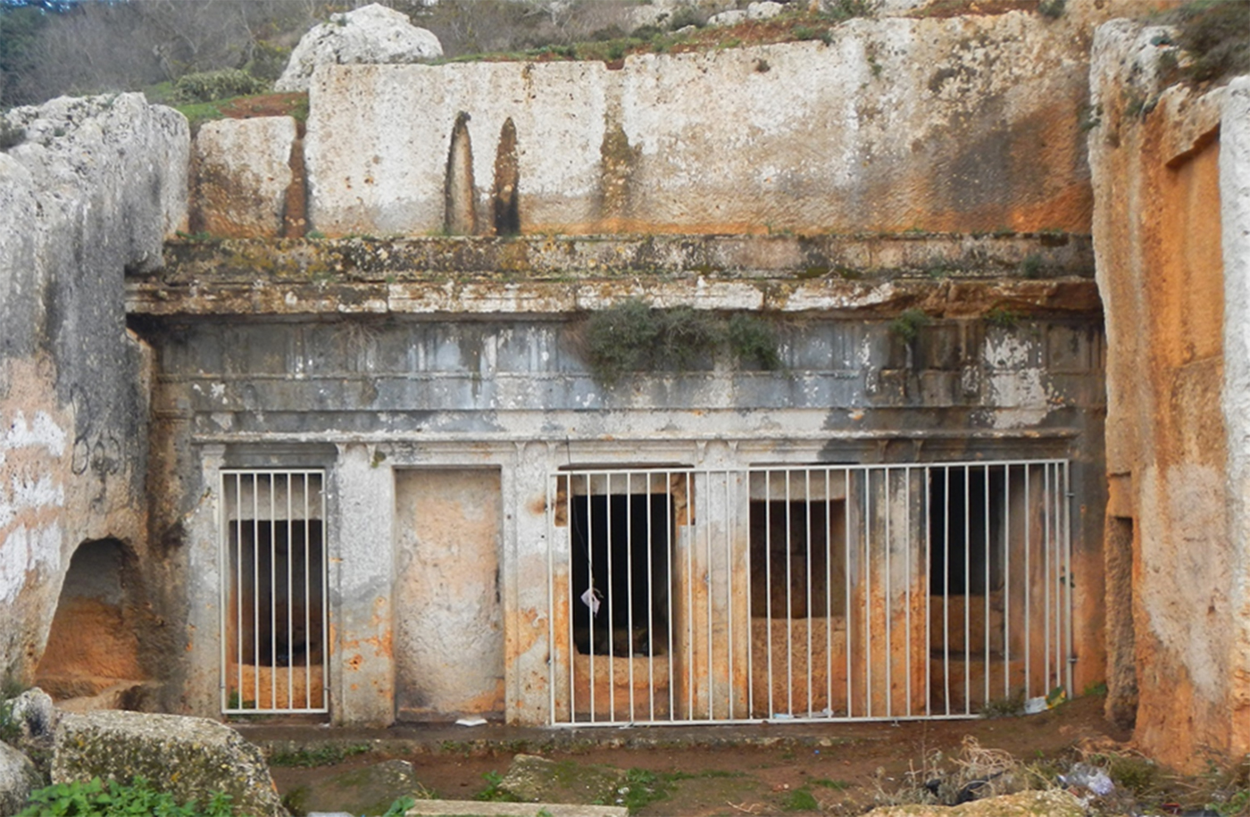
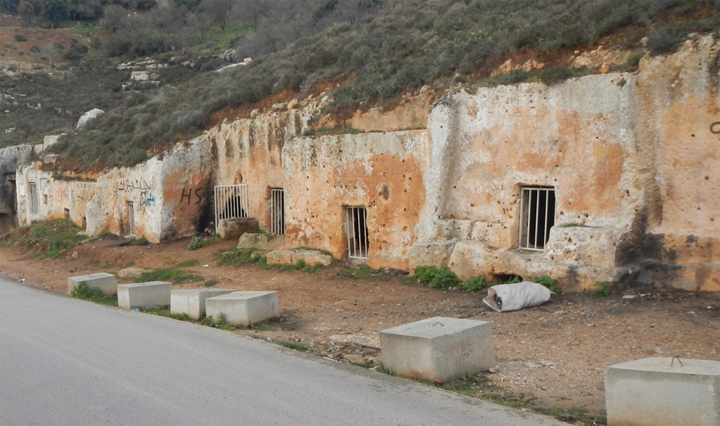
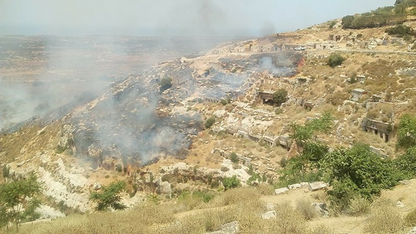
The necropolis of Cyrene, one of the most beautiful in the Mediterranean, is the main victim, with its thick spread of monumental tombs all around the ancient city. The necropolis suffered from the development of New Shahat during the twentieth century (Thorn Reference Thorn2005, 13–15) which devoured important parts of the Southern and Eastern cemeteries, but the scale and speed of today's destructions is astonishing. In the past the local communities had an intense cultural relationship with the ancient necropolis (Cherstich I. in Cherstich, Menozzi et al. Reference Cherstich, Menozzi, Antonelli and Cherstich2018, 141–3), but nowadays many landowners ignore the value of the ancient heritage. Exploiting the chaotic situation following Reference Cherstich2011, many locals, who have previously respected the antiquities, have started destroying the ancient monuments, clearing areas to get more space for building. Roads are arbitrarily opened with bulldozers, heaping up blocks of ancient structures and erasing rock-cut tombs; concrete walls surround new private buildings that are invading the necropolis. Furthermore, the general development of the areas (public roads, services, pipelines) seems to expand with no concern for the antiquities, even when such works are planned by public administrations.
The Department of Antiquities (DoA) has always tried to protect the heritage, but today the destructions are so great that the DoA is often powerless, in a complicated situation where local legislation on heritage protection seems to be ineffective.
Terminological issues (L. Cherstich)
We will start by defining the terms ‘core’ and ‘buffer’ to explain the zones in relationship to the UNESCO ‘Operational Guidelines for the Implementation of the World Heritage Convention’. In particular, paragraph 104 of the 2017 version of this document defines the use of the buffer zones and also mentions issues concerning boundary regulations, protection and property, specifically for the UNESCO sites.Footnote 2 Certainly, the general definition of ‘buffer zones’ as presented in the paragraph 104 needs proper consideration in order to be applied to the specific case of Cyrene.
First of all we must consider the size, the boundaries and what we mean by ‘property’ when talking about archaeological sites in Cyrene, from where the buffer zone should spread, since those boundaries were chosen in a problematic way. The property, that is the ‘Archaeological Site of Cyrene’, as shown in the maps of the UNESCO World Heritage List, clearly include only the urban remains of the ancient city, completely ignoring the incredible density of the archaeological remains in the extra-urban area.Footnote 3 The property boundaries basically ignore the huge necropolis (Thorn Reference Thorn2005), the extramural sanctuaries (Menozzi Reference Menozzi2015 and Reference Menozzi, Russo Tagliente and Guarneri2016), the ancient road network, the monumental gsur (fortifications) and basilicas and farms (Abdalrahim et al. Reference Abdalrahim Sheriff Saad, Farag Abdel Hati, Antonelli, Menozzi, Petraccia and Somma2016) and, more generally, the whole ancient landscape surrounding the city that has been miraculously preserved for centuries, at least until recent times.
The boundaries seen in the World Heritage Sites (WHS) maps seem (possibly unconsciously) to reflect the same mentality which caused the destruction of the necropolis from the 1960s onwards, when the modern inhabitants of Italo-Turkish Old Shahat were removed from their houses inside the ancient city to new houses ‘outside’ the site. The antiquities were felt to be mainly limited to the major excavations and monuments inside the ancient city, and the creation of modern Shahat thus destroyed much of the South-Eastern ancient cemeteries and associated remains such as roads, sanctuaries and ancient farms.
To (at least partially) solve this problem the concept of two core zones is here used to include both the ancient city inside the WHS property (Core Zone 1) and the better preserved and partially fenced parts of the necropolis that are outside the WHS property (Core Zone 2).The use of a core zone then surrounded by a buffer zone, as different kinds of conceptual delimitations, is not common on WHS but can be seen in UNESCO zoning schemes connected to ecological sciences.Footnote 4 The areas we are discussing in Cyrene are not just archaeological, but also include important sections of geologic, topographic and environmental landscapes that have been preserved for centuries and now also need protection. Moreover, the concept of core zones and buffer zones and their different uses as legal instruments to define and to defend a territorial assessment, have already been used in the past, specifically for Cyrene and other Libyan sites, in articles (Abdulkariem and Bennett Reference Abdulkariem and Bennett2014,158), as well as in technical reports for UNESCO or other institutions.Footnote 5
Beyond the core zone one must add the proper buffer zones organized according to different mechanisms and degrees of protection. Obviously, important antiquities are well attested in these areas but buffer zones consider the different levels of preservation of the ancient landscape and the existence of modern Shahat, inhabited by a dense and growing population. The 2017 operational guidelines (paragraph 104) prescribes the creation of ‘appropriate mechanisms’ but these must be of course be applied to the specific situation. The use of different levels of buffer zones with different mechanisms and degrees of protection is used for other WHS properties.Footnote 6 This is particularly necessity when a WHS property is in a modern urbanized context where the needs of an already existing population must be dealt with.
Legal matters (A. Abdalrahim Shariff Saad and O. Menozzi)
Libya has legal regulations: the most recent act is specifically dedicated to the ‘Protection of monuments, museums, ancient cities and historical buildings’, known as Law 3 year 1424/1995. This law is quite detailed and mentions specific situations, rules, restrictions and penalties for transgressions, including fines and imprisonments. The problem, however, is the inability of the relevant authorities to act, and staff shortages for monitoring the territory and applying the law, and the inexistence of local master plans for controlled and sustainable urban development.
The law of 1995 is based on previous legislation, enshrined in Law 2 of 1983 concerning monuments, museums and documents, and Law 116 of 1972, relating to urban development and including a section on urbanization in archaeological areas. Moreover, the complete legal system for Cultural Heritage in Libya is based on a ‘re-adaptation’of the Italian Law 1089, known as LeggeBottai, dating to the 1 June 1939, which takes into account local needs and issues. Going back to the contents of Law 3 of 1424/1995, article 1 sets out different types of cultural heritage:
– Real Estate: remains of cities and archaeological hills, castles, forts, fences, mosques, schools, religious buildings, cemeteries and caves, whether in the ground or on the surface or under the territorial waters, as well as monuments of distinctive architectural character, sites and historical evidence related to the jihad of the Libyans and their struggles and experiences and linked to the political, cultural and social history of the country.
– Transferable/movable effects: such as statues, mosaics, pottery pieces, glass, ancient coins and engravings as well as some traditional industries.
– Archaeological Excavations: aimed at finding real or permanent effects by systematically excavating the earth, studying its surface, studying the waterways, lower layers of lakes and bays, and deep in the territorial waters.
– Natural History Collections: related to human, animal, plant, rock, stone and mineral fields, as well as geological formations with natural and tourist characteristics.
– Museums: scientific and cultural institutions that aim at preserving, documenting and presenting the human and natural heritage, scientific and artistic development, and spreading knowledge and awareness among the masses.
– Documents: written and engraved texts on any material or component such as stone, pottery, leather, metals and bones … all of which are related to human civilization and its experiences, including magnetic tapes, photocopies, manuscripts, documents, arguments, treaties, maps, pamphlets, resolutions, publications and other documents and papers that have been fifty years old.
– Ancient cities, neighbourhoods and historic buildings: that is architectural entities that are homogenous, independent or integrated, within conventional boundaries or within walls surrounded by houses, schools, mosques, markets, streets, gardens, monuments, monuments and monuments within the old neighborhoods and cities that have been established for a hundred years or more or which have witnessed an important historical event.
Concerning the buffer zones, the first and the last categories are particularly important, which include a large variety of archaeological heritage. In addition, article 1 also mentions the authorities: scientific and technical institutions responsible for the management, organization, care and protection of monuments, museums, documents, ancient cities, neighborhoods and historic buildings, which is essentially the DoA, and specific committees and institutions, that may also include the local baladiyat (administrative divisions/municipalities), but only if followed by the scientific and technical institutions. Article 2 mentions the purpose of the law, in a very general way, for protecting the monuments, museums, documents, old cities, neighborhoods and historic buildings; and for establishing the regulations.
In order to help in the application and implementation of the law, article 3 discusses the support of specific ‘Scientific and technical advisory committees’. This article should certainly be taken into account for planning interventions and infrastructures within the buffer zones: agreement and committees including DoA and local scientific (universities, museums, research centres) and territorial institutions (municipalities, police, cultural associations) could be a great help in monitoring a sustainable urban development, for controlling the application of the law and for involving the local population and raising local awareness of their cultural heritage.
The following 47 articles cover protection in detail. Some of the articles are crucial for the protection of monuments and sites within the buffer zones: for instance, article 5 is important for establishing that all the categories of cultural heritage, movable and immovable property whether in the ground or on its surface or under territorial waters … . shall be regarded as public property, except for those recorded in the names of individuals and bodies during previous legislations. Article 6 regulates private owners within archaeological contexts, stating that a land owner, beneficiary or exploiter shall not in any way acquire the right to dig, search for the effects thereon or to dispose of the effects found in its interior or on its surface except in accordance with the provisions of this law; it shall not be permissible to dispose of buildings located within archaeological areas or to make any changes in their uses without the consent of the competent authority. Article 7 adds that no public or private entity can make plans, amendments or carry out works within these contexts, without the authorization of the authorities, including projects for the division of land for buildings or the construction of new roads or making any amendments. Article 8 states that It is prohibited to destroy or damage the real estate or movable property, to write or dig it, to change its features, … to destroy traditional industries of an archaeological nature and it is a need to prevent their export or smelting. Thus specific rules and punishments against the illicit traffic of antiquities already exist in current law, as also in articles 22 and 23; however, the real need, obviously, is to apply them.
Following 2011, article 9 has become important, mentioning that The competent authority shall take the necessary measures to protect the monuments in time of peace and war, in agreement with the relevant authorities, and to prepare the bunkers necessary to save the heritage, especially precious artefacts, subject to the provisions of the international conventions to which Libya is a party…The sites and cities of the archaeological sites of vital importance and the competent authorities to facilitate their registration internationally. The following articles clarify in detail specific cases and are very important for demonstrating how the law already provides strong foundations for the control of sites and monuments. Article 16, for instance, specifies that without the written permission of the competent authority, no alteration or alteration of the registered real estate effects owned by non-state or its use in non-tourist, historical or scientific purposes shall be permitted. No new building may be assigned or attached to a registered archaeological property or modifications to buildings adjacent to registered real estate effects shall be made without the written permission of the competent authority; and also article 17 forbids anyone to construct quarries, factories or other shops or establishments at a distance of less than 500 meters from the real estate effects, without the approval of the competent authority, and in accordance with the conditions set forth in this regard.
For archaeological investigations during urban development and rescue/preventive excavations, articles 24 and 15 are particularly important, because they establish that the competent authority may carry out archeological excavations in any place in Libya and, for this purpose, shall have the right to seize the properties owned by individuals and the public and private entities and to take the procedures of their general public benefit in accordance with the provisions of Law No. 116 of 1972 for the organization of urban development. Or temporary local field investigations in any part of the territorial territory and territorial waters of the State(24) and No one may carry archaeological excavations without a permit from the competent authority, even if he is the owner of the place where the excavation takes place. Excavations are authorized only for archaeologists and archaeological missions, which are composed by associations, institutes and scientific institutions, in accordance with the conditions specified by the executive regulations (25). Article 26 mentions how to apply for permission to excavate, specifying that a request must include a project, plan, drawings, report and details and reports and registration of the finds must be managed following regulations in 8 other articles. From article 35 to 49, similar rules are set out for the protection of old cities, neighbourhoods and historical buildings, mentioning that old cities, neighbourhoods and historic buildings with all their features, monuments and finds are historical cultural property of humanity which can not be disposed of in any way except by the competent authority and the executive regulations shall determine the relevant conditions (35), and that it is prohibited to allocate or use historical buildings in old cities and historical neighbourhoods for housing purposes or to engage in public or private economic activities except in accordance with the conditions specified by the executive regulations of this law (37); moreover it is prohibited to carry out any work or construction or to carry out any activities that would cause or cause harm to the old cities, neighbourhoods or historical buildings in the surrounding area… (38).
Article 50 lists penalties connected with damage to monuments and sites, and more generally to all cultural heritage, stressing the unique patrimony of Libya and humanity. In this respect the law is already effective, and just needs modernizing, such as improving the section about rescue and preventive excavations related to urbanization and private or public works, and introducing stricter rules.
However, the application of the rules remains a serious problem until the DoA and their territorial offices have greater powers for preventing and stopping damage to buildings and illicit excavations. Moreover, the local police offices and municipalities should be regularly consulted by the DoA and work in close collaboration, in spite of and beyond the political and tribal issues. In order to create a wider sense of belonging and ethnical awareness of the cultural heritage within the local population, schools, ministries and cultural and recreational associations must also be involved. Recently at Shahat, for instance, both the local scouts and a local association have been involved in cleaning the necropolis and monitoring some areas, such as at AinHofra in 2013 when a local youth association helped check the wadi.
General issues and recommendations(O. Menozzi, E.Di Valerio, M.G. Di Antonio)
The following issues and general suggestions must be considered when trying to create regulations to protect the Cyrenean heritage. These subjects are important not only for Cyrene itself but also, more generally, for all of Libya's heritage.
a) A new Libyan system of rules and laws for protecting the cultural heritage. Libya, in general, is very rich in architectural, archaeological, ethno-anthropological and natural heritage. Consequently, it must be a high priority to create a new legal system with appropriate rules concerning the safeguard, sustainability and valorization of such an extraordinary heritage. The new laws and rules must outline provisions for fines for those who do not respect them, and the funds gained through such payments could go directly to the DoA, in order to help the maintenance of the sites.
b) Safeguard of the widespread heritage. The Libyan archaeological heritage includes not only the wonderful ancient urban contexts like Cyrene, Sabratha and Lepcis Magna, but additionally, the Libyan landscapes display an amazing number of monumental sites (villages, ancient farms, fortifications such as monumental gsur, aqueducts, cemeteries) and even single monuments spread across the territory (mausolea, monumental tombs, extra-urban sanctuaries, churches) which demonstrate the widespread nature of Libyan heritage, not yet completely known and recognized by UNESCO. Each of these neglected sites deserves more attention, since their rural position often means greater difficulties safeguarding them: they need core and buffer zones to protect them.
For instance, in Tripolitania the Villa Silim, a splendid Roman monumental villa, closely related to Lepcis Magna, is located 15 km from the city and needs a specific study in order to plan its core and buffer zones. A Cyrenaican example of this kind of ‘secondary site’ could be the village of Lamluda/Lamlucah (20 Km east of Cyrene). It has an organized urban plan, a very monumental appearance, well-preserved monuments and its core zone already has fences. But Lamluda needs to be recognized so that it is better protected: there are other villages close to Cyrene, such as Mgarnis, Jubbra, Sirat al Bab and Gabl Younus.
c) Training cultural heritage police: an archaeological police force must be created in Libya for the careful monitoring of the sites, as well as for tackling looting and the black market sale of archaeological finds. This special police force would collaborate closely with Libyan offices of the DoA, but also with UNESCO, Interpol, Blue ShieldsFootnote 7 and Special International Police forces to track down Libya's heritage illicitly obtained on the international black market and through illegal auctions.
The following considerations set out issues regarding the protection of the ancient heritage in core and buffer zones of Cyrene.
1. Urban master plans. Each Baladiyah needs an urban master plan including the recommendations and prescriptions for respecting the heritage in the archaeological core and buffer zones.
2. Committee board for evaluating projects. A special professional committee board, including archaeologists, conservators, architects and technicians from DoA, Baladiyat and local Universities (and if necessary consultants from foreign Institutions and Missions) must be created to carefully analyze, case by case, requests for works in the areas of the buffer zones, and to suggest proper solutions to protect the heritage when it is at risk.
3. Presentation of projects to Baladiyat and DoA. The Baladiyat must be obliged to immediately communicate to the local DoA all types of project (private or public) planned within the core and buffer zones. Moreover, collaboration between Baladiyat and the DoA is essential for the best bureaucratic procedures to make such communications quick and effective.
4. Guardians. The DoA must increase the number of guardians actively controlling the sites on regular schedules, in order to monitor even remote sites.
5. Training for monitoring. The DoA must select and train inspectors (archaeologists, experts in landscape archaeology and topographers) for the monitoring of the archaeological areas, regularly visiting the sites, but also through protocols of remote control (remote sensing, drones, satellite and aerial photo-interpretation). The inspectors must be ‘responsible’ for specific areas, in order to follow more closely the evolution and issues of their areas in collaboration with the police and guardians.
6. Education of the local communities. Conferences and meetings with students, cultural associations, school classes, scout groups and the local population must be regularly organized by the DoA and the Baladiyat in order to educate the local population and to organize groups of volunteers and collaborators to help the DoA clean and monitor and protect the monuments.
Cyrene: Core and buffer zones (O.Menozzi, E. Di Valerio, M.G. Di Antonio)
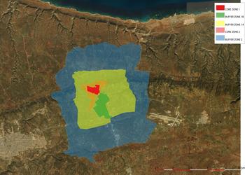
Here we outline the proposed ‘protection zones' around Cyrene (Figures 1 and 2). There are basically two core zones (Core Zone 1 and Core Zone 2), one buffer zone with two sub-zones (Buffer Zone 1a and Buffer Zone 1b) and an external buffer zone (2). These zones have been designed to consider specific local characteristics, including not only the archaeological heritage but also the ethno-anthropological and architectural heritage. Prescriptions and recommendations are also proposed, tailored, as much as possible, to the specific needs of the heritage present in the specific zones.
A general view of the buffer zones proposed for Cyrene, mapped on a satellite view of the territory (shot from the GIS, Archive of the Archaeological Mission of Chieti University in Libya).

Shot of the proposed limits of the buffer zones on a topographic base (shot from the GIS, Archive of the Archaeological Mission of Chieti University in Libya).

CYRENE – Core zone 1: the ancient city
General description
The first core zone is the entire ancient urban context of Cyrene, including the Sanctuary of Apollo, the Sanctuary of Zeus and all the quarters of the ancient town: the Acropolis, the Agora, the Gymnasium, the Roman Quarter and the Northern Quarter. The area is already partially surrounded by fences. Within this area there are buildings belonging to public institutions (the offices of the DoA, the Archaeological Museum complex, the Ethnographic Museum, the Police station, the DoA guest house), as well as private houses, services and infrastructures. Many of these buildings are of architectural interest because they are part of the old, Italo-Turkish town, and therefore need to be preserved as part of the local architectural and cultural patrimony.
Risks/Threats
Despite the fences, the risks and threats are numerous, such as vandalism, lack of maintenance, looting of both buried and open-air antiquities, unauthorized building works, heavy pasturing with large animal herds destroying fences and objects, quarrying.
Proposed Regulations
1. Avoid new buildings and infrastructures, except for essential services whose only purpose is to improve the area using non-invasive approaches. All new works must be approved by the DoA.
2. Avoid building or enlargement of existing buildings, except for minor or essential works aimed at improving the area using non-invasive approaches. All new works must be approved by the DoA.
3. Avoid any archaeological excavation without the permission of the DoA.
4. Avoid the grazing of animals on ancient monuments.
5. Avoid aggressive agricultural works on public lands. On private properties agricultural works must avoid deep ploughing (over40 cm).
6. Avoid having rubbish dumps within the core zone.
7. Prohibit littering, vandalism, damage or graffiti on ancient monuments.
8. Prohibit collection of archaeological materials and objects without proper and legal authorization from the DoA.
Recommendations
1. Build appropriate new fences and infrastructures for the two main gates to the archaeological site.
2. Organize an efficient service of control through guardians frequently checking the different areas.
3. Install a video control system connected to both DoA offices and Police stations.
4. Re-organize the archaeological tourist routes and pathways in a more appropriate way, with informative panels and rubbish bins. Future improvement could include the digitization of visitor information (creation of apps, use of 3D reconstructions, virtual reality).
5. Any restoration within the area must be based on international/UNESCO/ICCROM protocols and approved by the DoA.
6. Install appropriate lighting for enhanced display and security.
Notes
A possible strategy for fulfilling many of the above points may be the progressive acquisition of private lands by public bodies.
CYRENE – Core zone 2: The monumental suburb. The necropolis and the extramural sanctuary
General description
Core Zone 2 is an extension of Core Zone 1. It surrounds the ancient urban areas and has significant archaeological contexts belonging to the most monumental areas of the necropolis, including many extramural sanctuaries, like the Sanctuary of Demeter excavated by the American mission, the many rock-cut sanctuaries (Menozzi Reference Menozzi2006; Reference Menozzi2015; Reference Menozzi, Russo Tagliente and Guarneri2016) like Ain Hofra and el-Baggara, the so-called Ancient Basilica-Synagogue, and several Late Roman farms and ancient quarries. There are no proper fences, except in certain monumental contexts, like the area of a small part of the monumental ancient road which runs through the Southern Necropolis towards Balagrae/El-Bayda.
• From an archaeological point of view the area is still rich in archaeological remains like the numerous monumental rock-cut and built tombs, ancient farms, quarries and sections of the ancient road network and infrastructures along them. Most of the remains have never been excavated or properly investigated, so they represent untapped information that would improve our understanding of the history of ancient Cyrene. Some areas have been studied,Footnote 8 but many monuments remain unknown, half-buried or completely silted up. Among the monumental tombs are the Tomb of Grenna or W107 (Thorn, Thorn, Cherstich Reference Thorn, Thorn and Cherstich2008), the painted tomb of the Architectural Perspectives or S64 (Cherstich, Santucci Reference Cherstich and Santucci2010), the precious tomb of the Charcoal Inscriptions or S147 (Cherstich et al. Reference Cherstich, Cinalli, Lagatta, Álvarez, Nogales and Rodà2014, Cinalli Reference Cinalli, Benefiel and Keegan2015), the monumental S4 or Tomb of the Mneasarchoi (Cherstich Reference Cherstich2006aReference Cherstichb) and Tomb S201, the first identified ‘false façade tomb’ in Cyrene (Tomlinson Reference Tomlinson1967). The zone includes the Western necropolis with the amazing painted Hellenistic tombs (Fabbricotti Reference Fabbricotti2006) and the series of wonderful Archaic and Classical chambers (Di Valerio Reference Di Valerio, Menozzi, Di Marzio and Fossataro2008, Cherstich I. Reference Cherstich, Cherstich and Rakoczy2008) or the still-preserved Balagrae Road in the Southern Necropolis (Cherstich L. Reference Cherstich2006a, Reference Cherstich2008) which has an inscribed Roman milestone, farms, cisterns and forms an important part of the ancient landscape. The loss of these remains would be very damaging to the heritage.
• Core Zone 2 is important not only for preserving the integrity of the archaeological landscape, but also the natural landscape which is an important part of the heritage of this area. The presence of impressive wild widian (canyons), the rich local fauna and flora, the various water sources, woods and natural species, represent a patrimony which need to be safeguarded, as well as a splendid environment for the archaeological context. The local species, moreover, may need some specific attention, because they have been recorded in the '70 and '80 of the twentieth century (Gadi, A.A. &Jafri, S.M.H. Reference Gadi and Jafri1976–1989), but there is still a lot to do in term of recording for planning a more effective protection and preservation.
• From the ethno-anthropological point of view the area is an important part of the local cultural and social life:family gatherings, picnics, school visits. Moreover, in this area, together with Greek, Roman and Byzantine remains, there are also important references to the local tribal and religious heritage, such as Sufi monuments, Cufic inscriptions, and early Islamic reuse of ancient monuments. The locals have always felt an important link with the monuments in the necropolis (Cherstich I. in Cherstich L. et al. Reference Cherstich, Menozzi, Antonelli and Cherstich2018: 141–3; and Appendix 1 in Menozziet al.forthcoming).
Risks/Threats
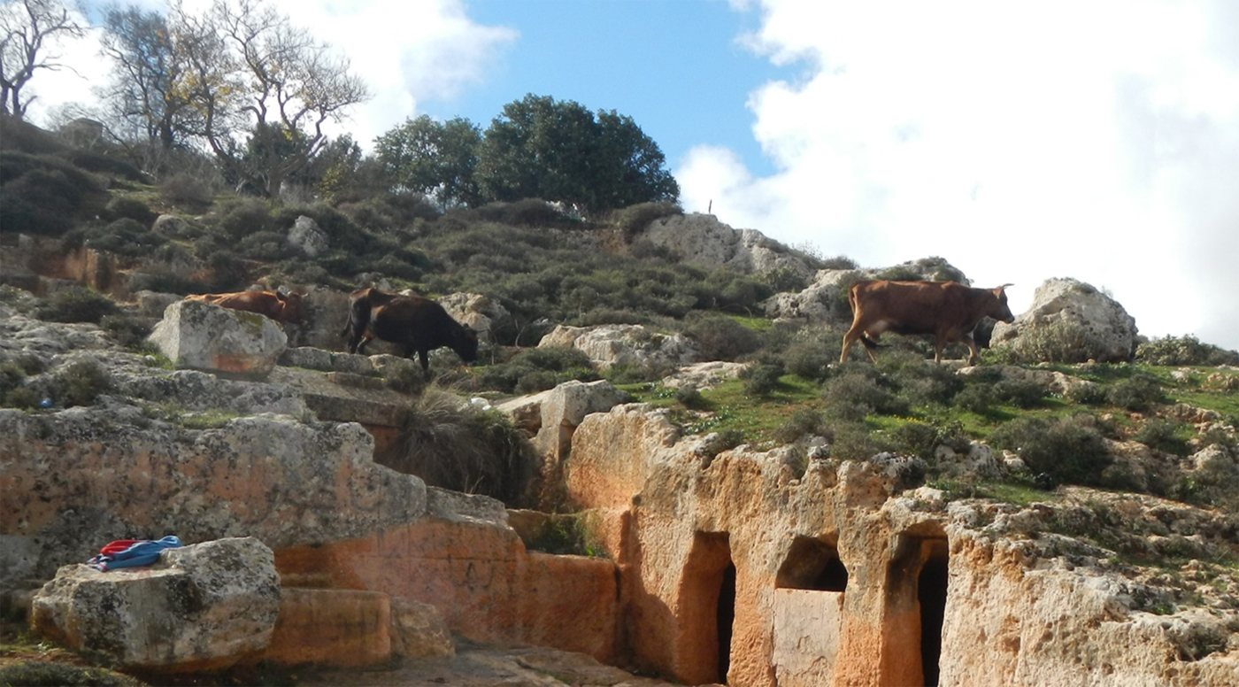
The main risk in Core Zone 2 is the fact that many locals do not consider it as part of the antiquities since it is outside the ancient city and its fences (Core Zone 1). Furthermore, the south-eastern parts of Core Zone 2 are adjacent to New Shahat, which means that quite often people feel authorized to destroy the antiquities because they perceive the areas as natural expansion zones of the modern town, whether there is heritage present or not. Although this area suffered damages during the twentieth century the majority of the destructions happened after 2011, and continue today. Quite often locals demolish tombs with bulldozers to ‘clear’ the area without any authorization, hoping to legalize it later without intervention of the DoA. Looting, vandalism, damages or total destruction to make way for new buildings, and even partial or total removal of some ancient monuments in order to reuse the building materials commonly occur. Further, though the use of some of the monuments, such as tombs and caves, for picnics is important for social reasons, this presents huge risks of vandalism and littering.
Proposed Regulations
Because of the importance of this area, with its heritage, regulations need to be clear and precise.
1. Avoid new building works and infrastructures, except for essential services whose only purpose is to improve the area with non-invasive approaches. All new works must be, as a priority, approved by the DoA.
2. Avoid works or enlargements to existing buildings, except for minor or essential works aimed at improving the area with non-invasive approaches. All new works must be, as a priority, approved by the DoA.
3. Avoid any excavation without the correct permission of the DoA.
4. Avoid the grazing of animal herds on ancient monuments.
5. Avoid aggressive agricultural works on public lands. On private properties the agricultural works must avoid deep plowing (over 40 cm).
6. Avoid having rubbish dumps within the core zone.
7. Prohibit littering, vandalism, damage or graffiti on ancient monuments.
8. Prohibit collection of archaeological materials and objects without proper and legal authorization from the DoA.
Recommendations
1. Check and map structures built recently and establish a committee to consider each case and the best way forwards for safeguarding the monuments involved.
2. Build appropriate new fences and infrastructures for gates and guardian boxes.
3. Organize an efficient service of guardians frequently checking the different areas.
4. Re-organize the archaeological tourist routes and pathways in a more appropriate way, with informative panels and rubbish bins. Future improvement could include the digitization of visitor information (creation of apps, use of 3D reconstructions, virtual reality).
5. Any restoration within the area must be based on international/UNESCO/ICCROM protocols and approved by the DoA.
6. Install appropriate lighting for enhanced display and security.
Notes
The area already has extensive damage and it is crucial that new rules are established to avoid further problems.
CYRENE – Buffer Zone 1A: The chora (territory) of the Greek Colony
Description
The buffer zone 1A has been defined according to the ancient remains, but also the geo-morphological features of the area and the natural territorial limits. This area surrounds core zones 1 and 2 and has an archaeological and natural environment that needs preserving, by limiting the impact of modern buildings and infrastructures.
• Buffer zone 1A has numerous archaeological remains like monumental tombs, ancient farms and quarries and remains of the ancient road network. Most of the remains have never been excavated, surveyed and properly investigated, so they still represent important, and often unknown, contexts, essential to help us understand the history of ancient Cyrene. The preservation of these monuments, within the context of modern buildings and rural areas, is the great challenge for this buffer zone.
• The natural landscape in this buffer zone is particularly rich and variegated and offers a wonderful backdrop to the archaeological remains, now in danger of disappearing.
Risks/Threats
The monumentality of the remains and the importance of the natural context mean that the following risks need to be considered: looting, vandalism, damages or total destruction for new buildings and roads and even partial or total removal of ancient monuments in order to ‘reuse’ the building material.
Proposed Regulations
Because of the importance of this area and its heritage, the regulations need to be clear and precise.
1. Buildings should not exceed 10 meters in height (maximum 3 floors) and low-rise buildings should not be transformed into high-rise flats, which could destroy the impact of the archaeological and natural landscapes.
2. Prohibit the construction of industrial areas or large workshops within the buffer zone in order to avoid the destruction of the archaeological and natural landscapes.
3. Prohibit new quarries which destroy both the archaeological heritage and the natural landscape.
4. Enforce impact studies ahead of any development works, either public or private, for buildings or infrastructures (roads, pipelines, sewers, aqueducts etc.) which should be submitted for approval to a committee of archaeologists and architects of the DoA and of the Baladiyat. The Committee can: 1) give permission; 2) suggest necessary archaeological intervention; 3) refuse the project because it is too dangerous for the heritage. The investigations must be entrusted to archaeologists approved by the DoA and follow the protocols and rules dictated by the Department.
5. Enforce evaluation of the natural/landscaping. A committee of architects, topographers and archaeologists (from the Baladiyat, DoA and possibly consultants from local or international universities) should assess the impact of new buildings or of the construction of new roads on the archaeology and the natural heritage. The same committee should suggest projects relating to the modification of the natural landscape.
6. All excavations to be under the strict control of professional archaeologists, under the direction of the DoA, for every type of work in the area, both public and private.
Recommendations
1. The area must be regularly monitored by inspectors of the DoA and the police.
2. Build appropriate fences where there are monumental remains.
CYRENE –Buffer Zone 1B: the modern city of Shahat
Description
Within buffer zone 1 there is also the urban area of modern Shahat, which includes important parts of the ancient Southern and Eastern necropoleis of Cyrene. Entire sections of the cemeteries recorded by Cassels (Reference Cassels1955; Thorn and Thorn Reference Thorn and Thorn2009) have been destroyed by the construction of the modern city during the last half a century. In buffer zone 1B modern villas, houses and services are built close or even over funerary monuments, which need to be preserved and safeguarded. In the past, numerous remains have been found during building works. But it is impossible to apply the rules for non-urbanised contexts used for buffer zone 1A), and as a consequence a specific buffer zone 1B has been mapped where the ancient remains and the needs of the population need to be considered (carefully) together. Moreover, any new building works in this urban area will bring new finds, making it essential to have some sort of protocol in future.
Risks and Threats
Modern construction works without authorised excavations and/or the involvement of the DoA can seriously endanger ancient monuments, especially those related to the now-urbanized sections of the necropolis. Ancient remains may disappear without correct recording, monuments may be damaged, illegal excavations and looting take place, and monuments may be destroyed. Moreover, high buildings and inappropriate constructions could affect the skyline of the area around the core zones and destroy the architectural impact of the ancient remains on the landscape.
Proposed Regulations
1. Enforce impact studies ahead of any development works, either public or private, for buildings or infrastructures (roads, pipelines, sewers, aqueducts etc.) which should be submitted for approval to a committee of archaeologists and architects of the DoA and of the Baladiyat. The Committee can: 1) give permission; 2) suggestnecessary archaeological intervention; 3) refuse the project because it is too dangerous for the heritage. The investigations must be entrusted to archaeologists approved by the DoA and follow the protocols and rules dictated by the Department.
2. A committee of architects, topographers and archaeologists (fromthe Baladiyat, DoA and possibly consultants from local or international universities) should assess the impact of new buildings or of the construction of new roads on the archaeologyand the natural heritage. The same committee should suggest projects relating to the modification of the natural landscape.
Recommendations
The monuments in this area are partially included within private properties, but they need to be considered as the property of the government and the owner of the land must understand their responsibility to protect them.
Notes
Educating the population about their history and cultural heritage could help in the maintenance of the monuments in this area which has a difficult location being scattered throughout modern quarters. Conferences and meetings with students, cultural associations, school classes, scout groups and different social groups should be regularly organized by the DoA and the Baladiyat. A well educated population could be galvanized into helping the DoA to clean and monitor the monuments.
CYRENE - Buffer Zone 2: the wider territory of the ancient Greek colony
Description
This area of buffer zone 2 (Figures 1–2) surrounds buffer zone 1 and still includes ancient remains. The boundaries were decided on the basis of geo-morphological and topographical features which represent the natural boundaries. It is still very close to the ancient city and to the core zone, and is visible from the core zone A. It is an important section of the suburb and of the ancient chora/territory of the Greek city, with many monumental remains: ancient roads, ancient farms, gsur (fortifications) and tombs. Most of the archaeology in this area is not very well known, because it has been never been properly investigated, surveyed and published. Future research could considerably enrich the historical picture. The closeness to the core and buffer zones 1dictates that the area should be monitored by both the DoA and the Police.
Risks and Threats
The presence of monumental remains in combination with modern farms and buildings, together with its main vocation as area of modern urban expansion, present numerous risks and threats: looting, vandalism, damages or total destruction during the construction of new buildings and roads, and even partial or total removal of ancient monuments.
Proposed Regulations
1. Enforce impact studies ahead of any development works, either public or private, for buildings or infrastructures (roads, pipelines, sewers, aqueducts etc.) which should be submitted for approval to a committee of archaeologists and architects of the DoA and of the Baladiyat. The Committee can: 1) give permission; 2) suggest necessary archaeological intervention; 3) refuse the project because it is too dangerous for the heritage. The investigations must be entrusted to archaeologists approved by the DoA and follow the protocols and rules dictated by the Department.
2. Enforce impact reports on the natural landscape. A committee of architects, topographers and archaeologists (from the Baladiyat, DoA and possibly consultants from local or international universities) should assess the impact of new buildings or of the construction of new roads on the archaeology and the natural heritage. The same committee should suggest projects relating to the modification of the natural landscape.
3. All excavations to be under the strict control of professional archaeologists, under the direction of the DoA, for every type of work in the area, both public and private.
Recommendations
1. Continuous monitoring of the area by the inspectors of the DoA, specifically trained in landscape archaeology.
2. Surveying and mapping of the existing remains and monuments.
3. Adopt preventive excavations during the construction of new buildings and infrastructures.
Notes
The area has not been investigated and may need some excavation and surveys. The construction of new buildings and infrastructures could present such an opportunity, ahead of building: in this way the new constructions could become a positive researches opportunity, instead of just moments of destruction.
Conclusions (O. Menozzi, L. Cherstich, E. Di Valerio, M. G. Di Antonio)
The proposals set out here for the buffer zone system outline a practical model for preserving antiquities and provide the foundations for future discussions amongst institutions, both at local and international level, universities and archaeological missions.
The system was not drawn up simply on the basis of geometric zoning, but included consideration of the distribution and conservation of the monuments and the geo-morphological features of the different areas. The plans began with GIS mapping showing the monuments and their state of monumentality and preservation. Moreover, when possible the widian were used east and west to help outline the buffer zones, while the vertical slopes of the upper and middle terrace were used for the northern boundaries. The southern section of the territory is more problematic, where a specific buffer zone has been indicated at modern Shahat, which is also an area with tombs and remains, sometimes monumental. The southern boundaries of the buffer zone created some challenges, as there is no proper geo-morphological limit and so the decreasing number of archaeological remains and the presence of the main road and the boundary of the local territory of the Baladiyat were used to close off the zone. This limit is also the boundary between the ancient territorial context of Cyrene and the territory of the rural village at Labrak. The rural village formed part of the large territory of the chora of Cyrene, but from amodern point of view, the ancient remains of Labrak must be considered as a different site, with its own core and buffer zone system. This southern limit to the buffer zone of Cyrene, never systematically surveyed, deserves more attention in future.
The zoning strategy also kept in mind the particular needs of the Cyrenean landscape today, especially regarding the dramatic destructions to the heritage since 2011. It is true that the environs of Cyrene, and especially the Necropolis, have always suffered the dramatic expansions of modern development. Nevertheless, the scale and speed of the recent destructions have reached astonishing dimensions. The Libyan technicians from the DoA and the Mission of Chieti University(Abdulkariem and Bennett, Reference Abdulkariem and Bennett2014; Al Raeid et al. Reference Al Raeid, Di Valerio, Di Antonio, Menozzi, AbdalgaderElMziene and Tamburrino2016; Menozzi, Di Valerio et al. 2017; Menozzi, Tamburrino et al. 2017) have sent regular reports about these activities, as shown in the following appendixes. One of the jewels of the ancient Mediterranean, ancient Cyreneis suffering an attack of unprecedented violence, which seems to know no limits. Practical solutions must be sought: the creation of the buffer Zone system is a strong start.
APPENDIX 1
The Western Necropolis: the status of preservation to 2018 (E.Di Valerio)
During the last mission, in 2013 and more recently, according to the DoA Cyrene, surveys took part in the Western Necropolis, in the low course of the Wadi Belghadir and Haleg Stawat. The investigations have been important for identifying and quantifying all the damages caused by tomb raiders and their illegal excavations.
Surveys were possible due to collaboration with DoA officers. The isolated Western Necropolis was monitored and the conditions of the tombs in this area are actually quite good, except for the continuous deterioration caused by the environment.
This survey has identified damage caused by robbing attempts, as well as weathering of the rock-cut surfaces due to atmospheric phenomena and the constant action of the tree roots which, hanging from upper levels, destroy the rock-cut surfaces of tomb façades along the steep necropolis of Wadi Belghadir. There are also signs of vandalism like charcoal graffitos and black marks suggestive of smoke caused by fires started inside the tombs. The isolation of this steep necropolis certainly heightens the chances of vandalism. Furthermore, the area is often looted by robbers looking for statues, which they break in order to transport them more easily.
The following damages have been spotted from the photographs submitted by the DoA. Without geo-referenced positions it is impossible to locate all the damaged tombs in these pictures, but the images highlight the scale of the devastations.
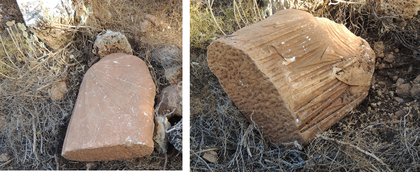
1) Statue of a funerary goddess found during illegal excavations (Figure 3).
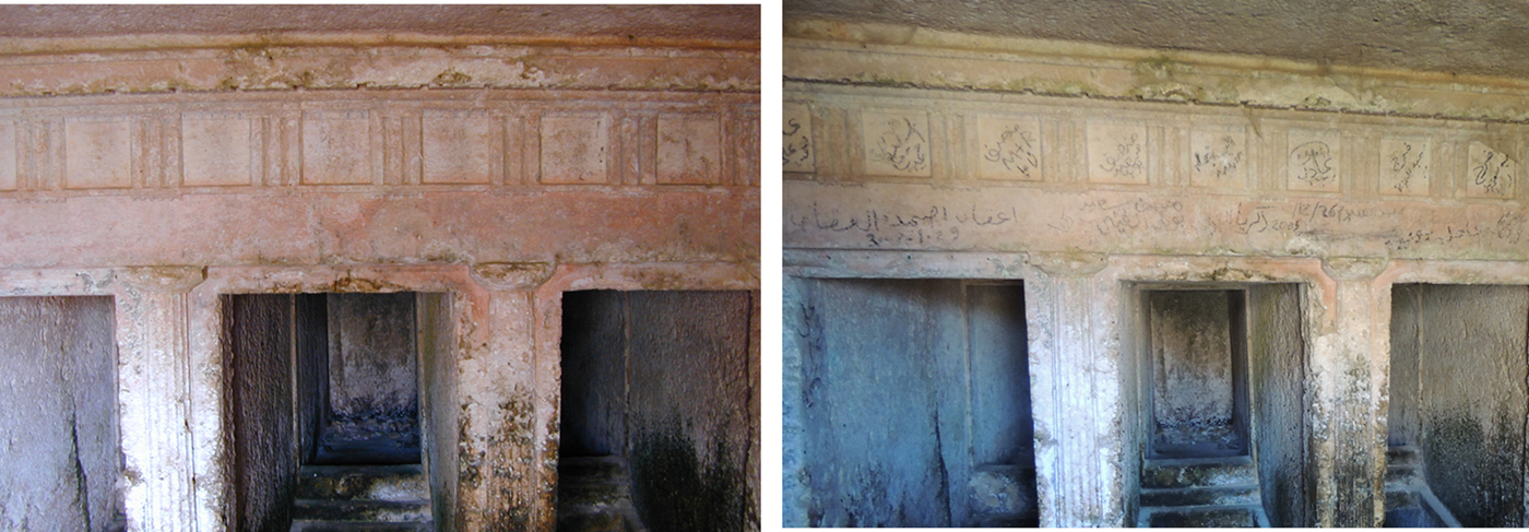
2) Writings over the inner frieze of Tomb W20 (Figure 4).
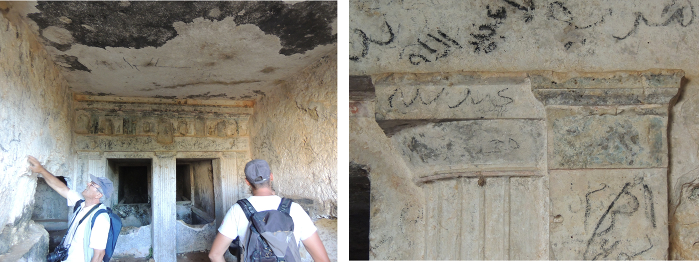
3) Black smoke signs and charcoal graffiti on the inner frieze of Tomb W16 (Figure 5).
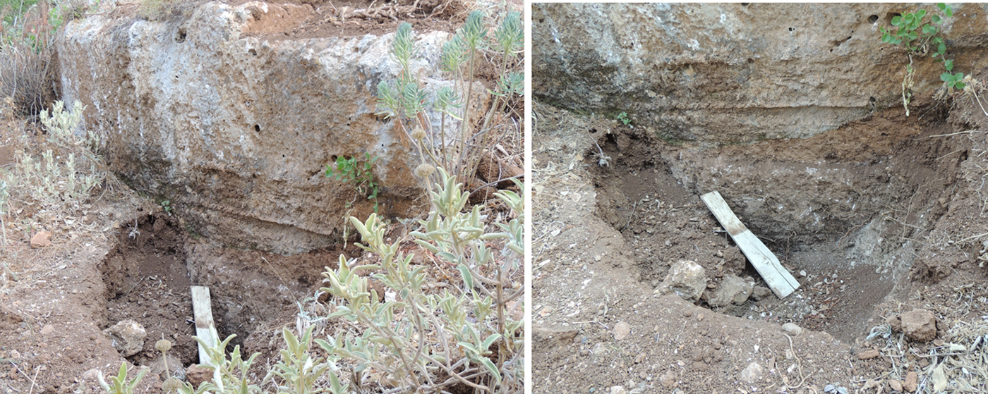
4) Recent illegal excavations nearby Tomb W13 (Figure 6).
5) Recentillegal excavations nearby Tomb W2 (Figure 7).
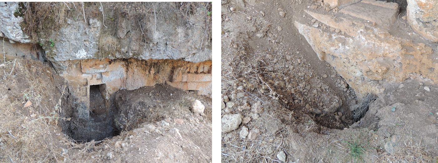
6) Some traces of illegal excavations in front of the façade of this tomb. Fortunately, the architectural decoration on the façade of this tomb doesn't seem to have been damaged (Figure 8).
7) The courtyard of this tomb has been illegally excavated almost completely, uncovering the façade of the tomb, the entrance of a loculus and part of a second loculus. The tomb raiders probably entered through the loculi, perhaps taking pottery sherds or other objects from the funerary assemblages. The architectural decoration on the façade of this tomb doesn't appear to be damaged (Figure 9).
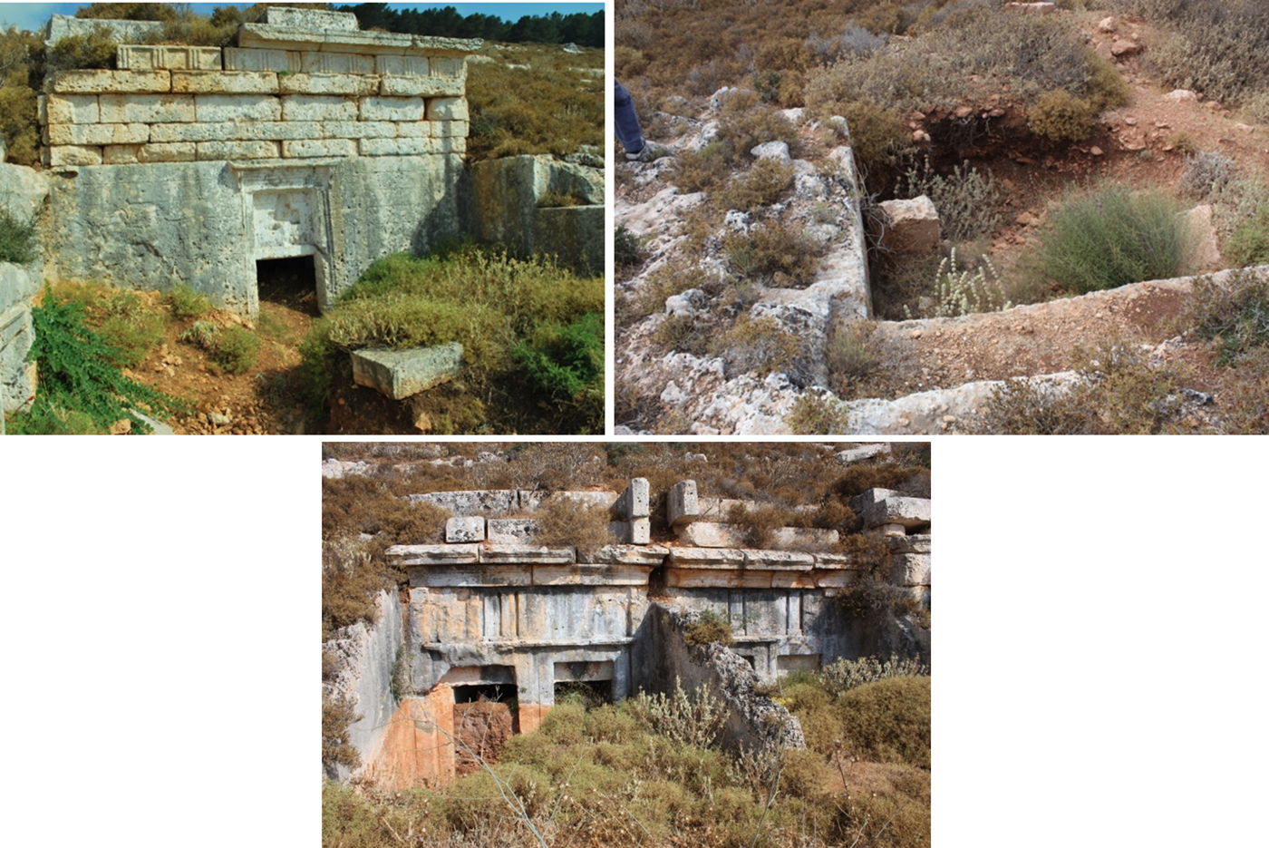
8) Unfortunately, this tomb has suffered many damages. Illegal excavations have been carried out inside the loculi, and sadly all the architectonic decoration of the façade has been completely removed, destroying the frieze and making it impossible to reconstruct the original ornamentation. The tomb raiders probably entered through the loculi, perhaps taking pottery sherds or other objects from the funerary assemblages. (Figure 10).
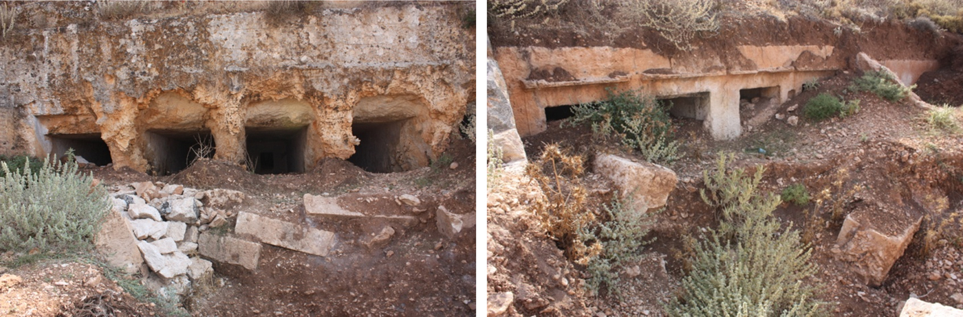
9) The courtyard of this tomb has been illegally excavated, uncovering the top portion of the façade of the tomb and the entrance of three loculi. The tomb raiders probably entered through the loculi, perhaps taking pottery sherds or other objects from the funerary assemblages. The architectonic decoration on the façade of this tomb doesn't appear to have been damaged (Figure 11).
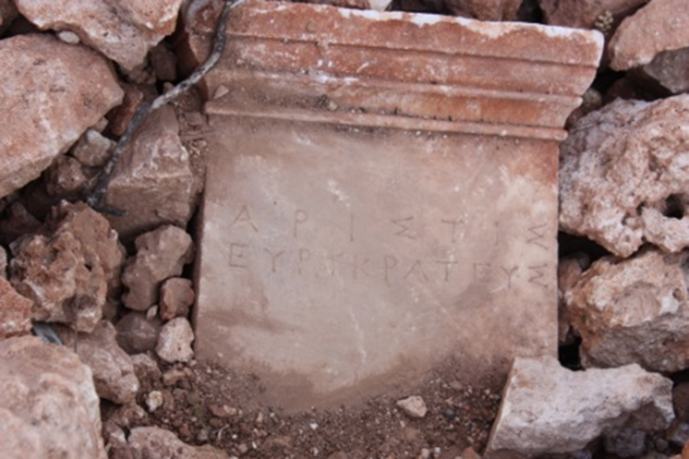
10) The courtyard of this tomb has been illegally excavated, uncovering a portion of the façade of the tomb and the entrance of three loculi. The tomb raiders probably entered through the loculi, perhaps taking pottery sherds or other objects from the funerary assemblages. The architectural decoration on the façade of this tomb doesn't appear to have been damaged. In front of the façade our team has found a beautiful and interesting Greek inscription on marble (Figure 12).
Cyrene, Western necropolis: the funerary statue which has been found during the survey of a tomb which has been excavated by clandestine robbers (by Eugenio di Valerio, Archive of the Archaeological Mission of Chieti University in Libya).

Cyrene, Western necropolis: views of the tomb W20 with painted Doric frieze (by Eugenio di Valerio, Archive of the Archaeological Mission of Chieti University in Libya).

Cyrene, Western necropolis: views of the tomb W16 with painted Doric frieze (by Eugenio di Valerio, Archive of the Archaeological Mission of Chieti University in Libya).

Cyrene, Western necropolis: recent illegal excavations nearby Tomb W13 (by A.Abdalrahim Shariff Saad, Archive of the Archaeological Mission of Chieti University in Libya)

Cyrene, Western necropolis: recent illegal excavations nearby Tomb W2 (by A.Abdalrahim Shariff Saad and Eugenio di Valerio, Archive of the Archaeological Mission of Chieti University in Libya).

Cyrene, Western necropolis: Recent illegal excavations (by A.Abdalrahim Shariff Saad, Archive of the Archaeological Mission of Chieti University in Libya).

Cyrene, Western necropolis: damaged and looted tomb (by A.Abdalrahim Shariff Saad, Archive of the Archaeological Mission of Chieti University in Libya).

Cyrene, Western necropolis: the courtyard of this tomb has been illegally excavated, uncovering a portion of the façade of the tomb, the entrance of three loculi and in front of the façade a marble Greek inscription has been found (by A.Abdalrahim Shariff Saad, Archive of the Archaeological Mission of Chieti University in Libya).

API∑TI∑
EYP-KPATEY∑
APPENDIX 2
The Southern Necropolis: brief remarks on the tragic destructions up to 2018 (L. Cherstich)
The present author wrote a doctoral thesis on the Southern Necropolis of Cyrene (Cherstich L. Reference Cherstich2006a, Reference Cherstich2007, Reference Cherstich2008), stemming from research performed as part of the activities of the Italian Mission of Chieti University. The last visit to Cyrene for this research was in 2008. Since then, however, the Italian Mission of Chieti has been sent reports and photos by members of the DoA (in particular Farag Abdel Hati and Abdalrahim Sheriff Saad) and their work has been crucial in the writing of this paper.
This appendix provides a list of the most significant destructions in the Southern Necropolis over the last few years (there is not enough space here to include all the details or geo-referenced positions for each incident). Nevertheless, this list gives a sense of the scale of the problem in the Southern Necropolis today. All tomb names use the system established by Cassels (Reference Cassels1955) while GPS names refer to the codes in Cherstich Reference Cherstich2007.
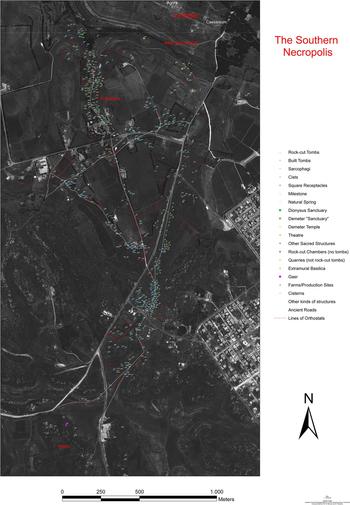
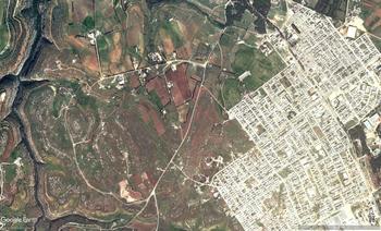
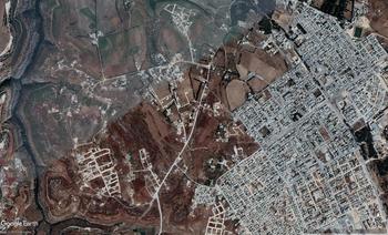
To have a general sense of what has happened over the last 10 years, my research up to 2006 outlines the archaeological monuments present during that period (Figure 13). If you then check the satellite imagery, comparing photos from ten years ago (Figure 14) with the what is visible in 2018 (Figure 15) (using Google Earth Pro software, images © 2018 Digital Globe), the scale of the destructions becomes immediately clear.
Survey of the Southern Necropolis up to 2006 (Cherstich Reference Cherstich2007; satellite image: University of Chieti).

Google Earth satellite image of the Southern Necropolis, 29th March 2009 (© 2019 Digital Globe).

Google Earth satellite image of the Southern Necropolis, 22nd June 2018 (© 2019 Digital Globe).

Without survey on the ground, it is impossible to evaluate the exact number of lost monuments, nevertheless it is clear that whole chunks of the ancient landscape, miraculously preserved for centuries, have been deleted by bulldozers in just a few years. The Southern Necropolis is one of the most tragedy episodes in the history of Libyan heritage.
The first images (Figures 13, 14) show a situation similar to my 2006 survey. Huge parts east of the Balagrae Road were already lost but, at least, the destructions did not stretch to the areas west of the ancient road, due to an apparent slowdown of expansion. In 2006 the modern presence was limited to a few houses, some temporary shacks and very rough, almost ineffective fences made of spiked wire and wooden poles. Many families used ancient tombs as storerooms, stables or even garages: the DoA was constantly trying to protect these tombs and limit the damage, but they had limited resources. Thus, in 2006 many tombs, especially along Balagrae Road, were empty.
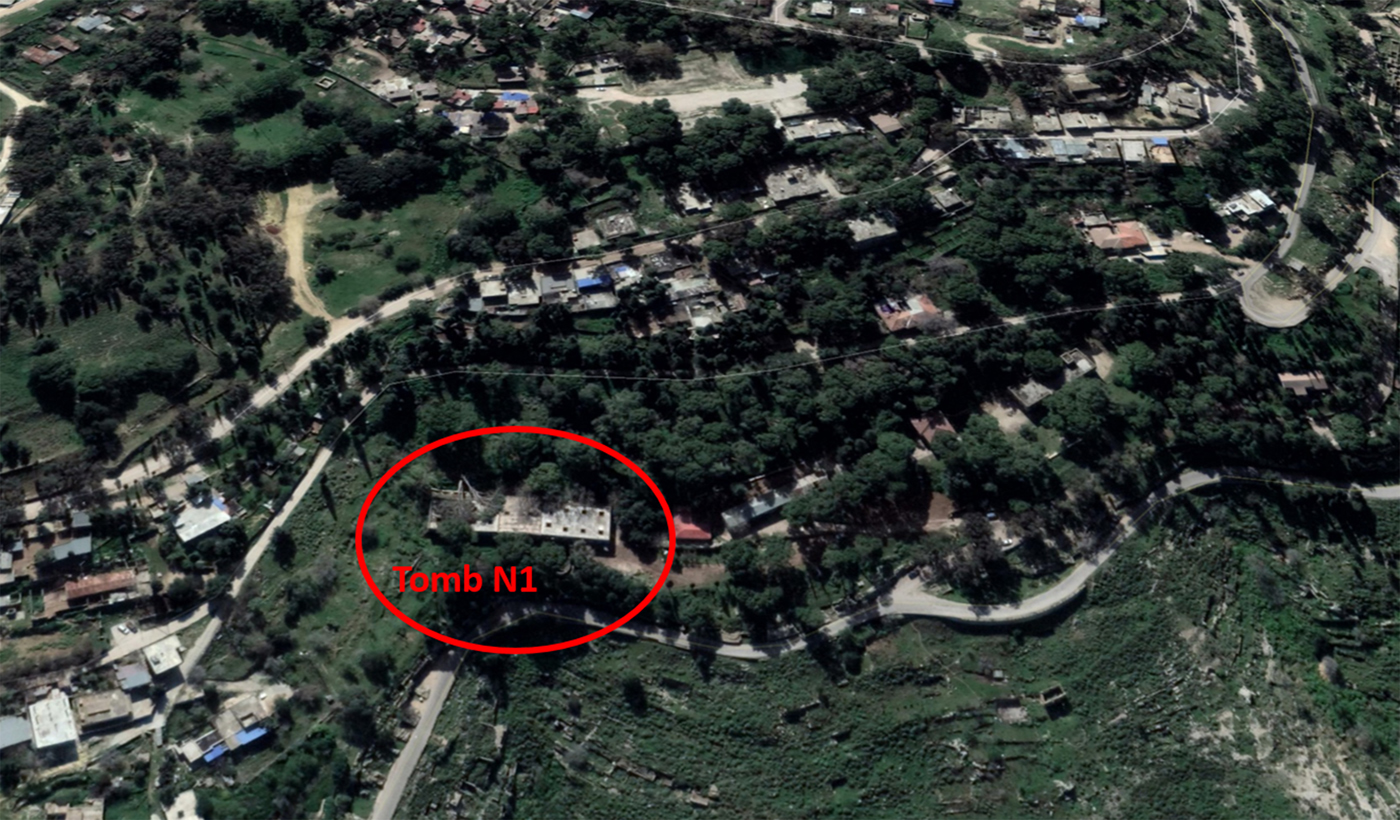
The second image (Figure 15) shows a devastated landscape. The many new buildings in the 2018 satellite image seem to be expansions of the old shacks, while large concrete fences have replaced the iron wire ones. Many local landowners took advantage of the lawless situation following 2011 and enlarged areas they were already misusing and the number of vandalized and destroyed tombs dramatically increased. Members of the DoA report how whole areas in El-Baggara (the Southern Necropolis) have been cleared of antiquities by bulldozers, with the plots being sold for building. The regular shape of many of the new roads, visible in the photos, shows new plots for an illegal land development (Figure 15).
What follows now is a brief summary list of some of the possible damages, as registered by the photos and reports from the DoA technicians.
• Tomb S2 (GPS 14 in Cherstich Reference Cherstich2007; Thorn and Thorn Reference Thorn and Thorn2009, 206) was an interesting monument: an isodomic-built tomb with a rock-cut loculus chamber with loculi opening off a central corridor. This monument possibly dated to the Late Hellenistic period. It has never been properly investigated and before 2006 drawings were made without proper cleaning. The fate of this monument is unknown since it looks like a large modern building has just been built nearby (Figure 16), possibly destroying all the ancient remains.
• The modern cemetery with the old Marabout of BouBagiuda (now unfortunately destroyed, see Menozzi et al. Reference Menozzi, Di Valerio, Tamburrino, SalehShariff, d'Ercole and Di Antonio2017) has always been the site of the monumental Late Hellenistic Tomb S4 (GPS 16 in Cherstich Reference Cherstich2007; Cherstich Reference Cherstich2006b). There has been no construction at the cemetery but a small half-figure, possibly dating to the fifth century BC, was found during construction works nearby (see O. Menozzi, this article). The exact position of the find is unknown, although there are many new buildings west of the cemetery, as well as new structures to the south. I previously identified an Archaic/Early Classical land-division system with a sixth to fifth century BC tomb every 450–500 m (Cherstich L. Reference Cherstich2008, 75–8; Cherstich et al. Reference Cherstich, Menozzi, Antonelli and Cherstich2018, 124–6), a rare piece of evidence for land-divisions between the colonists of the first phase. The cemetery should have hosted Archaic/Early Classical tombs but none were known: this new find, potentially dating to the fifth century BC, could potentially fill that gap in our knowledge. Nevertheless, since the original context was recorded and the original tomb has probably been destroyed by the builders, the chance for further investigation is lost.
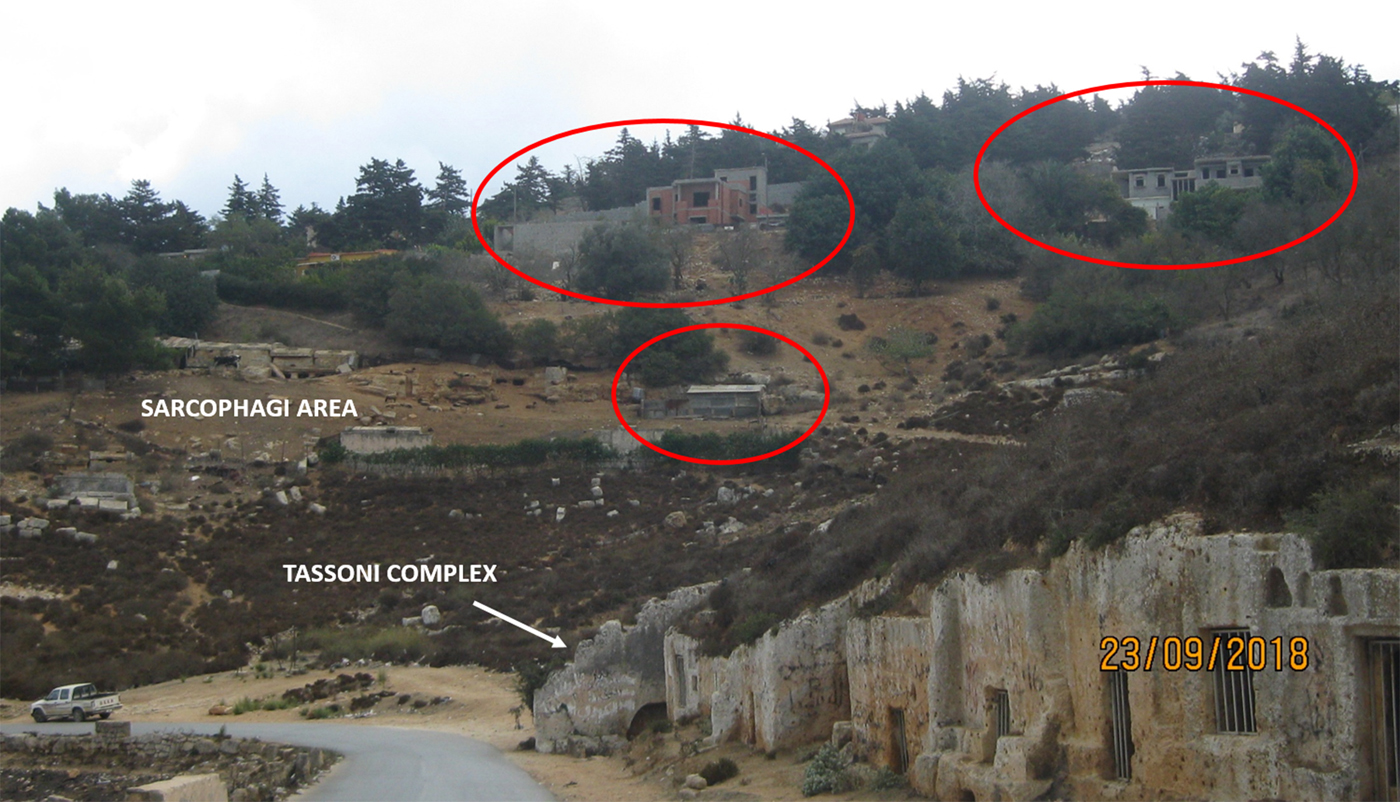
• The asphalted road running parallel to the Balagrae Road probably sits on top of an ancient pathway, possibly Late Hellenistic (the ‘redoubling’ in Cherstich Reference Cherstich2007), with galleried-loculus chamber tombs along it – put to use when all the available space for tombs along the nearby Balagrae Road was full. In 2006 this was still a piece of ancient landscape which demonstrated the continuous competition for funerary ostentation in Cyrene. The western side of the asphalted road hosted a series of at least 12 different rock-cut with sunken courtyards, sometimes with fallen false façades: Tomb S7 (GPS 33), Tomlinson 1004 (GPS 32), S8 (GPS 31), S9 (GP 30), S10 (GPS 29), S11 (GPS 27), Beschi's S11bis (GPS 28), S12 (GPS 23), S13 (GPS 22), Tomlinson 1013 (GPS 24), GPS 25, GPS26 (Thorn and Thorn Reference Thorn and Thorn2009, 208–212). Today you can only see a concrete wall, standing exactly where the tombs should be (Figure 17). The fate of these tombs is unknown, as the available satellite imagery show a blurred view, although the presence of some buildings may attest the destruction of at least some of them.
• On the other side, the ancient Balagrae Road, which used to be one of the most beautifully preserved ancient roads around Cyrene, has been perpendicularly cut by an imposing concrete wall (Figure 18), just north of Tomb S66 and S67 (GPS 40–41 in Cherstich Reference Cherstich2007; Thorn and Thorn Reference Thorn and Thorn2009, 221). The barrier is straight and dangerously close to a Roman milestone (Goodchild Reference Goodchild1950, 85), interfering with, covering or blocking the view of at least five tombs: S62 (GPS 34), S63 (GPS 35), S64(GPS 36), S65 (GPS 38) and GPS 39 (Thorn and Thorn Reference Thorn and Thorn2009, 220). It is impossible to know the fate of these monuments but the presence of many modern buildings within the wall clearly demonstrate that some serious damage has occurred. Tomb S64 (GPS 36) was particularly significant since it hosted unique Late Hellenistic illusionistic wall paintings (Cherstich and Santucci Reference Cherstich and Santucci2010), roughly comparable with the so-called Pompeian Second Style, but which clearly demonstrate the dialogue of the Cyrenaican funerary world with Alexandria. These wall paintings are unique in Cyrenaica, and are important within the wider perspective of the history of the Ancient Eastern Mediterranean. Given the old habit of vandalizing or white-washing tomb interiors there is a serious risk that this treasure is now lost.
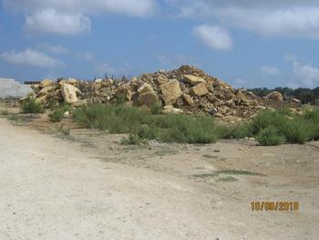
We cannot know more without visiting the area, but the photos taken by members of the DoA include many modern buildings, heaps of blocks from destroyed monuments (Figure 19) and indications of plot division and sale.
Modern building in the area of Tomb S2, facing south (Photo 2018: A.Abdalrahim Shariff Saad, S. Farag Abdel Hati).

Modern buildings in the area of Tombs S11, S11 bis and S13, facing north (Photo 2018: A.Abdalrahim Shariff Saad, S. Farag Abdel Hati).

Modern wall cutting Balagrae Road and Modern buildings in the area of Tombs S63 and S64, facing north (Photo 2018: A.Abdalrahim Shariff Saad, S. Farag Abdel Hati).

Heap of isodomic blocks and orthostats from a destroyed tomb in Baggara (Southern Necropolis) (Photo 2018: A.Abdalrahim Shariff Saad, S. Farag Abdel Hati).

This article cannot show all the destructions, which are extremely numerous, as the satellite imagery demonstrates (Figures 13, 14, 15). New roads have been opened and buildings have appeared everywhere. The Southern Necropolis is clearly one of the main victims of the recent destructions. Furthermore, these destructions are not slowing down, even when member of the DoA try to stop them.
The main problem is that the Southern Necropolis is not only close to the modern city of Shahat, but is also flat and sited along a natural connection between Shahat and Al-Bayda, which means that it is an attractive place for potential developers. A solution must be found before this amazing archaeological landscape is lost forever: a tragedy not just for Libya, but for the whole world.
APPENDIX 3
A small statue of a funerary goddess from Baggara (O. Menozzi, A.Abdalrahim Sheriff Saad and M. Belzic)
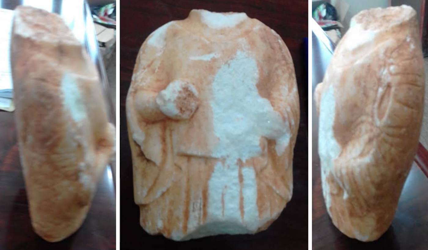
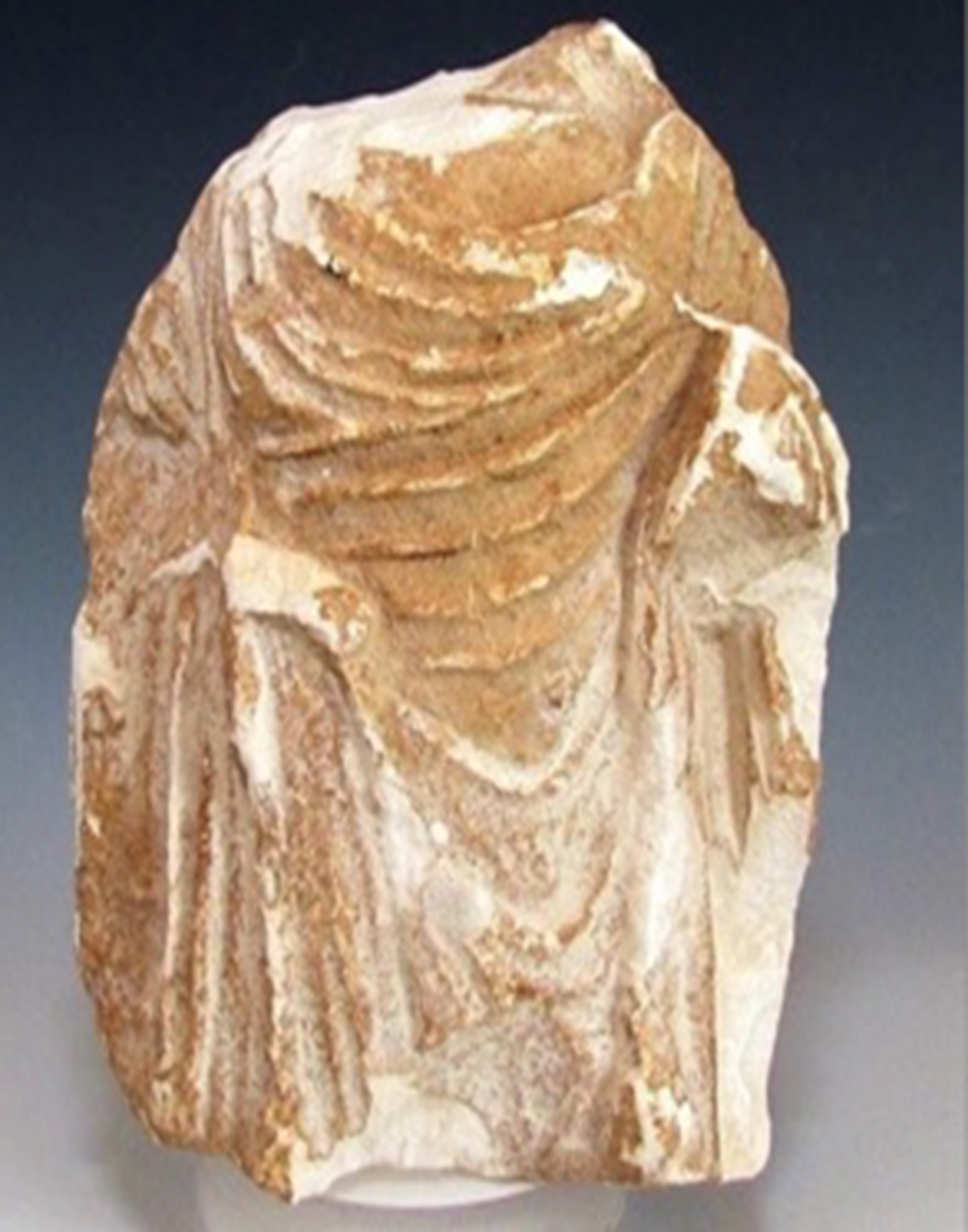
The small statue, found by Mohamed Salem Omar El Alhasi, is very interesting and representative of a very rare typology of Cyrenaican funerary goddesses (Figure 20). The type is known at Cyrene through examples from other necropoleis of the ancient site. The type was in origin a local chthonian/kata-chthonian deity, which must have been used originally as a marker of the tombs. It was probably very stylized in earlier periods, made from wooden and stone life-size stele. In the Late Archaic period these became female funerary busts, originally cut just below the shoulders and then slowly under the armpits and later under the hips. The local female goddess was then syncretised, with a gradual Hellenization, with Persephone/Kore, assuming the iconographic schemata of Demeter and Kore. The earliest types, according to the typology of Beschi, date back to the Late Archaic period and are characterized by a ‘lithic version’ of poles, dressed up with a simple vest, a chiton or peplum, without any himation (mantle) and wearing a wavy curly wig, to shoulder level. For a long period, a common feature for these statues was the ‘aprosopy’, that is the complete lack of a face, presented plain and without any indication of a mouth, nose and eyes.
Views of the statuette: front and sides (photo by A.Abdalrahim Shariff Saad).

Looking at the typological groups, the first group, types A, B and C, seem to date to the sixth and fifth centuries BC and they represent variations of the same typology, without any substantial difference. Type A presents busts cut at the shoulders, with no arms and they are not veiled; according to the hair style, they can be dated to the Late Archaic period. Type B busts are a bit taller, cut below the armpits and arms, and the hands are, for the first time, represented, although still roughly. The type C statue goes from head to belt level and sometimes further, with similar iconographic schema, and wears, above a more pleated chiton (top), a short and plain himation (mantle). This type, according to the top and mantle, and the hair style and iconographic schema, seems to date to the fifth century BC. Type D represents a transitional step to the second group, though remaining in the first: the mantle is realized as a large himation, wrapping the body and presenting folds.
The second group of statues, types E, F, G and H, presents statues veiled with the himation, covering head, shoulders, and the lower part of the body, but leaving uncovered the upper part of the bust. The iconographic schema is very well known, because it is the typical attitude of weeping figures (Lullies and Hirmer Reference Lullies and Hirmer1957, 84–86, pls 207–209): one arm bent at the height of the belt and the second either raised to the cheek in a gesture of sadness (H),or holding a piece of the veil (E, F, G) as if to reveal the face, in a gesture of the anakalypsis. This second group seem to belong mainly to the fourth century, as attested by the rendering of the folds of dress and mantle and by the treatment of the hair.
The third group (types I, L, M, N, O, P) dates to the Hellenistic period, presenting a proliferation of new sub-types and variations. The figures are represented up to the hips, the head is veiled, the himation completely wraps the upper part of the figure with rich and soft folds and part of the face is visible. The statues also show features of the face, such as the mouth, nose and eyes, but without any specific physiognomic characterization.
The fourth and last group of Beschi (Q, R, S, T, U, V) is not a proper homogeneous group, but is mainly statues which are not easily fitted into groups1–3, being a sort of hybridization of types or simply different.
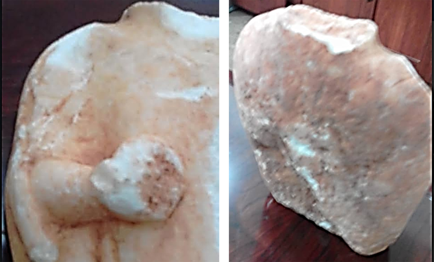
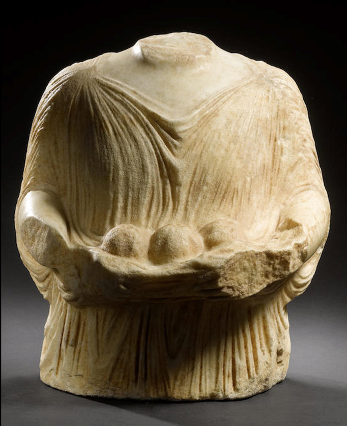
Within this typology, the small marble statue, the subject of this appendix, which was recently found at Baggara (Figure 20) belongs to Beschi type C and seem to date to the fifth century BC. It is just 8–9 cm tall (but originally taller) and 4 cm wide, and presents the figure from the hips. The head, the left forearm and hand are lost. The rest of the statue is well preserved, other than very recent damage to the frontal part and the neck. It is made of white marble, probably Penthelic, pure white, with thin crystal grains and an opaque patina, reddish in colour due to the oxidation of the local iron-rich earth. The female figure is presented, as usual, standing, with front-facing features, and is wearing a large chiton (top) with deep parallel folds in the lower part of the body, which seems quite rigid. A short, thick and plain mantle covers both shoulders and the upper part of the bust. The mantle is held onto the shoulders by little loops and the frontal part, on the breast, could be part of the mantle itself or a kolpos of the top (generally quite typical of the peplum and not of the chiton) or even a short apoptygma. What is left of the neck suggests that the head was not veiled and the neck was nude, so the statue was not wearing a long wig or hairstyle. The left hand was bent, but the forearm is lost and it is therefore difficult to understand the real meaning of the gesture. On the contrary the right arm is bent and the hand holds a pomegranate (Figure 21), which is a typical attribute of Kore and Demeter. It can be compared to bust no. 6 of Beschi's catalogue, bearing the same attribute, dated around the first half or the middle of the fifth century BC. Attributes are quite rare in this class; quite often, they only have snake-bracelets on the arms. But between the end of the sixth and the fifth centuries sculptors tried to develop the style of the first group of sculptures: alabastra (perfume vase, three sculptures), taenia (ribbon, only one) and pomegranates. A sculpture sold on the art market by Bonham's in London in October 2016 shows three of them between the hands (Figure 22).
The right hand of the statuette with the pomegranate; back side of the statette (photo by A.Abdalrahim Shariff Saad).

Funerary goddess sold by Bonhams, London, 28 October 2009, lot n°205 (photo after M. Belzic).

Returning to the small statue, the figure (Figure 21) is very roughly finished, probably because the back side was not visible when on display. However, it presents remains of two arms, as if the statuette was re-sculpted on an earlier small figure, reusing the back of the earlier figure, which was probably from the same category. A very particular feature of this statue is its size (when complete it was not more than 10/12 cm tall). It is a very small version of the typical funerary goddess from Cyrene and its location within the funerary monument explains why similar small statues are rarely found: most of the funerary goddesses currently found and published are much larger and thus more visible and are often found lying on the ground, but as very few archaeological investigations have been carried out in the necropolis, the small versions are rarely discovered. During Rowe's exactions in the 50s, (Rowe Reference Rowe1959), at least 16 sculptures, fragmentary, were discovered in the zone of sarcophagus and rock-cut tombs N.81–83; and with one exception (Beschi no. 15), they were all no more than 30 cm tall, in limestone or clay (Beschi Reference Beschi1972, fig. 6).We know only one other funerary goddess statuette of this size. Sadly, it was sold on the art market in Jerusalem by the gallery Biblical Artifacts, along with a funerary portrait stolen in Derna in 2005. Its measurements are 13.2 cm high, 12 cm wide. But the type is quite different, belonging to Beschi's third group, type P, probably dating to the Hellenistic Period (Figure 23).
Funerary goddess from Cyrenaica, on sale in Jerusalem in 2016. H. 13.2 cm. Marble. Beschi's type P (photo after M.Belzic).

There are four possible locations for our statuette, which explain the size and the unfinished back. A first possibility is that it could have been located within the niche of a small free standing naiskos: in this case it could have been a small funerary monument along a road, but not specifically related to a tomb. At Cyrene these types of monuments are rarely attested, especially for the sixth and fifth centuries BC, and is therefore quite difficult to find parallels. However, the measurements of the statuette seem to belong to a naiskos rather than to the façade of a tomb. As a parallel, Beschi (Beschi Reference Beschi1972, 320–321 fig. 115) published a statue of Kore, quite similar to the Cyrenaican funerary statue, with the attribute of a pomegranate, as here, coming from Durres (now in Vienna), which was located within a funerary naiskos with a similar function to the statues in Cyrene.
A second possibility is a location within a niche, but on the façade of a tomb, for instance in a niche on a naiskos type façade of a rock-cut tomb, as attested for instance for larger funerary statues belonging to the Late Archaic and Classical periods. Tomb W152, in the Western Necropolis, presents a naiskos façade with a niche for a funerary statue within the pediment. In this case the statue of the funerary goddess is lost, but the shape of the niche suggests that the statue is type A or B: a bust cut at the shoulders or armpits. The dating of these typologies is Archaic/early Classical. Another rock-cut tomb with niches for funerary statues is the type with a false portico and lintels with acroteria (Thorn type C and see Di Valerio, this volume), for example tomb W22. In this case the shape of the niche (the statue is missing) suggests a funerary goddess type Beschi D, completely covered by a large himation, and therefore dating between the middle and the end of the fifth century BC. Similar niches can be observed on the facades of tombs W151, S193, N8 and on the Beschi Tomb near the N196. The size of the statuette, however, seems to be too small for a tomb façade and small niches are attested on the facades of the monumental tombs at Cyrene in Roman times, belonging to the Romano-Libyan funerary portraits.
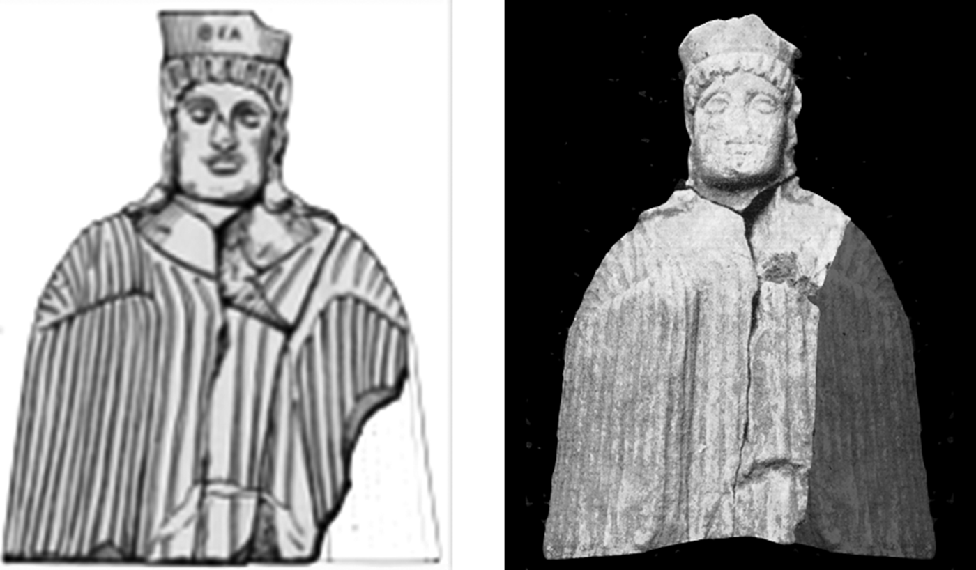
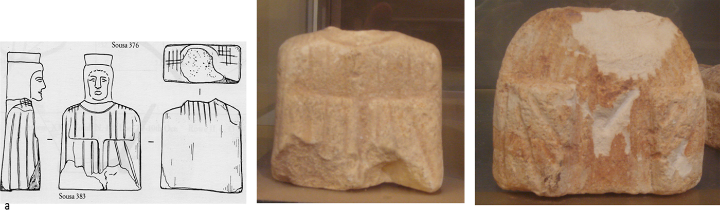
A third possibility for the location of the statuette is on top of a sarcophagus, as suggested for the statuette (inv M 1185) found by Alan Rowe (Figure 24) and recently drawn and published by Thorn (Reference Thorn2005, fig. 6). This example comes from the Northern Necropolis (courtyard of N81, N81KK), and was found during the excavation by A. Rowe and represents an earlier version. It has a very frontal impact and the back is completely plain. It is wearing a top or mantle, which completely covers the arms. The face is very frontal, with a very curly hair style and a polos (a plain crown) on the head. According to Thorn it was located on a sarcophagus, maybe N81-RR, and was finished only on the frontal, visible part. The only problem in this case is the stratigraphy, related to an enclosure of sarcophagi dating to the fifth century BC, but also reused later, so the dating is little unclear. The small statue was partially published by Beschi (Reference Beschi1972, 220, no. 13, fig.6b). According to Beschi it dates to the end of the fifth century BC, but it could be earlier. It is characterized by a long himation, completely covering the body, including the hands but not the head, and is therefore an example of the Beschi's type D. Another example, now in Sousa Museum (Figure 25), comes from the courtyard N 83-S (Thorn Reference Thorn2005, fig. 333). A third is also in Soussa but without known provenance. The examples from the N81, N 83-S and in Soussa both date to the fifth century BC, but are still very Archaic in style, probably due to the conservative tradition of the local workshops. These statuettes measure between 24 and 30 cm, so a little taller than the example from Baggara.
Statuette (inv M 1185) which has been found by Alan Rowe; Funerary Goddess from Cyrene, N 81 KK. Left: Drawing by J. Thorn. Right: reconstruction, after Beschi's illustration, by M.Belzic.

Funerary goddess in Sousa Museum. Left: drawing by J. Thorn. Centre: photo by M. Belzic after S. Marini). Right: unknown provenance, Cyrene or Apollonia, (photo by M. Belzic after S. Marini).

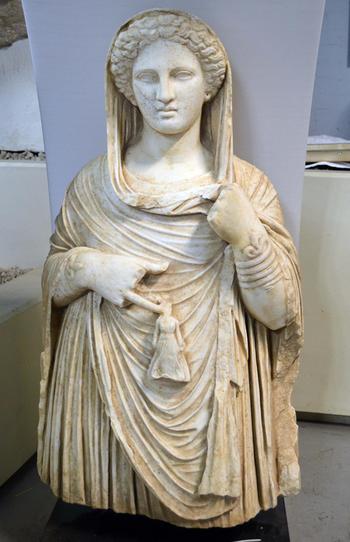
A fourth possibility is that the statuette was a representation of Kore as part of a more complex representation, with a small Kore/Persephones on one hand of a larger Demeter, representing the anodos of Persephone coming back from Hades and helped by her mother. In this case the back of the statue was unfinished because it was not visible, and laid on the bust of Demeter. This kind of composition can be found for instance in the statue which was recently recovered from the black market and is at the moment in the British Museum (Figure 26), waiting to go back to Cyrene (see https://www.telegraph.co.uk/news/uknews/law-and-order/11503807/Court-sits-at-British-Museum-for-first-time-as-judge-studies-looted-Libyan-sculpture.html – accessed June 2019). The statue is life-size, cut below the hips, as if emerging from the underworld and bringing with her a small statuette, possibly Persephones in her anodos. The representation is also quite evocative for the role of these funerary goddesses as supporting the souls on their journey, having a function similar to that of a psicopompos god. This statuette is in low relief and is not free standing. The iconographic schema, as well as the treatment of the himation suggest that it is slightly later than the one from Baggara and therefore this fourth possibility is less likely.
Funerary goddess seized in 2013 in Great Britain (photo by M. Belzic).

It is quite difficult to say which of these possibilities is the most plausible, particularly as this statuette is rare, typologically. However, its casual discovery along the road suggest that there is a large quantity of funerary finds in the ancient suburb of the site, stressing the need for the necropolis to be monitored constantly. On the other hand, it is encouraging that the boy who found the statuette went directly to the DoA because he understood that it was an important part of his cultural heritage. Conferences, meetings and small exhibitions should be organized for schools in order to further improve this consciousness that their patrimony, currently in danger, could be lost for ever.
APPENDIX 4
The Northern Necropolis: the status of damages up to 2018 (M.G. Di Antonio)
Cyrene offers one of the largest and most spectacular necropoleis of the Mediterranean, however, its size makes it difficult to monitor and protect. An extraordinary patrimony of rock-cut architecture was carved around the ancient site, but this has now becomes a zone at major risk of damage and destruction as a result of continuous looting and vandalism.
The Northern Necropolis is certainly the best-known area in Cyrene from an architectural point of view, since most of the monuments are rock-cut, with many tombs whose life spans extend from the sixth century BC until at least the fifth century AD. It embraced a wide range of structural types such as rock-cut chamber tombs, monumental built tombs and upstanding sarcophagi (Cassels Reference Cassels1955; Thorn Reference Thorn2005). Many tombs were excavated during the nineteenth and twentieth centuries, but others have been looted over a long period of time.
The vastness and the monumentality of the area made suggested the need for a systematic project: this was started by the Chieti University Team in 2004. Survey, excavation and GIS mapping were carried out in three seasons (2011, 2012 and 2013) by a joint team of the DoA and Chieti University to map and evaluate the damages. The results have already been presented in preliminary reports attesting the looting of many tombs (Mziene and Al Raeid Reference Mziene and Al Raeid2015; Al Raeid et al.Reference Al Raeid, Di Valerio, Di Antonio, Menozzi, AbdalgaderElMziene and Tamburrino2016).
The situation after 2011 changed rapidly: a lack of control increased these issues, which reached maximum intensity between 2014 and 2015. The situation is tragic, especially for the large necropoleis surrounding Cyrene. Due to its landscape, the Northern Necropolis is possibly less prone to the vast destructions which the Southern and Eastern cemeteries have suffered, but many tombs are located very close to modern Shahat, and are often vandalized, destroyed or heavily damaged.
Several damages have been mapped, mainly caused by looting in the remote sections of the necropolis. Robbery and damages in uncontrolled sites or monuments have always been a big problem in Libya, especially because the younger generations did not properly understand or care about their own past, and too often archaeology was seen by them as a problem for new buildings, or as a source for illegal earnings.
Vandalism is a real problem, and the phenomenon includes many different kinds of damage, from charcoal writing, graffiti and spray colours, to the partial or total destruction of a monument. The main cause of such problems is the asphalted road running through the Northern Necropolis directly towards Apollonia. During the week, many people coming from outside stop near the monuments to have picnics and light fires for tea, and they leave their rubbish when they go home.
Other kinds of damage arise from animal grazing (Figure 27) in the archaeological areas and the wild vegetation (Figure 28) that irreparably attacks the monuments from both the outside and the inside, especially in the case of painted tombs (Menozzi and Tamburrino Reference Menozzi and Tamburrino2012) or tombs with mosaics.
Northern necropolis: uncontrolled animal grazing (Photo by author).

Northern necropolis: Tomb N1 covered by wild vegetation (Image © 2019 Maxar Technologies - © Google 3/10/2019).

An important step forwards in the last few years has been the use of remote sensing and photo interpretation analysis to map the damages of urbanization and modern construction in the areas of the necropolis. This project is still ongoing and consists of surveys and remote sensing analyses based on numerous satellite images regularly taken over the past four years. During the last five years it has been impossible for the Italian Mission to work in Cyrene; nevertheless, the Libyan members of the joint team continued the fieldwork in close contact with their Italian colleagues. In fact, as a result of the continuous monitoring by remote sensing and photo-interpretation, new critical areas affected by uncontrolled urbanization, vandalism and looting were spotted, and our Libyan colleagues at the DoA were immediately informed (Menozzi and Di Antonio Reference Menozzi and Di Antonio2018). Thanks to this system of prompt notification, they were able to visit the sites at risk, to monitor the development of the situation, in several cases even to stop the bulldozers and, when appropriate, to excavate and document the site.Footnote 9
The long and systematic mapping and remote sensing of the necropoleis has already produced a series of reports, some of which have been published in Libyan Studies (Al Raeid et al. Reference Al Raeid, Di Valerio, Di Antonio, Menozzi, AbdalgaderElMziene and Tamburrino2016) and in Libya Antiqua (Menozzi, Di Antonio, Di Valerio Reference Di Valerio2015; Mziene and Al Raeid Reference Mziene and Al Raeid2015; Petraccia et al. Reference Petraccia, Abdalrahim and Abdel hati2015; Tamburrino Reference Tamburrino2015).
Development in and around Cyrene is now completely out of control and there is a great danger that this World Heritage Site (WHS), one of the great jewels of the Libyan heritage, will be irrevocably damaged (Abdulkariem and Bennett Reference Abdulkariem and Bennett2014), so for this reason the University of Chieti in collaboration with DoA have created a common protocol for the protection of Libyan Heritage, whose results were submitted to UNESCO. This work is shown in the first part of this paper.
In the last survey, carried out by Abdalrahim Sheriff Saad and Farag Abdel Hati in 2018, we see that the problems of the Necropolis are always the same: graffiti, rubbish dumping, illegal excavation and uncontrolled urbanization. Vandalism and tomb robbing has affected areas such as the Tomb of the Mnesiarchoi and the Archaic Complex of Largo Tassoni.
Tomb N171, or Tomb of the Mnesarchoi (Beschi Reference Beschi1972, 168–186), was vandalised because of its position along the road and also affected by the growth of the vegetation. This tomb is a very interesting example of an architectural façade tomb. During the activities of Chieti mission in 2009 the tomb was cleaned, the bases of the columns of the porch repositioned, and the eastern area of the courtyard excavated, while the collapse of the eastern Cyrenacan anta (half pilaster + half column) is finally visible again.
The technicians of the DoA now report in 2018 that many blocks have been destroyed and among the architectural remains there are burnt traces and rubbish everywhere. On one side of the complex there is an opening, usually closed by gates, inside which there were fragments of statues. Now the gates have been torn off and the interior is full of rubbish. Even if the bases and some fragments of statues are still in situ, they are in very bad condition. Moreover, there are many new black writings on the façadeand one gate has been removed. (Figure 29).
Northern necropolis: Mnesiarchi's tomb and the free entry to the side room with fragments of statues (photo by A.S.Sheriff Saad).

The Archaic Complex at Largo Tassoni (Menozzi in Cherstich et al. Reference Cherstich, Menozzi, Antonelli and Cherstich2018, 132–133) was discovered in 2009 during a survey which demonstrated the existence of one of the few examples of an untouched Archaic chamber tomb with portico. The excavation demonstrated the long use of the complex, including phases with an early Classical sarcophagus chamber, three rock-cut sarcophagi dating to the Late Classical period, carved just above two loculi tombs dating to the Hellenistic period. There were also several Roman and Late Roman burials within the earlier tombs.Footnote 10 During last season in December 2013 rubbish deposited inside and outside the complex was removed.
The last pictures of September 2018 show the following situations: rubbish everywhere, wild grazing, new graffiti, the area in front of the complex being used as a parking and picnic space, while a new building grows on the terrace above, an area rich in sarcophagi (Figure 30).
Northern necropolis: New building in sarcophagi area (photo by A.S.Sheriff Saad).

The other tombs along the road suffer from similar problems and many of them whose entrances were closed are now open, with the iron gates removed or torn off (Figure 31). Furthermore there were once large blocks of cement placed to stop illegal parking, but these blocks have now been removed (Figure 32).
Northern necropolis: Tomb with Doric façade and the removal of most of the gates (photo by author).

Northern necropolis: views of the tombs along the main road and the removal of the anti-parking blocks (photo by author).

It is worth remembering that the limits of the Northern Necropolis are not those classically published by Cassels (Reference Cassels1955). Below the Sanctuary of Apollo, in the bottom of the Wadi Bu Turchia there are many unrecorded tombs. These monuments are farther from the road, and therefore they are less at risk of being vandalized by casual visitors. Nevertheless, they still suffer damages since most of these rock-cut chambers are still inhabited, or used as stables or storerooms by locals.
Moreover, few months ago, (Figure 33) a large fire damaged some of the tombs and destroyed the vegetation which in turn revealed new tombs, previously not visible. This has caused new looting, which has been, luckily, stopped during last few weeks by the DoA.
Northern necropolis: the recent fire affecting the area (photo by S.Allanabi).

In conclusion, the big problem at this Necropolis is the unorganised tourism by uneducated locals. There is a need to educate the locals, starting from the younger generation, about the history and treasures of this amazing country. A new sense of pride in their cultural patrimony must be created. This should include not only archaeological sites and finds, but also the architectural patrimony of every period, the natural resources, such as wild parks in the beautiful widian, as well as the finds and the anthropological patrimony. The aim should be the integration of the modern town within the ancient remains, spreading an awareness of the importance of these monuments to their cultural heritage.