The goal of this paper is to synthesize and evaluate what is currently known about the paleoenvironment of the Basin of Mexico, based on diverse evidence collected over the past three decades from applying different research techniques and multiple proxies aimed at situating cultural developments in the region within an ecological framework. The paper summarizes the current state of knowledge concerning environment, landscape development and human impact in the basin. Relevant geographical characteristics are described in Sanders et al. (Reference Sanders, Parsons and Santley1979) and Sanders (Reference Sanders, Sabloff and Andrews1981), along with descriptions of pre-Columbian settlement distributions. This essay emphasizes key paleoenvironmental contributions as well as geoarchaeological studies to set the stage for future research by defining new problems and raising new questions. One important consideration is the relative absence of clear archaeological evidence for human response to climate change as part of the complex set of factors that influenced cultural development (Gunn and Adams Reference Gunn and Adams1981).
A considerable amount of paleoenvironmental information is now available for different sectors of the Basin of Mexico, much of which is little known outside the realm of Quaternary specialists. Sanders et al.'s (Reference Sanders, Parsons and Santley1979) landmark publication included a short chapter titled “The Environment of the Basin of Mexico” in which the region was defined territorially and briefly described in terms of a series of zones based mainly on elevation, corresponding modern vegetation and major hydrological features, including the lake system and the variability of its extent through time. At that time, few studies had been published that provided more than a general outline of possible fluctuations in lake levels and how these could be related to current understandings of general climatic trends and cultural developments (Kovar Reference Kovar, Sanders, Kovar, Charlton and Diehl1970; Mooser et al. Reference Mooser, White and Lorenzo1956; Niederberger Reference Niederberger1976; Sanders Reference Sanders1965). Earlier paleoenvironmental studies (for example, Clisby and Sears Reference Clisby and Sears1955; Deevey Reference Deevey1944; Sears Reference Sears1951, Reference Sears1952; Sears and Clisby Reference Sears and Clisby1955) provided low-resolution sequences, frequently based on insufficient pollen counts, so archaeologists had to be content with broad generalizations about possible environmental conditions. Radiocarbon dating of organic materials associated with lacustrine sediments and other stratigraphic contexts was a costly technique requiring large amounts of charcoal; furthermore, only a handful of archaeologists were skilled in the interpretation of detailed paleoenvironmental evidence. Niederberger's (Reference Niederberger1976) excavations at Zohapilco (Tlapacoya) in the southeastern basin, which generated environmental data in stratigraphic context, represented a step towards the integration of environmental and archaeological evidence, but no other comparable studies were available at that time.
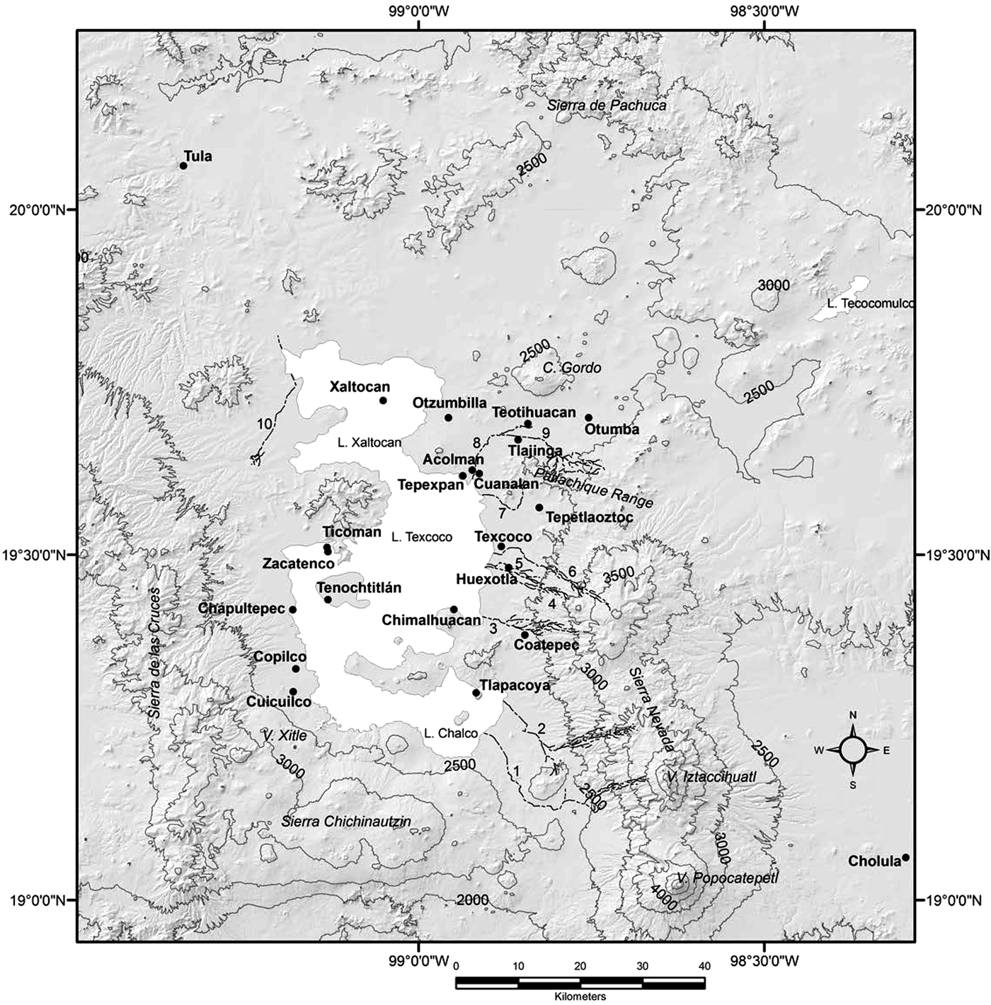
Current data reflect diverse environmental proxies, broadly distributed across the basin (Figure 1). Unfortunately, numerous gaps in the evidence at hand continue to hamper the development of a comprehensive vision of paleoenvironmental conditions and change through time in the region. The review that follows is organized geographically rather than chronologically because of the difficulty in reconciling diverse archives to produce an overall synthesis for the entire region, which in itself represents an important issue for future research.
The Basin of Mexico, indicating localities mentioned in the text. Rivers are numbered as follows: 1. Amecameca. 2. Tlalmanalco; 3. Coatepec; 4. San Bernardino; 5. Chapingo; 6. Texcoco; 7. Papalotla; 8. San Lorenzo; 9. San Juan; 10. Cuauhtitlan. Data proxies: Lake sediments (Lake Texcoco, Lake Tecocomulco, L. Chalco); Lakeshore sediments (Xaltocan, Cuanalan, Chimalhuacan, Tlapacoya); Alluvial sediments (Tepexpan, Texcoco, Ticoman, Zacatenco, Teotihuacan, Tlajinga, Otumba Tepetlaoztoc, Huexotla, Coatepec); Volcanic deposits (Cuicuilco, Copilco); Archaeological sediments (Teotihuacan, Tlajinga, Acolman, Cuanalan, Chapultepec, Tenochtitlan, Cuicuilco). (Map by Gerardo Jiménez Delgado).

AN OVERVIEW OF PALEOENVIRONMENTAL STUDIES IN THE BASIN OF MEXICO
Early Efforts to Establish a Role for Paleoenvironment in Basin of Mexico Archaeology
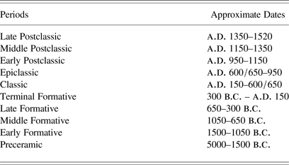
The earliest and most influential attempt to establish a relationship between climate, paleoenvironment and human activity in the Basin of Mexico was that proposed by Lorenzo (Reference Lorenzo, Mooser, White and Lorenzo1956), based on lacustrine records from Lake Texcoco (Deevey Reference Deevey1944; Foreman Reference Foreman1955; Mooser et al. Reference Mooser, White and Lorenzo1956; Sears Reference Sears1951, Reference Sears1952; Sears and Clisby Reference Clisby and Sears1955). In Lorenzo's scheme, dry periods were generally associated with higher temperatures. High lake levels and generally favorable conditions for extensive agriculture were postulated during the Early and Middle Formative periods, followed by progressive aridity and lower lake levels during the Late and Terminal Formative periods (Table 1); reductions in oak pollen were interpreted as evidence for decreasing precipitation. Although a slight improvement was suggested during the initial part of the Classic period, a trend towards unfavorable conditions manifest in low lake levels and reduced precipitation was associated with most of the remainder of the Classic period through the Middle Postclassic. Lake levels and precipitation were believed to have increased towards the end of the Late Postclassic, during the Aztec occupation of the region. Contrasting terms such as favorable and unfavorable, or references to improvement in past environmental conditions, although vague and confusing, generally referred to precipitation trends with less concern for temperature.
Chronology of the Basin of Mexico
In contrast to this view which prevailed throughout the 1960s, Sanders et al. (Reference Sanders, Parsons and Santley1979) hypothesized a close correspondence between the settlement history of the Basin of Mexico and what they termed “minor” climatic cycling in which dry years were assumed to be associated with low average temperatures. The Early Formative was thought to have been cooler and drier than at present, followed by an extended period of increased rainfall and warmer mean annual temperature, during which rapid population growth and spatial expansion took place in the basin. The latter half of the Terminal Formative was again cooler and drier, prompting the evolution of irrigation agriculture and the contraction of population in large parts of the region. Sanders and colleagues hypothesized that temperature and precipitation increased during the Classic period, coinciding with the expansion of population into drier portions of the region, followed once again by population reduction and contraction during the Epiclassic period. Warm-wet conditions were postulated for the Early and Late Postclassic periods, with an intervening episode of drier colder conditions (associated with population reduction and the fall of Tula) during the Middle Postclassic. Suitable data, however, necessary to test this framework for climate change and human impact on the environment were as yet unavailable, and later paleoenvironmental research based on lake sediments largely avoided the question because of their interest in earlier time periods as well as the difficulty with interpreting highly disturbed sediments, generally lumping any variation into a broad period of human disturbance marked by deforestation and both indirect and direct evidence for agricultural practices suggested by pollen spectra.
Modern Vegetation in the Basin of Mexico
Modern vegetation communities form the basis for an informal working hypothesis that essentially the same vegetation communities in the Basin of Mexico today were present throughout the Holocene, albeit with different distributions and proportional variability in secondary taxa. In general, indicators for changes in local flora and regional vegetation are among the most commonly used proxies in paleoenvironmental studies because plants respond directly to fluctuations in temperature and precipitation, as well as to climate change over time and catastrophic events. Although the response times for different plant species and, therefore, vegetation communities vary, it is possible to model these responses in relation to the biological requirements of the plants in question.
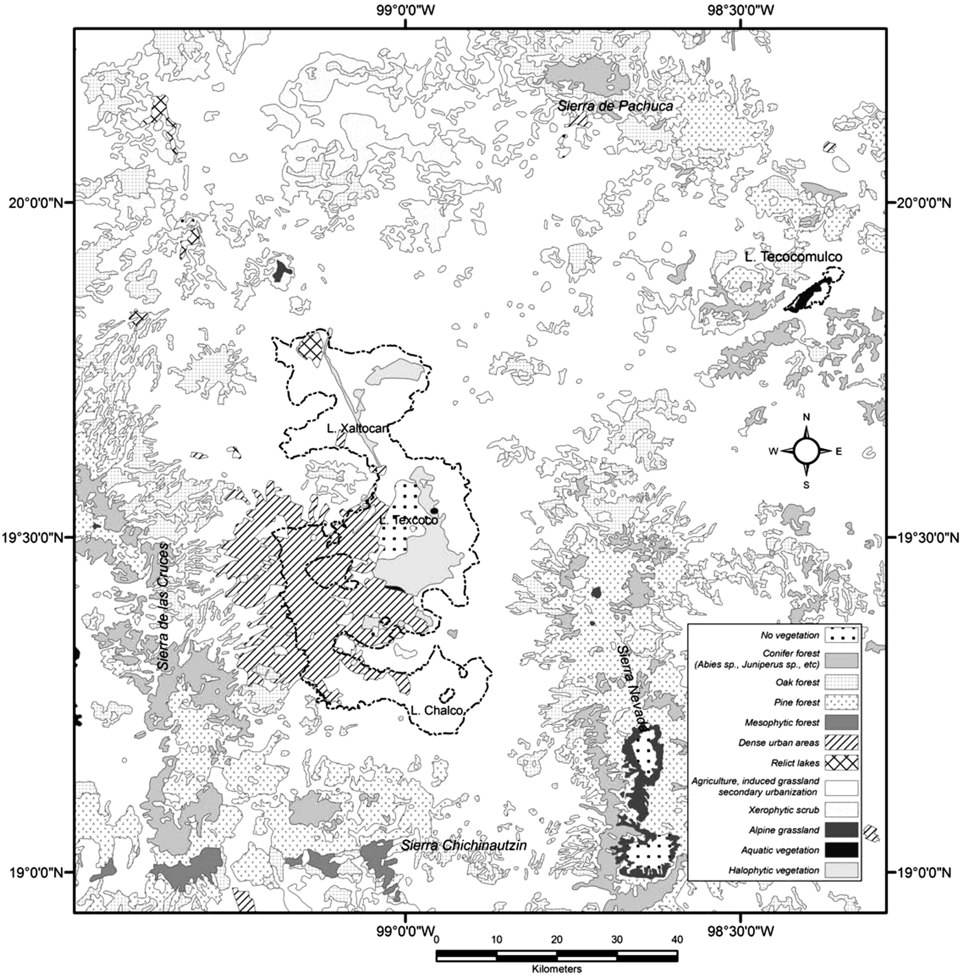
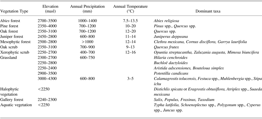
Table 2 summarizes major vegetation communities in the Basin of Mexico and their key components (Calderón de Rzedowski and Rzedowski Reference Calderón de Rzedowski and Rzedowski2001; Rzedowski Reference Rzedowski1954, Reference Rzedowski1957, Reference Rzedowski and Elizando1977, Reference Rzedowski1978; Rzedowski et al. Reference Rzedowski, Guzmán, Hernández and Muñiz1964); their basic geographic distributions are shown in Figure 2. In addition to palynological evidence for components of these vegetation communities in the paleoenvironmental record from the Basin of Mexico, many of these genera are also represented among the micro- and macro-botanical specimens recovered from archaeological excavations and soil profiles in the Basin of Mexico, further supporting the idea that the principal vegetative components have been present throughout the Holocene.
Modern vegetation communities in the Basin of Mexico. Modified from: Comisión Nacional para el Conocimiento y uso de la Biodiversidad, Mexico, Uso de suelo y vegetación de INEGI agrupado por CONABIO: http://www.conabio.gob.mx/informacion/gis/, accessed 12 January 2012. (Map by Gerardo Jiménez Delgado).
Principal Vegetation communities in the Basin of Mexico (Rzedowski Reference Rzedowski and Elizando1977, Reference Rzedowski1978, Reference Rzedowski, de Rzedowski and Rzedowski2001)
Key taxa in the paleoenvironmental record are interpreted as indicators for these vegetation communities, under the assumption that similar, although not necessarily identical, conditions existed in the past. This is not to say that no changes in vegetation communities have occurred through time. Instead, fluctuations in the spatial distribution of vegetation types, as indicated by key genera, as well as substitutions in the secondary floral components likely occurred in response to climate change, volcanic events and human activities. It should be noted that the absence of specific temperature and temperature ranges for some of the grass-dominated communities indicated in Table 2 reflect variability associated with the opportunistic nature of grassland taxa (rapid colonization of disturbed areas) in spite of elevation constraints. The range of temperature and precipitation ranges for vegetation at lower elevations varies with specific geographic location within the basin.
Studies of Basin of Mexico Paleoenvironment
Most paleoenvironmental studies dealing with conditions in the lake system of the Basin of Mexico (Chalco, Texcoco, and Tecocomulco) emphasize the Late Glacial Maximum and Late Pleistocene, with less concern for Holocene developments. This apparent research focus is partially a consequence of the generalized sense held for many decades that little in the way of significant change took place once global climate stabilized following the retreat of the North American ice sheets around 8000 BP (Anderson et al. Reference Anderson, Maasch, Sandweiss, Mayewski, Anderson, Maasch and Sandweiss2007; Wanner et al. Reference Wanner, Beer, Bütikofer, Crowley, Cubasch, Flückiger, Goosse, Grosjean, Joos, Kaplan, Küttel, Müller, Prentice, Solomina, Stocker, Tarasov, Wagner and Widmann2009). Human activity in the Basin of Mexico, however, became an important factor in ecosystem evolution during the Middle-Late Holocene. The temporal scale of most traditional paleoenvironmental studies based on lake sediments from this period tends to be coarse, the results taken to indicate some sort of human impact as previously mentioned. From an archaeological perspective, however, (and although there are many gaps in available data), the Holocene is the period when human activity can be documented and meaningfully evaluated with respect to natural phenomena and the interrelationship between climate and human cultural development.
Early investigations by Deevey (Reference Deevey1944) considered pollen recovered from archaeological sites such as Zacatenco, Copilco, Cuicuilco and Ticoman. Clisby and Sears (Reference Clisby and Sears1955), Foreman (Reference Foreman1955), and Sears (Reference Sears1951, Reference Sears1952) provided the first evidence for vegetation changes from the Pleistocene-Holocene periods, based largely on deep cores in Mexico City (Zeevaert Reference Zeevaert1953). Insufficient pollen counts as well as discontinuities in some of the cores limited their usefulness for correlations between lake sediments and established geological stratigraphy (Mooser et al. Reference Mooser, White and Lorenzo1956). Moreover, a major problem was the absence of radiocarbon dates for the sequence. Following Bradbury's (Reference Bradbury1971, Reference Bradbury, Lorenzo and Mirambell1986, Reference Bradbury1989) and Watts and Bradbury's (Reference Watts and Bradbury1982) diatom-based reconstructions of the histories of Lakes Chalco and Texcoco, a succession of paleoenvironmental studies of pollen, diatoms, and tephras recovered from these lakes began to appear in the literature, integrating a more consistent use of radiocarbon dating, tephrachronology, glacial records, and other tools such as pollen concentration and accumulation.
Niederberger (Reference Niederberger1987) expanded earlier research at Zohapilco, near Tlapacoya, to incorporate other sectors of the basin and a broader coverage of the entire pre-Columbian period of occupation, attempting a descriptive reconstruction of the landscapes of the region through time based on available archaeological, environmental, historical and ethnohistorical evidence. The publication of complementary environmental studies carried out at Tlapacoya (Lorenzo and Mirambell Reference Lorenzo and Mirambell1986) provided a diverse range of data derived from what was at the time one of the most multidisciplinary approaches to the study of human occupation in the southern basin.
Rigorous excavation and complementary geoarchaeological investigations in the alluvial plains and piedmont zones in the basin provide additional paleoenvironmental data for the Middle-Late Holocene. Research conducted by Cordova (Reference Cordova1997; Cordova and Parsons Reference Cordova and Parsons1997), and Frederick (Reference Frederick1997; Frederick et al. Reference Frederick, Winsborough, Popper and Brumfiel2005) are important contributions in this respect. Kovar (Reference Kovar, Sanders, Kovar, Charlton and Diehl1970) may have been the first to point out that increased sedimentation as a consequence of erosion would raise lake levels, underscoring the importance of examining geomorphological processes in the piedmont zones surrounding the Basin of Mexico to complement data from the lakes and adjacent shores.
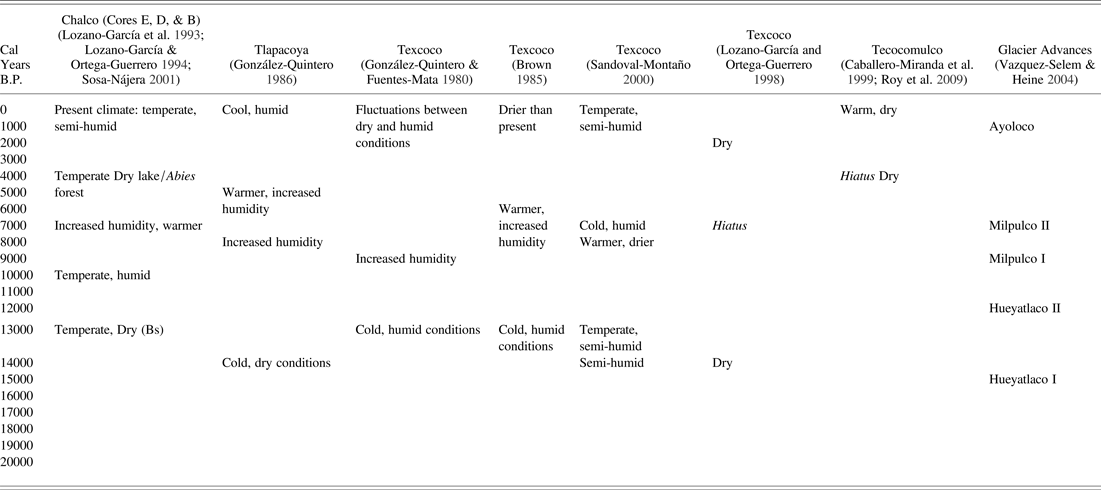
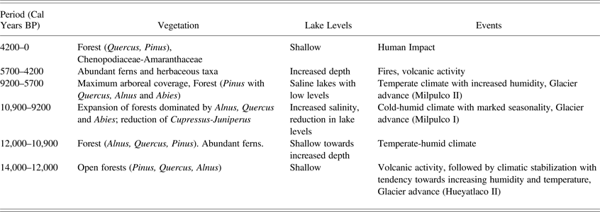
A schematic view of hypothesized climatic trends from several lake sediment cores in the region appears in Table 3. Supposed vegetation change and lake-level fluctuations based on pollen assemblages and diatoms are summarized in Table 4. Various authors report a significant change in pollen spectra evident in upper sections of cores, mainly represented by a decrease in Pinus (pine) together with increases in Chenopodiaceae-Amaranthaceae (cheno-ams; Amaranth family), Poaceae (grass family) and Asteraceae (sunflower family), together with the appearance of Zea (maize) (Lozano-García et al. Reference Lozano-García, Sosa-Nájera, Suguira and Caballero2005). The tendency to group the upper levels of the sequences is partially founded on Bradbury's (Reference Bradbury1989) argument that the last 2,000 years are absent from the record, based on extrapolation of the rate of sediment accumulation. For example, in the Tlapacoya sequence the Pómez Grano Fino (PGF) tephra at 150 cm is dated to 4880 ± 120 14C yrs BP (3952–3376 cal b.c.)Footnote 1 (Bradbury Reference Bradbury1989; García-Bárcena Reference García-Bárcena, Lorenzo and Mirambell1986). Diatoms were not preserved in the upper 50 cm as a result of plowing and consequent re-working of the desiccated lake plain. Extrapolation suggests that plowing has thus erased the last 2,000 years of the Chalco record. On the other hand, high concentrations of phytoliths relative to diatoms may indicate the predominance of grasses and other herbaceous plants in the basin, although the poor preservation of diatoms is likely the result of subaereal conditions and fluctuating water tables in the absence of perennial lacustrine conditions. A similar phenomenon is evident at Tepexpan (Sedov et al. Reference Sedov, Lozano-Garcia, Solleiro-Rebolledo, McClung de Tapia, Ortega-Guerrero and Sosa-Najera2010; Solleiro-Rebolledo et al. Reference Solleiro-Rebolledo, Sedov, McClung de Tapia, Cabadas, Gama-Castro and Vallejo-Gómez2006), although phytoliths were less abundant in the upper part of this sequence.
Variability in climatic trends based on pollen assemblages from lake sediment cores in the Basin of Mexico and glaciar advances on Iztaccíhuatl volcano
Vegetation change and lake level variability in the Basin of Mexico, between approximately 14000 Cal years BP and the present (modified from Sosa-Nájera Reference Sosa-Nájera2001)
A series of studies from various localities in the Basin of Mexico provide a broad sense of changing climate over time, however inadequate for an understanding of human adaptation through time. Table 4 summarizes the findings of this research. The Late Holocene sequences in Lakes Chalco, Texcoco, and Tecocomulco likely indicate human impact. The impact of volcanic activity is particularly significant in Lakes Chalco and Texcoco, and the presence of large charcoal concentrations in pollen samples are attributed to fires resulting from ash falls.
Pollen sequences from most of the lake basins in the Trans-Mexican Volcanic Belt (TMVB) indicate that significant climatic fluctuations occurred during the transition to the Holocene. The Early Holocene is thought to have been dry, based on paleolimnological data, but pollen records suggest an increase in mesic montane taxa indicating more humid conditions. Drier conditions during the Middle Holocene are more or less consistently upheld by the data, whereas the Late Holocene is confusing because the long history of human landscape alteration has disrupted the record. In general higher lake levels for the last 3,000 years in the Basin of Mexico (Caballero-Miranda and Ortega-Guerrero Reference Caballero-Miranda and Ortega-Guerrero1998; Caballero-Miranda et al. Reference Caballero-Miranda, Macías, Lozano-García, Urrutia-Fucugauchi and Castañeda-Bernal2001, Reference Caballero-Miranda, Ortega, Valadez, Metcalfe, Macías and Sugiura2002) suggest more humid climatic conditions than during the mid-Holocene, but again the evidence for human impact obscures the evidence. It should be emphasized that the subaereal exposure of the lakebeds at various times subjected them to deflation and eolian erosion which also contributed to the removal of sediments.
Geoarchaeological Studies
As mentioned previously, the earliest sedentary occupation in the Basin of Mexico is reported from Zohapilco, on the shore of Lake Chalco in the southern basin. Excavations by Niederberger (Reference Niederberger1976, Reference Niederberger1979) were complemented by systematic analyses of stratigraphy, soils and sediments, limnology, tephras, and faunal and botanical remains (including pollen). Along with the archaeological remains, these additional data provide important evidence for paleoenvironmental conditions in the southern sector of the basin up to the Late Formative period. Although these investigations were not conceived within the framework of a geoarcheological approach as currently understood, they certainly qualify as precursors to modern methods.
Based on pollen and macrobotanical remains recovered from excavation contexts, between approximately 5500–3500 b.c. Zohapilco was surrounded by dense mixed forest including evergreen and deciduous elements, grasslands on the alluvial surfaces, riparian vegetation at the lake margin, and abundant local and migratory waterfowl (Niederberger Reference Niederberger1976). A gradual increase in plant cultivation was suggested by an increase in the pollen record of Zea (maize) together with cheno-ams. A significant volcanic eruption interrupted settlement in the area (represented by the PGF tephra), after which the area was reoccupied around 2500 b.c. A rise in lake level indicated by a layer of redeposited sand is reported for 5500–3500 b.c., followed by a reduction in pine-oak forest and a regional increase in xerophytic genera (González-Quintero Reference González-Quintero, Lorenzo and Mirambell1986). At the same time, a local increase in aquatic, riparian and grassland vegetation was apparent. Although the inhabitants of the site depended largely on riparian resources, an increase in both the size and quantity of Zea pollen occurred as well. Gradual modification of the local landscape as a consequence of human resource utilization is evident during subsequent periods of occupation; deforestation is suggested by the increase in Zea and herbaceous pollen at the expense of arboreal taxa. A regression of the lake and other indicators for a slight decrease in precipitation as well as an increase in temperature occurred 1000–800 b.c. (Niederberger Reference Niederberger1976). The subsequent phase between 800 and 400 b.c. is associated with relative aridity based on the absence of forest elements and predominance of Ambrosia and Acacia, together with a reduction in the amount of Zea pollen. Evidence is negligible for occupation at the site during the Late Formative after 400 b.c.
There are limitations to stratigraphic evidence in the Basin of Mexico lake system, characterized by low sedimentation rates and an overall absence of laminated sediments (Lozano-García and Xelhuantzi-López Reference Lozano-García and Xelhuantzi-López1997; Metcalfe and Davies Reference Metcalfe and Davies2007), and the intensive exploitation of the lakebed following its drainage during the Colonial period. Confronted with these limitations, Frederick (Reference Frederick1997) undertook a regional analysis of the southeastern basin that focused on alluvial sequences, particularly stream beds entering the lake system with evidence for accumulation since at least ca. 1500 b.c. (Formative period). The important methodological advance of this research was the inclusion of settlement pattern data based on regional archaeological survey (Parsons et al. Reference Parsons, Brumfiel, Parsons and Wilson1982; Sanders et al. Reference Sanders, Parsons and Santley1979), which provided evidence for human activities directly related to landscape change over time.
Frederick documented evidence for radical changes in the course of the Amecameca River, including at least four channels, two of which are post-Conquest in age. Of the earlier channels, at least one was abandoned around 1500–1200 BP (Classic and Toltec periods). Radiocarbon dates on charcoal in channel deposits indicate that the most extensive sedimentation may have occurred as late as the eighteenth century. The Tlalmanalco River deposits indicate less re-routing than the Amecameca River. Evidence for tephra dated by radiocarbon to 5280 ± 130 14C yrs BP (4359–3797 cal b.c.) (Frederick Reference Frederick1997:20) probably represents the PGF event in this sequence, a significant marker evident in other areas of the basin.
Periods of landscape instability in the Chalco region were associated with population growth during the Formative period. An increase from fewer than 1,000 to approximately 30,000 inhabitants took place over a stretch of roughly 500 years, most occupying piedmont lands above 2,260 m above sea level. This coincides with a significant increase in cultivation causing widespread forest clearance, evident in the Tlapacoya IV (Zohapilco) pollen diagram between 1600/1530–790 b.c. (González- Quintero Reference González-Quintero, Lorenzo and Mirambell1986). Evidence for major landslides resulting from forest clearance was dated to 1918–1709 b.c. (without associated cultural materials) and 1367–1016 b.c. (with associated cultural materials). Rapid alluvial deposition resulting from erosion on the piedmont was widespread between 906–804 b.c. Low sedimentation, together with evidence for soil formation during the period between 400 b.c. and a.d. 400, bridges both the peak in Formative period population as well as significant demographic decline in the Chalco region during the Terminal Formative occupation. Floodplain deposition was reactivated during the Classic period, after about a.d. 400, and erosion may have persisted until the Toltec period (a.d. 1164–1207).
This increase in erosion-sedimentation apparently corresponds to the period in which a large proportion of the population seems to have already relocated to Teotihuacan in the northern basin (ca. a.d. 200; Plunket and Uruñela Reference Plunket and Uruñuela2006, Reference Plunket and Uruñuela2008), suggesting Terminal Formative period abandonment of piedmont agricultural systems. Although some resettlement is apparent in this area during the Classic period, small hamlets seem to predominate (Sanders Reference Sanders, Sabloff and Andrews1981:Figure 6.16). A new cycle of deforestation may have begun in association with gradual repopulation. Frederick (Reference Frederick1997) suggests that periods of sedimentation tend to correlate with periods of increased human population, whereas periods of population decline were marked by low rates of sedimentation and soil formation. Frederick also emphasizes a lack of apparent evidence for sedimentation between a.d. 1000 and recent times when the down-cutting of upland barrancas began, suggesting various scenarios as possible explanations: few new lands were brought into cultivation; piedmont lands were well-managed; or a large proportion of agricultural production focused on the lakeshore plain and chinampas on the lakebed at this time. Settlement pattern data (Sanders et al. Reference Sanders, Parsons and Santley1979; Sanders Reference Sanders, Sabloff and Andrews1981: Figure 6.21) indicate a dense distribution of predominantly small hamlets during the Early and Late Postclassic periods in the piedmont, and if Frederick's assessment is correct, suitable slope management was apparently an integral part of agricultural techniques during this period. The inherent low-resolution of erosion sequences and associated radiocarbon dating, however, preclude a definitive assessment at this time.
Cordova (Reference Cordova1997) applied a similar geoarchaeological approach in the Texcoco region of the eastern sector of the Basin of Mexico, combining settlement history, and evidence from historical archives for local land use with a study of geomorphological processes. Cordova (Reference Cordova1997) and Cordova and Parsons (Reference Cordova and Parsons1997) focused specifically on the issue of landscape transformation, particularly during the Late Postclassic and Early Colonial periods. Both alluvial and piedmont sequences in the northern sector of the Texcoco region were studied, including part of the southern Teotihuacan Valley. The alluvial sequence of the lower valleys of the San Juan, Papalotla and Coatepec rivers revealed evidence for floods associated with the Classic and Early Postclassic periods, while pedestals in the piedmont revealed considerable evidence for Late Aztec slope management. At the site of TX-AZ-86, a barranca between the Texcoco and Chapingo rivers showed evidence for incision (downcutting) prior to about 5000 BP and subsequent filling by a mudflow containing ash particles. The timeframe suggests that this may be related to the eruption of Popocatepetl, also responsible for the PGF tephra. Additional mudflows were followed by incision, probably corresponding to the Classic-Epiclassic period, before Aztec occupation when slopes were managed by metepantli (alternating rows of maguey and cultivated strips) terracing to control erosion. No historical record for site abandonment was located, but Cordova argues that severe erosion in the area probably began around the early sixteenth century; an early seventeenth century document describes the area as pedregal (unworkable stone) rather than tierra (cultivable land). Additional evidence for Colonial period barranca incision is also provided by the history of collapse and reconstruction of a bridge originally built during Late Aztec times between the Chapingo and San Bernardino rivers, at Huexotla (TX-AZ-87). The Texcoco River appears to have changed course at least twice, and Cordova cites both alluvial and topographic evidence to suggest that it was diverted to channel floodwaters and alluvial materials away from the imperial capital at the time of Nezahualcoyotl (ca. a.d. 1400–1470). The city of Texcoco and surrounding plains were prone to flooding during the early colonial period, as indicted by the deposition of silt covering Aztec structures. In the alluvial plains of the Texcoco region, it is evident that areas where no surface remains were detected during surveys coincide with recent flood-overbank deposition. Brickyard exposures and the walls of incised streams revealed evidence for pre-Columbian occupation below several meters of alluvium. The Late Holocene time frame for these processes precluded the formation of well-developed soils.
Cordova and Parsons (Reference Cordova and Parsons1997) also examined in detail the sequence of erosion at the site designated as TX-AZ-78 in the area of Huexotla, one of the few remaining vestiges of a Late Aztec (a.d. 1350–1520) dispersed village, a common settlement type in the piedmont at that time. Expansion of settlement in the area, from the Middle Formative (ca. 850 b.c.) through the Terminal Formative took the form of a gradual increase in the number of sites occupying different ecological zones. Maximum population was not attained, however, until the Late Aztec occupation. During the Classic period (a.d. 150–600/650), a reduction in the number of sites occurred, with a few hamlets situated in the lower piedmont and no evidence of occupation in the volcanic hills or upper piedmont. Population reached its lowest point during the Epiclassic and Early Postclassic periods, a.d. 600/650–950, although sizeable settlements persisted in the volcanic hills and piedmont to the north in Tepetlaoztoc and to the south near Coatepec, possibly related to a territorial division between Tula and Cholula (Cordova Reference Cordova1997). After a.d. 950, population began to recover and a few hamlets appeared in the volcanic hills and lower piedmont, adjacent to the alluvial plain. Population increase continued during the subsequent Early Aztec phase (a.d. 1150–1350) and by the Late Aztec phase a large number of dispersed villages were situated throughout the upper and lower piedmont. After less than the first century of the early colonial period, notable changes in size, number and patterning of settlements resulted from drastic reduction in the indigenous population as a consequence of disease together with the depopulation of rural zones produced by congregación, forced resettlement by the Spanish of remaining indigenous inhabitants of many rural areas into towns.
In the area of Tepetlaoztoc, in the upper piedmont, erosion is strongly correlated with settlement history, particularly abandonment. The alternation of tepetate (indurated pyroclastic deposits) with unconsolidated ash deposits and paleosols (indicating generalized instability and severe erosion) is apparent during Early to Middle Holocene times in this area. A subsequent period of landscape stability, however, is suggested by the development of two soil horizons on colluvium overlying a white tepetate, the most recent of the series, dated at Barranca Honda, to 5313 ± 51 14C yrs BP (4320–3995 cal b.c., likely corresponding to the PGF tephra; cf. Cordova and Parsons Reference Cordova and Parsons1997:192), only to be interrupted by Late Holocene erosion associated with Late Aztec-Colonial ceramics. Techniques for improvement as well as reclamation of land, mainly Late Aztec, are evident in the remains of metepantli terraces and check dams which permit soil buildup in barranca courses. Early Classic to Early Postclassic ceramics associated with one of the pedestals in the region suggests the existence of a Classic-period settlement destroyed by erosion, prior to resettlement during the Early Aztec phase. Remains of Late Aztec sites are spatially associated with headwater rills and badland areas, indicating a relationship with settlement abandonment following the epidemics of the 1540s and the congregación policy undertaken throughout the sixteenth century (Cordova Reference Cordova1997). Although settlement nucleation took place on the alluvial plain and lower piedmont, terraces and check dams in the upper piedmont were abandoned and gradually destroyed as a result of intense precipitation events.
Historical documents refer to numerous episodes of intense precipitation and consequent floods, particularly during the early seventeenth century, which also provoked the destruction of piedmont lands and check dams. The most important factor in the sequence of erosive processes in the area is abandonment—the decline of populations during the Classic period and during the early years of the colonial occupation. Piedmont soils, particularly those developing on tepetate substrates, required constant management both to maintain suitable depth and fertility as well as to control erosion.
Cordova (Reference Cordova1997) also employed pollen analysis from the alluvial sequence of Barranca Honda to understand vegetation disturbance through time in the uplands as a result of agriculture and erosion. Selected taxa excluded floodplain elements such as Taxodium (cypress), Fraxinus (ash) and Salix (willow), focusing instead on Pinus (pine), Quercus (oak), Juniperus (juniper), Alnus (alder), Mimosa (cat claw), Acacia, Zea (maize), Poaceae (grasses), Asteraceae (sunflower family) and Chenopodium-Amaranthaceae (goosefoot-amaranth). Based on the hypothesis that the modern plant communities in the piedmont are secondary and successional (Rzedowski Reference Rzedowski and Elizando1977), it was assumed that the pollen spectra from more recent deposits should indicate an increase in frequencies of juniper and oak together with cultivated plants, associated weeds, scrub and grasses. Although the pollen spectra indicate a transition from predominantly arboreal genera such as oak and juniper to herbaceous genera in the piedmont, however, juniper itself appears to be relatively stable throughout the sequence, indicating that it was not responding to human impact but rather that it was well-adapted to changing conditions in the piedmont through time. Pine appears only to have been a major component of regional vegetation around the Terminal Formative, registering a significant decline during the Classic-Early Postclassic periods as well as a further decline during the Early Colonial period (Cordova Reference Cordova1997).
From the standpoint of vegetation change, Cordova's pollen analysis points to the predominance of mixed pine-oak forest during the Early-Middle Holocene, severely damaged by the PGF ashfall at the end of the Middle Holocene, and replaced by predominantly pine forest by the end of the Formative period. The reduction of pine as well as juniper associated with the Classic–Early Postclassic period is undoubtedly related to more intensive exploitation of pine and juniper for construction and fuel as well as the expansion of agricultural areas.
Cordova also considered the Terminal Formative site of El Tepalcate, located north of the modern community of Chimalhuacan, on the former bed of Lake Texcoco. This was possibly a salt-producing community, and a layer of vegetation used to build up a stable surface for construction was radiocarbon dated to 2090 ± 35 14C yrs BP (202–2 cal b.c.) (Cordova Reference Cordova1997:428). The site was abandoned around the first century a.d. and the occupation was covered by a significant transgression of the lake, lasting through the Classic and Early Postclassic periods, and exposed again as the lake receded at the end of the Late Toltec through the Late Aztec phases. Eolian deposits and beach formations indicate that the area remained dry from Late Aztec times through the Colonial period.
Late Holocene horizons in the Tepexpan sequence at the edge of Lake Texcoco (Sedov et al. Reference Sedov, Lozano-Garcia, Solleiro-Rebolledo, McClung de Tapia, Ortega-Guerrero and Sosa-Najera2010; Solleiro-Rebolledo et al. Reference Solleiro-Rebolledo, Sedov, McClung de Tapia, Cabadas, Gama-Castro and Vallejo-Gómez2006) have recently permitted a clearer understanding of the natural trend towards desiccation, as well as landscape development prior to settlement of the region by permanent agriculturalists. Excavation at Cuanalan, in the southern Teotihuacan Valley, provided substantial information with respect to environmental conditions during the Early-Middle Formative period in that portion of the Basin of Mexico (Manzanilla Reference Manzanilla, Monjarrás-Ruíz, Brambila and Rocha1985), in addition to paleoethnobotanical (Álvarez del Castillo Reference Álvarez del Castillo1984; Vélez Saldaña Reference Vélez-Saldaña2001) and faunal remains, indicators of adaptation to the lakeshore as well as agricultural resources.
Lake levels began to drop following the conquest, as described in historical documents (Torquemada Reference Torquemada1975 [1615]), although occasional episodes of increased precipitation accounted for considerable rises (and consequent flooding, for example 1555, 1604–1629). Berres's (Reference Berres2000) analysis of fish species and waterfowl remains also support lower water levels in basin lakes at this time.
Reconstruction of the history of Late Postclassic and Early Colonial period lake levels is further hindered by alterations resulting from the system of dikes and causeways initiated during the Late Aztec period and the intentional drainage undertaken during the colonial period. Furthermore, Cordova's research at El Tepalcate confirmed the difficulty experienced by other paleoenvironmental investigations carried out in the lakes of the Basin of Mexico as a result of the slow rate of sedimentation and the rapid loss of sediment by deflation during periods of exposure. These processes explain the significant hiatuses present in the lacustrine record and the absence of a suitable paleoenvironmental record for the Late Holocene mentioned in the syntheses of lake sediment studies. They argue for the importance of developing appropriate techniques for the recovery of data from the interface between lake and alluvial environments.
Preliminary geoarchaeological research at Xaltocan, in the northern basin, provides some paleoenvironmental information relevant for the Late Holocene as well (Frederick et al. Reference Frederick, Winsborough, Popper and Brumfiel2005). A number of beach formations were described and tentatively placed in a chronological sequence based on geological and archaeological stratigraphy, although the independent dating of deposits necessary to construct a meaningful sequence has not yet been undertaken. Extensive beaches suggest that the lakes of the northern basin were both persistent and stable.
Frederick et al. (Reference Frederick, Winsborough, Popper and Brumfiel2005) also partially studied a zone of chinampas fed by a freshwater spring at Otzumbilla on the eastern shore of Lake Xaltocan at the base of Cerro Chiconauhtla. Diatoms recovered from lacustrine strata situated below a chinampa surface indicated a shallow saline lake. The analysis of macro and microbotanical remains from earlier stages of the research at Xaltocan also contributes to the understanding of local vegetation and available resources from the Epiclassic period through the Late Postclassic. Maize was the predominant component of the plant assemblage, although remains of many wild taxa associated with saline conditions as well as cultivated plots were also recovered (McClung de Tapia and Martínez-Yrizar Reference McClung de Tapia, Martínez Yrizar and Brumfiel2005). Evidence for intensive maize production in chinampas (Morehart and Eisenberg Reference Morehart and Eisenberg2009), irrigated with freshwater transported from springs at some distance from the plots is an important indicator of the scale of human modification of the natural environment during the Middle Postclassic period in the region.
Recent Directions in the Teotihuacan Valley
The Teotihuacan Valley area in the northeastern sector of the basin is important because it was the location of Teotihuacan, one of the earliest pre-Columbian cities in the New World and the center of a state that dominated Mesoamerica over at least 500 years (a.d. 100–600). Archaeological research has been conducted in the Teotihuacan Valley for over a century, including a detailed survey of the history of settlement in the region (Sanders Reference Sanders1965, Reference Sanders, Sabloff and Andrews1981; Sanders et al. Reference Sanders, Parsons and Santley1979) and the development of the map of the Classic-period city (Millon Reference Millon1970, Reference Millon1973; Millon et al. Reference Millon, Drewitt and Cowgill1973). Paleoenvironmental research to establish a topographic sequence of soils and sediments and to study macro- and micro-botanical remains recovered from soils and archaeological contexts began approximately twenty years ago, although paleoethnobotanical studies have been a fundamental part of archaeological research in the region for more than three decades (McClung de Tapia Reference McClung de Tapia1977, Reference McClung de Tapia1978, Reference McClung de Tapia1980, Reference McClung de Tapia, de Tapia and Rattray1987; McClung de Tapia and Tapia-Recillas Reference McClung de Tapia, Tapia-Recillas and Manzanilla1993; McClung de Tapia and Aguilar-Hernández Reference McClung de Tapia and Hernández2001). Investigation into the development of agricultural systems in the region has a long history as well (Charlton Reference Charlton, Charlton and Nichols1990; Lorenzo Reference Lorenzo and Lorenzo1968; McClung de Tapia Reference McClung de Tapia and Lentz2000; Nichols Reference Nichols, de Tapia and Rattray1987; Nichols and Frederick Reference Nichols and Frederick1993; Nichols et al. Reference Nichols, Spence and Borland1991; Sanders Reference Sanders1965).
The recovery and identification of paleoethnobotanical remains (macrobotanical specimens, including wood charcoal) from excavations at the urban center of Teotihuacan, as well as some of the sites elsewhere in the valley, is carried out routinely. The analysis of wood charcoal recovered from archaeological contexts reveals the presence of pine-oak forest throughout the regional sequence, although some fluctuations in the relative proportions of taxa are evident as well (Adriano-Morán Reference Adriano-Morán2000; Adriano-Morán and McClung de Tapia Reference Adriano-Morán and McClung de Tapia2008). The continual presence of secondary taxa indicates management practices related to wood exploitation. Both in archaeological contexts as well as in most of the soils and sediments studied from the Teotihuacan region, however, pollen is poorly preserved. Phytoliths, on the other hand are relatively well represented and permit development of a general picture of changes through time in the distributions of grasses associated with cool-humid conditions (Pooideae, C3 cool season grasses) and those adapted to semi-arid conditions (grass sub-families Panicoideae and Cloridoideae—C4 warm season grasses). Because of the importance of soils to prehistoric agricultural economies as well as a source of climatic information, field research during the past fifteen years has been directed towards a detailed study of soil formation and geomorphological processes in the region (Cabadas-Baéz Reference Cabadas-Báez2004; McClung de Tapia et al. Reference McClung de Tapia, Solleiro-Rebolledo, Gama-Castro, Villalpando and Sedov2003, Reference McClung de Tapia, Villalpando, Solleiro, Gama, Benavides, Manzanilla and Mirambell2004, Reference McClung de Tapia, Martínez Yrizar and Brumfiel2005; Rivera-Úria et al. Reference Rivera-Úria, Sedov, Solleiro-Rebolledo, Pérez-Pérez, McClung de Tapia, González and Gama-Castro2007; Sedov et al. Reference Sedov, Lozano-Garcia, Solleiro-Rebolledo, McClung de Tapia, Ortega-Guerrero and Sosa-Najera2010; Solleiro-Rebolledo et al. Reference Solleiro-Rebolledo, Sedov, McClung de Tapia, Cabadas, Gama-Castro and Vallejo-Gómez2006, Reference Solleiro-Rebolledo, Sycheva, Sedov, McClung de Tapia, Rivera and Salcido-Berkovich2011). The recovery and analysis of phytoliths were included in order to detect the presence of paleosols, on the one hand, and the spatial variability of soils and regional vegetation trends on the other.
Early sedentary communities in the Teotihuacan region mainly occupied the piedmont rather than the deep soil alluvium in the central part of the valley where the risk of frosts was an important limiting factor. The use of techniques for the conservation of soil and humidity, such as channeling of runoff, was probably carried out from an early period on slopes to enhance humidity concentrations for rainfall dependent cultivars and to afford some kind of protection against soil gravity transport and gully and sheet erosion during torrential seasonal showers as well as wind erosion in the dry season. Evidence for such techniques is difficult to date, mainly, however, because of the mixture of cultural and sedimentary materials contained in channels. The earliest indications of such techniques are dated to the Terminal Formative period (Tzacualli-Miccaotli phases, approximately a.d. 100–250; Charlton Reference Charlton, Charlton and Nichols1990; Nichols and Frederick Reference Nichols and Frederick1993), associated with the development of the urban center of Teotihuacan. The construction of terraces may be as late as a.d. 1300–1500, corresponding to the Aztec occupation of the region, although remains from this period would mask earlier deposits.
The topographic sequence of soils in the Teotihuacan Valley (Cabadas-Baéz Reference Cabadas-Báez2004; Solleiro-Rebolledo et al. Reference Solleiro-Rebolledo, Sedov, Sycheva, Sánchez-Pérez, Pustovoitov and Sauer2015) indicates Pleistocene paleosols with ages of 22000 yrs BP and 18000 yrs BP at high elevations (Cerro Gordo). In the piedmont of the Patlachique Range, a paleosol with an age of approximately 11000 yrs BP was observed. Soils in the alluvial plain (Otumba and Tepexpan) are more recent and are generally poorly developed. On the edge of the former Lake Texcoco at Tepexpan, the sequence includes a pedosediment developed in a swamp environment overlain by three paleosols (Sedov et al. Reference Sedov, Lozano-Garcia, Solleiro-Rebolledo, McClung de Tapia, Ortega-Guerrero and Sosa-Najera2010; Solleiro-Rebolledo et al. Reference Solleiro-Rebolledo, Sedov, McClung de Tapia, Cabadas, Gama-Castro and Vallejo-Gómez2006). The sequence from approximately 5000 BP to the present is the most complete as well as being the most relevant from the perspective of human occupation in the Teotihuacan region. Evidence for soil formation varies depending upon location (McClung de Tapia et al. Reference McClung de Tapia, Solleiro-Rebolledo, Gama-Castro, Villalpando and Sedov2003, Reference McClung de Tapia, Martínez Yrizar and Brumfiel2005), but recent research in the region has detected a productive buried soil with vertic properties (originally mentioned by Charlton [Reference Charlton1972] and recognized as well by Nichols [1987]), broadly distributed and frequently overlain by several meters of redeposited sediments, radiocarbon dated to between and 2980 ± 40 14C yrs BP (1375–1055 cal b.c.) and 2060 ± 40 (187–25 cal a.d.) Rivera-Úria et al. Reference Rivera-Úria, Sedov, Solleiro-Rebolledo, Pérez-Pérez, McClung de Tapia, González and Gama-Castro2007; Solleiro-Rebolledo et al. Reference Solleiro-Rebolledo, Sycheva, Sedov, McClung de Tapia, Rivera and Salcido-Berkovich2011, Sánchez-Pérez et al. Reference Sánchez-Pérez, Solleiro-Rebolledo, Sedov, McClung de Tapia, Golyeva, Prado and Ibarra-Morales2013). Sánchez-Pérez et al. (Reference Sánchez-Pérez, Solleiro-Rebolledo, Sedov, McClung de Tapia, Golyeva, Prado and Ibarra-Morales2013) studied the regional distribution of this soil as well as its agricultural potential, while González-Árqueros et al. (Reference González-Arqueros, Selem, Gama-Castro and McClung de Tapia2013) examined evidence for erosive processes and subsequent burial of the soil. Pollen and phytoliths recovered from soil profiles in both investigations indicate pre-Columbian maize cultivation in addition to other components of the local and regional flora (Sánchez-Pérez et al. Reference Sánchez-Pérez, Solleiro-Rebolledo, Sedov, McClung de Tapia, Golyeva, Prado and Ibarra-Morales2013; Martínez-Ríos Reference Martínez-Ríos2014). Stable carbon isotope signatures (δ13C) provide additional support for maize cultivation (McClung de Tapia and Adriano-Morán Reference McClung de Tapia and Adriano-Morán2012).
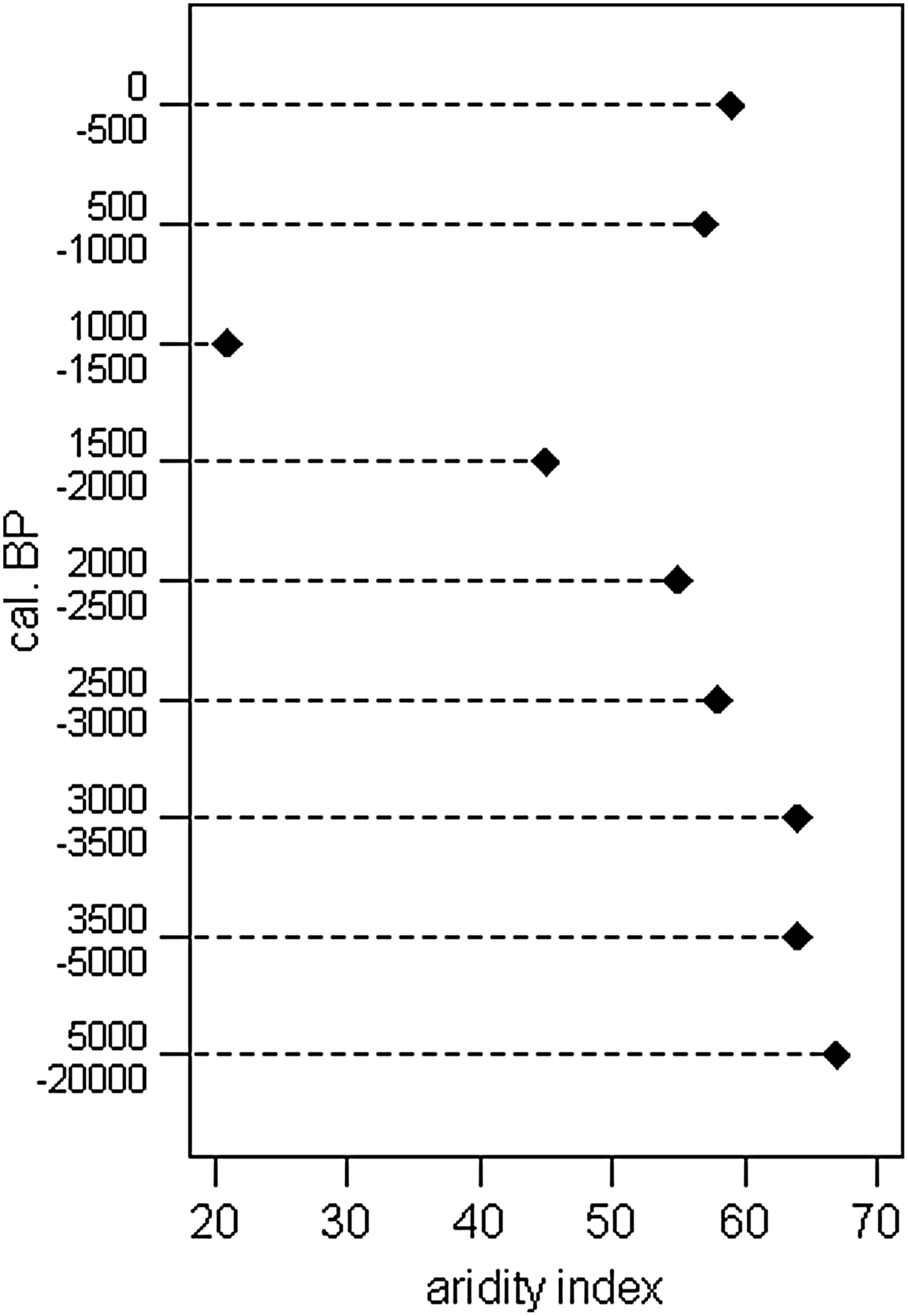
The ratios of grass phytoliths from the radiocarbon-dated horizons of soil profiles in the Teotihuacan region indicate notable changes over time in the predominance of grasses pertaining to the subfamilies Pooideae (C3), Panicoideae and Chloridoideae (C4) (McClung de Tapia et al. Reference McClung de Tapia, Baez, Solleiro, Castro, Vallejo, Korstanje and del Pilar Babot2008), and these trends are reaffirmed by an aridity index (Figure 3).
Aridity index based on the proportion of phytoliths corresponding to grasses of the Chloridoideae subfamily with respect to the sum of Panicoideae and Chloridoideae, indicating overall trends in the Teotihuacan Valley from 20,000 14C yrs BP to the present (McClung de Tapia et al. Reference McClung de Tapia, Baez, Solleiro, Castro, Vallejo, Korstanje and del Pilar Babot2008).
Phytolith evidence from horizons corresponding to 1500–1000 BP indicates relatively high humidity throughout the study region during this interval. Some researchers have argued, however, for notably drier conditions between ca. 1500 and 900 BP in the lake basins of the Transvolcanic Belt that stretches across central Mexico (Arnauld et al. Reference Arnauld, Carot, Fauvet-Berthelot and Pétrequin1994; Caballero-Miranda et al. Reference Caballero-Miranda, Macías, Lozano-García, Urrutia-Fucugauchi and Castañeda-Bernal2001; García Reference García1974; Heine Reference Heine2003; Metcalfe Reference Metcalfe1994; Metcalfe and O'Hara Reference Metcalfe and O'Hara1992; Metcalfe et al. Reference Metcalfe, Street-Perrott, Brown, Hales, Perrott and Steininger1989; Metclafe et al. Reference Metcalfe, O'Hara, Caballero and Davies2000; O'Hara et al. Reference O'Hara, Street-Perrott and Burt1993), while others suggest that conditions may have been more humid in some parts of central Mexico during at least part of the same period (Cordova Reference Cordova1997; Frederick Reference Frederick1997; Heine Reference Heine1987). These apparent discrepancies are likely due to the highly localized responses of different landscape components to the complex interrelationships among elevation and topographic characteristics, local soil conditions, land-use histories and other factors that affect the preservation of organic materials.
Much of the extensive erosion evident in the Teotihuacan Valley took place during the Colonial period (McClung de Tapia Reference McClung de Tapia, Cooper and Sheets2012; González Arquero Reference González-Arqueros, Selem, Gama-Castro and McClung de Tapia2013). Earlier erosive events, however, appear to be associated with the abandonment of Teotihuacan and surrounding population decline (McClung de Tapia Reference McClung de Tapia, Martínez Yrizar and Brumfiel2005). While sediments of approximately the same age were redeposited from higher slopes onto the alluvial plain in both Otumba and Tlajinga, this may represent separate events. In the absence of evidence for Late Holocene volcanic activity directly affecting this region, it is possible that deforested slopes were subject to the effects of torrential rainfall events that mobilized large masses of sediment and soil from upper slopes (see Cordova Reference Cordova1997). The fact that Aztec-period potsherds are present in the re-deposited sediments overlying Middle-Late Postclassic agricultural surfaces in the Otumba area suggests that most of the mass movement took place following the Late Postclassic, during the Colonial period (McClung de Tapia Reference McClung de Tapia, Cooper and Sheets2012; McClung de Tapia and Adriano-Morán Reference McClung de Tapia and Adriano-Morán2012). Additional evidence for incision in barrancas supports this hypothesis (Pérez-Pérez Reference Pérez- Pérez2003).
Chronological control is insufficient at present to permit a conclusive evaluation of specific changes in vegetation through time. Further soil analyses and radiocarbon assays on more reliable samples are necessary to provide a better understanding of geomorphic processes and human impact in the region (McClung de Tapia et al. Reference McClung de Tapia, Solleiro-Rebolledo, Gama-Castro, Villalpando and Sedov2003), and to situate this information within a chronological framework that is meaningful from an archaeological perspective. Finally, future analyses of phytoliths in securely dated cultural contexts will be fundamental in order to test the hypotheses presented here.
Cordova's (Reference Cordova and Parsons1997) study of the alluvial sequence of the lower Teotihuacan Valley, including in the areas of Acolman and Cuanalan, provide additional information with respect to the erosion processes and, particularly, the history of floods in the region. The hydrology of the Teotihuacan Valley was important for the development of the margins of Lake Texcoco because it provided the main source of fresh water to the saline lake, and contributed to the maintenance of swampy conditions at the lake margin. Episodic surficial flow caused by torrential summer rains could be highly destructive but a considerable part of the water permeated the lava substrate at higher elevations, emerging as springs at lower elevations (Bradbury Reference Bradbury1989). The construction of a dam close to the convent at Acolman around 1604, ostensibly to control the entry of floodwaters into Mexico City, resulted in the formation of a shallow lake in the southern valley alluvial plain (Cordova Reference Cordova1997; Gamio Reference Gamio1922; Skopyk and Martínez-Yrizar Reference Skopyk and Martínez-Yrizar2015). Intense precipitation during the eighteenth century led to overflowing of the canals that directed runoff from the San Juan and San Lorenzo rivers in the central Teotihuacan Valley and the rivers of the Texcoco plain, breaching the dam and inundating the entire alluvial plain. Buried Aztec and colonial structures have been located at depth of 3.5–4 m (Cabrera Castro Reference Cabrera Castro, Ruiz-Gallut and Torres-Peralta2005) in the southern part of the town of San Juan Teotihuacán, suggesting the intensity of floods and associated deposition of sediment.
CLIMATE CHANGE AND HUMAN IMPACT IN THE BASIN OF MEXICO
Research on paleoenvironmental change in the Basin of Mexico due to climate change and human impact reveals a series of broad environmental shifts during the Holocene. These changes often take the form of erosion and sedimentation, re-sculpting the prehistoric landscape and providing different challenges to human residents of the region.
The apparent discrepancy between Frederick's (Reference Frederick1997) interpretation of the timing of sedimentation and human population trends during the pre-Columbian period and that which is postulated by Cordova (Reference Cordova1997) and McClung de Tapia et al. (Reference McClung de Tapia, Domínguez-Rubio, Solleiro-Rebolledo, Gama-Castro and Sedov2005) requires additional investigation, although this is likely related to issues of temporal and spatial scale which arise as one attempts to correlate evidence from the regions discussed. For example, some cores or profiles have higher temporal resolution, whereas others have a longer sequence but offer less detail. In some cases this may be due to sampling strategies designed in response to specific research questions or techniques appropriate to a particular discipline. Or it may be the product of poor preservation or disturbance that has altered the sedimentary record.
Over time, between the Terminal Pleistocene-Holocene and the beginning of the Colonial period in the sixteenth century, the Basin of Mexico bore witness to the presence of hunter-gatherer bands, the disappearance of Pleistocene fauna, the transition to permanent human settlements and, ultimately, the rise and fall of regional centers of varying degrees of political and economic strength. Although in different ways, the lakeshore, adjacent alluvial plains and surrounding forests have always constituted important areas for resource exploitation and settlement.
Throughout the pre-Columbian settlement of the Basin of Mexico, communities undertook massive hydraulic works that significantly impacted the landscape as well as the natural hydrology: channeling of the San Juan River and, possibly, the San Lorenzo River during the Classic period (Cowgill Reference Cowgill2015), and re-routing the Cuauhtitlan, Texcoco, and Amecameca rivers during the Late Postclassic (Cordova Reference Cordova1997; Frederick Reference Frederick1997; Sanders et al. Reference Sanders, Parsons and Santley1979). In addition, the construction of dikes and causeways to control water levels of Lake Texcoco, the aqueduct at Chapultepec, and the Colonial dam at Acolman are only a few of the numerous historical examples of infrastructure designed to tame the natural environment for the benefit of human communities. Complex agroecological systems, including permanent and seasonal irrigation systems, terraces, and chinampas as well as rain-fed cultivation, contributed as well to the creation of the man-made landscape.
Recent geoarchaeological research has broadened our understanding of how human communities modified the landscape and altered biological communities through habitat alteration. Paleoenvironmental studies, although providing a baseline for the recognition of the relative importance of particular vegetation types and their responses to climate change as well as human impact, have not been particularly useful for the time period during which human exploitation and modification of the environment has been most significant. Hopefully, future paleoenvironmental studies will consider more recent periods in greater detail, thereby contributing to an understanding of how the landscape responds to human impact. Insofar as climate change is concerned, the scale of investigation undertaken in the region so far is inadequate to differentiate between local climatic fluctuations and human impact on the one hand, and broader global trends on the other. For example, recent publications by Acuña-Soto et al. (Reference Acuña-Soto, Stahle, Therrell, Gómez-Chavez and Cleaveland2005) and Lachniet et al. (Reference Lachniet, Bernal, Asmerom, Polyak and Piperno2012) are instructive. The former points to severe drought during the late seventh century a.d. extending from the North American Great Plains through Central America, which in conjunction with an epidemic was believed to have contributed to the downfall of Teotihuacan. The latter indicates significantly decreased humidity in Juxtlahuaca Cave in Guerrero during the seventh and eighth centuries a.d., arguing that such changes may have caused culture change in Mexico including Teotihuacan's demise. Without entering into a detailed discussion, both hypotheses ignore recent archaeological evidence, particularly indications that Teotihuacan was well on its way to decline by a.d. 600 (Beramendi-Orosco et al. Reference Beramendi-Orosco, González-Hernández, Urrutia-Fucugauchi, Manzanilla, Soler-Arechalde, Goguitchaishvili and Jarboe2009, Cowgill Reference Cowgill2015). Furthermore, the lower limit of precipitation during the drought period proposed by Lachniet et al. (Reference Lachniet, Bernal, Asmerom, Polyak and Piperno2012), 500 mm, is the average annual precipitation for most of the Teotihuacan Valley today, so it is not unusual. Caballero et al. (Reference Caballero-Miranda, Ortega, Valadez, Metcalfe, Macías and Sugiura2002) found evidence for similar changes in the upper Lerma Basin, outside of the basin itself. Evidence for drought during these centuries, and their impacts in the Basin of Mexico requires continued research, therefore exploring the potential role of drought, possibly linked to climate change, on pre-Columbian cultures in the Basin of Mexico—including the collapse of Teotihuacan—remains a priority.
Perhaps the most significant factor that should stimulate future research is the potential contribution of archaeology to understanding long-term human adaptation to the dynamic forces of climatic and ecosystemic change —the longue duree — and the possibility of learning from the past that such an approach entails. In addition to expanding the coverage of paleoenvironmental and geoarchaeological studies significantly, future examinations of the prehistoric Basin of Mexico environment would greatly benefit from the establishment of a radiocarbon database including dates from tephras and soils, along the lines of that developed by Siebe (Reference Siebe2000) for research on the eruptive sequence of Xitle, and that developed by McClung de Tapia et al. (Reference McClung de Tapia, Domínguez-Rubio, Solleiro-Rebolledo, Gama-Castro and Sedov2005) for the sequences of buried soils and geomorphological processes in the Teotihuacan Valley. It would be useful to include profile descriptions and, in the case of tephras, geochemical characterizations (cf. Ortega-Guerrero and Newton Reference Ortega-Guerrero and Newton1998) that would permit periodic updating based on new developments in the calibration curve, thus allowing archaeologists to recognize significant tephras and, in the case of sediment mixing, evaluate their composition with respect to established data. To augment improvement of the geoarchaeological chronology, ceramic chronologies require systematic re-analysis in which they are confronted by more recent radiocarbon dates. A pan-basin radiocarbon database would represent a significant contribution to the archaeology of the region, but more specifically it would help archaeologists update information published in earlier archaeological reports based on prior understandings of temporal and spatial relationships. The relevance for environmental studies is unquestionable. The effort to better understand the impact of human activities on the landscape as well as the possible effects of climate change develop hand in hand with higher resolution data concerning cultural development at local and regional scales.
RESUMEN
Este trabajo propone resumir y evaluar los conocimientos actuales respecto al paleo-ambiente, desarrollo del paisaje y el impacto humano en la Cuenca de México, con base en evidencias resultantes de la aplicación de diversas técnicas y múltiples proxies. Aunque la evidencia arqueológica indica que la actividad humana en la cuenca cobró importancia en la evolución de los ecosistemas durante el Holoceno Medio-Tardío, los estudios paleo-ambientales a partir de los sedimentos lacustres, generalicen los resultados correspondientes al periodo en cuestión como “evidencia para el impacto humano”. Por lo tanto, no han sido particularmente útiles para el periodo de tiempo durante el cual la explotación y modificación humana del paisaje ha sido mayor. Esencialmente las mismas comunidades vegetales hoy día existentes en la Cuenca aparentemente fueron presentes durante la mayor parte del Holoceno, no obstante con distribuciones más amplias y variabilidad de los taxa secundarios. Con respecto al cambio climático, la escala de las investigaciones llevadas a cabo en la región hasta la fecha no permite diferenciar entre tendencias globales, fluctuaciones climáticas locales e impacto humano. El reconocimiento de la contribución potencial de la arqueología al entendimiento de la adaptación humana a las fuerzas dinámicas del cambio climático y eco-sistémico a través del tiempo profundo y la posibilidad de aprender del pasado que tal enfoque implica debe estimular investigaciones futuras.
ACKNOWLEDGMENTS
Financial support for research carried out in the Teotihuacan Valley was provided by CONACYT (Consejo Nacional de Ciencia y Tecnología, Mexico), DGAPA-PAPIIT (Dirección General de Asuntos del Personal Académico, Universidad Nacional Autónoma de México [UNAM]), the Instituto de Investigaciones Antropológicas, UNAM and the Instituto de Geología, UNAM. The analysis of paleoethnobotanical remains from Xaltocan was undertaken with support from Elizabeth M. Brumfiel, Northwestern University, and the Instituto de Investigaciones Antropológicas, UNAM. Authorization by Charles Frederick to cite unpublished work is gratefully acknowledged. Larry Gorenflo's, Ian Robertson's, and Daniel Contreras’ comments improved the text significantly, although I assume responsibility for shortcomings and unintentional omissions.