1. Introduction
The Indian Summer Monsoon (ISM), one of the main components of the modern global monsoon system, plays an important role in the socio-economic scenario of the most populated tropical regions of the world (Mugnier & Huyghe, Reference Mugnier and Huyghe2006). Therefore, an understanding of the origin, evolution and controls of the ISM is necessary to predict future consequences. The existence of a proto-monsoon during the Eocene has been documented from several monsoon core regions (Licht et al. Reference Licht, Van Cappelle, Abels, Ladant, Trabucho-Alexandre, France-Lanord, Donnadieu, Vandenberghe, Rigaudier, Lecuyer, Terry, Boura, Guo, Anung, Quade, Dupont-Nivet and Jaeger2014; Farnsworth et al. Reference Farnsworth, Lunt, Robinson, Valdes, Roberts, Clift, Markwick, Su, Wrobel, Bragg and Kelland2019) while the recorded existence of the Indian Monsoon dates back to the Miocene (∼24 Ma; Clift et al. Reference Clift, Hodges, Heslop, Hannigan, Van Long and Calves2008; Zhou et al. Reference Zhou, Ireland, Murray and Clift2021). Further, the environmental changes in the terrestrial ecosystem and oceanographic processes during the Miocene have been studied using a variety of geological archives to understand the Indian Monsoon system (Quade et al. Reference Quade, Cerling and Bowman1989; Kroon et al. Reference Kroon, Steens and Troelstra1991; Quade & Cerling, Reference Quade and Cerling1995; An et al. Reference An, Kutzbach, Prell and Porter2001; Gupta & Thomas, Reference Gupta and Thomas2003; Ghosh et al. Reference Ghosh, Padia and Mohindra2004; Molnar, Reference Molnar2004; Clift et al. Reference Clift, Hodges, Heslop, Hannigan, Van Long and Calves2008, Reference Clift, Carter, Draut, Van Long, Chew and Schouten2009; Betzler et al. Reference Betzler, Eberli, Kroon, Wright, Swart, Nath, Alvarez-Zarikian, Alonso-Garcia, Bialik, Blatter, Gua, Haffen, Horozal, Inoue, Jovane, Lanci, Laya, Hui-Mee, Ludmann, Nakakuni, Niino, Petruny, Pratiwi, Reijmer, Reolid, Slagle, Sloss, Xiang, Yao and Young2016; Pandey et al. Reference Pandey, Clift, Kulhanek, Andò, Bendle, Bratenkov, Griffith, Gurumurthy, Hahn, Iwai, Khim, Kumar, Kumar, Liddy, Lu, Lyle, Mishra, Radhakrishna, Routledge, Saraswat, Saxena, Scardia, Sharma, Singh, Steinke, Suzuki, Tauxe, Tiwari, Xu, Yu, Pandey, Clift and Kulhanek2016; Mungekar et al. Reference Mungekar, Naik, Nath and Pandey2020). These geological evidences suggest that the seasonal wind reversal system was established around the late mid-Miocene (∼12 Ma; Gupta et al. Reference Gupta, Yuvaraja, Prakasam, Clemens and Velu2015; Betzler et al. Reference Betzler, Eberli, Kroon, Wright, Swart, Nath, Alvarez-Zarikian, Alonso-Garcia, Bialik, Blatter, Gua, Haffen, Horozal, Inoue, Jovane, Lanci, Laya, Hui-Mee, Ludmann, Nakakuni, Niino, Petruny, Pratiwi, Reijmer, Reolid, Slagle, Sloss, Xiang, Yao and Young2016). Subsequent to the late mid-Miocene, the hydroclimatic condition in the subcontinent reflected large-scale drying which is consistent with the Miocene global cooling trend (Holbourn et al. Reference Holbourn, Kuhnt, Clemens, Kochhann, Johnk, Lubbers and Andersen2018). The late Miocene was also a period of established monsoon seasonality and diversification of terrestrial plant and animal communities (Quade et al. Reference Quade, Cerling and Bowman1989; Kroon et al. Reference Kroon, Steens and Troelstra1991; Prell et al. Reference Prell, Murray, Clemens and Anderson1992; Quade & Cerling, Reference Quade and Cerling1995; Herbert et al. Reference Herbert, Lawrence, Tzanova, Peterson, Caballero-Gill and Kelly2016). The establishment of the Indian Monsoon system is thought to be connected to the Himalayan uplift. Although this connection remains debated, understanding of it has been greatly advanced in the past decade (Tada et al. Reference Tada, Zheng and Clift2016) through the study of marine sedimentary cores recovered during Ocean Drilling Program (ODP) expeditions. The uplift of the Himalayan–Tibetan Plateau (HTP) occurred in three phases, with uplift of the southern and central Tibetan Plateau during 40–35 Ma, of the northern Tibetan Plateau during 25–20 Ma and of the northeastern Tibetan Plateau during 15–10 Ma (Tada et al. Reference Tada, Zheng and Clift2016). The Himalayan–Tibet orogeny and subsequent establishment of the Indian Summer Monsoon system have led to the formation of Himalayan foreland basins and major submarine sedimentary sequences in the Indian Ocean, namely the Indus Fan and the Bengal Fan (Molnar & Tapponnier, Reference Molnar and Tapponnier1978; Molnar, Reference Molnar1984; Molnar et al. Reference Molnar, Boos and Battisti2010). Studies of sedimentation pattern, erosional history, sediment provenance and palaeoceanographic changes as recorded in the sedimentary archives of the Indus Fan and Bengal Fan have provided useful insights into the evolution of the ISM and its links with Himalayan mountain building (Amano & Taira, Reference Amano and Taira1992; France-Lanord et al. Reference France-Lanord, Derry and Michard1993; Clift et al. Reference Clift, Kroon, Gaedicke, Craig, Maher and Thompson2002a, Clift, Reference Clift2006; Lupker et al. Reference Lupker, France-Lanord, Galy, Lavé and Kudrass2013; Gupta et al. Reference Gupta, Yuvaraja, Prakasam, Clemens and Velu2015; Clift & Webb, Reference Clift, Webb, Treloar and Searle2019). It was found that the ISM was largely controlled by orographic barrier, development of ice sheets, changes in the northern hemisphere glaciations, atmospheric CO2 levels and shifting of the Inter-Tropical Convergence Zone (ITCZ) as a consequence of orbital forcing and solar insolation (Wang et al. Reference Wang, Clemens, Beaufort, Braconnot, Ganssen, Jian, Kershaw and Sarnthein2005 Reference Wang, Clemens, Beaufort, Braconnot, Ganssen, Jian, Kershaw and Sarnthein; YG Zhang et al. Reference Zhang, Ji, Balsam, Liu and Chen2009; Clift et al. Reference Clift, Giosan, Carter, Garzanti, Galy, Tabrez, Rabbani and Clift2010; GJ Zhang et al. Reference Zhang, Song and Wang2019; Thomson et al. Reference Thomson, Holden, Anand, Edwards, Porchier and Harris2021). Thus, it can be confirmed that the ISM has undergone multiple phases of evolution to attain modern-day strength (Clift et al. Reference Clift, Hodges, Heslop, Hannigan, Van Long and Calves2008, Reference Clift, Wan and Blusztajn2014; Zhisheng et al. Reference Zhisheng, Guoxiong, Jianping, Youbin, Yimin, Weijian, Yanjun, Anmin, Li, Jiangyu and Hai2015; Zhou et al. Reference Zhou, Ireland, Murray and Clift2021).
The present study discusses the long-term precipitation proxies archived in the sedimentary bed of the NE Arabian Sea to investigate the continental erosion and hydroclimatic conditions in the Indus River Basin since the late Miocene. The aim of the study is to establish the timing and duration of hydroclimatic change in the Western Himalayan region and the corresponding Indus Fan sedimentation since the late Miocene. To achieve this, a chronologically well-constrained sedimentary stratigraphic sequence of the Indus Fan (Site U1457 of the Laxmi Basin) in the NE Arabian Sea was obtained during International Ocean Discovery Program (IODP) Expedition 355. The subsamples were subjected to sedimentological, environmental magnetic as well as major and trace element geochemical analysis to fingerprint the long-term hydroclimate variability and sediment provenance in the study area.
2. Study area
2.a. IODP 355 drill site U1457 in the Indus Fan
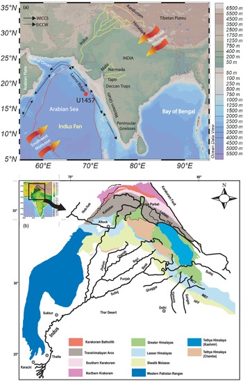
During IODP expedition 355, sedimentary cores were retrieved from the NE Arabian Sea at Sites U1456 and U1457. For this study, the sediment core (1100 m) collected from Site U1457 has been utilized to understand the sediment provenance and hydroclimatic condition over the Indus River Basin since the late Miocene. Site U1457 is situated in the Laxmi Basin, NE Arabian Sea, c. 490 km west of the Indian west coast and 760 km south of the Indus River mouth. Site U1457 is located at 17° 9.95′ N, 67° 55.80′ E and the water depth is 3534 m (Fig. 1a). The Laxmi Basin is separated from the rest of the Arabian Sea by the Laxmi Ridge (continental fragment) in the NE Arabian Sea (Pandey et al. Reference Pandey, Agrawal and Negi1995). The sedimentary succession from IODP Site U1457 has been studied for lithological characteristics, micro-palaeontological and palaeomagnetism for establishing the stratigraphy (Pandey et al. Reference Pandey, Clift, Kulhanek, Andò, Bendle, Bratenkov, Griffith, Gurumurthy, Hahn, Iwai, Khim, Kumar, Kumar, Liddy, Lu, Lyle, Mishra, Radhakrishna, Routledge, Saraswat, Saxena, Scardia, Sharma, Singh, Steinke, Suzuki, Tauxe, Tiwari, Xu, Yu, Pandey, Clift and Kulhanek2016; Routledge et al. Reference Routledge, Kulhanek, Tauxe, Scardia, Singh, Steinke, Griffith and Saraswat2019). Based on the physical properties and lithological characteristics, the Site U1457 sediment core has been broadly categorized into five lithologic units (Pandey et al. Reference Pandey, Clift, Kulhanek, Andò, Bendle, Bratenkov, Griffith, Gurumurthy, Hahn, Iwai, Khim, Kumar, Kumar, Liddy, Lu, Lyle, Mishra, Radhakrishna, Routledge, Saraswat, Saxena, Scardia, Sharma, Singh, Steinke, Suzuki, Tauxe, Tiwari, Xu, Yu, Pandey, Clift and Kulhanek2016). Unit I (depth range from 0 to 74.4 m), deposited during the middle to late Pleistocene, is inferred as hemipelagic sediments deposited under turbidity currents. Unit II (depth range from 74.4 to 385.6 m) was deposited during the early Pleistocene (1.2 to 1.9 Ma). Unit II is interpreted as turbidite series, and the frequency and thickness of the turbidite bed varies downhole. Unit III (depth range from 385.6 to 834.9 m) was deposited during the Pliocene and the late Miocene. In Unit III, two major lithological groups, hemipelagic and redeposited turbidite deposits, are inferred. The hemipelagic and turbidite deposits occur in repeated cycle throughout Unit III. The Unit IV (depth range from 834 to 1062 m) sedimentation occurred during the late Miocene. The dominant lithology in Unit IV is claystone and silty claystone with minor amounts of calcarenite, cacilutite, breccia and limestone. Unit V (depth range from 1062 to 1092 m) was deposited during the Palaeocene. Unit V consists mainly of claystone, silty claystone and sandstone with volcanoclastic breccia and sandstone. Unit V is situated directly at the basaltic basement, and the sediments show the presence of smectite mineral which is the product of chemical weathering of the volcanic rocks. In this study, samples covering 700 m thickness from Site U1457 belonging to the Late Miocene (Unit I to Unit III) are studied for sedimentological, geochemical and environmental magnetic properties. The age–depth model has been developed using biostratigraphy, magnetostratigraphic and isotope (87Sr/86Sr) stratigraphy (Routledge et al. Reference Routledge, Kulhanek, Tauxe, Scardia, Singh, Steinke, Griffith and Saraswat2019). A summary of the age model and tie-points used to calculate sample age is given in Supplementary Table 1 (in the Supplementary Material available online at https://doi.org/10.1017/S0016756822001273). The average sample resolution of this study is ∼104 ka for the Pleistocene, ∼60 ka for the Pliocene and ∼64 ka for the late Miocene.
(a) Location map of drill site U1457 in the NE Arabian Sea, and present-day drainage map of Indus River Basin draining the western Himalayas. The Indus River is the chief contributor of terrestrial sediments to the Indus Fan in the eastern Arabian Sea through its main distributor channels draining the Himalayan and Tibetan Plateau. Schematic representation of wind direction during SW monsoon and NE monsoon seasons is given. WICCS indicates the West Indian Coastal Current in summer and EICCW represents the East Indian Coastal Current in winter. (b) Geological map of Indus River Basin draining western Himalayas. Abbreviations: MCT – Main Central Thrust; MBT – Main Boundary Thrust; HFF – Himadri Frontal Fault; ITSZ – Indus–Tsangpo suture zone.

The Indus River acts as a dominant carrier of detritus from the Western Himalaya through its tributaries (Sutlej, Jhelum, Ravi, Chenab and Beas) to the NE Arabian Sea. The Indus River supplies c. 250 Mt yr−1 sediments to the Arabian Sea (Milliman & Syvitski, Reference Milliman and Syvitski1992). Sediments deposited in the Arabian Sea are the second largest submarine sedimentary body. The Indus Submarine Fan in the Arabian Sea covers an area of 1.1 × 10⁶ km2 having a maximum width of 960 km and a length of 1500 km (Clift et al. Reference Clift, Shimizu, Layne, Blusztajn, Gaedicke, Schluter and Amjad2001; Pandey et al. Reference Pandey, Clift, Kulhanek, Andò, Bendle, Bratenkov, Griffith, Gurumurthy, Hahn, Iwai, Khim, Kumar, Kumar, Liddy, Lu, Lyle, Mishra, Radhakrishna, Routledge, Saraswat, Saxena, Scardia, Sharma, Singh, Steinke, Suzuki, Tauxe, Tiwari, Xu, Yu, Pandey, Clift and Kulhanek2016; Fig. 1). The various bedrock domains that supply the sediment to the Arabian Sea through the Indus River include the Trans-Himalayas and the Greater and the Lesser Himalayas (Fig. 1b; Garzanti et al. Reference Garzanti, Baud and Mascle1987). The lithological heterogeneity belonging to various bedrock ages (Searle, Reference Searle, Yin and Harrison1996; Hodges, Reference Hodges2000; Clift & Webb, Reference Clift, Webb, Treloar and Searle2019) forms the major sediment provenance in the Indus Fan. In addition, the sediments derived from Deccan basalts of Peninsular India are also a contributor to the Indus Fan (Carter et al. Reference Carter, Griffith, Clift, Scher and Dellapenna2020; Khim et al. Reference Khim, Horikawa, Asahara, Kim and Ikehara2020).
Currently, the Indus River Basin receives moisture from both the southwest monsoon and the winter monsoon through westerly jets (Karim & Veizer, Reference Karim and Veizer2002). Precipitation over the mainland is controlled by land–sea pressure gradients during summer and winter that bring the heat and moisture from the Indian Ocean (Cheng et al. Reference Cheng, Zhang, Spötl, Edwards, Cai, Zhang, Sang, Tan and An2012). The link between ISM variability and northern hemisphere summer insolation is also established on an orbital timescale which occurs in conjunction with the cross-equatorial latent heat transport from the southern Indian Ocean (Clemens et al. Reference Clemens, Prell, Murray, Shimmield and Weedon1991; Clemens & Prell, Reference Clemens and Prell2003). The summer monsoon controls the humidity and temperature over the continents, which in turn govern the intensity of chemical weathering and erosion in the source region (Tada et al. Reference Tada, Zheng and Clift2016).
2.b. Surface hydrography and oceanography of the northeastern Arabian Sea
The northern Indian Ocean experiences changes in surface hydrography primarily due to variations in monsoonal wind patterns (Banse, Reference Banse1987; Brock et al. Reference Brock, Sathyendranath and Platt1994; Luis & Kawamura, Reference Luis and Kawamura2004). The clockwise West Indian Coastal Current (WICC) carries high-salinity water from the northern Arabian Sea to the south (Schott, Reference Schott1983; Shetye et al. Reference Shetye, Gouveia, Shenoi, Michael, Sundar, Almeida and Santanam1991; Kumar et al. Reference Kumar, Narvekar, Kumar and Shaji2004) during the summer monsoon season (June–September). As the wind system reverses, the East Indian Coastal Current (EICW) carrying low-salinity water from the northern Bay of Bengal replenishes the SE Arabian Sea, leaving the WICC to flow to the north along the west coast of India (November–February; Shetye et al. Reference Shetye, Gouveia, Shenoi, Michael, Sundar, Almeida and Santanam1991; Kumar et al. Reference Kumar, Narvekar, Kumar and Shaji2004).
3. Methodology
The sediment cores were subsampled at c. 1.5 m intervals (one sample per section). The sediment subsamples (n = 330) were air-dried until complete dryness. For grain-size analysis, an aliquot (1 g) of sediment samples (n = 270) was treated with hydrochloric acid (HCl; 10 %) to remove the carbonates, and then with hydrogen peroxide (H2O2; 30 %) to remove organic matter. The sediment sample was separated through centrifugation after each sample treatment step. Further, the samples were dispersed by adding sodium hexametaphosphate solution (1 %). Grain-size analysis was performed using the Beckman Coulter® Laser Diffraction Particle Size analyser, and sedimentary parameters were determined using the Gradistat® excel spreadsheet (Blott & Pye, Reference Blott and Pye2001). The acid-resistant fraction (ARF) of sediment was estimated gravimetrically after the removal of organic and dissolved inorganic fractions of sediment by chemical treatment with H2O2 and HCl. The repeated centrifugation and decantation of the solution led to an acceptable limit (<10 %) of material loss.
Lithogenous mass accumulation rate (LMAR) is estimated using the following equation provided by Davies et al. (Reference Davies, Kidd and Ramsay1995):
 $${\rm{LMAR}} = {\rm{LSR}}\left( {{\rm{cm}}\,\,{\rm{k}}{{\rm{a}}^{ - 1}}} \right) \times {\rm{ARF}}\left( \% \right) \times {\rm{DBD}}\left( {{\rm{g}}\,{\rm{c}}{{\rm{m}}^{ - 3}}} \right)$$
where LSR is linear sedimentation rate, ARF is acid-resistant fraction of sediment and DBD is average dry bulk density (data taken from Pandey et al. Reference Pandey, Clift, Kulhanek, Andò, Bendle, Bratenkov, Griffith, Gurumurthy, Hahn, Iwai, Khim, Kumar, Kumar, Liddy, Lu, Lyle, Mishra, Radhakrishna, Routledge, Saraswat, Saxena, Scardia, Sharma, Singh, Steinke, Suzuki, Tauxe, Tiwari, Xu, Yu, Pandey, Clift and Kulhanek2016).
For geochemical measurement of major and trace elements, c. 100 mg of dried and finely powdered sediment samples were acid-digested using the microwave digestion system (Speed Wave MWS-3, Analytical Jena, Germany). The sediment samples were decomposed using two steps of acid digestion. The first step includes addition of nitric acid (HNO3, 60 %) and hydrogen peroxide (H2O2, 30 %) with stepwise heating up to 220 °C. Hydrofloric acid (HF; 46 %) was added along with nitric acid (HNO3, 60 %) and hydrogen peroxide (H2O2, 30 %) mixture and again heated up to 220 °C in the microwave digestion system. The clear solutions were transferred to Perfluoroalkoxy alkanes (PFA) vials (Savillex, USA) and evaporated to complete dryness. The insoluble fluoride precipitates were removed using hydrochloric acid (HCl, 36 %). Completely digested sample residues were dissolved in 5 % HNO3 for major and trace element analysis. The major and trace element measurements were carried out using inductively coupled plasma – optical emission spectrometry (ICP-OES) and ICP – mass spectrometry (ICP-MS) respectively using the calibration curve method. The background concentration is corrected using simultaneous measurements of blank and standard (standard bracketing method). The relative standard deviation (r.s.d.) of replicate measurements was within ±3 %. The accuracy of measurements was cross-checked using geochemical reference materials JMS-1 and JMS-2, and was found to be within acceptable limits.
The chemical index of alteration (CIA) was calculated using the following equations (Nesbitt & Markovics, Reference Nesbitt and Markovics1980; Nesbitt & Young, Reference Nesbitt and Young1984). The CIA was further modified to CIA* corrected for carbonates (Fedo et al. Reference Fedo, Nesbitt and Young1995; Singh et al. Reference Singh, Sharma and Tobschall2005; Tripathy et al. Reference Tripathy, Singh and Ramaswamy2014).
 $${\rm{CIA}} = \left( {{\rm{A}}{{\rm{l}}_2}{{\rm{O}}_3}{\rm{/A}}{{\rm{l}}_2}{{\rm{O}}_3} + {\rm{N}}{{\rm{a}}_2}{\rm{O}} + {{\rm{K}}_2}{\rm{O}} + {\rm{CaO^*}}} \right) \times 100$$
 $${\rm{CIA}}^* = \left( {{\rm{A}}{{\rm{l}}_2}{{\rm{O}}_3}{\rm{/A}}{{\rm{l}}_2}{{\rm{O}}_3} + {\rm{N}}{{\rm{a}}_2}{\rm{O}} + {{\rm{K}}_2}{\rm{O}}} \right) \times 100$$
All the major oxides used in the calculation were a molecular proportion of the silicate fraction, and CaO* is the amount of CaO incorporated into the silicate fraction.
The terrigenous magnetic minerals (e.g. iron-bearing oxides and hydroxides) deposited in the form of marine sediments carry information that can be used to reconstruct palaeoclimate, palaeoproductivity and palaeoenvironmental changes (Evans & Heller, Reference Evans and Heller2003). For various environmental magnetic mineral measurements, the sediment samples (3–4 g) were tightly packed in a standard 8 cc cylindrical plastic bottle. The prepared samples were subjected to environmental magnetic measurements like magnetic susceptibility (χlf), anhysteretic remanent magnetization (ARM), saturation isothermal remanent magnetization (SIRM) and its DC demagnetization (Walden, Reference Walden, Walden, Smith and Oldfield1999). Low-frequency magnetic susceptibility (χlf) measurement was carried out with a Bartington magnetic susceptibility meter (model MS2B) operating at a frequency of 0.47 kHz and field intensity of 200 Am−1. The ARM was imparted by exposing the samples to an alternating linearly decaying magnetic field of 100 mT peak field in the presence of a DC bias field of 0.05 mT using a D-2000T alternating field demagnetizer (ASC Scientific, USA). The ARM intensity was measured using the dual-speed JR-6 spinner magnetometer (AGICO, Czech Republic). The ARM is usually expressed as the susceptibility of ARM, i.e. χARM (m3 kg−1) = ARM/39.79 (where 39.79 represents the size of the biasing field at 0.05 mT = 39.79 A m−1). SIRM was induced in a 1 Tesla steady pulse-field using an ASC Scientific IM-10-30 model impulse magnetizer. After SIRM acquisition, backfields of 20, 30, 100 and 300 mT were applied. The soft IRM (SIRM-IRM@-30mT) and hard IRM (SIRM-IRM@-300mT) were then calculated to determine the soft ferrimagnetic magnetite and hard antiferromagnetic haematite respectively. The S-ratio which quantifies the relative proportion of soft and hard magnetic minerals within the sediment sample (Stober & Thompson, Reference Stober and Thompson1979; King & Channell, Reference King and Channell1991; Stoner et al. Reference Stoner, Channell and Hillaire-Marcel1996) was calculated using the expression, S-ratio = IRM@-300mT/SIRM. In general, the S-ratio ≈ 1 indicates a relative abundance of magnetite compared to haematite while the S-ratio < 0.9 indicates a relative abundance of haematite over magnetite in the analysed sample. The magnitudes of measured magnetic parameters were independently sensitive to the concentration of ferrimagnetic and anti-ferromagnetic minerals whereas the calculated interparametric ratio (χARM/χlf) was indicative of magnetic grain size (Thompson & Oldfield, Reference Thompson and Oldfield1986; Maher, Reference Maher1988; Oldfield, Reference Oldfield1991).
4. Results
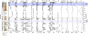
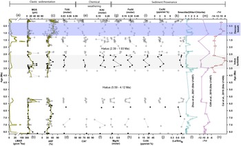
The results of the sedimentological, environmental magnetic, and geochemical dataset for the IODP drill Site U1457 of the Arabian Sea are given in Supplementary Tables 2 and 3 (in the Supplementary Material available online at https://doi.org/10.1017/S0016756822001273). The depth-wise variation (Fig. 2) and temporal variation in lithological, textural, magnetic and geochemical proxies are represented graphically (Figs 3 and 4) to infer the obtained results. The estimated linear mass accumulation rate (LMAR) in the drill site varied from 0.1 g cm−2 ka−1 to 574 g cm−2 ka−1 (avg. 19.2 g cm−2 ka−1). The maximum sedimentation rate was observed at 7.5 Ma (max. 574 g cm−2 ka−1), from 6.1 Ma to 5.6 Ma (avg. 11 g cm−2 ka−1) and from 1.7 Ma to 0.02 Ma (avg. 21 g cm−2 ka−1; Fig. 3). The sediment mean grain size (MGS) was in the range 3.11 µm to 154 µm (avg. 8.03 µm; data point of 154 µm is not shown in the figure). The MGS showed an overall decrease during the late Miocene, except for the period 6.1 Ma to 5.6 Ma during which the MGS was higher. The MGS increased during the Pliocene and the Pleistocene; however, prominent variability was observed during the Pleistocene. The ARF at the drill site varied from 12 % to 97 % (avg. 47 %) of the sediment weight. The ARF was relatively higher during the Pleistocene.
The sedimentological, environmental magnetic and geochemical proxies plotted against the lithostratigraphy of Site U1457. (a) Lithogenous mass accumulation rate (LMAR), percentage of sediment grain-size parameter: (b) clay, (c) silt, (d) sand, (e) calcium carbonate (CaCO3; Khim et al. Reference Khim, Lee, Ha, Park, Pandey, Clift, Kulhanek, Steinke, Griffith, Suzuki and Xu2020b), (f) χlf, (g) χARM, (h) S-ratio, (i) χARM/χlf, (j) branched and isoprenoid tetraether (BIT; Feakins et al. Reference Feakins, Liddy, Tauxe, Galy, Feng, Tierney, Miao and Warny2020), (k) Ti/Al molar, (l) K/Al molar, (m) Chemical Index of Alteration (CIA*), (n) (La/Sm)N and (o) ϵ Nd (Clift et al. Reference Clift, Webb, Treloar and Searle2019) at Site U1457.

(a) Lithogenous mass accumulation rate (LMAR), (b) mean grain size (MGS), (c) acid-resistant fraction (ARF), (d) Ti/Al, (e) Chemical Index of Alteration (CIA*), (f) silicate weathering index, K/Al (molar), (g) Mg/Al (molar), (h) Fe/Al (molar), (i) Cr/Al (ppm/wt %), (j) Co/Al (ppm/wt %), (k) (La/Sm)N, (l) smectite/illite+chlorite (Zhou et al. Reference Zhou, Ireland, Murray and Clift2021) and (m, n) ϵNd from drill sites U1457 (Clift et al. Reference Clift, Webb, Treloar and Searle2019) and U1456 (Cai et al. Reference Cai, Xu, Clift, Lim, Khim, Yu, Kulhanek, Li, Chen and Sun2019), NE Arabian Sea, and comparison with the isotopic composition (ϵNd) of clastic sediments from the same drill site U1457. In (a–c), a five-point moving average of respective data series is plotted in solid dark-green lines; solid black circle indicates the dry condition while empty circle shows the humid condition in the NE Arabian Sea.

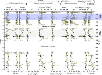
Sedimentary grain size (a–c) indicates clay, silt and sand in %. Magnetic mineral concentration: (d) χlf, (e) χARM and (f) SIRM; magnetic mineralogy: (g) S-ratio, (h) soft IRM and (i) hard IRM. (j) χARM/χlf, interparametric ratio of magnetic data for Indus River Basin record from the eastern Arabian Sea drill site U1457.

The sediment texture in the core was dominated by silty-clay fraction (Fig. 2). The silt fraction varied from 12 to 100 % (avg. 65 %) while the clay fraction varied from 2 to 57 % (avg. 26 %) and sand fraction varied from 0 to 82 % (avg. 8 %). The silt clay fraction of sediment showed long-term increase during the late Miocene, except for the period 6.1 Ma to 5.6 Ma during which the silt clay fraction was lower. During the Pliocene, the silt clay fraction of sediment increased from 4 Ma to 3.6 Ma, after which it showed a declining trend till 2.5 Ma. During the Pleistocene, the silt clay fraction showed general uniform depth distribution, with silt being the dominant grain fraction. The sediment sorting (ϕ) varied from 0.35 to 3.19 (avg. 1.56), skewness (ϕ) varied from −0.34 to 0.56 (avg. 0.17), and the Kurtosis (ϕ) varied from 0.62 to 2.56 (avg. 1.12) at Site U1457. The sorting and skewness indicated poorly to very poorly sorted sediment, possibly due to involvement of different transport agencies.
The index of clastic sediment flux, Ti/Al, showed an overall increase since the late Miocene, with significant decrease during the late Pleistocene (1.6–1.2 Ma) and the Miocene (5.9–5.5 Ma). The silicate weathering proxy, K/Al, varied from 0.13 to 0.21 (avg. 0.18). The K/Al ratio during the late Miocene showed an increase, except for the period 7.5 Ma to 7 Ma during which the K/Al ratio decreased. The K/Al ratio in the Pliocene increased, while it decreased with an observable cyclicity during the Pleistocene (Fig. 3). The chemical index of alteration (CIA) varied from 56 to 76 in the sediment core, with an overall decrease since the late Miocene. The Mg/Al varied from 0.25 to 0.86 (avg. 0.52), Fe/Al varied from 0.17 to 0.44 (avg. 0.30), Co/Al varied from 5.33 to 50.07 (avg. 15.46) and Cr/Al varied from 15.02 to 36.47 (avg. 23.73). The Mg/Al, Fe/Al, Co/Al and Cr/Al showed similar variability, with higher values during the late Miocene (except for the time period from 5.9 to 5.5 Ma) and the Pliocene, and lower values during the Pleistocene (1.9 to 1.2 Ma) and the late Miocene (5.9 to 5.5). Upper continental crust (Taylor & McLennan, Reference Taylor and McLennan1985) normalized (La/Sm)N varied from 0.29 to 1.34 (avg. 0.74). The (La/Sm)N values remained low during the late Miocene. However, slightly higher values were observed at 5.9 to 5.5 Ma and 7 Ma. Consistently higher values of (La/Sm)N were observed during the Pliocene, while (La/Sm)N values declined during the late Pleistocene. Low (La/Sm)N values were observed during 1.2 to 0.42 Ma, after which the values showed an increase. The concentrations of major and trace elements in the sediment core did not show a statistically significant correlation with sediment mean grain size.
χlf, χARM and SIRM varied in the range 3 to 277 (avg. 40), 0.8 to 74 (avg. 16) and 3 to 406 (avg. 56) respectively in the sediment core at Site U1457. The calculated S-ratio varied from 0.5 to 1.0 with an average value of 0.9 in the studied core. The soft IRM and hard IRM varied from 2 to 293 (avg. 43) and 4 to 614 (avg. 46) respectively, while the interparametric ratio (χARM/χlf) varied from 0.6 to 13 (avg. 4). The environmental magnetic parameters (χlf, χARM and SIRM) showed synchronous variation through time in the NE Arabian Sea. Synchronous variability was also observed among S-ratio, soft IRM and hard IRM (Fig. 4). A consistent long-term trend of synchronous variability was also observed between the interparametric ratios (χARM/χlf and χARM/SIRM) and χARM. Therefore, the single interparametric ratio (χARM/χlf) was used to explain magnetic grain size. In general, the data pattern showed an increase in magnetic mineral concentration (χlf) and ferromagnetic minerals (χARM) from the late Miocene to the late Quaternary. The magnetic mineral concentration, magnetic mineral grain size and magnetic mineralogy showed significant variability since the late Miocene (Fig. 4). Based on the magnetic concentration, magnetic grain size and magnetic mineralogy, shifts in sediment erosion and sedimentation pattern were identified, at 7.5 Ma to 7 Ma, 6 Ma to 5.6 Ma, 3.6 Ma to 2.4 Ma, 1.7 Ma to 1.2 Ma, and 1.2 Ma to Recent time (Fig. 4). There was a good correlation (R 2 = 0.735) between χlf and SIRM in the studied sedimentary sequence. The correlation among environmental magnetic parameters and sedimentary mean grain size was poor at study site U1457.
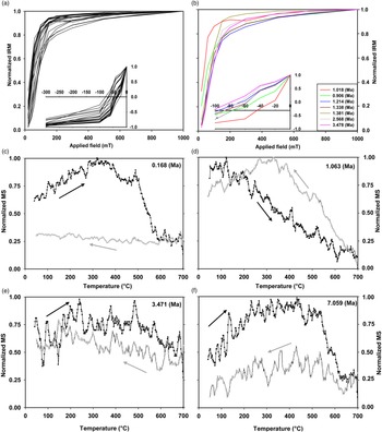
The IRM acquisition curves of samples (n = 16) saturated at higher field of >500 mT (Fig. 5a). The progressive removal of SIRM by applying reverse fields indicated that the remanent coercivity (H cr) varied between c. 25 and 75 mT (inset of Fig. 5a), suggesting that both low-coercivity magnetite and high-coercivity haematite magnetic minerals phases existed (Dunlo & Özdemir, Reference Dunlo and Özdemir1997). On the other hand, the IRM acquisition curves of some sediment samples reached saturation at >750 mT (Fig. 5b). These samples may contain high-coercivity haematite with very high H cr values (45 and 100 mT; inset of Fig. 5b).
IRM acquisition curves for representative sediment samples to identify magnetite and haematite magnetic minerals. The normalized IRM vs applied field (mT) plots (a, b) discriminate the dominant presence of haematite and magnetite minerals in the samples. The χ–T curves indicate presence of both magnetite and haematite during the late Miocene and Pleistocene (c, f). (d, e) show the noise level and the difficult-to-differentiate magnetic mineralogy. The black and grey curves and arrows represent heating and cooling respectively.

The magnetic mineral carriers have been determined by temperature dependence of magnetic susceptibility (χ–T) measurements in selected samples of the sediment core. The representative χ–T curves are shown in Figure 5c–f. Samples with magnetic mineral carriers dominated by Curie temperatures (T c) at ∼580 °C and 685 °C suggested the presence of both magnetite and haematite as the dominant magnetic mineral carriers (Fig. 5c–f). However, some sediment samples did not have clear Curie temperature transitions at 580 °C or 685 °C, suggesting that the data was too noisy and cannot be interpreted (Fig. 5d–e).
5. Discussion
The dataset generated from this study on Site U1457 (Supplementary Table 2 in the Supplementary Material available online at https://doi.org/10.1017/S0016756822001273) has been discussed in conjunction with the published neodymium isotopic dataset (ϵNd; Clift et al. 2019b; Zhou et al. Reference Zhou, Ireland, Murray and Clift2021), CaCO3, TOC (Khim et al. Reference Khim, Lee, Ha, Park, Pandey, Clift, Kulhanek, Steinke, Griffith, Suzuki and Xu2020b Reference Khim, Lee, Ha, Park, Pandey, Clift, Kulhanek, Steinke, Griffith, Suzuki and Xu) and branched and isoprenoid tetra-ether (BIT) datasets (Feakins et al. Reference Feakins, Liddy, Tauxe, Galy, Feng, Tierney, Miao and Warny2020) (i) to check for possible influence of in situ authigenic processes on the proxy signatures, (ii) to determine the sediment provenance in the Indus Fan and (iii) to understand the erosional history of the Indus River Basin and Peninsular India, and its link with summer monsoon which further provides insight into the climate variability over the Indian subcontinent since the late Miocene.
5.a. Depth profile of proxy signatures and their variation with respect to lithostratigraphy
The reliability of proxy for the interpretation of terrestrial processes must be carefully considered as sediments deposited under the influence of turbidity current and autocyclic processes within basin affect the sedimentation rate, sediment sorting and the geochemical proxy signatures. Earlier workers have provided lithostratigraphic framework and inferred the depositional conditions for Site U1457 (Pandey et al. Reference Pandey, Clift, Kulhanek, Andò, Bendle, Bratenkov, Griffith, Gurumurthy, Hahn, Iwai, Khim, Kumar, Kumar, Liddy, Lu, Lyle, Mishra, Radhakrishna, Routledge, Saraswat, Saxena, Scardia, Sharma, Singh, Steinke, Suzuki, Tauxe, Tiwari, Xu, Yu, Pandey, Clift and Kulhanek2016; Routledge et al. Reference Routledge, Kulhanek, Tauxe, Scardia, Singh, Steinke, Griffith and Saraswat2019; Feakins et al. Reference Feakins, Liddy, Tauxe, Galy, Feng, Tierney, Miao and Warny2020). In this study, the depth profiles of proxy signatures along with lithostratigraphy are plotted to differentiate redeposited turbidite deposits (autocyclic process within the basin) and hemipelagic sediments as they have implications on terrestrial hydroclimate and within-basin depositional processes (Fig. 5). The sediment grain size in Unit I is dominated by clay and silt with high percentage of biogenic CaCO3 suggesting hemipelagic sedimentation. Unit II is composed of massive deposits of silty clay interbedded with very thin, grey sandy silt layers. The sandy layers occur in a cyclic manner throughout Unit II. Based on dominance of silt and clay with a consistently low percentage of biogenic carbonates, Unit II is interpreted as turbidite series, and the frequency and thickness of the turbidite bed varies. However, the sediment deposited in Unit II is considered as a product of the sedimentation in a basin plain environment (Pandey et al. Reference Pandey, Clift, Kulhanek, Andò, Bendle, Bratenkov, Griffith, Gurumurthy, Hahn, Iwai, Khim, Kumar, Kumar, Liddy, Lu, Lyle, Mishra, Radhakrishna, Routledge, Saraswat, Saxena, Scardia, Sharma, Singh, Steinke, Suzuki, Tauxe, Tiwari, Xu, Yu, Pandey, Clift and Kulhanek2016). In Unit III, two major lithological groups, hemipelagic and redeposited turbidite deposits, were distinguished. The hemipelagic and turbidite deposits occur in repeated cycle throughout Unit III. The fine-grained and partly biogenic sediments between 385 and 440 m are inferred to be deposited in a basin plain setting or on the edge of an active lobe. Alternating sandy turbidity deposits, below 440 m depth, are deposited in the active lobe environments separated by hemipelagic sediments at depths of 540–500m and 600–670 m (Pandey et al. Reference Pandey, Clift, Kulhanek, Andò, Bendle, Bratenkov, Griffith, Gurumurthy, Hahn, Iwai, Khim, Kumar, Kumar, Liddy, Lu, Lyle, Mishra, Radhakrishna, Routledge, Saraswat, Saxena, Scardia, Sharma, Singh, Steinke, Suzuki, Tauxe, Tiwari, Xu, Yu, Pandey, Clift and Kulhanek2016; Feakins et al. Reference Feakins, Liddy, Tauxe, Galy, Feng, Tierney, Miao and Warny2020). The grain-size data from this study suggests that Unit III is composed of silt and clay with sand fraction (maximum up to 65 %). The sand fraction in Unit III fluctuates, except for the depth from 440 m to 500 m where there is a continuous increase in sand content. Based on sediment grain size and sedimentation rate, the hydrodynamic depositional conditions for these sand deposits were inferred: (i) redeposited turbidite sediments (depth from 440 m to 500 m), and (ii) sandy sediment deposited under high-energy conditions (depth from 500 m to 600 m).
The sandy sediments can be deposited under different hydrodynamic conditions such as (i) high river discharge from the continents, (ii) storm activity within the oceans and (iii) turbidite current deposits, or a combination of all three conditions. The sand-dominated sediment deposits in the depth range from 440 m to 500 m (age 3.5–2.5 Ma) exhibit continuous increase in sand content, low CaCO3, and coarse-grained magnetic minerals. Further, the ϵNd values of these deposits at Site U1457 are more negative than those of sediments deposited at Site U1456. Such heterogeneity in ϵNd among the drill sites could arise from the changes in sediment source. The Indus River sediment provenance in Site U1457 and Deccan-basalt-derived sediment provenance in Site U1456 (Cai et al. Reference Cai, Xu, Clift, Lim, Khim, Yu, Kulhanek, Li, Chen and Sun2019) could be due to autocyclic process within the basin at 440 m to 500 m (age 3.5–2.5 Ma). Therefore, the proxy signatures of sediment deposits in the depth range from 440 m to 500 m (age 3.5–2.5 Ma) could be a reflection of the depositional processes within the basin rather than terrestrial hydroclimatic conditions of the Indus Basin. On the other hand, the sediment deposits in the depth range from 540 m to 600 m (age 6.0–5.6 Ma) are interpreted as turbidites (Pandey et al. Reference Pandey, Clift, Kulhanek, Andò, Bendle, Bratenkov, Griffith, Gurumurthy, Hahn, Iwai, Khim, Kumar, Kumar, Liddy, Lu, Lyle, Mishra, Radhakrishna, Routledge, Saraswat, Saxena, Scardia, Sharma, Singh, Steinke, Suzuki, Tauxe, Tiwari, Xu, Yu, Pandey, Clift and Kulhanek2016; Feakins et al. Reference Feakins, Liddy, Tauxe, Galy, Feng, Tierney, Miao and Warny2020), and alternating clay–silt dominated sediments as hemiplegic sediments. The fluctuating sand fraction of the sediments, low biogenic carbonates, terrestrial organic matter and Indus River provenance (ϵNd) in sediments suggest that the sedimentation occurred in the Indus river mouth or more likely the distal portion of the fan. Therefore, the proxy signatures from Site U1457 probably reflect the terrestrial hydroclimatic conditions and sedimentary provenance in the source area, except for the late Pliocene time interval (3.5–2.5 Ma).
5.b. Suitability of magnetic mineral proxy signatures for palaeo-monsoon reconstruction at Site U1457
The mineral magnetic parameters are sensitive to reductive diagenetic processes in the sediments (Thompson & Oldfield, Reference Thompson and Oldfield1986; Maher & Thompson, Reference Maher and Thompson1992; Verosub & Roberts, Reference Verosub and Roberts1995; Evans & Heller, Reference Evans and Heller2003; Liu et al. Reference Liu, Zhu, Roberts, Li and Chang2004; Reilly et al. Reference Reilly, Bergmann, Weber, Stoner, Selkin, Meynadier, Schwenk, Spiess and France-Lanord2020). The chemical environments (oxic to methanic) and related respiration (aerobic to methanogenesis) processes are well defined in the early diagenetic sediments (Canfield & Thamdrup, Reference Canfield and Thamdrup2009). The magnetic minerals undergo alteration due to the reductive dissolution of Fe-oxyhydroxides, and subsequent formation of Fe-sulphides (pyrites and greigite) in the sulphidic environments due to reaction between dissolved Fe and H2S in the marine sediments (Roberts, Reference Roberts2015). In ferruginous environments, the dissolved iron concentration increases in the pore water and the dissolved iron diffuses upward from pore water to the surface sediments to form oxidized iron phases (magnetite, haematite, oxyhydroxide, ferrihydrite; Berner, Reference Berner1981). Under the oxic–anoxic boundary condition, the magnetotactic bacteria produce authigenic magnetite. This bacteria-mediated authigenic magnetite in sediments exhibits interparametric ratios χARM/χlf greater than 40 and χARM/SIRM greater than 1000 (Dearing, Reference Dearing1999; Walden et al. Reference Walden, Smith and Oldfield1999). Thus, the development of chemical environments and the associated respiration process in sediments alter the source magnetic mineral characteristics. Therefore, it is imperative to assess the effect of diagenetic process on the mineral magnetic proxy signatures in marine sediments before deriving the palaeoenvironmental inferences.
At Site U1457, the interparametric ratios of χARM/χlf and χARM/SIRM in analysed sediments were less than the threshold values (<40 and <1000 respectively), indicating negligible role of magnetotactic bacterial activity in the sediments (Dearing, Reference Dearing1999; Walden et al. Reference Walden, Smith and Oldfield1999). In addition, the magnetic mineral concentration varied positively with detritus content (ARF) at Site U1457, indicating strong source control rather than sedimentary reductive diagenesis. The magnetic versus sedimentary grain-size diagram shows that higher magnetic concentration is associated with lower clay content, which implies that the environmental magnetic signature is primarily controlled by the sediment provenance with minor sedimentary grain-size control at Site U1457 (Supplementary Fig. S1 in the Supplementary Material available online at https://doi.org/10.1017/S0016756822001273).
The minimal diagenetic impact on the magnetic parameters of sediments at Site U1457 can be further elucidated with the existing knowledge database on the study site. The magnetic mineral concentration is expected to be low and the magnetic grain size to be coarser in sediments deposited under reductive diagenetic sediment (Dillon & Bleil, Reference Dillon and Bleil2006; Roberts, Reference Roberts2015). On the other hand, fining of magnetic grain size is expected under strong diagenetic dissolution under sulphidic conditions due to addition of authigenic minerals under euxinic conditions (Garming et al. Reference Garming, Bleil and Riedinger2005). At Site U1457 of the NE Arabian Sea, the depositional environment was mostly oxic and oxic–suboxic since the late Miocene (Alam et al. Reference Alam, Tripti, Gurumurthy, Sohrin, Tsujisaka, Singh, Takano and Verma2022). Though the suboxic depositional conditions were observed for the mid-Pliocene (3.1 Ma to 2.8 Ma) and late Pleistocene (<1.2 Ma), the depositional conditions at Site U1457 were never sulphidic since the late Miocene (Alam et al. Reference Alam, Tripti, Gurumurthy, Sohrin, Tsujisaka, Singh, Takano and Verma2022). Both the reduced oxygen time periods (1.75–1.12 Ma and 3.56–2.58 Ma) and oxic time interval (6.06–5.62 Ma) of Site U1457 reflected similar magnetic signatures (low magnetic concentrations (χlf, χARM and SIRM) and coarser magnetic grain size) and organic preservation less than 1 % (Khim et al. Reference Khim, Lee, Ha, Park, Pandey, Clift, Kulhanek, Steinke, Griffith, Suzuki and Xu2020b). The mineralogy was dominated by high-coercivity magnetic minerals (haematite; S-ratio < 0.9) and lower bacterial magnetite activity (χARM/χlf and χARM/SIRM values below the threshold value; Dearing, Reference Dearing1999; Walden et al. Reference Walden, Smith and Oldfield1999). Further, the interstitial water chemistry suggested that the sulphate reduction zone was located up to 54 meters below sea floor (mbsf) of Site U1457 sediments (Pandey et al. Reference Pandey, Clift, Kulhanek, Andò, Bendle, Bratenkov, Griffith, Gurumurthy, Hahn, Iwai, Khim, Kumar, Kumar, Liddy, Lu, Lyle, Mishra, Radhakrishna, Routledge, Saraswat, Saxena, Scardia, Sharma, Singh, Steinke, Suzuki, Tauxe, Tiwari, Xu, Yu, Pandey, Clift and Kulhanek2016; Carter et al. Reference Carter, Griffith and Scher2017). These findings confirm that the magnetic mineral signatures are largely controlled by the change in magnetic mineral provenance rather than reductive diagenesis for the study period at Site U1457. Moreover, the LMARs, sediment texture and geochemical parameter at Site U1457 showed temporal variation coinciding with global climatic events as well as provenance change in the Indus Fan. Thus, the measured magnetic proxies in this study are useful in exploring the long-term sediment sources to Site U1457 of the Laxmi Basin, and the connection of Indian subcontinental erosion and monsoonal climate evolution since the late Miocene.
5.c. Provenance of sediments at Site U1457 of the Laxmi Basin
The environmental magnetic and geochemical characteristics of sediments have been used to infer the Indus Fan sediment provenance since the late Miocene. The rationale for using environmental magnetism for provenance tracing includes (i) the major source of Indus Fan sedimentation is through the Indus River with a minor contribution from primitive igneous rocks derived from Deccan Province / Trans-Himalayas, and (ii) the magnetic mineral concentration of primitive igneous rocks (mafic rocks) is higher than that of felsic rocks, owing to differences in abundance of ferrimagnetic and diamagnetic minerals (Clark & Emerson, Reference Clark and Emerson1991; Sebastian et al. Reference Sebastian, Nath, Ramaswamy, Mascarenhas-Pereira, Yazing, Apurva, Linsy, Kocherla, Miriyala and Rao2019). Therefore, the erosional products of mafic and felsic rocks carry differing magnetic mineral concentrations and mineralogy. An understanding of sediment provenance is a prerequisite for robust inferences on hydroclimatic and palaeoenvironmental conditions in the catchment area. This is because the heterogeneity in lithological compositions and their contrasting response to hydroclimatic changes lead to misleading palaeoclimatic inferences (Weltje & von Eynatten, Reference Weltje and von Eynatten2004).
Earlier studies on the sediment provenance at IODP drill Sites U1456 and U1457 have revealed that the Indus River is the primary contributor of sediments to the drill sites (Clift et al. Reference Clift, Webb, Treloar and Searle2019; Khim et al. Reference Khim, Lee, Ha, Park, Pandey, Clift, Kulhanek, Steinke, Griffith, Suzuki and Xu2020b Reference Khim, Horikawa, Asahara, Kim and Ikehara). Further, the isotopic (87Sr/86Sr and ϵNd) tracing of Indus Fan sediment provenance revealed a shift in regional catchment erosion from Karakoram during the late Miocene (∼9.5 Ma) to the Himalayas owing to its basin tectonics and monsoon strength (Clift & Blusztajn, Reference Clift and Blusztajn2005; Clift et al. Reference Clift, Webb, Treloar and Searle2019). However, an additional source of primitive igneous rock-derived sediments from either Deccan basalts or the Trans-Himalayan region was observed at the drill sites (Cai et al. Reference Cai, Xu, Clift, Lim, Khim, Yu, Kulhanek, Li, Chen and Sun2019; Chen et al. Reference Chen, Xu, Clift, Lim, Khim and Yu2019; Khim et al. Reference Khim, Horikawa, Asahara, Kim and Ikehara2020a Reference Khim, Horikawa, Asahara, Kim and Ikehara). The clay mineralogy (smectite / chlorite + illite ratio), magnetic susceptibility and isotopic (87Sr/86Sr and ϵNd) studies on IODP drill sites U1456 and U1457 have pinpointed the source of primitive igneous rock sediments to Deccan Province, particularly during the Pliocene (3.5 Ma) and the Pleistocene (1.2 Ma to Recent; Cai et al. Reference Cai, Xu, Clift, Lim, Khim, Yu, Kulhanek, Li, Chen and Sun2019; Chen et al. Reference Chen, Xu, Clift, Lim, Khim and Yu2019; Yu et al. Reference Yu, Colin, Wan, Saraswat, Song, Xu, Clift, Lu, Lyle, Kulhanek, Hahn, Tiwari, Mishra, Miska and Kumar2019; Khim et al. Reference Khim, Horikawa, Asahara, Kim and Ikehara2020a Reference Khim, Horikawa, Asahara, Kim and Ikehara). Further, the contribution of sediments from the Deccan basalt to IODP 355 site U1456 in the NE Arabian Sea have increased during the Pliocene (3.5 Ma) and the Pleistocene (1.2 Ma to Recent; Cai et al. Reference Cai, Xu, Clift, Lim, Khim, Yu, Kulhanek, Li, Chen and Sun2019; Yu et al. Reference Yu, Colin, Wan, Saraswat, Song, Xu, Clift, Lu, Lyle, Kulhanek, Hahn, Tiwari, Mishra, Miska and Kumar2019; Carter et al. Reference Carter, Griffith, Clift, Scher and Dellapenna2020) as a consequence of the weakened ISM and southward migration of the ITCZ (Carter et al. Reference Carter, Griffith, Clift, Scher and Dellapenna2020).
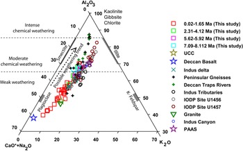
In this study, the A–CN–K (Al2O3–(CaO* + Na2O)–K2O) ternary diagram has been plotted to infer the weathering pattern and possible sediment source at Site U1457 (Fig. 6). The plot suggests that the major and trace elements were supplied by clastic sediments derived from the Indus River and the Peninsular Indian Rivers at Site U1457. The relative enrichment of Al and depletion of Ca, K and Na in the sediments of Site U1457 indicated the relative intensity of weathering in the source catchment area. The CIA* values (varying between 54 and 78) suggested low to moderate chemical weathering of source rocks. In the A–CN–K plot, the majority of the samples were plotted along the weathering trend line parallel to the A–CN axis. This indicated the possible origin of sediments from plagioclase mineral-bearing source rocks, mainly the granites and gneisses. The samples belonging to the late Miocene and the Pliocene were plotted above the upper continental crust (UCC) and altered Post-Archaean Australian Shale (PAAS) values, indicating the possible intense weathering of felsic rocks. On the other hand, the Pleistocene (excluding the time period from 1.9 to 1.2 Ma) sediments fall close to basalt rocks, indicating the possible origin of sediments from basaltic rocks.
Geochemical parameters plotted for provenance discrimination diagram. The A–CN–K plot suggests the sediment mainly derived through the Indus River (granitic composition) with minor contribution from Narmada, Tapti (Deccan basalt). Geochemical data is compared with existing studies on the Indus catchment: Indus tributaries (Alizai et al. Reference Alizai, Carter, Clift, Van Laningham, Williams and Kumar2011); Indus canyon (Li et al. Reference Li, Clift, Böning, Blusztajn, Murray, Ireland and Giosan2018); Indus delta (Clift et al. Reference Clift, Giosan, Carter, Garzanti, Galy, Tabrez, Rabbani and Clift2010); Peninsular gneisses and Deccan Traps rivers (Kurian et al. Reference Kurian, Nath, Kumar and Nair2013); granite (Sharma & Rajamani, Reference Sharma and Rajamani2000 Reference Sharma and Rajamani); Deccan basalt (Peng et al. Reference Peng, Mahoney, Hooper, Harris and Beane1994); upper continental crust (UCC) and Post-Archaean Australian Shale (PAAS) (Taylor & McLennan, Reference Taylor and McLennan1985); IODP Site U1457 and U1456 (Zhou et al. Reference Zhou, Ireland, Murray and Clift2021). For interpretation of the references to colour in the legend, the reader is referred to the web version of this article.

The major-element (Fe/Al, Mg/Al, Ti/Al), trace-element (Cr/Al, Co/Al), chondrite-normalized rare earth element (La/Sm)N and published isotopic proxy data (Cai et al. Reference Cai, Xu, Clift, Lim, Khim, Yu, Kulhanek, Li, Chen and Sun2019; Zhou et al. Reference Zhou, Ireland, Murray and Clift2021) from IODP Sites U1457 and U1456 have been used to decipher the sediment provenance in the NE Arabian Sea (Figs 3 and 6). In general, the K/Al, Mg/Al and Fe/Al values indicate relative depletion of mobile elements in sediments during weathering (Nesbitt & Markovics, Reference Nesbitt and Markovics1980). However, these geochemical proxies are influenced by sediment provenance, degree of chemical alteration and hydraulic sediment sorting (Fralick & Kronberg, Reference Fralick and Kronberg1997; Wan et al. Reference Wan, Clift, Zhao, Hovius, Munhoven, France-Lanord, Wang, Xiong, Huang, Yu, Zhnag, Wentao, Zhang, Li and Li2017). Therefore, these geochemical proxies should be carefully analysed for possible control of weathering, provenance and hydraulic sorting (Wan et al. Reference Wan, Clift, Zhao, Hovius, Munhoven, France-Lanord, Wang, Xiong, Huang, Yu, Zhnag, Wentao, Zhang, Li and Li2017). The major elements (e.g. K, Mg, Fe and Al) are enriched in clay minerals. The retention of these elements depends on mineral phases and their specific grain size (Nath et al. Reference Nath, Gupta, Mislankar, Rao, Parthiban, Roelandts and Patil2005; Wan et al. Reference Wan, Clift, Zhao, Hovius, Munhoven, France-Lanord, Wang, Xiong, Huang, Yu, Zhnag, Wentao, Zhang, Li and Li2017). In particular, K is enriched in illite rather than in smectite while Mg and Fe are enriched in chlorite and smectite (Wan et al. Reference Wan, Clift, Zhao, Hovius, Munhoven, France-Lanord, Wang, Xiong, Huang, Yu, Zhnag, Wentao, Zhang, Li and Li2017; Cai et al. Reference Cai, Xu, Clift, Khim, Lim, Yu, Kulhanek and Li2020). The values of Mg/Al and Fe/Al are proportionally related to the relative abundance of smectite content within the clay mineral assemblage. On the other hand, compatible elements such as Cr, Co and Sm are preferentially associated with early crystallized magmatic minerals (mafic) while the La is associated with later crystallized felsic minerals. The Al-normalized elemental ratios of trace metals (Cr and Co) and chondrite-normalized rare earth element ratio (La/Sm)N could be used to decipher the sediment provenance in the marine sediments.
At Site U1457, the elemental ratios show statistically insignificant correlation with mean grain size, suggesting negligible role of hydraulic sorting. Therefore, these geochemical proxies could be used to track the sediment provenance and weathering conditions in the catchment area. The Indus River-supplied Himalayan sediment is rich in illite and smectite (Rao & Rao, Reference Rao and Rao1995; Kessarkar et al. Reference Kessarkar, Rao, Ahmad and Babu2003; Alizai et al. Reference Alizai, Hillier, Clift, Giosan, Hurst, Van Laningham and Macklin2012), and the Peninsular River-supplied Deccan Trap sediment is rich in smectite (Debrabant et al. Reference Debrabant, Krissek, Bouquillon, Chamley, Prell and Niitsuma1991; Rao & Rao, Reference Rao and Rao1995; Kessarkar et al. Reference Kessarkar, Rao, Ahmad and Babu2003; Phillips et al. Reference Phillips, Johnson, Underwood, Guo, Giosan and Rose2014). Therefore, the K/Al (associated with illite), Mg/Al and Fe/Al (associated with smectite), Cr/Al (associated with primary mafic minerals) and La/SmN (relative dominance of felsic to mafic mineral source) values were used in this study to decipher the Himalayan and Deccan Province sediment in the NE Arabian Sea. At Site U1457, the elemental composition of sediment does not show significant variation during the late Miocene (Fig. 3). The sediment composition was characterized by low Mg/Al, Fe/Al, Cr/Al and high K/Al and (La/Sm)N indicating homogeneous felsic sedimentary source, possibly derived from the Indus River. On the other hand, the elemental ratios show an increase in Mg/Al, Fe/Al, Cr/Al, Co/Al and decrease in K/Al and (La/Sm)N during the late Pleistocene (between 1.2 and 0.25 Ma), which suggests possible dominance of primitive igneous source rock derived sediments (Fig. 3).
The sediments derived through primitive igneous rocks (mafic rocks) exhibit higher magnetic mineral concentration due to the presence of Fe-oxides, and mineralogy is expected to be dominated by magnetite and titanomagnetite (Rao & Wagle, Reference Rao and Wagle1997; Kumar et al. Reference Kumar, Rao, Patil, Kessarkar and Thamban2005; Sangode et al. Reference Sangode, Sharma, Mahajan, Basavaiah, Srivastava, Gudadhe, Meshram and Venkateshwarulu2017; Sebastian et al. Reference Sebastian, Nath, Ramaswamy, Mascarenhas-Pereira, Yazing, Apurva, Linsy, Kocherla, Miriyala and Rao2019). The magnetic susceptibility is generally the result of sediment provenance, sediment grain size and sediment diagenesis. At Site U1457, the effect of sediment grain size and early diagenesis was minimal (see Section 5.a), and thus, magnetic susceptibility was found to be largely controlled by sediment provenance. The mafic source rocks are more prone to weathering than felsic rocks under similar morphoclimatic settings (Dupré et al. Reference Dupré, Dessert, Oliva, Goddéris, Viers, François, Millot and Gaillardet2003; Gurumurthy et al. Reference Gurumurthy, Balakrishna, Riotte, Braun, Audry, Shankar and Manjunatha2012). At Site U1457, the higher magnetic mineral concentration (high χlf, χARM and SIRM), high detritus (ARF %) and magnetite–titanomagnetite mineralogy S-ratio > 0.9) coincided with low (La/Sm)N and high Mg/Al and Fe/Al values, suggesting dominance of mafic magnetic mineral sources during the Pleistocene (Figs 2 and. 3). This observation is consistent with previous studies suggesting changes in provenance during the Pleistocene (Cai et al. Reference Cai, Xu, Clift, Lim, Khim, Yu, Kulhanek, Li, Chen and Sun2019; Yu et al. Reference Yu, Colin, Wan, Saraswat, Song, Xu, Clift, Lu, Lyle, Kulhanek, Hahn, Tiwari, Mishra, Miska and Kumar2019; Carter et al. Reference Carter, Griffith, Clift, Scher and Dellapenna2020). The felsic and mafic source rock sediments have distinct χlf and SIRM signatures. The positive correlation between χlf and SIRM of sediments from Site U1457 reflects felsic source rock magnetic signatures. However, few samples belonging to the Pleistocene exhibit mafic source rock magnetic signatures (higher χlf and SIRM). These samples exhibit higher S-ratio, interparametric ratio (high χARM/χlf) and the presence of magnetite–titanomagnetite (Fig. 4). Further, the χ–T curves and remnant coercivity (Hcr) measurements of the selected samples with suspected mafic rock contribution reflected the presence of magnetite and haematite mineral phases during the Quaternary and the late Miocene time period (Figs 4 and 5c–f), suggesting the two possible mineral sources at the study site. However, the environmental study can be useful for inferring sediment source at Site U1457.
Interestingly, at Site U1457, higher values of the χlf and SIRM with titanomagnetite–magnetite were also observed during the late Miocene and Pliocene, which pointed to a possible mafic rock sediment provenance. The Deccan basalt / Trans-Himalayan mafic rocks generally exhibit positive ϵNd values, and sedimentary and plutonic rocks of the Indus River exhibit negative ϵNd values (Clift et al. Reference Clift, Lee, Hildebrand, Shimizu, Layne, Blusztajn, Blum, Garzanti and Khan2002b, Clift, Reference Clift2006). The negative ϵNd values, smectite clay mineralogy and slightly lower ratios of (La/Sm)N, Fe/Al, Cr/Al and Co/Al are observed during the high humid climatic phases. However, these elemental ratios and ϵNd values are slightly intermediate between felsic and mafic composition. The intermediate sediment geochemical composition could emanate when there is mixing of mafic and felsic source sediments. Though the Indus River Basin is dominantly of felsic composition, the Trans-Himalayan region of the western Himalayas is composed of mafic lithology. The weathering and erosion of Indus River Basin rocks (felsic as well as mafic) could lead to intermediate composition with slight mafic bias.
5.d. Erosion and monsoon since the late Miocene
Silicate weathering intensity and erosional records have been useful in reconstructing the monsoon in the South Asian region. On a global scale, the warm temperature and high surface runoff lead to intense silicate weathering (West et al. Reference West, Galy and Bickle2005; Gurumurthy et al. Reference Gurumurthy, Balakrishna, Riotte, Braun, Audry, Shankar and Manjunatha2012) and erosion (Gaillardet et al. Reference Gaillardet, Dupré, Louvat and Allegre1999; Millot et al. Reference Millot, Gaillardet, Dupré and Allègre2003). The dependence of weathering and erosion processes on the hydroclimate (runoff and temperature), lithology and geomorphology has been the basis for using sedimentary archives for palaeoclimate reconstruction of different geological timescales (West et al. Reference West, Galy and Bickle2005; Lara et al. Reference Lara, Buss and Pett-Ridge2018).
The silicate weathering, erosion and sedimentation pattern at Site U1457 of the Laxmi Basin show high temporal variation since the late Miocene, implying changes in hydroclimatic conditions in the drainage area. At Site U1457, the sedimentary and geochemical record shows moderate chemical weathering and low detrital supply during the late Miocene, except for the period between 7.6–7.5 Ma and 6.0–5.6 Ma where high clastic sedimentation (high LMAR) is observed. The high clastic sedimentation during 7.6–7.5 Ma at Site U1457 is also characterized by coarse sediment grains and higher magnetic susceptibility (Weber et al. Reference Weber, Wiedicke-Hombach, Kudrass and Erlenkeuser2003; Reilly et al. Reference Reilly, Bergmann, Weber, Stoner, Selkin, Meynadier, Schwenk, Spiess and France-Lanord2020). The geochemical data suggests an increase in altered sediment supply at 7.0 Ma implying humid climatic conditions, while the environmental magnetic and sediment texture data does not reflect humid climatic conditions in the region. An additional dataset is needed to ascertain the hydroclimatic conditions at 7 Ma. Therefore, this study infers that the long-term trend in hydroclimatic conditions in the Indus River Basin during the late Miocene is relatively drier except for the period from 6.0 to 5.6 Ma. The long-term drying with decline in the monsoon during the late Miocene is consistent with the global cooling. In contrast, the high sedimentation rate (high LMAR) during 6.0–5.6 Ma is associated with altered sediments having fluctuating clay–silt sediments and low magnetic susceptibility (Fig. 4). These sediments are deposited in a distal setting of the fan (Clift et al. Reference Clift, Kulhanek, Zhou, Bowen, Vincent, Lyle and Hahn2020). The humid climatic conditions during 6.0 to 5.6 Ma induced chemical alteration of sediments, and enhanced erosion of continental rocks, suggesting that the sediments are produced under transport-limited conditions. The chemically altered sediments (CIA, low K/Al and Mg/Al), elevated clastic flux (high Ti/Al) and high sedimentation rate (LMAR) were observed during the time interval 6.0–5.6 Ma (Fig. 3). Further, a coarsening of grain size possibly under high-energy conditions and higher detrital sediments was also observed for the same time interval. The environmental magnetic characteristics such as increased magnetic mineral concentration (i.e. high χlf, XARM and SIRM), finer to coarser magnetic grain size (i.e. low interparametric ratio, χARM/χlf), and high proportion of magnetite relative to haematite mineral (i.e. S-ratio > 0.9) are also consistent with geochemical and sedimentological observations (Fig. 4). These observations suggest moderate alteration of the sediments with higher erosion in the catchment under transport-limited conditions during 6.0–5.6 Ma.
As discussed earlier, the Pliocene sedimentary record of Site U1457 is primarily composed of redeposited turbidites derived from the Indus. An exception to this is hemipelagic sediments belonging to the depth range 500–530 m (age 4.12 to 3.4 Ma; discussed in Section 5.c). The mid-Pliocene hemipelagic sediments of Site U1457 (depth range 500–530 m; age 4.12 to 3.4 Ma) show intense silicate weathering indicating humid climatic conditions (Fig. 3). The humid hydroclimatic conditions during the mid-Pliocene (4.12 to 3.4 Ma) could be inferred from the proxy record of increase in chemical weathering (high CIA and lower K/Al) and higher clastic flux (increased ARF %, Ti/Al ratio, and a corresponding increase in LMAR). Further, the higher magnetic concentration, magnetic mineralogy (dominated by haematite relative to magnetite) and magnetic grain size (finer to coarser) in the mid-Pliocene sediment record suggest humid hydroclimatic conditions (Fig. 4). The formation of permanent ice caps in the northern hemisphere (Raymo, Reference Raymo1994; Zhang et al. Reference Zhang, Ji, Balsam, Liu and Chen2009), caused by tectonically induced changes in oceanic gateways, played an important role in strengthening the ISM. The mid-Pliocene witnessed worldwide changes in palaeoceanography, possibly driven by the tectonic rearrangement of seaways, and subsequent blockage of the heat transfer among the world oceans, thus altering the thermocline structure of the Indo-Pacific Ocean (Karas et al. Reference Karas, Nürnberg, Gupta, Tiedemann, Mohan and Bickert2009, Reference Karas, Nürnberg, Tiedemann and Garbe-Schönberg2011, Reference Karas, Nürnberg, Bahr, Groeneveld, Herrle, Tiedemann and Demenocal2017; Nie et al. Reference Nie, Stevens, Song, King, Zhang, Ji, Gong and Cares2014; Herbert et al. Reference Herbert, Lawrence, Tzanova, Peterson, Caballero-Gill and Kelly2016).
The Pleistocene sedimentary record (Figs 3 and 4) of the NE Arabian Sea at Site U1457 shows an overall increase in mean grain size, enhanced detrital supply (high ARF % and Ti/Al) and high magnetic mineral content (high χlf) with dominance of magnetite mineralogy (S-ratio > 0.9). However, during the same period, the chemical weathering is observed to be moderate (relatively lower values of CIA* and higher values of K/Al). These proxy signatures indicate an increase in the physical weathering and low–moderate chemical weathering in the catchment. The Pleistocene sediment exhibits enhanced physical erosion with higher detrital supply to Site U1457, particularly during the interglacial periods (Khim et al. Reference Khim, Horikawa, Asahara, Kim and Ikehara2020a Reference Khim, Lee, Ha, Park, Pandey, Clift, Kulhanek, Steinke, Griffith, Suzuki and Xu). These proxies suggest that the moisture content during the Pleistocene is variable, and the interplay between monsoon and weathering affects the sediment provenance (Kulkarni et al. Reference Kulkarni, Sangode, Bloemendal, Meshram and Suresh2015; Badesab et al. Reference Badesab, Gaikwad, Nath, Venkateshwarlu, Aiswarya, Tyagi, Salunke, Fernades, Kadam, Sangode, Sardar and Prabhu2021). In particular, the interglacial or strengthened summer monsoon period shows highly altered sediments from the Indus region with additional input from the Deccan basalts. On the other hand, sediments during the glacial periods of the Pleistocene are less altered and are transported from the Indus River Basin.
Within the Pleistocene, the timespan 1.8–1.2 Ma shows a significant increase in sedimentation rate (high LMAR but low to moderate detrital flux), and intense chemical weathering (K/Al and CIA = 69–78) indicating either enhanced erosion under humid climatic conditions or enhanced recycling through the Indus River system. For the same period, the environmental magnetic data shows low magnetic mineral concentration (i.e. low χARM, χlf and SIRM) with coarser magnetic grains (i.e. reduced χARM/χlf) and magnetic mineralogy dominated by haematite (S-ratio < 0.9). Interestingly, in spite of glacial and interglacial conditions, the above time period shows relatively lower variability in proxy signatures, suggesting a relatively homogeneous sediment source and shift in hydroclimatic conditions during the Pleistocene. The interval 1.8–1.2 Ma also witnessed a high rate of sedimentation in the eastern Arabian Sea. The high sedimentation rate is interpreted as turbidite deposits (Pandey et al. Reference Pandey, Clift, Kulhanek, Andò, Bendle, Bratenkov, Griffith, Gurumurthy, Hahn, Iwai, Khim, Kumar, Kumar, Liddy, Lu, Lyle, Mishra, Radhakrishna, Routledge, Saraswat, Saxena, Scardia, Sharma, Singh, Steinke, Suzuki, Tauxe, Tiwari, Xu, Yu, Pandey, Clift and Kulhanek2016), and these deposits contain terrestrial organic matter dominated by C-3 plants (Khim et al. Reference Khim, Lee, Ha, Park, Pandey, Clift, Kulhanek, Steinke, Griffith, Suzuki and Xu2020b). A recent study suggested that the strengthening of winter monsoon and the weakening of summer monsoon favour the growth of C-3 vegetation (Basu et al. Reference Basu, Ghosh and Sanyal2019). The changes in Arabian Sea surface hydrography and productivity induced by the strengthening of the winter monsoon were reported earlier for the same period (1.8–1.6 Ma; Satpathy et al. Reference Satpathy, Steinke and Singh2020). Therefore, it is possible that the strengthened winter monsoon during 1.8–1.2 Ma has brought altered sediments through the Indus River to Site U1457 of the Laxmi Basin.
The change in lithofacies and textural characteristics at depth 74.4 mbsf (~1.2 Ma) of site U1457 (transition in lithofacies from Unit II to Unit I) is interpreted as a result of lateral migration depocentre or dynamics of the channel levee system (Pandey et al. Reference Pandey, Clift, Kulhanek, Andò, Bendle, Bratenkov, Griffith, Gurumurthy, Hahn, Iwai, Khim, Kumar, Kumar, Liddy, Lu, Lyle, Mishra, Radhakrishna, Routledge, Saraswat, Saxena, Scardia, Sharma, Singh, Steinke, Suzuki, Tauxe, Tiwari, Xu, Yu, Pandey, Clift and Kulhanek2016). However, transition from Unit II to Unit I is also associated with a shift in sediment provenance from Indus-dominated sediments to Deccan-basalt-dominated sediments. Dominance of mafic sediment provenance is inferred for the period from 1.2 to 0.25 Ma based on an overall enrichment of major and trace elements, smectite clay mineralogy and radiogenic ϵNd values (discussed in Section 5c). For the same period, the chemical alteration of sediments has reduced (low CIA and higher K/Al), suggesting weaker monsoon conditions in the region. The weaker monsoon in the Indus catchment is also reported from Site U1456 for the period from 1.1 to 0.1 Ma (Lu et al. Reference Lu, Liu, Cheng, Feng, Zhang, Wang, Hu, Zhao, Ji, Xu, Yu, Kulhanek, Pandey and Clift2020). The migration of the ITCZ from northern to southern latitudes shifts the rainfall distribution towards the peninsular region, leading to weathering of Deccan Province in Peninsular India. Therefore, the monsoon strength is likely to exhibit significant control over the Indus Fan sedimentation. Thus, the geochemical and environmental magnetic characterization of sediments from Site U1457 in the NE Arabian Sea demonstrates the link between monsoon strength and erosion over the Indian subcontinent since the late Miocene.
6. Conclusions
The link between the erosional history of the western Himalayas and the ISM evolution since the late Miocene has been explored in this study using marine sediment records from the Indus Fan in the NE Arabian Sea at Site U1457 of the Laxmi Basin collected during IODP Expedition 355. The geochemical, environmental magnetic and sedimentological signatures of the NE Arabian Sea sediments indicated that the climatic condition in the western Himalayas during the late Miocene was predominantly arid, except for the humid interval from 6.1 to 5.6 Ma. The mid-Pliocene and the Pleistocene climate in the western Himalayas were observed to be humid. The climatic condition during the mid-Pleistocene period (1.9 Ma–1.2 Ma) was observed to be intensely humid. The observed cyclicity in the measured proxies during the Pleistocene suggested variability in the moisture content during its sedimentation which further coincided with the glacial and interglacial moisture variability. The study indicated that the dominant source of sediment in the NE Arabian Sea at Site U1457 during the late Miocene and the Pliocene was the Indus River while the Pleistocene sediments had characteristics of mixed sources derived from the Indus River and the western Indian Peninsular Rivers. This study revealed that the sediments of Site U1457 in the NE Arabian Sea were derived additionally from the Deccan basalts during the weaker summer monsoonal conditions of the Pleistocene (1.2 to 0.25 Ma).
Supplementary material
To view supplementary material for this article, please visit https://doi.org/10.1017/S0016756822001273
Acknowledgements
This work is funded by IODP-India and NCPOR, Goa under the Post-Cruise Research Funding Scheme (Grant No. NCAOR/IODP/20-15/15(V)) to GPG. Dr Vandana Prasad (Director, BSIP), Dr Anupam Sharma (Senior Scientist, BSIP) and Dr Binita Phartiyal (Senior Scientist, BSIP) are thanked for support and encouragement at various stages of this work. GPG thank the Indian National Science Academy (INSA) for the award of the ‘Establishment of Young Researcher – 2018’ fellowship under the INSA–JSPS bilateral Program. TM thanks the INSA and the Department of Science and Technology (DST) for the INSPIRE Faculty fellowship. The authors acknowledge JOIDES RESOLUTION, the International Ocean Discovery Program (IODP), Dr Denise K Kulhanek (Expedition Manager) and all shipboard scientists and crew members of the IODP-355 expedition for their support during sample collection. TR acknowledges the support from the Council of Scientific and Industrial Research (CSIR) for Emeritus Scientist (Grant No. 21(1041)/2017/EMR -II). The authors thank Prof. Peter D Clift (Editor-in-Chief), and three anonymous reviewers for their constructive comments on the initial version of the manuscript. This is BSIP contribution No. 55/2020-2021.
Conflict of interest
None.