Teotihuacan, the capital of a powerful regional state, thrived in the northeastern Basin of Mexico from about a.d. 1 to 600/650. Its urban population, an estimated 80,000 to 125,000 people (Cowgill Reference Cowgill, Cobean, Mastache, Cook and Hirth2008:97; Millon Reference Millon, Yoffee and Cowgill1988:102) was exceptionally large and dense compared to settlements in the surrounding region and to early cities in many other parts of the world. A high proportion of Teotihuacan's food producers likely resided within the 20 km2 area identified as its urban zone (Cowgill Reference Cowgill2004:533). Teotihuacan's urban population was provisioned in part, however, with food, firewood, raw materials, and other resources derived from beyond the city limits (Cowgill Reference Cowgill, Cobean, Mastache, Cook and Hirth2008:97; Millon Reference Millon, Yoffee and Cowgill1988:136; Sanders et al. Reference Sanders, Parsons, Logan and Wolf1976:172, Reference Sanders, Parsons and Santley1979:127).
Archaeological research in the region surrounding Teotihuacan has benefited from thorough attention to settlement data. The Basin of Mexico Settlement Survey (Sanders et al. Reference Sanders, Parsons and Santley1979; Sanders Reference Sanders, Sabloff and Sabloff1981:150) covered 3500 km2 and identified many settlements that were contemporaneous with Teotihuacan. Few Teotihuacan-period sites outside of the Teotihuacan Valley have been excavated since these pioneering surveys were undertaken, however, and most research concerning the Teotihuacan state has focused on the urban center. As a result, Teotihuacan's intraregional structure has remained underexamined. Teotihuacan was certainly a vibrant city, but it must also be understood as a regional phenomenon that included the city and its periphery as well as more distant rural settlements and populations as part of its sociospatial landscape. These rural components must be investigated in order to achieve a balanced and more comprehensive model of its demographic expansion, political and economic reach, and dynamic internal and intraregional social organization.
Some important exceptions to this urban-centric perspective have contributed significantly to the question of Teotihuacan's economic and political relationships with surrounding settlements. For example, Cabrera Cortés (Reference Cabrera Cortés2011) recently investigated the socioeconomic structure of communities that occupied the city's outer margins. Charlton's work (1987, 1991, Reference Charlton2000) on rural sites and trade routes in the Teotihuacan Valley and adjacent areas has led to a firmer grasp on exchange and the settlement organization of rural populations. Recent research by García Chávez and colleagues (García Chávez Reference García Chávez1991; García Chávez et al. Reference García Chávez, Cabezas, Vélez Saldaña, Gallut and Peralta2005) and Gorenflo (Reference Gorenflo and Storey2006) represents a return to regional inquiry that is vital for understanding how Teotihuacan—the center—related to the region that it dominated.
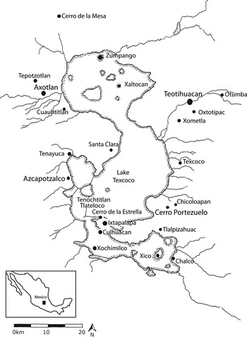
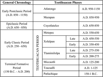
With these objectives in mind I consider Teotihuacan's relationship with two coeval rural settlements: Axotlan, located in the Cuauhtitlan region to the west, and Cerro Portezuelo, located in the Texcoco region to the south (Figure 1). Multiple lines of evidence are investigated, including architectural variation, the material culture of ritual, and participation in intraregional exchange networks. Following Cowgill (Reference Cowgill, Cobean, Mastache, Cook and Hirth2008:85), I refer to the span of time encompassing Teotihuacan's ascendance and decline—150 b.c. to a.d. 650—as the Teotihuacan period, which roughly corresponds to the Terminal Formative and Early Classic periods of general Mesoamerican chronology. The Teotihuacan period is further divided into several phases, from Patlachique through Metepec (Figure 2).
Map of the Basin of Mexico showing sites discussed in text.

Mesoamerican chronology and Teotihuacan Valley phases.

“Urban” and “rural” are counterbalanced concepts in the sense that one does not exist without the other and the process of urbanization in any region is concurrent with that of ruralization (Cowgill Reference Cowgill2004:527; Yoffee Reference Yoffee1995:284). Archaeologists have often defined rural settlements in economic terms, as spatially separate from cities but fundamental in sustaining urban populations and central governing institutions by providing surplus goods and resources. Whereas urban populations are economically interdependent and exceed the limits of agricultural autonomy, rural communities may be self-sufficient (Falconer Reference Falconer, Schwartz and Falconer1994:122). These economic definitions of urbanized landscapes are useful but limited in that they do not address variation in the intensity of economic ties among settlements or the specific political strategies through which such ties are maintained. Nor do they speak to the significance of diverse social relations between urban and rural populations or issues of ideological difference, antagonism, and resistance.
Soja's (Reference Soja2000:16) discussion of regional cityspace is useful for understanding urban systems as structured by multidirectional interactions between centers and hinterlands, centers and centers, and among nonurban regional settlements. Complex societies are integrated by the regional movement of people, materials, information, and services, and these varying interactions form the sociospatial contours of urbanized regions, such as Teotihuacan-period Basin of Mexico, through time. Given that rural settlements in the basin varied in size and location with respect to natural resources and other such settlements, what distinctive roles did they play in shaping the regional cityspace of Teotihuacan? How far did this cityspace extend? How much did life at rural settlements differ from life in the city, and how did rural communities differ from each other? Did some enjoy a high degree of political or economic autonomy or resist state domination over certain aspects of life?
An estimated 80–90% of the population of the Basin of Mexico became concentrated at Teotihuacan during the Tzacualli phase (a.d. 1–125) (Cowgill Reference Cowgill and Smith2003:38; Sanders Reference Sanders, Sabloff and Sabloff1981:174; Sanders and Santley Reference Sanders, Santley, Vogt and Leventhal1983:260; Sanders et al. Reference Sanders, Parsons and Santley1979:107). This demographic shift makes it tempting to visualize the resulting rural settlement pattern as a sort of tabula rasa, ripe for manipulation by the state. However, researchers should avoid presuming that the population outside of the Teotihuacan Valley was invariably and homogeneously controlled by Teotihuacan. Rural settlements included administrative nodes, militarily strategic sites, and seasonal production areas and were themselves internally diverse, hosting farmers, merchants, and craft specialists.
Results of this research suggest that the ways in which rural settlements were politically administered and the degree to which they participated in economic networks associated with the urban center varied considerably. Implementation by the state of strategies for exploiting regional resources factored in this variation, but the social structures and economic strategies of rural households and communities were equally important. Settlements outside of Teotihuacan had unique local histories, and their inhabitants maintained economic ties with other rural settlements that had considerable continuity. Exchange ties between hinterland settlements were, no doubt, influenced by Teotihuacan and the economic networks that it manipulated and administered. Nevertheless, some intraregional relationships appear to have both predated and outlasted the state.
The data sets used in this comparison of Axotlan and Cerro Portezuelo differ, as they were generated under separate projects with distinct objectives. Data from Axotlan derive from excavations by García Chávez et al. (Reference García Chávez, Cabezas, Vélez Saldaña, Gallut and Peralta2005) and from recent research on mortuary practices, identity, and social organization (Clayton Reference Clayton2009, Reference Clayton2011). Data from Cerro Portezuelo were generated through a collaborative project directed by George Cowgill and Deborah Nichols that focused on analysis of materials originally excavated by George Brainerd in the 1950s. The history of research at Cerro Portezuelo and the objectives of this project are described by Hicks (Reference Hicks2013) and Nichols et al. (Reference Nichols, Neff and Cowgill2013). Qualitative differences in the data sets used in this research do not negate its significance, but limit the comparisons that can be made. For example, only ceramics from Cerro Portezuelo (not Axotlan) have been compositionally analyzed, but striking differences in the content of ceramic assemblages at the two settlements likely reflect differing degrees of affiliation with urban Teotihuacan.
TWO RURAL SETTLEMENTS
Axotlan
Axotlan was a large rural settlement located 35 km west of Teotihuacan in the municipio Cuautitlan Izcalli, originally recorded as part of the 1974 survey of the Cuauhtitlan region (Sanders and Gorenflo Reference Sanders and Gorenflo2007). The site (Cu-Cl-15) was categorized as a large nucleated village of approximately 10 ha with a population of around 800 people (Sanders and Gorenflo Reference Sanders and Gorenflo2007:202).
García Chávez and colleagues excavated an extensive portion of Axotlan in 2001 and suggest that the settlement may have actually covered up to 20 ha (García Chávez et al. Reference García Chávez, Cabezas, Vélez Saldaña, Gallut and Peralta2005:504). They argue (see also Sanders et al. Reference Sanders, Parsons and Santley1979:127) that it was founded by Teotihuacan as part of a state-level program of rural reorganization. Several lines of evidence are consistent with this hypothesis. These include architecture and residential organization, ceramics, the material remnants of ritual behaviors, and Axotlan's settlement history, each of which is discussed below. Axotlan does not appear to have had a significant occupation until the Tlamimilolpa phase. At this time, Teotihuacan dominated the Basin and extended its influence into distant regions as well (Braswell Reference Braswell2003; Clayton Reference Clayton2005; Stuart Reference Stuart, Jones, Carrasco and Sessions2000). García Chávez et al. (Reference García Chávez, Cabezas and Vélez Saldaña2004:34) report finding some Ticoman phase (500–200 b.c.) ceramics at the site, but they located no corresponding architectural evidence for occupation prior to Teotihuacan's political ascendance.
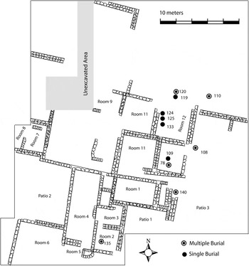
Excavations at Axotlan revealed two large residential compounds (Figure 3) as well as some poorly preserved stone architecture that may represent either a degraded compound or a cluster of less substantial structures. More than 2,000 such compounds were built at Teotihuacan during the Tlamimilolpa phase and housed most of the city's population from a.d. 200–650. These structures comprised multiple rooms, patios, courtyards, and passageways and were organized into several separate living quarters identified as apartments. Millon (Reference Millon1973) estimated that they housed up to 60 to 100 people at a given time, although they vary widely in size, quality, and internal arrangement. Many compounds and civic-ceremonial structures at Teotihuacan share an orientation of 15 degrees east of north (Drewitt Reference Drewitt, Tapia and Rattray1987; but see also Widmer and Storey Reference Widmer, Storey, Santley and Hirth1993). This is true of Axotlan's compounds as well.
Plan of Tlamimilolpa phase compound excavated in Frente 1, Axotlan (after García Chávez et al. Reference García Chávez, Cabezas and Vélez Saldaña2004).

Cerro Portezuelo
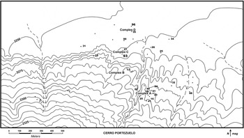
Cerro Portezuelo is located about 40 km south of Teotihuacan, on the southern edge of the Texcoco region, in the municipio Chimalhuacan. In 1954 and 1955 George Brainerd excavated more than 60 test pits at the site (Branstetter-Hardesty Reference Branstetter-Hardesty1978:2; Hicks Reference Hicks2013). Following Brainerd's untimely death, Henry B. Nicholson and Frederic Hicks continued field investigations into the 1960s. Brainerd's excavations consisted primarily of test pits geared toward chronological assessment but also included two trenches, Trenches 93 and 96 (Figure 4), which exposed public architecture. A series of platform structures uncovered in Trench 93 were dated to the Teotihuacan period.
Excavation units and architectural complexes at Cerro Portezuelo.

Extensive survey by Parsons (Reference Parsons1971) revealed that the Texcoco area was sparsely settled when Teotihuacan was at its height, having undergone a dramatic population decrease concurrent with the rapid growth of the urban center. Although the local population—an estimated 400 to 1,200 people dispersed across 60 ha—was not substantial (Parsons Reference Parsons1971:66, 196), Cerro Portezuelo was the largest settlement in the southeastern basin during the Teotihuacan period.
Recognizing the importance of a regional perspective for understanding the political reach of Teotihuacan, researchers have grappled with the role that settlements such as Cerro Portezuelo played in the regional political economy (see, for example, Mayer-Oakes Reference Mayer-Oakes1960; Parsons Reference Parsons1971; Sanders Reference Sanders1961). Parsons (Reference Parsons1971:197–198) suggested, based on the sharply declining population in Texcoco during the growth of Teotihuacan, that the southeastern basin was populated by small concentrations of people engaged in various specialized, exploitative activities tied to Teotihuacan's economic networks. Cerro Portezuelo was tentatively viewed as a small administrative center that coordinated local production and the delivery to Teotihuacan of raw materials and staple goods (Parsons Reference Parsons1971:198).
Parsons stressed that this hypothetical characterization of Cerro Portezuelo's relationship with Teotihuacan was amenable to testing, and the issue has been a focus of recent work on materials from the site. Based on analyses of the ceramics, architecture, and ritual deposits, Teotihuacan's direct involvement with Cerro Portezuelo appears to have been very limited. Although Cerro Portezuelo was politically subordinate to Teotihuacan, there is little evidence of intensive exchange with, or economic dependence upon, the capital. Significantly, Cerro Portezuelo maintained exchange ties with settlements other than Teotihuacan, suggesting that administration of the area may have been indirect. In particular, Cerro Portezuelo frequently acquired ceramic vessels produced in the west-central Basin of Mexico. Although regional exchange networks were likely shaped by the demands and desires of the Teotihuacan state and its urban population, this pattern suggests that they did not invariably operate under its thumb.
ENVIRONMENT, RESOURCES, AND STRATEGIES
The Basin of Mexico is characterized by considerable ecological diversity, owing to its topographical configurations and consequent variation in elevation, temperature, humidity, water sources, rainfall levels, and soil depth and fertility. Although the distribution of natural resources did not wholly determine the course of social history in the basin, every member of its population was reliant, directly or indirectly, upon these resources. To sustain the core population, administrative elites likely exercised various strategies for securing a steady supply of goods produced within the Teotihuacan Valley and in the wider Basin of Mexico hinterland. Teotihuacan's population required nutrient-rich crops such as maguey (Parsons Reference Parsons, Staller and Carrasco2010), grains, animal products, salt, cloth, pottery, lumber, and chipped and ground stone tools, among many other things (see Sanders et al. [1979:127] for a detailed list). Relationships between Teotihuacan and subordinate regional settlements were probably structured largely on the basis of strategies developed for acquiring these goods and resources.
Some settlements may have been important administrative nodes for organizing the flow of goods into Teotihuacan and to other rural areas that depended on such networks for their own provisioning. Settlements in key areas, such as those with highly productive agricultural land, may have been directly managed by the state. This sort of control could have been achieved by installing political administrators into existing communities, co-opting local elites, or establishing strategic settlements in previously unoccupied areas. Teotihuacan's ruling elites may have concurrently implemented all three of these strategies for securing regional control through the use of various administrative nodes. Settlements outside of key areas were perhaps less tightly linked to Teotihuacan except through periodic obligations, such as tribute in local products, labor, or military service. A comprehensive treatment of resource use and distribution is beyond the scope of this paper and has been discussed at length elsewhere by Sanders et al. (Reference Sanders, Parsons and Santley1979), Sanders and Santley (Reference Sanders, Santley, Vogt and Leventhal1983), and more recently by Parsons (Reference Parsons, Staller and Carrasco2010). However, it is important to consider how environmental settings and local resources associated with Axotlan and Cerro Portezuelo may have shaped their relations with Teotihuacan.
Axotlan and the Cuauhtitlan Region
Axotlan is located in the lower piedmont of the Cuauhtitlan region, which comprises 275 km2 and was surveyed in 1974 by Sanders and several colleagues (Sanders and Gorenflo Reference Sanders and Gorenflo2007:vi). The area is delimited by the Tepotzotlan mountain range in the northwest and the Guadalupe range in the southeast, each of which is an extension of the Sierra de Las Cruces. The shorelines of the brackish lakes Xaltocan, Zumpango, and Texcoco framed the eastern edge. The Río Tepotzotlan and Río Cuauhtitlan transected the Cuauhtitlan valley, carrying water from the mountains toward the basin's central lake system (Nichols Reference Nichols1980; Sanders and Gorenflo Reference Sanders and Gorenflo2007:5). The settlement of Axotlan was located between these two rivers, to the immediate south of the Río Tepotzotlan (Sanders and Gorenflo Reference Sanders and Gorenflo2007:257, 259).
The Tepotzotlan and Cuauhtitlan rivers would have provided permanent sources of water for Cuauhtitlan residents and farmers, which contributed substantially to the agricultural productivity of the area. Nichols (Reference Nichols1980:82–85) demonstrated that permanent irrigation in the Cuauhtitlan valley could cover an area at least equal to that irrigated by the permanent system at Teotihuacan. Sanders and Santley (Reference Sanders, Santley, Vogt and Leventhal1983:262) estimated that the Río Cuauhtitlan provided 10,000 to 15,000 people in a cluster of large settlements with water for irrigation during the Teotihuacan period. More comprehensive treatments of the geology, topography, precipitation, and hydrology of the Cuauhtitlan region are provided by Nichols (Reference Nichols1980) and Sanders and Gorenflo (Reference Sanders and Gorenflo2007).
Sanders et al. (Reference Sanders, Parsons and Santley1979:122) defined four settlement zones in the Basin of Mexico, each related to a different kind of resource use, with the Cuauhtitlan region as one of several areas in Zone 2. This area and Zone 1 (the Teotihuacan Valley, Patlachique Range, and northern Texcoco) were hypothesized to have provided most of the staple goods necessary for supporting the urban population. Ethnohistoric evidence and settlement data from the Cuauhtitlan region suggests that it was a highly productive agricultural area during all phases of occupation. The Codex Mendoza lists the yearly tribute to Aztec Tenochtitlan from Cuauhtitlan as about 200 tons each of maize, chia, beans, and amaranth (Borah and Cook Reference Borah and Cook1963:59). Sanders and Gorenflo (Reference Sanders and Gorenflo2007:291) suggest that Cuauhtitlan's high agricultural productivity supported large villages in the region during the Teotihuacan period. This settlement pattern differed from other parts of the basin, where populations tended to be dispersed across small hamlets that dotted the rural landscape.
Beyond agricultural goods, marsh fowl and other lacustrine resources may have factored in the Cuauhtitlan regional economy, along with salt harvested from the lakes. In addition, Cuauhtitlan was a major pottery producer from at least the Late Postclassic period (a.d. 1350–1521) through the eighteenth century (Gibson Reference Gibson1964:350–351). If land and resource use in the Cuauhtitlan region was similar during the Teotihuacan period, it would have been a strategic area for exploitation. Axotlan is postulated here to have been a key regional settlement that was directly administered, politically and economically, by the Teotihuacan state.
Cerro Portezuelo and the Texcoco Region
The Texcoco region comprises four environmental zones that differ as a function of increasing elevation as one travels eastward from the lakeshore to the Sierra Madre Oriental (Parsons Reference Parsons1971:3). These include the lakeshore plain (2,240 to 2,275 m asl), lower piedmont (2,275 to 2,500 m asl), upper piedmont (2,500 to 2,750 m asl), and high sierra (2,750 to 4,000 m asl). Cerro Portezuelo is located at the edge of the lower piedmont. Its inhabitants could exploit resources associated with the lakeshore plain and practice terrace agriculture on the lower piedmont slopes. Sanders et al. (Reference Sanders, Parsons and Santley1979:127) suggested that sites in southern Texcoco provided mostly lacustrine resources to Teotihuacan, such as fish, waterfowl, reed fibers, and wild plants.
Maize, beans, and squash can be grown in Texcoco from May to early October (Parsons Reference Parsons1971:7). Throughout the Basin of Mexico these crops are threatened by killing frosts that occur from November through at least January, and often into March. The threat of frost is more severe on the lakeshore plain than in the lower piedmont (Sanders et al. Reference Sanders, Parsons and Santley1979:86). Perhaps not surprisingly, the vast majority of settlements during the Teotihuacan period in the Texcoco region were located in the lower piedmont (Parsons Reference Parsons1971). The area is also well-suited to maguey cultivation. Maguey is currently grown on the terraced slopes of this area and probably figured prominently in the subsistence economy of this and other subregions of the Basin of Mexico, including the Teotihuacan Valley itself. These plants were a significant source of fiber for clothing and rope; food from leaves, hearts, and sap; alcohol in the form of pulque; and fuel from dried stumps. Parsons (Reference Parsons, Staller and Carrasco2010:117) notes that maguey can be grown even in marginal tierra fría contexts and that it supplies as many calories per hectare as seed crops such as maize, potentially doubling productivity where the two crops are grown together.
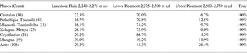
Table 1 provides settlement distribution data in terms of the proportion of sites in each environmental zone through time and shows that the lakeshore plain was sparsely settled, compared to the lower piedmont, until the Early Postclassic period (a.d. 850–1150). Increased use of the lakeshore plain from the Postclassic period onward was associated with growing population density and the development of chinampa farming (Parsons Reference Parsons1971:182, 220), a form of intensification that improved seed crop productivity significantly (Parsons Reference Parsons, Staller and Carrasco2010:117).
Distribution of sites in the Texcoco region among three ecological zones through time, based on settlement data published by Parsons (Reference Parsons1971)

The agricultural situation in Texcoco during the Teotihuacan period probably posed no major difficulties for the relatively small local population, which Sanders et al. (Reference Sanders, Parsons and Santley1979) estimated to have been about 4,850 people. However, the area was perhaps not a high priority for state-level exploitation, especially if there were other parts of the basin viewed as more productive, efficient, or manageable. Areas such as the Cuauhtitlan region and the west-central basin, where Azcapotzalco was located, may have satisfied these criteria. Azcapotzalco was the second largest center (after Teotihuacan) in the basin during the Teotihuacan period and was located on a large expanse of irrigable alluvial plain (Parsons Reference Parsons1971:194). Cerro Portezuelo was probably not a major supplier of staple foods to Teotihuacan, although its inhabitants may have paid some other form of tribute.
THE SOCIOPOLITICAL IMPLICATIONS OF ARCHITECTURE
Residential Patterns at Axotlan and Cerro Portezuelo
The use of apartment compounds to house large groups of people at Axotlan lends a distinctively urban character to the settlement and readily expresses cultural semblance with the urban population of Teotihuacan. Analysis of nonmetric dental morphological traits (Novotny and Clayton Reference Novotny and Clayton2007) indicates that Axotlan's compounds were probably occupied by extended kin groups, as Spence (Reference Spence1974) proposed for Teotihuacan. Compounds at Axotlan differed from each other in size, internal design, and quality of construction, echoing the variability present among Teotihuacan's compounds. García Chávez et al. (Reference García Chávez, Cabezas, Vélez Saldaña, Gallut and Peralta2005) cite the marked variability of construction quality among Axotlan's residential structures as strong evidence for status differentiation. The distance between high and low status households at Axotlan was probably not as wide as at Teotihuacan, as the former had a much smaller population. Axotlan is unlikely to have hosted the highest echelons of society that resided at the urban center, but it is possible that its local households were integrated into the same class structure that operated in the urban context.
The fact that Axotlan was settled and that its apartment compounds were built at the height of Teotihuacan's statehood is consistent with the view that it was founded as part of a program of rural resettlement (García Chávez et al. Reference García Chávez, Cabezas, Vélez Saldaña, Gallut and Peralta2005). Such a program likely involved the strategic acquisition by the state of agricultural resources through direct political administration. The use of apartment compounds at Axotlan may primarily reflect a close association with Teotihuacan rather than a practical need to house a growing population. The construction of compounds would have allowed for an urban pattern of living that easily accommodated domestic configurations similar to those in the city. It may also have facilitated political administration of the Axotlan settlement by enhancing what Scott (Reference Scott1998) has described as legibility. That is, recognizable residential forms would have made it easier for state officials, such as tax collectors, to navigate communities that they were not a part of. As a distinctive architectural style, apartment compounds would also have effectively communicated a recognizable social relationship with the Teotihuacan state. This relationship was one of political subordination, but probably also entailed a range of benefits associated with belonging to, and identifying with, Teotihuacan society.
Unlike Axotlan, the nature of residential architecture at Cerro Portezuelo is unknown since extensive excavations of Teotihuacan-period architecture there focused only on the group of ceremonial platform structures in Trench 93. It is tempting to suspect that apartment compounds were absent at Cerro Portezuelo. It seems likely that architecture this substantial would have been identified during survey (Parsons Reference Parsons1971) or test pit excavations (Hicks Reference Hicks2005). Sanders et al. (Reference Sanders, Parsons and Santley1979:126) noted that the heavy rock rubble suggestive of compound architecture at central basin sites is conspicuously lacking in the southern Texcoco region. However, data from excavations at Cerro Portezuelo during the 1950s (Hicks Reference Hicks2013) are insufficient for putting this question to rest. It is possible that compound architecture is not well preserved at Cerro Portezuelo, is obscured by later settlement, or has simply not yet been discovered. The lack of evidence for compounds, however, does suggest that residents of Cerro Portezuelo may have lived in structures that left a less conspicuous trace on the landscape. Residential structures that were less substantial and less permanent than apartment compounds are known to have existed within Teotihuacan itself and especially in its immediate outer margins (Cabrera Cortés Reference Cabrera Cortés2011; Robertson Reference Robertson2008).
In contrast to the north, the southern basin hosted a large population during the Patlachique and Tzacualli phases (150 b.c. to a.d. 125), which Sanders and Santley (Reference Sanders, Santley, Vogt and Leventhal1983:264; see also Sanders et al. Reference Sanders, Parsons and Santley1979) estimated to have been around 80,000 to 100,000 people. This decreased dramatically to an estimated 25,000 during the subsequent phases of Teotihuacan's statehood. The ceramic evidence at Cerro Portezuelo indicates a small Patlachique phase occupation, which continued into the early Teotihuacan-period phases (Tzacualli through Tlamimilolpa). Perhaps this population represented a group of people that elected not to join in the influx to Teotihuacan during the early part of its history.
The ceramic typology for Teotihuacan is still being developed, and the lack of detailed stratigraphic data from the 1950s excavations complicates the phasing of Teotihuacan-period ceramics at Cerro Portezuelo. Several sherds from Cerro Portezuelo were necessarily categorized broadly as Teotihuacan period rather than assigned to specific phases. Of 570 sherds assigned to specific Teotihuacan phases, however, 26% represent the Tzacualli and Miccaotli phases, 72% represent the Tlamimilolpa phase, and only 2% were phased to Xolalpan or later.
Further excavations are necessary for determining whether apartment compounds were built at Cerro Portezuelo, which is a challenge given that the site is largely buried under modern development. Nonetheless, determining whether compounds were present is important for reconstructing local socioeconomic organization as well as the nature of interaction with Teotihuacan. Residential organization at Cerro Portezuelo during the Teotihuacan-period may reflect a continuation of the pre-Teotihuacan pattern. Given the relative paucity of Xolalpan-phase ceramics at the site, it is possible that the area was largely abandoned or had a very small local population at the time when compounds became the primary mode of living within the capital. An absence of compounds may also indicate that local residential organization differed significantly from that of Teotihuacan. Economic production, including farming and craft activities, may have been organized primarily at the household level rather than the suprahousehold level. The presence of apartment compounds, on the other hand, would indicate that Cerro Portezuelo's residents identified with, and shared fundamental aspects of, social organization with the urban population.
Ceremonial Architecture and Ritual Practices
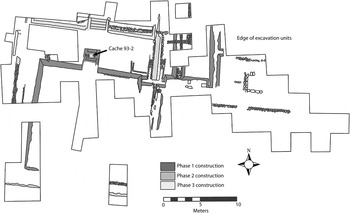
An important architectural distinction between Cerro Portezuelo and Axotlan is the presence at the former of a group of prominent civic-ceremonial platform structures that were detached from residential structures. These structures likely functioned as public, or at least highly visible, ceremonial spaces. Ceremonial architecture of this sort has not been observed at Axotlan, where ritual activities were perhaps conducted primarily in residential spaces. Most of the Teotihuacan-period material from Cerro Portezuelo was recovered from the platform structures in Trench 93, collectively called “Ceremonial Complex C” (Figure 5). These structures were modified several times and were the probable settings of suprahousehold activities. Public gathering of a social, religious, or political nature would have structured and reinforced local leadership institutions as well as cooperative ties and obligations among households in the area.
Trench 93 showing location of Cache 93-2 (modified from original drawing by Frederic Hicks).

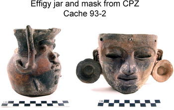
Complex C included a platform that was enlarged in its second construction phase (Structure C-I-2nd) to approximately 22 × 18 m, during which time it exhibited talud tablero style architecture as well as a mural painting (Hicks Reference Hicks2013). These features are often associated with Teotihuacan architecture. This second building phase began with a fairly elaborate dedicatory burial, Cache 93-2. At least one and possibly two individuals were placed directly on the centerline stairway of the Phase I structure and subsequently buried. The individuals appear to have been bundled and were buried with 24 ceramic vessels. The offerings also include a small effigy jar with “Storm God” features and two funerary masks, one of which was complete (Figure 6). The mold-made clay masks resemble masks from Teotihuacan, except that they are slightly larger than most Teotihuacan examples. Cache 93-2 is the richest burial known from Cerro Portezuelo, located within the largest known Teotihuacan-period ceremonial structure at the site. The individuals inhumed in this context must been important members of their community. Might they have been Teotihuacan officials installed to administer the local population? Alternatively, were they local leaders or ancestors who were not strongly linked to Teotihuacan?
Ritual objects from Cache 93-2, Cerro Portezuelo.

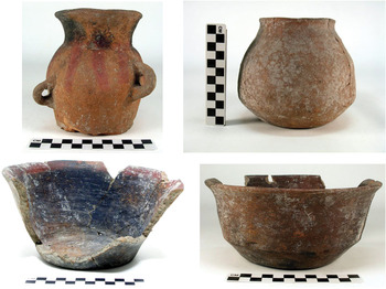
The ceramic vessels in Cache 93-2, some of which are shown in Figure 7, are low in quality compared to those found in high status burials in civic and domestic contexts at Teotihuacan. Although some of the vessels bear slight resemblance to ceramics from Teotihuacan, on the whole they are not stylistically reminiscent of pottery from the city. For instance, the effigy jar seems to depict the “Storm God” but does not closely resemble such jars from Teotihuacan, which typically have taller necks, larger ear spools, and more stylized and standardized facial features. The example from Cerro Portezuelo, in contrast, has a relatively naturalistic nose and mouth, full cheeks, and a more globular body. The stylistic attributes of the vessels from Cache 93-2 do not point to Teotihuacan as a production source. They are, therefore, consistent with the hypothesis that the individuals in this context were local elites buried with offerings representing local material culture.
Vessels from Cache 93-2, Cerro Portezuelo.

To explore this question further, samples of eight of the vessels and the mask were submitted to the Missouri University Research Reactor (MURR) for instrumental neutron activation analysis (INAA). Analyses of the cache vessels were conducted as part of a larger effort to determine the provenance of ceramics used by residents of Cerro Portezuelo throughout its occupation (Nichols et al. Reference Nichols, Neff and Cowgill2013). Hector Neff performed the statistical analyses necessary for assigning all ceramic specimens into compositional groups representing their probable origins within the basin. The INAA process as applied to materials from Cerro Portezuelo is outlined by Nichols and colleagues (2013; see also Bishop and Neff Reference Bishop, Neff and Allen1989; Bishop et al. Reference Bishop, Rands, Holley and Schiffer1982; Neff Reference Neff, Neff and Glowacki2002).
Results of INAA indicate that the Cache 93-2 vessels were produced in at least three different subregions of the Basin of Mexico. Of the eight vessels analyzed, three could be confidently attributed to specific compositional groups. Two of these were produced in the west-central basin, which was dominated by the secondary center of Azcapotzalco during the Teotihuacan period. The third artifact assigned to a compositional group was the mask. This was attributed to a production area in the southern basin (near Cerro Portezuelo), although the source of the mold from which it was made is unknown. Five specimens from Cache 93-2 remain “unassigned,” but in each of these cases the chemical evidence clearly favors one group over others (Nichols et al. Reference Nichols, Neff and Cowgill2013). As a result, each vessel was given a “probable” group assignment, which is tentative. Probable attributions include the Teotihuacan Valley and the west-central basin. Despite these probable attributions, no vessel from the cache was definitively attributable to Teotihuacan itself. The conclusion to be drawn is that the vessels were imported from a variety of sources. This pattern of pottery acquisition from the western basin and other subregions, which I further discuss below, is consistent with results of chemical analysis of ceramics from across the site.
Cerro Portezuelo had in common with Teotihuacan the use of some motifs and stylistic features (for example, the “Storm God” and talud tablero architecture). However, the presence of these symbols must not be mistaken for concrete evidence of emulation or direct participation in the political and religious institutions of Teotihuacan. Talud tablero architectural style and the “Storm God” motif did not originate at Teotihuacan; they appeared earlier at sites in the Puebla-Tlaxcala region (Blucher Reference Blucher1971; Carballo Reference Carballo2007; García Cook Reference García Cook, Sabloff and Sabloff1981). These and other symbols were likely co-opted and manipulated by Teotihuacan's elite class, their meanings transformed to undergird institutions of rulership (Carballo Reference Carballo2007). However, Cerro Portezuelo's use of these iconographic elements, which have historical roots outside of the Basin of Mexico, may reflect deeply-embedded cultural traditions that originated prior to the emergence of Teotihuacan as a state.
CERAMICS AND INTRAREGIONAL INTERACTION
As mentioned above, the ceramic data from Axotlan and Cerro Portezuelo were originally generated with differing objectives. Ceramic data from Axotlan result from a detailed attribute analysis of whole vessels from 76 Teotihuacan-period burials (Clayton Reference Clayton2009). In contrast, only four burials dated to the Teotihuacan period were excavated at Cerro Portezuelo (Caches 93-1, 93-2, 93-3, and 19 in Trench 93). Ceramics analyzed from this site were obtained from excavations representing a variety of depositional contexts. A sample of 238 ceramic specimens representing the Patlachique through Miccaotli phases (n = 45) and the Tlamimilolpa through Xolalpan phases (n = 193) was submitted for INAA.
Because discrete settlements (Axotlan and Cerro Portezuelo) represent the units of analysis in this study, I pursue this comparison of ceramic assemblages despite the differing contexts that the artifacts represent. The inferences presented here are tentative and are based on the data that are currently available. Variation in the questions of interest to different researchers often results in incongruent data sets, so synthetic analyses should be conducted with caution. Comparisons of data from different projects can, nonetheless, contribute to an improved understanding of the nature of intraregional relationships (Charlton Reference Charlton, Tapia and Rattray1987:474).
Some limitations of ceramic data for reconstructing regional social and economic interaction should be acknowledged. First, relationships between settlements cannot be understood purely through chemical compositional analysis, even when provenance can be securely determined. Compositional data do not indicate exactly how pots moved from one place to another or how many times a vessel was exchanged. In addition, ceramics are not the only kind of material that was exchanged. The transport of bulky and breakable pots is costly, and clay resources were widely available. Therefore, the orbits within which most ceramics circulated are likely to have been smaller, in general, than those of materials such as obsidian (Sanders and Santley Reference Sanders, Santley, Vogt and Leventhal1983:255). Despite these caveats, it is known that ceramics changed hands across the ancient Basin of Mexico. For example, Thin Orange Ware, produced in Puebla, was widely traded, despite high transportation costs, due to its particular aesthetic and functional qualities (Charlton Reference Charlton and Trombold1991; Rattray Reference Rattray2001). Many forms of exchange were probably operating, including reciprocation between households, trade with traveling merchants, and the purchase of pottery at urban and rural marketplaces.
Since ceramics circulated, the characterization of assemblages through compositional analysis is worth pursuing. Compositional data are valuable not only for reconstructing the flow of goods into and out of Teotihuacan, but also for considering exchange between rural settlements. The reconstruction of intraregional networks beyond those that intersected the city is crucial for understanding the degree to which economic centralization was a factor in Teotihuacan's regional power. It must be recognized, however, that the precise mechanisms for the exchange of goods were complex, dynamic, and probably varied a great deal. For example, ceramics might change hands several times in an economic system with markets, merchants, and middlemen. A vessel made in a Teotihuacan workshop could conceivably end up in a rural household quite indirectly, by way of economic interactions in the hinterland. Due to this complexity, the production source of vessels must be regarded as only one line of evidence from which inferences about the intensity, duration, and directness of ties between Teotihuacan and rural settlements might be made. Other important considerations include the content of rural ceramic assemblages (the range of vessel forms and their functions) as well as the stylistic qualities of the vessels and the degree to which they resemble similar forms from Teotihuacan. These lines of evidence collectively speak to the intensity and regularity of direct interaction between residents of the hinterland and those of the urban capital. They reflect not only the degree of economic integration, but also social affinity with the urban population and its institutions, a point I return to below.
I expect that rural settlements closely linked to Teotihuacan's economic networks would have more pottery from Teotihuacan than those that did not engage in regular, direct interaction with Teotihuacan. But this expectation is likely to be met in relative terms, due to the complexity of exchange in a state-level system. For example, even rural households that did not frequently interact with urban merchants or potters may have occasionally acquired vessels produced at Teotihuacan. Teotihuacan was a vibrant metropolis, and members of rural communities may have periodically traveled there to visit marketplaces or participate in political or religious events. Therefore, some objects may have been obtained from the city even if this was neither a part of regular economic activities nor optimally cost-effective (see Sanders and Santley Reference Sanders, Santley, Vogt and Leventhal1983:255). Furthermore, some vessels acquired from rural marketplaces might have originally been made at Teotihuacan. For these reasons, compositional data must always be examined alongside other lines of evidence, including stylistic attributes and assemblage content, in order to understand regional exchange relationships.
With respect to assemblage content, I expect that rural households with close social ties to Teotihuacan would have ceramic assemblages similar to those of urban households. Such material similarities would result not just from exchange, but from the perpetuation of socially identifying behaviors. Practices associated with domestic ritual and cuisine would have identified rural households as belonging to Teotihuacan society and subscribing to shared beliefs. In addition, pottery at settlements closely linked to Teotihuacan's urban population should be stylistically similar to pottery used in urban households. That is, rural potters in regular contact with Teotihuacan potters or their products would know the typical proportions and decorative features of vessel forms characteristic of Teotihuacan material culture. They would be able, in most cases, to execute these stylistic attributes in a way that was similar to Teotihuacan potters. The “Storm God” jar from Cerro Portezuelo discussed above does not meet this expectation of stylistic likeness.
I discuss the results of compositional and stylistic analysis of ceramics from each site in detail below but briefly introduce the patterns here. Axotlan and Cerro Portezuelo exhibit considerable differences in their ceramic assemblages. Both sites have some ceramics that are “Teotihuacan-style,” as well as some objects that were made at Teotihuacan. However, the clear stylistic congruity and assemblage uniformity expected to result from frequent and direct economic and close social affinity with urban social groups is observable only at Axotlan. The general ceramic assemblage at Cerro Portezuelo differs markedly from that of Teotihuacan in the vessel types it includes and their stylistic attributes. Nonetheless, a considerable portion (12.4%) of the sample of Teotihuacan-period ceramics from Cerro Portezuelo submitted for INAA was determined to have come from the Teotihuacan Valley. An unanticipated finding, however, is that Cerro Portezuelo's residents acquired objects from other settlements in the hinterland at least as frequently as from Teotihuacan. Specifically, 12.4% of Teotihuacan-period specimens are attributed to the west-central Basin of Mexico.
Axotlan Ceramics
Most ceramics from Axotlan burials would not be considered out of place in burials at Teotihuacan. This pattern may reflect an economic relationship as well as social and ideological identification with the urban population. The full range of Teotihuacan forms and wares representing the Tlamimilolpa and Xolalpan phases is present at Axotlan, including Thin Orange, San Martín Orange, Matte, Polished, and Painted Wares (see Rattray Reference Rattray2001). Axotlan's residents probably acquired some pottery directly from Teotihuacan marketplaces or merchants. For example, heavy San Martín Orange craters, for which specific production areas have been identified at Teotihuacan (Sullivan Reference Sullivan2006), are present at Axotlan. Residents of this settlement may also have been making imitations of pottery circulated at Teotihuacan. For example, Axotlan's burials often included vessels that closely resemble Thin Orange Ware hemispherical bowls but were likely produced using clay sources that were closer to home (Clayton Reference Clayton2009). Thin Orange imitations have also been observed at Teotihuacan itself, and it is possible that these vessels in the Axotlan assemblage were also acquired from the city.
Compositional studies of pottery at Axotlan have not been undertaken and pottery production at the site itself has not been confirmed, although some pottery was certainly manufactured in the Cuauhtitlan region. The question of whether Axotlan also acquired vessels from production centers other than Teotihuacan could be addressed using INAA in the future.
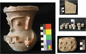
Residents of Axotlan used objects frequently associated with domestic ritual at Teotihuacan, such as unfired clay miniatures, “Storm God” effigy jars, composite censers, and candeleros (Figure 8). Such objects bear an unmistakable resemblance to Teotihuacan material culture and are absent or rare in the Cerro Portezuelo sample. The “Storm God” jars from the two rural sites are strikingly different, and the example from Axotlan so closely resembles Teotihuacan examples that it could easily have come from an urban workshop.
Objects from ritual contexts at Axotlan: “Storm God” jar, censer adorno, miniature jars, and candelero.

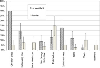
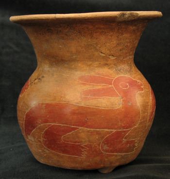
Figure 9 illustrates a comparison between the burial assemblage of Axotlan and that of a Teotihuacan residential area called La Ventilla, excavated between 1992 and 1994 as part of the Proyecto La Ventilla (Gómez Chávez Reference Gómez Chávez2000). The sample of burials used in this comparison comes from excavations in Frente 3, identified as “La Ventilla 3.” Figure 9 shows the percent of inhumed adults (81 from Axotlan and 93 from La Ventilla 3) with whom nine categories of objects were associated. These include obsidian blades, outcurving bowls, jars (see example in Figure 10), vasitos (small painted cups), ollitas, cylindrical vases, Thin Orange hemispherical bowls, local hemispherical bowls, and tecomates. Residents of La Ventilla 3 and Axotlan used remarkably similar material accoutrements in the context of funerary ritual, with a few exceptions. First, local hemispherical bowls and tecomates are not present in this sample of burials from La Ventilla 3. There is also a notable difference in the proportion of individuals at each site buried with obsidian blades and cylindrical vases. Differences in the use of these particular objects may reflect sociospatial variation in the funerary practices that were meaningful to residents of distinctive communities.
Percent of adults at Axotlan and La Ventilla 3 buried in association with nine object categories. Bars indicate 95% confidence intervals.

Incised red on natural jar from Axotlan Burial 1, Frente 3.

In general, however, the presence of Teotihuacan-style materials in ritual contexts at Axotlan indicates that the particular activities and social roles with which these objects were associated were meaningful to the inhabitants of this settlement. Moreover, they were used in much the same way as they were at Teotihuacan, a point that I discuss further below. Such ritual congruity is strong evidence for shared beliefs and social affinity with the urban population. The degree of material similarity also suggests that many goods were acquired through participation in common economic networks.
Burial 135 from Frente 1 at Axotlan exemplifies mortuary practices that were primarily meaningful at a local level but also expressed ideological values espoused by residents of Teotihuacan. This was a cluster of five individuals, including three infants and two females at least 45 years of age, whose offerings suggest that they had particular ritual roles within their kin group or community. Among the objects recovered from this context were the remains of a purposefully disassembled composite censer (Figure 11). These censers, which were decorated with distinctive, standardized adorno attachments, are found in most Teotihuacan compounds (Cowgill Reference Cowgill1997:142) in low frequencies. That is, they are not “common” in Teotihuacan burials, but are often found in one or two burials per compound. Moreover, the practice of disassembling, perhaps ritually terminating, composite censers and placing the pieces within burial contexts has been demonstrated at Teotihuacan residential sites (Manzanilla Reference Manzanilla, Silverman and Small2002). The occurrence of composite censers in apartment compounds suggests they were primarily associated with domestic ritual. However, there is also strong evidence that they were linked with a state-sanctioned religious ideology (Cowgill Reference Cowgill1997:142). For one thing, they are not known to have originated prior to the Teotihuacan state, and they did not survive its collapse. Even more compelling is the discovery of a specialized workshop for the production of censers and adornos located in a large enclosure adjacent to the north side of the Ciudadela at Teotihuacan (Múnera Bermúdez Reference Múnera Bermúdez1985). Perhaps the women in Burial 135 at Axotlan held social positions that connected them to institutions of the state. The use of standardized ritual equipment within their burials suggests that they might even have migrated directly from the urban center to Axotlan. This hypothesis is further supported by the presence of a San Martín Orange Ware crater in the same burial.
Parts of a composite censer from Axotlan Burial 135, Frente 1.

Mortuary contexts at Axotlan reflect behaviors, beliefs, and social relationships that were salient within the local community and its constituent social groups. They were not necessarily emblematic expressions of social or ideological affiliation with the Teotihuacan state; rather, many ritual traditions are likely to have had a long regional history. For example, practices such as flexed body positioning are certainly not exclusive to Teotihuacan. However, these practices indicate that residents of Axotlan shared certain ritual-ideological notions with much of the urban population. Moreover, the presence of specialized ceremonial objects, such as composite censers and “Storm God” jars, in a few burials is important. This indicates that at least a subset of Axotlan's population identified closely with the ritual institutions of Teotihuacan.
Cerro Portezuelo Ceramics
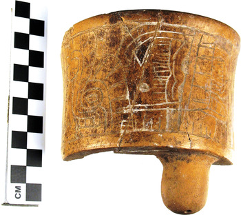
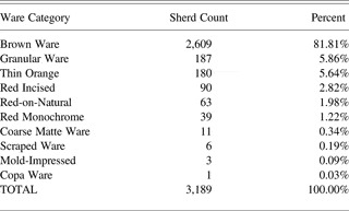
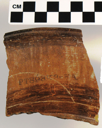
Sanders et al. (Reference Sanders, Parsons and Santley1979:125) reported having an impression that sites in the southern Texcoco region lacked the full range of ceramic forms and wares commonly found in Teotihuacan-period residential sites, and this is true of Cerro Portezuelo. Cylindrical vases, composite censers, San Martín Orange Ware, and several Coarse Matte Ware forms, such as candeleros, tapaplatos, and three-prong burners, are either absent or very rare. Thin Orange Ware, the distribution of which is argued to have been controlled by Teotihuacan (Rattray Reference Rattray2001) makes up 5.6% of Cerro Portezuelo sherds (Table 2). This is a relatively low proportion compared to Teotihuacan, where 15.4% of sherds from surface collections are Thin Orange Ware (Cowgill et al. Reference Cowgill, Altschul, Sload and Hietala1984). Other rural sites may have similarly low proportions, but this remains to be investigated. Objects representing the Xolalpan phase are infrequent at Cerro Portezuelo. The presence of conical figurines and some ceramics, such as a single Copa ware cylindrical vase (Figure 12), indicates that the site was occupied during this phase. It is likely that the population had diminished significantly, however. Objects representing the Metepec phase appear to be absent, suggesting a possible occupational hiatus at Cerro Portezuelo during the latest years of Teotihuacan's dominance.
Copa ware cylindrical vase found at Cerro Portezuelo, Xolalpan phase.

Counts and percents of ceramic wares at Cerro Portezuelo, based on stylistic analyses conducted at Arizona State University

The absence of several forms and wares characteristic of the Xolalpan and Metepec phases at Cerro Portezuelo suggests that the small local population did not regularly import or imitate them and perhaps had limited access to them. It is plausible that ceramics from Teotihuacan held little local social or economic value for rural households during these latest phases of the state's dominance. At this time, Teotihuacan's grip on the region was probably weakening. The apparent absence of objects associated with Teotihuacan domestic ritual suggests that household ritual at Cerro Portezuelo may have differed significantly from that of Teotihuacan. Residents of Cerro Portezuelo did use figurines (Montoya Reference Montoya2008) and censers, although the latter do not appear to have been the composite form known from Teotihuacan (and no standardized adornos have been located).
Along with differences in assemblage content, there are stylistic indications that most of the pottery at Cerro Portezuelo was made near the settlement and that local production techniques differed from those of urban workshops. Outcurving bowls, for example, were common at both Cerro Portezuelo and Teotihuacan, but examples from the two areas differ visibly in surface finish. Most outcurving bowls from Cerro Portezuelo are polished both vertically and horizontally on the exterior (Figure 13). At Teotihuacan, exterior polishing marks on outcurving bowls are almost invariably horizontal. The difference may be understood in terms of technological style (Sackett Reference Sackett1977). Particular actions in the chaine-opératoire (Dietler and Herbich Reference Dietler, Herbich and Stark1998) of pottery-making in the southern basin, which reflect behaviors learned in local contexts, were distinct from those of urban workshops.
Outcurving bowl from Cerro Portezuelo with vertical polishing streaks.

Compositional analysis indicates that some pottery consumed at Cerro Portezuelo was made in the Teotihuacan Valley, a pattern that is not unexpected, given Teotihuacan's size and its economic and political domination of the region.
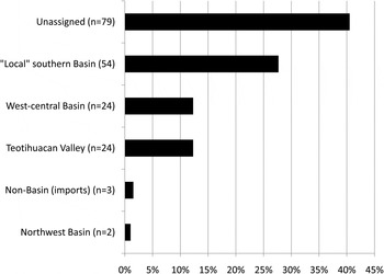
An unanticipated finding, however, is that an equally high proportion of Cerro Portezuelo's ceramic assemblage was made in the west-central basin. Figure 14 shows the distribution of Tlamimilolpa-Xolalpan phase INAA specimens from Cerro Portezuelo by source area. The majority of specimens for which provenance could be determined were from “local” sources in the southern basin. This category includes three distinct compositional groups: Chalco, SB-3, and SB-4 (Nichols et al. Reference Nichols, Neff and Cowgill2013), which may reflect separate subareas or workshops. It is important to note that many sherds in the sample were specifically selected for INAA based on their stylistic likeness with Teotihuacan pottery. Therefore, the percentage of specimens in the sample that originated in the Teotihuacan Valley is likely to be inflated.
Percentage of Tlamimilolpa-Xolalpan phase specimens from Cerro Portezuelo by source area.

Strong associations between specific ceramic types or forms and specific compositional groups do not stand out in the data: a variety of vessel forms evidently came from each of the sources represented. However, a few patterns bear mentioning. For example, heavy utilitarian vessels such as cazuelas (Rattray Reference Rattray2001) were more frequently produced near Cerro Portezuelo (36% of those analyzed) than acquired from elsewhere (12%). This pattern likely relates to the high cost of transporting bulky pottery. Similarly, none of the censers (n = 9) or ollas (n = 10) analyzed was attributable to the Teotihuacan Valley, although three of the latter came from the west-central basin. Lighter-weight serving vessels such as outcurving bowls, in contrast, were frequently obtained from beyond Cerro Portezuelo. Of 64 outcurving bowls analyzed, 20% were attributed to the Teotihuacan Valley, 13% to the west-central basin, and 20% to “local” (southeastern basin) compositional groups. Outcurving bowls with vertical polishing, which is not typical of Teotihuacan, were attributed to the local production groups and the west-central basin.
The fact that a high proportion of the ceramics originated in the western basin has significant implications for the economic structure of the region when Teotihuacan was at its height. Documentary sources indicate that Azcapotzalco was a major pottery production and distribution center during the Postclassic period (Gibson Reference Gibson1964:350–351). Recent compositional studies indicate that ceramic manufacturing began at Azcapotzalco by the Teotihuacan period (Ma Reference Ma2003). Rattray (Reference Rattray2001:381) suggests that sites near Azcapotzalco served as “collection, market, and shipping centers for Teotihuacan but also may have maintained some autonomy from Teotihuacan.”
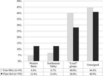
Figure 15 compares early (Tzacualli-Miccaotli [a.d. 1–200]) and late (Tlamimilolpa-Xolalpan [a.d. 200–550]) Teotihuacan-period ceramics from Cerro Portezuelo in terms of the percentage assigned to each of four major compositional groups. Most Tzacualli- and Miccaotli-phase pottery was attributed to “local” production sources near Cerro Portezuelo. However, it is clear that pottery was obtained from the western basin even during the early phases of Teotihuacan's political power. During subsequent phases, a higher proportion of the ceramic assemblage was imported from areas including the Teotihuacan Valley and the western basin. At this time, Teotihuacan likely had greater control over regional exchange networks, and the participation of rural communities in these networks would have meant access to a wide array of goods produced in the city, throughout the Basin of Mexico, and beyond. Of particular significance, though, is the fact that regional settlements were regularly exchanging goods with each other early in Teotihuacan's history. It is possible that these relationships were established prior to the rise of the state and continued to operate independently of direct state control during the Teotihuacan period. Notably, Cerro Portezuelo's ties with the western basin continued into the Epiclassic period (Crider Reference Crider2013), outlasting the political collapse of Teotihuacan.
Proportions of early and late Teotihuacan-period INAA specimens assigned to each of four major compositional groups.

DISCUSSION
Collectively, the architectural, ceramic, and mortuary data from Axotlan demonstrate its close relationship with the urban population of Teotihuacan. Residents of this settlement participated in direct exchange with urban potters or merchants and lived in apartment compounds like those of Teotihuacan. The use of specialized ceremonial objects in some burials suggests that residents of Axotlan shared ritual practices with the urban population that reinforced a similar social structure. The ecological setting of Axotlan, in the reliably-watered Cuauhtitlan region (McBride Reference McBride1974; Nichols Reference Nichols1980; Sanders and Gorenflo Reference Sanders and Gorenflo2007), probably factored in the decision to establish a community here. The need for salt and agricultural products may also have been key motivators in the exploitation of the Cuauhtitlan region. As newly established settlements, communities such as Axotlan may have been free of any complicated local histories with which the state would need to contend. Axotlan was, therefore, a strategic settlement with significant administrative utility for Teotihuacan's ruling elites. Significantly, the settlement was abandoned as the Teotihuacan state disintegrated, perhaps because it had ceased to function as an administrative node. The economic, political, and social ties between Axotlan's residents and the urban population likely began to break down during the Xolalpan phase, prompting significant shifts in social and residential organization.
Although Axotlan might be viewed as a rural extension of Teotihuacan society, some material distinctions between the rural settlement and the captial also speak to a unique local history. Over several generations, Axotlan's inhabitants engaged in activities and interactions that were locally meaningful and distinct from those of urban Teotihuacan. For example, burial practices associated with social groups at Teotihuacan were also practiced at Axotlan, reflecting ideological semblance with the urban capital. However, residents of Axotlan also made, acquired, and used objects in burials that were relevant within the context of their own domestic groups and communities (Clayton Reference Clayton2009).
The material culture of Cerro Portezuelo is strikingly different from that of Axotlan, attesting to the variation among Teotihuacan's rural contemporaries in the basin. The most conspicuous difference is the apparent paucity at Cerro Portezuelo of objects widely considered to be hallmarks of Teotihuacan domestic ritual.
The settlements compared here had differing relationships with Teotihuacan. Axotlan remains a strong candidate for an administrative node, while Cerro Portezuelo might have been only loosely integrated into Teotihuacan's political and economic networks. This is not to say that the latter was not subordinate to the state. On the contrary, by virtue of its proximity to the urban center and its small size, Cerro Portezuelo was well within the reach of Teotihuacan's power. However, the data that are currently available do not constitute robust evidence of direct local administration by elites associated with the capital or a close social affiliation with the urban population.
The reasons for Teotihuacan's differing involvement with Axotlan, Cerro Portezuelo, and other hinterland settlements, are likely multifaceted. From the perspective of statecraft, Teotihuacan perhaps did not prioritize control of the southern Texcoco region. Instead, state elites may have invested in the direct administration of areas served by permanent sources of fresh water or those where the cost to transport staple goods was lower. Although the sites compared here were both within 40 km of Teotihuacan as the bird flies, the route to the Cuauhtitlan was more efficient if canoe travel across Lake Xaltocan was utilized. Travelers from Teotihuacan to the southeastern basin, on the other hand, would have needed to cover more land, although travel by canoe would have been possible for part of the distance. The infrastructure for transport in the western basin may have been better-developed. It is not surprising that state elites would invest in the direct administration of key areas, since the management of hinterland settlements would have been costly.
Although the distribution of key resources is likely to have influenced administrative strategies, efforts to control some areas more tightly than others did not result purely from environmental circumstances. The dynamic histories of interaction, which may have been variably characterized by diplomacy or resistance, no doubt factored in the relative manageability of different settlements. Some rural communities may have engaged willingly with state institutions while others were reluctant, depending upon local social histories and economic patterns. Rural populations also identified socially with the urban population to differing degrees. The actions of agents situated in the hinterland were based on a range of perceived benefits and drawbacks presented by integration into the economic and political institutions associated with the state.
Results of this comparative investigation suggest that Teotihuacan developed consolidation strategies based on the shifting social, historical, and ecological conditions of different regions. Several New World empires have been compared in terms of regional administrative strategies (Berdan et al. Reference Berdan, Blanton, Boone, Hodge, Smith and Umberger1996; Conrad and Demarest Reference Conrad and Demarest1984; Ohnersorgen Reference Ohnersorgen2006; Schreiber Reference Schreiber1992; Stanish Reference Stanish1997). As an early urban, multiethnic state without regional precedent, Teotihuacan deserves a more prominent role in this dialogue. A growing body of data from the hinterland indicates that the state developed a variety of approaches to manage diverse rural populations and that rural communities exercised various strategies in response. Additional research at rural sites in the Basin of Mexico that is specifically geared toward understanding intraregional dynamics is also critical for understanding the developmental trajectory and sociopolitical makeup of this early urban society.
RESUMEN
La ciudad de Teotihuacan ha sido considerada como el principal centro (ciudad-estado) que dominó política y económicamente los asentamientos circunvecinos de la Cuenca de México. Sin embargo, sus relaciones particulares con los asentamientos subordinados aún no se comprenden del todo. En este artículo se presenta un análisis comparativo acerca de las relaciones económicas y políticas de Teotihuacan con dos distintos asentamientos de la Cuenca de México. Específicamente, se examinan las diferencias en la arquitectura y la cerámica entre los sitios de Axotlan, ubicado al oeste, y de Cerro Portezuelo, ubicado al sur. Los resultados de esta investigación demuestran que las relaciones de Teotihuacan con los asentamientos pequeños de la cuenca varían considerablemente tanto en intensidad como a lo largo del tiempo. Estas variaciones reflejan las estrategias administrativas particulares del Estado teotihuacano. Mientras que algunos asentamientos de la cuenca estaban fuertemente integrados al estado, otros ejercían un alto grado de autonomía política y económica.
ACKNOWLEDGMENTS
This research was supported by National Science Foundation Grant Nos. 0514187 (Deborah Nichols, Principal Investigator, Dartmouth College), 0513979 (George Cowgill, Principal Investigator, Arizona State University), and 0504015 (Missouri University Research Reactor). Additional support was provided by the Claire Garber Goodman Fund and the Rockefeller Center Urban Studies Grant at Dartmouth College and the School of Human Evolution and Social Change at Arizona State University. I am grateful to George Cowgill and Deborah Nichols for the opportunity to study materials from Cerro Portezuelo and for their valuable insight over the course of this project. I thank Hector Neff, who determined the probable sources of ceramic specimens submitted for INAA. I thank Alanna Ossa for her help in preparing specimens for compositional analysis and Destiny Crider for her collaboration on the analysis of Cerro Portezuelo ceramics. Analysis of materials from Axotlan was supported by a grant from the Foundation for the Advancement of Mesoamerican Studies. I express my gratitude to Raúl García Chávez, who graciously shared materials and data from Axotlan, to Anna Novotny, who analyzed the human remains, and to Guillermo García Román, who assisted with the ceramic analysis. This paper benefited considerably from comments offered by Leonardo López Luján, Jeffrey Parsons, Ian Robertson, Michael E. Smith, and one anonymous reviewer. All errors are entirely my own.