

INTRODUCTION
Museum artefact collections and archives can offer new and sometimes unexpected sources of information about archaeological sites that have long since passed from collective memory. Not only can this improve knowledge by adding to the known distribution of sites, but, very occasionally, it can provide valuable insights into human behaviour, even when the original context of the finds no longer survives. Reconstructing the topographic location of such discoveries from written sources can also help to identify opportunities for further field investigation and inform the planning process with regard to areas of high archaeological potential. This is nowhere more apparent than in relation to the mapping of Palaeolithic sites and Quaternary deposits, which remain generally under-represented in Historic Environmental Records (HERs).Footnote 1
In this paper we report on hitherto unpublished finds from Salisbury Museum that only came to light by chance during a project to mark the 800th anniversary of the medieval city and cathedral. In 2019 Wessex Archaeology embarked on a project to examine the story and development of Salisbury using material that was derived predominantly from archaeological sources.Footnote 2 This approach included information sourced from excavations related to the medieval city, but also evidence documenting human activity before the cathedral was constructed.
A search of available data revealed a largely forgotten collection of worked flints, listed as ‘Neolithic flakes’ at Salisbury Museum, that were found at Churchfields in Fisherton parish. The collection had been catalogued by the late Roger Jacobi, FSA. Information taken from his card index, and included on the Palaeolithic and Mesolithic Lithic Artefact database, records that he identified seven blades displaying characteristics of Late Upper Palaeolithic Long Blade (Terminal Upper Palaeolithic) technology with a further forty-five pieces of uncertain or Mesolithic date; no further details or references were made to specific items.Footnote 3 The Late Upper Palaeolithic, spanning the period between 13,000 and 10,000 radiocarbon years bp, is known from only two locations in the River Avon valley: Hengistbury Head, in Dorset, and Nea Farm, at Somerley in Hampshire.Footnote 4 This collection therefore forms a potentially important and apparently overlooked addition to the corpus of material from the period as well as a valued supplement to the story of Salisbury.
The collection that was examined comprises thirty-eight artefacts of which three groups carry distinctive labels. The largest group contains sixteen artefacts, all referenced ‘Churchfields 1860’, while seven items form a separate group and are inscribed ‘Churchfield’ with additional suffixes ‘a–d’, which suggests that they may have formed part of an itemised catalogue or featured in an exhibition.Footnote 5 This group also includes a blade of probable Greensand chert and an artefact with an attached label marked ‘Deposited by Dr Blackmore’. Eight further distinctive pieces are marked ‘Churchfield(s)’ and include a retouched blade, which most closely resembles a Neolithic fabricator and may therefore be intrusive. The entire collection is completed by five miscellaneous objects, which also relate to Churchfields and are labelled ‘Fisherton CF’ or ‘Fish CF’, with a blade marked ‘Fisherton’ and a snapped end scraper on a blade from ‘Fisherton b’, which was also ‘Deposited by Dr Blackmore’.
This undoubtedly refers to Dr Humphrey Purnell Blackmore (1836–1929) who studied medicine at St Andrew’s University and St Bartholomew’s Hospital, London, before qualifying in 1855.Footnote 6 He returned to Salisbury in 1856, where he established his name as one of the foremost medical practitioners in the city, taking up a position as surgeon at Salisbury Infirmary in 1856 and also being appointed as physician to the Fisherton Lunatic Asylum. Outside of medicine, Blackmore, together with other members of the family, including his brother, William, embraced all aspects of scientific study, contributing to archaeology, geology and zoology. Humphrey acquired an impressive collection of artefacts, including flint implements, some of which were displayed in a ‘Temporary Museum’ that was set up in Salisbury in January 1862. He subsequently became a trustee of the Salisbury and South Wilts Museum, which was founded by Dr Richard Fowler in 1860. Notebooks compiled by William, which are held in Salisbury Museum, do not mention the discovery of the blades; however, the archive illustrates that William was actively collecting in the Fisherton area in the late 1850s into the 1860s. It appears that his collecting preferences were directed, at the time, towards Pleistocene faunal remains that were being recovered from the local brick pits.
Thus, there seems to be no reason to doubt that the collection originated from the Churchfields area of Fisherton and that it was recovered at an embryonic point in the study of archaeology at Salisbury. However, the variable nature of the labelling makes it likely that the artefacts may not have been found at the same time and could therefore have been derived from different points within Churchfields.
THE SITE
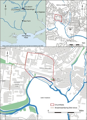
Churchfields lies on the west side of Salisbury in the parish of Fisherton. The area is now better known as the location of the Churchfields Industrial Estate, although in 1860, when some of these artefacts were apparently discovered, the area was markedly different.Footnote 7 The Parliamentary Enclosure of 1798 retained approximately thirty-two acres (12.9ha) as glebe land, listed as Churchfields, which extended north from the site of the former St Clement’s Church to Wilton Road.Footnote 8 This spur of land forms part of a low terrace, at approximately 50m od, bordering the floodplain of the River Nadder near its confluence with the River Avon to the east (fig 1). The boundary on the west side comprises the Spring Ditch, which drains from an active spring and Broad Mead/Spring Ditch Drove. The southern extent is marked by a river cliff that overlooks a meander of the River Nadder.
Site location shown relative to River Avon valley and with Salisbury. Church Field boundary taken from Parliamentary Enclosure 1798. Drawing: Kenneth Lymer, FSA.

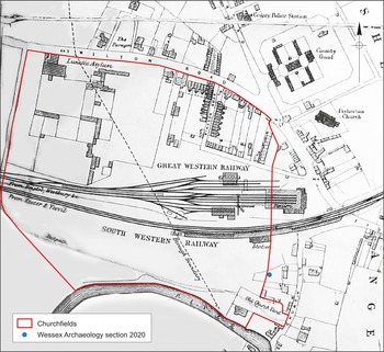
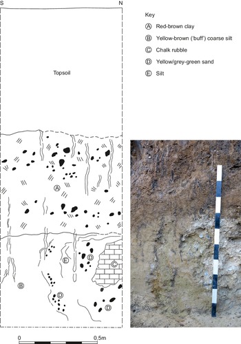
The area in which the flints are likely to have been found is mapped as river terrace deposits, which form part of the Fisherton Terrace at the southern fringes of the Fisherton brick fields.Footnote 9 Green et al observed sections in 1974, when the site of the former County Gaol was redeveloped, describing layers of red-brown soliflucted clay, which sealed deposits of buff coloured silty clay and grey-green sand.Footnote 10 These fine-grained deposits were found on or, as isolated pockets, within the fluvial terrace gravel. Similar deposits, which were covered by 0.85m of dark grey topsoil, have subsequently been recorded by Wessex Archaeology at the south edge of the terrace (fig 2). These deposits have confirmed the sequence whereby red-brown clay overlay a bed of fine yellow-brown, buff, coarse silt, which was probably uneconomical for brick-earth extraction (fig 3). This material also incorporates pockets of chalky rubble mixed with yellow, grey-green sand and silt, which suggest periglacial activity incorporating material from the underlying terrace deposits. The apparent inclusion of green sand is undoubtedly derived from Greensand bedrock (Lower Cretaceous) in the Vale of Wardour, through which the River Nadder flows.
Church Field showing location of Wessex Archaeology section 2020 and extent of development from mapping produced by Board of Health 1860 (© Wiltshire and Swindon History Centre, reproduced with permission). Drawing: Kenneth Lymer, FSA.

Section drawing and photograph of ‘brick-earth’ deposits on east edge of Churchfields. Drawing: Kenneth Lymer, FSA.

The land remained largely unmodified in area into the 1850s, when the northern part of Churchfields was incorporated into the Fisherton brickfield before being developed for residential use by 1860.Footnote 11 The central zone was transformed by the arrival of the Great Western Railway terminus in 1856, which was joined in 1859 by the London and South Western Railway. It may be no coincidence that William Blackmore became a director of the Salisbury Railway Company in 1857.Footnote 12 Such joint interests may have provided ample opportunity for enthusiastic collectors within the family to acquire any artefacts that were noticed during construction work.
THE COLLECTION
All the artefacts are in a fresh, unabraded condition; some recent edge damage may have resulted during discovery or from subsequent interaction in the drawer. Artefacts within the ‘Churchfields 1860’ group contain both patinated and unpatinated examples, including some that are only partially patinated. Eight pieces have been listed as broken, of which four breaks are unpatinated and probably resulted when the objects were discovered. None of the broken pieces showed characteristics of having been broken intentionally (fractures volontaires) a technique of blade modification noted at Hengistbury Head and Nea Farm.Footnote 13 The variable and partial levels of patination are, however, reminiscent of artefacts from Nea Farm, which were recovered from deposits of fine loamy sand bordering the floodplain of the River Avon, and possibly similar in content and composition to the Fisherton ‘brick-earth’ at Salisbury. Artefacts from the other two groups at Churchfields are largely unpatinated, although this does not preclude them from originating from a single assemblage.
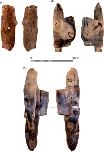
Despite differences in labelling and levels of patination, the blades showed no corresponding variations in technological attributes to suggest that they were derived from different scatters or were of different dates. The collection from Churchfields is dominated by blades that vary from 51mm to 158mm long (mean 90mm), 14–47mm wide (mean 27mm) and 3–18mm thick (mean 9mm); the largest blades were those labelled ‘Churchfields 1860’ (table 1). It is possible that small pieces were absent, but more likely that only large distinctive objects were retained. There are no cores or burnt pieces. The inclusion of a blade apparently made of Greensand chert, labelled ‘Churchfield b’, with those of flint is notable (fig 4a). The blade measures 116mm long and was removed from an opposed platform core, suggesting that it is not intrusive.
Principal attributes of comparable Late Upper Palaeolithic assemblages. Sample sizes are shown in brackets.

Artefacts: (A) Greensand chert blade; (B) conjoining blade and broken blade with distinctive striped inclusion; (C) two conjoining blades and broken blade. Photographs: Tom Westhead.

Narrow, plain butts, which were associated with limited use of platform abrasion and soft hammer mode, occur throughout the collection. It was not possible to distinguish between soft stone and soft organic percussion given the relatively low numbers of blades with retained proximal ends, including those with crushed and linear butts. Three striking platforms were faceted. Most blades were characterised by relatively straight or only slightly curving profiles. Two blades from ‘Churchfields a’ and ‘b’ retained traces of unifacial cresting, a technique that, as used here, was employed as a rejuvenation process on the flaking face of the core.
The raw material comprised good quality nodular flint, which must have been quite large according to the size of blades in the assemblage. Barton et al described exploitation of a flint nodule, 218mm long, from Nea Farm, large enough to have produced blades found at Churchfields.Footnote 14 Traces of core preparation are scarce; cortical remnants are minimal, but range from thin weathered material to a thicker chalky rind. The flint is otherwise not distinctive and provides no indication of how many nodules may have been represented or of a possible source. Barton et al concluded that blade production formed one of the activities represented at Nea Farm, but also conceded that blades made elsewhere may have been brought to the site.Footnote 15
Two sets of artefacts from the ‘Churchfields 1860’ group could be conjoined, including a blade 121mm long and a broken blade from a single platform core. These pieces (fig 4b) were made from flint with a distinctive striped inclusion, which could be most closely paralleled with flint from Nea Farm and Hengistbury Head and may have been derived from the same source.Footnote 16 A more impressive set of dorsal/ventral conjoins (fig 4c) comprised two unbroken blades, 158mm and 135mm respectively, and a portion of a broken blade. This reconstructed sequence demonstrated that alternating removals had been made from an opposed platform blade core of which the flaking face measured 197mm long.
DISCUSSION
The end of the Upper Palaeolithic period in Britain is marked by three distinctive phases of human activity: Late Upper Palaeolithic (Creswellian) and Final Upper Palaeolithic (Federmesser) with Long Blade industries potentially bridging the gap to the Early Mesolithic. These relatively brief periods of occupation coincided with warmer interludes within the Windermere Interstadial and near the end of the Younger Dryas stadial, between 13,000 and 10,000 bp. There is nothing to indicate with any confidence which of these periods may be represented by the collection from Churchfields given the small number of artefacts that are represented and the absence of diagnostic retouched tools. Nevertheless, the nature of the assemblage and its technological attributes points conclusively to a date somewhere within the Late Glacial Upper Palaeolithic. This can be shown by diagnostic features on the blades, which are long, relatively straight in profile and detached from elaborately shaped cores with opposed striking platforms. Typically, the blades have small punctiform or plain butts, with others carefully prepared using faceting to control the flaking angle. The absence of the use of the en éperon technique on the blade butts implies that Churchfields is not Creswellian and instead has better parallels with assemblages of Federmesser or later type.Footnote 17 This does not rule out the possibility of similarities with Long Blade industries, but clear examples of Federmesser technologies are represented nearby in the River Avon valley at Hengistbury Head and Nea Farm, and also on the banks of the River Test at La Sagesse Convent, Romsey.Footnote 18 Technological parallels, including large blades made with plain and faceted butts, platform abrasion, soft hammer mode and relatively straight profiles, can also be recognised in the early Federmesser of northern France.Footnote 19
Sites of the Federmesser complex are frequently characterised by nucleated scatters of flaking debris and tools. The site at Hengistbury Head was marked by spreads of flaking debris, which contained 13,419 pieces of worked flint of which numerous groups could be conjoined.Footnote 20 Horizontal spreads of flint debris were contained within areas approximately 5 × 4m2, while the pattern was repeated at Nea Farm, where 1,609 artefacts were distributed across 15–20m2. Presumed contemporary nucleated clusters have also been found at La Sagesse Convent, where two confined concentrations were found, and in the Colne valley at the slightly later sites of Three Ways Wharf, Uxbridge, and at Avington vi in the Kennet valley.Footnote 21 The scenario can be extended across Britain; two nucleated scatters, representing Late Upper Palaeolithic (Creswellian) and Final Upper Palaeolithic (Federmesser) were found on rising ground at the floodplain edge near the confluence of the Rivers Trent and Devon at Farndon Fields, Nottinghamshire.Footnote 22 Creswellian or early Federmesser sites with well-defined flint scatters have also been discovered fairly recently in the Wey Valley near Guildford, Surrey, and at Bradgate Park in Leicestershire.Footnote 23 Further northwards, other substantial open-air sites are known from Yorkshire and now even as far afield as Howburn Farm in South Lanarkshire, Scotland.Footnote 24 Comparable, well-defined flint clusters also extend to the European mainland, where many Federmesser sites have been documented.Footnote 25 It is therefore likely that the Churchfields assemblage also conformed to this model and, like scatter A at Three Ways Wharf, may have been partially interrupted or cut through by subsequent human activity, reducing the likely quantity of material that could have been recovered.Footnote 26
The discovery of most sites of this type may invariably include elements of serendipity, as at Nea Farm and La Sagesse, which were both discovered in machine excavated archaeological trial trenches.Footnote 27 Additional material has been found at Petersfinger on the east side of Salisbury, where a small collection of worked flints was recovered from a tree-throw hole during archaeological evaluation.Footnote 28 This collection, which contained a large blade produced from an opposed platform blade core, is also thought to fall somewhere within the same Upper Palaeolithic period, although the potential and date of the site have yet to be confirmed or realised by detailed excavation. Other similar undiscovered nucleated scatters are undoubtedly dotted along the banks of the river. Their presence cannot be predicted easily, although the increasing number of documented locations provide important clues – including close proximity to river confluences and the presence of fine-grained silty sediments – for further research.Footnote 29
Barton et al suggested that these consistently small, nucleated scatters, as identified at Nea Farm and La Sagesse, represented relatively short-term occupation and functioned as transitional ‘satellite’ camps that were linked to larger ‘residential’ sites, as represented at Hengistbury Head.Footnote 30 He argued that these two sites, spaced 19km apart, could be connected by foot or canoe within a day; Churchfields lies 22km away to the north of Nea Farm. The absence of burnt material at Nea Farm adds to the impression that activity was brief. Such a model may be applied at Churchfields, where the lack of burnt artefacts may indicate that this component was absent rather than assume that it was not recognised or collected.
Mobility may also be reflected in the selection of raw material. Flint occurs very locally at Churchfields but not at Nea Farm or Hengistbury Head, where nodules or finished products were introduced from locations possibly 10–12km away. However, transport of raw material is unlikely to have posed major problems for mobile populations living within individual river systems. Flint remains difficult to source; however, all three assemblages from the River Avon valley included artefacts that were characterised by distinctive stripy inclusions and may have originated, if not from the same location, from a similar geological source. Movement within the valley basin may also be indicated by the apparent presence of Greensand chert at Churchfields. This raw material, which was absent at both Nea Farm and Hengistbury Head, is readily available in the Vale of Wardour, approximately 8km to the west of Churchfields, and is present, in small quantities, within the Lower Palaeolithic assemblage from Milford Hill, Salisbury.Footnote 31 Campbell included a small number of Greensand chert and Carboniferous chert artefacts with material from a number of Upper Palaeolithic sites in Wales and western Britain; however, Jacobi challenged the identification of this raw material as applied to artefacts from Gough’s Cave, Cheddar, leaving the degree to which it may have been exploited further west currently unconfirmed.Footnote 32
The Upper Palaeolithic sites mentioned here are all located within river valley systems. Nea Farm was located on a terrace edge overlooking the valley floor, where good opportunities existed to observe game movements within the valley. Churchfields also occupied a low, south facing terrace bluff at the confluence the Rivers Avon and Nadder, two of the five rivers at Salisbury, which undoubtedly provided ample dispersal options for anyone using the river valley/banks as a means of communication. The location can be paralleled on the east side of Salisbury, at Petersfinger, at the confluence of the Rivers Avon and Bourne.Footnote 33 The scenario also extends to occupation at Farndon Fields, where activity was located on rising ground at the floodplain edge near the confluence of the Rivers Trent and Devon at Farndon, Nottinghamshire.Footnote 34 Such consistent patterns of behaviour emphasise the potential importance of terrace edge locations to Upper Palaeolithic groups. The nucleated nature of associated flaking clusters makes it difficult to predict with confidence where additional assemblages may be located; nevertheless, these patterns merit further consideration in future research. The Churchfields location may also have benefitted from an adjacent freshwater spring. Such natural fresh water sources may undoubtedly have been exploited and possibly revered by mobile hunting groups, as demonstrated by the prolonged use of Blick Mead, Amesbury, throughout the Mesolithic.Footnote 35
The passage of time, the lack of accurate record and the methods of recovery have diminished the amount of data that can be extracted from the Churchfields collection. The discoveries were made at a time before the concept and value of artefact refitting was contemplated. The application of this technique, pioneered by F C J Spurrell at Crayford, has elevated the importance of the Churchfields collection, indicating that it was originally relatively undisturbed and justifies publication 160 years after its initial discovery.Footnote 36 Furthermore, the assemblage was discovered soon after Palaeolithic hand axes were confirmed within the gravel in the Somme valley by Sir Joseph Prestwich and Sir John Evans, FSA in 1859 and before Sir John Lubbock, FSA, adapting Thomsen’s Three Age System, separated the Palaeolithic from the Neolithic periods within the Stone Age.Footnote 37 The concept of the Palaeolithic was therefore unrecognised when discoveries at Churchfields were made. It is to Blackmore’s credit that he embraced the idea of Palaeolithic stone tools, which were largely restricted to hand axes, of which he amassed large collections, although he was unable to appreciate the significance or age of these blades. The value can now be acknowledged when it is placed in a regional context that has been established by subsequent work. This development contributes to the distribution and use of the River Avon valley at the end of the Last Glaciation and merits inclusion in any future discussions of the period.
CONCLUSIONS
The presence of Upper Palaeolithic blades that lay hidden in Salisbury Museum for 160 years indicates the enormous value of preserving such archives, the true value of which museum curators are often innocently unaware, as sources of archaeological information. In this case it has been possible, through early mapping, to trace site location accurately and prove, using refitting, that the flint artefacts came from undisturbed contexts close to the river. Through further analysis it has also been possible to reconstruct the individual gestures of the flintknapper(s) and to link the Churchfield site not only with other Federmesser locations further downstream in the Avon valley but also upstream towards the headwaters of the fluvial basin. By mapping locations of this kind against topography and raw material sources we can begin to build a more complex picture of how humans operated in the Late Glacial landscape.
ACKNOWLEDGEMENTS
The authors wish to thank the following individuals for their substantial contributions to the completion of this project: to staff at the Salisbury Museum for access to the material and its removal to the offices of Wessex Archaeology for photography and study; to Jamie Wright for supplying cartographic information on the nineteenth-century extent of Churchfields; to Wiltshire and Swindon History Centre for permission to reproduce the Health Board map in fig 2; and to staff at Wessex Archaeology, principally Tom Westhead (photography), Kenneth Lymer, FSA (graphics) and Philippa Bradley (editorial) for contributing to the completion of the work. The authors also thank two anonymous referees for their comments.
ABBREVIATIONS AND BIBLIOGRAPHY
Abbreviations
- bp
-
before present
- HERs
-
Historic Environmental Records
- od
-
ordnance datum