

Almost invariably, attempts of states to consolidate control and jurisdiction over insular features signify the onset of a barrage of cartographic materials. On the one hand, carefully crafted maps can be key in resolving international disputes, indicating the intention of the parties and providing precise geographical data. On the other hand, too eager a resort to maps is dangerous, for “like statistics, they can ‘lie’ ”.Footnote 1 The dispute over the maritime features in the South China SeaFootnote 2 is no exception. Claimant states in South-East Asia have gathered a wealth of cartographic materials to back up their contentions, varying in substance and technical quality. One map that has recently resurfaced on the international level and made quite a splash is a Chinese official map of the South China Sea portraying the enigmatic “9-dotted-line” or “U-line”.Footnote 3 The forceful reassertion of this document on a state-to-state level elicits a host of questions as to its origins, what it means, and, ultimately, what its value is in the ongoing maritime rows.
The aim of this study is to offer an international legal analysis of the aforementioned map. The paper starts off with a brief discussion of the history of the cartographic piece and some recent developments in this regard. Thereafter, the legal merit of various (and at times fickle) interpretations of the U-line will be assessed. We will derive arguments predominantly from the law of the sea to demonstrate that the Chinese claims connected to the 9-dotted-line are debatable as a matter of international law. The focus will then turn to case law pertaining to cartographic evidence. Factors derived from this body of jurisprudence lead us to conclude that the map would in all likelihood be accorded fairly weak probative force before a court of law. Finally, we will show that even if the map were to be legally significant, it could not be used against other interested parties in the dispute as a result of the latter's effective protests.
I. Chinese map
A. Background
The origins of today's U-line date back to the activities of the Republic of China's (ROC) Land and Water Maps Inspection Committee, formed in 1933. Its responsibilities included the surveying and naming of islands in the South China Sea and the production of maps showing these islands as falling under Chinese sovereignty.Footnote 4
The first officially endorsed dotted-line originated from the aftermath of the Second World War. The cartographic piece in question was produced by the ROC's Department of the Territories and Boundaries of the Ministry of the Interior on December 1946.Footnote 5 On this map, the U-line consisted of eleven intermittent dashes enclosing the greater part of the South China Sea and its mid-ocean features.Footnote 6 Starting at the Sino-Vietnamese boundary, the first two segments passed through the Gulf of Tonkin. The third and fourth parts of the line separated the Vietnamese coastline from the Paracel Islands and Spratly Islands, respectively. The fifth and sixth segments on the interrupted line went past the James Shoal (4° N), the southernmost maritime feature claimed by the PRC and the ROC. Moving in the northeast direction, the subsequent two dashes were located between the Spratly Islands, on the one hand, and Borneo (Indonesia, Malaysia, and Brunei) and the Philippines (Palawan Province), on the other hand. The ninth, tenth, and eleventh segments separated the Philippines from the ROC.Footnote 7
Following the removal of the Nationalists from the mainland, cartography illustrating the same dashes can be found emanating from the PRC.Footnote 8 Thus, from then onwards, occurrences of the U-line could be observed on either side of the Taiwan Strait. One particular change needs to be noted: since 1953, PRC maps of the South China Sea depict nine instead of eleven segments (the dashes in the Gulf of Tonkin were erased).Footnote 9
B. PRC's Letter to the UN Secretary-General (7 May 2009)
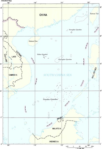
On the international level, the controversy surrounding the 9-dotted-line came to the fore before the United Nations (UN) in 2009 in connection with the Malaysian-Vietnamese joint submissionFootnote 10 and Vietnamese individual submissionFootnote 11 to the CLCS. The CLCS issues recommendations to coastal states wishing to establish the outer limit of their continental shelves beyond 200 nautical miles (nm).Footnote 12 The timing of the submissions by the Vietnamese and Malaysian governments can be explained by their respective deadlines in May 2009.Footnote 13 In response to these initiatives, the PRC officially submitted to the Secretary-General of the United Nations in two separate letters of the same date the following identical reaction, hereby for the first time endorsing the U-line, of which a map was attached,Footnote 14 at the international level in a state-to-state dispute:Footnote 15
China has indisputable sovereignty over the islands in the South China Sea and the adjacent waters, and enjoys sovereign rights and jurisdiction over the relevant waters as well as the seabed and subsoil thereof (see attached map). The above position is consistently held [sic] by the Chinese Government, and is widely known by the international community.Footnote 16
A reading of the note verbale allowed one scholar from Chinese Taipei to discern several Chinese assertions:
1. Sovereignty over the South China Sea islands and their adjacent waters (the attached map indicates the following maritime features within the interrupted line by name: Xisha Qundao,Footnote 17 Nansha Qundao,Footnote 18 Zhongsha Qundao,Footnote 19 and Dongsha QundaoFootnote 20).
2. Sovereign rights and jurisdiction over the relevant waters including their seabed and subsoil.
3. Consistency of the PRC's official position on maritime and territorial claims in the South China Sea.
4. Knowledge of third-party states as regards the PRC's maritime and territorial claims in the South China Sea.
5. The U-line delineates the Chinese claims of sovereignty, sovereign rights, and jurisdiction.Footnote 21
It nevertheless seems fair to state that the above-quoted official Chinese explanation, as far as the precise meaning of the attached map is concerned, remains ambiguous at best. Specifically, the exact legal nature of the maritime areas encompassed by the 9-dotted-line remains hazy, and this despite the Chinese “clarification”, as clearly indicated by the quite divergent reactions it has triggered at specialized conferences organized since then.Footnote 22
To our knowledge, only one state, the Philippines, has so far made an attempt at interpretation.Footnote 23 China swiftly replied with a new note verbale, which once more does little by way of providing clarity. In this new letter, dated 14 April 2011, China states that its “sovereignty and related rights and jurisdiction in the South China Sea” are supported by “abundant historical and legal evidence”.Footnote 24 What is apparent in the new diplomatic document is the lack of any reference to the map. Can we infer from this omission an abandonment of the 9-dotted-line? Certainly, such a volte-face cannot be presumed lightly. Moreover, PRC's recent instances of interference with, inter alia, Vietnamese and Philippine vessels, despite its current policy of assuaging concerns regarding the freedom of navigation in the South China Sea,Footnote 25 seemingly imply that its extensive claims as visualized on the map remain intact.
II. Claims
The PRC's letter of 7 May 2009, while possibly novel in its maritime aspects, repeats similar assertions put forward in the past as regards insular features.Footnote 26 Furthermore, several mainly Chinese and Taiwanese scholars have proffered their own interpretations of the 9-dotted-line. Amidst the confusion, one can only be certain of the fact that the Chinese assertions regarding the South China Sea do not exceed this demarcation.Footnote 27 These views and their legal merit will now be discussed.
A. Historic Claims
1. State practice
Although assertions of this ilk do not seem to feature in official PRC policy, Chinese Taipei has traditionally advocated this position on the U-line quite strongly, as evidenced in a host of declarations. For instance, in 1991 at one of the South China Sea Workshops, a representative of the Taipei Economic and Trade Office in Jakarta (Indonesia) declared:
The South China Sea is a body of water under the jurisdiction of the Republic of China. The Republic of China has rights and privileges in the South China Sea. Any activities in the South China Sea must acquire the approval of the Government of the Republic of China.Footnote 28
The 1993 Policy Guidelines for the South China Sea (endorsed by the Executive Yuan) note that:
On the basis of history, geography, international law, and the facts, the Spratly Islands, the Paracel Islands, Macclesfield Bank, and the Pratas Islands have always been a part of the inherent territory of the Republic of China. The sovereignty of the Republic of China over them is beyond doubt. The South China Sea area within the historic water limit is the maritime area under the jurisdiction of the Republic of China, in which the Republic of China possesses all rights and interests.Footnote 29
In 1994, a Minister of the Executive Yuan, Chang King-yu, stated that “the waters enclosed by the ‘U’-shaped line in the South China Sea are our historic waters and the ROC is entitled to all the rights therein” (emphasis added).Footnote 30
The Chinese Taipei policy is further deduced from protests lodged against the conduct of littoral states in the region. In response to the Malaysian occupation of two maritime features in the Spratly Islands and the Philippines’ decision to incorporate Scarborough Shoal on its map, Chinese Taipei stated:
The South China Sea is a body of water of the Republic of China. The Republic of China has all rights and privileges in the South China Sea. Any activities (including the discussion on joint cooperation or on Code of Conduct, etc.) in the South China Sea region must acquire the approval of the Government of the Republic of China. (emphasis added)Footnote 31
Certain pundits have cobbled together legal arguments for this tenuous claim.Footnote 32 For instance, Zhao Guocai observes:
China owns the historic right of islands, reefs, shoals, banks, and waters within the 9-dotted line. The South China Sea is regarded as the historic waters of China, which was universally acknowledged at that time. So far it has lasted for half a century.Footnote 33
2. Legal analysis
An examination of scholarly writings regarding historic claims relative to maritime areas gives rise to a great deal of terminological confusion. Germane concepts such as historic rights/historic title, historic waters, and historic bays are not easily distinguished and elucidated.Footnote 34 In order to avoid a lengthy and somewhat superfluous inquiry on the distinction between historic rights and historic title, suffice it to say that “historic rights” are the genus under which one can place the species “historic waters”. In turn, “historic bays” are a species of “historic waters”.Footnote 35 In the context of the 9-dotted-line, Chinese Taipei's behaviour seems to imply the recognition of historic waters as regards a substantial part of the South China Sea.
No universally accepted definition of historic waters exists, but in broad terms it denotes rights that accrue to a coastal state with respect to a maritime area or areas that the state would not normally enjoy. The extent of the rights concomitant to the historic waters can vary considerably. The legal conditions for acquiring historic waters were considered in a 1962 study carried out by the UN Secretariat's Office of Legal Affairs (OLA) at the request of the International Law Commission.Footnote 36 In the view of the OLA:
There seems to be fairly general agreement that at least three factors have to be taken into consideration in determining whether a State has acquired a historic title to a maritime area. These factors are: (1) the exercise of authority over the area by the State claiming the historic right; (2) the continuity of this exercise of authority; (3) the attitude of foreign States.Footnote 37
Chinese Taipei does not meet these criteria, and neither does the PRC for that matter. Conditions (1) and (2) require the claimant state to exercise authority via acts displaying sovereignty with a sufficient level of frequency and effectiveness. In relation to the area claimed, displays of authority can be described as infrequent at best. The freedom of fishing and navigation of other states remains unencumbered.Footnote 38 Consequently, no historic claim can be made. The theoretical requirements needed to fulfil condition (3) are uncertain. Essentially, the discussion pivots on whether other states need to acquiesce to the exercise of Chinese sovereignty over the South China Sea or whether the absence of any reaction from them is enough.Footnote 39 But no matter which view one subscribes to, both seem to agree that protest from foreign states can prevent the peaceful and continuous exercise of sovereignty, and this is precisely what has occurred with respect to the South China Sea (see section IV-B).
Some have retorted that claims must be considered in the light of the rules of international law that existed when the U-line map was drawn, i.e. 1946 (the so-called doctrine of intertemporal law).Footnote 40 This is quite peculiar, as this approach only weakens an already unconvincing contention. At that time, the legally recognized breadth of the territorial sea totalled a mere three nautical miles, making historic claims all the more exorbitant.Footnote 41 Given the fact that historic waters normally relate to either bays or a range of territorial waters,Footnote 42 it is therefore not surprising to note that a recent treatise on historic waters does not find it necessary to make any reference to the historic claim of the 9-dotted-line.Footnote 43 Moreover, even if for the sake of argumentation one were to envisage the hypothesis that China were able to make such an unprecedented extensive historic claim (quod non), it should be remembered that historic claims do not create an erga omnes regime, but rather depend, as stressed by one author recently, on express or implied recognition on a state-to-state basis.Footnote 44
On a final note, the prolific usage of the nomenclature “South China Sea” does not confer historic Chinese sovereignty.Footnote 45 Under international law, the mere naming of an area does not establish sovereignty over it.Footnote 46 The name has been vigorously protested by interested states, including Vietnam.Footnote 47 Foreign cartography uses the name South China Sea simply in accordance with the maritime nomenclature published in the International Hydrographic Organization's Limits of Oceans and Seas (1953), which has “no political significance whatsoever”.Footnote 48 Thus, this choice of terminology does not imply recognition of Chinese sovereignty on the part of Western states. Also, the Chinese have historically employed different names for this maritime area such as “Giao Chi Sea” (Song and Ming dynasties) and “South Sea” (Qing dynasty (1905), Republic of China (1913), and People's Republic of China (1952 and 1975)).Footnote 49
3. New developments
Recent developments might render this discussion moot. Indeed, it could very well be that Chinese Taipei is steadily abandoning its long-standing thesis. Statements in recent years hint at a change in stance, aligning Chinese Taipei's policy on this matter with that of the PRC. References to historic rights/waters are absent whilst the focus seems to be on territorial sovereignty over the islands and their territorial waters.Footnote 50 The most recent example is a May 2009 statement protesting the Vietnamese and Malaysian-Vietnamese submissions to the CLCS:
The Government of the Republic of China reiterates that the Diaoyutai Islands, Nansha Islands (Spratly Islands), Shisha Islands (Paracel Islands), Chungsha Islands (Macclesfield Islands), and Tungsha Islands (Pratas Islands) as well as their surrounding waters are the inherent territories and waters of the Republic of China based on the indisputable sovereignty titles justified by historic, geographic and international legal grounds. Under international law, the Republic of China enjoys all the rights and interests over the foregoing islands, as well as the surrounding waters and sea-bed and subsoil thereof.Footnote 51
B. Insular Claims
1. Interpretation 1: All insular features within the U-line are PRC/Chinese Taipei territory
An early proponent of this territorial interpretation, the Indonesian diplomat Hasjim Djalal, whilst acknowledging the “enigmatic” nature of the Chinese line, based his findings on a careful analysis of the PRC's statements, particularly those formulated during a 1979 meeting of the International Civil Aviation Organization (ICAO).Footnote 52
Smith notes that the mid-ocean features falling within these “lines of allocation” are those for which the Chinese claim sovereignty. He emphasizes that the dashes do not suggest any maritime boundary claims and would have no impact on the resolution of maritime boundary disputes.Footnote 53
Dzurek too believes that the U-line does not demarcate the borders of Chinese maritime jurisdiction, with this belief posited on a cartographic argument, namely, the fact that the dashes separating Malaysia and the Natuna Islands deviate from the agreed Indonesian-Malaysian continental-shelf delimitation line.Footnote 54
As indicated above, contemporary Chinese Taipei state practice seems to evidence a shift toward this position.
The delicate question of to whom the islands in the South China Sea belong, which entails rigorous analysis of a complex factual matrix and the application of manifold legal concepts (such as discovery, critical date, and effectivités), would take us too far from our present theme.Footnote 55 Bearing that in mind, it is appropriate to stress here that the Chinese map per se cannot constitute a valid territorial title to the islands. In Burkina Faso/Mali, the International Court of Justice (ICJ) provided its “definitive”Footnote 56 explanation of the evidentiary value of cartographic evidence:
[M]aps merely constitute information which varies in accuracy from case to case; of themselves, and by virtue solely of their existence, they cannot constitute a territorial title, that is, a document endowed by international law with intrinsic legal force for the purpose of establishing territorial rights. Of course, in some cases maps may acquire such legal force, but where this is so the legal force does not arise solely from their intrinsic merits: it is because such maps fall into the category of physical expressions of the will of the State or States concerned. This is the case, for example, when maps are annexed to an official text of which they form an integral part. Except in this clearly defined case, maps are only extrinsic evidence of varying reliability or unreliability which may be used, along with other evidence of a circumstantial kind, to establish or reconstitute the real facts.Footnote 57
This obiter dictum has been approvingly cited in a host of contentious cases.Footnote 58 Some have read this passage as a “categorical” refutation of the concept of cartographic title.Footnote 59 In any event, the small windowFootnote 60 the Court seems to leave open (“maps … annexed to an official text of which they form an integral part”) refers to instruments such as treatiesFootnote 61 and is thus not applicable in casu.
2. Interpretation 2: The U-line is the boundary line of the exclusive economic zone (EEZ) generated from South China Sea islands
A number of Chinese scholars seem to support this theory, although their reasoning is somewhat dissimilar and often linked to the historic rights/waters thesis. Zhao Lihai notes:
[T]he nine-dotted line indicates clearly Chinese territory and sovereignty of the four islands in the South China Sea and confirm China's maritime boundary of the South China Sea Islands that have been included in Chinese domain at least since the 15th century. All the islands and their adjacent waters within the boundary line should be under the jurisdiction and control of China.Footnote 62
Jiao Yongke alleges:
The water areas within China's Southern Sea boundary line constitute water areas over which China has a historic proprietary title, they constitute China's specific exclusive economic zone, or historic exclusive economic zone, hence it ought to have the same status as the EEZ under UNCLOS [United Nations Convention on the Law of the Sea] provisions.Footnote 63
Finally, Zou Keyuan believes that the PRC has asserted a historic claim but that this claim is “equivalent to the legal status of EEZ or continental shelf”.Footnote 64
This second explanation of the intermittent dashes is entirely contingent upon the first. It follows from the principle “the land dominates the sea” that this approach is necessarily premised on Chinese sovereignty over the maritime features in the South China Sea.Footnote 65 Proponents of this thesis see the U-line as a maritime boundary connecting the limits of the EEZ or continental shelf that originate from the islands. A variety of questions arise. A first thorny problem relates to the delimitation of such sea areas. After all, a coastal state cannot simply impose its delimitation upon others states in a unilateral fashion. The validity of such an action will depend upon compliance with international legal norms.Footnote 66
Furthermore, are the maritime features even able to generate maritime zones (irrespective of who the rightful owner is)? All will depend on whether the insular features qualify as islands in the juridical sense. The 1982 ConventionFootnote 67 contains a provision to this end, Article 121, which states the following:
1. An island is a naturally formed area of land, surrounded by water, which is above water at high tide.
2. Except as provided for in paragraph 3, the territorial sea, the contiguous zone, the exclusive economic zone and the continental shelf of an island are determined in accordance with the provisions of this Convention applicable to other land territory.
3. Rocks which cannot sustain human habitation or economic life of their own shall have no exclusive economic zone or continental shelf.Footnote 68
Land surfaces in the South China Sea will therefore generate the additional EEZ (and continental shelf) only if they meet the stringent requirements set out above.Footnote 69 It so happens that the insular quality of a range of maritime features in the South China Sea have been called into question. Oude Elferink cautiously finds that “at least some of the islands in the South China Sea have an EEZ and continental shelf. Other insular formations can almost certainly be considered to fall under the sway of Article 121(3) [rocks].”Footnote 70 If it turns out that these land surfaces are not islands, (at least part of) the EEZ or continental-shelf interpretation of the U-line is without legal merit.
In this respect, it is worthwhile briefly mentioning the steps recently undertaken by the PRC on the international level in favour of the Common Heritage of Mankind by trying to protect the Area against the unjustified encroachment of certain states.Footnote 71 In essence, these interventions were aimed against Japan's submission to the CLCS based on Okinotorishima in the Pacific Ocean.Footnote 72 But this action immediately backfired with respect to the South China Sea, where Indonesia questioned the Chinese 9-dotted-line exactly on the basis of the representations made by this country before the 2009 meeting of State Parties as well as the International Seabed Authority, namely, that rocks which cannot sustain human habitation or economic life of their own do not generate an EEZ or a continental shelf.Footnote 73
No matter how interesting these developments may be, this imperative, but rather fact-laden and technical, inquiry into the exact legal status according to Article121(3) of the 1982 Convention of the different South China Sea features exceeds by far the scope of our study.
III. Factors weakening the map's probative force
According to a well-documented rule,Footnote 74 the international adjudicator enjoys particularly wide discretion in determining the weight of evidentiary material.Footnote 75 Bearing in mind this principled freedom, we have examined judicial precedentsFootnote 76 concerning maps in order to infer factorsFootnote 77 that are typically used by a judge or arbitrator to assess the probative force of cartographic evidence. It should be stressed that in doing so, we rely on both maritime and territorial precedents without distinction. While it is true that the principles governing acquisition of maritime spaces and maritime delimitation differ considerably from those underpinning territorial acquisition and delimitation,Footnote 78 this substantive question (the applicable legal regime) is separate from the question of evidence (maps). Moreover, doctrine does not seem to make any meaningful distinction between territorial and maritime maps in categorizing evidentiary rules, and the ICJ has cited jurisprudential rules fleshed out in territorial cases when assessing maps submitted by parties engaged in disputes containing a maritime element.Footnote 79
The following factors demonstrate the inherent evidentiary shortcomings of the Chinese 9-dotted-line.
A. Cautious Approach to Cartographic Evidence
As a preliminary observation, it should be pointed out that the general tendency is such that international courts and tribunals refrain from rendering rulings based merely on cartographic findings.Footnote 80 Although accurate maps reflecting the intentions of the parties can indeed constitute “a solid and constant basis for discussion” the absence of which “is an inconvenience much to be regretted”,Footnote 81 they will often play a secondary role of corroborating other evidence that points in the same direction.Footnote 82 Returning to the Burkina Faso/Republic of Mali decision:
[M]aps can still have no greater legal value than that of corroborative evidence endorsing a conclusion at which a court has arrived by other means unconnected with the maps … except when the maps are in the category of a physical expression of the will of the State, they cannot in themselves alone be treated as evidence of a frontier, since in that event they would form an irrebuttable presumption, tantamount in fact to legal title. The only value they possess is as evidence of an auxiliary or confirmatory kind, and this also means that they cannot be given the character of a rebuttable or juris tantum presumption such as to effect a reversal of the onus of proof.Footnote 83
This wary stance has been detected and documented in authoritative scholarly opinion,Footnote 84 and in certain instances has been met with considerable approval.Footnote 85
B. Incompatible Maps
Setting the facts straight is strenuous when presented with mutually contradictory assertions.Footnote 86 Quite similarly, when cartographic materials contradict one another, they lose credibility.Footnote 87 As stated by the ICJ in the Kasikili/Sedudu case: “in the light of the uncertainty and inconsistency of the cartographic material submitted to it, the Court considers itself unable to draw conclusions from the map evidence produced in this case.”Footnote 88
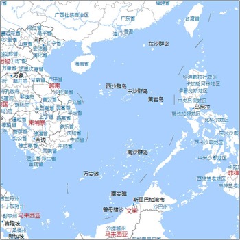
Maps showing the 9-dotted-line paint a picture of the South China Sea different from cartographic evidence and other materials of the regional littoral states. It would be hard to gain an accurate understanding of maritime and political boundaries based solely on a juxtaposition of these maps. Additionally, portrayals of the U-line are not consistent. As mentioned above, the U-line in PRC cartography prior to 1953 normally consists of eleven dashes,Footnote 89 whereas later versions of the dotted line consist only of nine segments. A recent electronic map placed online by the Chinese State Bureau of Surveying and Mapping on 21 October 2010 again adds one more segment to the North between Taiwan and the Ryukyu group, of which Yonaguni Island is the most western island, all belonging to Japan.Footnote 90 No reasons have been given for the mysterious removal of two dashes in the past or the new tenth segment added recently.Footnote 91
C. Incoherent/Ambiguous Cartographic Symbols
Ambiguous cartography has surfaced in arbitral proceedings in the past. In the Eritrea/Yemen Arbitration, Eritrea had submitted maps depicting a dotted line in support of their claims. The Tribunal made short shrift of the party's evidentiary approach:
In some instances the Tribunal cannot agree with the characterization of the maps sought by the Party introducing it. Moreover, the Tribunal is unwilling, without specific direction from the map itself, to attribute meaning to dotted lines rather than to colouration or to labelling. The conclusions on this basis urged by Eritrea in relation to a number of its maps are not accepted.Footnote 92
Naturally, the analogy of this case to the U-line, the lack of a map legend, and cryptic wording contained in the PRC's letter to the UN Secretary-General is readily made. The perplexity is all the greater because the depiction of the 9-dotted-line deviates from international cartographic standards developed by the International Hydrographic Organization precisely for the purpose of clarity.Footnote 93 China, it should be remembered, is a member of this international organization.Footnote 94
D. Unclear Intent
As rightly pointed out by Judge Oda in his separate opinion in Kasikili/Sedudu, “a claim to territory can only be made with the clear indication of a government's intention, which may be reflected in maps. A map on its own, with no other supporting evidence, cannot justify a political claim” (emphasis added).Footnote 95In casu, the criterion of discernible intent on the part of the PRC government is not adequately fulfilled. The variety of interpretations of the U-line offered by legal scholars as well as the PRC's ambiguous note verbale de dato 7 May 2009 bear witness to this conclusion. Besides confusing sentence structures, terms employed in the note verbale, namely “relevant waters” and “adjacent waters”, are particularly puzzling as they do not appear anywhere in UNCLOS. The ostensibly deliberate vagueness is exacerbated, for the PRC has yet to pass legislation giving the U-line any effect in its domestic legal order.Footnote 96
Even if one could unearth the PRC's intention behind the map, the legal implications thereof should not be overestimated. Turning back to Judge Oda's aforementioned writings:
A map produced by a relevant government body may sometimes indicate the government's position concerning the territoriality or sovereignty of a particular area or island. However, that fact alone is not determinative of the legal status of the area or island in question. The boundary line on such maps may be interpreted as representing the maximum claim of the country concerned, but does not necessarily justify that claim.Footnote 97
E. Lack of Neutrality
When a map is drawn up by an impartial expert, its probative value tends to increase.Footnote 98A contrario, cartographic materials produced at the behest of one of the parties in a dispute will be viewed with more suspicion, and thus reliance on such a document should be the exception not the rule.Footnote 99 The arbitrators in the Beagle Channel Arbitration commented along these lines:
While maps coming from sources other than those of the Parties are not on that account to be regarded as necessarily more correct or more objective, they have, prima facie, an independent status which can give them great value unless they are mere reproductions of—or based on originals derived from—maps produced by one of the Parties, or else are being published in the country concerned by, or on behalf, or at the request of a Party, or are obviously politically motivated. But where their independent status is not open to doubt on one or other of these grounds, they are significant relative to a given territorial settlement where they reveal the existence of a general understanding in a certain sense, as to what that settlement is, or, where they conflict, the lack of any such general understanding.Footnote 100
The lack of neutrality is patently evident with respect to the 9-dotted-line. As discussed in section II-A, the history of the U-line can be traced back to an internal commission established by the ROC government to update the Chinese map and reassert its position. Such a unilaterally appointed and staffed governmental body can hardly be deemed impartial vis-à-vis other interested states in the South China Sea region. It should not be forgotten that conscientious map-makers can be used for deceitful purposes:
[A] map-maker … may be employed to reveal what a particular State such as his own asserts to be the full measure of its territorial domain, regardless of the propriety of the assertion and without intimation that the portrayal depicts the scope of a claim rather than the position of an accepted boundary. Through subsequent copying and reproduction by unsuspecting cartographers not only are these erroneous accounts perpetuated but the very fact of repetition tends to endow them with legal sanction by producing a large number of maps unanimous in their testimony.Footnote 101
F. Technical Imprecision
In his treatment of the evidentiary value of maps, De Visscher included the following criteria: “les garanties d'exactitude géographique intrinsèques de la carte … sa précision au regard des points contestés”.Footnote 102 According to Brownlie, “a map has probative value proportionate to its technical qualities”.Footnote 103
Case-law also points to the requirement of technical precision in maps.Footnote 104 In the Island of Palmas case, sole arbitrator Max Huber wrote that: “[t]he first condition required of maps that are to serve as evidence on points of law is their geographical accuracy.”Footnote 105
The ICJ opined that:
The actual weight to be attributed to maps as evidence depends on a range of considerations. Some of these relate to the technical reliability of the maps. This has considerably increased, owing particularly to the progress achieved by aerial and satellite photography since the 1950s. But the only result is a more faithful rendering of nature by the map, and an increasingly accurate match between the two. Information derived from human intervention, such as the names of places and of geographical features (the toponymy) and the depiction of frontiers and other political boundaries, does not thereby become more reliable. Of course, the reliability of the toponymic information has also increased, although to a lesser degree, owing to verification on the ground; but in the opinion of cartographers, errors are still common in the representation of frontiers, especially when these are shown in border areas to which access is difficult.Footnote 106
In the light of these views, the advent of modern technology could increase judges’ recourse to map evidence. An excellent case in point is the ICJ's 2004 advisory opinion on the Israeli Wall in which it relied (in part) on an electronic map posted on the Israeli Ministry of Defence website to pinpoint the current and future route of the wall in Palestinian territories.Footnote 107 Conversely, it does not seem that the Chinese map can meet stringent technical standards. Although the Chinese interrupted line generally follows the 200-metre isobath, it has so far never been precisely demarcated, thus lacking accurate geographical co-ordinates.Footnote 108 In addition, there seems to be some slight inconsistency among PRC maritime cartographic materials: the endpoints of the different segments that make up the line vary (variations have been found ranging from 1 to 5 nm).Footnote 109 But even the location of the segments themselves is sometimes clearly at variance with those found on the Annex I map.Footnote 110 Moreover, because it concerns lines at sea, satellite imagery will not be very helpful either.
An additional element contributing to the inaccuracy of the Chinese map is its excessively small scale. The ICJ has lamented maps drawn to an insufficient scale. A prime illustration can be found in Land, Island and Maritime Frontier Dispute:
Honduras has produced a second map, of 1804, showing the location of the ecclesiastical parishes of the province of San Miguel in the Archdiocese of Guatemala. The scale of this map is however insufficient to make it possible to determine whether the course of the last section of the river Goascoran is that asserted by El Salvador, or that asserted by Honduras.Footnote 111
Similar problems have been presented before arbitral tribunals. For instance, the Eritrea-Ethiopia Boundary Commission held: “[m]oreover, much of the map evidence is on so small a scale, or so devoid of detail, that it can only be treated as ambiguous in this respect.”Footnote 112
Finally, it is to be noted that the Chinese map does not contain any indication of the datum (i.e. a reference employed in geodesy for measurement) used, which seems to be a crucial element in evaluating the technical precision of any maritime boundary.Footnote 113
IV. Non-opposability of the map vis-à-vis other regional states
A. Applicable Standard
Even if one accepts that the 9-dotted-line is an erroneous portrayal of reality, that does not mean that it can be cast aside forthwith. This point was elucidated in the Beagle Channel case:
the importance of a map might not lie in the map itself, which theoretically might even be inaccurate, but in the attitude towards it manifested—or action in respect of it taken—by the Party concerned or its official representatives.Footnote 114
The judges in Temple of Preah Vihear had a more pronounced take, sending a clear warning signal as to the potential effects of inadvertence in the face of cartographic assertiveness:
[I]t is clear that circumstances were such as called for some reaction, within a reasonable period, on the part of the Siamese authorities, if they wished to disagree with the map or had any serious question to raise in regard to it. They did not do so, either then or for many years, and thereby must be held to have acquiesced. Qui tacet consentire videtur si loqui debuisset ac potuisset.Footnote 115
Another instance of the linkage between maps and acquiescence was restated more recently by the Eritrea-Ethiopia Boundary Commission: “[a] map per se may have little legal weight: but if the map is cartographically satisfactory in relevant respects, it may, as the material basis for, e.g., acquiescent behaviour, be of great legal significance.”Footnote 116
Of course, the fact patterns underlying the above-mentioned cases are wholly different from that with which we are faced, making it debatable whether the precedents could even apply here. In casu we are dealing with a purported maritime boundary, the establishment of which is, in the words of the ICJ, “a matter of grave importance and agreement is not easily to be presumed”.Footnote 117 Furthermore, as observed by Strupp:
[T]his strange U-shape claim was so abnormal and so exorbitantly outside reality during the decades 30 to 60 that it is not conceivable that by way of “acquiescence with regard to map claims” a (tacit) recognition by the foreign states community of those “extremely irregular” pretensions, by application of rule qui tacet consentire videtur si loqui debuisset ac potuisset or else, could seriously come under examination.Footnote 118
Strupp also observes that:
In the utterly eccentric “moon claim”-like circumstances of the SCS [South China Sea] “U-shaped line” [there] evidently exists no rational basis at all for such enormously high degree of “hyper-sensitivity” on behalf of states confronted with adverse map claims in terms of “acquiescence”.Footnote 119
It would, however, be prudent to adopt an intermediate approach. Having examined a large body of state practice, Blum, in his influential work on historic titles, comes to the following conclusion:
[R]ecent instances of protests lodged against “map claims” seem to indicate that States do, in fact, “keep a vigilant watch over the maps published by the civilized nations” … On the whole, it seems to emerge that States will be imputed with knowledge of each other's domestic legislative activities and other acts done under their authority, and that the plea of ignorance will be accepted only in the most exceptional circumstances. States desirous of reserving their rights will therefore be well advised to follow with a substantial amount of self-interested awareness the official acts of other States and to raise an objection to them—through the legitimate means recognized by international law—should they feel that their rights have been affected, or are likely to be affected, by such acts.Footnote 120
B. Protest/Lack of Acquiescence
Assuming that the prospect of implied acquiescence looms large, coastal states are required to express their disapproval of the Chinese U-line policy and its underlying contentions. Some Chinese scholars have alleged that the international community has not voiced its dissent so as to prevent the solidification of Chinese pretensions in the South China Sea:
Upon the declaration of the nine-dotted line, the international community at no time expressed dissent. None of the adjacent states presented a diplomatic protest. This silence in the face of a public declaration may be said to amount to acquiescence, and it can be asserted that the dotted line has been recognized for half a century. In recent years, however, several Southeast Asian countries, which have been involved in sovereignty disputes of the South China Sea, have questioned the juridical status of the nine-dotted line.Footnote 121
Zhao Guocai maintains: “[s]ince the declaration of the 9-discontinued-and-dotted line, the international society at that time had not put forward any dissents. Neither had the adjacent States raised any diplomatic protests on the 9-dotted line. These amounted to acquiescence.”Footnote 122
This international acquiescence has been very much doubted.Footnote 123 Taking Vietnam as a case in point, we can observe that these statements are unconvincing. Examples include:
1. An objection to China's pretensions by stating that it would “not recognize any so-called ‘historical interests’ which are not consistent with international law and violate the sovereignty and sovereign rights of Vietnam and Vietnam's legitimate interests in its maritime zones and continental shelf in the East Sea”.Footnote 124
2. A declaration in response to the PRC's 2009 note verbale:
The Hoang Sa (Paracels) and Truong Sa (Spratlys) archipelagoes are part of Viet Nam's territory. Viet Nam has indisputable sovereignty over these archipelagoes. China's claim over the islands and adjacent waters in the Eastern Sea (South China Sea) as manifested in the map attached with the Notes Verbales CLM/17/2009 and CLM/18/2009 has no legal, historical or factual basis, therefore is null and void.Footnote 125
3. A request to remove data from China's online map service depicting the U-line (mentioned above) on two occasions.Footnote 126
4. Recent protests against Chinese interference with Vietnamese vessels, in which the legality of the 9-dotted line was explicitly refuted.Footnote 127
5. At the occasion of the last Meeting of State Parties to UNCLOS, Vietnam reiterated its objection to the 9-dotted line under item 14 of the Agenda.Footnote 128
Such conduct must comply with the international legal criteria necessary to imbue acts of protest with legal effect so that the U-line cannot be used against the protesting state. Nevertheless, it seems unfeasible to apply these criteria to the early manifestations of the U-shaped line in the light of China's ambiguous position vis-à-vis the map and what it truly signifies. After all, it is only possible to act by way of protest once the opposing state has made an official and intelligible claim. This idea is reflected in the notion of the “notoriety” of the act or fact in question.Footnote 129 We have dealt in detail with the enigmatic character of the 9-dotted-line and the repercussions of ambiguous intent on the Chinese side. Thus, it is only possible to object to visible and comprehensible Chinese U-line assertions in the rare instances that they occur (e.g., the 2009 PRC letter to the UN Secretary-General). The passage of time, the following criterion, is contingent upon the former. Arguendo, that the notoriety of the 9-dotted-line were established, the nature of acquiescence is such that it tends to be accepted only following a prolonged period of passivity.Footnote 130 Conspicuous examples are Fisheries and Right of Passage over Indian Territory cases in which the ICJ inferred acquiescence from over sixty and 125 years of silence, respectively.Footnote 131 The requirement of clear intent has also been fulfilled in that the Vietnamese declarations are unequivocally aimed at preventing the coming into being of new Chinese legal entitlements. Also, the criterion that protest must be consistent and uninterrupted can be said to have been complied with, as illustrated by the content of the above-mentioned notes of protest.Footnote 132
V. Conclusion
In this contribution, we have attempted to uncover some of the legal uncertainties shrouding the dashes on the Chinese map of the South China Sea. Our analysis has brought us to the conclusion that the U-line, whether interpreted as a territorial or a maritime manifestation, clearly lacks precision, and thus poses problems if kept as part and parcel of PRC as well as Chinese Taipei's official policy. If the considerable body of case-law is anything to go by, cartography displaying the 9-dotted-line would not fare well as evidentiary material in a hypothetical court case. While it can be observed that some see a new trend emerging that militates in favour of leniency vis-à-vis maps,Footnote 133 we would submit that such contentions are rather precipitate. It remains unchanged that maps other than those annexed to treaties are to be received with understandable prudence and will be assessed in function of their merits.
But there is a more fundamental issue at stake here. Maintaining a unilateral claim over an extended period of time without due consideration for the rights of other interested parties is tantamount to imposing a fait accompli. This plainly flies in the face of international law, which prevents the strong states from claiming their “lion's share” to the detriment of their weaker neighbours.Footnote 134 Adherence to the 9-dotted-line is also out of step with the current government regime,Footnote 135 which includes workshopsFootnote 136 and (proposals for) co-operation in the field of environmental and biodiversity protection.Footnote 137 One pragmatic solution that has gained currency over the years is seeking ways of achieving the joint development of resources. This involves setting aside territorial and maritime disputes and concluding provisional arrangements “without prejudice” to the final delimitation outcome.Footnote 138 Fortunately, the PRC, Chinese Taipei, and other regional actors have made use of these multilateral mechanisms and continue to do so in a fruitful manner. Our hope is that claimant states abandon exceedingly assertive cartographic assertions and rather focus their energies on mutually beneficial outcomes as regards the South China Sea on the basis of UNCLOS.
Appendix I
Map of the U-line (9 segments) attached to the following two sources: People's Republic of China, Letter to the Secretary-General of the United Nations, New York, 7 May 2009, CML/17/2009, available at: 〈www.un.org/Depts/los/clcs_new/submissions_files/mysvnm33_09/chn_2009re_mys_vnm_e.pdf〉; and People's Republic of China, Letter to the Secretary-General of the United Nations, New York, 7 May 2009, CML/18/2009, available at: 〈www.un.org/Depts/los/clcs_new/submissions_files/vnm37_09/chn_2009re_vnm.pdf〉.

Appendix II
Snapshot of the U-line (10 segments) taken from: Chinese State Bureau of Surveying and Mapping, Map World, available at:〈www.chinaonmap.cn〉.