

In July 1989, eleven years after the first architectural proposals were tabled, the rural Portuguese town of Lourinhã, seventy kilometres north of Lisbon, opened a new farmers’ market.Footnote 1 Considering the market hall a centre of both social and economic activity, the municipal government boasted that the new facility was in a ‘privileged location’ on the ring road connecting Lourinhã to larger centres like Lisbon and Peniche; that the market hall was an integral part of the town's development of a new municipal centre that included a new bus-station, new municipal offices and a soccer field; and that visitors would find the cleanest environment possible.Footnote 2 The municipal government heralded the new facility as an important step towards building ‘a different Lourinhã . . . a European Lourinhã’.Footnote 3
Portugal, like Lourinhã, was undergoing a dramatic political, social and economic transformation. In the 1950s Portugal was a predominantly rural society under an inward looking and conservative dictatorship that maintained an overseas empire despite economic frailty. But, by the early 1990s, Portugal had developed a semi-industrialised economy, while a democratically elected government, whose future was bound to the European Union (EU), governed society.Footnote 4 This process included a bloodless political revolution, the Carnation Revolution, which, on 25 April 1974, ended the dictatorial Estado Novo (1933–1974), a corporatist regime, ruled first by António Oliveira Salazar and later Marcello Caetano; a bloody, drawn out and costly colonial war during the 1960s and 1970s; and Portugal's entrance into the European Economic Community (EEC) in 1986.Footnote 5 This latter event should be understood as the culmination of a process that moved the country economically closer to mainstream Europe, starting with Portugal's admission to the European Free Trade Area (EFTA) and the Organisation for Economic Co-Operation and Development (OECD) in 1960.
These changes resulted in a series of economic and infrastructure modernisations that reordered many of Portugal's public spaces. This article uses Lourinhã’s market hall as a case study in order to understand the ways in which public space was reordered as Portugal democratised and modernised.Footnote 6 By deconstructing the development of Lourinhã’s market hall, it becomes evident that, in the 1980s, democratic Lourinhã’s municipal government, the Câmara Municipal da Lourinhã (CML), was engaged in a program of spatial and cultural management, whose origins can be found in the 1960s under Portugal's dictatorship. As António Costa Pinto reminds us, the Estado Novo consistently employed ideological and social instruments of control like its bureaucracy, its corporative structure, its schools, its propaganda and the Church to intervene in everything from culture to the economy.Footnote 7 The goal was to control the ‘desynchronizing developmental variables’ of economic and social development in order to maintain the status quo. Between the 1930s and 1950s Portugal had the lowest rates of urbanisation, literacy, industrialisation and economic development of all the Western European countries.Footnote 8 These were the consequences of the dictatorship's ‘model of programmed stagnation’.Footnote 9
Programmed stagnation was reflected in the urban landscape, which was highly politicised, in the cultural celebration of Portugal's pastoral roots and the humble peasant home.Footnote 10 However, under pressure from several sources, including the colonial war and EFTA membership, Portugal's dictatorship worked to modernise its infrastructure. This, however, did not neuter the politico-cultural importance of the landscape. On 28 May 1966, for example, Portugal celebrated the fortieth anniversary of the ‘Revolução Nacional’.Footnote 11 The so-called revolution ended the ill-fated Portuguese First Republic (1910–1926) with a military coup that would in 1928 bring Salazar to government as Portugal's technocratic saviour from financial mismanagement. The celebrations were headlined by the 6 August inauguration of the Salazar Bridge (Ponte Salazar), the ‘greatest feat of engineering executed in Portugal’.Footnote 12 Spanning the Rio Tejo, the Ponte Salazar (today the Ponte 25 de Abril in honour of the revolution that toppled Salazar's Estado Novo) was heralded as a triumph of the Portuguese Nation and a symbol of the capabilities and patriotism of the dictatorship.Footnote 13 Its proximity to Belém, with the Monument to the Discoveries, the Hieronymite monastery of Santa Maria de Belém (where Vasco da Gama and the national poet, Camões, are interred) and the medieval defensive Tower of Belém, further cemented the Ponte Salazar's importance as a symbol of the Portuguese nation.Footnote 14
Infrastructure projects like the Ponte Salazar would become the lasting legacy of the commemorations of the fortieth anniversary of 28 May. Lourinhã would use the occasion to embark on its own program of urbanisation that would define the next four decades of the town's development. In a document sent to the District of Lisbon, the level of government directly responsible for approval of municipal projects, the CML explained that the anniversary was an opportunity to address the ‘most urgent’ issues and upgrade ‘fundamental’ infrastructure and facilities.Footnote 15 The water and electricity networks were to be extended in order to expand schools, modernise the sewage and water treatment systems and build new public buildings, including a large hotel at Lourinhã’s beach town, Praia da Areia Branca (PAB), a courthouse, a new town hall, a bus station, a cinema and an agricultural school, as well as roads along the Atlantic coast, and a Pousada, one of a chain of government-run hotels in converted historic sites, this one in the historic fort at the south end of PAB, called Paimogo.Footnote 16 Over the next thirty-five years, Lourinhã would implement many of these projects. After finishing a post office and campground in 1966, Lourinhã would open its courthouse in 1980, its new market hall and bus station in 1989 and its new town hall anchoring a new central square in 2001. Urban development must be understood as part of a project of national and state renovation underway in a 1960s Portugal whose government's legitimacy was questioned by the colonial wars in Africa, and whose role was being reassessed as part of a general renegotiation of the social contract in post war Western Europe that would continue into the 1980s as the CML introduced the ‘New Lourinhã’.
This article focuses on Lourinhã’s contemporary built environment and argues that the development of the urban landscape (which began as a project of the dictatorship), with its new town centre and new market hall, whose origins are found under the dictatorship, became important sites for the expression of what Portuguese political culture came to value as representations of modern and democratic Portugal in the late 1980s. Modern Lourinhã was to order and rationalise its landscape, allowing for urban management by designating spaces for various purposes. This was a long-term project, meaning that despite ruptures in Portuguese political structures and mechanisms, the country's political culture and modernisation was marked by continuity as Portugal transitioned to European social democracy in the 1980s. In other words, the revolution of 1974, although without doubt a rupture in many ways, did not significantly shift Portugal's development, as exemplified by urbanisation and projects like Lourinhã’s new market hall.
This article comprises three sections, each helping to demonstrate how Lourinhã and Portugal achieved the organisation of its space. First, Portugal and Lourinhã’s political, economic and urban development will be considered in a historiographical context, highlighting certain deficiencies in the country's urban infrastructure and how they were eliminated as Portugal concurrently transitioned from dictatorship to democracy. Next, the market hall project will be discussed with particular attention paid to electrical infrastructure as a basic service that developed and supplemented the drive to standardise space. Electricity as a tool for standardisation was championed not only by the state but also by locals who complemented the usual sources of civic participation: priests, the neighbourhood commissions after 1974 and other political activists.Footnote 17 Finally, the achievement of urban services like electricity helped the CML to reorder space not only within institutions like its new market hall but also, undeniably, space within Lourinhã’s wider landscape as well.
I
Conspicuously, the CML's program was undertaken without significant local demographic, economic or political pressure. In 1960, Lourinhã’s population was approximately 22,500. By the turn of the millennium, the town's population was a shade over 22,000. Although the population underwent a significant replacement as Portuguese nationals and those returning from the former African colonies replaced emigrants in the 1970s, there was no apparent need for new or expanded facilities to accommodate a growing population.Footnote 18 Similarly, Lourinhã’s economy remained stubbornly agricultural. As late as 1993, sixty-five per cent of the 147 square kilometres in the municipality was still used for agriculture while twenty-eight per cent was forested. Only four per cent was used for residential buildings, and an even more telling one per cent was industrial land.Footnote 19
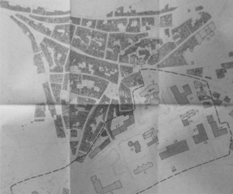
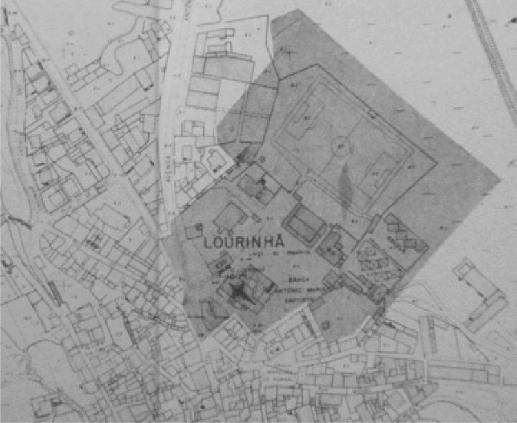
Lourinhã’s map in 1979 with the proposed area for development outlined. The contrast in the two landscapes is clear in terms of topographical layout, size and space. Source: CML, Plano de Pormenor da Zona Central: Extracto do Plano Aprovado, 1979’, Plano Geral de Urbanização da Lourinhã’, 1984. Caixa: Plano Geral de Urbanização da Lourinhã (Arquivo Municipal da Lourinhã, PT).

This left Lourinhã with a stable socio-economic profile that translated into relative political calm. Not since the 1930s, when Salazar's appointed local administrative commission faced complaints of corruption, has the municipality experienced political upheaval that deserved national attention.Footnote 20 Indeed, no major political action either in support of or against any particular government in the twentieth century has occurred in Lourinhã. As a result, the local government has enjoyed stability. The CML's administrative commission, installed during the revolution to replace the dictatorship's appointees, for example, was made up of former dictatorial officials and men who had been accepted participants in political life before 1974. In fact, Lourinhã’s pre-1974 mayor returned to the CML as a councillor in the late 1970s. Further highlighting political stability in Lourinhã, citizens have consistently swept the Socialist Party (PS) to power at all levels since winning the ability to elect their representatives.
The area that would become the new town centre in the 1970s is highlighted here. Dominated by the town's old soccer field, the area included the old farmers' market. Today, the new square, the Praça José Máximo da Costa, is an open area bounded by the medieval convent (in the map above), a courthouse, a fire hall, a post office, a music academy and the new town hall. The renovation of this space was total.
Source: CML, Plano de Pormenor da Zona Central: Extracto do Plano Aprovado, 1979’, Plano Geral de Urbanização da Lourinhã’, 1984. Caixa: Plano Geral de Urbanização da Lourinhã (Arquivo Municipal da Lourinhã, PT).
The fact that little incentive for development is found in the demographic, industrial or political history of Lourinhã makes it an attractive case with which to assess the relative influence of long-term changes in Portugal on local experience. Lourinhã, like, I suspect, many Portuguese towns of similar make-up, becomes a site for enquiry into how processes like local urban plans or political upheaval at the national level can influence local culture at an incremental pace.Footnote 21 Historical change, for the most part, does not occur in extraordinary circumstances. Lourinhã’s experience demonstrates how governments and private actors can work together to drive meaningful change without major rupture or disruption in peoples’ lives.
Scholars have long recognised that the space in which people live and interact is an important site for negotiation over the attainment and maintenance of power. A variety of historians have explored how the shift from the early modern to the modern period reworked people's social, political and cultural experiences by renovating the spaces in which they lived. Urban centres in particular became new sites of social exchange.Footnote 22 Urban development had implications for how governments and citizens interacted. For governments, urban space would need to be organised for supervision and rationalisation as they emerged as venues for political dissent and protest.
Famously, Michel Foucault described how the Western World made organised space an instrument of power between the eighteenth and twentieth centuries in order to discipline society.Footnote 23 As such, governments developed ‘political technologies’ devised to create ‘a governable space of calculability’.Footnote 24 Governments acted in this way to counter citizens who found themselves with new access to arenas of political expression and organisation. Indeed, Jurgen Habermas has argued that the public sphere emerged as an intermediate space for negotiation between rulers and citizens.Footnote 25 Historians such as Pedro Ramos Pinto and Diego Palacios Cerezales have done much to highlight the struggle between increased governmentality and citizen expression in twentieth century Portugal.Footnote 26 Ramos Pinto, for example, has argued that an unintended consequence of Estado Novo policies that prized the family and the home was that Portuguese subjects used these policies to legitimise demands for housing rights from the dictatorship.Footnote 27
In Lourinhã’s development, the construction of its contemporary space demonstrates that both government and citizens were involved in a political project to build ‘European’ – read ‘modern’ – Lourinhã. Certainly, ‘European’ is the most recent label in a process that began in earnest in the 1870s that would reorder Lourinhã’s space and political institutions, and that would come to value well recognised markers of modernity in the West, like efficiency. One local historian points to the administration that emerged in Lourinhã in the wake of the Janeirinha uprising of 1868 (a minor revolt led by merchants protesting new sales taxes). As a result of the turmoil, Lourinhã was granted its own court to deal with their local rebels.Footnote 28 From this sprang the need for a more sophisticated administration, which would be appointed in 1875. Led by this group, Lourinhã began to build its modern landscape by introducing a variety of new municipal services and institutions like roads, sewers, public fountains, a post and telegraph office, a municipal slaughterhouse and public lighting.Footnote 29
By the 1960s the process that followed from Lourinhã’s early development came to emphasise Portugal's association with the Western world and other important aspects of modernity like efficiency in economic activity. Indeed, closer association with the West and efficiency were linked. The discourse that emerged warned locals that a new world was emerging in which Portugal would have to change in order to keep up with its Western neighbours. Education, the use of technology, science and mechanisation in agriculture and increased civic engagement and pride in one's community would help Portugal to achieve a degree of equality with the Western world.Footnote 30
Generally speaking, there exists some agreement amongst scholars that modernity is synonymous with Westernisation, mechanisation, organisation and so on. That said, Susan Friedman illustrates the fluidity of modernity's definition by pointing out that a cultural critic would call it a break with the past, ‘a willed forgetting of tradition, continuity, order’. At the same time, a social scientist would argue that modernity is state planning, totalisation and centralisation, which are synonymous with the Enlightenment's ethos expressed in progress, science, reason and truth.Footnote 31 In this light, it is unsurprising that the modern would come to be labelled as ‘European’ in places like Lourinhã. As Michael David-Fox reminds us, in post-war social science, modernisation became a march towards a Western European and American system.Footnote 32
Although I agree that modernity is a fluid concept, Lourinhã’s experience suggests that fluidity is relegated to the periphery. At its core, modern Lourinhã should be understood as a project in which a centralised and rationalised system emerged as a result of state planning, which valued the standardisation of experiences. However, as can be seen in Lourinhã’s experience over the longue durée, the development of state planning and standardisation in modern Lourinhã was a common goal of successive governments at various levels and of locals who often demanded improved public services from their government.Footnote 33
In order for Lourinhã and Portugal to modernise, it accepted and eventually embraced Western Europe, as association with the continent and its values became synonymous with prosperity. After the Second World War, the Estado Novo made Portugal what Nicolau Andresen-Leitão has called a ‘reluctant European’ in need of western money and markets but suspicious of political and cultural intervention.Footnote 34 Salazar, however, could not prevent Europe's cultural influence. As the economy opened to Europe in the 1960s, Western European ideas made their way to Portugal along with investment and tourists.Footnote 35
The revolution of 25 April 1974 is often celebrated as the moment when Western influence gave birth to Portugal's democratisation, securing modernisation. The dominant trend in the historiography is to celebrate 1974 as a break from dictatorship and a victory for Mário Soares, democratic socialism and parliamentary democracy over Alvaro Cunhal, radical elements of the Armed Forces Movements (MFA) and communist representative democracy.Footnote 36 However, historians have begun to challenge the interpretation of 25 de Abril as a break from the past by considering it in the longue durée.Footnote 37 ‘Evolution, not revolution’ has inspired the reassessment of the revolution's accomplishments as many argue that democratisation and modernisation in Portugal were well underway before 1974.Footnote 38 Similarly, the Estado Novo's influence, as will be suggested, reached long past 1974. Certainly, Lourinhã’s development stands as yet another example of both the long process of modernisation and democratisation and the influence of the Estado Novo in Portugal today.
Long-term economic and infrastructure policies of the Estado Novo go some way in allowing historians to consider the Revolution in historical context. Between 1935 and 1999 the Portuguese government engaged in five major economic plans, four by the Estado Novo and one by the democratic government. Foreign and private investment increased in each plan while money was funnelled to projects that would provide education, roads and electricity to the country.Footnote 39 Indeed, a 1969 survey of Lourinhã’s infrastructure conducted by the CML reveals that there was plenty of room for infrastructure improvement in late 1960s Portugal. Locals were asked to report by neighbourhood on road access, electricity, water treatment facilities, garbage collection and cleaning services. A tally of the survey's results shows that of seventy-eight neighbourhoods in Lourinhã, sixty had road access, forty had some form of electrical service, twenty-five had water treatment infrastructure and seven enjoyed garbage collection or cleaning services. Replies were hand written and respondents added addendums, which show that they felt an additional five neighbourhoods needed road access, three needed electricity, thirteen needed water treatment and thirteen needed cleaning services.Footnote 40 In contrast, by 1991 Portugal's infrastructure had advanced to the point where ninety-six per cent of Lourinhã’s homes had electricity, ninety-three per cent were attached to sewers and ninety per cent had running water,Footnote 41 changing how people experienced their homes and communities.
II
Domestic improvements between the 1960s and 1990s accompanied development in public facilities like Lourinhã’s market hall. By the 1970s Lourinhã’s daily farmers' market, founded in 1933, was a blemish on the town. In fact, the CML considered the market hall ‘deplorable’.Footnote 42 However, the institution's rejuvenation between 1976 and 1989, with its new building, its improved amenities (like electrical infrastructure) and the standardisation of the facility's features, was emblematic of the town's change. By way of introduction, the market hall's roof, amongst other things, had fallen into disrepair in the 1970s. This sent the CML on a search for a replacement that could transmit light, reflecting the fact that electrical infrastructure was insufficient to provide enough artificial lighting for the facility.Footnote 43 In fact, in many ways, electrical service was at the heart of the renovation of Lourinhã’s market hall, the town's landscape and how residents experienced it.
In 1987 Lourinhã’s Mayor, José Manuel Dias Custódio, announced that all residential and commercial areas were finally on the electrical service network.Footnote 44 The completion of the electrification of Lourinhã was a large step in the town's modernisation and the transformative power of electricity was not lost on the planners of Lourinhã’s new market hall. 1982’s architectural proposal, the one that was eventually accepted and built by the town, cited a number of international standards in various aspects of market hall design, such as vendor site dimensions and the types of material used, along with its quality and strength. It also declared that electricity was a necessary aspect of new market halls. Electricity, the proposal argued, would help shape the consumer's experience, offering services that shoppers would find in Portugal's other ‘modern market halls that had been built’ in Lisbon, Cascais and Loures.Footnote 45 Electricity would light the exterior and the interior of the building, including the shops and stall area. Furthermore, emergency exits required lighting while the insect lights – needed for hygienic purposes – also required voltage. Finally, infrastructure, including the clock, the sound system and public telephones, needed to plug-in.Footnote 46 Planners linked these services to modern retail facilities stating that market halls needed ‘good illumination to make things look clean and attractive’, as well as electric cash registers and illuminated signs to exhibit the prices of products.Footnote 47 Electricity would also facilitate proper exposition of everything from farmers’ products to luxury items.Footnote 48 Moreover, certain areas, including the municipal, veterinary and market hall administrator's offices required electrical heating for their workplaces.Footnote 49
Electricity would also have an impact on the area surrounding the market hall. As late as 1984, the project's planners sought to use Lourinhã’s new market building as a starting point to develop the east end of the town. With a planned electrical substation in the new facility, Lourinhã would be able to spread its electrical net to new neighbourhoods. This would allow future residents to bring lights, telephones and refrigerators to their homes.Footnote 50 Electricity from the market hall's substation would also power traffic lights and street lamps in the immediate neighbourhood.Footnote 51 This initiative helped to ensure that, by 1993, per capita energy consumption in Lourinhã matched that in Lisbon and the Tagus Valley.Footnote 52
Private individuals followed suit and prized electricity as an important part of their landscape. In the 1970s residents petitioned local officials, asking that their neighbourhoods be next to receive public electrical lighting for a variety of reasons. From a sample of thirty-eight letters sent by residents, individually and in groups, to the CML between 1970 and 1977, the value placed on electrical infrastructure in the urban environment is clear. Sixteen of these letters offered the CML financial help or offered to provide some of the labour needed to install the requested service. Seventeen were from groups of community residents, and eight included hand-drawn diagrams of the neighbourhood, demonstrating the requested placement of new infrastructure.Footnote 53 In other words, electrical lighting was not simply a service to be provided, instead it was something to be sought out and worked for.
Like in the case of the market hall, electricity would, in the minds of letter writers, help them to navigate their environment. Some, like Henrique dos Santos and Heitor dos Reis, explained that public electric lighting would help them overcome the poor condition of the road at the entrance to their neighbourhood in Atalaia de Baixo – ‘especially during the winter’.Footnote 54 Others linked electric infrastructure to the safety of the town and its residents. António Rodrigues Antunes da Silva's corner-store in Ventosa served many farmers who ‘did not return from work until night time’ to buy their bread and other goods and thus needed public lighting to navigate the dark and avoid danger. Further, since it was occasionally children who were sent to buy bread from the store, ‘it was absolutely necessary’ to have the street lit.Footnote 55 Similarly, a common explanation for the need for electrical lighting was so that residents could overcome the darkness, which ‘occasionally turns everything to disorder’.Footnote 56
In fact, ordering surroundings with electrical lighting was also an important point of inclusion for residents in the 1970s as some letter writers adopted a democratic discourse arguing that they had a right to the service. An August 1971 letter from residents of an apartment building on rua Miguel Bombarda in Lourinhã complained that as the area around the building gained electrical lighting, their building had been left in the dark. ‘Inexplicably’, their building was left without public lighting, an asset deemed ‘indispensible’. The letter concluded not by asking for a lamp but instead by asking if their building had been inadvertently over-looked.Footnote 57
Similarly, Silvério Santos’ October 1974 request for a street-lamp in Casal do Seixo leaves the impression that residents increasingly saw lighting as a basic right – especially when one considered that some had it and others did not. Santos explained that close to three hundred metres of road remained unlit outside his home and that people had to ‘pass that distance at night without a single light’. Santos called the situation ‘inhuman’ and complained that raising the necessary money could only be done ‘with difficulty!’ by local residents. Santos continued by insisting that his request was ‘so simple’ and ‘just’.Footnote 58 Some residents even questioned post-revolutionary Portugal's priorities when it could not deliver electrical infrastructure. António Ilídio Martins João of Casais Novos in Moita dos Ferrieios asked why Portugal was ‘on the road to [social democracy] if there could not be a society where he could ask for a lamp or lantern’ for his neighbourhood. João was expressing his frustration after having waited two months for a follow up letter that was promised to him in a face-to-face conversation with the mayor, in which he had asked for lighting and offered to help with the costs.Footnote 59
If locals were in favour of ordering their domestic environment, this was all the better for the market hall planners, who felt that mobilising electrical services, designating retail spaces and creating new regulations were part of a broader effort to develop a more standardised, modern public space. 1978’s plan for the market suggested that the common area in the building, where vendors used stalls to sell their goods, should be limited in order to facilitate space for more permanent stores inside the building. This would allow room for street vendors to move into the facility and under the eye of the market hall's manager, whose office was to be placed on the second floor overlooking the facility.Footnote 60
In addition, market hall planners and town officials arranged the facility's interior in an on-going attempt to streamline consumer experience. Planners organised vendor space, emphasising certain products, aesthetics, hygiene and customer comfort. In the proposal settled upon in the early 1980s, a quarter of the stalls were designated for fish, while the rest were to be split between fresh fruit and vegetables, with a minority of stalls reserved for horticultural products.Footnote 61 In order to make the market hall more appealing, the floral vendors were to be at the entrance, whereas fishmongers would occupy the stalls in the corner furthest from the main door.Footnote 62 This was done for aesthetics and hygiene. As first mandated in 1983, six years before the new facility was ready, the CML limited the sale of all salted and fresh fish to a specified zone in the existing market hall, with the preparation of the fish for sale not to occur on the retail grounds.Footnote 63 Moreover, consumers would be spared having to avoid animals that had, before 1983, been allowed to enter the market hall to deliver goods.Footnote 64 Finally, all surfaces were to be tile or stainless steel, and the hall was to be equipped with bug-lamps on the periphery in order to maintain the highest hygienic standards possible.Footnote 65 These regulations established, for the first time, a standard fee for the rental of retail stalls, rules for lease transfers and a schedule of lease payments on the stalls. In addition, a penalty system was put in place that saw violators of the regulations receive gradually more severe penalties, including fines and suspension leading to eventual expulsion.Footnote 66
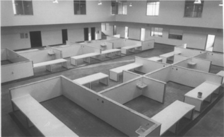
For the CML, the development of the market hall proved to be a fluid process, due in part to influence from the regional government on the project. As had been the case under the dictatorship, democratic municipal governments remained beholden to their regional and national colleagues.Footnote 67 Indeed, the evolution of the CML's plans for the market hall was influenced by feedback from the District of Lisbon. 1978’s proposal called for a vast facility with sixty-five stalls and twenty permanent and self-contained stores. However, the District of Lisbon cautioned that this was ambitious, suggesting that the number of stores be dropped to ten and that stalls be removed without affecting space for fish, eggs, turkey and chicken.Footnote 68 As the following figures demonstrate, the contrast between initial market hall proposals and the final product is drastic. From an original plan for sixty-five stalls and twenty stores in a circular building, plans for the market hall dwindled, coming to settle upon a facility with twenty stalls and a handful of stores in a mundane, rectangular layout.
III
In addition to pressure from higher governmental institutions when planning their landscape, the CML was also facing on-going local efforts to influence the landscape. Beginning in the years leading up to the Revolution and lasting well into the 1990s, the CML was becoming increasingly concerned with what they termed obras clandestinos, or clandestine works that did not adhere to Lourinhã’s management of the landscape. These ranged from unauthorised additions to existing buildings, to the building of weekend huts along the coast and, most notoriously, to small shantytowns that were built in the 1980s by former African colonials who immigrated to the metropole. Demolished in the late 1980s, the African buildings are by far the least documented instance of the obras clandestinos as the local paper – very much an establishment organ – offered no coverage. Further, no documentation was kept in Lourinhã’s municipal archives beyond demolition notices, which, as the archives fell into mismanagement in the early 1980s, are difficult to find after 1981 or 1982.Footnote 69 In such cases, clandestine works were associated with poverty and, like their owners, those outside the mainstream. As early as 1970, the local newspaper, the Alvorada, reported on the campaign to eliminate the ‘[in]famous huts’ by the municipal government in Lisbon. The problem with clandestine works was that they were ‘huts and other installations that did not offer security, hygiene, a salubrious’ environment’ and were what the people called ‘biddonvilles’ (bairros de lata). These places were the result of poverty and unemployment, the Alvorada explained, and were, sadly, a feature of many urban centres.Footnote 70
The original 1978 proposal called for a sprawling, circular design that would include an overwhelming sixty-five stalls and twenty permanent stores.
Source: Serviços do Fomento, ‘Planta: Mercado Municipal da Lourinhã (Ante-Projecto)’, ‘Câmara da Lourinha, Mercado: Ante-Projecto’, (June 13, 1978). Obras Municipais, Box 56, proc. P37-H/22 (Arquivo Municipal da Lourinhã, PT).
The municipal market shortly before opening in 1989 shows a much more modest and simple plan that, instead of housing some sixty-five stalls and twenty stores, offered twenty stalls and a handful of permanent stores. Today the permanent stores are butchers’, cafés and restaurants.
Source: ‘Mercado Municipal, 1989’, General Photo Collection, (Arquivo Municipal da Lourinhã, PT).
However, instances of crackdown on clandestine builds in Lourinhã were more commonly related to illegal builds undertaken by non-shantytown citizens. Residents like Pedro Teodoro dos Anjos of Santa Barbara faced an increasingly coordinated administration that was intolerant of illegal construction. When Anjos, for example, went ahead and built an addition onto his house that exceeded his permit in 1974, the CML investigated and decided that the illegal portion of the new build would have to be demolished, as per various laws and regulations under the General Regulation of Urban Buildings (Regulamento Geral dos Edificações Urbanos).Footnote 71 Others, like Joaquim da Costa of São Bartolomeu, faced fines if they did not demolish their clandestine works. Having built a wall around the first floor of his home without a permit from the CML, Costa was warned in October 1974 that if the offending wall were not demolished within three months, he faced a fine of 10,000 to 50,000 escudos.Footnote 72
By the late 1970s the CML was using the National Republican Guard (Guarda Nacional Republicana, hereafter: GNR) to help control clandestine works. In 1978 the GNR, via the Ministry of Internal Administration, informed the CML that it had warned several residents about their illegal builds.Footnote 73 Indeed, the CML, in its efforts to clamp down on clandestine works in the 1970s, turned to other organisations for help. From the mayor of Cascais, the CML was sent correspondence between Cascais and the Ministry of Urban Habitation and Construction about that municipality's own problems with illegal builds. As the mayor of Cascais explained, they lacked the ability to properly regulate the situation and the national ministry was able to help.
In their case, Cascais faced a number of problems including those clandestine works that, although illegal, were in fact beneficial to local residents. As the mayor explained, in Cascais, many illegal buildings existed that locals rented to tourists and residents, benefitting owners, but remaining outside of municipal control. In such cases, demolition was not ideal for either the local municipal government or the owner. Put simply, the local administration was more interested in bringing offending builds under taxable control.Footnote 74 When not controllable, clandestine works like José da Costa's were slated for demolition. Having built a ‘wooden tent’ (barraca da madeira) at Paimogo, Costa, who owned a home in Seixal and used the hut to relax at the beach, was ordered on 15 July 1980 to demolish it within eight days. Referred to as the ‘transgressor’ in correspondence, Costa had failed to demolish his hut as late as 6 August. The port captain at Paimogo asked the CML to demolish the hut and charge Costa for all costs.Footnote 75
Clandestine and unsanctioned works flew in the face of the remodelling that Lourinhã was undertaking in the 1980s. As part of the market hall project, Lourinhã would move its administrative and cultural centre away from the old town by building a new, vibrant and spacious square (Praça). When planned in 1982, the market hall was to be situated alongside a new bus terminal, municipal offices that would eventually become the new town hall, a garden and a music school.Footnote 76 The market hall's site on a new town square would benefit from its proximity to the bus station and the site for a monthly flea market (Campo da Feira) and would be easily accessible by the public with a new traffic circle, a parking area and parking spaces on the new town square.Footnote 77 In addition, the size, coupled with the new square's proximity to the main road that passed by the market hall, made it more accessible to automotive and bus travellers than the old centre. Further, it was assumed that the new square would attract business to Lourinhã. The market hall proposal from 1978, in fact, suggested ten self-contained stores, separate from the stalls, instead of the twenty that Lourinhã’s representatives had originally requested. The planners’ assumption was that the market hall would entice entrepreneurs to establish stores in the area and reducing the number of stores in the market building would encourage development by would-be store owners in the area.Footnote 78
‘Fair prices for farmers’. Although little resistance to Lourinhã’s renovation is evident (in fact, locals played an active role in building the town's modern landscape), public space remains a site for protest. The above graffiti, appearing outside Lourinhã’s modern market hall in the wake of the financial crisis of the late 2000s, remains there today.
Source: ‘Market Graffiti’ (collection of the author, 2010).
‘Supermarkets eat everything’.
Source: ‘Market Graffiti’ (collection of the author, 2010).
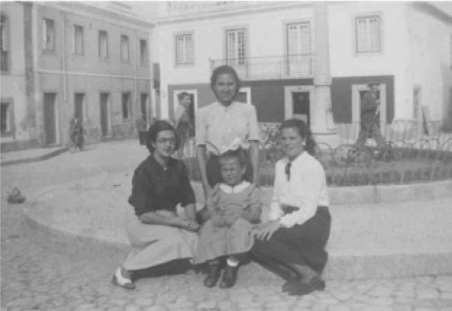
The Praça Marques Pombal, c. 1940. The old square was a cramped parking lot by the time the new one opened in the 1990s.
Source: Collection of Maria Isabel Mendes.
The commercial importance of the new town square was evident in the 1966 plans for a new town centre as well. In 1966, an early proposal for the centre of Lourinhã was approved. It proposed that the new centre of Lourinhã would include a bus station, market hall, cinema, schools, a post office, a courthouse, a new town hall and the farmer's guild (Grémio da Lavoura).Footnote 79 With little movement in the intervening years beyond the opening of a post-office in 1966 and a courthouse in 1980, Lourinhã’s new town centre was still under consideration in the mid 1980s. In 1984, many of the CML's public services were still offered and administered from the town hall on the Praça Marques de Pombal. However, even at this early stage (seventeen years before the new town hall would open), the CML was insisting that these services would need to move to a new town centre on the then called Praça da Républica (to be renamed the Praça José Máximo da Costa for Lourinhã’s first elected post-revolutionary mayor). This area was targeted as the site for a new civic centre for the town where the town hall would eventually be situated.Footnote 80 The old town, being ‘compact [and with] low buildings’, was in ‘strong contrast’ to the areas of recent urban expansion – in part a model for future development – where apartment blocks towered over the old town.Footnote 81
By this time, the goal for the new town centre was to create a large, central space that could accommodate several buildings to house services. The area, it was hoped, would become a meeting space for locals. Thus, it had to include leisure spots (today a café and a amphitheatre are found in the square), be easily accessible and include trees and other green infrastructure.Footnote 82 In 1984 the CML published a ‘General Plan for the Urbanisation of Lourinhã’. Along with the District of Lisbon, the CML felt the need to establish an ‘instrument that would provide the best possible development of urban space in order to achieve equal development’.Footnote 83
José Máximo da Costa, c. 2008. The new square is open and airy.
Source: Collection of the author.
Indeed, in 1984 Lourinhã published an urbanisation plan that would see 1966’s goals largely achieved. The 1984 urbanisation plan explained that since the early 1970s Lourinhã had expanded towards Torres Vedras, primarily in the Quinta Santa Catarina Zone where new facilities would ‘dynamise’ (dinamizar) the social and cultural life of the town and promote future urban growth’.Footnote 84 A result of ‘clearly expressed necessities’, the plan had a number of overarching goals. The plan was: to promote the on-going study of the urban environment in order to detect and resolve issues before they affected the town; to bring together smaller and diverse plans into one general urbanisation plan; to eliminate gaps in urban development, which led, perhaps, to the aforementioned illegal buildings; to mobilise all available mechanisms in support of Lourinhã’s urbanisation; to establish a schedule for periodic revisions and the maintenance of the plan; and to inform the public while promoting their participation and getting their input in urbanisation's objectives. These goals went hand-in-hand with the desire to increase Lourinhã’s population by almost 1000 people by 2004, create jobs across the primary, secondary and tertiary sectors in the town, improve the quality of the town's housing, expand the town's industry without polluting the environment and improve town services like transportation via road improvement.Footnote 85
Road and transit management was a key aspect of the organisation of space in the years following the 1984 plan. Transit was one of the CML's major concerns in the 1980s as the ease of movement of people and goods was vital. Their urbanisation plan, for example, discussed the need to balance accessibility to the urban environment between pedestrians, cars, commercial vehicles and transport animals while maintaining trees and green infrastructure.Footnote 86 Already in 1980, Lourinhã’s plans had to be revised to accommodate a new road, bypassing the centre of the old town and linking Lisbon, Lourinhã and Peniche. The new road would pass near to the Campo da Feira, the soccer field, a school, a day care centre, the ‘future Câmara Municipal’, the bus station, the market hall, the health centre, the old age home and a town parking lot.Footnote 87 This was a convenient development for the CML, who recognised that traffic had to be diverted away from the old town centre. The first proposal undertaken after 1984’s urbanisation plan was 1985’s plan to expand Lourinhã’s bus terminal along the new road and into the outskirts of the town, keeping heavy bus traffic outside of Lourinhã’s cramped streets.Footnote 88
Two zones in Lourinhã proper became foci of space management after traffic had been pushed to the outskirts. These were the old main road (Rua João Luis de Moura) through the historic centre of town and the area that would become the new main square. The new town square was to be a mixed-use space with an open-air amphitheatre that could sit 226 people. Surrounding the amphitheatre would be a bar with a patio and flowerbeds. The space would also include trees.Footnote 89 Along with the new town hall, the square included 1980’s courthouse, 1966’s post office, the fire hall, a music academy and the seventeenth-century convent that was converted to a multiuse facility housing a day care, as well as the Alvorada’s offices, a popular, if run down, café and the town's main church. At the same time that the CML was moving to complete its new square, it was also preparing to turn Rua João Luis de Moura into a pedestrian mall – a project made possible by the Lisbon–Lourinhã–Peniche bypass.Footnote 90 Previously the only road through Lourinhã from Lisbon or Torres Vedras to Peniche, Rua J.L. de Moura was transformed into a commercial zone limited to pedestrians, with cafes and restaurants, stores and local galleries, as well as the town's museum and library.
Rua João Luis da Moura has become a pedestrian mall. However, it was the only throughway for traffic between the factories and fishing port of Peniche and urban areas to the south, including Lisbon.
Source: Câmara Municipal da Lourinhã, ‘Appendix: Arranjo Urbanístico da Rua João Luis de Moura’, 15 October 1997. Caixa: Plano Geral de Urbanização da Lourinhã (Arquivo Municipal da Lourinhã, PT).
IV
The development of Lourinhã’s market hall and new town centre was done without the private involvement that we see in the town's electrification. Indeed, Lourinhã’s municipal archives are lacking the petitions and letters that we find when exploring files on electrification. One explanation is that neither the archives nor the municipal government of the 1980s recorded such interventions. Another is that complaints were not made. This, however, does not stand up to the scrutiny of logic: residents were not shy to lobby on a variety of infrastructure issues, if they had concerns about public institutions it is reasonable to assume that they would have voiced their concerns.
A more likely explanation for the absence of direct intervention is that citizens were eager to engage in issues surrounding domestic living, but when arms-length public development was at stake, they proved less enthusiastic. This supports the conclusions of the aforementioned Ramos Pinto and others who suggest that domestic issues provided individuals with unique motivation and opportunity to engage with authority.Footnote 91 Yet another explanation for apathy is the way in which projects like the market hall were developed – in backrooms and at government levels out of public view. Although such activity can cause public outrage, it often, as we see in many contemporary examples, inspires disenchantment in government and its processes.
The adjudication of bids to build the market hall, not recorded in the CML's minutes, leaves one wondering about how the decision was made. From an open competition in which fifteen construction companies submitted proposals, a local company was chosen.Footnote 92 This company, one competitor complained, who coincidentally submitted the lowest cost bid, was chosen despite failing to provide a building plan or schedule with expenses and materials.Footnote 93 As construction progressed, the local company, which had done work for the CML in the past, presented a variety of problems ranging from demands for more money from the CML to sub-contractors approaching the town council for payment owed them by the contractor.Footnote 94 In a world where such irregularities were common – Martin Kayman described 1980s Portugal as a place where ‘a word in the right ear’ still mattered – perhaps it is no surprise that locals avoided projects that did not directly affect them.Footnote 95
Participation patterns highlight the fact that the CML remained the most important actor in the redevelopment of Lourinhã since the 1960s. Certainly, the municipal government was an important contributor to the discourse that emerged around development and the goals that were set for the landscape. When one considers the limitations on municipal governments in Portugal in the last fifty years, it is remarkable how influential the CML was in Lourinhã’s development. The Estado Novo eliminated local autonomy by making local governments and their agents appointees of the central government. This began to change after 1974 as municipal officials became elected – the first elections were held in 1977 – and municipalities were given some financial autonomy in 1979.Footnote 96 Nevertheless, scholars like Walter Opello conclude that given municipalities were dependent on the national and regional governments for upwards of sixty-five per cent of their funding into the early 1980s, local officials remained representatives of Lisbon in practice.Footnote 97 However, when we consider specific program examples like Lourinhã’s urban development, the supposedly impotent municipal political sphere can appear lively, influential and as worthy of examination as major cities in Portugal and Europe.
Undeniably, when considering how to assess the relative influence of long-term processes on a society, the municipal level emerges as a fruitful site of enquiry, revealing how local institutions can serve to cushion the effects of rupture at national levels. Thanks, in part, to the way the CML was able to guide urban development and local participation in Lourinhã’s modernisation, the reshaping of public space, as seen in both the market hall and the new town centre, was relatively easy, enjoying tolerance, if not support, from citizens. This is no small thing, especially when one considers contemporary and on-going battles over public space in Turkey's Taksim Square in the summer of 2013 or in Brazil's cities, as that country navigates the fall out from the 2014 FIFA World Cup and prepares for the 2016 Summer Olympics, for example. In those cases contrasting views on the use of space emerged, with government forces on one side and local civil agents on the other. In Lourinhã, the long process of urbanisation, periodised here between 1966 and the early 2000s, helped to wash over potential points of agitation. With many of the major developments coming to fruition in the democratic period, Portuguese citizens in Lourinhã tacitly accepted the accomplishment of the dictatorship's urban goals as achievements of modern, democratic and European Lourinhã. Indeed, the transition from dictatorship to democracy was so smooth that citizens of Lourinhã in the 1980s did not consider goals first mentioned in 1966 as dictatorial.