Introduction
14C occurs naturally in the Earth’s upper atmosphere, where it rapidly oxidizes to 14CO2 and enters the global carbon cycle. Under pre-industrial steady-state conditions, the atmospheric 14C/12C ratio fluctuated within relatively narrow natural boundaries controlled primarily by variations in cosmic ray intensity modulated by solar activity and geomagnetic field strength (Reimer et al. Reference Reimer, Austin, Bard, Bayliss, Blackwell, Bronk Ramsey, Butzin, Cheng, Edwards, Friedrich, Grootes, Guilderson, Hajdas, Heaton, Hogg, Hughen, Kromer, Manning, Muscheler, Palmer, Pearson, Van Der Plicht, Reimer, Richards, Scott, Southon, Turney, Wacker, Adolphi, Büntgen, Capano, Fahrni, Fogtmann-Schulz, Friedrich, Köhler, Kudsk, Miyake, Olsen, Reinig, Sakamoto and Sookdeo Aand Talamo2020; Stuiver and Quay Reference Stuiver and Quay1980)
This equilibrium was disrupted during the 20th century by the fossil fuel production during industrialization and by the large-scale atmospheric testing of thermonuclear weapons. Between 1955 and 1963, approximately 600–700 Mt of fission products injected an estimated 1028 atoms of 14C directly into the stratosphere and the troposphere (Turnbull et al. Reference Turnbull, Graven, Krakauer, Schuur, Druffel and Trumbore2016). This caused a near-doubling of 14C/12C ratio of the atmospheric 14CO2 reaching a peak (so-called “the bomb peak”) in 1963 (Naegler and Levin Reference Naegler and Levin2006). Nearly all tests were conducted above ground or in the lower atmosphere before the 1963 Partial Test Ban Treaty. The artificially produced 14C mixed rapidly into the stratosphere and the troposphere and has been taken up by the biosphere and the ocean.
Regarding radiocarbon dating, it is important to know the spatial distribution of 14C for developing of accurate calibration curves. Hua and Barbetti (Reference Hua and Barbetti2004) defined a special distribution of 14C, NH (Northern Hemisphere) and SH (Southern Hemisphere), for a better understanding of the carbon cycle and accurate 14C dating. The difference in spatial distribution of 14C is especially pronounced within the bomb peak period and therefore, three zones are defined for the Northern hemisphere and two zones for the Southern hemisphere. The 14C/12C ratio is the highest in the NH1 and the lowest in the SH1-2 zone (Hua et al. Reference Hua, Barbetti and Rakowski2013, Reference Hua, Turnbull, Santos, Rakowski, Ancapichún, De Pol-Holz, Hammer, Lehman, Levin, Miller, Palmer and Turney2022). Depending on the location of the sample to be radiocarbon dated, the selection of the proper zone for calibration of results is essential for obtaining reliable results. Calibration curves for the bomb peak period are included in calibration programs such as Oxcal (Bronk Ramsey Reference Bronk Ramsey1995) or CaliBomb (Reimer et al. Reference Reimer, Brown and Reimer2004) and can be easily selected. The problem may occur if the sampling area lies on the boundary of two zones, as is the case in Croatia. Croatia is situated between 42°23′ and 46°33′ N and 13°30′ and 19°27′ E. Due to its position within the boundary between NH1 and NH2 zones, the calibration of radiocarbon results for samples from the bomb peak period could raise an issue regarding the choice between zones, i.e., calibration curves. To resolve this issue, radiocarbon analyses of tree rings from wood from two main locations in Croatia were performed and compared to the NH1 and NH2 zones (Hua et al. Reference Hua, Turnbull, Santos, Rakowski, Ancapichún, De Pol-Holz, Hammer, Lehman, Levin, Miller, Palmer and Turney2022).
Methods
Sampling locations
Trees were collected from multiple locations (Figure 1). Within the city of Zagreb, a region exposed to fossil fuel exploitation/emissions, trees were sampled from three different locations, one tree per location. The main location was IRB (abbreviation for the Ruđer Bošković Institute, 45°49′46.88′′N, 15°59′14.54′′E, altitude 186 m), while the other two, Tijardovićeva street (45°47′42.52′′N, 15°54′7.02′′E, altitude 118 m) and V. Njegovana street (45°47′24.10′′ N, 15°56′52.42′′E, altitude 115 m), were used for comparison. The two locations are expected to have even more fossil fuel exposure than IRB because they are in more populated areas of the city. The other main location, Crna Mlaka (45°34′29.65′′N, 15°46′14.17′′E, altitude 110 m) is considered to be a location without local fossil fuel influence. It is located inside the bird sanctuary Crna Mlaka. The approximate distance between the main locations Crna Mlaka and Zagreb is 30 km. All locations are characterized by the Cfa climate type, moderately warm and humid with hot summers (Beck et al. Reference Beck, Zimmermann, McVicar, Vergopolan, Berg and Wood2018; Peel et al. Reference Peel, Finlyanson and McMahon2007) with prevailing N and NE winds (Likso and Panžić Reference Likso and Panžić2012; Lisac Reference Lisac1984; Zaninović et al. Reference Zaninović, Gajić-Čapka, Perčec Tadić, Vučetić, Milković, Bajić, Cindrić, Cvitan, Katušin, Kaučić, Likso, Lončar, Lončar, Mihajlović, Pandžić, Patarčić, Srnec and Vučetić2008).
Locations of sampling sites. The main map shows the city of Zagreb and location Crna Mlaka. Three sublocation are shown detailed in the lower left map and the position of Croatia in Europe is presented in the bottom right corner.

Sampling, sample preparation and measuring technique
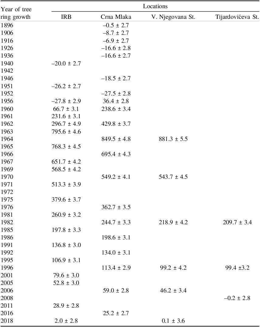
All sampled trees were deciduous species with growing period spring/summer: Quercus robur from Crna Mlaka location, and Gymnodadus dioicus, Acer spp. and Sophora japonica from IRB, V. Njegovana and Tijardovićeva St. locations, respectively. The year of the tree’s death was known and it was attributed to the year of the last tree ring (Table 1).
Δ14C analyses of tree rings from the investigated locations.

Table 1. Long description
A table comparing delta 14C analyses of tree rings from various locations over different years. The table has 4 columns and 30 rows. Column headers are Year of tree ring growth, IRB, Crna Mlaka, V. Njegovana St., and Tijardovićeva St. Row 1: 1896,-0.5 ± 2.7, Row 2: 1906,-8.7 ± 2.7, Row 3: 1916,-6.9 ± 2.7, Row 4: 1926,-16.6 ± 2.8, Row 5: 1936,-16.6 ± 2.7, Row 6: 1940, -20.0 ± 2.7, Row 7: 1942, Row 8: 1946,-18.5 ± 2.7, Row 9: 1951, -26.2 ± 2.7, Row 10: 1952,-27.5 ± 2.8, Row 11: 1956, -27.8 ± 2.9, 36.4 ± 2.8, Row 12: 1960, 66.7 ± 3.1, 238.6 ± 3.4, Row 13: 1961, 231.6 ± 3.1, Row 14: 1962, 296.7 ± 4.9, 429.8 ± 3.7, Row 15: 1963, 795.6 ± 4.6, Row 16: 1964,849.5 ± 4.8, 881.3 ± 5.5. Row 17: 1965, 768.3 ± 4.5, Row 18: 1966,695.4 ± 4.3, Row 19: 1967, 651.7 ± 4.2, Row 20: 1969, 568.5 ± 4.2, Row 21: 1970,549.2 ± 4.1, 543.7 ± 4.5. Row 22: 1971, 513.3 ± 3.9, Row 23: 1972, Row 24: 1975, 379.6 ± 3.7, Row 25: 1976,362.7 ± 3.5, Row 26: 1981, 260.9 ± 3.2, Row 27: 1982, 244.7 ± 3.3, 218.9 ± 4.2, 209.7 ± 3.4. Row 28: 1985, 197.8 ± 3.3, Row 29: 1986,198.6 ± 3.1, Row 30: 1991, 136.8 ± 3.0, Row 31: 1992,134.0 ± 3.1, Row 32: 1995, 106.9 ± 3.1, Row 33: 1996, 113.4 ± 2.9, 99.2 ± 4.2, 99.4 ± 3.2. Row 34: 2001, 79.6 ± 3.0, Row 35: 2005, 52.8 ± 3.0, Row 36: 2006,59.0 ± 2.8, 46.2 ± 3.4, Row 37: 2008,-0.2 ± 2.8. Row 38: 2011, 28.9 ± 2.8, Row 39: 2016,25.2 ± 2.7, Row 40: 2018, 2.0 ± 2.8,0.1 ± 3.6.
A wood slice (cross section) of approximately 5 cm thickness of each sampled wood was cut. The tree ring analysis was conducted at the Laboratory of Dendrochronology and Forest Resources Inventory, Faculty of Forestry and Wood Technology. To enhance the visibility of the tree rings, the analyzed segment of the tree disc was sanded using a belt sander with various grit sizes. Tree-ring widths were measured using the TSAP-Win software suite for tree-ring measurement and analysis, coupled with a Lintab 6 measuring table and a Leica M50 stereomicroscope. Tree rings were counted, referring to the year of the last tree ring (Rede et al. Reference Rede, Essert, Kocijan and Dubravac2022; Sinković et al. Reference Sinković, Govorčin, Dubravac, Roth and Sedlar2009) and samples for analysis were taken within straight line of the cross section ranging from the middle to the outer layer of wood. A sterile drill was used to take a sample of a particular tree ring, ranging from 50–300 mg of sampled material, taking care that only targeted ring is sampled. The drills used were 3 mm in diameter. The tree rings ranged from 3 mm to 8 mm (approximately). Whenever the tree ring was wider than the drill, drilling was made in the middle of the tree ring.
One sample per tree ring was analyzed. This unprocessed wood raw material was then subjected to chemical treatment. During the chemical treatment alpha-cellulose was extracted to obtain representative 14C activity signal from an individual tree ring (Hoper et al. Reference Hoper, McCormac, Hogg, Higham and Head1998). Soluble organic compounds (e.g., resins and oils) were first removed using solvents (soaking in ethanol: chloroform, 1:2 at 60 °C, for 40 minutes, decanting and repeat three times, followed by soaking sample in 96 % ethanol at 70 °C for 40 minutes, repeat three times and ultrapure water rinse three times). Solvents treatment was followed by bleaching with 1.5% sodium hypochlorite to oxidize and remove resins, lignin, and other mobile wood fractions, that can potentially migrate from adjacent tree rings and contaminate the sampled ring with 14C originating from other years (Cain and Suess Reference Cain and Suess1976; Southon and Magana Reference Southon and Magana2010; Stuiver and Quay Reference Stuiver and Quay1981). Finally, the standard ABA (acid–base–acid) procedure was applied to remove any residual acids and other contaminants. Dried samples were combusted and the CO2 obtained was converted to graphite by zinc reduction (Krajcar Bronić et al. Reference Krajcar Bronić, Horvatinčić, Sironić, Obelić, Barešić and Felja2010; Sironić et al. Reference Sironić, Krajcar Bronić, Horvatinčić, Barešić, Obelić and Felja2013).
Totally of twenty tree ring samples were analyzed at the two main locations, IRB and Crna Mlaka, covering the time span 1940–2018 and 1896–2016, respectively. A total of three samples were analyzed from Tijardovićeva street and six samples from V. Njegovana street and the time periods covered were 1982–2008 and 1964–2018, respectively.
14C/13C ratio of the graphite samples were measured by accelerator mass spectrometry (AMS) at the Center for Applied Isotope Studies, University of Georgia (Cherkinsky et al. Reference Cherkinsky, Culp, Dvoracek and Noakes2010). Additionally, an aliquot of CO2 from each sample was sealed in a glass tube for the determination of δ13C value with an isotope ratio mass spectrometer (IRMS) at the same institution. The 14C values are expressed to AD 1950 according to the radiocarbon convention as Δ14C (‰) quantity, which is isotope fractionation normalised value (δ13C to –25‰) and age-corrected deviation from the standard pre-industrial content of 14C (Δ14C = 0‰) (Mook and van der Plicht Reference Mook and van der Plicht1999; van der Plicht and Hogg Reference van der Plicht and Hogg2006), so they can directly be compared to Δ14C in Hua et al. (Reference Hua, Turnbull, Santos, Rakowski, Ancapichún, De Pol-Holz, Hammer, Lehman, Levin, Miller, Palmer and Turney2022). Δ14C is the Δ term of Stuiver and Pollach (Reference Stuiver and Pollach1977).
Results and discussion
The obtained results were compared with those of Hua et al. (Reference Hua, Turnbull, Santos, Rakowski, Ancapichún, De Pol-Holz, Hammer, Lehman, Levin, Miller, Palmer and Turney2022) and can be seen in Figure 2 and Table 1 (measurement results of analyzed data). The results are in good agreement with the curves for NH1 and NH2 (Hua et al. Reference Hua, Turnbull, Santos, Rakowski, Ancapichún, De Pol-Holz, Hammer, Lehman, Levin, Miller, Palmer and Turney2022).
Δ14C values in tree rings from the studied locations compared to the NH1 and NH2 zones (Hua et al. Reference Hua, Turnbull, Santos, Rakowski, Ancapichún, De Pol-Holz, Hammer, Lehman, Levin, Miller, Palmer and Turney2022).

The Δ14C measurements from the site Crna Mlaka cover the longest time span, from 1896 to 2016, and thus encompass the period when only anthropogenic influence on 14C composition of atmospheric CO2 was the Suess effect (Tans et al. Reference Tans, De Jong and Mook1979), all the way after the bomb peak. In the Crna Mlaka results, a decline in Δ14C levels before the bomb onset is clearly observed, a large increase during the era of nuclear weapons testing and a quasi-exponential decrease starting around 1964, similar to data from Hua et al. (Reference Hua, Turnbull, Santos, Rakowski, Ancapichún, De Pol-Holz, Hammer, Lehman, Levin, Miller, Palmer and Turney2022). The drop in Δ14C before the bomb peak indicates that even locations that are not locally exposed to fossil-fuel sources are affected by the global influence of fossil-fuel CO2 and that this global signal is superimposed on any local effects.
The results from the IRB location, a site exposed to fossil-fuel influence, also display all the key features (the Suess effect, sharp increase, quasi-exponential decline). At location IRB, however, we observe a delayed rise in Δ14C that begins after 1956, later than at Crna Mlaka and the reference results for the NH1 and NH2 zones (Hua et al. Reference Hua, Turnbull, Santos, Rakowski, Ancapichún, De Pol-Holz, Hammer, Lehman, Levin, Miller, Palmer and Turney2022). Δ14C from 1963 to 1985 fit well to the both reference curves and Crna Mlaka location. From 1985 Δ14C values at IRB location shows decline which can be explained by increasing urbanization at IRB location and fossil fuel 14C dilution. The delayed rise is somewhat harder to explain. One possible contribution could be from the “memory effect” in earlywood, which was predominantly sampled for the tree ring in 14C analysis. The early wood can contain more components from earlier years if tree is recycling some of its molecules, (drawing non-structural carbon from branches and roots) during low photosynthesis period, i.e. early spring (Svarva et al. Reference Svarva, Grootes, Seiler and Nadeau2025). This memory effect is then shown as a “delay” in the 14C-year curve. On the left side of the bomb onset, the differences from IRB location are much larger than on the right side. So, additional contributions are probably having an influence. The left side of the bomb onset curve has a steeper slope and is consequently more sensitive to the sampling procedure, i.e. smaller deviations in the sampling can give different results. The sampling of the whole ring in the case of narrow rings, and middle of the ring in the case of wider rings could affect the measured 14C values, especially for the bomb peak period.
The comparison sites in the city of Zagreb, also affected by fossil fuels (Tijardovićeva St. and V. Njegovana St.), show relatively lower Δ14C values than the location IRB, indicating an even stronger fossil-fuel influence, which is expected, as these sites are situated in the city-center of Zagreb.
The differences between our measurement sites and the NH1 and NH2 zones (Hua et al. Reference Hua, Turnbull, Santos, Rakowski, Ancapichún, De Pol-Holz, Hammer, Lehman, Levin, Miller, Palmer and Turney2022) are shown in Figure 3. Generally, the largest difference arises around the bomb peak due to sensitivity to the errors in sampling, i.e. small mismatch in the year of sampling has a large difference in Δ14C value due to the nature of the curve.
The difference of Δ14C between the studied locations and the NH1 and NH2 zones (Hua et al. Reference Hua, Turnbull, Santos, Rakowski, Ancapichún, De Pol-Holz, Hammer, Lehman, Levin, Miller, Palmer and Turney2022).

To quantify the difference between our main locations and the NH zones, the average value of the difference of absolute values between our measurements and NH zones is calculated with the following formula (Eq. 1)
 ${\bar{X}} = \;{1 \over N}\;\cdot\;\sum\nolimits_i^N A bs\left( {Valu{e_i} - \;{N_i}} \right)$
where N is the number of our measurements for a particular location. NHi is the corresponding Δ14C value of the NH zone, and the Valuei is the measured value.
The mean of the absolute values of the difference X̄ between the NH1 zone and the main location IRB is (29 ± 10) ‰, while for the NH2 zone it is (26 ± 9) ‰. There is no a tendency for the location IRB to be closer to any zone.
A statistically non-significant tendency toward the NH1 zone is observed at the site Crna Mlaka, where the X̄ is (13 ± 4) ‰ relative to the NH1 zone and (23 ± 10) ‰ relative to the NH2 zone. Overall, the IRB location in Zagreb follows the reference data of Hua et al. (Reference Hua, Turnbull, Santos, Rakowski, Ancapichún, De Pol-Holz, Hammer, Lehman, Levin, Miller, Palmer and Turney2022) less closely than Crna Mlaka does.
The largest differences relative to the NH zones occur around the top of the bomb peak, which can be attributed to the fact that even small deviations in the time domain lead to large deviations in Δ14C, meaning the sensitivity of Δ14C to the year of measurement around the bomb peak is high. In order to check goodness of fit between Δ14C values obtained at analyzed locations and NH1 and NH2 curves, a χ2 value was estimated according to Raj et al. (Reference Raj, Ehrlich, Regev, Mintz and Boaretto2023) which described similar issue on the suitability of zones: although sampling area, Northern Israel, falls into a NH 2 zone, radiocarbon tree ring data for period of maximum 14C activity (tree rings from 1964–1968) were closer to NH1 zone. χ2 value was calculated from Eq. (2) (Bronk Ramsey et al. Reference Bronk Ramsey, van der Plicht and Weninger2001):
 ${\chi ^2} = \;\sum {{{{{\left( {Valu{e_i} - N{H_i}} \right)}^2}} \over {\left( {\sigma _{Valuei}^2 + \sigma _{NHi}^2} \right)}}}$
The marks are the same as in Eq. (1).
The reduced χ2 values with 1σ values considered for all locations and both atmospheric curves are presented in Table 2. The closer the value to 1, the better is the fit.
Reduced χ2 values with 1σ values considered. N – number of measurements.

Table 2. Long description
A table comparing reduced chi-squared values for different locations and atmospheric curves. The table has 3 rows and 5 columns. The columns are labeled IRB, Cma Mlaka, V. Njegovana St., and Tijardovićeva St. The rows are labeled Atmospheric curve, NH1, and NH2. The values in the table are as follows: Row 1: Atmospheric curve, N = 19, N = 14, V. Njegovana St.; N = 6, Tijardovićeva St., N = 3. Row 2: NH1, 1.41, 3.67, 3.50, 95.53. Row 3: NH2, 1.39, 9.43, 5.20, 95.53.
Reduced χ2 values imply that IRB values fit good to both atmospheric curves since reduced χ2 values are very close to 1 based on 1σ values. Crna Mlaka shows discrepancy from NH curves, but reduced χ2 value of 3.67 for NH1 curve and 9.43 for NH2 curve indicates better fitting to NH1 zone. If reduced χ2 value is based on 3σ values, this would give reduced χ2 of 1.48 for NH1 curve and 3.14 for NH2 curve clearly indicating better fitting of Crna Mlaka location to NH1 zone. Regarding the two additional sites V. Njegovana is similar to Crna Mlaka location, and fits better to NH1 than NH2, while for Tijardovićeva St. there are only three data that fit within the part in which atmospheric curves does not differ. It should be noted that for both additional sites the data sets are too small to achieve relevant statistics.
Conclusion
Croatia is located between zones NH1 and NH2. The calibration of radiocarbon results for samples from the bomb period raises an issue regarding the choice of the calibration curve. To resolve this issue, radiocarbon analyses of tree rings from Croatia were performed. Tree rings were sampled at two main locations IRB (Zagreb) and Crna Mlaka (30 km from Zagreb). Twenty tree ring samples were radiocarbon analyzed from the two locations, together with some additional comparison specimens. Average values of absolute differences between radiocarbon results, as well as reduced χ2 from both locations and the NH1 and NH2 zones were calculated. It is shown that the location IRB was strongly affected by the fossil fuel emissions, so conclusions on preferences to any zone cannot be withdrawn from data collected at this location. The Crna Mlaka location, clean air site location, showed non-significant preference for the NH1 zone based on differences between radiocarbon results observed. Reduced χ2 from Crna Mlaka and the NH1 and NH2 curves indicate that Crna Mlaka site fits better to NH1 zone. According to observed analyses, it may be concluded that samples from continental Croatia, sites north of Crna Mlaka, which belong to the bomb peak period, should be calibrated by NH1 atmospheric curve. This conclusion is also corroborated with wind direction at investigated area, as the prevailing N and NE winds bring air masses from NH1 zone. Additional investigations of tree rings from clean-air sites situated south of Crna Mlaka should be performed to establish suitability between NH1 and NH2 zones for samples from Southern and Mediterranean part of Croatia.
Acknowledgments
Participation at the 25th International Radiocarbon Conference in Krakow and presentation of the paper was financed by program of Europen Union – NextGenerationEU. We would also like to acknowledge Associate Editor Quan Hua, as well as two anonymous reviewers for constructive comments which significantly improved the final version of the manuscript.