Although archaeologists have engaged in vigorous debate over the definition of archaeological sites, from a geoarchaeological perspective, sites are locations in the landscape that preserve accumulations of objects and features. A variety of processes may account for their presence—those that reflect the actions of peoples but also what are sometimes described as “natural” processes that accumulate materials. Much attention is given to sorting out the influence of these various processes and to understanding which places in the landscape preserve archaeological materials and which do not. Some places preserve objects better than others, and some preserve a greater range of objects than others. Such studies are sometimes referred to collectively as a formational perspective on the archaeological record (Wandsnider Reference Wandsnider1996:326) and are now part of contemporary geoarchaeological approaches to understanding the archaeological record. In many parts of the world, however, ongoing archaeological research builds on a legacy of past studies often involving work where the formational perspective was either much less emphasized or at times absent. This poses difficulties when the results of previous studies need to be combined with contemporary work.
Here we make use of a novel approach to visualization using legacy archaeological reports dating to the 1930s to help reconstruct an archaeological site that formed and was subsequently transformed by both natural and human actions. We use observations made in the past by others to provide new understandings of the form of the site at the time it was excavated and how the materials found in the site accumulated. Rather than visualize the way that occupation appeared at the time the site was occupied, we use visualization to understand the form of the site before it was excavated. We then use the resulting model, in addition to written descriptions made during excavation, to help understand processes related to site formation. We describe the methods employed and results obtained in a case study using the site of Kom W, Fayum, Egypt, made famous through the excavations of Caton Thompson and Gardner in the 1920s. Kom W, along with other sites in the Fayum north shore, provided evidence for the early use of domesticates in Egypt, information that was incorporated into influential syntheses published by both Gordon Childe (Reference Childe1956) and Robert Braidwood (Reference Braidwood1958) (among many others). We analyze the excavation reports published by Caton-Thompson and Gardner using a visualization approach that allows us to understand how the original topography relates to processes of site formation within a wider landscape context.
BACKGROUND
The capture of three-dimensional data is useful for visualizing the topographic variability on the surface of an archaeological deposit, a practice that may be conducted with geographic positioning systems (GPS), total stations, and, increasingly, with laser scanners employing lidar (e.g., Larsen et al. Reference Larsen, Holdaway, Fanning, Mackrell and Shiner2015; Losier et al. Reference Losier, Pouliot and Fortin2007; Randall Reference Randall2014). The three-dimensional data obtained are often combined with the distribution of artifacts and features to give a detailed visualization of the excavated archaeological record (Berggren et al. Reference Berggren, Dell'unto, Forte, Haddow, Hodder, Issavi, Lercari, Mazzucato, Mickel and Taylor2015; Gillespie and Volk Reference Gillespie and Volk2014; Katsianis et al. Reference Katsianis, Tsipidis, Kotsakis and Kousoulakou2008). However, while digital data recording in some form is now widespread, building on experiments with digital recording technologies dating back to the 1980s (Berggren et al. Reference Berggren, Dell'unto, Forte, Haddow, Hodder, Issavi, Lercari, Mazzucato, Mickel and Taylor2015; Dibble and McPherron Reference Dibble and McPherron1988; Roosevelt et al. Reference Roosevelt, Cobb, Moss, Olson and Ünlüsoy2015), there remains an issue when integrating modern digitally recorded data with earlier non-digital data formats. Some forms of legacy data incorporation are relatively common. The georectification of maps and plans into modern geographical information systems (GIS), for example, is common practice in many archaeological investigations (Connolly and Lake Reference Connolly and Lake2006:80). However, maps and plans provide only two-dimensional information. Much archaeological data relates to three-dimensional space, both where objects were found and the topography of surfaces. Such data are potentially important because they provide, among other things, information relevant to site formation. However, they are much harder to convert into digital formats even when paper records were kept. Over much of the twentieth century, for example, archaeological excavations were recorded by drawing stratigraphy with the aim of attributing artifacts and features to layers. Details such as depth and position were sometimes recorded only for artifacts that were considered as typologically significant (e.g., Caton-Thompson Reference Caton-Thompson1928; Caton-Thompson and Gardner Reference Caton-Thompson and Gardner1934). Alternatively, elevation data were represented by arbitrary levels (e.g., Close Reference Close, Wendorf and Schild2001), or using section drawings of the walls of an excavation area (e.g., Staurset and Coulson Reference Staurset and Coulson2014). These data were most often represented in two dimensions with either the x- or y-axis shown together with the z-axis. Short of making a model of the excavation such as those made by Augustus Pitt Rivers of his nineteenth-century excavations (Dudley Buxton Reference Buxton and Leonard1929; Thompson Reference Thompson1977), representing three-dimensional data from these records remains problematic. One approach to this problem is to use augmented and virtual reality technology (e.g., Allen et al. Reference Allen, Feiner, Troccoli, Benko, Ishak and Smith2004; Berggren et al. Reference Berggren, Dell'unto, Forte, Haddow, Hodder, Issavi, Lercari, Mazzucato, Mickel and Taylor2015; Forte et al. Reference Forte, Dell'Unto, Issavia, Onsureza and Lercaria2012; Gilýnyi et al. Reference Gilýnyi, Býlint, Museum, Hajdu, Tarsoly and Erdős2015; Sanders Reference Sanders2015; Vlahakis et al. Reference Vlahakis, Ioannidis, Karigiannis, Tsotros, Gounaris, Stricker, Gleue, Daehne and Almedia2002). However, here we illustrate the use of a simpler approach: three-dimensional visualization based on measurements obtained from published stratigraphic diagrams. As indicated above, the visualization model is created as an aid to understanding processes of site formation. We begin by describing the archaeological and geomorphological context of the Kom W case study before describing details of the method we employed.
CASE STUDY: KOM W, FAYUM, EGYPT
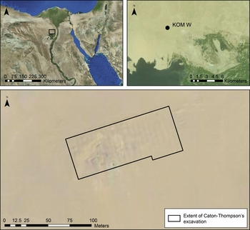
The Fayum north shore is today a hyper-arid landscape with only very occasional pockets of vegetation. In recent times, development has occurred for commercial agriculture, mining, highway construction, and housing. However, in areas where the ground surface remains undisturbed, there are extensive and rich surface archaeological deposits. North Africa in general, and the Fayum in particular, has seen considerable environmental change since the beginning of the Holocene. The African Humid period saw increased rains as the intertropical convergence zone moved northward (Kuper and Kröpelin Reference Kuper and Kröpelin2006). Periods of increased Nile flow saw Lake Qarun, presently with a surface 44 m below sea level, achieve considerably higher levels. A series of lake basins originally identified by Caton-Thompson and Gardner were intermittently flooded (Phillipps et al. Reference Phillipps, Holdaway, Emmitt and Wendrich2016a). In addition, wadis that remain today as dry channels may have flowed into the lake basins as a consequence of increased winter rainfall (Phillipps et al. Reference Phillipps, Holdaway, Wenrich and Cappers2012). Changes in the environment led to the movement of sediment as a result of both changes in local hydrology and wind erosion (Koopman et al. Reference Koopman, Kuliving, Holdaway and Wendrich2016). Contemporary development is fast destroying both the buried and surface archaeological record. However, these changes aside, cultural impacts after the mid-Holocene on the earlier archaeological record appear to have been minor (Holdaway and Wendrich Reference Holdaway and Wendrich2016). In contrast, natural processes connected with the erosion and deposition of sediments have had significant impacts on the nature and extent of the archaeological deposits. While much of the record is today formed from lagged surface deposits, stratified buried deposits exist today and may have existed more extensively in the past, and it is important to understand how these were formed and transformed through time. One of the best known of the stratified deposits is Kom W (Figure 1).
The location of Kom W in the Fayum, Egypt.

Kom W consists of a low mound (kom in Arabic) of approximately 20,000 m2 in area with pits and hearth features, faunal material, stone artifacts, and pottery among other forms of material culture. Kom W is sometimes referred to as a Neolithic village largely due to the importance Caton-Thompson and Gardner (Reference Caton-Thompson and Gardner1934) assigned to the site in their published work (e.g., Braidwood Reference Braidwood1958; Childe Reference Childe1956). Kom W represented the most extensive Neolithic deposit in the Fayum they encountered, both in the depth and extent of deposits, and in the concentration of portable material culture. Given conceptions of early agriculture at the time the site was excavated, interpretation as a village-based settlement was not surprising. However, recent reassessment of archaeological remains in Egypt calls into question evidence for villages during the Neolithic in Egypt (Holdaway et al. Reference Holdaway, Phillipps, Emmitt and Wendrich2016; Holdaway and Wendrich Reference Holdaway and Wendrich2016; Phillipps Reference Phillipps2012; Phillipps and Holdaway Reference Phillipps and Holdaway2016; Phillipps et al. Reference Phillipps, Holdaway, Emmitt and Wendrich2016b). It is important, therefore, to interpret the results from Caton-Thompson and Gardener's excavations from a modern formational perspective, particularly given the history of environmental change across the north shore. Part of this understanding involves reconstructing the topography of the site before excavation commenced.
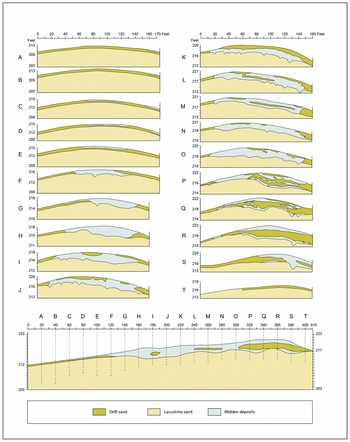
Kom W was excavated by Caton-Thompson and Gardner (Reference Caton-Thompson and Gardner1934) in their 1925–1926 season. They excavated in six trenches (A–F) measuring 20 ft (6.096 m) × 175 ft (53.34 m) and 14 trenches (G–T) measuring 20 ft (6.096 m) × 160 ft (48.768 m). Each previously excavated trench provided a recess into which the backfill of the following trench was deposited. The level of in-field recording they undertook was unparalleled in Egypt for its time. Stratigraphic sections were drawn for every one of the 20 trenches excavated (Figure 2). Pits identified at the base of the excavation cut into sterile sediments were recorded in plan, and the provenience of a number of artifacts considered typologically significant was recorded. The profile of each trench was drawn, as well as a profile along the east-west axis of the site at longitude 100 (Figure 2). In their publication, the trenches were drawn using different scales for the vertical and horizontal axes. While it cannot be determined whether the drawings were completed using these different scales in the field, the change in scale made the excavated levels more pronounced when published (Figure 2).
Twenty profile drawings of excavated strips and the east-west section at longitude 100 (digitized from Caton-Thompson and Gardner Reference Caton-Thompson and Gardner1934: Plate IV). Note that the x- and y-axis are at different scales.

Three types of deposits were identified: drift sand, midden, and lacustrine sand. The lacustrine sand deposit was considered to be a culturally sterile layer, and excavation was stopped when this layer was reached (Caton-Thompson and Gardner Reference Caton-Thompson and Gardner1934:24). It is the relationship between the two other deposits Caton-Thompson and Gardner mentioned, drift sand and midden, particularly the horizontal distribution of these deposits, that has the potential to help explain how the site accumulated and was subsequently transformed through erosion. Understanding the formation processes connected with the largest stratified deposit in the Fayum north shore is important not only in relation to the site itself but also in relation to the extensive surface deposits mentioned above.
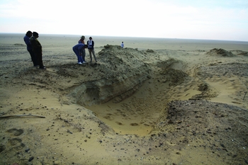
The published records in The Desert Fayum remain the only extant excavation record. While more detailed records were made at the time of excavation, these were never published, and the notes relating to the excavation were destroyed during World War II (Caton-Thompson Reference Caton-Thompson1983:211). The 1920s excavations and recent archaeological activity, in addition to large-scale destruction through looting since 2008, have changed the surface morphology of Kom W significantly, meaning that much of the detail visible when the site was first excavated is now lost (Figure 3).
A trench on Kom W dug out by looters.

DIGITIZATION OF KOM W EXCAVATION RECORDS
Here we describe how section drawings were used to create a three-dimensional representation of the site in a geographic information system (GIS) with the goal of understanding both the topography of the site before excavation and the distribution of the drift sand and midden deposits (Figure 2). Commercial software was used, including ESRI's ArcGIS and ArcScene, Adobe Illustrator, and Autodesk AutoCAD. However, the method could be implemented with other suitable software products, including a number of open-source illustrator, computer-aided design (CAD), and GIS programs.
The original drawings were turned into a digital format for manipulation using a camera, although a high-resolution scanner would also be suitable. The quality of the initial digitization depends on the size of the picture and the detail present, with smaller or coarser images needing less resolution than larger or finer images. A photograph of each of the section drawings from the published illustrations (Caton-Thompson and Gardner Reference Caton-Thompson and Gardner1934: iv) was imported into Adobe Illustrator CS5, a graphic design software package. These were digitized into hatches and coded according to the representations of deposits, features, and scales (Figure 2). Digitized scales permitted each of the drawings to be oriented relative to one another.
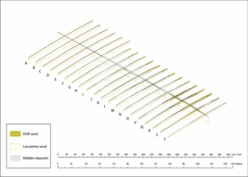
The CAD software, Autodesk AutoCAD 2015, was used for further manipulation. As noted, different scales were used in the drawings for the horizontal and vertical axes. Accordingly, in AutoCAD, the section drawings were scaled to their correct ratio in feet and rotated 90 degrees on their z-axis (Figure 4). A plan view of the Kom W excavation from Caton-Thompson and Gardner's publication (Reference Caton-Thompson and Gardner1934: iii) was added and scaled to its correct proportions in feet in order to provide a “base map” on which the section drawings could be arranged. The section drawings from the excavated trenches were lined up according to the trench they depicted, and also oriented in relation to the east-west section located at longitude 100 (Figure 2). The trench sections were adjusted on the z-axis at ground level to match the ground levels recorded along the longitude 100 east-west section. This produced a wire-mesh skeleton of the excavation of the site (Figure 4).
The 3D wire-mesh skeleton of Kom W created in AutoCAD, facing southeast.

The initial wire-mesh skeleton used a scale in feet matching the published drawings. However, this was changed to meters in AutoCAD to conform to the georeferenced coordinate system used in our current work in the Fayum (UTM 36N, datum WGS1984). The hatches that made up the skeleton were converted into polylines in AutoCAD, and additional vertices were added to these in order to give more points of reference for the shape of the deposits. The transformed wire-mesh skeleton was exported into three-dimensional GIS software, for further manipulation. As noted above, we used ESRI ArcScene 10.3. However, other open-source software could be substituted. In ArcScene 10.3, each polyline was coded according to the trench from which it was derived, its position at the top or bottom of the deposit, and the type of deposit it represented (i.e., drift sand or midden).
Our own fieldwork data collection involves recording elevation data for every point recorded. In order to relate the reconstruction of Kom W with these data, we placed the Kom W reconstruction in relation to its real world coordinates, including elevation. A copy of the surface polygon for Kom W was georectified to its real-world location using the 2D GIS software, ESRI ArcMap 10.3. A digital surface model (DSM) derived from World-View 2 satellite imagery (captured May 2012) was used to attribute an elevation to the Kom W base polygon. This DSM is accurate to 1 m, and while the topography of the site today has almost certainly been influenced by the backfill of the original excavation and subsequent modern disturbance, the ground level derived from the World-View 2 DSM incorporates data from a much larger area (Phillipps et al. Reference Phillipps, Holdaway, Emmitt and Wendrich2016a). Therefore, the DSM with its 1-m vertical accuracy provides an adequate measure for this purpose.
With the Kom W surface polygon georecitfied, the wire-mesh polyline skeleton was moved into its correct location using ESRI ArcMap 10.3. The elevations were ascribed to the polyline skeleton by altering the elevations of the entire skeleton relative to the difference between the surface level of the wire-mesh skeleton and the calculated base polygon, using the Adjust 3D Z tool in ArcMap. The result was a wire-mesh skeleton of Kom W created from the original published section drawings located in correct, real world, three-dimensional coordinates, as if these data were recorded during contemporary fieldwork.
Constructed in this way, the Kom W wire-mesh skeleton was coded by deposit and excavation trench, reflecting the way that the site was excavated rather than the form in which the deposits were encountered. To create a representation of the different deposits, each polyline code, as well as its relative position in the excavation, surface, surface of midden, or bottom of excavation, was separated into its own shapefile in ArcScene 10.3 and transformed into points. Single point files for the surface, surface of midden, and bottom of the excavation were created. Within these point files, the drift sand and midden deposits were isolated manually to create a plan view.
The points for the surface, surface of midden, and bottom of excavation were transformed into a triangulated irregular network (TIN) using ESRI ArcMap 10.3. A TIN captures the differential elevations across a surface that can be represented in two dimensions or viewed in three dimensions. This procedure introduced some interference from points generated from the polyline wire-frame, as the TIN created points in the blank spaces between the sections that Caton Thompson and Gardner left. To counter this, the TINs were converted to rasters, with elevation data stored in the matrix of cells. A low pass filter was used to reduce the impact of extreme values (by calculating average cell values based on surrounding values) and applied using ArcMap (Connolly and Lake Reference Connolly and Lake2006:198–201 provide a description of this procedure). The resulting rasters were converted back into TINs with separate coverages created for the surface, surface of midden, and base of the excavation. The new TIN displayed less variation between points than the original version.
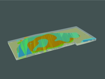
Figure 5 shows the resulting models of the surface of Kom W as it was prior to archaeological investigation, and the base of the site after the excavation was completed. In the figure, the drift sand and midden deposit polygons are overlaid on the TIN representations of the site surface and base of the excavation. The surface of the midden prior to excavation is also shown. The figure indicates that some of the midden deposit was covered by drift sand at the time of excavation, and this has implications for the formation processes that had an impact on the site prior to excavation, which we now explore.
A 3D representation of Kom W. The different midden extents are shown with the trench walls and the pit features. The midden colors correspond to those seen in plan view in Figure 6. The bottom of the trench is the lacustrine sand layer, and areas not encompassed by midden are drift sand. The midden that was visible before the excavation of the site is seen in blue, while the actual extent of the midden layer is seen in orange. Green represents the bottom of the midden as it was on the lacustrine sand and shows that some smaller pit features (in black) are located outside of the midden extent.

FORMATION PROCESSES AT KOM W
Caton-Thompson and Gardner identified 248 pit features described as holes sunk into the lacustrine sand (i.e., the basal sterile deposits). The pit features were variously described as “pot holes” (Gardner and Caton-Thompson Reference Gardner and Caton-Thompson1926) and “fire holes” (Caton-Thompson and Gardner Reference Caton-Thompson and Gardner1934:24), although the neutral term “pit feature” is used here. At least some of these pit features likely served as pot holes, since Caton-Thompson and Gardner (Reference Caton-Thompson and Gardner1934:24) record 12 examples holding complete ceramic vessels. Comparison between the diameters of different pit features and the extant bases of ceramic vessels recovered from Kom W shows a positive correlation (r² = 0.919, n = 6, p = .009), perhaps suggesting that an additional number of the pit features did indeed serve as pot holes (Emmitt Reference Emmitt2011). While pit features certainly existed in the overlying deposits, only records of those in the lacustrine sand were published.
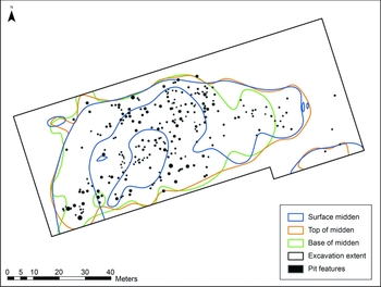
The distribution of pit features is shown in Figure 6. The diameter of each pit feature was originally recorded to the nearest foot (Caton-Thompson and Gardner Reference Caton-Thompson and Gardner1934:25), and we converted these into meters in the figure. When the distribution of the pit features is compared with the maximum extent of the midden deposit (Figure 5), there is a positive correlation between the presence of these features and the midden layer (Figure 6). Allowing for some margin of error in the identification of the midden deposits, it is likely that all but a few of the westernmost pit features were associated with this deposit type. No large pit features were present in the bottom of the drift sand layer, likely indicating that the smaller features in this deposit represent the eroded remnants of larger pits. That is, smaller pit features in the bottom of the drift sand overlap with the top of the midden, suggesting that these are the remains of truncated features dug down from the deposits above.
Distribution of pit features identified in Caton-Thompson and Gardner (Reference Caton-Thompson and Gardner1934: v) overlaid with the different extents of the midden deposits identified through the 3D reconstruction of Kom W. Areas outside of the midden deposits are drift sand. No large pit features are seen outside of the midden deposits. Note that the surface of midden and top of midden here are different as the surface of the midden represents what was visible when the site was discovered, and the top of midden is the extent of the midden without the obscuring surface drift sand.

Wendorf and Schild (Reference Wendorf and Schild1976:213–15), commenting on Kom W many years after Caton-Thompson and Gardner's work, suggested that site morphology was likely the product of post-depositional processes rather than solely the outcome of human behavior. The visualization developed here confirms their observation and indicates that, even when Caton-Thompson and Gardner encountered the site in 1925, Kom W had undergone significant wind erosion. The profile of the site suggests that the prevailing northerly wind eroded the northern end of the Kom, an area that, when excavated, lacked a large number of pits and substantial midden deposits (Figure 6). The density of material in the upper layers of the southern portion of Kom W, an area that contained a greater density of material and pits than other areas of the site, protected the buried deposits to some degree. Our work at Kom W, prior to modern looting, suggests that stone artifacts and pottery formed a protective cap across the deposit as finer sand and silt particles were winnowed away through wind action over the 90 years after the original excavation. This erosion helps to contextualize the large number of surface deposits found across the Fayum north shore. It seems likely that many stratified deposits once existed in a number of places across the area, but deflation as a result of wind erosion progressively lagged these deposits after the mid-Holocene abandonment of the region. Some stratified deposits survived at places like Kom W in the face of this erosion, but, in other areas, erosion left only surface scatters. It is possible that the drift sand helped to protect part of Kom W after the site had been partially eroded. It would be wrong, therefore, to assume that stratified and surface deposits necessarily relate to fundamentally different site types.
DISCUSSION AND CONCLUSION
Analysis of Caton-Thompson and Gardner's section drawings provides valuable insights into the formation of Kom W and indicates the context needed to help interpret the results from our recent excavation and survey work at Kom W and in the wider area (Holdaway and Wendrich Reference Holdaway and Wendrich2016; Holdaway et al. Reference Holdaway, Phillipps, Emmitt and Wendrich2016). The site was susceptible to erosion, as were many other areas on the Fayum north shore. This likely removed some of the large number of features identified at Kom W, and this may help to explain the numbers of pottery sherds that, together with flaked stone artifacts, are today visible across the surface of the Kom. It is also possible that some of the very rich surface artifact concentrations that occur within the vicinity of Kom W were formed from deposits that were originally stratified and have since lagged. This raises the possibility that concentrations of pottery at different locations came from the type of large storage jars set into depressions that Caton-Thompson recorded at Kom W. As is argued in detail elsewhere, this has important implications for understanding the nature and extent of Neolithic settlement in the Fayum region and beyond (Holdaway and Wendrich Reference Holdaway and Wendrich2016).
At a more general level, analysis of the original section drawings from Caton Thompson and Gardner's excavations shows the continued importance of legacy data in archaeology. The site descriptions, plans, and section drawings published in The Desert Fayum are the only extant records of the Kom W excavation. In the context of 1920s excavation standards, and given the global economic crisis that occurred at the time the volume was published, the amount of information Caton-Thompson and Gardner included is remarkable. The three-dimensional reconstruction of Kom W from their original excavation records provides a new understanding of the horizontal distribution of the deposits excavated. It is a testament to the recording and work of Caton-Thompson and Gardner that over 80 years after its publication, the description of Kom W in The Desert Fayum provides new and instructive information.
While the way the trenches were excavated and recorded at Kom W enabled the development and testing of the method for the three-dimensional digitization of section drawings described here, the method could be applied to other excavations, given sufficient data. In other applications, what will change will be the scale at which the reconstruction can occur. A single trench with four stratigraphic drawings (one for each section) could, for example, be reconstructed in this way. The information regarding the interior of the trench in such cases would be interpolated from the sections. Obviously, this would not provide a profile of the site before excavation in the same way as was reconstructed for Kom W, but insights might be provided, nevertheless, into the relationship between layers or elevation changes that may not be clear from the published two-dimensional section drawings. The more section drawings that are available from legacy data, the more informative the digitization will become. The example described here involves only a limited number of stratigraphic layers. In other examples where more layers are present, association and digitization will likely be a more involved process. However, the method presented here will be applicable as long as attention is paid to the relationships between layers.
As is the case with Kom W, archaeological sites worldwide are increasingly under threat. Where large-scale destruction of archaeological sites is occurring, as in Egypt (Parcak Reference Parcak2015) and Palmyra, as well as more generally across the Near East, reuse of legacy data will no doubt become increasingly important. The method presented here could be applied to many current and past archaeological excavations around the world, enabling new insights into threatened or destroyed sites and, ultimately, creating dynamic data from a static record.
Acknowledgments
Work reported here was supported by the Royal Society of New Zealand through a Marsden grant, by the National Geographic Society, and by the University of Auckland. Permission to work on the Fayum material was provided by the Egyptian Supreme Council of Antiquities and the Ministry of State for Antiquities (MSA) to the UCLA, Groningen University, University of Auckland Fayum Project (URU Fayum Project). Tim Mackrell took the photos of the original section and plan drawings. The abstract was translated into Spanish by Nicholas Keenleyside. The authors would also like to thank four anonymous reviewers for their comments on an earlier version of this article.
Data Availability Statement
The image used for the digitization of Kom W is available in Caton-Thompson and Gardner (Reference Caton-Thompson and Gardner1934).