NORFOLK
(1) Necton, Norfolk Vanguard and Norfolk Boreas Offshore Windfarms, (TG 19887 28702 to TG 16320 26590):Footnote 90 a programme of archaeological trial-trenching evaluation comprising a total of 555 trenches was excavated across 225 fields, of which 168 fields contained archaeological features.Footnote 91 The majority of features were ditches and pits, with all periods from prehistoric to post-medieval represented. The most spectacular find was the wall foundations of a previously unknown timber-built Roman villa and associated external features identified at the western extent of the scheme at Necton. A wealth of high-status finds was recovered from the building's footprint and surrounding area including a horse harness strap slide and imported pottery.
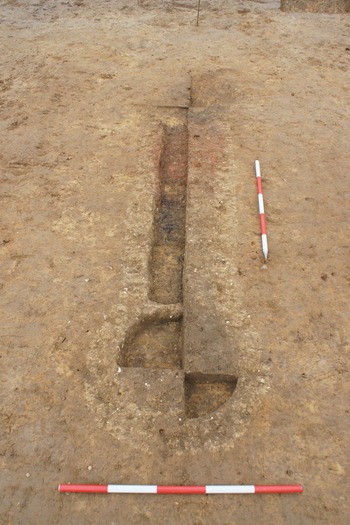
(2) Postwick, Plot 2a, Broadland Gate (TF 2897 0905):Footnote 92 a first phase of trenching (ENF148932) was followed by open-area excavation (ENF150324). The majority of the archaeology relates to land-partitioning ditches along with a possible corn-dryer (fig. 41). These remains were associated with a Roman farmstead observed on adjacent and nearby plots (to the north) which also included land-partition ditches and three possible corn-dryers as well as a post-built barn. Chronologically the earliest remains associated with the farmstead are mid-to-late first to mid-second century a.d., with activity continuing into mid-third century a.d. Cereals and flax have been cultivated, probably for export to Venta Icenorum (c. 11 km to the southwest). Roman ceramic building material including roof-tile indicates the presence of a nearby settlement which has yet to be identified. The farmstead thrived, and could afford imported fine pottery table wares, which may be due to the adoption of the crop ‘gold-of-pleasure’, evidence for which was gained from the barn structure and associated amphora.
The Broadland Gate corn-dryer, looking north. (© CB Archaeology)

SUFFOLK
(1) Multi-parish, Sunnica East sites A and B (TL 66667 73917 and TL 69045 72304):Footnote 93 large-scale evaluation was undertaken in fields across the Freckenham and Isleham parishes (Site A), also the Barton Mills and Worlington parishes (Site B).Footnote 94 While most of the site was in Suffolk, the western field (E05) was mainly in Cambridgeshire. Fields were designated separate site codes based on their parish, which corresponded to Field numbers E01–E33. Roman remains were uncovered in 11 fields, mostly as single boundary ditches or discrete areas of activity. Evaluation of the southern third of Field E03 revealed a concentration of features that produced only a few finds, which included Roman pottery and ceramic building material. Nearby, the eastern edge of Field E04 skirted an area of probable Romano-British activity (to be preserved in situ) and part of a Romano-British ring-ditch was uncovered, which continued into the area to be preserved. Finds comprised a single mid-fourth-century a.d. coin and a small assemblage of Roman pottery. Geophysical survey of Field E05 showed promising signs of enclosures along its eastern edge, with an area of Romano-British activity identified on the opposite side of Beck Road to the south. Romano-British activity was identified on the eastern field edge. Isolated pockets of Roman activity were identified in the north of Field EC01, while elsewhere, a possible Romano-British ditch was traced through Fields E17, E18, E20, E21 and E24. Within the same area, a zoomorphic La Tène brooch and three mid-fourth-century a.d. coins were recovered from the ploughsoil in Field E19, while a mid-fourth-century a.d. coin was recovered from the ploughsoil in Field E20.
SUPPLEMENTARY MATERIAL
For supplementary material for this article please visit https://doi.org/10.1017/S0068113X22000435