Introduction
The exploration and exploitation of the polar regions has left a legacy of material remains spread over the landscape. These include exploration remains such as base camps, wrecks of ships, airships, docks and mooring masts; exploitation remains including huts and depots of hunters and trappers, and ruins of structures associated with whaling, sealing, and mining; and graves, crosses and other memorials. To the casual visitor some of these sites may appear to be timeless and unchanging, a capsule of times past that has apparently been frozen in the polar environment. This perception is reflected, for instance, in narratives about huts from the early period of Antarctic exploration, or the ‘heroic era.’ ‘Visitors to the huts are fascinated by finding the legendary explorers’ belongings preserved as though they had just walked out’ (NHM undated; original emphasis). However, historical sites are subject to transformation by cultural and non-cultural (natural) processes since the abandonment by their original occupants right up to the present (Schiffer Reference Schiffer1983, Reference Schiffer1987). While the polar environment protects many sites from the type of decay encountered in temperate regions, many have experienced gradual but significant deterioration (Blanchette and others Reference Blanchette, Held and Farrell2002; Reference Blanchette, Held, Jurgens, McNew, Harrington, Duncan and Farrell2004), which has sometimes been linked to regional warming (Barr Reference Barr, Petzet and Ziesemer2008). Human presence in the polar regions has increased over the recent past, with consequential pressures not only on the wilderness and natural environment (Tin and others Reference Tin, Hemmings and Roura2008) but also on the tangible cultural heritage (for instance, Roura in press).
For historical and scientific research it is important to assess the status and change of historic sites, defined here as locations that demonstrate past human activity as evidenced by the presence of artefacts, ecofacts, features, structures, or other material remains (Kipfer Reference Kipfer2007: 50), and to unravel the different processes of site transformation. This knowledge may assist in informing decisions about site conservation and management.
This article focuses on the recent transformation of several historical sites in Antarctica and on the archipelago of Svalbard, as assessed through ground based repeat photography. Antarctica and Svalbard are inherently different but have a number of similarities that set them apart from of the rest of the polar regions. Both regions had no indigenous people and following discovery in 1596 in the case of Svalbard and no later that 1820 in the case of Antarctica they experienced successive waves of activity including exploration, natural resources exploitation, science, and tourism (Sugden Reference Sugden1982). The sequence and tempo of events were different in each case and this is reflected in the material cultural record. The earliest known historical sites in Svalbard date from the 17th century, while those in the area covered by the Antarctic Treaty and related instruments date from the early 19th century (see for instance Marstrander Reference Marstrander and Wråkberg1999; Jørgensen Reference Jørgensen2005; Harrowfield Reference Harrowfield2005; Stehberg and others Reference Stehberg, Pearson, Zarankin, Senatore, Gatica, Barr and Chaplin2008). Some historic events in Svalbard (such as mining, and active warfare during World War II) have a limited or no parallel in the Antarctic.
The territorial tensions that resulted from the terra nullius status of these regions were addressed by the 1920 Spitsbergen Treaty and the 1959 Antarctic Treaty. These treaties entered into force in 1925 and 1961, respectively. The former treaty provides for Norwegian sovereignty over the archipelago whilst maintaining equal rights for the nationals of all contracting parties, subject to some Norwegian laws (Mathisen Reference Mathisen1954; Ulfstein 1996; Pedersen Reference Pedersen2009). Article IV of the Antarctic Treaty ‘freezes’ territorial claims in Antarctica while the treaty is in force (Beck Reference Beck1986; Triggs Reference Triggs1987).
Comprehensive environmental protection regimes have been established for both regions, and in each region the same instrument that protects the natural environment also protects historical sites. These are protected as ‘cultural monuments’ in Svalbard and as ‘historic sites and monuments’ (HSMs) in Antarctica. The 2001 Svalbard Environmental Protection Act automatically protects structures, sites, and movable historical objects predating 1946, as well as cultural features such as human graves and certain animal slaughtering sites, irrespective of their age. Cultural remains postdating 1946 that are of particular historical or cultural value may also be protected by a decision of Norway's directorate of cultural heritage. Under the 1991 Protocol of Environmental Protection to the Antarctic Treaty (the protocol), Antarctic sites or monuments of recognised historical value may be designated as HSMs and also as part of protected areas (for details see Bizzarri Reference Bizzarri2006; Chile 2007a). Listed HSMs may not be damaged, removed or destroyed. In addition, remains predating 1958 whose existence or present location is not known have a degree of protection, but there is no automatic long-term protection of Antarctic cultural remains on the basis of their age alone. Past activity sites that are not protected as HSMs are subject to removal under the protocol's waste management requirements.
This article aims to answer the following questions. What are the changes experienced by historical sites in the polar regions in the contemporary past? What are the causes of these changes? And what do these changes tell us about broader contemporary developments in the polar regions? The article first discusses repeat photography as a method of monitoring the transformation of historic sites, based on Roura (Reference Roura2008a). This is followed by seven case studies documenting changes of historical features in the recent past. The article then discusses recent developments in Antarctica and Svalbard that may be linked to site specific changes. While the entire history of each site is briefly reviewed, the monitoring period focuses on the recent past (up to 20+ years). This has been a period of substantive change in Antarctica and Svalbard including the establishment of environmental protection regimes, the expansion of polar tourism, advances in heritage conservation, and emerging evidence of climatic changes. These and other contemporary processes may directly or indirectly contribute to the transformation of historical sites in the sense of greater protection or ultimate destruction. Knowledge about recent changes is particularly relevant to the contemporary management of historic sites, even though the interest in historic site transformation transcends management applications.
Methodology
Repeat photography as a research method
Historical sites in Antarctica and Svalbard may range from large, complex sites comprising many buildings, structures, and ruins, to sites with virtually no traces of past human activity. Change at a site can be rapid and obvious. A wood frame building may be destroyed in a storm, for instance, or the remains of an expedition camp may be salvaged or reused in another context. Change can also be gradual and subtle, as reflected in the ‘frozen in time’ narratives about huts from the ‘heroic era’ of Antarctic exploration, which suggest virtually untouched remains. Over time, however, cumulative changes may well result in significant site transformation. The opportunistic use of ground based repeat photography provides a relatively simple way of monitoring the transformation of these sites.
Repeat photography, or photo monitoring, means using photographs taken at a specific site to monitor conditions or change over time (Hall Reference Hall2001). This technique is often used to assess changes to natural and cultural landscapes (for instance, Rogers and others Reference Rogers, Malde and Turner1984; Ahlstrom Reference Ahlstrom1992; Nyssen and others Reference Nyssen, Haile, Naudts, Munro, Poesen, Moeyersons, Frankl, Deckers and Pankhurst2009). The method may use photographs specifically collected for monitoring purposes, or the replication of historical collections. In addition to scientific assessments repeat photography has been used to highlight and publicise decadal or rapid environmental changes (Greenpeace 2002; ICIMOD 2008; EIS 2009). In the polar environment repeat photography, whether aerial or ground based, has been used for a broad range of purposes including assessing the effects of regional warming on glaciers (Fox and Cziferszky Reference Fox and Cziferszky2008), lichen growth (Smith Reference Smith1995), the environmental footprint of contemporary activities (New Zealand 2006), and the status and change of historical sites (Governor of Svalbard 1999a). Analysis methods for ground based repeat photography include using grids or spatial analysis software to measure surface changes of the features of interest (Hall Reference Hall2001, Reference Hall2002; Tape and others Reference Tape, Sturm and Racine2006; Roush and others Reference Roush, Munroe and Fagre2007), expert rating of key indicators (Nyssen and others Reference Nyssen, Haile, Naudts, Munro, Poesen, Moeyersons, Frankl, Deckers and Pankhurst2009), and broad whole photo comparisons (Tape and others Reference Tape, Sturm and Racine2006; Masiokas and others Reference Masiokas, Villalba, Luckman, Lascano, Delgado and Stepanek2008). Overall, while the basic technique is the same, data collection and analysis methods may differ significantly depending on the purpose of monitoring and the quality of the photo couples.
Obviously repeatability is a key element in repeat photography. This requires a monitoring protocol and support documentation that enables locating historic vantage points and replicating earlier photographs (Hall Reference Hall2001, Reference Hall2002). Precise replication, that is, when photographs of a certain feature are taken from exactly the same camera position and direction using identical camera formats, may be achieved through putting in place two permanent markers, one indicating the camera position and the other the direction of the photograph from that position (see Hall Reference Hall2001 for details; see also Smith Reference Smith2007 for an alternative method). In contrast, ‘casual repeat photography’ refers to the matching of photographs not specifically collected according to a monitoring protocol, but that nevertheless overlap sufficiently so that comparisons are possible (Ahlstrom Reference Ahlstrom1992; Cameron Reference Cameron1999). In the polar regions photographs of important sites may not have been collected with monitoring in mind so that there is no record of vantage points or other technical information; site visits may be infrequent, opportunistic, and brief; and environmental regulations may discourage the establishment of permanent markers. Under those circumstances casual repeat photography may be a practical alternative. Photo couples alone, however, are insufficient to assess the transformation of sites; a conceptual framework for analysis is also required.
Data collection
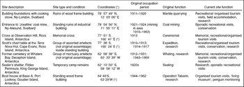
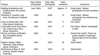
Data collection for this research was based on the reproduction of existing photographs not specifically collected for repeat photography. Research focused on specific features representing a fraction of larger sites. Seven historic features were selected representing a selection of site types, conditions, and past and present site functions for which a set of comparable photo couples had been assembled (Table 1). Matching photographs were taken either in the context of dedicated fieldwork or during opportunistic visits to the sites. Additional matching photographs were found in personal collections, publications, and on the World Wide Web. The earlier or ‘before’ photographs, dating back to up to 20+ years, were reproduced in order to obtain recent or ‘after’ photographs (Table 2). The outcome was several sets of paired photographs or photo-couples, which were broadly comparable but not identical. The relatively short time period covered by repeat photography was meant to illustrate recent changes; indeed, some historic features had long been abandoned and were already ruins when monitoring began. The information contained in the photographs was complemented with on site observation of contemporary human behaviour and activities, site surveys of different kinds, interviews, and information from secondary sources. These methods are discussed elsewhere (Roura Reference Roura2008a, Reference Roura2009, in press). Site visitation data were obtained from IAATO (undated), New Zealand and others (2006), and Governor of Svalbard (2006).
Case study sites

(*) Coordinates are from legal instruments designating site as Historic Sites and Monuments and give an approximate position.
Repeat photography characteristics

Data analysis
The interpretation of changes was made using the concepts developed by Schiffer (Reference Schiffer1983, Reference Schiffer1987) to identify the factors that create the historic and archaeological record, or site formation processes. In cultural formation processes the agency of transformation is human behaviour. In non-cultural, or natural, formation processes the agency of transformation is provided by the processes of the natural environment (Schiffer Reference Schiffer1987: 7). Thus, any cultural or natural process acting on a historical site contributes to the transformation of that site and adds its own patterns over previously existing patterns. The effect of these processes would be to add to, remove from, or change the condition/integrity, location or orientation of artefacts within a historic site, and to introduce changes to the way individual artefacts relate to each other in space.
Data analysis evaluated noticeable macroscopic changes to individual components of historical features. An inventory was made of the separate objects that could be identified with certainty in both the ‘before’ and ‘after’ photographs. For this, 20×30 cm print outs of the photographs were used. This step identified a sub sample of the total population of cultural objects in the photographs. The contour of each of the objects included in the inventory was drawn in a sheet of acetate using a permanent marker. The lowest definition photograph of the set was used as a base for the drawing. Each of these objects was individually numbered. Buildings and other large features were counted as a single object.
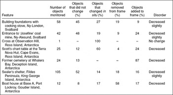
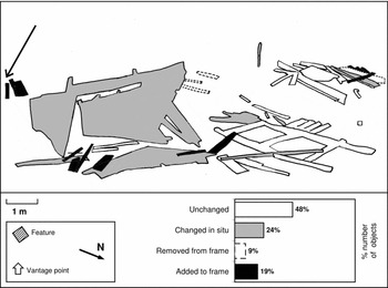
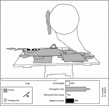
Individual objects were classified on the basis of their observable attributes: material (and hence density), size, and shape. Each individual object was compared in the ‘before’ and ‘after’ photograph to assess whether or not it had changed over time. Changes were classified as additive, reductive or in situ. By this it is meant that objects had been added or removed to the photograph's frame, or that had remained within the photograph's frame but had changed in size, shape, form, position, or spatial location (Tables 3 and 4). In case of uncertainty (due to parallax or definition differences in the photo couple) the object was dropped from the analysis. The changes were drawn in the acetate sheet outline using a three-tone pattern, which eliminated unnecessary detail.
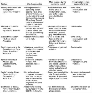
Site characteristics, main changes, and interpretation

Summary of changes

A judgement was made of the degree of disorder introduced by the changes through a whole photograph assessment (Table 4). Disorder, in this context, concerns the formal, spatial and relational arrangement of material cultural elements (as defined by Schiffer Reference Schiffer1983, Reference Schiffer1987). For instance, greater disorder results from the breakage of individual objects (formal), or from disaggregating groups of objects that were previously together (spatial and relational). Greater order results from repairs or maintenance (formal), or the aggregation, alignment or stacking of objects (spatial and relational).
Case studies
The discussion now turns to actual examples of recent changes to historical features in Antarctica and Svalbard. The features covered approximately 1–100m2 in surface area and were in most cases part of larger, complex sites up to about 1 km2 in surface area that were active at various times during 1820s–1950s. All but one of the sites discussed here were legally protected under applicable legislation at the time of writing.
Building foundations with cooking stove, Ny-London, Svalbard
Ny-London on Kings Bay, Svalbard (78° 57′49″ N, 12° 02′56″ E), is the site of an abandoned marble quarry of the Northern Exploration Company Ltd. of England. The quarry operated intermittently between 1911 and 1920. The venture was unsuccessful as the quarried marble blocks crumbled during storage due to the effect of frost. Following a 1933 visit Ny-London was described as ‘. . .a few tumble-down. . .huts and machine houses, the relics of yet another unsuccessful mining venture’ (Polunin Reference Polunin1945: 90). The settlement's materials and equipment were scavenged for reuse elsewhere, and in the 1950s most buildings were taken to Ny-Ålesund where some of them are still in use. Currently most structures at Ny-London, except two wood frame buildings, are standing ruins or ruins. There are also two quarries, a gravel rail bed, refuse dumps, and artefact scatters. The two standing buildings are maintained and still used periodically for shelter and recreation by government field officers and residents of nearby Ny-Ålesund. Organised tourist landings also take place regularly through the summer. Visitor numbers have increased from less than 100 visitors in 1996 to more than 1500 in 2006. The site is automatically protected under the 2001 Svalbard legislation (Governor of Svalbard undated; Roura Reference Roura2008a).
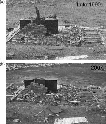
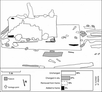
A brochure produced in the late 1990s (Governor of Svalbard undated) contained nine photographs illustrating eight different cultural features of Ny-London. These photographs were reproduced opportunistically during fieldwork in July 2007 (Roura Reference Roura2008a). For the purposes of this article the analysis will focus on a single feature, a house foundation in which a cooking stove remains standing (78° 57′ 49″ N, 12° 03′ 06″ E) (Fig. 1). This feature stands out in the landscape and is close to the beach at which most visitors land and to the buildings used as field accommodation. It is therefore one of several cultural features of Ny-London where visitors tend to congregate. The definition of the ‘before’ photograph was poor; consequently, the analysis focused only on the most obvious changes (Fig. 2). Among some minor changes to small objects, some objects placed on top of the stove visible in the late 1990s, which at some point had been used for shooting practice, had been removed from that position some ten years later. However, an on-site examination of the stove showed that in 2007 these objects were still on the site albeit not visible from where the photo-couple had been taken. Some objects were lying on the building floor and others had been stored inside the cooking stove. This suggested that the rearrangement of objects had resulted from a combination of wind action and human agency.
House foundations with a cooking stove, Ny-London, Svalbard, in the late 1990s and in 2007. 1990s photograph by Governor of Svalbard. 2007 photograph by author.

Overview of changes to house foundations with a cooking stove, Ny-London, Svalbard, between the late 1990s and 2007. Sketch based on photograph from the late 1990s. Key: white = no changes; grey = changes within the frame; dashed line = removed from frame; black = added to frame. Sketch by author.

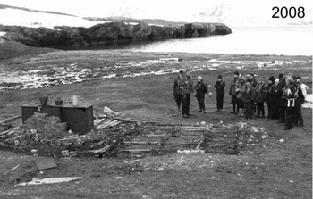
A photograph of the same site taken in 2008, that is, a year after the ‘after’ photograph described above showed further changes to the site (Fig. 3). Some objects had been replaced on top of the stove, and other objects had been removed from sight or had changed position within the frame. Overall, the condition and integrity of the site did not change significantly between 1997 and 2007, or between 2007 and 2008. However, it is apparent that the site is not static; that it is regularly visited; and that cultural remains that had once been used as shooting targets are now put on display for visitors.
Tourists visit Ny-London, July 2008. Note items on the top of the stove that were absent in 2007. Photograph by M. Loonen.

Entrance to ‘Josefine’ coal mine, Ny-Ålesund, Svalbard
Ny-Ålesund (78° 55′ 38″N, 11° 56′ 00′E) is a former Norwegian mining settlement established in 1916. Between 1926 and 1928 it was the base for several attempts to reach the North Pole by air. Since 1964 Ny-Ålesund has operated primarily to support science, and it has now become an international research centre. Ny-Ålesund is run by Kings Bay AS, a Norwegian crown company. The former mining area is located approximately one kilometre south of Ny-Ålesund between the lower slopes of Mount Zeppelin and the sea. The area covers approximately 1.1 km2 at the surface level and contains the remains of nine mines. The older mines, which are located uphill some 50–100 meters above the sea level, were developed between 1916–1923, while lower altitude mines were developed between 1941–1946. A mining disaster on 5 November 1962 resulted in the death of 21 people, and caused the end of coal mining at Ny-Ålesund (Hanoa Reference Hanoa1993; Arlov Reference Arlov1996; Governor of Svalbard 1999b).
Surface features in the mining area include some surviving structures of the mines, such as entrance points and ventilation shafts; transport infrastructure such as train tracks, skips and bridges; waste materials such as wood piles, and 200 litre fuel drums; artefacts such as shovels, borers and coal cars; landscape modifications such as gravel roads and rock dumps; and memorials to the dead. The mining area is also a gravesite for those miners who died there and whose bodies were not recovered. The area is protected under the provisions of the 2001 Svalbard legislation and by Kings Bay AS local land planning regulations. Nothing can be removed from the area and nothing can be built within its limits (B. Paulsen, personal communication, 9 July 2007). There is limited contemporary activity at the mining area itself, which is currently off limits for organised tourism. Recent management of the mining area has been based on the main principle of leaving things as they are. Between 1997 and 2004 the historic significance of cultural remains was assessed, some old dumpsites and contaminated sites that posed a hazard to the environment or to wildlife were cleaned up, and some historic features were restored (Sander and others Reference Sander, Holst and Shears2006: 15–17).
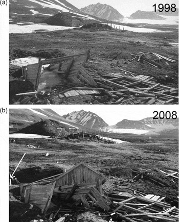
In June–July 2007 the author carried out a pedestrian survey of the mining area, documenting the various surface features of the area, and interviewed mining veterans. In 2008 a colleague, M. Loonen, replicated nearly thirty photographs dating from 1998 (reproduced in Governor of Svalbard 1999b). This case study concerns the entrance of Josefine (78° 54′ 56″ N, 11° 55′ 11″ E), a coalmine established in 1921 and abandoned in 1924 (Fig. 4). The mine entrance itself is filled up with ice, but the wooden structure above is still standing. It is one of the best preserved mining structures in the area. In the ‘after’ photograph it is apparent that, among other minor changes to surface remains, part of the entrance roof has been restored (Fig. 5). This is counterintuitive in the context of the old mining area, which is a complex, seemingly chaotic site that suggests ongoing degradation rather than renewal.
Entrance to ‘Josefine’ coal mine near Ny-Ålesund, in 1998 and 2008. The arrow in the right photograph shows a wooden peg planted by mining veterans in 2006 to identify the site. 1998 photograph by Governor of Svalbard. 2008 photograph by M. Loonen.

Overview of changes to the entrance to the ‘Josefine’ coalmine near Ny-Ålesund between 1998 and 2008. The arrow in the 2008 photograph shows a wooden peg planted by mining veterans in 2006 to identify the site. Sketch based on 1998 photograph. Key: white = no changes; grey = changes within the frame; dashed line = removed from frame; black = added to frame.

To the casual visitor the chaotic appearance of the mining area raises questions as to why such place on the edge of the Arctic wilderness is protected at all. Pearson and McGowan (Reference Pearson and McGowan2000) discuss criteria for the protection of historic coalmines and while they focus on Australian mines the basic concepts are broadly applicable elsewhere. Historical coal mines may be significant because of the attributes or combination of attributes of the coalmine above ground features that make it a good example of a mine of a certain location or period. Coalmine features that are rare, uncommon or of particular interest because of their good condition, age, or combination of features demonstrating the mining operations may also be factors for conservation (Pearson and McGowan Reference Pearson and McGowan2000). However, given the overall poor condition of the mining remains in Ny-Ålesund the conservation criteria does not seem to apply to the more recent mines in the area (dating from 1946), although they may apply to the older mines (dating 1916–1923), whose surface features are somewhat better preserved and automatically protected under Svalbard's 2001 legislation.
Pearson and McGowan (2000: 156–157) further note that ‘[t]he significance of mining features which satisfy or do not satisfy the above attributes might be enhanced by association with specific historical events (such as major mine disasters), technological innovations developed at the site, or strong or special meaning for a particular community or group.’ In this regard, the significance of the old mining area at Ny-Ålesund is manifold. First, 82 people died in mining accidents at Ny-Ålesund over the years, and as noted above the mining area still contains human remains. Secondly, the mining area itself is a reminder of significant events in the political history of Norway since the 1962 disaster resulted in the fall of the government. Finally, mining veterans (some of whom are survivors of the 1962 accident) constitute an active interest group that is concerned about the disappearance of both the physical remains of mining and the memory of the mining times. According to a mining veteran, nowadays residents and tourists alike know little about Ny-Ålesund's mining past. For them, Ny-Ålesund is primarily associated with exploration and science (L. Kristiansen, personal communication, 29 June 2007). Yet, for the miners the mining times were significant and represent a key part of their identity, even though some workers spent a relatively short part of their working lives in the coalmines at Ny-Ålesund (O. Bye, personal communication, 29 June 2007). As part of several initiatives to maintain the memory of mining times, in 2006 a group of veterans and their supporters marked with pegs and documented several sites of interest around the mining area so that their location would not be lost (Paulsen Reference Paulsen2006). One of those pegs, marking the entrance to ‘Josefine’, is visible in Fig. 4b.
Cross at Observation Hill, Ross Island, Antarctica
The cross at Observation Hill (77° 51′S, 166° 41′E) was erected by members of the British Antarctic Expedition of 1910–1913, in memory of Captain Robert Falcon Scott's party, which perished on the return journey from the South Pole in March 1912. The cross is composed of two layers of jarrah (Erythrophleum chlorostachis), an Australian native wood, which are bolted together to double the thickness. Carved in the cross are the inscription ‘In Memoriam’, the names and titles of the five members of the South Pole party, and the closing lines of Alfred, Lord Tennyson's Ulysses: ‘To strive, to seek, to find, and not to yield’. The cross faces south onto the Ross Ice Shelf, the direction in which Scott's party left, never to return, and the original position in which the cross was placed on 1913:
Tuesday, January 22. Rousing out at 6 A.M. we got the large piece of the cross up Observation Hill by 11 A.M. It was a heavy job, and the ice was looking very bad all round, and I for one was glad when we had got it up by 5 o'clock or so. It is really magnificent, and will be a permanent memorial which would be seen from the ship nine miles off with a naked eye. It stands nine feet out of the rocks, and many feet into the ground, and I do not believe it will ever move. When it was up, facing out over the Barrier, we gave three cheers and one more. (Cherry-Garrard Reference Cherry-Garrard1937: 567).
The cross has been protected as HSM 20 since 1972. The cross is adjacent to McMurdo station, the largest station in Antarctica, with some 250 winter residents and 1000 summer residents. Observation Hill, as its name suggests, overlooks the surrounding area, and therefore is frequently visited by local residents. It is one of the few places in the area that residents are allowed to visit on their own. A few hundred tourists visit McMurdo every year, and presumably some of them are able to visit Observation Hill. In the 2007–2008 summer the author examined the cross and broadly replicated photographs taken in the course of several visits to the area through the 1990s. A visual examination suggested that the cross was in good condition, and it was apparent that it had been recently restored. The inscriptions are fading as a result of abrasion by wind transported ice particles and sediments. Some of the letters, which had originally been engraved in the wood and at some point painted white, are now protruding from the surrounding surface.
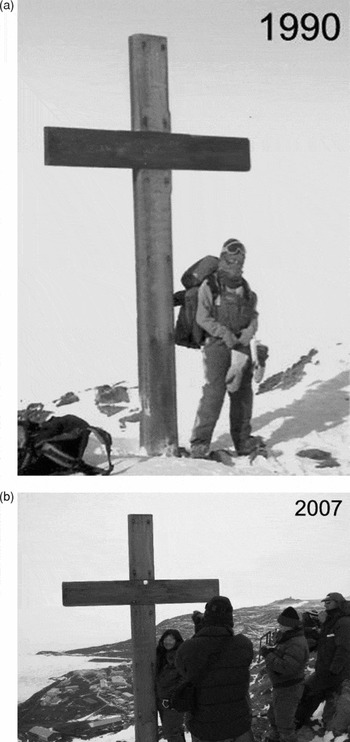
At some point in time the orientation of the cross was changed 180° from its 1913 position facing south, as described by Cherry-Garrard, to a north-facing position. The circumstances of this change are unknown to the author. The photo couple (Fig. 6) shows that in 1990 the cross still faced to the north, while it now faces to the south, that is, it is back in its 1913 original position. In addition, the cross is now shorter than in 1990: the person standing under the cross in 1990 (Lillian Hansen) is approximately 1.7 meters tall, while the person standing in a similar position in 2007 (Chiu-Pih Tan) is some ten centimetres shorter. Estimating the distances between the highest point of the cross, and the top of the heads of the people below suggests that the cross was some 40cm longer in 1990 than in 2007.
Cross at Observation Hill, Ross Island, Antarctica, in 1990 and late 2007. The cross is facing in opposite directions in each of the photographs, and it is shorter in 1990 than in 2007. Photographs by author.

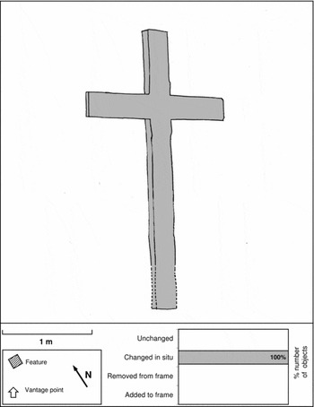
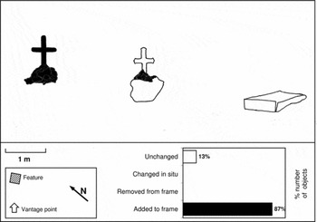
The changes to the cross’ orientation and integrity since 1990 (Fig. 7) may be explained by the fact that it was downed by hurricane force winds in June 1993. The cross was restored by members of the New Zealand Antarctic programme and transported back by foot to the top of the 230 m hill by a team from the nearby stations from the United States and New Zealand (NZAHT 2008). There are some minor dents and scratches on the cross, some of which may be related to its downhill fall (or falls). At the back of the cross there are some faint traces of engraved graffiti. The cross stands on a concrete base, upon which some people have written down their names. These inscriptions are recent and presumably made by some of those who transported the cross back to the top of Observation Hill since they were made before the cement set. The fact that the cross is shorter now than in 1990 suggest that was broken off at the ground level when it fell.
Overview of changes to the cross at Observation Hill, Ross Island, Antarctica, between 1990 and 2007. Sketch based on 1990 photograph. Key: white = no changes; grey = changes within the frame; dashed line = removed from frame; black = added to frame. Sketch by author.

Other traces suggested recent contemporary activity. The 2007 photograph shows a stain at the base of the cross, and in the field it was quite apparent that somebody had recently urinated there. This act could be an intentional desecration or just thoughtlessness. A few meters to the south of the cross there are two strings of Tibetan flags, which were not there in the 1990s, and which seem to reflect the travels, beliefs or fashions of McMurdo's inhabitants. The restoration and relocation of the cross suggest that its historical values are maintained and reinforced. However, the top of Observation Hill, because of its location and characteristics, seems to have acquired multiple functions that transcend the events of the ‘heroic era’. These include being a place of recreation and refuge for McMurdo's residents; a place where contrasting religious symbols are placed; and even a suitable place for the exercise of bodily functions.
Scott's chart table at the Terra Nova Hut, Cape Evans, Ross Island, Antarctica
The Terra Nova Hut at Cape Evans (77° 38′S, 166° 24′E) was built in January 1911 by the British Antarctic Expedition in Terra Nova, of 1910–1913, led by Captain Robert Falcon Scott, RN. The Ross Sea party of Sir Ernest Shackleton's Imperial Trans-Antarctic Expedition of 1914–1917 subsequently used it as a base. Afterwards the hut was abandoned and, according to Harrowfield (Reference Harrowfield2005), not revisited until 1947 (see also Roura Reference Roura, de Poorter and Dalziell1996). For the following decades the activities at the hut interspersed visitation by United States and New Zealand expedition members and sporadic attempts to clean up and restore the site (Harrowfield Reference Harrowfield2005).
The hut is weathered but still structurally sound. However, over the years it has deteriorated markedly due to snow accumulation, modern interventions, and the decay or disappearance of artefacts, sometimes through souvenir collection (NZAHT 2004). The hut and surrounding area contains approximately 8,000 artefacts, some of which have been described as ‘iconic’, that is, ‘. . .those elements of the building fabric or artefacts that are of such extremely high cultural heritage value that their loss would result in a serious diminution of the heritage value of the site’ (NZAHT 2004: 87). The hut has been protected as HSM 16 since 1972. Additional protection to the hut and surrounding area is provided by designation of the site as Antarctic Specially Protected Area (ASPA) 155 since 1997. Visitors require a permit issued by competent authorities to enter the ASPA. Visitor numbers are capped at 2,000 annually.
Conservation, research and visitation are the main contemporary activities at the hut. The hut is subject to a conservation project conceived and carried out by the New Zealand Antarctic Heritage Trust, a charity formed in 1987. Conservation work, which is its current phase began in 1999, is planned to last until 2014 (NZAHT 2004; NZAHT undated). Approximately 1200 people visited the Terra Nova Hut every year through the early 2000s, two thirds of whom are residents from McMurdo Station and Scott Base, located some 30 kilometres away. The number of tourists in organised cruises, however, is relatively low at about 400–500 per annum.
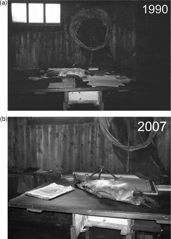
During a brief visit in December 2007 photographs taken in the course of several visits to the hut through the 1990s were broadly replicated (Fig. 8). One of those sets of photographs is that of Scott's chart table. Entering the private space of RF Scott, the inner sanctum of the Terra Nova hut, is arguably the climactic moment of a visit to the hut. The cubicle contains Scott's bed, bookshelf, his Mackintosh raincoat, and other personal objects. The chart table with the stuffed Emperor penguin lying on it and a collection of documents and other objects, under the faint light of a small double glazed window, occupies a dominating place in the cubicle. A well-known 1911 photograph by Herbert Ponting shows Scott writing his journal at the chart table while smoking a pipe. In that picture the table is clear of objects, barring Scott's journal and a tin of tobacco. The table Scott used in 1911 does not appear to be the same as the one occupying the same place decades later.
The chart table of R.F. Scott in the Terra Nova hut at Cape Evans, Ross Island, in 1990 and late 2007. Photographs by author.

Comparing the 1990 and 2007 photographs it is apparent that the somewhat disorderly arrangement of objects on the chart table has been replaced by a tidy ‘tablescape’ (Fig. 9). Cultural processes are clearly the main processes of change in this case, although they may have in turn been triggered by the effect of the environmental conditions within the hut on the objects lying on the table (soft rot, fungi, corrosion and other problems affect the objects inside the hut, see for instance Blanchette and others Reference Blanchette, Held and Farrell2002, Reference Blanchette, Held, Jurgens, McNew, Harrington, Duncan and Farrell2004). Currently the hut is subject to an ambitious conservation programme that aims to stabilise, maintain and repair the hut and its artefacts. This may involve ‘. . .to undo inappropriate interventions during the modern era and reflect more authentically the heroic era use of the hut’ (NZAHT 2004: 101). Other features of the hut and many of its artefacts are now being restored and rearranged in comparable ways.
Overview of changes at the chart table of R.F. Scott in the Terra Nova hut at Cape Evans, Ross Island, Antarctica, between 1990 and late 2007. Sketch based on 1990 photograph. Sketch by author. Key: white = no changes; grey = changes within the frame; dashed line = removed from frame; black = added to frame.

The changes illustrated in this set of photographs reflect carefully planned conservation actions that contrast with some of the ad hoc measures taken in the past (see for instance Harrowfield Reference Harrowfield2005). However, the ongoing conservation interventions have been criticised as too intrusive (Save the Huts undated). From this critical perspective the Terra Nova hut and other huts from the ‘heroic era’ are now mediated environments rather than the time capsules they once were and still purport to be. The disassembling and reordering of objects may give the impression that the hut is now in the same state that it has been since the ‘heroic era’, when this is no longer the case: ‘[t]he hut will be changed to the [New Zealand Antarctic Heritage] Trust's version of its history – not to any ‘authentic’ 1909 state.’ (Save the Huts undated). A further concern is the loss of value and information, in a scientific sense, which results from changes such as removing the patina of time from historic objects during the conservation process, the rearrangement of objects, and the disposal of objects in poor condition.
Regardless of the position adopted with regards to the conservation of the hut, what is perhaps most remarkable is that the measure of disorder in the arrangement of objects in a remote hut in the Antarctic, last inhabited in 1917, is not increasing but decreasing. This challenges the notion of what constitutes a ‘time capsule’. Rather, the hut as it is now reveals much about contemporary notions of what the heroic past ‘should’ look like and not solely about the actual ‘heroic era’ of Antarctic exploration.
Former cemetery at Whalers Bay, Deception Island, Antarctica
Deception Island in the South Shetland Islands is a ring shaped island about 12km in diameter, with a narrow entrance into Port Foster, a central landlocked harbour (a flooded volcanic caldera). Activities in the island have included sealing (1820s), industrial whale processing (1912–1931), scientific base operations (from 1944), and organised tourism (from 1958). A 1969 volcanic eruption forced the evacuation of the island and caused a significant destruction of some active and abandoned buildings and other features.
Whalers Bay (62° 59′S, 60° 34′W) on the eastern part of Port Foster, contains the remains of a whaling factory, which was abandoned in 1931, as well as the remains of the British Base B, which was abandoned following the 1969 eruption. One of the whaling factory's features was a cemetery (approximately 62° 58′ 38″S, 60° 33′ 39″W) established in 1908. The cemetery contained the graves of 34 Norwegian, Swedish, Chilean, and Russian whalers buried there in the first part of the 20th century, and a British burial from the 1950s (Headland Reference Headland, Valencia and Downie2002: 93) although some believe that the correct number of burials is 36 rather than 35 (J. Berguño, personal communication, 7 July 2009). A memorial was erected for ten men lost at sea, nine of which bodies were not recovered (Headland Reference Headland, Valencia and Downie2002: 93). The cemetery was described thus following a visit in 1947:
A metal fence, with its door open for the rare visitors, surrounds the grounds. . .in the centre [of the cemetery] a crumbling stele commands over five wavy rows of wind-weathered graves. There are humble graves with a coarse wooden cross, some with faint names and dates that nobody could read any longer. . .A mound keeps the ashes [sic] of the victims of the Graham, sunk in 1924. . .The most moving grave among all is that of. . .a [16 years old], just a child, who lies [there] in his earthy nest. (Orrego Vicuña Reference Orrego Vicuña1948: 117–118; author's translation)
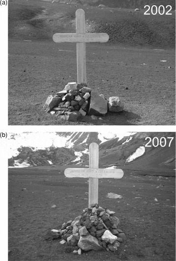
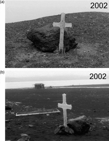
During the 1969 eruption the cemetery was partly buried and partly removed by a lahar (a mud and ash flow caused by a volcanic eruption). Headland (Reference Headland, Valencia and Downie2002) speculates that some memorial objects fell down and that some low lying grave markers may still be in their place beneath the surface of the volcanic deposits. The remains of a coffin resurfaced from the ground years after the eruption, possibly not in its original location but where the lahar took it. A cross remembering Hans Gulliksen, a Norwegian carpenter, was sent by his relatives around 1972 to replace the original cross, which had disappeared during the eruption (Fig. 10a) (Barr and Downie Reference Barr and Downie2002). In February 2002 a wooden cross situated on a hillside next to Argentina's Base Decepción in Fumarole Bay, about ten kilometres northwest from Whalers Bay, was identified to be that of the Norwegian whaler Peder Knapstad (Fig. 11a). The cross was relocated to Whalers Bay and placed close to the coffin (Fig. 11b) (Barr and others Reference Barr, Downie and Sánchez2004).
Gulliksen's cross at its original location in Whalers Bay, Deception Island, Antarctica in 2002 and after relocation within Whalers Bay in 2007. Photographs by A. Bendala.

Knapstad's cross at its hillside location at Fumarole Bay, Deception Island, Antarctica, in February 2002, and just after being re-erected at Whalers Bay on 18 February 2002. Photographs by author.

The site of the cemetery was designated as HSM 31 in 1972. All historic sites at Whalers Bay were subsumed into HSM 71 in 2005. Following its designation as an Antarctic Specially Managed Area (ASMA) in 2005 under the provisions of Annex V of the protocol, Deception Island is managed internationally. Organised tourism landings frequently take place at Whalers Bay, with over ten thousand visitors landing there every summer. Other visitors to Whalers Bay include national programme personnel conducting scientific research or on recreational visits, and yacht crews. The island's management plan contains provisions for the conducting of tourism landings, complemented with non binding site specific guidelines.
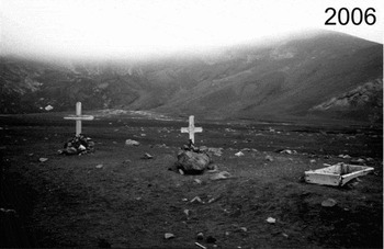
Several comparable sets of photographs taken by the author and other visitors between 2002 and 2006 were collected for this case study (Figs. 10, 11). Since 2001–2002 Gulliksen's cross has been removed from its original location some 400m away and placed next to Knapstad's cross and the coffin remains (Fig. 12). Small rock cairns have been built under each cross in the past few years, adding to the rocks initially put in place to support them.
The complex of mortuary features at Whalers Bay, Deception Island, Antarctica, early in 2006. Visitor footprints are apparent on the ground around the features. Photograph by L. Hacquebord.

The changes observed between 2001–2002 and 2004–2005 (Fig. 13) result from active management and tourism. Barr and Downie (Reference Barr and Downie2002) recommended that all mortuary elements should be placed together and apparently this has been acted upon (Figs. 10b, 12). The original cemetery has not been reconstructed but has been somehow recreated approximately where it used to be. The cairns most likely developed as a cumulative feature built by accretion. Visitors at polar historical sites follow a basic behavioural repertoire that includes making a record of the visit either by taking something from the site (for instance, photographs) or by leaving something on the site (for instance, a signature in a visitors book) (Roura in press). It is interpreted that many of the rocks in these cairns would have been placed spontaneously by successive visitors to Whalers Bay as a record of their visit and as a mark of respect and permanence (what Schiffer (Reference Schiffer1987: 80) calls ‘offertory shrine’).
Overview of changes to the complex of mortuary features at Whalers Bay, Deception Island, Antarctica, between 2002 and 2006. Sketch based on 2006 photograph. Assumes that the rocks in the cairns were added to the frame. Sketch by author. Key: white = no changes; grey = changes within the frame; dashed line = removed from frame; black = added to frame.

Sealer's shelter, Fildes Peninsula, King George Island, Antarctica
The remains of early 19th century sealing shelters in the South Shetland Islands are the oldest known sites in Antarctica (Stehberg and others Reference Stehberg, Pearson, Zarankin, Senatore, Gatica, Barr and Chaplin2008; see also Lewis Smith and Simpson Reference Lewis Smith and Simpson1987). The South Shetland Islands were discovered in 1819. Almost immediately the populations of fur seals Arctocephalus gazella were intensively exploited. The first sealing period lasted only from 1819 to 1827, peaking in the 1820–1821 season, and ended with the commercial extinction of the fur seals, although later in the century the exploitation was restarted on several occasions (Pearson and Stehberg Reference Pearson and Stehberg2006). The sealers’ modus operandi has been described as follows:
Gangs of sealers were put ashore from a ship or sent off in smaller boats to seek beaches where seals congregated or to scrape and dry skins, while the ship went off to safer anchorage or to deploy more sealing gangs. The sealers had to improvise their own shelters while ashore, and it is the stone bases and timber roof beams of these shelters that are now found around the beaches (Pearson and Stehberg Reference Pearson and Stehberg2006: 338).
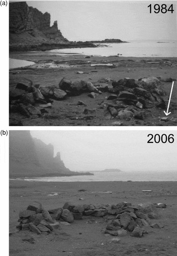
Many of the sealing sites at Fildes Peninsula in King George Island have been described by Stehberg (Reference Stehberg, Barr and Chaplin2004), Pearson and Stehberg (Reference Pearson and Stehberg2006), and Stehberg and others (Reference Stehberg, Pearson, Zarankin, Senatore, Gatica, Barr and Chaplin2008) (see also Chile 2007b). One of the best preserved sites in the area is known as Cuatro Pircas (62° 10′ 00″S, 58° 58′12″W). This is a complex of four drywall stone enclosures and associated artefacts located in one of beaches of Fildes Peninsula facing north to the Drake Passage. A photograph of the largest and best preserved structure taken in 1984 by R. Stehberg (reproduced in Stehberg Reference Stehberg, Barr and Chaplin2004: 69) was repeated by the author in 2006 (Fig. 14). Unlike the other sites discussed in this article, to date the sealing sites are not protected by legally binding regulations.
a-b. Sealer's shelter at Cuatro Pircas, Fildes Peninsula, King George Island, Antarctica in 1984 and 2006. The arrow on the earlier photograph shows fragments of pottery. 1984 photograph by R. Stehberg. 2006 photograph by author.

Cuatro Pircas is not subject to regular visitation but is within reach for visits for residents of nearby stations and tourists. Since 1985 and until its removal in 2004 a Brazilian field hut was located some 120 meters away from the site, so incidental visitation of the ruins was likely. In addition, Fildes Peninsula is one of the few sites in the Antarctic where there is tourism accommodation infrastructure ashore (Pfeiffer and others Reference Pfeiffer, Buesser, Mustafa and Peter2007; Bastmeijer and Roura Reference Bastmeijer, Roura, Bastmeijer and Koivurova2008). Tourist groups have sometimes camped at different sites of the peninsula (Pfeiffer and others Reference Pfeiffer, Buesser, Mustafa and Peter2007: 156). It possible, but not certain, that small tourist groups could have visited Cuatro Pircas. No obvious evidence of visitation was apparent in 2006.
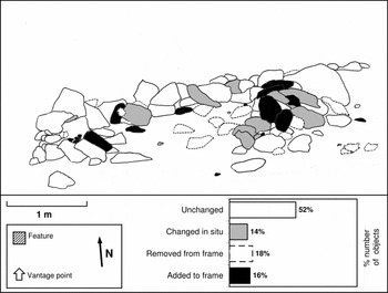
Repeat photography shows that a number of subtle changes in the structure took place between the 1984 and 2006, even though the structure's basic frame remains mostly intact (Fig 15). In the ‘after’ photograph rocks in and around the wall have changed their location and spatial orientation; ceramic pot fragments have been removed; and a lower ground surface within the structure is apparent. An on-site surface examination discovered a range of exposed artefacts around this feature, including pottery fragments, two half buried leather soles, coal fragments, a barrel hoop and other metal fragments. Also found at the site, adjacent to a whale vertebra, were two wooden beams and two plastic fragments with lettering. These were interpreted to be what was left of an interpretation or protection sign.
Overview of changes at the sealers shelter at Cuatro Pircas, Fildes Peninsula, King George Island, Antarctica between 1984 and 2006. Sketch based on 1984 photograph. Sketch by author. Key: white = no changes; grey = changes within the frame; dashed line = removed from frame; black = added to frame.

As other sealing sites in the region, this site was likely to have been occupied early in the 19th century, possibly for a relatively short time only, and then has been abandoned ever since, albeit subject to a range of continuous and episodic processes of transformation. Cuatro Pircas was subject to an archaeological excavation in 1984, immediately prior to which the ‘before’ photograph was taken (R. Stehberg, personal communication, 4 October 2007). This research activity would account for the removal or changes in the location of individual rocks, the apparent reconstruction of parts of the structure, and the removal of ceramic artefacts. In addition, the lower level of the ground surface may be a result of a partial backfilling of the sandy soil after the excavation. Stehberg and others (Reference Stehberg, Pearson, Zarankin, Senatore, Gatica, Barr and Chaplin2008: 87) note that the site is ‘. . .exposed to wind, snow loads, and the activity of seals and human visitors.’ Fur seals roam about and within Cuatro Pircas’ structures and their activities could flatten the dry wall enclosures. Artefacts on the ground surface may have become exposed with the development of a lag deposit (or desert pavement) by effect of wind action, which removes finer particles and leaves behind coarser particles (Schiffer Reference Schiffer1987; Campbell and Claridge 1989).
Fildes Peninsula is now one of the most developed ice free areas in the Antarctic, with four year-round stations, a hard rock airstrip, increasing levels of tourism and non-governmental activity (Pfeiffer and others Reference Pfeiffer, Buesser, Mustafa and Peter2007), and ‘cross-pollination’ between different types of operators (Bastmeijer and Roura Reference Bastmeijer, Roura, Bastmeijer and Koivurova2008). The sealing sites are little known and have low visibility (Stehberg Reference Stehberg, Barr and Chaplin2004: 71), which in this dynamic context makes them particularly vulnerable. Discussions have been underway since 2004 to establish a management regime for the Fildes Peninsula area (see for instance Brazil and others 2006). However, Cuatro Pircas and other sealing sites were not included in any debate on the management of Fildes Peninsula up until 2007. The sites were apparently unknown even by people with an extensive knowledge of Fildes Peninsula (for instance, Pfeiffer and others Reference Pfeiffer, Buesser, Mustafa and Peter2007 do not mention the sites). A management plan for the sites is currently being prepared (Stehberg and others Reference Stehberg, Pearson, Zarankin, Senatore, Gatica, Barr and Chaplin2008: 93). In practice, however, effective protection may still be some years away, as there is substantive disagreement between different stakeholders as to whether the best way of managing Fildes Peninsula is an ASMA, a code of conduct, or other means (see for instance Germany and Chile 2007). The dispersed nature of sealing remains poses further practical difficulties for their protection (see CEP 2007: paragraph 154).
Boatshed at Base A, Port Lockroy, Goudier Island, Antarctica
Base A at Port Lockroy, Goudier Island (64°49′S, 63°29′W), is a historical site and monument described in the designation instrument (ATCM Measure 4, 1995) as ‘[o]f historic importance as an Operation Tabarin base from 1944 and for scientific research, including the first measurements of the ionosphere, and the first recording of an atmospheric whistler, from Antarctica. Port Lockroy was a key monitoring site during the International Geophysical Year of 1957/58.’ The base was closed between 1962 and 1994, during which time it fell into disrepair. In March 1991 the international environmental group Greenpeace visited the site and described it as follows:
The building seems to have been left much as it was when people lived there. The cupboards are stocked with food supplies. The living room is strewn with papers, including weather reports and postage correspondence files, dating back to the late 1950s. . .Outside. . .there was a pile of one hundred completely rusted-out barrels. . .Behind the emergency shed (sic) there was an open rusted drum, which looked like it had been used as a brazier for burning general rubbish (Greenpeace 1991: 21).
In October 1991 the Protocol on Environmental Protection to the Antarctic Treaty was signed. At the time parties agreed that it was desirable for them to implement Annexes I-IV of the protocol pending its entry into force (ATCPs 1991). Early in 1993 Greenpeace revisited the site and reported that it had been partly cleaned up, in compliance with Annex III of the protocol, although there were ‘. . .substantial quantities of twisted and tangled cooper and steel wire lying around the site, with three penguin carcases entangled around it’ (Greenpeace 1994: 102). (The activists summarily packed the wire in boxes and stored them inside one of the buildings (personal observation 31 January 1993)). Between 1995 and 1996, following a conservation survey, Base A was restored. In addition, in 1995 Base A was designated as HSM 61. Since November 1996 the station has been open to tourists and visitors during the summer season (BAS 2001). Base A operates as manned ‘living museum’. It has a gift shop and runs a busy post office ‘. . .on behalf of the government of the British Antarctic Territory which donates a proportion of the post office revenue to the Trust. . .Around 70,000 cards are posted each year for over 100 countries’ (UKAHT undated).
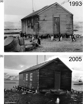
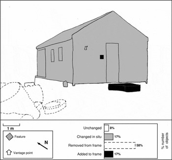
Unlike the other case studies, this one was based on ‘mining’ various sources for information rather than recent fieldwork. The ‘before’ photograph was taken by the author in 1993, and the ‘after’ photograph, dating from 2005, was found on the World Wide Web (Fig. 16). In 1993 the boathouse was apparently sound although weathered. By 2005 all fuel drums had been removed; the building has been painted and a wood and concrete pad added in front of its entrance; and a plaque by the door identifies the building as part of a historic site (Fig. 17). There are still penguins about the site, despite the increase in tourism, tourism visits have not caused a decline in penguin population at this site (Cobley and others Reference Cobley and Shears1999). Both the ‘before’ and ‘after’ photographs show the masts of a sailing vessel standing behind the boathouse, suggesting ongoing visitation by yachts. In addition, a cruise ship is visible in the background of the ‘after’ photograph. These details illustrate the well known expansion of tourism in the Antarctic since the early 1990s. Port Lockroy has become one of the most visited sites in Antarctica, receiving over 15,000 visitors in 2004–2005, up from about 2,000 visitors in 1992–1993. More recent data reveal a continued growth (over 18,000 visitors in 2008–2009). Through its remarkable transformation from an abandoned base to a historical site frequented by tourists Port Lockroy illustrates the linkages between environmental protection, heritage conservation, tourism management, and the assertion of territorial claims.
a-b. Boat house of Base A at Port Lockroy in 1993 and 2005. 1993 photograph by author. 2005 photograph by © Eco-Photo Explorers (www.ecophotoexplorers.com/AntarcticGallery.asp, accessed April 2009. Reproduced with permission).

Overview of changes at the boat house Base A at Port Lockroy, Goudier Island, Antarctica, between 1993 and 2005. Sketch based on 1993 photograph. Sketch by author. Key: white = no changes; grey = changes within the frame; dashed line = removed from frame; black = added to frame.

Discussion
Overview: Site-specific changes
Historical sites in Antarctica and Svalbard may appropriately be described using the term palimpsest. In its original usage ‘palimpsest’ refers to pieces of a scroll or a book in which the original text has been scraped off so that the writing media could be reused. In archaeology and related disciplines this term is used to describe ‘. . .a superimposition of successive activities, the material traces of which are partially destroyed or reworked because of the process of superimposition’ (Bailey Reference Bailey2007: 203). In this research time-serial changes were observed in the seven photo couples that were examined, and which corresponded to the most recent changes of an evolving palimpsest (Table 4). Plainly the analysis assessed obvious macroscopic changes, most objects in a historic site would have changed somehow over time by effect of, for instance, chemical or microbiological processes, but those changes may not be apparent in photographs such as those used here. Only the most conspicuous changes were detected, and mostly in objects located in the foreground of the photographs. Small objects moved around within the frame; others disappeared from or were added to the frame. Apparently random arrangements of objects were modified so that, for instance, objects were aligned, stacked, or put in display. Some large features were restored or reconstructed and others features were created.
Barring a feature that had fallen due to the wind and had been subsequently restored, no feature degraded significantly during the monitoring period. Rather, the condition of several features improved outwardly as a result of conservation actions. This assessment only describes the changes as observed; it does not evaluate whether these changes had positive or negative effects on, for instance, the site's historical values or authenticity. However, assessing and explaining changes to historic features is a first step towards identifying and managing undesirable effects.
The interpretation of changes was made on the bases of photographic material and additional site information. However, it may be difficult to link causes and effects of site transformation. The term ‘equifinality’ describes the process of reaching the same final state from different initial conditions and in different ways (Lyman Reference Lyman, Munro and Bar-Oz2004). For instance, an artefact may have broken as a result of any of a number of processes such as wind, freezing water, a footfall, but these may not always be identified when the only evidence is a broken artefact, or its photograph. In the features examined here cultural processes had more obvious effect than natural processes. Some changes were interpreted to result almost certainly from activities such as trampling, cairn building, stacking or storing of objects, building, and waste removal. These activities are associated with conservation and other forms of active management and, in some instances, with organised tourism. The natural process that had most likely caused changes to some of the historic features discussed here was wind action, and in one case animal activity.
Whatever the immediate and proximal causes of change to individual sites, features, and artefacts, changes as assessed here reflect the broader context in which the sites have been used and managed in the recent past. The transformation of historical sites in Antarctica and Svalbard occurs in the context of recent developments in these regions. For instance, a stone in a cairn reflects a specific event, for example a visitor spontaneously placing a stone in a certain place. The cairn itself reflects a succession of such events. These changes, however minor or ephemeral, take place in the context of expanding polar tourism. Key regional developments of the recent past will be briefly reviewed below.
The regional context of local changes
Many historical sites in the polar regions look like abandoned places, yet they have become an arena in which contemporary activities take place in juxtaposition to historic features, which serve as background. Historical sites in Antarctica and Svalbard were formed by behaviour in past cultural systems and were at some point abandoned. Many sites remained abandoned for years or decades until they were subsequently relocated, while others remained within reach of visitors or were re-occupied. Some sites have been (and in some cases still are) the objects of archaeological or historical research. However, many sites are now part of a contemporary cultural system that determines how the sites are used and maintained. Present day site use (for instance conservation or tourism) usually differs with the original use (for instance research or whaling). Nevertheless, the past may still be an essential component of present day activities through, for instance, the use of material remains as tourism attractions, or narratives about historic events (Roura Reference Roura2009). Conceptually, this situation can be usefully described using the notions of systemic context and archaeological context developed by Schiffer in 1972:
Systemic context labels the condition of an element which is participating in a behavioral system. Archaeological context describes materials which have passed through a cultural system, and which are now the objects of investigation of archaeologists (1972: 157).
As noted previously, historical sites in Antarctica and Svalbard are protected by environmental legislation. In Svalbard the main criteria for protection is age, while in the Antarctic it is recognised historical significance. Additional criteria specific to each region apply to certain remains that do not meet these basic criteria but that nonetheless merit protection. The legislation balances sometimes uneasily the protection of both the natural environment and of the tangible cultural heritage. On the basis of this protection framework, active conservation efforts of historical sites have increased in both regions in the past decades, in parallel with environmental management, and these are apparent in several of the case studies presented here. Conservation efforts are mostly government supported but also point towards an emerging heritage sector. Conservation criteria differ both between and within regions. For instance, historic huts in the Ross Sea are conserved with a philosophy that determines that intervention may be substantive in some instances ‘. . .with major repairs where necessary, and the possible future replication of some elements to preserve the overall ambiance of the hut’ (NZAHT 2004: 10). This contrasts with the approach taken in Svalbard where many more sites are protected than in Antarctica, many of which are in principle left to ‘die in beauty’. This concept means ‘. . .passive preservation, letting nature take its course without interfering in order to prevent decay’ (Prestvold Reference Prestvold2003: 11). Nevertheless, some historic sites in Antarctica are essentially unmanaged; and conversely, some, but certainly not all, high priority sites in Svalbard are actively preserved (Governor of Svalbard 2000). Overall, conservation has not been free of controversy and in some instances may be regarded as a significant factor of site transformation, but underscores the importance assigned to historical sites in both regions.
Archaeological research in Antarctica and Svalbard predates the period discussed here, but it has been a dynamic endeavour in the recent past (see for instance Harrowfield Reference Harrowfield2005 for the Antarctic and Jørgensen Reference Jørgensen2005 for Svalbard) and has more recently been boosted by the International Polar Year 2007–2009. Excavation and sampling standards are higher now than they were in the past, on account of the legal and institutional arrangements that have emerged, but the challenge remains of how to promote research while ensuring the sustainability of the archaeological resources. Jørgensen (Reference Jørgensen2005: 60) has made this point for Svalbard, but it is equally applicable to the Antarctic. A conservative or, perhaps, precautionary approach is needed for the management of archaeological resources in these regions. Apart from archaeology and related disciplines, scientific research and logistics at or near historic sites may also contribute directly or indirectly to the transformation of those sites. This may occur through inadvertent damage, infrastructure development, and (historically at least) souvenir collection (for examples see Harrowfield Reference Harrowfield2005; NZAHT 2004; Stehberg and others Reference Stehberg, Pearson, Zarankin, Senatore, Gatica, Barr and Chaplin2008). Overall, the theoretical argument over these sites will only increase in intensity as various processes, such as tourism and climate change, continue to degrade these sites and diminish their value to historical scientists.
The first tourism cruise to Spitsbergen was organised in 1871 (Conway Reference Conway1906: 302) while organised tourism in the Antarctic Treaty area began in the 1950s (Headland Reference Headland1994: 275). However, the 1990s marked an inflection point in which tourism began to increase significantly and became eventually a major presence (Viken and Jørgensen Reference Viken and Jørgensen1998; Bastmeijer and Roura Reference Bastmeijer and Roura2004; Kolltveit Reference Kolltveit2006). Svalbard's tourism expansion resulted in part from government policy (Viken and Jørgensen Reference Viken and Jørgensen1998), and consequently it has been somehow regulated from the start through a combination of state regulation and industry guidelines. Further stringent restrictions on tourism at key cultural heritage sites have recently been discussed (Governor of Svalbard 2009). Antarctic tourism has developed more spontaneously and has been only subject to certain conditions rather than to actual restrictions (Bastmeijer and Roura Reference Bastmeijer and Roura2004). This is only recently starting to change following several shipping accidents involving tourism vessels, including the sinking of the MV Explorer in November 2007. Tourism management at Antarctic historic sites combine generic and site-specific regulation, both binding and non-binding, which emerges from Antarctic Treaty states and from the industry itself. By and large historic sites in Antarctica and Svalbard are protected and managed for the values they represent, and tourism is a result of conservation than rather than its primary objective. However, a small number of historical sites, by design or by coincidence, have been modified for tourism consumption, notwithstanding their historic significance.
Historical sites have geopolitical interest through their uses to assert (or deny) territorial claims. Despite the international agreements that regulate the governance of Antarctica and Svalbard, and which settle or set aside the sovereignty discussion, issues of claims and jurisdiction are still part of regional politics (see for instance Jacobsson Reference Jacobsson, Triggs and Riddell2007; Pedersen Reference Pedersen2009) and rituals and symbols of possession (Seed Reference Seed1995) continue to be played out in both regions. While earlier ritual activities concerned the placement of infrastructure such as bases, huts, and mining works, some of today's historic sites, in the present rituals concern primarily the protection and management of these and other kinds of sites (Roura Reference Roura, Barr and Chaplin2008b). Material symbols of presence displayed at historic sites may include memorials, monuments, flags and flag masts; visitor management infrastructure such as huts, paths, and interpretation or regulatory signs; and added attractions such as souvenir shops or postal offices. These symbols project an image of presence and effective administration; and in some instances favour some narratives of historic events at the expense of others (for instance, Roura Reference Roura2009). Tourists and other visitors provide an audience to these rituals and symbols and take them home as they record their visit with photographs, films, or post cards.
Rapid climate change is apparent in the Arctic and in parts of the Antarctic with consequential effects on historic sites (ICOMOS 2008; Barr Reference Barr, Petzet and Ziesemer2008). Generally, the effects of climate change in the polar regions may affect both the landscape and the historic sites it contains. Elements designed for the cold or preserved in cold conditions deteriorate rapidly with a warming of the environment. Additional changes to historic sites may result indirectly through the warming of the polar landscape (ICOMOS 2008). Effects may include the erosion of coastal sites, increased forms of biological decay, and increased tourism penetration (Barr Reference Barr, Petzet and Ziesemer2008). These pressures may in turn intensify the need for actions to ensure the long-term preservation of historic sites.
Conclusions
Historical sites in Antarctica and Svalbard contain the material remains of past activities of exploration and exploitation of these regions. These sites are subject to continuing transformation by cultural and non-cultural (natural) processes since their abandonment to the present. The sites are significant for the historical and other values they embody, and for research and management purposes it is important to assess and explain the changes they experience. In this research the status and change of seven historic features in Antarctica and Svalbard was monitored by means of repeat photography.
Recent time-serial changes were observed in the seven photo couples examined here. Many minor and some major additive, reductive and in situ changes occurred at the seven historic features. In most cases the changes did not affect negatively the condition or integrity of individual features; rather, the deterioration of several features was stopped or reversed. Whether or not the changes affect the historical values of the sites is in some cases the subject of controversy.
Some changes were interpreted to result from cultural processes, primarily conservation and other forms of active management; archaeological research; and organised tourism. Natural processes, particularly wind action, caused further changes. The ongoing conservation of the features discussed here may be an artefact of their relatively accessibility and of their recognised historic significance. In contrast, many other historic sites in Antarctica and Svalbard are essentially unmanaged and evolving towards their eventual destruction (for instance, Barr and others Reference Barr, Lüdecke, Olynyk, Truscott, Petzet and Ziesemer2005; Arenz and Blanchette Reference Arenz, Blanchette, Barr and Chaplin2008).
Narratives about some historic sites in the polar regions emphasise the notion that these sites are largely ‘time capsules’ that have remained untouched over the years since the last occupants left. This is reinforced by some interventions that aim to reproduce specific periods of the sites’ past. However, sites reflect traces of ongoing events over the years, and can be regarded as part of an evolving palimpsest. Historical sites participate in the behavioural system of contemporary activities in Antarctica and Svalbard (in the systemic context of Schiffer Reference Schiffer1972) and are the focus of multiple contemporary interests and activities largely centred on the historical character and values of the sites. Local processes of change may be linked to regional developments, which are likely to have had an indirect effect on many of the sites discussed here, and in some instances have been significant drivers of site transformation. The evidence presented here suggests that historic sites in the polar regions are dynamic entities that not only reflect the past as it once was, but that are also a window onto the present.
Acknowledgments
My thanks for their help to produce this article go, without implicating them in my interpretations, to the following people and institutions. Professor Louwrens Hacquebord and Dr. Maarten Loonen (University of Groningen, Arctic Centre) facilitated my fieldwork at the Netherlands Arctic Station and elsewhere in Svalbard, helped to develop this research, and reviewed this article. Some basic ideas about site monitoring emerged from discussions with Dr. Susan Barr (Norway's Directorate of Cultural Heritage) and Per Kyrre Reymert (Government of Svalbard). On Antarctic matters I benefited from discussions with Jim Barnes, Dr. Kees Bastmeijer, Ambassador Jorge Berguño, and Dr. Alan Hemmings.
I am grateful to the various institutions and individuals that invited, funded, transported, hosted or otherwise enabled me to travel to the Antarctic and Svalbard repeatedly and to conduct fieldwork there. These include the Instituto Antártico Argentino, Greenpeace, the Antarctic and Southern Ocean Coalition, and Gateway Antarctica, University of Canterbury. Fieldwork in Svalbard was funded by the Groningen Institute of Archaeology, University of Groningen. Particular thanks to Gary Evans, Per Kyrre Reymert, Dr. Michelle Rogan-Finnemore, Dr. Hans-Peter Ulrich, Base Decepción staff (2001–2002), Oleg Sakharov and Bellingshausen base staff (2005–2006), and Scott base's Antarctic field team (2007–2008). Reaching specific sites was made easier with the assistance or company of Wolfgang Dinter, Wojtek Moskal, and Steffen Vogt. Grete Marstein kindly acted as Norwegian interpreter when interviewing mining veterans.
Photographs supplementing my own collection were kindly provided by Dr. Antonio Bendala, the Governor of Svalbard, Professor Hacquebord, Dr. Loonen, Dr. Rubén Stehberg, and Christopher Weaver and Mike Salvarezza. Finally, I thank Janet Dalziell and two anonymous reviewers for their valuable criticism of earlier versions of this article.