Introduction
My career in Libyan archaeology has followed a ‘less travelled road’, focused on Libya's vast rural spaces, though as in Frost's famous poem one may wonder if the choice was quite as self-deterministic (or as pre-ordained) as at first glance appears (Frost Reference Frost1971, 77). The career path is so much easier to make sense of in retrospect! My initial encounter with Libyan archaeology came in 1979, 10 years after the foundation of the Society. A first visit to Lepcis Magna was an event that defined my life and subsequent career. The mercurial English football manager Brian Clough once famously stated: ‘I wouldn't say I was the best manager in the business. But I was in the top one’ (https://www.theguardian.com/football/2004/sep/20/newsstory.sport10). Lepcis Magna is in my ‘top one’ of ancient sites, but, perhaps curiously, my long-term research focus has not been on the magnificent Classical cities of Libya (though I have had some engagement with urbanisation at the ‘little Lepti’ in Tunisia – see Stone et al. Reference Stone, Mattingly and Ben Lazreg2011).
There are a number of factors to explain why I took the road less travelled. In the post-Second World War period, the Italian archaeological missions had continued to dominate the investigation of the Greco-Roman cities of Mediterranean Libya. This extraordinary body of work has been very much focused on the monumental and amazingly preserved edifices at these sites, with extensive restoration projects that have come to define the academic and public image of ‘Roman archaeology’ in Libya (di Vita et al. Reference Di Vita, Di Vita-Evrard, Bacchielli, Golvin and Polidori1998). There have been a few interventions by British researchers at these celebrated sites – notably when Richard Goodchild was Controller in Cyrenaica in the early 1960s (Goodchild Reference Goodchild and Reynolds1976) or when J.B. Ward-Perkins and Kathleen Kenyon were active at Lepcis Magna and Sabratha in the 1950s (Kenrick Reference Kenrick1986; Ward-Perkins Reference Ward-Perkins and Kenrick1993). More recently the Society's important work at Benghazi and Euesperides has involved stratigraphic excavation of non-monumental structures (Lloyd Reference Lloyd1977; Wilson Reference Wilson, Fabbricotti and Menozzi2006). In general, though, the work of British Classical archaeologists has tended to focus on Libya's vast rural and desert spaces (Brogan and Smith Reference Brogan and Smith1984; Goodchild Reference Goodchild and Reynolds1976; Daniels Reference Daniels1989). It was in their footprints that I followed and as Frost observes ‘knowing how way leads on to way, / I doubted if I should ever come back’.
Two other big influences on my early career steps must be mentioned. The first was my PhD supervisor Barri Jones, who directed my attention to understudied questions relating to the Roman frontiers in North Africa and gave me the opportunity to work on the UNESCO Libyan Valleys Survey, which he co-directed with Graeme Barker. Graeme opened my eyes to the methodologies and agendas of landscape archaeology and helped broaden my interests to life in the frontier region beyond the military installations. It quickly became apparent that the greatest obstacle to understanding the impact of the Roman Empire in Libya was the almost total lack of development of Iron Age archaeology there. Elsewhere in the Maghreb, the Protohistoric era, as it is called, was primarily known through burial monuments (Camps Reference Camps1961). While my job title today is ‘Professor of Roman Archaeology’, I would like to think that some of my most important contributions have been in advancing the study of the Protohistoric archaeology of Maghreb and Sahara.
My Libyan journey proper in many ways started in the Libyan pre-desert and led me in a sequence moving further and further into the Central Sahara, eventually connecting up with other desert regions beyond Libya. The order of presentation here follows that journey, which is at the same time a personal one and a record of a series of important interventions in Libyan archaeology involving the Society. At a rough count, these various projects have involved the participation of over 200 individuals, both Libyans and researchers from Britain and many other countries. Among my PhD students, 13 have completed projects on North African topics. The roll call of results I shall present in this paper is very much a shared credit across these teams and individuals. This has in consequence become a well-trodden research path for the Society's work in Libya. In what follows I cite only a selection of published work that provide entry points to the detailed bibliography. While my work has been primarily focused on Western and Southern Libya, I have also directed projects in Eastern Libya, Tunisia and Morocco (see Mattingly et al. this volume).
A prime focus of the article is to assess the results and significance of this body of work in terms of rural settlement patterns, the nature of indigenous societies, desert lifestyles and economies. In the broader context of North African archaeology I would argue this has been an influential contribution, opening important windows on the lives of ancient Libyan peoples beyond the immediate purview of the Classical cities (see Mattingly Reference Mattingly1989, for an earlier review in the Society's 20th Anniversary year; Mattingly and Hitchner Reference Mattingly and Hitchner1995, for a broad historiographic and thematic review of the state of the field 25 years ago as a base of comparison).
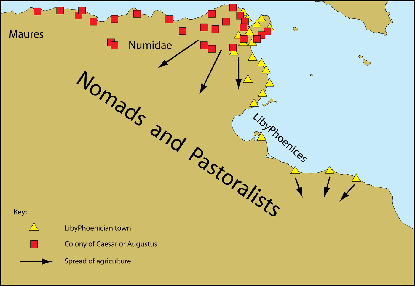
Until relatively recently, much orthodox academic opinion followed a strongly colonialist line, arguing that the ancient indigenous societies were pastoral/nomadic peoples, primitive, under-developed and unremarkable. The colonialist model presented things like the spread of agriculture and urbanisation as essentially due to outside intervention (Figure 1). Innovation and advances in technology were thus attributed to colonists (the legacy of this approach is still evident even in the most recent authoritative account of Roman Africa, Lassère Reference Lassère2013). It is small wonder that modern Libyans have felt disassociated from the achievements of their pre-Islamic predecessors (Mattingly Reference Mattingly2011, 43–72 is a detailed deconstruction of the colonial and neo-colonial agendas). Our perceptions of indigenous North Africans have been transformed in the last 50 years, in large measure due to the Society's projects. There is now much to celebrate about the way ancient Libyans created complex and technologically advanced societies in desert and arid landscapes.
The traditional colonialist model of North Africa as an underdeveloped land inhabited sparsely by nomads prior to the establishment of Phoenician and Roman colonial settlements and the spread of agriculture from their territories (from Mattingly Reference Mattingly, Mugnai, Nikolaus and Ray2016).

The Libyan Valleys Survey (1979–1989)
The UNESCO Libyan Valleys Survey (ULVS) entailed a ground-breaking interdisciplinary study of an area of c.75,000 sq km in the Tripolitanian pre-desert. More than 30 interim or specialised reports were published, many in Libyan Studies between 1980 and 1995, along with a two-volume final report (Barker et al. Reference Barker, Gilbertson, Jones, Mattingly and Barker1996a/Reference Barker, Gilbertson, Jones, Mattingly and Mattinglyb, winner of the AIA James Wiseman Award). The results built on pioneering exploration of key classes of fortified sites (qsur) and monumental mausolea carried out by Goodchild and Brogan, but the ULVS also greatly expanded knowledge of the associated floodwater farming systems, the range of sites in the settlement hierarchy, the chronological precision of phases of their development, their palaeoecology and above all our understanding of the nature of the society responsible for the ‘greening of the desert’ in the early centuries AD.
Research highlights
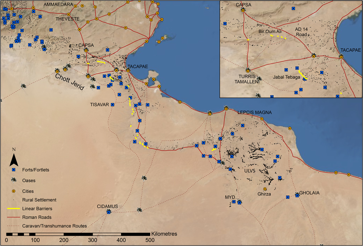
A vast dossier of data, spanning a range of disciplines, was collected (Figure 2) and among the major results I highlight:
• The documentation of a phase of sedentary settlement that pre-dated the previously identified Late Roman fortified farms. The character of some of the late first to second century undefended sites echoed the architecture (in opus africanum) of the olive farms of the Gebel Tarhuna.
• The pre-desert farmers were demonstrated to have been sedentarised Libyan people, rather than settlers from outside the region.
• The palynological record, the botanical remains and the faunal analyses revealed a largely sedentary farming regime that operated in a challenging environment, similar to that of the present day.
• In a region of low and erratic seasonal rainfall, the irrigation technology employed involved careful direction of the periodic floodwaters into field systems laid out in the valley (wadi) bottoms.
Map of Tripolitania showing the Roman frontier installations and the dense pre-desert settlement recorded by the ULVS (from Mattingly et al. Reference Mattingly, Rushworth, Sterry and Leitch2013a).

Tripolitania and Roman Libya
The ULVS work also underpinned my PhD thesis research on the wider region of Tripolitania overall (awarded in 1984, then substantially revised as Mattingly Reference Mattingly1995). This brought together the ULVS results, with my broader analysis of the Roman frontier installations, plus urban centres and communications, rural settlement, economic activity and cultural change in both north-west Libya and south-east Tunisia (which together formed the late Roman province of Tripolitana). While the book did not neglect the major cities, these were not the conventional centrepiece of the narrative, which instead set out to explore the military, economic, cultural and environmental context in which they flourished. Work on the archaeology of the broader region had made me aware of some extraordinarily large olive oil production sites in the hinterland of the coastal cities and discoveries of numerous press facilities by the ULVS in the pre-desert further stimulated my interest in researching more deeply the technology and economic implications of oil and wine presses. I had the good fortune to be awarded a British Academy Post-Doctoral Fellowship to pursue this research, which allowed me to re-evaluate the scale of olive oil production and the olive oil trade in northern Tripolitania (Mattingly Reference Mattingly1988a/Reference Mattinglyb; Reference Mattingly1995, 138–59).
I was subsequently responsible for the compilation of the series of maps covering Tripolitania, Sirtica, Fazzan, Cyrenaica and Marmarica/Siwa for the Barrington Atlas (Talbert Reference Talbert2000, maps 35–38 and 73), which enhanced my knowledge of Roman Libya as a whole. This work has subsequently been developed for the Society by Charlotte Roueché and the KCL Digital Laboratory as the Heritage Gazetteer of Libya (http://www.slsgazetteer.org/).
Research highlights
• A key aspect of my book on Tripolitania (Mattingly Reference Mattingly1995) was to change the nature of debate regarding the cultural make-up of the region's population, especially in the rural communities, and their contribution to Tripolitania's distinctive cultural character. I emphasised the continuing significance of Libyan and Punic culture in the Roman period and of local meanings underlying Roman symbols, especially outside the cosmopolitan major cities.
• I highlighted a number of indications of socio-economic development among the region's indigenous population, especially sedentarisation.
• My attempts to quantify the productive capacity of traditional presses and to estimate the overall productive regional productive capacity (Mattingly Reference Mattingly, Amouretti and Brun1993; Mattingly and Hitchner Reference Mattingly, Hitchner, Amouretti and Brun1993) have been expanded on in the PhD theses of four of my students (Ahmed Reference Ahmed2010; Reference Ahmed2019; Buzaian Reference Buzaian2019; Hobson Reference Hobson2012; Reference Hobson2015; Zocchi Reference Zocchi2019. Other PhD studies have also had a strong focus on the economic drivers in the North African provinces, Abdulhamed Reference Abdelhamed2018; Abdrbba Reference Abdrbba2018; Emrage Reference Emrage2015; Hesein Reference Hesein2014; Leone Reference Leone2001).
• Olive oil is demonstrated to have been a fundamental contributor to the wealth of the region's leading families and to the magnificent adornment of coastal cities like Lepcis Magna.
• The book emphasised that the apex of the region's fortunes was not due to a climatic optimum, but rather achieved despite the generally challenging environmental conditions and that it owed much to local adaptation, ingenuity and involvement, rather than to exogenous forces.
• Understanding of the Roman frontier (Figure 2) has also changed due to improved knowledge of indigenous society in the frontier zone (see now Mattingly Reference Mattingly, Rushworth, Sterry and Leitch2013a, for an updated interpretation of the frontier).
The Fazzan Project (1997–2002)
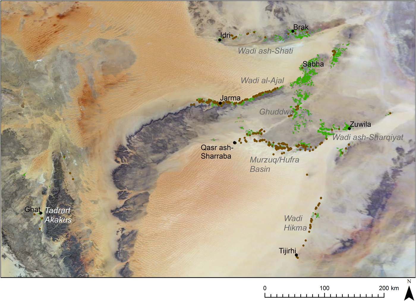
In the late 1990s I was appointed to lead a new Libyan Society expedition to investigate the Garamantes of the Central Sahara. The Garamantes were a notorious group, featuring in Roman sources as the archetype of desert barbarians. The Fazzan Project was a much needed follow up to extraordinary initial work between 1958 and 1977 by Charles Daniels (see Daniels Reference Daniels1989 for a summary article on his work). The picture of Garamantian society revealed by Daniels was at odds with the pessimistic and derogatory verdict of the Greco-Roman sources. But his evidence gathering was far from complete when his fieldwork ended abruptly in the late 1970s and he did not fully publish his findings prior to his sudden death in 1996. Through a combined programme of excavation at the Garamantian capital of Garama (Old Jarma) and more widespread survey of their settlements, cemeteries and irrigation works (notably underground canals called foggaras), the Fazzan Project (1997–2002) was able to fill in many gaps, identifying for the first time a high density of sedentary settlements – most commonly villages and hamlets – along their heartland valley of the Wadi al-Ajal, a linear depression sandwiched between a towering sand sea to the north and a sheer escarpment rising to the south (Figure 3). The results of the project (bringing together both new fieldwork and the unpublished fruits of Daniels work) were published in 15 articles and papers, many in Libyan Studies between 1997–2004, and in four printed volumes, presenting The Archaeology of Fazzan (Mattingly Reference Mattingly2003; Reference Mattingly2007; Reference Mattingly2010; Reference Mattingly2013; now all available on open access via the Society's website http://www.societyforlibyanstudies.org/open-access-ebooks/). Volume 1 presented an overall synthesis of the new information, with Volume 2 comprising a gazetteer of sites of different types, including preliminary work on rock art by Tertia Barnett, arranged by survey sectors, plus a first suite of radiocarbon (AMS) dates, a pottery type series and other finds’ catalogues relating to the survey. Volume 3 was given over to a full publication of a number of excavations undertaken by Daniels and Volume 4 to the survey and excavation of the complex urban sequence recorded at the key site of Old Jarma.
Map of Fazzan, southern Libya, showing the extent of Garamantian settlements (from Sterry and Mattingly, Forthcoming).

Research highlights
• The Garamantes now emerge from the shadows – they are by far the best studied example of an ancient Saharan people and also the group who can most cogently be argued to have created the first urban sites and state structures in the Central Sahara.
• The first traces of their civilisation date to the early first millennium BC, initially focused on hillforts like Zinkekra, but from the outset associated with oasis cultivation of date palms, wheat, barley and other crops.
• The extent and scale of their underground irrigation canal systems (foggaras) have been mapped and evaluated. There is an AMS date from one example, indicating its construction as early as the fourth to third centuries BC.
• The occupation at Jarma also dates back to the fourth century BC and initiated a long sequence of superimposed proto-urban and urban oasis settlement.
• The detailed artefactual and palaeoeconomic records from the well-dated stratigraphic sequence illustrate that the Classic Garamantian era (first to fourth centuries AD) marked the heyday of the site and close trading relations with the Roman empire, with Medieval and early modern levels revealing a much impoverished centre.
• The overall distribution of ‘Garamantian’ cultural markers (foggaras, diagnostic settlement and tomb types, funerary furniture, common Roman imports, etc.) encompasses the three major oasis bands of Fazzan (Figure 3) – the Wadi ash-Shati, the Wadi al-Ajal and the Murzuq depression, with outlying smaller clusters of sites in the Wadi Tanzzuft (south-west), Wadi Hikma (south-east) and Sabha area (north-east).
• The work of the Fazzan project also heralded a broader renewal of work sponsored by the Society on the history, archaeology and environment of the Libyan Sahara (Mattingly et al. Reference Mattingly, McLaren, Savage, al-Fasatwi and Gadgood2006).
The Desert Migrations Project (2007–2011)
I was the PI on the Society's follow-up to the Fazzan Project. The Desert Migrations Project (DMP) comprised a portfolio of sub-projects with individual leaders under a broad umbrella focused on diachronic evidence for population movement and changing Saharan society from deep prehistory to the recent past. Once again the results have featured in more than 20 articles in Libyan Studies and other journals between 2007–2013. Rob Foley and Marta Lahr led a mixed geo-archaeological research group investigating the evidence for the earliest hominins and humans in the Central Sahara in relation to cyclical changes in the environment, climate and hydrology (see Lahr, this volume). Tertia Barnett now expanded on her initial rock art survey to carry out a detailed ‘boulder by boulder’ record of a stretch of the Wadi al-Ajal. Stephania Merlo extended the search for the Garamantes into the northern valley of Fazzan, the Wadi ash-Shati and a small sub-group under my leadership carried out initial survey of sites in the Murzuq region in the southern oasis belt of Fazzan, adding significant detail to the evidence of Garamantian activity in those regions. My team also made an intensive survey of two areas of escarpment cemeteries, foggaras and oasis settlements in the Wadi al-Ajal, between Zinkekra and the Royal Cemetery south of Old Jarma and around the Taqallit headland about 30 km west of Jarma. However, the main focus of my team in this phase was excavation of a series of Garamantian cemeteries in the just mentioned areas, to examine a sample of different tomb types and to conduct detailed analysis of the human remains recovered, so as to build a demographic picture of Garamantian society, its stature, lifestyle and pathologies.
Research highlights
• Some of the main outcomes of the Desert Migrations Project have been delivered as part of the work programme of the Trans-SAHARA project (see below) and through the work of another PhD student (Gonzalez Rodriguez Reference Gonzalez Rodriguez2014).
• Despite our inability to complete all the finds study and post-excavation envisaged due to the impact of the 2011 civil war, significant new knowledge has been established on the dating of tombs through the use of AMS (Gatto et al. Reference Gatto, Mattingly, Ray and Sterry2019, 73–76). New details have been documented about funerary rites and grave assemblages, enhancing understanding of changes over time and age and gender related differences (Gatto et al. Reference Gatto, Mattingly, Ray and Sterry2019, 79–100).
• Integrated methods of palaeobiological analyses have revealed significant diversity and signs of mobility in the Garamantian population (Nikita et al. Reference Nikita, Mattingly and Lahr2012; Reference Nikita, Mattingly, Lahr and Kotlia2013; Power et al. Reference Power, Nikita, Mattingly, Lahr and O'Connell2019). Although core characteristics can be identified for the Garamantes overall, in many cemeteries examined there was a significant minority (25–30 per cent) who had morphometric or isotopic differences (reflecting differences in diet or water at some stage in life). Migration, thus, does appear to have been a significant aspect of Garamantian society.
• The rock art of the Wadi al-Ajal has been published in exemplary detail and with cutting-edge analysis (Barnett Reference Barnett2019a/Reference Barnettb).
The Peopling the Desert Project (2010–2011)
In around 2009, the appearance of strips of high resolution satellite imagery on the free-to-view Google Earth site was revolutionary and transformative. Hitherto, imagery of this quality was either unobtainable or unaffordable for archaeologists. In desert regions, where site preservation is often exceptional, the potential of this sort of imagery is particularly high, as many details of the sites can be directly mapped. In a few initial areas where high resolution imagery was released to the east of Murzuq, it was possible to observe a wealth of previously unrecorded sites that were simply not visible on conventional imagery. With funding from the Leverhulme Trust, Martin Sterry and I started mapping these sites and, as described above, we organised a preliminary reconnaissance mission as an off-shoot of the DMP to visit a sample of the sites identified (Sterry and Mattingly Reference Sterry and Mattingly2011). This ground-truthing expedition produced a number of significant results. Firstly we were able to demonstrate from finds of Roman wheelmade pottery at many examples of a distinctive type of fortified site (qsur) that these structures were probably of Garamantian date and not Medieval as we had initially thought from their crisp preservation on the imagery – something we were able to corroborate with a programme of radiocarbon dates (Sterry and Mattingly Reference Sterry and Mattingly2013; Sterry et al. Reference Sterry, Mattingly and Higham2012). We were also able to define and date characteristic sites of Medieval date and to shed light on the dating and development of the early modern urban centre of Murzuq. What is clear for Fazzan is that the Garamantian-era settlement density was extraordinarily high in comparison to the early modern period.
This project was already in transition into the Trans-Sahara project (see below) – which planned to expand the work across a number of Libyan oases – when the Libyan civil war erupted.
Research highlights
• The Murzuq results highlight the sophistication of Garamantian settlement architecture by the third century AD, with the typical settlement site now fortified, with castle-like central buildings that strongly resemble the morphology of late Roman frontier forts (quadriburgi).
• The identification of distinctive Garamantian fortified sites enabled us to go back with more confidence to the site records from the Wadi al-Ajal and, thanks to further AMS dates from samples gathered there, to confirm that both regions had seen extensive building of fortified structures within settlements in the late Garamantian period, broadly third to sixth century AD (Mattingly et al. Reference Mattingly, Sterry, al-Haddad and Bokbot2018).
• While unfortified settlements are hard to detect, even on the high resolution imagery, the distinctive shape and layout of the Late Garamantian fortified villages can now be identified with confidence on the ever expanding volume of imagery.
• Plans of similar aspect from areas of the Sahara further to the west are routinely ascribed a Medieval date, but such assumptions need revisiting now.
The Ghadamis Project (2010–2011)
The opportunity arose in 2010–2011 to conduct a baseline study of the iconic oasis of Ghadamis (ancient Cidamus) as part of a programme of environmental mitigation work being carried out by BP. The World Heritage Site here is very focused on the elegant multi-storey early modern houses, the atmospheric covered alleyways, the major mosques and squares, the evidence for a time-based system of division of the artesian spring-water, etc. Following a desk-top study of the available evidence, a survey was organised early in 2011, though the work was cut short after only a few weeks by the outbreak of the Libyan civil war. This remains unfinished business, but the initial stages of work had demonstrated the potential to illuminate the early phases of the development of the oasis prior to the characteristic early modern buildings and gardens of the World Heritage Site.
Research highlights
• Despite the curtailment of the work, important new evidence has been gathered relating to the early development of Cidamus, including a re-evaluation of a group of prominent ashlar masonry tombs (asnam), which were evidently at the core of a much larger funerary zone than hitherto identified. The architecture of these tombs is very similar to the famous Ghirza mausolea and like those tombs they were decorated with relief sculpture, offering an important window into the world of the Libyan population, interestingly revealing some important differences from the people of the pre-desert zone around Ghirza (see now the PhD research of Nikolaus Reference Nikolaus2016).
• The survey of oasis gardens revealed interesting variability of construction of garden walls and the presence of numerous structures within the gardens.
• Careful mapping of traces of foggaras showed that the spring was supplemented at certain periods by additional irrigation technologies.
• An outlying fortified hilltop site to the north of Ghadames has yielded AMS dates of late antique or early Islamic date.
The Trans-SAHARA Project (2011–2017)
With substantial funding from the European Research Council, my Trans-SAHARA Project sought to combine data from a number of the above projects and allow them to be taken to another level of analysis. In essence this was seen as a way of contextualising the new evidence concerning the Garamantes within a wider framework, encompassing the Sahara and neighbouring territories in the Maghrib, Nile Valley and Sub-Saharan Sahel.
The project was structured around a series of key themes organised within four workgroups:
• Urbanisation and state formation – building on a reassessment of the process of sedentarisation and oasis creation in the Sahara (the main research associate/RA was Martin Sterry);
• Trade – with a particular focus on ceramics and glass, but detailed consideration of organic commodities of trade like textiles (RAs: Victoria Leitch; Franca Cole; Chlöe Duckworth);
• Mobile technologies – exploring the processes of technological invention, adaptation and transmission in the Trans-Saharan world (RAs: Aurélie Cuénod; Chlöe Duckworth);
• Burials, migration and identity – linking the physical structures, with burial and memorialising practices, and with the evidence obtained from analysis of the human remains (RAs: Ronika Power; Nick Ray; Maria Gatto).
Research highlights
The research has led to a large number of published outputs, with some of the key conclusions now appearing in a series of monographs published jointly by the Society and Cambridge University Press. Each volume focuses on one of the workgroups and combines a substantial presentation of the project's results with a selection of specially commissioned comparative studies, authored by other experts in Nilotic, Maghribian, Saharan and West African archaeology. These volumes are thus designed to construct agendas relevant for future study of the ‘ancient Sahara and beyond’, while also allowing alternative perspectives to inform an immediate debate on the data and ideas. A key feature of the volumes is that they place the Sahara at the centre of the debate, rather than seeing it as a peripheral zone of the Mediterranean or other region.
Volume 1 concerns the origins and nature of Trans-Saharan trade (Mattingly et al. Reference Mattingly, Leitch, Duckworth, Cuénod, Sterry and Cole2017), contesting a still commonly encountered idea that such trade was not properly established before the Islamic age, which saw it reach its apogee. One of the main problems with studying the trade archaeologically is that the bulk of the commodities transported leave little archaeological trace and defy quantification (being typically organic or perishable materials like people, textiles, dates) or valuable exotics (gold and other metals, ivory, semi-precious stones). Large scale carriage of Mediterranean pottery and glass, as we find in the lands of the Garamantes, was the exception rather than the rule (though of course the penchant of the Garamantes for consuming Roman ‘stuff’ is extremely interesting in itself). Modern analytical techniques (especially in relation to metal alloys and glass compositional recipes) are a key to identifying the ‘smoking gun’ from which we may recognise the interconnections across very wide spaces.
The second volume (Gatto et al. Reference Gatto, Mattingly, Ray and Sterry2019) explores the related themes of burial traditions, migration and identity presentation in Saharan societies. Once again, new analysis of the human remains excavated in Fazzan reveals evidence of inter-regional connectivities and considerable diversity in Saharan society – though interestingly this does not always neatly map onto observed ‘cultural’ differences. Although the Garamantes followed some widespread Saharan mortuary traditions, at the same time their society stood out from most other groups in terms of the range and scale of funerary monuments, an emerging preference for rectangular over circular forms of funerary monuments, with richer grave assemblages.
In the third volume (Sterry and Mattingly, Forthcoming), we debate the key issues of sedentarisation, urbanisation and state formation – once again challenging a common belief that these phenomenon were largely absent from the Sahara before the Islamic era and even then very constrained in size and socio-political realities. Simplistic evolutionary models of social development cannot explain the complex and risky process by which oases emerged in different parts of the Sahara (Purdue et al. Reference Purdue, Charbonnier and Khalidi2018). The Garamantes now serve as a strong example of a precocious oasis farming society, with their larger settlements exhibiting urban characteristics and overall meriting consideration as a state by the early centuries AD (though the terms ‘urban’ and ‘state’ need to be considered in relation to Saharan norms, rather than in Mediterranean terms, see also Mattingly and MacDonald Reference Mattingly, MacDonald and Clark2013; Mattingly and Sterry Reference Mattingly and Sterry2013). Other outcomes of the settlement research include hundreds of new AMS dates from historic era sites (Mattingly et al. Reference Mattingly, Sterry, al-Haddad and Bokbot2018; Sterry and Mattingly Reference Sterry and Mattinglyforthcoming), allowing us to author detailed biographies of key Libyan oases, starting with Jarma (Mattingly Reference Mattingly2013) and Zuwila (Mattingly et al. Reference Mattingly, Sterry and Edwards2015), with further studies on al-Jufra and Ghadamis in progress. A detailed overview (Mattingly et al. Reference Mattingly, Sterry and Leitch2013b) of fortified settlements from across Roman Africa and the Garamantian territories questions the long-established default tendency to assume these were military in nature and offers a new morphological classification.
The final volume (Duckworth et al., Reference Duckworth, Cuénod and MattinglyForthcoming) should also appear next year and concerns technological transfers in the Sahara and beyond. Diffusionist models of technological innovation and spread still require careful critique and the volume explores more complex ideas about what technology is and how it is used and disseminated within space and between communities. Key points are that invention can be independent, that technological decisions are most commonly about what is appropriate and that much change relates to minor adaptations of existing technology rather than innovation. The importance of technological analysis for understanding the nature of the societies is also highlighted, as is the need to carefully date the appearance of technologies to determine better the directions in which technology transfer occurred – there is good evidence for some elements moving from east to west (the agricultural package and complex irrigation), but other items (later additions to Saharan crops) seem to have travelled from south to north and west to east. There is also compelling evidence of a significant level of Garamantian manufacturing activity as an essential counterpart to their success in Saharan trade and this was dependent on a range of technologies – textile working, metallurgy, glass bead making, etc.
Conclusion
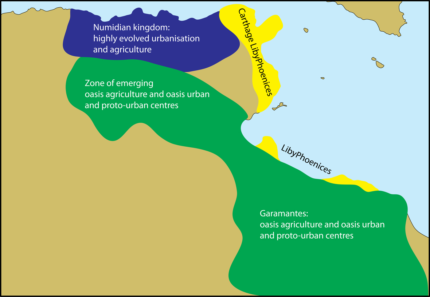
There is no definitive end point of this road, as the journey continues – with the next generation of researchers creating further branching tracks. However, the research landscape is very different today compared to what was known 50 years ago. A fundamental difference is that in exploring Libya's dramatic rural landscapes, we have populated them with numerous historic settlements and gleaned significant knowledge of the lifestyles and culture of the ancient peoples, both pastoralists and sedentarists. However, this is not just a question of putting dots on maps (Figures 2–3); the new evidence has changed the nature of debate about Protohistoric and Roman-era rural society in Libya. The shadow of the desert can now be more clearly perceived in the story of Roman Libya. The old emphasis on exogenous intervention (for which, read Greek, Phoenician and Roman) being solely responsibility for the spread of things like agriculture and urbanism can now be challenged; it is possible to demonstrate an important endogenous contribution to such processes and we can see that the initial stages in these socio-economic transformations pre-dated the arrival of the first Mediterranean ‘colonists’ (Mattingly Reference Mattingly, Mugnai, Nikolaus and Ray2016). In place of the previous model that highlighted only the contribution of incomers, the new evidence emphasises separate but parallel developments at the coast, in the near hinterland and in the deep Saharan hinterland (Figure 4).
An alternative model of Protohistorical developments, based on the new archaeological data showing endogenous socio-economic developments, in which coastal developments of Libyphoenician towns are matched by the Numidae in central and northern Tunisia and by the Garamantes and other oasis communities in the Sahara (from Mattingly Reference Mattingly, Mugnai, Nikolaus and Ray2016).

The Arab Spring and its aftermath have had profound impacts on Libya. First and foremost the human consequences have been devastating and continue to present challenges from day to day for its long-suffering people. Where does archaeology and heritage sit in all this? Undoubtedly, these are some way down the list of key priorities and understandably so. Foreign missions, through initiatives like the Endangered Archaeology or Training in Action projects (see contributions by Hobson and Leone, this volume), have endeavoured to support the Libyan Department of Antiquities respond to rapidly escalating threats to cultural heritage.
Libya's long-term story is fundamentally about how people have forged popular culture and identity in an arid land through ingenious exploitation of resources. Successes have always been accompanied by the possibility of contraction and cycles of boom have often been interspersed by moments of apparent socio-economic collapse. The body of work reported on here has contributed to the tracing of such cycles and to demonstrating how they have informed Libyan economies, societies and identities across time. In many respects, these lessons from the past on the ultimate resilience of Libyan communities seem highly relevant to the challenges of the present.
Acknowledgements
It is a pleasure to record my congratulations to the Society for Libyan Studies on its 50th Anniversary and to thank once again its various chairs, presidents and other officers, who have supported the projects described above. The 200+ individuals who have worked with me in this endeavour know well the significance of their contributions to the outcomes. Most of the fieldwork described was funded directly by the Society, but there has been important support also from the British Academy and the Leverhulme Trust. The Trans-SAHARA project was largely sponsored by the European Research Council (Grant no. 269418).