INTRODUCTION
The Late Bronze Age (LBA) collapse of eastern Mediterranean and Anatolian empires marks one of the critical transitions in world history (Tainter Reference Tainter1988; Frank Reference Frank1993). In the past, our understanding of this episode has drawn on a combination of historical data and collapse “events” at iconic LBA sites and citadels like Hattuša/Boğazköy and Troy (e.g., Sherratt Reference Sherratt1998; Oren Reference Oren2000). A central problem in disentangling the complexities of this transformation has been the lack of a high resolution dating framework (Finné et al. Reference Finné, Holmgren, Sundqvist, Weiberg and Lindblom2011; Knapp and Manning Reference Knapp and Manning2016). A resurgence of interest in how societies respond in the wake of such events (Schwartz and Nichols Reference Schwartz and Nichols2006) has inspired more systematic programs of absolute dating and careful re-evaluation of the evidence across a number of key sites (e.g., Seeher Reference Seeher2010; Knapp and Manning Reference Knapp and Manning2016).
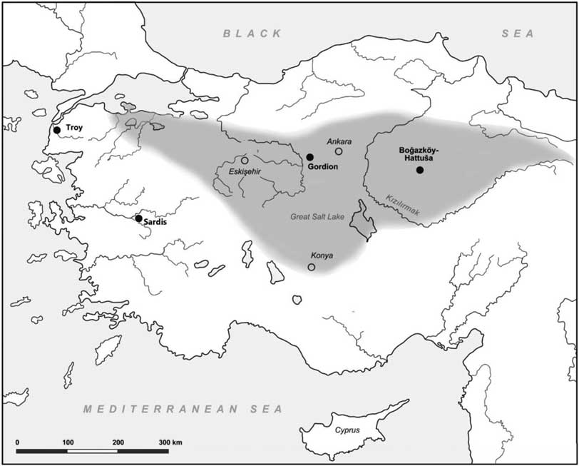
At Gordion a combined program of radiocarbon (14C) and tree ring dating over the last 20 years has radically altered our understanding of Iron Age societal dynamics in central Anatolia (DeVries et al. Reference DeVries, Kuniholm, Sams and Voigt2003; Voigt Reference Voigt2009; Manning et al. Reference Manning, Kromer, Bronk Ramsey, Pearson, Talamo, Trano and Watkins2010; DeVries Reference DeVries2011; Rose and Darbyshire Reference Rose and Darbyshire2011). However, a key period, from LBA collapse to the emergence of the Early Iron Age (EIA) polity of Phrygia, remained poorly understood. Here, we present a new series of 14C dates from LBA and EIA Gordion and the first chronometric framework for the timing, rate and duration of societal reformation at what became the center of the Phrygian state in central Anatolia in the 1st millennium BCE (Figure 1).
Map of Gordion’s location in Turkey, including key sites mentioned in the text and the proposed area of the Phrygian polity (boundaries based on Rose Reference Rose2017).

Background
The widespread political collapse across the eastern Mediterranean, marking the end of the LBA, is often cited as a prime example of societal disruption (Knapp and Manning Reference Knapp and Manning2016). More recently, the nature of this “event” has been queried as mounting evidence suggests a more complex and variable scenario played out across the region (Knapp and Manning Reference Knapp and Manning2016). In Anatolia, key sites for this LBA collapse (Hattuša and Troy) highlight substantial differences both in the nature of the evidence and the cultural processes at work over the 13th–12th c. BCE (Figure 1; Seeher Reference Seeher2010; Aslan et al. Reference Aslan, Kealhofer and Grave2014).
At Gordion, situated between these two LBA centers, local ceramic traditions and administrative technologies place it within the North Central Anatolian material cultural sphere and Hittite influence (Glatz Reference Glatz2009, Reference Glatz2011). Following the well-documented sudden demise of Hittite hegemony, substantial archaeological evidence reveals dramatic cultural transformation at Gordion (Sams Reference Sams1995, Reference Sams2012; Henrickson and Voigt Reference Henrickson and Voigt1998; Voigt and Henrickson Reference Voigt and Henrickson2000; Voigt Reference Voigt2002, Reference Voigt2009, Reference Voigt2011, Reference Voigt2013). By the 8th c. BCE the town had transformed into the political center of Phrygia (Rose Reference Rose2011; Figure 1), a polity that subsequently gained control over much of central and western Anatolia.
Our understanding of the tempo of political transformation from the LBA to the emergence of the Phrygian polity has been based on limited and relatively indirect evidence (e.g., the speed of depositional processes in this period from the stratigraphic sequence of a deep sounding excavated in 1988–1989 and historically framed, relative ceramic and stylistic parallels [Voigt Reference Voigt1994]). Only with a more precise chronology can we evaluate the rate and nature of political transformation from the LBA to the emergence of the Phrygian polity.
A History of Dating at Gordion
Beginning in the late 1950s, University of Pennsylvania researchers Elizabeth Ralph and Henry Michael played key roles in refining 14C applications, including the development of correction offsets through tree ring calibration and the recognition of the importance of short-lived botanical samples for dating (e.g., cereal grains). Samples from excavations at Gordion, sponsored by the University of Pennsylvania, were used for some of the first 14C determinations from the newly established University of Pennsylvania Radiocarbon Laboratory, with results published in the first issue of Radiocarbon (Ralph Reference Ralph1959). These results included dates for one of the most intact Phrygian levels at the site, subsequently known as the Destruction Level, a catastrophic conflagration that served to preserve a large number of contemporary features, including the walls and contents of multiple large, formal structures (e.g., Young Reference Young1958). Young’s date for the Destruction Level (which he attributed to a barbarian raid ca. 700 BCE), coupled with the subsequent identification of an extended 400-yr-long 14C calibration plateau (800–400 BCE), ensured that the original 14C results were ignored for decades in discussions of the Gordion absolute chronology (Manning and Kromer Reference Manning and Kromer2011).
But although Young had used documentary sources for his Destruction Level date, he also saw that the preservation of large unburnt timbers in Phrygian tumuli and burnt roof beams in the Iron Age settlement provided an extensive and reliable sample for dendrochronological sequencing. After an initial study by Bryant Bannister, Young encouraged then graduate student Peter Kuniholm to develop a high resolution dendrochronological alternative for dating the site using the substantial timber archive at Gordion (Kuniholm et al. Reference Kuniholm, Newton and Liebhart2011:80–81).
In the 1970s, Kuniholm studied tree rings from the MM Tumulus at Gordion for his PhD research at the University of Pennsylvania (Figure 2). In 1976, he established the Aegean Dendrochronology Project at Cornell University, initiating a region-wide dendrochronological program. The result was a “floating” 1028 year dendrochronology with a resolution of +4/–7 years for Gordion, and a 2000 year sequence for the Anatolian region, that extended from the Middle Bronze Age through to the Iron Age (Kuniholm et al. Reference Kuniholm, Newton, Griggs and Sullivan2005, Reference Kuniholm, Newton and Liebhart2011; Manning and Kromer Reference Manning and Kromer2011). This sequence was then tied to an absolute 14C framework using successive 10-yr ring segments of logs from Tumulus MM. The combination of dendrochronological and 14C sequences enabled the construction of the MM tomb chamber to be precisely dated (740 BCE; Manning et al. Reference Manning, Kromer, Kuniholm and Newton2001, Reference Manning, Kromer, Bronk Ramsey, Pearson, Talamo, Trano and Watkins2010). Dendrochronological sequencing of timber beams burned in the Early Phrygian Destruction on the Citadel Mound proved more controversial, with ancient timber beam recycling coming to the fore as an argument against accepting the tree-ring dates prima facie.
Gordion region aerial view with Citadel Mound, and tumuli (including MM) in upper right quadrant.

In the mid-1980s, DeVries returned to the outstanding chronological issues at Gordion to identify problems that could be resolved with a fine-grained relative and absolute chronology for the site. In 1988–1989, a renewed effort to obtain fresh data resulted in the excavation of two soundings that extended from the modern surface of the mound into LBA strata (Voigt Reference Voigt1994). Subsequently, a new program of high resolution 14C determinations established the late 9th c. BCE date for the Destruction Level. It also involved review and calibration of the original University of Pennsylvania dates. Of the 27 results reported in 1959, two 14C determinations in particular stand out, from short-lived samples (seed and reeds) from the Destruction Level of Megaron 3. When calibrated, these determinations were shown to correctly bracket a broad but accurate 10th/9th BCE age range (1σ calibrated min-max 976–792 BCE).
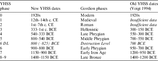
The new excavations allowed Voigt to define the Yassihöyük Stratigraphic Sequence (YHSS) made up of 10 chronological units (Table 1; Voigt Reference Voigt1994). Phases within the sequence were correlated with significant breaks in material culture and/or depositional processes. As analysis and excavation continued, chronologically or functionally significant “sub-phases” were also identified within each phase. Where possible, the phases correspond in name and relative date to chronological units previously designated for Gordion (DeVries Reference DeVries1990); however, the YHSS phases are always tied to specific stratigraphic complexes, in contrast to the more generalized architectural phases developed by Young and DeVries.
YHSS sequence showing relative dates, dates accepted in the 1990s, and revised absolute dates for the YHSS sequence based on subsequent redating (including new dates published here). In this table, we rounded the revised modeled dates (see Table 4).

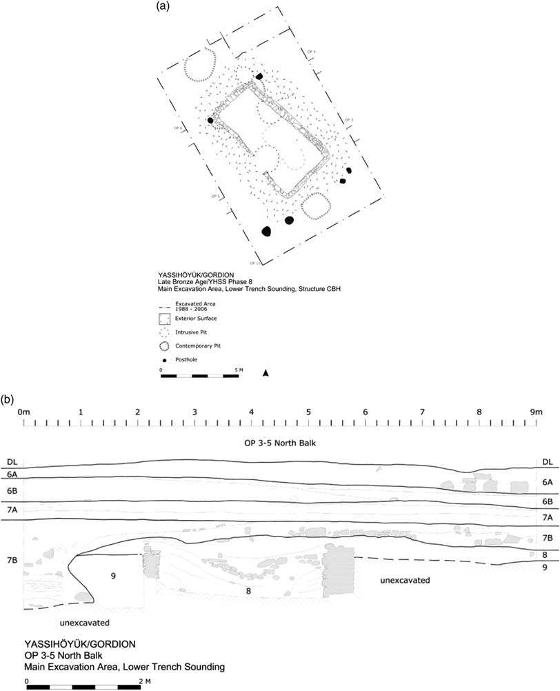
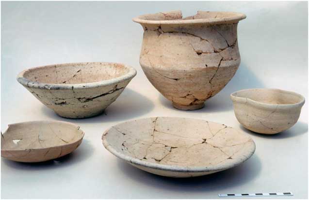
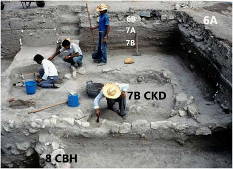
Within the 1988–1989 Lower Trench Sounding (LTS), the latter part of the Late Bronze Age/YHSS 8 was represented by a large semi-subterranean domestic structure and associated surfaces cut by cylindrical pits with a layer of phytoliths at the bottom, indicating cereal storage before they were eventually filled with trash (Figures 3a and b). All phase 8 contexts produced pottery closely related to LBA Boğazköy types (Figure 4). Stratified above phase 8 deposits were surfaces cut by smaller semi-subterranean structures assigned to YHSS 7B, the beginning of the Early Iron Age. As archaeological features, erosion surfaces represent weathering, and indicate some length of time between abandonment and reoccupation; the absence of erosion surfaces between the 8 and 7B deposits strongly suggested that the break in material culture in 7B represented events following immediately or very soon after the abandonment and filling of the YHSS 8 house (Figure 5).
(a) Plan of YHSS 8 [LBA] building; (b) Stratigraphic section (southern balk of Operations 5 and 3 running east–west) in the Lower Trench Sounding, with YHSS8 [terminal LBA] to 6A [Destruction Level]. The section shows the relationship of the YHSS 8/LBA structure and the YHSS 7B/EIA structure immediately above it.

Typical Late Bronze Age ceramic forms from collapse within the CBH structure [YHSS8].

Excavating YHSS 7B CKD structure in the LTS. The sequence shown in Figure 3b is labeled in the photograph. The YHSS 8/ LBA CBH structure immediately underlies the YHSS 7B/EIA CKD structure. Line of white stone chips in the balks marks the beginning of YHSS 6B and the construction of Early Phrygian monumental architecture.

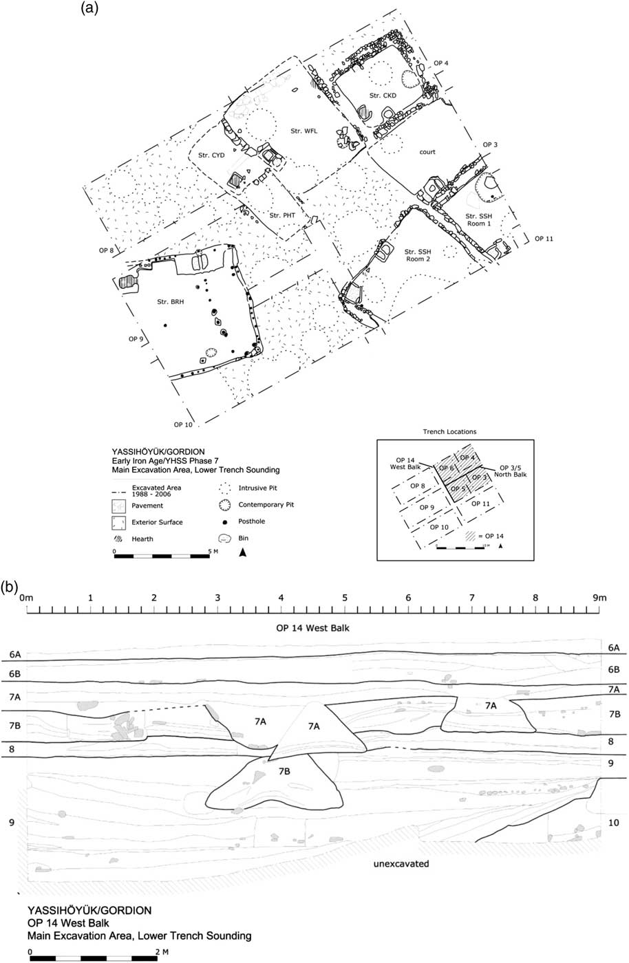
During 7B, construction of new houses followed a pattern of “spiral stratigraphy” where abandoned houses are left to collapse with new ones built on adjacent level surfaces (Figure 6a, CYD, WFL and CKD structures). Later in 7B, large bell-shaped storage pits were cut and filled with trash (Figure 6b). In both the houses and the pits, individual sherds of LBA date were recovered but none joined. These LBA sherds are best interpreted as secondary and tertiary deposits, derived from 7B house walls that were built with mud from phase 8 deposits that had been dug out to create the house pits. Typical 7B pottery could often be restored as complete pots.
(a) This plan reveals the spiral stratigraphy discussed in the text for YHSS7. 7B units are to the north with houses, surfaces, and pits; to the south of an open area are two YHSS 7A houses; (b) Stratigraphic section (Operation 14 balk running north-south) showing intercutting pits dating to YHSS 7. The bell-shaped pits are clearly evident in this section.

The later EIA sub-phase, YHSS 7A, was initially defined by a house that burned, preserving its contents. Although the “Burned Reed House” was semi-subterranean and continued the spiral stratigraphy created by 7B houses, both construction features and ceramics are very different from 7B (Figures 5 and 6a [BRH and SSH structures]). Stratigraphically later 7A contexts produced restorable pots typical of both 7B and 7A. During the latest part of YHSS 7A, the area within the LTS was open with clean surfaces cut by bell-shaped pits (Figure 6b). Pottery in these pits was typical of 7A, and represents a transition to YHSS 6B (earliest Early Phrygian) when the excavated area was an open court periodically renovated with clean clay fills. Surrounding the 6B court were stone structures that were recovered both in the LTS and in Young’s soundings. Young also exposed the initial Early Phrygian (EP) fortification system (Voigt Reference Voigt2013). No timbers suitable for dendrochronology were found in the deposits below those of the Early Phrygian/YHSS 6A period.
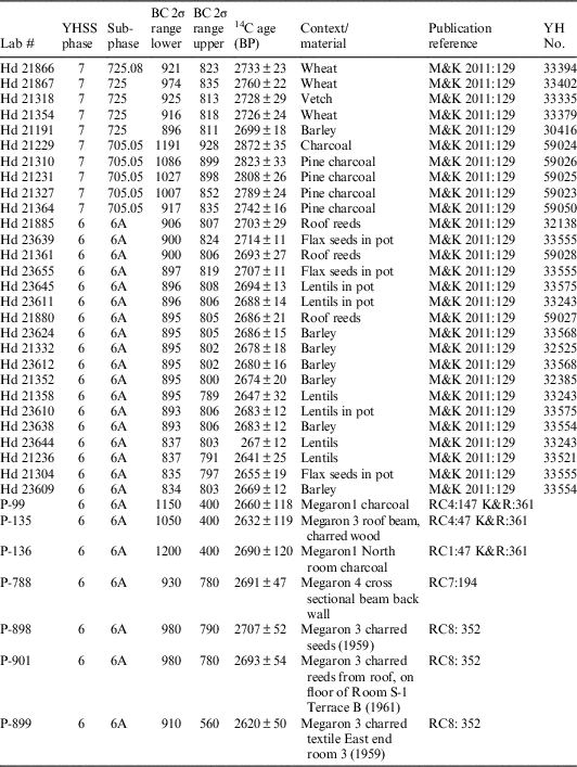
The 1988–1989 sounding produced a secure stratigraphic sequence and relative chronology for the site, but little information on the date or duration of the EIA, or the earliest EP phase (i.e. YHSS 7 and 6B). For subsequent periods, however, the results of new excavation were surprising: stratigraphic evidence and imported pottery recovered from secure contexts undermined the historically derived dates favored by Young for the EP Destruction and for the subsequent Middle Phrygian YHSS 5 rebuilding of the elite quarter (Voigt Reference Voigt2005, Reference Voigt2007, Reference Voigt2009). In 2000, taking up the question of the Destruction Level date as presented to them by DeVries, Sams, and Voigt, Kuniholm and the dendrochronology laboratory at Cornell University worked with Bernd Kromer at Heidelberg University to date short-lived seed samples from one room within the YHSS 6A Destruction Level (TB2A). Results provided a late 9th c. BCE date range (ca. 820–800 BCE) for the fire, supported by dendrochronology of newly excavated timbers as well as by a reanalysis of the pottery and other finds from the Destruction Level (Rose and Darbyshire Reference Rose and Darbyshire2011; DeVries et al. Reference DeVries, Kuniholm, Sams and Voigt2003). This provided the first chronometric evidence to counter the proposed 700 BCE destruction linked to a Kimmerian invasion. At the same time seed samples from the 7A Burnt Reed House were submitted for AMS 14C dating by the Kuniholm-Kromer team (Table 2). These proved to be unexpectedly late, dating the Early Iron Age/7A to the early 10th century (Henrickson and Voigt Reference Henrickson and Voigt1998). The new data contradicted a date based on stylistic comparisons that had placed the beginning of the Early Phrygian period (6B) well before the 10th c. BCE (Sams Reference Sams1989; Manning and Kromer Reference Manning and Kromer2011; Figure 6a).
Previously published 14C dates for YHSS 7-6 (see Manning and Kromer Reference Manning and Kromer2011 [M&K 2011 in table] for detailed information and references). Includes dates from materials excavated in YHSS6 levels in Rodney Young’s excavation of the 1950s and early 1960s in the Citadel Mound (aka City Mound), dates published by DeVries et al. (Reference DeVries, Kuniholm, Sams and Voigt2003) and Manning and Kromer (Reference Manning and Kromer2011).

In 2016, work on two monographs dealing with the pre- and proto-history of the site raised several outstanding questions about the complex dynamics of the Late Bronze Age and Early Iron Age in the Gordion region. First, while there was clear evidence for significant cultural transformations at the end of the Bronze Age at Gordion, the lack of LBA dates limited our ability to correlate these transformations with the abandonment of Hattuša and/or Hittite political collapse. Potentially, Hittite influence at Gordion could have ended prior to political collapse in the core, or it could have extended past the abandonment of the capital, as it seems to have elsewhere (D’Alfonso Reference D’Alfonso2014). If the transformations at Gordion did not correspond in time with those at Hattuša, then the “collapse” of the Hittite Empire would appear to have involved more complex regional dynamics than previously assumed. A second question centered on the timing of the emergence of Phrygian political power. While a relatively large number of samples were used to construct a high resolution chronological framework for the end of the EP (YHSS 6A), our understanding of the rate and timing of the preceding emergence of Phrygian power remained reliant on a handful of dates and stylistic comparisons (e.g., Sams Reference Sams1995). To answer these questions required better definition of the chronological bracketing for the Early Iron Age at Gordion and a new set of 14C dates.
SAMPLE AND METHODS
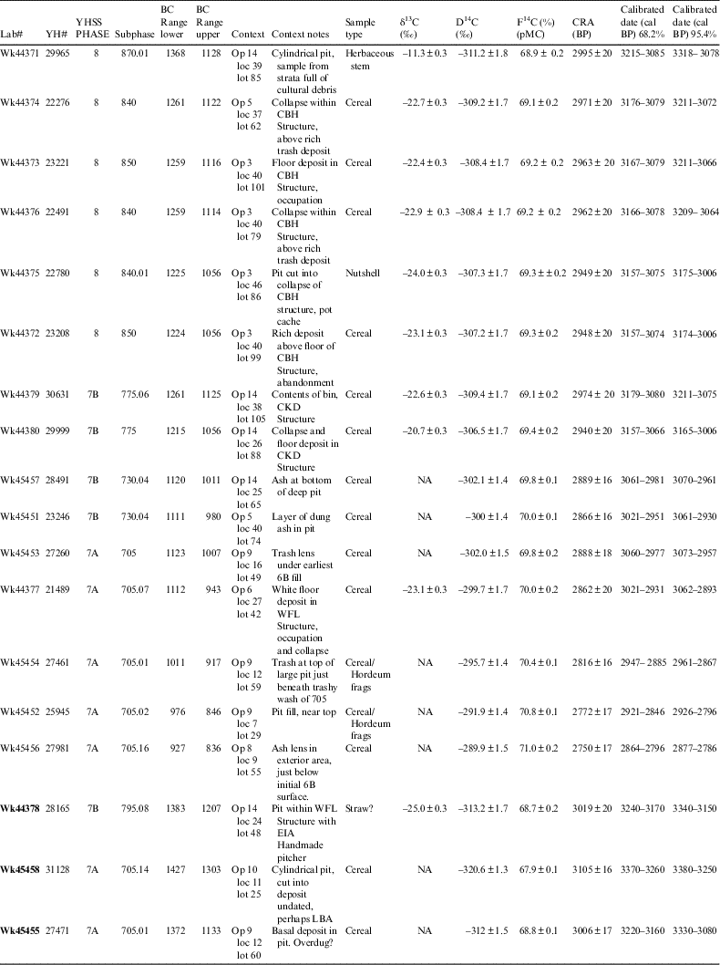
Samples of short-lived plant remains were collected for 14C dating in 1988–1989 and stored at the University of Pennsylvania Museum (mainly cereal grains). From these, we selected 18 samples of indeterminate cereal or barley and other short-lived remains (identified by Naomi Miller) from LBA to EP contexts at Gordion (Table 3). Sample selection was constrained by size and by our interest in phase transitions. Large and stratigraphically secure samples from the latest LBA contexts (the YHSS 8 house, its collapse and associated pits) were relatively abundant and three roughly similar botanical samples from relatively contemporary contexts were selected (Wk44371, Wk44372, Wk44373). Three more samples come from collapse within the abandoned YHSS 8 house (W44374, 44375, 44376). EIA samples, smaller and fewer in number, were assumed to represent a longer period of time based on the depth of YHSS 7 deposits. The selected samples were therefore drawn from strata representing the beginning, middle, and end of the EIA. Samples from 7B come from collapse above a house floor, fill in a bin in the same house and the rest from pits (Wk44378, Wk44379, Wk44380). We also focused on the beginning and end of YHSS 7A. Two samples came from a single late 7B pit (Wk45451, Wk45457), while six came from the latest 7A deposits, including pits and trash levels in the open court immediately below YHSS 6B construction levels (Wk44377, Wk45452, Wk45453, Wk45455, Wk45456, Wk45458).
Sample information for the 18 samples dated and reported here with YHSS context information. Note the bottom three samples (in bold) are too old and are interpreted as materials from over excavating pit margins (i.e. excavator dug into earlier deposits—the matrix cut by the pit) as discussed in the text.

While based on short-lived plant remains, 14C determinations for the EIA suggest a more extended range than thought likely by the excavators. The potential for mixed deposits affecting sample integrity at Gordion is greatly increased by the complexity of large-scale earth moving projects for pithouse construction and the excavation of large storage pits in both the LBA and EIA (Figure 6b). For dating secure contexts, reliance on samples from pits introduces potential sources of mixing including possible redeposition of material from the pit matrix or eroding pit sides: in some cases, excavators unintentionally dig beyond the often fragile pit margins, introducing older materials. Nevertheless, for the EIA, pit contexts were among the best available for providing short-lived samples for 14C analysis.
RESULTS
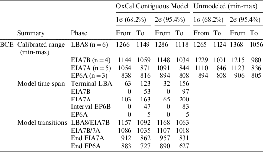
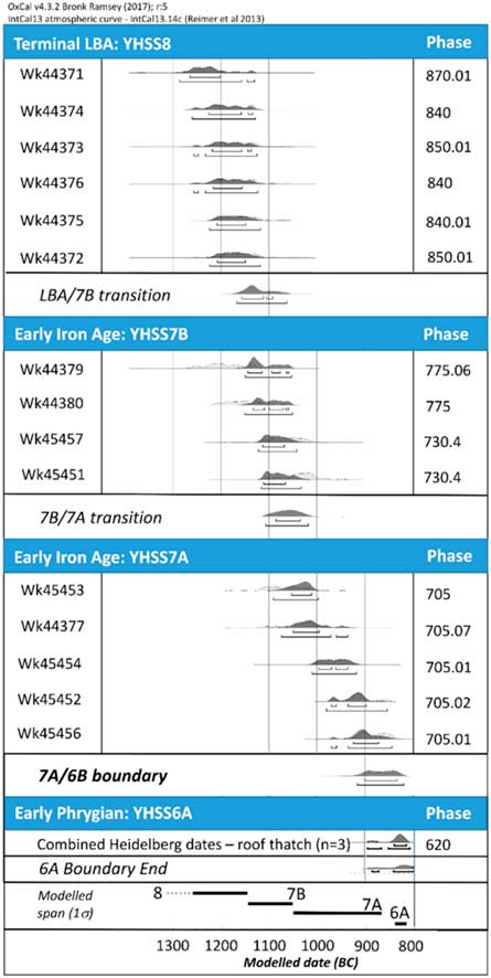
The 14C dates were modelled with OxCal 4.3.2 (Bronk Ramsey Reference Bronk Ramsey2009, Reference Bronk Ramsey2017) using excavated stratigraphic relationships as priors (LBA Level 8 CBH building < Level 7B CKD building < Level 7A [interval with no dates 6B] < Level 6A) (Tables 3 and 4; Figure 7). Of the two modeling options most relevant for this stratigraphic scenario (i.e. sequential or contiguous), the contiguous model provided the best fit for the 14C data. One sigma (68%) ranges of the modeled data emphasize the continuous nature of the overall sequence (Table 4; Figure 7).
Summary of modeled and unmodeled calibrated ranges for the OxCal Contiguous model of 15 AMS results discussed in the text using the minimum and maximum 1 and 2σ values for samples in each YHSS phase. The modeled dates are organized by Calibrated Range, Time Span, and Model Transitions (the range of the contiguous phase boundaries). EP/6A is modeled based on the three Heidelberg dates noted in Figure 7. EP/6B is included as a modeled interval.

OxCal contiguous model for AMS 14C determinations of short lived samples (cereal grains, nutshell, twig) from terminal Late Bronze Age (LBA) YHSS 8, Early Iron Age (EIA) YHSS 7B and 7A, and Early Phrygian YHSS 6A excavated phases. The model uses stratigraphic relationships as priors (LBA Level 8 CBH building > Level 7B CKD building > Level 7A > Level 6A thatching). Heidelberg AMS 14C determinations for 3 samples of roof thatch/reeds (phragmites?). Hd21885 (2703 ± 29); Hd 21361 (2692 ± 26); Hd 21880 (2686 ± 21) (Manning and Kromer Reference Manning and Kromer2011:133) were combined to represent a summary probability estimate of the final late 9th century conflagration, which ends the Early Phrygian period (YHSS6). Since no 14C determinations were available for 6B, this is modeled as an interval between 7A and 6A (see Table 4). Dark grey regions of probability curves = modelled best fit; light grey regions = premodeled distribution. Phase spans at the bottom of the figure are based on modeled 1σ distributions.

These 15 AMS results for short-lived plant remains are supplemented by results from 29 long and short-lived samples (charcoal and seeds) collected from YHSS 7 and 6A deposits, submitted for 14C dating by Peter Kuniholm as part of the larger study of Gordion chronology (Table 2). We include these data, as well as the 1960s 14C dates, to provide an integrated view of the 13th–9th c. BCE chronology at Gordion. (Currently, there are no samples available for dating YHSS 6B.)
The duration of each phase was also calculated. The modeled 1σ dates from YHSS 8 (LBA) capture the period 1266–1149 BCE, while the range for YHSS 7 (EIA) context 1σ dates is 1144–871 BCE. The EIA therefore appears lasts between ca. 150 and 200 years and extends into the 9th c. BCE (Table 4; Figure 7). While previous dates suggested this, the additional modeled results from the LBA through EIA confirm it.
The EIA is stratigraphically divided into two phases, with the earlier EIA 7B (~50–100 yr) representing a substantially shorter time span than 7A (~160–200 yr). Dates from YHSS 7A contexts span 1054–871 BCE (1σ range). This contradicts the shorter time span suggested by the amount of deposition for this phase and may reflect the reliance on pit contexts and collection of samples from redeposited material, a problem noted above.
To provide a terminus for YHSS6 (the Early Phrygian period), we combined three previously published dates for the YHSS6A Destruction Level (Manning and Kromer Reference Manning and Kromer2011). Modeling of these dates allowed us to constrain the Early Phrygian period to a very short 50–100-yr span before the late 9th c. BCE conflagration (from 912/862 to 838/816 BCE [1σ range]).
Our new data extend the high resolution Destruction Level chronology by providing age estimates for the earlier LBA to EIA archaeological sequence, representing a larger number of archaeological contexts than previously published.
DISCUSSION
The new dates for Gordion provide our first detailed insight into the timing and nature of Late Bronze Age Hittite collapse in this region of central Anatolia, as well as the subsequent timing of the emergence of the Early Phrygian polity at Gordion.
Terminal Late Bronze Age (YHSS 8)
At multiple sites across the larger region, the end of the LBA is marked by a destruction horizon (Knapp and Manning Reference Knapp and Manning2016). This horizon has been used to support a view that LBA polities were catastrophically terminated by a large-scale and integrated phenomenon (e.g., the Sea Peoples, or drought, or economic transformation (e.g., Sherratt Reference Sherratt1998; Oren Reference Oren2000; Fairbairn and Omura Reference Fairbairn and Omura2005). However, recent work at several key sites suggests the end of Hittite hegemony was more complex than a “single event horizon” (Knapp and Manning Reference Knapp and Manning2016). If not a chronologically synchronous, region-wide phenomenon, understanding the processes of transformation at the end of the LBA therefore requires establishing the timing and duration of change on a site by site basis.
Elite abandonment of the Hittite capital of Hattuša (modern Boğazköy) appears to have occurred in the late 13th c. BCE (Seeher Reference Seeher2001, Reference Seeher2002; Schoop and Seeher Reference Schoop and Seeher2006; Beal Reference Beal2011). Boğazköy remained occupied into the Middle Iron Age, but on a small domestic scale (Genz Reference Genz2006). The administrative function of the Hittite capital moved south for a short period, but Hittite power appears to have lasted only another few decades at most (ca. 1180 BCE; Beal Reference Beal2011). Elites in Syro-Anatolian city-centers of NW Syria and SE Turkey adopted aspects of the Hittite power structure in the emergence of Neohittite centers in this region (Peltenburg et al. Reference Peltenburg, Wilkinson and Wilkinson2016).
To the west at Troy, the LBA fortified town was attacked and destroyed in the early 12th c. BCE. Some suggest re-occupation of the town was by immigrants (Aslan and Rose Reference Aslan and Rose2013). However, the EIA people who reoccupied the site immediately or soon after its destruction appear to combine local and immigrant groups (Grave et al. Reference Grave, Kealhofer, Hnila, Marsh, Aslan, Thumm-Dograyan and Rigter2013; Aslan et al. Reference Aslan, Kealhofer and Grave2014), highlighting a more complex and dynamic process of EIA population “churning” than previously assumed.
Taken together, the elite abandonment of Hattuša in the late 13th c./early 12th c. BCE, along with the destruction and reoccupation of Troy, suggests a multi-generational phase of increased interaction and political and economic disruption across much of Anatolia.
The modeled dates for the end of the LBA/beginning of the EIA at Gordion suggest that Hittite influence ended near the middle of the 12th c. BCE, soon after Hittite elite withdrawal from Hattuša, followed by a rapid and continuous LBA/EIA transition. There are no stratigraphic discontinuities between the LBA and EIA houses: the EIA CKD structure sits directly on top of the late LBA CBH house, and the modeled dates reveal how little time passed between the collapse of the CBH house and the construction of the EIA house (Figure 7).
Arguably, the engagement of Hittite elites in conflicts with both the Kaška and groups to the south in response to changing political and economic conditions likely affected most of western Anatolia in the late 13th c. BCE. The dates for the LBA/EIA transition at Gordion suggest the shift in organizational scale and domestic practices was swift (within a single generation). This shift also appears to follow rather than precede the collapse of Hittite power. By the end of the 12th c. BCE, the EIA occupation at Gordion included groups practicing a household-scale economy (Henrickson and Voigt Reference Henrickson and Voigt1998). Although there is a strong break in material culture between the excavated samples for YHSS 8 and 7B, there is no evidence for violent upheaval and it seems likely that the initial EIA community (and perhaps the regional population) represented a new complex mix of local and immigrant groups as at Troy (Aslan et al. Reference Aslan, Kealhofer and Grave2014).
Early Iron Age-Early Phrygian (YHSS 7-6)
The new dates confirm a late termination for the last phase of the Early Iron Age (7A) (Figure 7). The continuous distribution of dates from the EIA to the EP supports an unbroken pattern of occupation between the last EIA phase (7A) and the Early Phrygian period (6B–6A). Based on the current extent of EIA excavations, there is little evidence of change in material cultural complexity during the EIA period (7A), beyond the re-emergence of wheel-thrown buff ware pottery and the unique form of the Burnt Reed House. Even though there are no dates from YHSS 6B, the modelled dates for 7A and 6A provide a maximum window of 50–80 years (1–2σ) for 6B, the period when large stone buildings and a fortification system first appear in IA Gordion. One of the most significant implications of this very late end to the EIA (1σ: 871 BCE), is that it curtails the EP period (1σ: 862–816 BCE; DeVries et al. Reference DeVries, Kuniholm, Sams and Voigt2003; Manning and Kromer Reference Manning and Kromer2011).
The radical transformation from the last phase of the EIA, with small scale household contexts, to the full blown development of the Citadel by YHSS6A appears to have occurred within two generations (modeled ~55 yr). It is of course possible that late EIA occupation elsewhere on the mound, or at another settlement in the immediate area, included a more complex material record; however, currently we lack this evidence. In a very short time, Early Phrygian Gordion (YHSS6) witnessed substantial and extensive construction activity (i.e. at least two phases of construction of a city wall, two re-organizations of the elite zone with at least twelve megarons within the wall, the construction of a massive Terrace production complex, as well as the construction of at least six elite [royal?] tumuli which begins ca. 850 BCE based on stylistic parallels; Rose and Darbyshire Reference Rose and Darbyshire2011: fig 7.9).
Managing the multiple, ongoing large-scale production projects and the construction of truly monumental architecture at and around Gordion, must have involved considerable logistical challenges in terms of labor and supplies over such a short period. That these challenges were successfully met suggests the creation and implementation of highly effective ideological strategies by Early Phrygian ruling elites that nonetheless remain poorly understood.
CONCLUSIONS
The LBA and EIA dates presented here provide the most comprehensive set of EIA dates for central Anatolia beyond Boğazköy, and enable our first detailed evaluation of the timing and tempo of cultural transformation at a critical juncture for the region. The dates for the beginning of YHSS7/EIA support the premise that Hittite influence across western Anatolia waned by the mid-12th c. BCE. The collapse of Hittite power (1180 BCE) seems to have only impacted regional centers over the course of the next generation (i.e. by mid-12th c. at Gordion). The timing and types of material changes at Gordion suggest a radical reorganization of the economy over a relatively short, 50–80-yr span. The distinctive EIA material culture at Gordion suggests an increase in population mobility across the region.
The current material record of the EIA at Gordion reflects a relatively small scale conservative community from the 12th through to at least the early 9th c. BCE. The emergence of Gordion as a Phrygian capital in the middle of the 9th c. BCE is all the more striking for its speed and scale. The pattern of assimilation seen at Gordion suggests that elite consolidation of power involved the creation of effective strategies that must have capitalized on emulation, memory, a charismatic leader, innovation, or likely all of these (Earle Reference Earle1987; Van Dyke and Alcock Reference Van Dyke and Alcock2003; Harmanşah Reference Harmanşah2013). Within as little as two generations, leaders established control over enough resources to enable multiple concurrent large-scale building projects, including monumental burial mounds.
Archaeologists have long discussed issues associated with “secondary state formation” (Price Reference Price1978; Joffe Reference Joffe2002), for which the emergence of the Phrygian state is arguably a prime example. Secondary states are those which develop, in generally the same region, after the collapse of the first states (e.g., the sequence of states in Mesopotamia after the Early Dynastic period). Parkinson and Galaty (Reference Parkinson and Galaty2007) suggest two factors strongly shape secondary state formation: the degree and type of interaction with neighboring groups and prior social structures. Models of state formation emphasize, sometimes along a continuum, emergent power based on corporate strategies vs. individualizing network strategies (Blanton et al. Reference Blanton, Feinman, Kowalewski and Peregrine1996). While detailed discussion of the evidence for assessing these strategies at Gordion is beyond the scope of the current paper, individualizing network strategies and larger scale regional interaction clearly played critical roles in the unusually precocious development of the Phrygian state outlined here (Sams Reference Sams1974, Reference Sams1988, Reference Sams1989, Reference Sams1995).
ACKNOWLEDGMENTS
We would like to thank Peter Kuniholm for comments on an early draft of this paper, as well as the constructive suggestions of two anonymous reviewers. Naomi Miller collected and identified the botanical material used in this study. This work was funded by the Australian Research Council (DP190102089) and the National Science Foundation (0513403). The 1988–1989 excavations at Gordion were funded by the U.S. National Endowment for the Humanities (NEH), the National Geographic Society, and generous private donors. All modern archaeological research at Gordion has been sponsored and supported by the University of Pennsylvania Museum. We would also like to acknowledge the support of Gordion site directors C.B. Rose and the late G.K. Sams.