





Introduction
Israel’s national Emergency Medical Services (EMS) system has accumulated substantial experience in terrorism, missile attacks, and mass-casualty incidents. Previous Israeli EMS reports have described large-scale civilian response under fire, secondary transfers, volunteer responder integration, and national alertness as operational features of the system. Reference Jaffe, Wacht and Davidovitch1–Reference Adini and Peleg5
Traditional mass-casualty incident doctrine often assumes an identifiable scene, a perimeter, a casualty collection process, and a command structure that expands around the incident site. This model remains useful for many bombings, shootings, crashes, and conventional impact events, but it becomes less accurate when the medical footprint is distributed across several separated sites at the same time. Reference Raiter, Farfel and Lehavi6–Reference Rush, Lauria and DeSoucy9
Cluster munitions create distinctive civilian health hazards because submunitions can disperse over a wider area, may injure civilians at multiple points, and may leave unexploded hazards after the initial impact. For EMS command, the defining problem is therefore not only the number of casualties, but also the spatial uncertainty and simultaneity of the response footprint. Reference Fares and Fares10–12
As used in this Disaster Report, a single-warhead event refers to one missile detonating at a single impact point, producing a compact medical footprint; a cluster-munition pattern event refers to a missile releasing multiple submunitions that detonate at dispersed, discrete impact points across a wider geographic area, producing multiple concurrent impact sites. This operational distinction is based on the dispersed versus compact geometry of the resulting call and casualty pattern, not on independent ordnance identification (see Limitations).
To the authors’ knowledge, this report is among the first to describe EMS dispatch and command adaptation specifically to the dispersed geographic pattern of cluster-munition strikes, though prehospital literature on cluster-munition casualties and civilian health hazards more broadly does exist. Reference Fares and Fares10–12 The objective of this Disaster Report is to describe how compact and dispersed missile impact patterns were recognized and managed by Magen David Adom (MDA; Ramla, Israel), Israel’s national EMS organization, and to highlight the operational role of a distributed EMS model in converting early field reports into usable command information. The purpose of the report is not ordnance classification or military analysis, but description of the EMS command implications of these two patterns (Figure 1).
Schematic Contrast between Single-Warhead and Cluster-Munition Pattern Events. Note: Illustrative schematic, not to scale and not derived from geocoded event data; provided to clarify the operational distinction between compact single-impact events and dispersed, multi-municipality corridor events.

Figure 1. Long description
Panel A: Single-warhead event schematic. A single municipality with a compact impact point. Distress call locations and ambulances converge on one point. Maximum geographic spread is less than 400 meters. Panel B: Cluster-munition pattern event schematic. Multiple municipalities with impact points dispersed along an elongated corridor. Calls and impact points are spread out. Axis orientation, axis length, and primary axis ratio are indicated.
Source
The six events included in this report were selected from the March 2026 missile campaign based on data completeness and confirmed munition type. The events were selected to contrast two operational geometries encountered during the same missile campaign. The first pattern was a compact impact area, in which emergency calls, responders, casualties, and ambulances converged on a limited geographic area. The second pattern was a dispersed cluster-munition pattern, in which calls and responder reports emerged from multiple municipalities along an elongated corridor.
As used in this Disaster Report, a corridor is an operational-dispatch construct: the elongated geographic envelope spanning the observed call locations of a cluster-munition pattern event, encompassing multiple discrete impact points. It is a descriptive characterization of the actual call and casualty distribution, not a formal ballistic, engineering, or blast-effect pathway.
Information for this report was derived from MDA national dispatch and operational response records, including call timestamps, municipal location, dispatch category, ambulance dispatch data, first ambulance arrival time, number of treating crews, number of casualties treated or evacuated, and highest recorded injury severity.
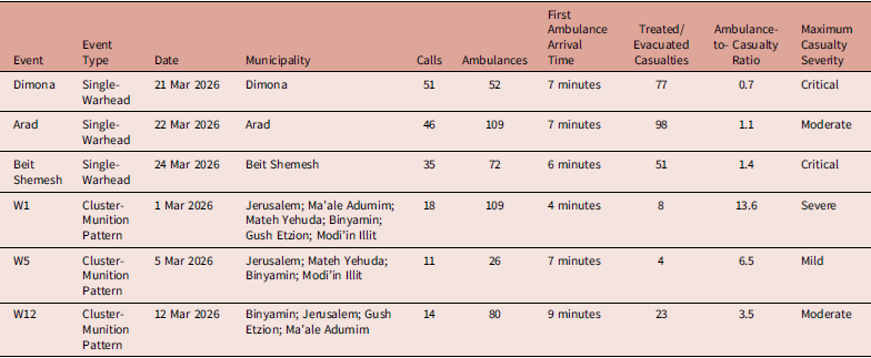
While missiles are in flight, the Home Front Command (HFC, the Israeli Ministry of Defense body responsible for civil defense and public warning) broadcasts real-time threat alerts through multiple public channels: the official HFC app, direct cell broadcasts to all phones in the threatened area, and live overlays on all television channels. 13,Reference Tovy14 Command and dispatch personnel from MDA used this publicly available information as an early threat layer during the dispatch phase. Operational debriefings and field reports were used to classify events as compact single-warhead or dispersed cluster-munition pattern events (Table 1).
Basic Event Characteristics and Operational EMS Data

Table 1. Long description
The table presents data on event characteristics and operational EMS data for various locations and dates. It includes seven rows and nine columns. The columns are labeled Event, Event Type, Date, Municipality, Calls, Ambulances, First Ambulance Arrival Time, Treated/Evacuated Casualties, Ambulance-to-Casualty Ratio, and Maximum Casualty Severity. The rows detail specific events with their respective data. For example, the first row shows an event in Dimona on 21 Mar 2026 with 51 calls, 52 ambulances, a 7-minute arrival time, 77 treated/evacuated casualties, an ambulance-to-casualty ratio of 0.7, and critical maximum casualty severity.
Note: Municipality listings are event-level operational locations rather than patient-level addresses. Ambulance-to-casualty ratio was calculated as ambulances dispatched divided by casualties treated or evacuated; ratios reflect operational deployment under uncertainty and should not be interpreted as measures of efficiency. Higher ratios indicate more ambulances dispatched relative to confirmed casualties, consistent with precautionary deployment while the medical footprint was still being established; lower ratios indicate deployment closer to the confirmed casualty count.
Abbreviations: EMS, Emergency Medical Services; MDA, Magen David Adom.
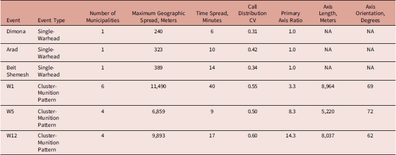
Geographic dispersion metrics reported in Table 2 were derived from event-level call locations mapped using Google Maps (Google Inc.; Mountain View, California USA). Maximum geographic spread was calculated as a spatial radius relative to the incident location, as determined by dispatch and responding teams; for cluster-munition pattern events, for which no single incident location existed, the geometric mean of call locations was used as the reference point instead. Call distribution CV (coefficient of variation) was calculated as the standard deviation of call-location distances from this reference point divided by the mean distance, expressed as a proportion; higher values indicate less uniform spatial clustering. For cluster-munition pattern events, footprint geometry (primary axis ratio, axis length, and axis orientation) was derived directly from the observed, geocoded call locations in the WGS84 geographic coordinate system (EPSG:4326), using a full-featured geographic information system (QGIS, version 3.34 LTR; QGIS Development Team, Open Source Geospatial Foundation; Beaverton, Oregon USA), without predictive, interpolation, or inferential spatial modeling. The major axis was defined as the geodesic line connecting the pair of call locations with the greatest pairwise separation; axis length was the geodesic distance between these two endpoints, and axis orientation was the initial bearing of this line, reported in degrees east of north. The minor axis was defined as the maximum perpendicular distance from any call location to the major-axis line. The primary axis ratio was calculated as the ratio of major-axis length to minor-axis length, with higher values indicating a more elongated distribution. These metrics apply only to dispersed cluster-munition pattern events, for which a single point-source measure would not capture the elongated, corridor-like distribution of calls.
Spatial and Temporal Dispersion of Emergency Calls

Table 2. Long description
A table with 7 rows and 9 columns comparing spatial and temporal dispersion of emergency calls across different events. The columns are Event, Event Type, Number of Municipalities, Maximum Geographic Spread (Meters), Time Spread (Minutes), Call Distribution CV, Primary Axis Ratio, Axis Length (Meters), and Axis Orientation (Degrees). Row 1: Dimona, Single-Warhead, 1, 240, 6, 0.31, 1.0, NA, NA. Row 2: Arad, Single-Warhead, 1, 323, 10, 0.42, 1.0, NA, NA. Row 3: Beit Shemesh, Single-Warhead, 1, 389, 14, 0.34, 1.0, NA, NA. Row 4: W1, Cluster-Munition Pattern, 6, 11,490, 40, 0.55, 3.3, 8,964, 69. Row 5: W5, Cluster-Munition Pattern, 4, 6,859, 9, 0.50, 8.3, 5,220, 72. Row 6: W12, Cluster-Munition Pattern, 4, 9,893, 17, 0.60, 14.3, 8,037, 62.
Note: Geographic metrics are descriptive operational measures based on available call-location data. Axis metrics apply only to dispersed cluster-munition pattern events.
Abbreviation: CV, coefficient of variation.
Ethical approval for this Disaster Report was obtained from the MDA Research Committee; publication was reviewed and approved (meeting date: May 3, 2026). The report is based on retrospective, de-identified, event-level operational EMS data and contains no individually identifiable patient information, images, or direct patient contact. Therefore, informed consent was not applicable.
The analysis is descriptive. Because only six events are included, the tables are intended to show operational separation and pattern recognition rather than hypothesis testing. No clinical outcome analysis, injury-mechanism analysis, or effectiveness comparison is claimed. Exact geocoded point data, call audio, and identifiable patient-level data were not included in the manuscript.
Observations
Magen David Adom did not have to wait for a specific number of emergency calls or a specific number of minutes before suspecting that an event might be dispersed. The HFC broadcasts real-time threat alerts through public channels while missiles are in flight, including the HFC app, cell broadcasts pushed directly to all phones in the threatened area, and live overlays on all television channels. Command and dispatch personnel from MDA received this information at or before the initial EMS dispatch phase, collated through MDA’s proprietary digital dispatch system, developed in-house to integrate the HFC threat layer with incoming emergency calls, field-responder reports, and ambulance status in a single operational view. Subsequent emergency calls and field reports were then used to map the true medical footprint, to identify actual casualty locations, and to prioritize responder allocation.
The most consistent discriminator between compact and dispersed events was geography, not time. In the compact single-warhead events, calls remained within one municipality and maximum geographic spread was less than 400 meters. In the cluster-munition pattern events, calls emerged from four-to-six municipalities and maximum geographic spread reached approximately 6.9km to 11.5km. By contrast, the time interval from first to last emergency call overlapped between groups and was not sufficient by itself to identify the event geometry.
A defining feature of the response was MDA’s distributed operating model. During routine periods, MDA combines national dispatch, ambulance stations, community volunteers, motorcycle first responders, and a large cadre of emergency medical technicians and paramedics who may be off duty but rapidly available. During wartime, this model is reinforced by ambulance dispersion throughout cities and by emergency reserve vehicles that are stored for crisis activation and brought into service rapidly. This structure creates a dense network of potential first medical observers, not only a transport fleet.
In dispersed events, this responder network functioned as a forward sensor layer for command. Motorcycle responders and local volunteers frequently reached or approached affected points before larger ambulances could consolidate at a scene. Reference van der Pols, Mencl and de Vos15,Reference Soares-Oliveira and Moura16 Their early reports clarified whether reported impact points involved actual casualties, access limitations, secondary hazards, or only public alarm. These reports moved information backward to dispatch and command while medical resources were still moving forward toward multiple possible sites.
This bidirectional flow changed the dispatch task. The central question was not merely which ambulance should be sent to the scene, but how to maintain coverage across a corridor, how to avoid over-concentration at the first reported site, how to preserve reserve capacity for later casualty discovery, and how to update hospital notification while the footprint was still developing.
Analysis
The events suggest that dispersed missile attacks require a command concept different from the expanded single-scene mass-casualty incident model. The operational unit is better understood as a corridor containing several possible micro-scenes, some with casualties and some without. The command problem is therefore dynamic allocation across uncertainty rather than simple surge toward the first known impact point.
The practical implication is that early event labeling should combine threat-layer visibility with field verification. Real-time public HFC alerts - broadcast via app, cell broadcast, and television - can identify the possibility of a dispersed pattern before sufficient emergency calls accumulate. Emergency Medical Services calls and first-responder reports then determine whether the threat layer has produced actual medical demand. This distinction is important because alert geography is not the same as casualty geography.
The unique structure of MDA is especially relevant to this problem. A system built only around station-based ambulances may receive many calls from dispersed sites but have fewer medically trained observers already embedded in the affected neighborhoods. In contrast, a dense volunteer and motorcycle responder network can produce rapid clinical and logistical intelligence from several points at once. This advantage is not only faster arrival, it is earlier situational awareness.
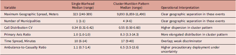
The descriptive data support this interpretation. Cluster-munition pattern events had greater geographic spread, more municipalities, and more elongated call distributions than compact single-warhead events (Table 3). Ambulance-to-casualty ratios were also higher in the cluster-munition pattern events, reflecting an intentionally broad and precautionary deployment under uncertainty rather than inefficiency. However, the sample is small, and these values should not be interpreted as statistically generalizable thresholds.
Descriptive Separation Between Compact and Dispersed Event Patterns

Table 3. Long description
The table compares geographic spread and other variables between single-warhead and cluster-munition pattern events. It has 6 rows and 4 columns. The columns are labeled Variable, Single-Warhead Median (range), Cluster-Munition Pattern Median (range), and Operational Interpretation. The variables listed are Maximum Geographic Spread (Meters), Number of Municipalities, Call Distribution CV, Primary Axis Ratio, Time Spread (Minutes), and Ambulance-to-Casualty Ratio. For Maximum Geographic Spread, single-warhead events have a median of 323 meters (range 240-389) while cluster-munition pattern events have a median of 9,893 meters (range 6,859-11,490). The number of municipalities affected is 1 (range 1-1) for single-warhead events and 4 (range 4-6) for cluster-munition pattern events. The Call Distribution CV is 0.34 (range 0.31-0.42) for single-warhead events and 0.55 (range 0.50-0.60) for cluster-munition pattern events. The Primary Axis Ratio is 1.0 (range 1.0-1.0) for single-warhead events and 8.3 (range 3.3-14.3) for cluster-munition pattern events. Time Spread is 10 minutes (range 6-14) for single-warhead events and 17 minutes (range 9-40) for cluster-munition pattern events. The Ambulance-to-Casualty Ratio is 1.1 (range 0.7-1.4) for single-warhead events and 6.5 (range 3.5-13.6) for cluster-munition pattern events.
Note: Values are descriptive only. No inferential hypothesis testing is presented because there were three events in each group.
Abbreviation: CV, coefficient of variation.
Limitations
Several limitations should be emphasized. First, the report includes a small number of events from one national EMS system. Second, event classification was based on operational information rather than independent ordnance investigation. Third, individual injury patterns, treatments, triage categories, and patient outcomes were not available for inclusion. Fourth, the events occurred in a system with national dispatch, intensive volunteer integration, and wartime reserve capacity; generalizability to EMS systems with different staffing, dispatch, or responder models may be limited.
Conclusions
The transferability of this model to other settings depends on two specific infrastructure elements that are not universal: an integrated public warning system capable of supplying real-time, sub-dispatch threat information to EMS command, and a sufficiently dense network of trained volunteer or off-duty responders distributed across the at-risk area. Emergency systems without a comparably integrated national alert system would need to rely more heavily on accumulating emergency calls to recognize a dispersed event, delaying corridor-level awareness relative to what is described here. Systems without an equivalent volunteer or reserve-responder network would lack the forward sensor layer that allowed MDA to verify actual casualty locations ahead of ambulance consolidation. The underlying command principle, however, is not itself dependent on Israel-specific infrastructure: maintaining corridor-level awareness and avoiding over-concentration at the first confirmed site may be applicable to other disasters with widely dispersed incident locations, such as wildfires or multi-site severe weather events, provided command has access to some form of early, sub-call-volume situational awareness.
Despite these limitations, the report identifies a transferable command principle: when the threat footprint is dispersed, EMS should avoid treating the first confirmed casualty site as the entire incident. Early command should maintain corridor-level awareness, use rapid field observers to confirm actual medical demand, and preserve flexible deployment until the real casualty map is known.
Author Contributions
Oren Wacht: Study conception and design; drafting of the manuscript; critical revision of the manuscript; final approval of the version to be published.
Eli Jaffe: Study conception and design; data acquisition; critical revision of the manuscript; final approval of the version to be published.
Noam Jaffe: Study conception and design; data acquisition; critical revision of the manuscript; final approval of the version to be published.
Funding
No external funding was received for this study.
Competing Interests
The authors declare no conflicts of interest.
Use of AI Technology
Generative AI (Claude, Anthropic; San Francisco, California USA) was used to assist with manuscript revision following peer review, including drafting responses to reviewer comments, language editing, defining technical terminology, and creating the schematic figure. All AI-assisted content was reviewed, verified, and approved by the authors, who take full responsibility for the accuracy and integrity of the manuscript.


 Open access

