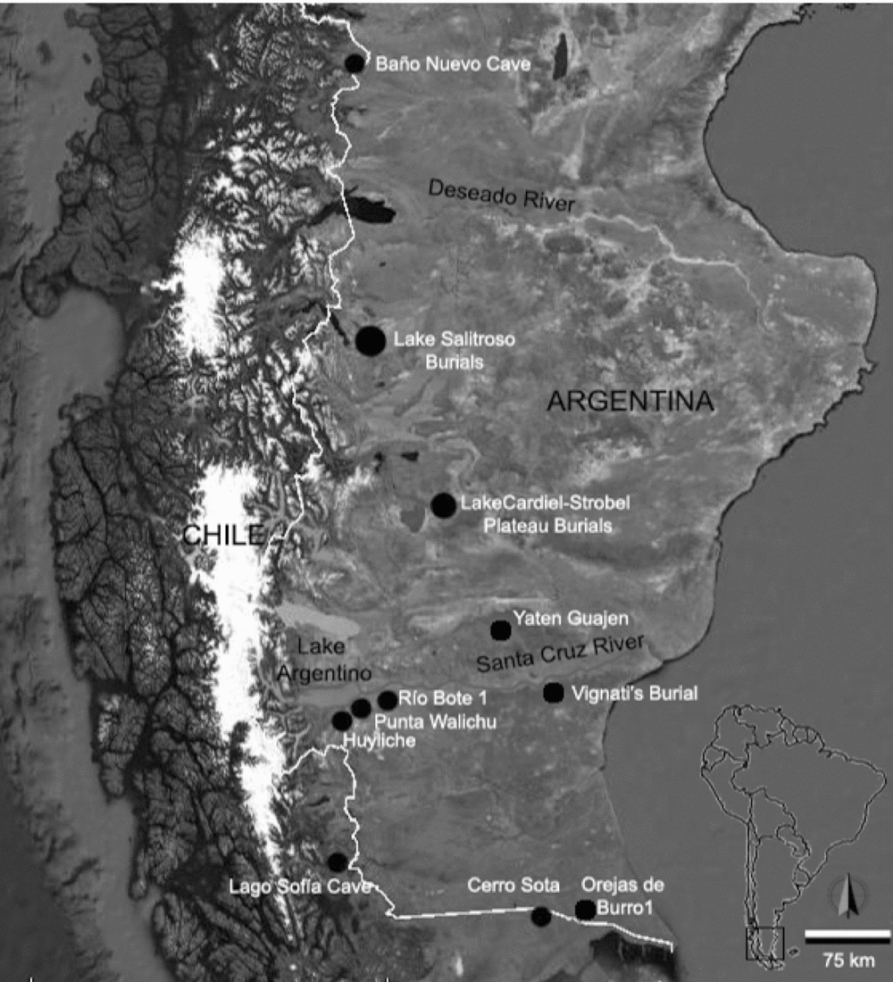
Despite more than 10 years of systematic archaeological research in the upper Santa Cruz River basin (USCRB), its archaeological mortuary record has remained relatively unknown until very recently. Knowledge was limited to two cave burials, the first being an adult burial in the Walichu Cave on the southern shore of Lake Argentino, reported in the late nineteenth century (Moreno Reference Moreno2007 [1877]), and the second, a burial in a volcanic lava tube cave in the middle Santa Cruz basin, north of the river, dated to circa 2500 BP (Franco et al. Reference Franco, Guarido, Guraieb, Martucci, Ocampo, Bárcena and Chiavazza2010). In addition to these, an open-air burial covered by rocks and attributed to the time of Spanish contact was discovered on a hill in the middle Santa Cruz area in 1930, about 10 km from the river (Vignati Reference Vignati1934). This situation contrasts with other areas of continental central and southern Patagonia, where more information on burial practices is available. The earliest human remains found in this broader region were discovered at Baño Nuevo Cave in Chile, 600 km north of the USCRB and dated to circa 9000 BP (Figure 1; Mena and Reyes Reference Mena and Reyes2001). In addition, 160–250 km to the south, burials in excavated pits in rockshelters and caves have provided ages from circa 3900 to 3500 BP (Bird Reference Bird and Hyslop1988; Hedges et al. Reference Hedges, Housley, Bronk and Van Kunkev1992; L'Heureux and Amorosi Reference L'Heureux and Amorosi2010; L'Heureux and Barberena Reference L'Heureux and Barberena2008; Massone Reference Massone1996; Prieto Reference Prieto1991, Reference Franco, Guarido, Montenegro and Ambrústolo1993–94; Prieto and Schidlowsky Reference Prieto and Schidlowsky1992), while about 330 km north of the USCRB, Late Holocene human burials (retrieved from stone structures, locally called chenques, and natural niches) date between circa 2600 and 350 BP (García Guraieb et al. Reference Guraieb, Rafael Goñi and Tessone2015; Goñi et al. Reference Goñi, Barrientos and Cassiodoro2000–2002). In the last few years, our knowledge of human burial practices in the USCRB has increased significantly due to the discovery of two new burial sites: the Río Bote 1 (RB1) rockshelter, and the very Late Holocene chenque at Huyliche 1 (Figure 1; Franco et al. Reference Franco, Guarido, Guraieb, Martucci, Ocampo, Bárcena and Chiavazza2010).
Location of Río Bote 1 and other important burial sites mentioned in the text.

In this paper we present the first systematic research on the funerary record of RB1, a rockshelter located next to the Bote River, a southern tributary of the Santa Cruz River (Figure 1), where at least three distinct early Late Holocene human burial events and a middle Late Holocene event have been discovered. Bioarchaeological, geomorphological, and paleoenvironmental information is provided, along with radiocarbon ages (BP). The findings at RB1 are discussed first as evidence of the changes in the function and reuse of this archaeological site as a funerary place through time. Then the site is discussed in relation to the available archaeological information from this region in southern Patagonia and the contemporaneous mortuary record of neighboring areas. Finally, the evidence from RB1 is used to address one of the current debates on Patagonian mortuary archaeology, namely, the reasons for a paucity of evidence of human burials during the Early and Middle Holocene (Barrientos Reference Barrientos, Martínez and Lanata2002; Dillehay Reference Dillehay2000; Guichón et al. Reference Guichón, Barberena and Borrero2001).
The Upper Santa Cruz River Basin
Environment and Paleoenvironment
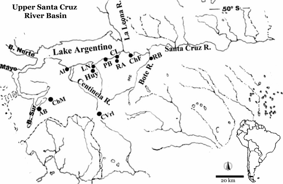
The Santa Cruz River is a perennial stream with a catchment area in the Andes cordillera. In the USCRB, water from snow and melting glacial ice first collects in Lake Argentino before flowing east into the Santa Cruz River. In the upper basin the Santa Cruz River has several tributaries, including the important Bote River (Figure 2). Human movement west of Lake Argentino both now and in the past has been limited by the extensive Southern Patagonia Ice Field, but the Pacific coast can be reached via passes through the Baguales Range (up to about 1,800 m asl), located south of the lake.
Map showing the locations of sites in the upper Santa Cruz River basin that are mentioned in the text. AB: Alero del Bosque; ChM: Chorrillo Malo 2; CVrl: Cerro Verlika 1; Al: Alice 1 and 2; LN: Laguna Nimez 1; Huy: Huyliche 1; PB: Punta Bonita 2; CL: Campo del Lago; RA: Rincón Amigo; ChF: Charles Fuhr 2; RB: Río Bote 1 and 2.

The present climate is cold semiarid, with precipitation mostly produced by disturbances embedded in the flow of the southern westerly winds (SWW) across the Andes. Precipitation is greatest on the windward slopes of the Andes and decreases west-to-east on the eastern, lee side (Garreaud et al. Reference Garreaud, Vuille, Compagnucci and Marengo2009). This gradient is visible in the vegetation, which shifts from Nothofagus forests in the west to steppe in the east. Variations in the position and intensity of the SWW have brought varying conditions of humidity and aridity to the area, with stronger winds generally bringing more precipitation to the westerly slopes of the Andes but less to the eastern slopes and steppe (Garreaud et al. Reference Garreaud, Vuille, Compagnucci and Marengo2009; Moy et al. Reference Moy, Moreno, Dunbar, Kaplan, Francois, Villalba, Haberzettl, Vimeux, Sylvestre and Khodri2009).
At a regional scale, paleoenvironmental information shows an antiphase relationship in moisture availability between the forest communities and the extra-Andean steppes throughout the Holocene (Mancini Reference Mancini2009). At sites west of Lake Argentino, forest expansion began during the Early Holocene in Andean areas (Villa-Martínez and Moreno Reference Moreno2007; Wille and Schäbitz Reference Wille and Schäbitz2009).
Tonello and coauthors (Reference Wille and Schäbitz2009) have shown that the longest, more or less continuous, period of increased moisture in the Andes during the Holocene was from circa 4800 to 2900 BP. Pollen records from extra-Andean Patagonia indicate lower moisture availability in the steppe at this time, particularly at circa 3750 BP, when carbonate deposits at Laguna Cháltel, about 80 km northeast of RB1, record desiccation of the lake basin (Ohlendorf et al. Reference Ohlendorf, Fey, Massaferro, Haberzettl, Laprida, Lucke, Maidana, Mayr, Oehlerich, Mercau, Wille, Corbella, St-Onge, Schabitz and Zolitschka2014). Pollen from Chorrillo Malo 2, a rockshelter west of Lake Argentino (Figure 2), records a grass-shrub steppe with intermediate levels of moisture between circa 5800 and 3000 BP (Mancini Reference Mancini2002).
From circa 3050 to 2250 BP, precipitation declined steadily in the Andes and increased in the steppe before these precipitation trends abruptly reversed around 1900 BP. The period of higher precipitation in the Andes and lower precipitation in the steppe was short-lived, however, and soon after 1900 BP there was an overall but irregular decline in moisture in the Andes and an increase in moisture in the steppe until circa 800 BP (cal AD 1250; Ohlendorf et al. Reference Ohlendorf, Fey, Massaferro, Haberzettl, Laprida, Lucke, Maidana, Mayr, Oehlerich, Mercau, Wille, Corbella, St-Onge, Schabitz and Zolitschka2014; Tonello et al. Reference Tonello, Mancini and Seppä2009). Evidence indicates drier conditions in the Andes and foothills prior to cal AD 1225, during the Medieval Climatic Anomaly (MCA; Stine Reference Stine1994). The period 700–180 BP (cal AD 1350–1800), corresponding to the Little Ice Age (LIA) in Patagonia, was mainly drier in the Andes and wetter in the steppe.
Archaeology of the Upper Santa Cruz River Basin
Previous archaeological research in the USCRB has focused on human peopling of the area and the role of the river as a frontier between human groups (Belardi et al. Reference Belardi, Borrero, Campan, Carballo Marina, Franco, García, Horwitz, Lanata, Martin, Muñoz, Sebastián Muñoz and Savanti1992). Most research has taken place in the lowlands surrounding Lake Argentino (Figure 2) and has provided evidence of human presence as early as circa 9700 BP at the Chorrillo Malo 2 archaeological site (Franco and Borrero Reference Franco, Borrero, Bonnichsen, Miotti, Salemme and Flegenheimer2003). Occupation was discontinuous until circa 3800 BP, when both highlands (1,100 m asl) and lowlands (250 m asl) were used (Franco Reference Franco, Civalero, Fernández and Guraieb2004, Reference Franco, Borrero and Franco2008; Franco and Borrero Reference Franco, Borrero, Bonnichsen, Miotti, Salemme and Flegenheimer2003; Franco et al. Reference Franco, Cirigliano, Ambrústolo, Borrero and Borrazzo2011). Raw material and technological information suggest that these areas were integrated within the home range of a single cultural group (sensu Bar-Yosef Reference Bar-Yosef2004) between circa 3800 and 1800 BP (Franco Reference Franco, Civalero, Fernández and Guraieb2004; Franco et al. Reference Franco, Cirigliano, Ambrústolo, Borrero and Borrazzo2011).
The Río Bote 1 (RB1) Archaeological Site
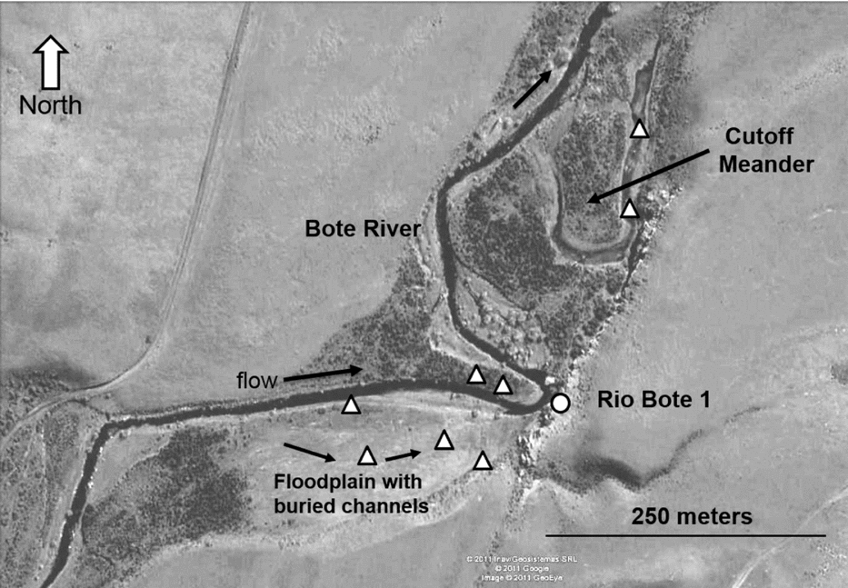
RB1 is a rockshelter in a cliff on the east side of the lower Bote River, which has its headwaters in the Baguales Range. It is subject to seasonal flooding in spring due to snowmelt at higher elevations (Figure 2). Before it joins the Santa Cruz River, the Bote River meanders along a flat-floored, narrow valley with several cutoff meanders (Figure 3). Bedload varies up to 1 m in diameter, attesting to the magnitude of seasonal flooding.
Google image showing landforms in the Bote River valley near the RB1 archaeological site. To the north of RB1 is a major cutoff meander and to the west a relict floodplain with ancient buried channels. Triangles show sites where fluvial sediments were obtained for radiocarbon or OSL dating. Arrows identify the cutoff meander or indicate the flow direction of the meandering river and buried channels in the floodplain. Figure 2 shows the location of Figure 3 and RB1 relative to the Santa Cruz River and Lake Argentino.

Sediments in the RB1 rockshelter are more than 2.5 m thick and clearly layered. Erosion on the outside of a meander in the river has exposed a stratigraphic section with clear evidence of human burials. The morphology of the RB1 sediments and the presence of submerged sandstone blocks several meters in diameter in the river adjacent to the site are strong indications that the roof and walls of the present rockshelter, and the sediments it contains, used to extend further west toward the river. This evidence, and the discovery of two incomplete skeletons projecting from the sediment face, suggested that the remaining sediments and the archaeological material they contained were in imminent danger of being eroded by seasonal floods. Because of this, archaeological research focused on the recovery of the human skeletons and associated cultural materials, while the paleoenvironmental research examined the history of the site and the area nearby.
A total of 10 skeletons were recovered from the site, eight of which (Individuals A, C, E, F, G, H, I, and J) were distributed in three cultural pits, one nested into the other, dated between 3800 and 3600 BP. They were mostly primary burials in anatomical positions, except for Individual E, whose bones seem to have been displaced when a fourth pit for Individual B, dated circa 2200 BP, was dug on top of the three previous pits. Although some isolated bones were identified as Individual D during the fieldwork, during lab work they were matched to either Individuals E or B. Lastly, on top of the sediment strata, but 2.5 m to the north of this column of burials, an isolated human mandible was identified as Individual K. A more detailed description of the field and lab methods employed in the recovery and the first osteological analysis of these burials is presented below.
Methodology
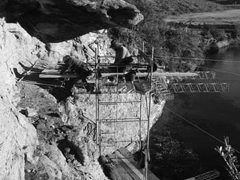
Excavation followed sediment and cultural boundaries in the deposit but was difficult and slow because the fragile nature of the sediment sequence dictated that work had to be conducted from a 3 m high scaffold built out into the river (Figure 4). Sediment and pollen samples were collected from the archaeological site and from fluvial deposits in the adjacent valley to develop a paleoenvironmental history for the area. Chronological information for the paleoenvironmental record was obtained by accelerator mass spectrometry (AMS) radiocarbon (organics) and optically stimulated luminescence/infrared stimulated luminescence (OSL/IRSL) (quartz and feldspar sand) dating of sediments in the floodplain and buried or abandoned river channels near the site. Techniques used in pollen and OSL/IRSL analysis are outlined in Faegri and Iversen (Reference Faegri, Iversen and Wiley1989) and Tripaldi and colleagues (Reference Tripaldi, Zárate and Brook2011), respectively.
Excavating the RB1 sediments from a scaffold. Note the width of the sediment sequence when the site was discovered.

Because most human burials were found as primary inhumations with their bones in anatomical position, each skeleton and each bone was mapped in three dimensions, allowing exact orientations to be determined. In the few cases when unarticulated bones were found in a pit, this procedure aided in the identification of their provenience during laboratory work (for example, bones mapped as individual D that then turn out to belong to either B or E).
All human bones were examined in the laboratory to determine the condition of the skeletons, the minimum number of individuals, and their probable sex and age at death. The few isolated bones recovered were matched to particular skeletons on the basis of the absence of that element in the skeleton and spatial proximity to a particular skeleton mapped during excavation, as well as bone morphology, age, and taphonomy. Sex and age determinations for adults were based on the classic methods compiled by Buikstra and Ubelaker (Reference Buikstra, Ubelaker and Haas1994); the use of one or more of these protocols depended on the completeness and preservation of the bone structures. Age estimates for subadults were based on the sequence of tooth development and eruption, the appearance and fusion of secondary centers of ossification, and long bone length (in perinatal and infantile remains), following data compiled by Scheuer and Black (Reference Scheuer and Black2000). No attempt was made to determine the sex of subadults.
A chronology for the burials was developed by direct AMS radiocarbon dating of human bone, supplemented by ages for charcoal, guanaco (Lama guanicoe), and choique (Pterocnemia pennata) bones also found in the cultural layers. Radiocarbon ages are given in years BP. Ages for human bones were calibrated at the two standard-deviation probability level using CALIB 7.1 (Stuiver and Reimer Reference Stuiver and Reimer1993) and the Southern Hemisphere (SHcal13) atmospheric calibration curve (Hogg et al. Reference Hogg, Hua, Blackwell, Buck, Guildersno, Heaton, Niu, Palmer, Reimer, Reimer, Turney and Zimmerman2013). They are given either in calendar years BP (cal BP) or calendar years AD (cal AD). Ages less than about 1200 BP, which are more relevant to readers who know about the MCA and LIA and have explored human behavior related to them, were also calibrated. OSL/IRSL ages are given in thousands of years BP (ka BP).
Results
Geomorphology and Paleoenvironment
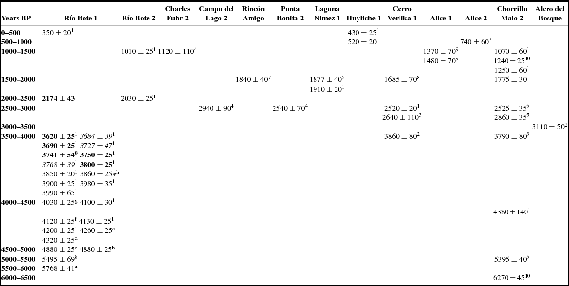
The RB1 sediments consist of basal fluvial silts deposited prior to 5768±41 BP (Table 1), overlain by coarser, more variable deposits transported to the site by wind action, slope wash, and breakdown of the cross-bedded sandstone, and Ostrea layers that form the roof, walls, and floor of the rockshelter (Figure 5). This shift from fluvial to other sediments implies a transition from moist to drier conditions at the site at this time. OSL and radiocarbon ages for fluvial sediments near RB1 demonstrate greater river flow from circa 5800 BP (age for basal fluvial sediments at RB1) to circa 5000 BP (feldspar IRSL age of 5.31±1.01 ka BP for coarse sediments approximately 28 m west of RB1 at 65 cm depth; UGAOSLAr11-1), when the river channel was west of its present position. Drier conditions at circa 3000 BP are indicated by a major, approximately 5 m thick sediment deposit 3 km upstream of RB1, with a quartz sand OSL age at 3.2 m depth of 2.95±0.4 ka BP (UGAOSLAr09-3), and a feldspar sand IRSL age of 2.55±0.35 ka BP at 5 m depth (UGAOSLAr11-3). These ages are identical statistically, and appear to record a possibly short period of severe drought when river flow was not sufficient to transport sediments from the channel. Sometime after approximately 3.0 ka BP, precipitation increased and the river was able to incise the valley fill sediments. Increased discharges from circa 1200 to 500 BP are indicated by ages of organic-rich sediments in buried channels in floodplain sediments south of RB1, with ages of 1210 ± 30 BP (UGAMS03068; δ13C ;= −27.12‰), 860 ± 25 BP (UGAMS03072; δ13C = −26.08‰), and 530 ± 25 BP (UGAMS03069; δ13C = −26.04‰). The channels are buried by more than 2 m of vertical accretion floodplain sediments, suggesting slightly reduced streamflow after around 500 BP but with occasional flash floods, one of which produced a cutoff meander north of RB1 that is filled with organic-rich sediments dating to 420±25 BP (UGAMS 03070; δ13C = −26.81‰). These increased discharges focused the channel on the RB1 cliff site at circa 1.89 ± 0.23 ka BP (feldspar IRSL age UGAOSLAr11-2 from 75 cm depth), undercutting the sandstone wall between the river and the sediments in the rockshelter. This protective wall eventually collapsed into the river, leading to the erosion of the exposed shelter sediments. Pollen from RB1 confirms the fluvial evidence, recording a transition from grass-shrub steppe when the fluvial silts were deposited under wetter conditions (before circa 5800 BP) to drier shrub steppe that predominated from circa 5800 to 4000 BP, when moisture conditions were probably similar to today.
Archaeological Sites in the USCRB with Middle and Late Holocene Ages.

Notes: Archaeological sites are listed from east (left) to west (right). Ages in bold type were obtained from human remains. Ages in italics were obtained from materials above rocks covering the human bodies.
Source references: 1 Franco et al. (Reference Franco, Brook, Mancini and Vetrisano2016), 2 Franco et al. (Reference Franco, Borrero, Belardi, Marina, Martin, Campan, Dubois, Stadler, Llosas, Cepeda, Muñoz, Borella, Muñoz and Cruz1999), 3 Franco and Borrero (Reference Franco, Borrero, Bonnichsen, Miotti, Salemme and Flegenheimer2003), 4Carballo Marina et al. (Reference Carballo Marina, Borrero, Franco, Belardi, Horwitz, Muñoz, Campan, Martin, Borella, García, Muñoz, Savanti and Lanata1999), 5 Franco et al. (Reference Franco, Mehl, Otaola, Kornfeld, Vasil'ev and Miotti2007), 6 Franco (Reference Franco, Borrero and Franco2008), 7 Franco et al. (Reference Franco, Borrero and Mancini2004), 8 Franco (Reference Franco, Borrero and Franco2008), 9 Borrero et al. (Reference Borrero, Franco, Marina and Martin1998–1999), 10 Mehl and Franco (Reference Mehl, Franco, Salemme, Santiago, Álvarez, Piana, Vázquez and Mansur2009).
Lab codes; material dated; and δ13C values: aAA-83488; charcoal, δ13C=–22.5‰; b UGAMS-11059, charcoal, δ13C=–22.1‰;cUGAMS-11060, charcoal, δ13C=–22.6‰;d UGAMS-11061, charcoal, δ13C=–22.1‰;e UGAMS-11062, charcoal, δ13C=–21.4‰, f UGAMS-11063, charcoal, δ13C=–21.1‰;g UGAMS-11064, charcoal, δ13C=–22.9‰;h UGAMS-21776, Lama guanicoe bone, δ13C=–19.8‰
*Lama guanicoe natural bone.
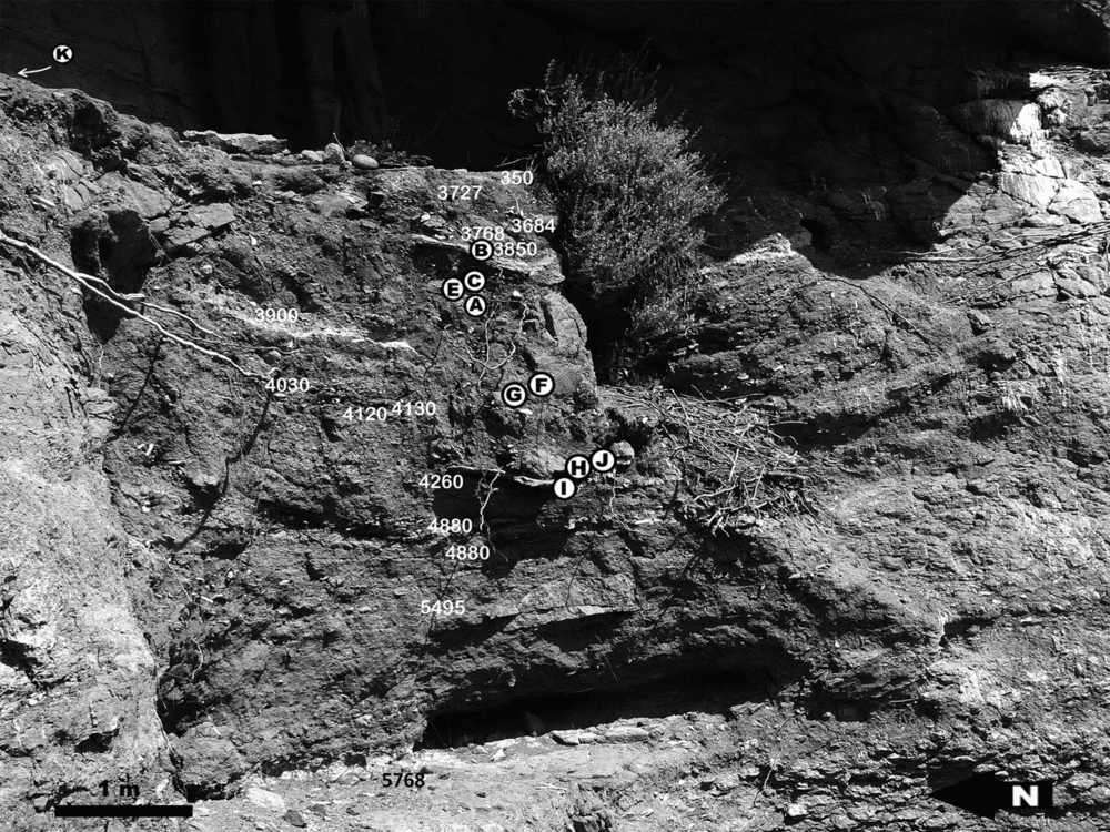
The RB1 sediment sequence showing burial pits 1–3, locations of human burials, and radiocarbon ages. The light gray Aguilera volcanic ash layer is visible in the upper part of the section to the left and right of the excavated burial pits (just below and to the left of individual A), which contained human remains.

Cultural Sequence
The earliest evidence of humans at RB1 is a small hearth, with associated lithics and faunal remains, in the upper part of the basal fluvial silts, dating to circa 5800 BP. The shelter was later used repeatedly, as indicated by a series of hearths and associated guanaco bones (with cut and percussion marks) and lithic artifacts, which are present at the site until the deposition of an Aguilera volcanic ash layer (ash identified by Charles Stern, personal communication 2008). Ages from the north-northeast part of the sediment sequence (to the left in Figure 5), where evidence of human activity is abundant, suggests that the volcanic ash was deposited over a cultural layer containing charcoal dating to 4030 ± 25 BP (UGAMS 11064; δ13C = −22.9‰). An age of 3900 ± 25 BP (UGAMS 7534; δ13C = −23.6‰) for charcoal found inside a bone tool in loose sediment within the ash also helps to date the ash fall. In the south-southwest (SSW) part of the sediment sequence (to the right in Figure 5), where there is less evidence of human disturbance, a guanaco bone from above the volcanic ash provided an age of circa 3860 ± 25 BP (UGAMS 21776; δ13C = −19.8‰). Together, these three ages suggest that the Aguilera volcano erupted and deposited ash at RB1 sometime between about 4030 and 3860 BP.
A lapa shell (Nacella magellanica) of marine origin, from deposits dating between 4800 and 4100 BP, suggests contact with the coast. There was a change in artifact technology by 4100 BP (Franco and Vetrisano Reference Franco and Vetrisano2014), when the extraction of elongated flakes was replaced by the Levallois method of obtaining flakes (Boëda Reference Boëda1993). The Levallois method continued to be used until around 3600 BP, when there is a gap in the RB1 sediment sequence (see Table 1). There is evidence, however, that the Levallois method was used at other sites in the area during this interval (Franco and Vetrisano Reference Franco and Vetrisano2014; Franco et al. Reference Franco, Borrero, Brook, Mancini, Robinson and Sellet2017).
Pits excavated into the rockshelter floor above the Aguilera ash contained multiple human burials, with individuals dated between circa 3800 and 3620 BP (Table 1). These burial pits cut previous cultural deposits dated between 4200 and 3900 BP, as shown by the ages for charcoal and guanaco bones (Table 1; Figure 5). The burial pits are covered by flat rocks and there are cultural deposits above them. Charcoal and choique and guanaco bones from these cultural deposits date them between circa 3760 and 3680 BP (Franco et al. Reference Franco, Guarido, Guraieb, Martucci, Ocampo, Bárcena and Chiavazza2010). The dates are in the same chronological range as the burials, suggesting that these activities were probably penecontemporaneous with one or more of the younger burial events. Higher in the sediment profile, there is an isolated burial near the rear of the rockshelter dating to circa 2100 BP. Evidence of human occupation after this is scarce but does include a hearth dated at circa 350 BP (Franco et al. Reference Franco, Borrero, Brook, Mancini, Robinson and Sellet2017).
Human Burials
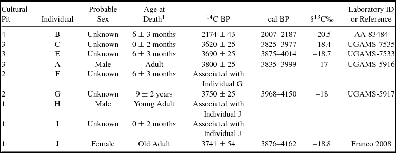
The remains of 10 individuals were recovered from RB1, most with their bones articulated in anatomical position. Bones from eight individuals (A, C, E, F, G, H, I, and J) provided ages between circa 3800 and 3600 BP (Table 2; Figure 6). These eight individuals were located in at least three cultural pits, the first excavated in older cultural deposits and the other two dug at the same location into the fill of the earlier pit. The pits also contained lithic and bone tool artifacts and faunal remains, some of which may be associated with the human skeletons. A Fissurella sp. bead, of marine origin, was recovered from a bird's nest adjacent to the burials. It is polished and has ochre (Mikel Zubimendi, personal communication 2009) and was probably deposited with the original burials.
Sex, Age at Death, and Radiocarbon Ages of Individuals from Cultural Pits 1 to 4.

Note: 1Adults were classified as Young, Middle or Old (sensu Buikstra and Ubelaker Reference Buikstra, Ubelaker and Haas1994).
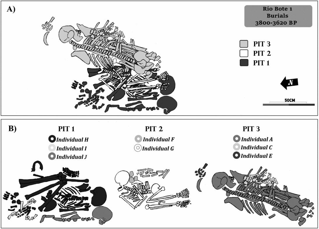
Human skeletons from the multiple burials dated between 3820 and 3600 BP.

The deepest dug pit (Pit 1) contained three individuals (H, I, and J) and was partly covered with large blocks of sedimentary rock 25–30 cm thick. Female adult J (Table 2) lay on her left side over a thin ash deposit and was partially exposed due to river erosion of the lower part of the sediment profile. The skull, some ribs, vertebrae, and bones of the upper left limb were recovered in situ; the right humerus was found on the ground next to the river. There were also some vegetal remains under this individual. Under the skull was a large, thick, endscraper made of local dacite, with red pigment on its ventral side; it was larger than other endscrapers we recovered from the area (Franco et al. Reference Franco, Guarido, Guraieb, Martucci, Ocampo, Bárcena and Chiavazza2010).
Lying on the same deposit, and clearly associated with J, were the remains of perinatal Individual I (Table 2; Figure 6). Some bones were projecting from the profile and were recovered during the first rescue fieldwork (May, 2008); the rest of the skeleton was excavated the following season (February–March, 2009). Bones of the upper and lower limbs, ilia, and ribs were recovered. Individual H, a young male adult (Table 2), was in the same pit, at the same depth, and close to Individuals J and I. The skull was upside-down and the mandible was close to the pelvis. The rest of the skeleton was in anatomical position, oriented southeast-to-northwest, and lying on its back, with legs flexed over the thorax (Figure 6). The left side of the thorax, left humerus, and feet were lying on a thin ash layer. An accumulation of rocks (large cobbles, some of sandstone) covered the lower limbs and parts of the trunk. The three skeletons had ochre on their surfaces, mainly goethite, according to X-ray diffraction studies, which would have been placed directly on the corpses or on something covering them (such as an animal- hide cape), as indicated by the very small amount (less than 5%) of pigment found in the sediments surrounding the skeleton (Franco et al. Reference Franco, Guarido, Montenegro and Ambrústolo2012). There were also grass remains beneath Individual H.
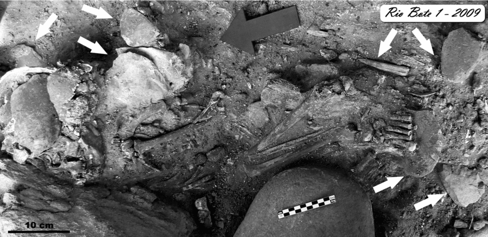
Pit 1 appears to have been reexcavated later in order to bury two subadults, G and F, who are separated from the previous burials by flat rocks (Pit 2). Individual G (Table 2) was oriented north-to-south and lay in a flexed, articulated position on the right side (Figure 6). The skull faced west. There was ochre on the skull; some pigment was also found on the thorax and lower and upper limbs (Guarido Reference Guarido2014). Artifacts were found in association with this individual, including a bone instrument and a lithic sidescraper, found beneath a foot (Figure 7). Individual F was very close to G and was also oriented north-to-south and on its left side, facing the ground. There was ochre on the bones (Guarido Reference Guarido2014) and charcoal nearby. Radiocarbon ages for Individuals G and J (Table 2) are statistically the same, although their stratigraphic position suggests that G was buried after Individual J. Nevertheless, both appear to have died and been buried within a relatively short period. Pit 2, containing Individuals G and F, was dug into Pit 1 and reached the burial depth of Individual H, causing the displacement of the mandible and skull described earlier. The rest of this individual was in anatomical position.
Grave goods associated with Individual G in Pit 2. The goods are indicated by white arrows.

The last pit dug during this time period (Pit 3; Table 2) was closer to the back wall of the rockshelter and included Individuals A, C, and E (note that bones originally labeled as Individual D were isolated subadult specimens that were later assigned to Individuals E or B during laboratory work). Lithic artifacts and animal bones were recovered near the skeletons but without a clear association to them. Individual A is a male adult (Table 2) placed at the base of the pit. The skeleton was articulated and oriented northeast-to-southwest, with the skull facing east toward the back of the rockshelter; it lay on its ventral side with the legs tightly flexed under the thorax (Figure 6). There was ochre on the skull and hands (Guarido Reference Guarido2014). Perinatal Individual C lay over Individual A's ribs and was also oriented northwest-to-southeast (Figure 6). It was on its ventral side and the bones also had ochre on them. The bones of subadult E were not in an articulated position, but were bundled together close to the skull of Individual A. There was ochre on the bones and in the sediments around them. The upper part of this pit was also covered with rocks. We believe that Individual E was removed from its original position when a new individual (B; see below) was buried near the rear of the rockshelter more than 1,000 years later (Table 2).
Along with the dates for the human remains, three ages were obtained for the cultural deposits above the rocks covering the three excavated pits: two on faunal remains with cultural marks and one on charcoal. Guanaco and choique bones were dated to circa 3760 BP and circa 3700 BP, respectively, and charcoal to circa 3600 BP, suggesting they date to the time of the burials or soon after (Franco et al. Reference Franco, Guarido, Guraieb, Martucci, Ocampo, Bárcena and Chiavazza2010).
A partially complete subadult skeleton and an isolated adult mandible are evidence that two other individuals were buried at RB1. Subadult Individual B was buried in Pit 4 at the very rear of the rockshelter in sediment layers overlying the previous burials. This burial was also covered with rocks and there was ochre on the bones; it had been disturbed by rodent burrowing and part of a rodent mandible was found inside the skull. The skeleton dated to circa 2100 BP, making it the youngest found at the site (Table 2; Figure 5). The adult mandible (Individual K) was found approximately 2.5 m north of Pits 1–3 in disturbed sediments at the top of the sediment sequence, close to large rocks that could be part of another burial pit. The sediments are substantially eroded, however, and the mandible is possibly the only human remain left in this part of the sequence (Figure 5).
Discussion
Changes in the Utilization of Río Bote 1 through Time
There is scant evidence of human presence at RB1 or in the USCRB before about 5768 BP. At RB1, hearths are more abundant after about 4800 BP, following the period of very dry conditions that led to the desiccation of Laguna Cháltel. Associated with these hearths are abundant lithic artifacts and guanaco bones with cultural marks, suggesting that the site was used repeatedly for subsistence activities, a conclusion supported by our preliminary lithic and zooarchaeological analyses. In terms of morphology, technological characteristics, and raw materials, the lithic artifacts at RB1 are similar to artifacts of the same time period from Chorrillo Malo 2, a multiple activity site located about 95 km west of RB1 near the forest-steppe ecotone (Franco and Vetrisano Reference Franco and Vetrisano2014). Faunal assemblages are mostly composed of guanaco bones, with evidence of processing and consumption activities (María Victoria Fiel, personal communication 2016).
Between circa 4030 and 3860 BP, a major eruption of the Aguilera volcano in Chile deposited a layer of ash at RB1. After this, RB1 was used as a burial site, first between approximately 3800 and 3620 BP, and then again around 2100 BP. During the earlier period, at least three pits (Pits 1–3) were excavated at the same location in the floor of the rockshelter, with the younger pits penetrating the upper part of the older pit below. Each pit contained more than one individual, and both adults and subadults were identified. At least eight individuals were buried in these three pits, an exceptionally large number considering that these were in a narrow column of sediment at the rear of the rockshelter. Although many cultural materials (lithic and bone remains, including some tools) were found within the sediments filling the pits, only those in direct association with the human remains can be confidently considered grave goods. Common features of the burials are the presence of ochre on most of the bones and the absence of this pigment in the surrounding sediments (Franco et al. Reference Franco, Guarido, Montenegro and Ambrústolo2012). This, and the flexed position of most of the skeletons, suggests that individuals, particularly adults, may have been contained in some kind of painted organic wrapping such as a painted animal hide.
Above the rocks that covered the pits there were also lithic artifacts and animal bone fragments, mostly penecontemporaneous with the underlying burials (i.e., 3800–3600 BP). These could have been placed there when the pits were dug as funerary rites or, alternatively, they could have been left from activities that took place immediately after the burials. The lack of evidence of human occupation for more than one thousand years after the first group of burials (between circa 3600 and 2100 BP), as well as the strict contemporaneity of the dates, tends to support the idea that these cultural remains were related to funerary rites or to the excavation of the pits.
Evidence of human activity at the shelter is scarce after the 2100 BP burial, and the only date obtained so far comes from a hearth dated to around 350 BP, with scant associated lithic or faunal remains.
Río Bote 1 in the Upper Santa Cruz River Basin Archaeological Context
Comparison of the sequence of events at RB1 with events at other sites in the region (Borrero et al. 1998–99; Franco Reference Franco, Civalero, Fernández and Guraieb2004; Franco et al. Reference Franco, Borrero, Belardi, Marina, Martin, Campan, Dubois, Stadler, Llosas, Cepeda, Muñoz, Borella, Muñoz and Cruz1999) reveals differences in site function and chronology (Table 1). Between circa 5800 and 4300 BP, the only sites in the USCRB with signs of human use are rockshelters, namely RB1 and Chorrillo Malo 2 (Table 1; Figure 2). As previously noted, there are broad similarities in lithic technology at the two sites (Franco and Vetrisano Reference Franco and Vetrisano2014), with the Levallois method (sensu Boëda Reference Boëda1993) appearing at both sites between circa 4300 and 3800 BP. The bone technology is dated at around 3900 BP at RB1. This site shows an increased archaeological signal after about 4800 BP; it continued to be used until around 4030–3900 BP, after the eruption of the Aguilera volcano. Subsequently, remains of human activity are scarce and relate to the 3800–3600 BP burial activities at RB1. Chorrillo Malo 2, a rockshelter in the lowlands to the west, where the climate was slightly wetter than in the RB1 area, shows increased activity around 3800 BP, coinciding with the RB1 burials. The Cerro Verlika 1 rockshelter, located at approximately 1,100 m asl, in the Baguales Range (Table 1), was also used by humans around 3800–3600 BP.
The stronger signal of occupation at Chorrillo Malo 2 after 3800 BP is evidenced not only by an increase in the number of artifacts but also in the type of items recovered, such as grinding stones, some with ochre, abundant pigments, and raw materials such as gray-green banded obsidian, probably coming from the highlands (Franco Reference Franco, Civalero, Fernández and Guraieb2004; Stern and Franco Reference Stern and Franco2000). This evidence has been used to suggest that this period marked the beginning of the effective occupation of the USCRB (Franco Reference Franco, Civalero, Fernández and Guraieb2004). The multiple burials at RB1 (including adults and subadults) reinforce this interpretation. Scholars note the technological and raw material similarities among these three locations (including Cerro Verlika 1) to argue for their utilization by the same cultural group (sensu Bar-Yosef Reference Bar-Yosef2004; Franco Reference Franco, Civalero, Fernández and Guraieb2004, Reference Franco, Cirigliano, Ambrústolo, Borrero and Borrazzo2011; Franco et al. Reference Franco, Cirigliano, Ambrústolo, Borrero and Borrazzo2011).
The hiatus in use of RB1 after the multiple burials from 3800 to 3600 BP, until the single burial at around 2100 BP, contrasts with the regional evidence of site use. During this time, new open-air and rockshelter sites (Campo del Lago 1, Alero del Bosque, Punta Bonita 2) begin to appear in different environments (forest and steppe) west of RB1 (Figure 2; Table 1). Paleoenvironmental data suggest increased precipitation between about 3100 and 2800 BP in areas west of Lake Argentino, where most of these sites are located, contrasting with extremely dry conditions in the steppe to the east, where RB1 is located. RB1 may even have been abandoned during this arid period, which is recorded at Laguna Cháltel.
RB1 was not used between around 2100 and 350 BP during what may have been a relatively dry phase of climate in the area that lasted until around 600 BP (Franco et al. Reference Franco, Borrero, Brook, Mancini, Robinson and Sellet2017). In contrast, to the west, humans occupied open-air sites (Laguna Nimez, Alice 1, Charles Fuhr 2) and rockshelters (Chorrillo Malo 2 and Cerro Verlika 1) until around 1000 BP, probably because unlike the steppe, areas closer to the Andes experienced higher precipitation at this time. Between circa 1000 and 500 BP, areas close to the Andes were abandoned, probably because of arid conditions during the MCA (Borrero and Franco Reference Borrero, Franco, Belardi, Marina and Espinosa2000), which lasted from cal AD 130 to 1600. In both the eastern and western parts of the USCRB, archaeological evidence is scarce after the MCA, being limited to RB1, Rincón Amigo, Alice 2, and Huyliche 1, where a new kind of human burial is recorded south of Lake Argentino, namely the chenque (Figures 1 and 2).
In summary, the available evidence shows that there were three rockshelter sites in the USCRB that were used during the early and middle Late Holocene—Río Bote 1 on the steppe plateau, Chorrillo Malo 2 near the forest-steppe ecotone, and Cerro Verlika 1 in the highlands. At this time the climate was wetter at Chorrillo Malo 2 and more arid at RB1 to the east in the steppe. In contrast to the western sites, which were used in a variety of ways that did not include burials, RB1 was repeatedly used only for burial purposes during this time. It seems that RB1 was chosen specifically as a site to bury the dead between circa 3800 and 3600 BP and afterwards at around 2100 BP.
The Integration of Burial Information from RB1 and Spaces to the South
There are no human burials elsewhere in the USCRB comparable to those at RB1. Nevertheless, a similar funerary record is found at sites to the south and southeast of our study area. In the Pali Aike volcanic field, 260 km southeast of RB1 (Figure 1), five individuals (two adults and three subadults) were buried together in a single pit in the rear of the Orejas de Burro 1 (OB1) rockshelter (L'Heureux and Barberena Reference L'Heureux and Barberena2008). The bodies lay in a semi-flexed position, were covered with ochre, and had been placed on a layer of grass; after burial they were covered with rocks from the shelter. The burial was dated to around 3500 BP (L'Heureux and Barberena Reference L'Heureux and Barberena2008). The sediments filling the pit also contained isolated bones of at least one other individual from a previous burial (L'Heureux and Barberena Reference L'Heureux and Barberena2008). Earlier research in the 1970s found two individuals in a different pit in the central part of the rockshelter (Guerra de Fretes 1977 in L'Heureux and Barberena Reference L'Heureux and Barberena2008). Unfortunately, these skeletons have been lost (L'Heureux and Barberena Reference L'Heureux and Barberena2008). Hearths and abundant archaeological material were also recovered from the sediment filling the OB1 burial pit and from the sediments cut by it, indicating that the shelter was not used exclusively for funerary purposes (L'Heureux and Barberena Reference L'Heureux and Barberena2008). There was no evidence of subsistence activities during or immediately after the burials, however, as this type of use of the site is dated at around 1700 BP (Charlin Reference Charlin2009).
A similar multiple burial was excavated by Bird in 1936 at Cerro Sota Cave (CS), about 38 km west of OB1, in the Chilean part of the Pali Aike volcanic field (Figure 1). Three female adults and four subadults were buried at the rear of the cave; they were placed on grass and covered with local volcanic rocks and ochre (Bird Reference Bird and Hyslop1988). Posterior analyses by L'Heureux and Amorosi (Reference L'Heureux and Amorosi2010) identified a total of nine individuals, six from the burial at the back of the cave and another three represented by isolated bones from the anterior chamber of the cave. The burial at the back of the cave has usually been described as a cremation, although recent analyses found only partially or superficially burnt bones (L'Heureux and Amorosi Reference L'Heureux and Amorosi2010). Three dates for the burial range from around 3600 BP (Individual CS1; L'Heureux and Amorosi Reference L'Heureux and Amorosi2010) to around 3400 BP (Individual CS2; Hedges et al. Reference Hedges, Housley, Bronk and Van Kunkev1992).
A pit burial of three subadults and one adult was discovered in Cueva Lago Sofía 1 (CLS1), 145 km south of RB1 in the Última Esperanza region of Chile. According to Prieto (Reference Prieto1991), bodies were placed in the pit wrapped in guanaco hides with ochre. The pit was then filled with grass and Nothofagus pumilio bark that served as fuel for the cremation of the bodies. Two painted shells and a sidescraper covered with pigment were also recovered from the pit. The burial has been dated to around 3900 BP. The cave shows evidence of previous use, including the presence of extinct megafauna; ages for the bones of extinct and extant mammals, as well as charcoal, indicate use between circa 11,500–10,100 BP (Jackson and Prieto Reference Jackson and Prieto2005; Massone and Prieto Reference Massone and Prieto2004; Prieto Reference Prieto1991). There is no information on the use of the cave after the burials.
In summary, there were pit burials of multiple individuals inside caves or rockshelters in the period 3900–3400 BP at several locations south of RB1, up to 250 km. In all cases, there was the simultaneous inhumation of more than one individual, including both adults and subadults, in a burial pit covered with rocks, with abundant use of ochre. At most sites (RB1, OB1, and CLS1), the bodies were lying on their sides in a flexed position. At least two sites (CS and CLS1) show signs of burning as part of the funerary practice. There is also evidence that the pits were prepared in some way before the bodies were placed in them (for example, grass was placed either around the pit or around the bodies). None of the burials had abundant grave goods, but at RB1 and CLS1 there were either lithic artifacts, bone tools, or shells that may have been deliberately placed next to some of the bodies. These many shared characteristics suggest common or similar funerary practices among the hunter-gatherers of southern Patagonia during the early Late Holocene, as well as connections between eastern and western groups south of the Santa Cruz River, which were probably part of the same social unit (sensu Bar-Yosef Reference Bar-Yosef2004).
At least three sites (RB1, OB 1, and CS) have provided evidence of the reuse of the same rockshelter for more than a pit burial. Although these other events have not been dated at OB1 and CS, at RB1 there is evidence of use at the same time or shortly after burials as well as evidence of much later use for another burial (the subadult burial dated around 2100 BP). All three sites appear to have had other (probably domestic) use than the mortuary ones, but not at the same time the burials took place (Charlin Reference Charlin2009; L'Heureux and Barberena Reference L'Heureux and Barberena2008; Prieto Reference Prieto1991). In the case of RB1, faunal and lithic remains date to the time of the burials, and so could have been related to the funeral activities themselves or to the period immediately following them.
So far, no similar multiple burials have been found north of RB1, reinforcing the idea that during the early Late Holocene there was a stronger connection with groups south of the Santa Cruz River than with northern populations. This is also supported by lithic information (Franco et al. Reference Franco, Cirigliano, Ambrústolo, Borrero and Borrazzo2011). This situation changed during the last millennium when chenques became the most common burial type across Patagonia (Goñi et al. Reference Goñi, Barrientos and Cassiodoro2000–2002).
Río Bote 1 and the Debate about the Paucity of Human Remains during the Early and Middle Holocene in Southern Patagonia
Various hypotheses have been proposed to explain the paucity of Early and Middle Holocene funerary evidence for southern Patagonia. Some researchers have pointed to preservation issues and sampling biases as the main cause for the sparse record (Guichón et al. Reference Guichón, Barberena and Borrero2001). Others have proposed that the probable flexibility of mortuary behaviors, including cremation and the abandonment of bodies, particularly in the early stages of the human peopling of the region, would also have contributed to the paucity of human burials, particularly during the Late Pleistocene–Early Holocene transition (Barrientos Reference Barrientos, Martínez and Lanata2002; Dillehay Reference Dillehay2000). In all cases, the small number and high mobility of human groups during this period has been underscored.
The mortuary record at RB1, and similarities to burials further south during the early part of the Late Holocene, shed some light on the debate. In southern Patagonia, human burials appear to be concentrated in circumscribed points in space. Not only are there several human burials in a single rockshelter, but most of the burials are at the very same location (or very close to it) as previous burials within the shelters. RB1 is an extreme case of this situation, with eight individuals being buried in three pits dug one into the other. These burial characteristics minimize the spatial impact of the human burials that have been found, particularly in an area as large as southern Patagonia. The very low population densities in southern Patagonia during most of its prehispanic occupation history (and particularly during the Early and Middle Holocene) mean that the chances of finding multiple burial sites is even less likely. This suggestion is reinforced by the fact that the earliest burials in the region, such as those at Baño Nuevo in the Coyhaique region (around 9000 BP; Mena and Reyes Reference Mena and Reyes2001) and Piuquenes rockshelter (around 9100 BP), located farther to the north, in Chile (Stehberg et al. Reference Stehberg, Blanco and Labarca2005), were multiple burials in caves and rockshelters.
Conclusions
Throughout its occupational history, RB1 had two markedly different functions: first for subsistence activities, and then as a funerary site with several episodes of inhumation. Subsistence activities date from around 5800 to 3900 BP. After the Aguilera volcanic eruption (between about 4030 and 3860 BP), which left a distinctive layer of ash on the floor of RB1, the shelter was used repeatedly as a burial site, first between 3800 and 3600 BP and later at around 2100 BP, with a final isolated occupation for subsistence activities at around 350 BP. Hiatuses in the use of RB1, from about 3600 to 2100 BP, and from 2100 to 350 BP, occurred during times when paleoenvironmental information points to extreme aridity in the area. Although RB1 appears to have been abandoned from about 2100 to 350 BP, at a time of arid climate in the steppe in the east, both open-air and rockshelter sites in the west continued to be used for subsistence activities, probably because of the wetter conditions, at least until MCA times, when western areas were hit by a major period of drought leading humans to abandon the area.
Previous work on technological similarities in the area has shown that RB1 was in the home range of cultural groups using spaces to the west and south, including the area west of Lake Argentino and probably the Baguales Range, between about 4300 and 3600 BP. These similarities extend as far south as Cerro Castillo, south of the Baguales Range (Langlais and Morello Reference Langlais and Morello2009). Based on the new mortuary evidence from RB1, it is reasonable to argue that there were social connections with groups even further south, in the Última Esperanza region and Pali Aike volcanic field, as shown by strong similarities between the early Late Holocene human burials at the sites in these areas (Bird Reference Bird and Hyslop1988; Franco et al. Reference Franco, Cirigliano, Ambrústolo, Borrero and Borrazzo2011; L'Heureux and Barberena Reference L'Heureux and Barberena2008; Massone Reference Massone1996; Prieto Reference Prieto1991). It is worth noting that to date, not one burial site of comparable chronology has been located to the north, between the Deseado and Santa Cruz rivers.
Evidence presented here indicates that the selection of the same place for multiple burials may contribute to explaining why so few human burial sites are known in southern Patagonia prior to the early Late Holocene, as it is possible that sites like RB1 remain to be discovered.
Acknowledgments
We thank the National Geographic Society (grant 8397-08), University of Buenos Aires (UBACyT W1/0404 and 20020130100664BA), Cooperation Project CONICET-NSF 2014 (Resolution 3080), and the University of Georgia Research Foundation for financial support and the University of Arizona for their support for the first radiocarbon ages for RB1. We thank three reviewers whose comments helped us to improve the paper. We are also grateful for the help we received from Patrimonio Cultural de Santa Cruz, the owner of the ranch on which RB1 is located, from workers at the Río Bote ranch, and from local inhabitants, mainly Berni Roil and Gerardo Povazsan, and all the people who worked at the site.
Data Availability Statement
Additional data can be obtained by request from the authors.