

1. Introduction
In 1997, the British Library purchased a codex containing a total of 50 maps.Footnote 1 By 2013 scholars were agreed on the dating and the likely identification of the person who first compiled the collection of maps. The British Library digitalized the maps in the codex and on the website, stated it “was put together in the early 1570s by the Flemish cartographer Gerardus Mercator … to help with planning the grand tour of Europe of his patron’s son, the Crown Prince of Cleves.” Footnote 2
Beginning more than a decade before the purchase and represented in the publication of the first volume of The History of Cartography, historians of cartography have been reconceptualizing the relationship among person, object, and topography – that is, among a viewer, a cartographic representation in a range of different media, and the physical experience of the surface of the earth (Harley and Woodward Reference Harley and Woodward1987; Harvey Reference Harvey1980; Cosgrove Reference Cosgrove2008). That change in understanding, among other things, calls into question any notion of “planning” a trip using any sixteenth-century cartographic representation: the values with which modern users approach cartographic representation differ (Cosgrove). This essay argues that, given the available evidence and foremost the evidence of the object itself, the codex of maps could have been compiled to teach the Crown Prince of Jülich-Cleves-Berg, the son of Mercator’s patron, practices of spatial imagination while he was making his trip to Italy. It argues, in other words, that the maps could have been compiled to teach a prince ways of conceptualizing space through different representations of topography, ways that, in turn, might inform his rule.
This essay posits a concept of practices of spatial imagination, drawing, in particular, on Michael Baxandall’s concept of the “period eye” (Baxandall [1972]Reference Baxandall1988) and Denis Cosgrove’s concept of “mapping” (Cosgrove Reference Cosgrove1999, Reference Cosgrove2001, Reference Cosgrove2008). Following Baxandall, the concept of practices of spatial imagination distinguishes objects that may survive over time from the persons who view them, who exist in historically (as well as socially, religiously, and geographically) differentiated epistemologies—systems of knowledge and disciplines of perception. Practices of spatial imagination are historical. The objects, in other words, do not “contain” knowledge, do not “transmit” knowledge, do not “represent” one way of imagining space. They teach contingently – in a particular moment, with its specific knowledge cultures and mapping practices, the eyes and mind of a historically specific person. Following Cosgrove, maps and atlases teach contingently in another way as well: they teach ways of conceiving space in dialectic with stasis or movement. Maps and atlases are prompts for practices of spatial imagination from which person and motion cannot be separated.
2. The Object
This is a study in how a single object, a compilation of maps, could have taught one very specific youth, the heir to one of the great principalities of early modern Europe, ways of thinking about his domain. The codex contains a total of 50 maps: “a set of nine plates taken from various copies of Gerardus Mercator’s 1554 wall map of Europe; a set of six plates from copies of Mercator’s 1564 wall map of the British Isles; two plates from Mercator’s large world map of 1569; two manuscript maps; thirty maps from the Latin edition of Ortelius’s Theatrum Orbis Terrarum of 1570 and an urban plan of the city of Ancona” (Watelet Reference Watelet1998, 7). The codex is not the product of a single process: 2 maps are manuscript, 48 are printed; of the printed maps, 31 were originally printed in folio size, and 19 were cut from wall maps, much larger in size, and then pasted to form folio-sized pages (Watelet Reference Watelet1998; Barber Reference Barber2013). According to an index appearing before all the maps, written by Alarius Ortmans, a Cistercian monk, in the eighteenth century, Ortmans “renovated” and “redacted” the codex in 1771.
The codex presents an unusual array of puzzles. There is no written record of the codex prior to 1967, when it was discovered in a used bookstore in Belgium (The Mercator Atlas of Europe 1996, 23; see also Varekamp Reference Varekamp1970; The Mercator Atlas of Europe Reference Watelet1998; Barber Reference Barber2013). Nothing in the object itself explicitly states its origins, not the hand that drew two of its maps, nor the hands that compiled printed maps from multiple sources, nor the hand that numbered some of the pages, nor the hand that labeled some of the maps. None of the maps bear the signature of a draftsman, designer, or printer.
In 2013, Peter Barber, Head of Map Collections at the British Library, succinctly summarized the state of scholarship on the codex and offered an amendment to the dating of the codex, further evidence to support Marcel Watelet’s earlier hypothesis of its intended recipient, and Barber’s own hypothesis as to the original sequence of the maps (Barber Reference Barber2013). Barber excluded the map of Ancona from the original codex and dated the original compilation “after 1569 but before 1572 when Mercator published his wall map of Europe” (Barber Reference Barber2013, 13).
3. “Reading” the Codex
From its discovery in 1967, the codex has been called an “atlas,” thereby obscuring a key moment in the history of maps and their uses. “Atlas” now is a common noun naming “a collection of maps in a volume,”Footnote 3 so pervasive and familiar have both maps and a particular mode of materialization become. Mercator first put the word on the title page of a codex of maps his heirs published posthumously in 1595; before that date, other words, and with them, other ways of conceptualizing a codex of maps were in circulation, most famously, Ortelius’s Theatrum Orbis Terrarum.
Binding maps together in a codex, of a uniform size, folio or smaller, at once protected by a binding and portable, was rare before Ortelius sought to market a codex of maps in 1570. There is evidence that individuals bound maps together in codices for their private use, and portolan charts – modes of visualization used by navigators – were bound in codices. Ortelius’s Theatrum was the first published codex of maps produced for widespread and variegated consumption (Abraham Ortelius and the First Atlas Reference Broecke van den, van der Krogt and Meurer1998; Images of the World Reference Wolter and Grim1997).
The word, “atlas,” not only names a particular kind of object, but the use of the word to name an early modern object attaches modern connotations to that object, foremost that it is something commonplace – something that could be found in any classroom – and connects the codex to a range of practices of spatial imagination that postdate it, including the imagined relationship among person, topography, and representation implicit in a notion of “planning.” Ptolemy had sought such a system of matrices, of lines of longitude and latitude, within which every place could be plotted, its precise coordinates determined mathematically (Dilke Reference Dilke1998). But he did not possess all the necessary information: longitude would only be determined long after the sixteenth century.
“Planning” rests on an assumption about practices of spatial imagination – that those practices are consistent historically and geographically. It rests on one specific conceptualization of the relationship among eyes or person, representation or map, and topography. That conceptualization, in turn, rests in part on the assumption of a uniform system of measurement which renders all space at once abstract – not governed by topography but by mathematical formula – and measurable in the same units used everywhere by every person. At the time that scholars believed the British Library codex to have been created and compiled, there was no consistent or uniform system of measurement. There were no instruments of common measurement (Lindgren Reference Lindgren and David2007, 489-90). Surveying remained a local practice, using instruments calibrated to local units of measurement. Indeed, in one of the cartouches on his world map of 1569 Mercator claimed to be the first to calculate “so that the siting of locations corresponds as much in true direction and distance as in longitude and latitude as in relationship to one another; as well that the [figurae] of regions appearing on the sphere, insofar as it is possible, be preserved. Towards this [end] this work sets meridians to parallels in a new relationship.”
The British Library codex belongs to a pivotal moment in the history of cartography and travel. The first “route book,” a collection of calculations of distance between cities, each conceived as a point in a line with another city, was published in 1563 (Krüger Reference Krüger1974). That codex contained lists, hundreds of distances calculated in units of days between points on itineraries that merchants traveled. Its spatial imagination was linear (Delano-Smith Reference Delano-Smith and Ackerman2006); its measurement temporal. In that same year, Philipp Apian produced his map of Bavaria, in which he applied mathematical principles to establish distances on the plane of the map (Die Vermessung Bayerns 2013).
Key practices we now associate with the use of maps – consistent systems of measurement, conventions for representing topographical information – postdate the British Library codex. Indeed, it was compiled in exactly the period when cartographers, merchants, navigators, and mathematicians were seeking, but had not yet formulated, a system for determining distances that was both consistent and could be applied universally (Snyder Reference Snyder1993, 1-54; Snyder Reference Snyder and Woodward2007; Ptolemy’s Geography in the Renaissance Reference Shalev and Burnett2011). Given the dating and that Mercator is the compiler, then the modes of visual representation he gathered in the codex were new, some startlingly so. The codex does not tell us in words, how we are to read it, but we can set aside practices of spatial imagination that postdate it and turn to it with eyes historically informed. The British Library codex was created for a different purpose. That purpose begins with the question of the eyes for which it was intended (Baxandall [1972]Reference Baxandall1988).
4. Eyes
There survive as well no paratexts to suggest the codex’s original recipient. Watelet and Barber both support the thesis that it was created to accompany the Crown Prince of Cleves on his trip to Italy in the years 1574-75. That argument rests on the dating of the maps contained in the codex and on the identification of Mercator not only as the designer of the wall maps from which 17 maps had been composed, but also as the hand that drew the calligraphy in the two manuscript maps and added scales and labels to the 17.
Watelet and Barber have argued for Werner von Gymnich, Marschall of the Duchy, as the intended recipient, primarily along two constructed lineages, of provenance and patronage (Watelet Reference Watelet1998, 7; Barber Reference Barber2013, 18-19). The argument for provenance constructs a transferal of the codex from the von Gymnich family to the monastery for which we have the first textual evidence, but even if the codex came to the library through this family, there is no textual evidence that von Gymnich was the original intended recipient. The same argument can be made, were he to have received the codex in the wake of the Crown Prince’s early death. The argument for patronage rests on Mercator’s correspondence with von Gymnich, but nowhere in that correspondence have Watelet or Barber found mention of the codex.
The case for the Crown Prince also rests on patronage. It begins with the kinds of hands into which we know Mercator sought to place his maps. Mercator dedicated his path-breaking 1569 world map to his patron, the Duke of Jülich-Cleves-Berg. Mercator also dedicated his major cartographic publication, the Atlas, to “the Most Illustrious and Most Clement Princes, Wilhelm and Johann Wilhelm, Dukes of Jülich, Cleves, and Bergen, Counts of Marchia and Ravenburg, Lords in Ravenstein, etc., Father and Son, His Most Clement Lords.” The Gallia, published in 1585, carried a dedication to Johann Wilhelm, Crown Prince at the time, who was to become Duke in 1592. The Belgii Interioris and the Germania, both published in 1585, carried no dedications, but both opened with a consideration of politics, and the Germania opened with a sketch of the organization of the Holy Roman Empire, “whose head is the Emperor,” who was also the brother of the Duchess of Jülich-Cleves-Berg. The Italiae, Sclavoniae, et Graeciae tabulae geographicae, published in 1589, was dedicated to “Serenissimo Principi D. D. Ferdinando Medici, S. R. E. Cardinali, Magnoque etruriæ Duci, Hispaniarum Protectori.” A codex now in the Maritiem Museum in Rotterdam, composed from Mercator’s world map of 1569, retains that map’s dedication to the Duke of Jülich-Cleves-Berg (Atlas van de Wereld: De wereldkaart van Gerard Mercator uit 1569, Reference Mercator and de Meer2011, Plate 2). Mercator dedicated his Atlas, his major work of cartography, to the father of the Crown Prince who traveled in 1571-75, and to his surviving brother. If in one of his surviving letters Mercator asked von Gymnich for information from his travels (The Mercator Atlas of Europe 1996, 24), Mercator dedicated his maps, and in particular, his codices of maps, to the heads of courts, not members of those courts. Not only is it plausible that Mercator compiled these maps for his patron’s heir, but as that heir was about to embark on politically important travel, it is also plausible that Mercator intended the Crown Prince would thus carry Mercator’s maps into many of the major courts of Europe.
5. Maps and Princes
In 1988, J.B. Harley wrote, “The history of the map is inextricably linked to the rise of the nation-state in the modern world” (Harley Reference Harley and Laxton1988, 59). In a series of Kenneth Nebenzahl Jr. lectures in 1985, published in 1992, a number of scholars, however, demonstrated that that particular relationship of spatial representation and political power postdates the sixteenth century. As John Marino wrote in “Administrative Mapping in the Italian States”:
Maps appear only sporadically before 1560 in the state archives of Venice, Florence, and Naples and in published collections from Milan and the Vatican. Mapping as a normal administrative way of looking at the world dates only from the third quarter of the sixteenth century, at the same time that technical changes in mapmaking and map publishing transformed the market for cartographic products. (Marino Reference Marino and Buisseret1992, 5)
In Habsburg lands, James Vann argued, the early modern Habsburgs’ understanding of their political power as both personal and dynastic, also shaped their approach to mapping:
just as their national politics were highly personalized and local, so too were their mapping commissions. Yet the Habsburgs made good use of maps for local military strategy, for religious devotion, and for political propaganda, especially as regards the dynasty. (Vann Reference Vann and Buisseret1992, 158)
Before the seventeenth century, atlases and maps were not the familiar instruments of administration that they were to become. Rulers, as Vann wrote, conceived of their domains in personal, even somatic terms.
The relationship of maps to the education of princes was changing in the time the codex was compiled. Humanists such as Thomas Elyot argued that princes should be introduced to Ptolemy’s maps “to prepare the childe to vnderstandynge of histories,” while Juan Luis Vives called for students literate in Greek and Latin to study Strabo and Ptolemy for geography (Cormack Reference Cormack and David2007, 626-27). In the education of princes, if an author called for the use of maps, it was to supplement an education in classical authors, including “histories” and Ptolemy’s tables (Cormack Reference Cormack and David2007). Among humanists who wrote the most influential treatises on the education of princes in the fifteenth and sixteenth centuries, the overwhelming emphasis was on texts (Édouard Reference Édouard2014; Meyer Reference Meyer2004); maps served those texts (Cormack Reference Cormack and David2007). Those maps were not governed by the principle of representation Mercator expressed in 1569.
6. The Education of the Crown Prince: The Trip to Italy
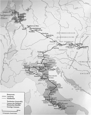
Travel was not yet a part of the formal education of princes (Bender Reference Bender2011, 11; Grand Tour Reference Babel and Paravicini2005), when, in 1571, Duke William of Jülich-Cleves-Berg brought Stephan Pighius to his court to serve as tutor to Carl Frederick, the Crown Prince, and, in that capacity, to help plan a trip to Italy for him (see fig. 1) (Stannek Reference Stannek, Hammerstein and Walther2000; the following narrative of the trip is drawn from Diedenhofen Reference Diedenhofen2008). Pighius had served as the secretary of Marcellus Cervini, first Cardinal and Director of the Vatican Library and Collections, then, in 1555 for three months, Pope Marcellus II (Diedenhofen Reference Diedenhofen2008, 10). While in Rome, Pighius had collected drawings and descriptions of ancient monuments. For the Crown Prince, they may have formed one part of the many, many connections his father sought to build between his court and Italy: the Italian builders who constructed classical structures, Roman artifacts, and even Pighius himself, who brought his knowledge of contemporary Rome as well as classical antiquity with him (Diedenhofen Reference Diedenhofen2008, 6).
Itinerary (from Diedenhofen Reference Diedenhofen2008).

Italy was the endpoint of the planned itinerary, but the Crown Prince’s education encompassed far more than a visit to Rome. It included travel we would call “sight-seeing,” that is, to places that the planners held to be important to see. In the “wunderschöne” city of Nuremberg, for instance, they spent two days viewing Emperor Frederick’s terraced garden, the town hall, fountains, even as they were also received by important citizens of the town (Diedenhofen Reference Diedenhofen2008, 13-14). Similarly, while staying at the court of his uncle, the Holy Roman Emperor Maximillian II, the Crown Prince and Pighius made an excursion to view the fortified Hungarian cities of Györ (Raab) and Komorn, the latter of which stood on the boundary of the Ottoman Empire. They spent three days in Salzburg, in the residence of the Prince-Archbishop Johann Jakob of Khun-Bellasy, again, viewing buildings and objects that the Prince-Archbishop held to be visually significant (Diedenhofen Reference Diedenhofen2008, 19). “Sight-seeing” encompassed wonders of many kinds, including fortifications and technology. Along the Danube, they viewed water mills, paper mills, and sawmills. In Venice, they visited Murano to observe the glass works.
So, too, the itinerary encompassed sites of the material remains of Rome. North of the Alps, they visited Lorch (Lauriacum), the Roman town, where the Crown Prince was especially taken with an image of Europa on the bull (Diedenhofen Reference Diedenhofen2008, 19). When the entourage crossed the Alps, Pighius sang – and the Crown Prince joined in – Virgil’s “Laudes Italiae” (ibid., 22-23).
If Rome was invoked along the itinerary, both its material remains and its textual legacy, the Crown Prince was also to receive an education in contemporary dynastic and urban politics (Diedenhofen Reference Diedenhofen2008). A two-year stay at his uncle’s court in Vienna had been planned. The entourage was also halted, unplanned according to Pighius’s diary, by such rulers along their route as the Prince-Archbishop of Mainz, to view their residences, to share a meal, to be shown their wonders. That political education was visual as well as personal: the Crown Prince traveled physically to residences, foremost of his extended family, to spend time in the material sites of individual courts. Carl Frederick’s longest single stay was at Maxilmillian II’s court in Vienna (ibid., 14-19). He and his entourage arrived there 24 November 1571, accompanied in the last three hours by his cousins Rudolph and Ernst, and did not depart until 7 September 1574. There the Crown Prince took part: in performances, as “Julius Clivimontius” in the masque “Prinz der Jugend”; in conversations among the humanists Maximillian had brought to his court; in the celebrations of the victory at Lepanto; and in a Mass on All Saints’ Day 1574. According to Pighius, they stayed longer than planned, the Emperor keeping his nephew at his court until a letter from Pope Gregory XIII, inviting the Crown Prince to the festivities planned for the Holy Year 1575, led to their departure.
The importance of the physical places of his dynastic network is more evident in the visit to Innsbruck while his uncle the Archduke Ferdinand was not in residence (ibid., 20). His uncle arranged for “all doors to be open.” There the Crown Prince visited the grave of his ancestor, Maxilimillian I; viewed a painting of his parents in wedding costume; and toured the castle of Ambras, famous for its art collection and gardens, where Carl Frederick saw, in Pighius’s words, “Paradise, labyrinthes, and various grottoes dedicated to nymphs” (ibid., 20-21).
After Innsbruck, the entourage turned towards Italy, crossing the Alps at the Brenner Pass (ibid., 21-22). As with the itinerary north of the Alps, a complex of educational motives governed the Italian itinerary. The Venetian delegation met them at Bolzano, warning them of the plague at Trent and accompanying them through the Valsugana and the Veneto. They paused at Bassano to view the Palladio bridge, “a synthesis of functionality and beauty.” Pighius carried a copy of the 1570 Venetian edition of Palladio’s Quattro Libri dell’Architettura on the trip. Palladio would be one of the motifs of the northern Italian itinerary and the reason for another stop along their itinerary, Vicenza. At Venice, they did not simply meet the Doge, but looked: at his collection of antiquities, at the Duomo and its treasures, at performances and architecture (ibid., 23-25).
From Venice they turned towards Milan, stopping, again, to see Padua, Vicenza, Verona (ibid., 25-44). In Mantua, as later in Ferrara, the Crown Prince visited a relative – each had married a Habsburg – viewing treasures and wonders as well as feasting and watching performances. Each stop on the itinerary offered “sights”: architectural, classical, painted or sculpted works by master craftsmen. Each educated the eyes of the prince.
Altogether it took them three months to reach Rome after crossing the Alps. They stopped far more often than they had. Great courts of Italy as well as the Venetian Republic were not simply points on a line from the Alps to Rome, but formed stations on a journey of education in courts, antiquities, wonders, as well as history inscribed on and in the topography. In each place, the Crown Prince was received: in a formal display of diplomatic relations, as in the case of Venice, or of dynastic connections, as in the case of Mantua. He was shown: architecture, churches, wonders, classical ruins, and collections of antiquities. And in each place, the heir to the Duchy of Jülich-Cleves-Berg was seen.
Rome was something more, a palimpsest of both the capital of that Empire that had left traces for the Crown Prince to see throughout his journey and also the heart of Catholic Christendom. It was a city of caesars and martyrs, of ruins and churches (ibid., 45-71). Carl Frederick stayed in the Belvedere, the guest of Pope Clement XIII, who was also a relative. He visited the “enormous ruins of towers and walls in the baths, temples, amphitheaters, circuses, aqueducts, theaters and many other public buildings” (ibid., 47). Within the Vatican, he also saw the papal collection of antiquities, unparalleled in Europe, which included the iconic sculptures of Apollo, Hercules, and Laöcoon. He followed Filippo Neri’s pilgrimage route to the seven churches, at each one of which, the Pope’s delegate opened to the Prince’s eyes the reliquaries and treasuries. From Rome, they made an excursion to Naples, visiting the grave of Virgil, as well as Misenum and Tivoli. These last, the ruins below Vesuvius as well as Hadrian’s villa and the gardens of Tivoli, seem, finally, to have been too much: the Crown Prince returned weak and sick to Rome, where he died of the plague shortly after, 9 February 1575.
7. The Education of the Crown Prince: The British Library Codex
The codex bears no express or documented relationship to the trip (Barber Reference Barber2013, 15). As with its intended viewer/owner, there is no textual evidence of any kind as to the codex’s original purpose – indeed, not knowing the one occludes knowing the other. The maps contained in the codex do not correspond exclusively to the places the Crown Prince visited or the regions he traversed. The presence of maps of Holstein and Prussia, the duchies and counties of France and the Low Countries, all the Mediterranean Islands, the British Isles, and the Iberian Peninsula – regions not included in his planned itinerary – argues against any direct correlation of the compilation and the topography that the Crown Prince was to see and traverse.
Nor does the sequence of the maps correspond to any movement across the surface of the earth. Ortmans rearranged the maps; that much is evident from the surviving foliation in what has been identified as Mercator’s hand (Barber Reference Barber2013, 20). Traces of numbers in Mercator’s hand are evidence both that Mercator compiled maps from Ortelius’s Theatrum Orbis Terrarum and that Mercator organized the maps in a different sequence from the one that survives (Barber Reference Barber2013, 15; Barber, “Mercator and his ‘Atlas of Europe,’” 20), but not enough evidence to determine what the original order was or to discern a logic. We know that Ortelius did not set the maps of his codex in any sequence reflecting topographic contiguity. This, too, seems to be a practice of spatial imagination that postdates the British Library codex. We also know, beginning in 1585, that Mercator did publish codices of maps for specific regions – Belgii Inferioris, Galliae, Germaniae – that were roughly, but not perfectly arranged east to west, north to south in sequence.
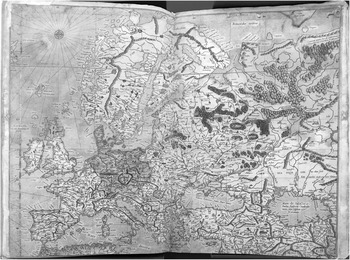
If modern expectations of an “atlas” find no materialization in the codex, there is evidence of various kinds – none conclusive, some merely suggestive – to suggest that it traveled with the Crown Prince. Merely suggestive is the pervasive water damage to the codex (see fig. 2). While Ortman’s later additions also show water damage, Pighius’s account documents travel on ships and periods of rain, rivers overflowing their banks, flooding so serious that it delayed travel (Diedenhofen Reference Diedenhofen2008).
Europa, showing water damage. © British Library Board, Maps C.29.c.13.

There is also Mercator’s consistent effort, manifest in those dedications, to place his cartographic discoveries and vision before the eyes of rulers, foremost his own patron, the Crown Prince’s father. The codex contains 9 maps cut from Mercator’s wall map of Europe, which, according to the British Library website, “helped establish Mercator’s reputation.” It is plausible that he sought to place his work among the objects that traveled with the Crown Prince, that might be shown in every court the Crown Prince visited, as one of the Duke’s own “wonders.” The codex contained examples of his cartographic genius, the two wall maps of Europe and of the world, as well as, among the maps Ortelius had collected in the Theatrum, a different sort of testimony, Ortelius’s scaled down version of Mercator’s map of Flanders.
But the strongest evidence lies in the emphasis throughout the entire journey on the education of the Crown Prince’s eyes, to shape mind through sight (Lindberg Reference Lindberg1976; Early Modern Eyes Reference Melion and Palmer Wandel2010). And here, the newness, the sheer innovation of the British Library codex becomes a kind of evidence for its purpose. The codex was not conventional, its materialization of specific practices of spatial imagination, not familiar. Quite the contrary. It was new. As Ortelius had written to the Reader of his Theatrum, maps usually were hung on walls, folded, unwieldy, difficult to place together.Footnote 4 In his biography of Mercator that accompanied the 1595 Atlas, Walter Ghim wrote, Mercator had conceived of publishing “other and general maps long before Abraham Ortelius, and had resolved to set out the situation of the whole world in a smaller format, and had described with his pen a number of examples, measuring the distance between places in correct proportion, so that nothing remained to be done but to engrave them in brass.”Footnote 5 As Ortelius had done, and as Mercator was to do later, the British Library codex collected in the ancient form a specific kind of “image” which was itself undergoing a dramatic change in its claims for the relationship between lines on a piece of paper and, on the one hand, the somatic experience of the surface of the earth and, on the other, a way of conceptualizing the earth. The codex was educational not in being a kind of “textbook,” but in seeking to teach the Crown Prince to see the earth in new ways.
For this purpose, the codex is eloquent. Let me begin with the form itself (Suarez Reference Suarez2010). Prior to 1570, Mercator had published only one folio-sized map, his very first map, in 1537, an engraving of what he called Palestine – the area the Bible made important to European Christians that was currently under Ottoman rule (Averdunck Reference Averdunck and Müller-Reinhard1914, 15). The two-dimensional maps he produced before then were otherwise wall maps: in 1538, a cordiform map of the world; in 1540, of Flanders; in 1554, the map of Europe that would be cut and pasted in the British Library codex; in 1564, the British Isles; and in 1569, the map of the world that changed cartography (Averdunck and Müller-Reinhard Reference Averdunck and Müller-Reinhard1914, 15-73). These representations took up different spatializations: the area covered by Old Testament narrative; the county of Mercator’s birth and early years of cartography, produced for merchants in Antwerp; the sub-continent; the British Isles, as he wrote at the request of a friend; and the world.
The codex set a relationship between viewer and object that differed from that of a wall map. A folio-sized map was smaller, less susceptible to damage, “to hand.” It also altered the relationship between viewer and object. A folio-sized map might represent a small region or a continent or a hemisphere or the world. Each relationship between person and object altered with scale: between person and domain, person and region, person and continent.
The codex form allowed the binding together of many different kinds of maps: manuscript and printed, cut-and-pasted and single sheet, formerly wall and those originally bound in another codex. The codex form made possible a kind of collection, here not simply, as Ortelius advertised, of multiple maps, but of cartographic production itself. The British Library codex is, among other things, a haptic and visual education in the different methods of making and designing cartographic images, and through them, different ways of conceptualizing the surface of the earth.
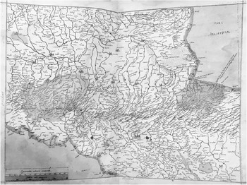
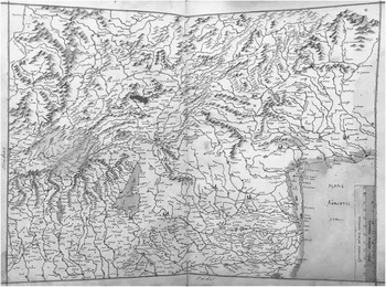
The two manuscript maps, hand labeled on their versos, “Lombardiae regionis Delineatio” [Fig. 3] and “Tirolis & pars Lombardiae” [Fig. 6] manifest one stage early in the production of cartographic images. The Crown Prince may well have known of Mercator’s development of a calligraphy which is legible at different scales – here not only visible, but that by which these two maps were identified (Mercator Reference Mercator1540; Osley Reference Osley1969; Varekamp Reference Varekamp1970, 197). Those maps and the others that Mercator designed all manifest the genius of the design – its consistent legibility – and, insofar as the viewer knows the calligraphy, that calligraphy points toward the cartographic practice of naming and the cartographic perspective of place-names as a formal component of map-making.
Map of Lombardiae. © British Library Board, Maps C.29.c.13.

The edges and seams of the seventeen that had been cut and pasted from wall maps are a visual and particularly haptic education in another method of sixteenth-century cartographic production. One can trace with one’s fingers as well as see where folio-sized maps have been cut from larger wall maps. Those seams and edges are the material traces of a specific cartographic process, which, in turn, point towards a relationship between the map in the hand and a larger image of a larger region. The smaller map has not yet been turned into its own discrete image – redrawn and reprinted in its current selection and shape – but carries on its surface the physical signs of its connection to an image no longer present. The cut edges invoke a larger whole the viewer is invited to imagine from those very edges. The seams and edges are evidence of the cartographic process of cutting paper and reassembling it; at the same time, they point toward the way of conceptualizing the surface of the earth that undergirds that process.
All but two of the maps were printed, an increasingly popular method of map production in precisely the years when the codex was first compiled (Woodward Reference Woodward1996; Carlton Reference Carlton2015). Here, too, the codex offers both haptic and visual educations. One can see and touch the different papers that Ortelius and Mercator bought for the printing of their maps – their texture, their weight, and the signs of their own manufacture. One can also trace the craft that rendered various kinds of topographic information into an image: the design, the woodcutting or engraving, the intaglio or relief process (Woodward Reference Woodward and David2007). The maps composed from wall maps point towards one method of production of printed maps: plates that were designed to connect one edge to the next, that set the printing process. The maps designed to fit a folio page offer another method of production, in which the single sheet of paper formed as well the frame for the section of the earth that had been selected – the frame within which the image was governed by its often visually indicated internal scale.
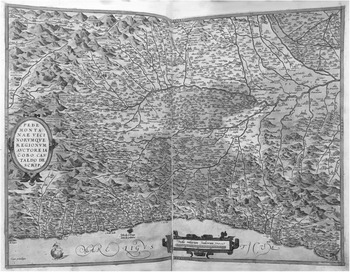
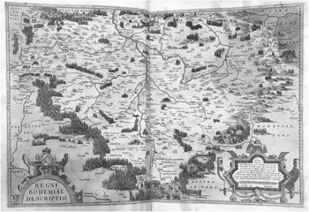
Mercator’s wall maps, from which seventeen maps had been cut, were printed. So, too, were the thirty maps cut from Ortelius’s Theatrum Orbis Terrarum. These, again, offered examples of another method of map-making: the explicit copying of maps drawn by other cartographers (Averdunck Reference Averdunck and Müller-Reinhard1914, 73). Ortelius had provided at the very beginning of his volume the list of the cartographers whose work he had copied for the Theatrum; this was, for him, one value of his volume (Meurer Reference Meurer1991). While we do not know the principle of selection for the Ortelius maps for the British Library codex, those that survived in the codex offer examples of more than thirty different cartographers. Among them are many, such as Giacomo Gastaldi (Piedmont) (fig. 4), whose cartographic representations of specific regions provided the template for later additions, corrections, and improvements, thus also pointing towards the processural nature of cartography, its ongoing processes of emendation, erasure and alteration, accumulation. A number of those maps included in the British Library codex, such as Aegidius Tschudi’s Switzerland, Johannes Criginger’s Saxony and the Kingdom of Bohemia (fig. 5), and Wolfgang Lazius’s Duchy of Austria and Hungary, we know to have been sources for Mercator’s later maps of the same regions.
Map of Piedmont. © British Library Board, Maps C.29.c.13.

Map of Bohemia. © British Library Board, Maps C.29.c.13.

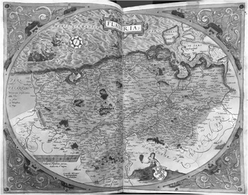
The maps from the Theatrum offer a selection of examples of the cartographer’s art: the discrete decisions as to frame, orientation, selection, sign, and scale. Ortelius did not seek to have all the maps he collected redesigned to conform to any standard of uniformity, either aesthetic or mathematical. The maps from the Theatrum offer examples of different kinds of framing, from Mercator’s elaborate cartouche which makes of the map of Flanders an oval, to those enclosed in what is drawn to look like the wooden frame of a picture hanging on the wall (Gelderland and Cleves), to those, such as the map of Friesland, with a single line as their frame. Many but by no means all orient the map with north at the top of the page, a principle of orientation Mercator was to make express in his own codices of maps.Footnote 6 Some, such as the maps of Portugal and Narbonne, are oriented with west at the top of the sheet of paper; some, such as the map of the Kingdom of Naples, with east at the top edge; Tschudi’s map of Switzerland is oriented with south at the top. In not sharing the same scale, but being printed on the same size paper throughout, the maps also offer a variety of principles of selection: the portion of the surface of the earth that is rendered on each page may be determined by different levels of political jurisdiction – kingdoms, duchies, counties, dioceses – or an economic region, such as the Piedmont, or a geologic feature, such as islands.
Together the maps offer an education in another critical cartographic practice: signs (Delano-Smith Reference Delano-Smith2007). The viewer can see on individual maps those visual marks by which cartographers signal specific kinds of topographic information: forests; mountains; settlements; water – rivers, lakes, seas, marshes. None provides a legend for the cartographic signs on their surfaces. Viewed together, the maps suggest both the broad conventions and the variations for signaling information cartographers held to be critical. Some maps represent forests, marked with a form recognizable as a tree, usually a deciduous tree; the trees vary in scale and number in designating places where a traveler would have encountered dense growth – and quite possibly greater danger from predators human and animal. On maps in which the selection of area encompasses mountain ranges, mountains are marked with humps or more angular forms, sometimes colored brown or, on the map of Tirol, green; like the trees marking forests, those mounds may be numerous or few, large or small—again, for travelers, the key information of the sign was not its form, or even accuracy of elevation, but its absence, which signaled valleys, routes more easily traversed.
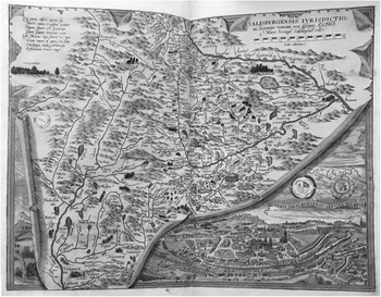
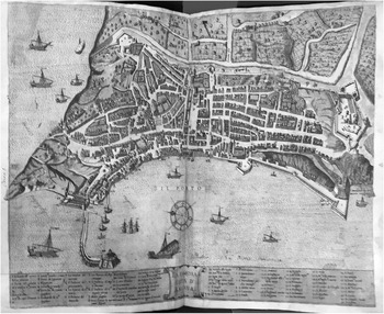
Settlements were also marked variously, calling attention to the practice of marking signs in yet a different way. Some, those cut from the wall map of Europe, presented all towns with circles colored red. Some, such as the map of Slovenia and southeastern Europe, represented all settlements as fortified towns. Most of the maps offered a mixture of circles, sometimes colored red, and clusters of towers, also often colored red, to indicate smaller and larger towns respectively. Many of the maps differentiated among the signs for towns, with clusters of one, two, or more towers. None of the signs, as the travelers might discover in specific places, corresponded to that town’s chorography, for which the British Library codex provided two examples: Marcus Secznagel’s map of the archdiocese of Salzburg with its chorography of the city of Salzburg in the lower right corner; and the chorography of Ancona (figs. 8 and 9). The relation among topographic information, sign, and travel differed from the signs for mountains and forests: the signs for settlements were points toward which travelers might direct themselves, even as the sign did not provide information as to how that particular town would look on approach, again, underlined by the existence of the two chorographies that represented other visual information.
Cartographers used a range of techniques to designate and differentiate water: rivers major and minor, lakes, seas, oceans, and marshes. Some maps represent rivers as a line; more, as multiple lines which do not quite run parallel to one another. Most maps mark bodies of water – lakes, seas, oceans – with multiple lines, suggesting not a clear boundary between land and water, but a gradation. In many of the maps, water has been colored blue. Some also designate marshes, with the form of grasses or a distinctive patterning. A number of maps also contain coasts: all the maps of islands (British and Mediterranean), Europe, those of the Iberian Peninsula, of France and its coastal provinces, the Low Countries, Italy, Germany, Greece, southeastern Europe, Holstein, Prussia, Scandinavia, and Asia Minor. In these, too, the marking designates not a clear and fixed border, but a gradation between land and water.
Coasts are marked as one kind of zone, a transition from land to water (Cosgrove Reference Cosgrove1999, 7). Some of the maps contain signs for political boundaries: dashed lines, dots, in some cases unbroken lines. Each of these signs “represented” in the visual language of cartography. If trees and mounds indicated roughly where a traveler might encounter forests and mountains, circles or clusters of towers and walls, where a traveler might find a town or city, these signs might have no physical correlation whatsoever. A traveler thus encountered with the signs for political boundaries a different cognitive relation between sign and topography – quite possibly no physical correspondence at all. These signs indicated lines not inscribed on the land itself, but set forth in legal documents, descriptively.
8. Practices of Spatial Imagination and Travel
If the collection of maps offered an education in cartographic practices in general, some maps represent regions that the Crown Prince and his retinue physically traversed. While none depicts specifically a segment of the itinerary, they do offer ways of imaging the space the entourage was traversing. They invite their viewer to a consideration of cartographic practices in relationship to the physical experience of space (Cosgrove Reference Cosgrove1999; Cosgrove Reference Cosgrove2001, Cosgrove Reference Cosgrove2008). They thus offer a deeper education in the ways maps are the medium as well as the materialization of ways of conceptualizing both the surface of the earth and the relationship of person to that surface.
The manuscript maps, for instance, offer images of exceptional topographic detail of certain kinds for the regions in northern Italy where the entourage stopped more frequently (figs. 3 and 6). One can locate on the map of Tirol Bolzano, Trent, Bassano, Venice, Padua, Vicenza, Verona, and Brescia; on the map of Lombardy Parma, Modena, Bologna, Ferrara, Ravenna, and Rimini; on both, Mantua. As with so many of Mercator’s maps, these provide exceptional detail on rivers; as with so many of his maps, they are less detailed on mountains, but the valleys – where the entourage traveled – are legible. Both offer ways of envisioning the land the entourage was traversing, as at once an integral whole framed by those red lines marking the borders of the image and, again those red borders, a segment of a larger terrain, be it Italy, Europe, or the world. These two in particular call attention, by those red borders, to the cartographer’s act of selection, a decision to represent what is a segment. And in the uniformity of signs within those borders, they also suggest a way of viewing the surface of the earth as inscribed with rivers, settlements, mountains, and forests; political boundaries, on these maps, were not marked, were not physically present on the surface of the map, were not a part of the description of the earth.
Map of Tirolis. © British Library Board, Maps C.29.c.13.

The maps of Flanders and Salzburg call playful and dramatic attention to the act of framing – the cartographer’s decision, which segment, which information – and, by implication, the concept of “borders” (figs. 7 and 8). The scrolling and cartouches around the edges of representations of named places, Flanders and the archdiocese of Salzburg, make express that the selection of any segment is an act of artifice, an incision of a square on a sphere. Not only is the representation an artifice, but the selection of segment, information, and emphasis are all express choices the cartographer has made. “Borders” in these maps are crafted, made with human hands, inscribed through the devices of visual artifice.
Map of Flandria. © British Library Board, Maps C.29.c.13.

Map of Salzburg. © British Library Board, Maps C.29.c.13.

Eleven maps cut from Ortelius’s Theatrum represent regions that the Crown Prince and his entourage traversed. The names of the “authors” of those maps that have been attributed, but on which the author’s name does not appear, are given in parentheses.
Gelders and Cleves by Christian Sgrooten
The Kingdom of Naples by Pietro Ligorio
Rome (Eufrosino della Volpaia)
Friuli (Gregorio Amaseo)
Piedmont by Giacomo Gastaldi
Bavaria by Johannes Aventinus
The Bavarian Palatinate by Erhard Reich
Salzburg by Marcus Secznagel
The Duchy of Austria by Wolfgang Lazius
The Kingdom of Bohemia (Johannes Criginger)
Hungary by Wolfgang Lazius
Since Carl Frederick died in Rome, we do not know if other maps were intended to provide representation of topography they were traveling: Tuscany by Girolamo Bellarmati; Lake Como by Paolo Giovio; the Duchy of Württemberg; or Transylvania by Johannes Sambucus.
Ancona also belonged to the itinerary Pighius planned for the Crown Prince (fig. 9). The chorography of the city in the British Library codex is undated, bearing only the initials A.B. to indicate its author (Mercator’s Atlas of Europe 1996, 29; Barber Reference Barber2013, 17). If the codex served complex educational purposes, then a chorography of a famous port might have been included in the original compilation or added during the trip. It offers, again, a different example of cartography, here a different perspective entirely of settlement and a way of “viewing” the city (Frangenberg Reference Frangenberg1994), which was, as a traveler would discover, a fiction: a bird’s eye view from above the water.
Map of Ancona. © British Library Board, Maps C.29.c.13.

9. Practices of Spatial Imagination and Imagining Politics
Most of the maps from the Theatrum correspond to domains: the kingdoms of Portugal, Naples, Bohemia, and Hungary; the Duchies of Narbonne, Savoy, Burgundy, Cleves, Tuscany, Bavaria, Württemberg, Saxony, Austria, and Prussia; the Counties of Flanders, Gelderland; the Archdioceses of Münster, Osnabruck, and Salzburg; the Swiss cantons; the Papal States. Other of the maps from the Theatrum, such as those of Friesland and Franconia, present spaces of complex political histories that would be, for the nephew of the Holy Roman Emperor and cousin of the King of Castile and Aragon, important to envision, to conceptualize spatially as well as legally and personally. Set in dialogue with the physical experience of travel, these maps offered yet another layer of education: even as rule in sixteenth-century Europe remained personal, these maps represented spaces with marked boundaries of jurisdiction (Olwig Reference Olwig2002). They were not instruments of government, but materialized another way of conceptualizing politics – spatially and topographically, as terrain with rivers, settlements, mountains, forests. Vienna was not simply the favored residence of his uncle, but located: on the major river of eastern Europe, which flowed towards the Ottoman Empire and the Black Sea. The court of his relative in Mantua was situated – on both manuscript maps – on a tributary of the Po River.
Hispania. © British Library Board, Maps C.29.c.13.

Bound with the maps of domains cut from the Theatrum, the cutting and pasting of the maps of the Iberian Peninsula, France, Scotland, and “Germania” invites yet another reading: the making of political spaces. Cutting and pasting materializes a way of imagining a domain spatially. In the case of “Hispania,” the viewer can see the seams, the edges, even as the drawn terrain is unmarked by dotted, dashed or solid line (fig. 10). Here calligraphy alone distinguishes between regions, such as Castile, Leon, and Navarre, each labeled with a capitalized lower-case word, and the political entity, “HISPANIA.” This map retains the original cartographic signs for mountains, rivers, settlements, as well as the original labeling, but it adds, in making visible its very composition, another way of imagining that political space as itself constituted by severing and attaching, of pieces cut from the land and formed into a spatial entity by human hands.
10. Human Scale and Divine Mathematics
The map of Hispania materializes multiple ways of imagining space (Woodward, Delano-Smith, Yee Reference Woodward, Delano-Smith and Yee2001; Cosgrove Reference Cosgrove1999, Reference Cosgrove2001, Reference Cosgrove2008). Presenting the Iberian Peninsula as a geographic and implicitly political whole, it also carries traces of lines of longitude and latitude, printed on the original wall map, and has been inscribed, in Mercator’s hand, with scales, here two different scales, of German and Spanish miles (Barber Reference Barber2013, 13). Each of the maps cut from the 1554 wall map of Europe – Hispania, France, Italy, Germania, Greece, Sweden and Norway, Lithuania and Russia, and Asia Minor – retains traces of printed lines of longitude and latitude. Each has also been inscribed with scales: one, German miles, on Germania, Scandinavia, and Lithuania and Russia; two, German miles and Italian miles, on Italy, Greece, and Asia Minor; two, Spanish miles and German miles, on Hispania; and two, German and Gallic, on France. The two kinds of marking set each of these maps in two scales, the one local and human – German, Spanish, Gallic, Italian miles, each of which, as the viewer sees immediately, was of different length, a different unit of measurement, a unit of measurement set locally and used approximately. The other, as Mercator would make explicit in “De fabrica mundi,” published with his Atlas in 1595, divine.
The maps cut from Mercator’s 1564 wall map of the British Isles differ significantly from those cut from the map of Europe. A single local scale, English miles, without reference to German miles, was inscribed on Ireland, England, Cornwall and Wales, Scotland. No scale was inscribed on the maps of the Hebrides and Orkneys. None of these maps were printed with lines of longitude and latitude traversing the entire plane of the map – their original wall map was not printed with Ptolemaic projection. They bear the same evidence of manual labor – the edges, the seams, the hand drawn red borders and, on all but one, the scales. In this way, they belong to one aspect of that educational enterprise. But they offer a different sort of representation, not only are they not included within the matrices that traverse the maps of Europe and the world – no lines of longitude or latitude – but also they are not inscribed with any referent of scale, no miles as known outside of the British Isles, that would connect them to a larger geographic or cartographic whole.
The British Library codex contains three more maps composed from Mercator wall maps: the maps of Europe and of Greenland, each of which was composed from copies of Mercator’s world map of 1569; and the map of the British Isles that was composed from Mercator’s 1554 map of Europe. All three carry printed lines of longitude and latitude; thus, the British Isles, seen as a geographic whole in the one map, are placed within the system Mercator set forth in his 1569 world map. That map, of the British Isles as a whole, has inscribed, close to its red border, a scale of German miles; that map is situated both within the global system of longitude and latitude and the continental scale of measurement common to all the maps cut from the map of Europe.
The coexistence on so many maps of two systems of spatial measurement – the one local, miles whether Italian, English, Gallic or German, and the other global – invites a simultaneous imagining of place as local and global. Each place on these maps is local not simply in scale, but in the human measurement of the surface of the earth. Those measurements are specific to each place and differ from place to place. At the very same time, each place has a location within a whole, in so many maps, inscribed over the surface of the earth both land and water. That whole is, as Mercator had written on his 1569 world map, mathematically inscribed, subsuming all the systems of local measurement in an entirely different concept of space – as measured celestially, as Mercator wrote.
Those lines of longitude and latitude, so damaged in the production of folio-sized maps, invoke again and again, as do the markings on the margins of some of the maps from the Theatrum, a way of imagining the earth in which the whole determines location, in which each place exists in relationship to all other places, in a relationship articulated in mathematical terms. Those lines are laid over the topography; they cross over domains. Resting on top of the land mass of Europe, they enclose it in a larger grid, a universal system of which Europe was a part, in which Europe had a place which could be graphed. Those lines, transcribed onto maps – of the Iberian Peninsula, the British Isles, France, Germany, Italy, and southeastern Europe – linked each region to others along their lines of latitude and located each region in relation to another along lines of longitude. That image of the world as universal is subtly reinforced by so many visual cues: the consistency of cartographic signs, the consistency of rivers and mountains, the multifarious settlements in every domain in Europe. The differences collected in the British Library codex – of cartographic style, of selection, of orientation, of signs – become in the very collecting examples of human artifice and ingenuity. The lines, marking longitude and latitude, as the viewer might have already been taught to read them, signaled something else entirely – not human ingenuity, but divine mathematics.
11. Conclusion
Placing the British Library codex in an historically specific dialectic opens it to rich imaginings, in Cosgrove’s sense, even as it solves some of the codex’s mysteries. Placing the codex before the eyes of the Crown Prince of the Duchy of Jülich-Cleves-Berg, on his trip to Italy, construing it within the knowledge culture of his court’s cosmographer, Mercator, enables us to see both how this particular codex teaches and what it might teach to those particular eyes and mind: to see on a piece of paper small signs pointing towards somatic experience of natural phenomena beyond human proportion; to conceive of domain as spatial as well as personal; to conceive all domains, including those of his uncle and cousin, as inscribed by human hands and situated within divine geometry. Long before princes were taught to see maps as instruments of power, the codex was inviting an heir to an imperial duchy to imagine political power spatially and in so doing, to reimagine the relationship between power and representation.
Author ORCIDs
Lee Palmer Wandel, 0000-0003-1529-1608
Lee Palmer Wandel is WARF Michael Baxandall and Linda and Stanley Sher Professor of History at the University of Wisconsin. She is the author of Always Among Us: Images of the Poor in Zwingli’s Zurich (1990); Voracious Idols and Violent Hands: Iconoclasm in Reformation Zurich, Strasbourg, and Basel (1995); The Eucharist in the Reformation: Incarnation and Liturgy (2006), all with Cambridge University Press; as well as Reading Catechisms, Teaching Religion (2015) with Brill. She has also edited a number of volumes. Her current research pursues two lines of inquiry: the matter of the liturgy; and Creation in Mercator’s maps.