Introduction
Although Heard Island has been known and periodically visited since the mid-nineteenth century, information on its terrestrial flora is still being gathered. Occupied by sealers from 1855 to 1882 and again during the 1920s, and by the Australian National Antarctic Research Expedition (ANARE) station from 1947 to 1955, this World Heritage island has been visited intermittently by scientific expeditions (Australian Antarctic Division 1995; Downes Reference Downes1998; McGowan Reference McGowan2000; Hughes and Lazer Reference Hughes and Lazer2000). Scientific visits within the last 20 years have added several species to the list of vascular plants, bryophytes and diatoms known from Heard Island (Bergstrom and Seppelt Reference Bergstrom and Seppelt1988; Scott Reference Scott1989; Van der Vijver and others Reference Van de Vijver, Beyens, Vincke and Gremmen2004; Váňa and Gremmen Reference Váňa and Gremmen2005; Turner and others 2005).
At 53°06′S; 73°32′E, Heard Island is some 1650 km north of Antarctica, 4350 km southeast of South Africa, 520 km southeast of Îles Kerguelen and 5340 km southwest of Western Australia. South of the polar front in the vast southern ocean, Heard Island experiences the severe weather typical of the region: mean sea level temperatures of 5.2°C (maximum), −0.8°C (minimum), mean windspeed of 9.1 ms−1, mean rainfall approximately 1381 mm, snowfalls throughout the year but principally in winter and spring (Thost and Allison Reference Thost, Allison, Green and Woehler2006).
Heard Island is dominated by the 20 km diameter strato-volcano complex, Big Ben, the summit of which, Mawson Peak, is 2745 m above sea level. Smaller strato-volcanoes form Laurens Peninsula in the northwest, volcanic remnants form Azorella Peninsula in the north, and there are a number of parasitic scoria cones around the slopes of Big Ben and Laurens Peninsula. Twelve major and several minor glaciers clothe the slopes of the Heard Island volcanoes, and there is extensive permanent ice and snow (Kiernan and McConnell Reference Kiernan and McConnell1999). The elongate spit at the eastern end of the island has been formed by oceanographic distribution of volcanic debris and material deposited by the melting of glaciers (Quilty Reference Quilty2007).
It is clear that the terrestrial environments of Heard Island are changing quite rapidly, associated with climate warming and changing atmospheric circulation patterns (Allison and Keage Reference Allison and Keage1986; Budd Reference Budd2000; Thost and Allison Reference Thost, Allison, Green and Woehler2006). The mean temperature at Atlas Cove for 1948–1954 was 1.3°C, and for 1997–2000 was 2.1°C. Modelling indicates an overall warming of 1.0°C during the 50 year period from 1949, or 2.03°C per 100 years (Thost and Allison Reference Thost, Allison, Green and Woehler2006). Glacier snouts are retreating, moraine ice-cores are disintegrating, proglacial lakes are expanding. Since the late 1940s, 9.8% of the island has been deglaciated (Ruddell Reference Ruddell, Green and Woehler2006). The northern margin of the Stephenson Glacier retreated at ∼100 m per year, and melt-lakes around its margin increased at ∼11.3 ha per year between 1987 and 2000 (Kiernan and McConnell Reference Kiernan and McConnell2002).
At present less than 40 km2, or about 10% of the island's 368 km2, is ice-free (Kiernan and McConnell Reference Kiernan and McConnell1999) and hence available for establishment of vegetation. Vegetation composition and patterns have been described recently (Hughes Reference Hughes1987; Whinam Reference Whinam1989; Bergstrom and Selkirk Reference Bergstrom and Selkirk1997, Reference Bergstrom and Selkirk2000; Bergstrom and others Reference Bergstrom, Whinam and Belbin2002; Scott and Bergstrom Reference Scott, Bergstrom, Green and Woehler2006), including a study of changes in vegetation associated with glacial retreat (Scott Reference Scott, Kerry and Hempel1990). A project is currently underway to map the vegetation of Heard Island using a combination of satellite imagery, aerial photographs and field knowledge (Scott and Brolsma Reference Scott and Brolsma2004).
This study provides new information on the distribution of moss species on Heard Island. It does not encompass taxonomic re-evaluation of species recorded or previously recorded from the island, a process underway by others (Green and Woehler Reference Green and Woehler2006: Appendix 2). It extends the study of Bergstrom and Selkirk (Reference Bergstrom and Selkirk1997), contributing to knowledge of the present vegetation and flora that survives on this island of volcanoes and retreating glaciers, so that future changes in vegetation patterns may be more easily monitored.
Methods
Field collections
During a three week visit to Heard Island in October and November 2000 as part of the Australian Antarctic Programme, collections were made at 24 sites around the island. Helicopter support allowed access to a variety of locations including several sites isolated by glaciers and not accessible on foot. However, because of constraints of weather and helicopter availability, the time available at many sites was short and resulted in greatly varying times for searching and collecting. Our visit to Heard Island preceded the spring thaw and at many sites vegetation was snow covered, so that collections of bryophytes could be made only after digging through snow and ice. Collections were, as a result, somewhat random and far from complete at some locations, although nevertheless valuable since there have been few previous collections of bryophytes from Heard Island, and none at all from some of the sites that were visited.
Specimens were placed into plastic bags in the field, stored at ambient temperature (below 0°C) on Heard Island, and subsequently air dried and stored in paper envelopes. They have been identified at Macquarie University, and voucher specimens have been lodged with the National Herbarium of New South Wales at the Royal Botanic Gardens, Sydney (NSW). Specimens collected by D. Bergstrom on a previous expedition in 1987 have not been re-examined, but comparisons have been made with published data (Bergstrom and Seppelt Reference Bergstrom and Seppelt1988; Bergstrom and Selkirk 1997) in order to provide additional information on species distribution.
Descriptions of collection sites
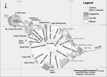
Geomorphological information is from Kiernan and McConnell (Reference Kiernan and McConnell1999), and coordinates are from the Australian Antarctic Gazeteer (Australian Antarctic Data Centre 2006). Sites are listed clockwise around the island starting from Atlas Cove (Fig. 1).
Map of Heard Island showing collection sites.

Atlas Cove and Atlas Cove camp
The eastern shore of Atlas Cove (53°01′23′′S; 73°23′10′′E) at the southwestern corner of Azorella Peninsula has been the regular campsite of expeditions to the western end of Heard Island since 1947. This was the site of the temporary hut and tent camp for the 2000–2001 ANARE during which collections for this study were made. Collections from vegetated areas in the vicinity were designated ‘Atlas Cove’, and collections from timber and iron buildings from former expeditions (Whinam and others Reference Whinam, Selkirk, Downing and Hull2004) that were later demolished (Hull Reference Hull2002), were designated ‘Atlas Cove camp’.
Azorella Peninsula (53°00′48′′S; 73°24′09′′E) is linked by a tombolo to the main part of Heard Island. It has considerably eroded volcanic remnants at its northern margin and its small lava fields include lava tubes. Collections were made in the southwestern quarter.
Baudissin Moraine of Baudissin Glacier (53°02′13′′S; 73°25′53′′E). Collections were made on the western lateral moraines. The moraines are ice-cored with highly mobile large clasts.
Hoseason Beach (53°01′47′′S; 73°26′45′′E) is north-facing, between Baudissin and Challenger Glaciers, and was only accessible by helicopter.
Saddle Point (53°00′42′′S; 73°30′03′′E) is a scoria cone with a small lava field, linked by a tombolo to the north side of Heard Island, seawards of Mary Powell Glacier. Collections were made from the vegetated areas of Saddle Point, including from inside the crater.
Cape Bidlingmaier (53°00′55′′S; 73°32′11′′E) is a north-facing scoria cone and small lava field seawards of Downes Glacier, and was only accessible by helicopter.
Gilchrist Beach (53°01′42′′S; 73°35′34′′E) is northeast-facing, between Ealey Glacier and Compton Lagoon, and was only accessible by helicopter.
Stephenson Lagoon (53°06′06′′S; 73°42′12′′E) is a proglacial lake from the northern side of Stephenson Glacier, constrained by coastal barrier. Collections were made from a lateral moraine ridge and from beside the small water body between Stephenson Lagoon and Scarlet Hill.
Spit Bay camp, 500 m east of Stephenson Lagoon, is the regular site of camps for expeditions to the eastern end of Heard Island, including the site of a hut and tent camp for 2000–2001 ANARE. Collections were made from the vegetated area southwest of the camp.
Winston Lagoon (53°08′54′′S; 73°39′13′′E) is the proglacial lake from Winston Glacier constrained by a coastal barrier. Collections were made from the western side of the lake between Capsize Beach and Winston Glacier.
Long Beach (53°11′19′′S; 73°30′53′′E) is on the south coast of Heard Island. Collections were made from beside Manning Lagoon (frozen and snow-covered at the time), between Manning Lagoon and Long Beach Hut, and on moraines associated with Deacock Glacier.
Cape Arkona (53°09′36′′S; 73°25′51′′E) faces southwest between Gotley and Lied Glaciers, and was only accessible by helicopter. The site was snow-covered at the time collections were made.
Cape Pillar (53°08′19′′S; 73°24′31′′E) faces southwest between Lied and Abbotsmith Glaciers, and was only accessible by helicopter. The site was snow-covered at the time collections were made.
Walsh Bluff (53°06′00′′S; 73°22′48′′E) faces west between Abbotsmith and Allison Glaciers, and was only accessible by helicopter. The site was snow-covered at the time collections were made.
Cape Gazert (53°04′30′′S; 73°22′19′′E) faces west between Allison and Vahsel Glaciers. Collections were made around a small melt lake and amongst lateral moraines of Vahsel Glacier.
Pageos Moraine (53°03′12′′S; 73°23′24′′E) is a latero-terminal moraine of Vahsel Glacier. Collections were made from the crest of the outermost (oldest colonised) moraine.
Mt Aubert de la Rue (53°01′22′′S; 73°22′30′′E) is a heavily eroded scoria cone on the western shore of Atlas Cove.
Gotley Glacier (53°09′00′′S; 73°28′60′′E). Collections were made from the inner edge moraine, probably ice-cored, c. 200m a.s.l.
Laurens Peninsula (53°00′00′′S; 73°18′00′′E), a subsidiary volcanic centre with Mt Olsen, Anzac Peak, and Mt Dixon, flanked by pahoehoe lava flows, is linked by a tombolo to the main part of Heard Island. At the western edge of Laurens Peninsula there are two scoria cones, Macey Cone and Red Island, the latter joined by a tombolo to Laurens Peninsula. Collections were made on lavas on the eastern side of Red Island, to the east of Red Island lagoon, and on lavas around Macey Cone.
Analyses
The species presence/absence data from our collections made in 2000 were combined with data from collections made by D. Bergstrom in 1987 (Bergstrom and Selkirk 1997), and were subjected to exploratory cluster analysis and the Monte Carlo test of significance.
Results and discussion
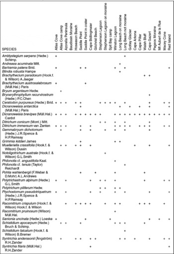
A total of 30 species has been identified from the 583 specimens examined from the 24 locations visited during fieldwork in 2000. Table 1 records the presence of all species collected at all 24 sites visited during fieldwork in 2000.
Presence of moss species on Heard Island at all sites visited in 2000.

Three new species have been added, Bryoerythrophyllum recurvirostrum (Hedw.) P.C.Chen, Philonotis cf. tenuis (Taylor) Reichardt and Syntrichia filaris (Müll.Hall) R.H.Zander, to the list of moss species records for Heard Island. Bryoerythrophyllum recurvirostrum is known from nearby Îles Kerguelen and from Macquarie Island, from the maritime Antarctic South Orkney Islands, South Shetland Islands and Antarctic Peninsula, and also from continental Antarctica, Australia, New Zealand, Europe and North America (Ochyra and Zander Reference Ochyra and Zander2002; Seppelt Reference Seppelt2004). Philonotis tenuis is known from subantarctic Macquarie and Marion Islands, and also from Australia, New Zealand and Tristan da Cunha (Seppelt Reference Seppelt2004; Gilmore Reference Gilmore2006). Syntrichia filaris is known from nearby McDonald Island and Îles Kerguelen, and subantarctic South Georgia, from the maritime Antarctic South Orkney and South Shetland Islands, from the Falkland Islands, and from South America in Patagonia and Tierra del Fuego (Lightowlers Reference Lightowlers1986).
Racomitrium pruinosum was recorded where previously R. lanuginosum had been recorded (Bergstrom and Seppelt Reference Bergstrom and Seppelt1988; Bergstrom and Selkirk 1997). Seppelt (Reference Seppelt2004) reassessed specimens of R. lanuginosum from Macquarie Island as R. pruinosum. Similarly, referring to the study of Vitt and Marsh (Reference Vitt and Marsh1988), samples from Bergstrom's 1987 collections have been examined and it is believed that they include R. pruinosum rather than R. lanuginosum, making this a reassignation rather than a new record.
Lightowlers (Reference Lightowlers1986) notes that specimens of Syntrichia anderssonii from Macquarie Island have abundant sporophytes, but that sporophytes are unknown from other subantarctic localities. One specimen of Syntrichia anderssonii with sporophytes was collected and one with perichaetial leaves and archegonia from Cape Bidlingmaier.
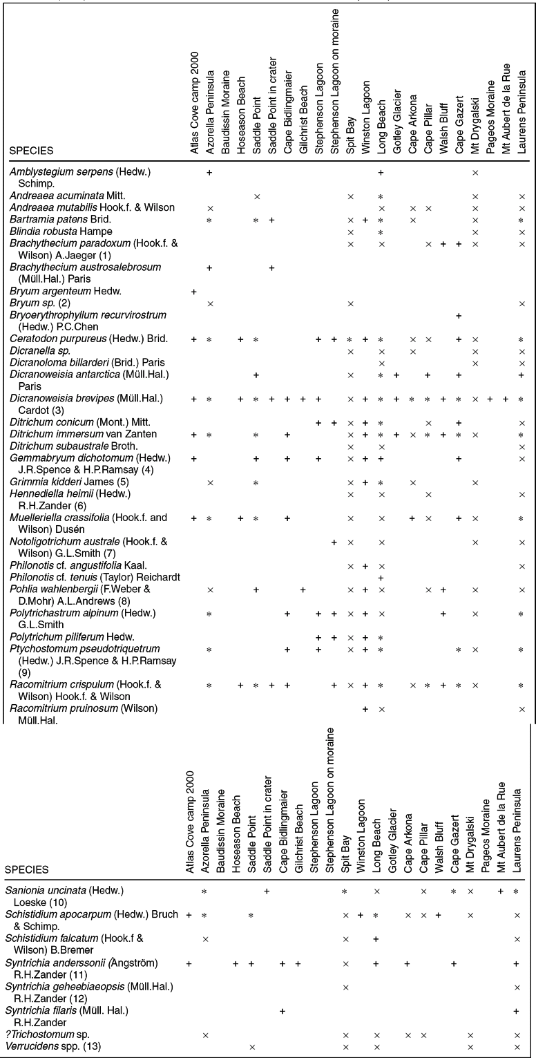
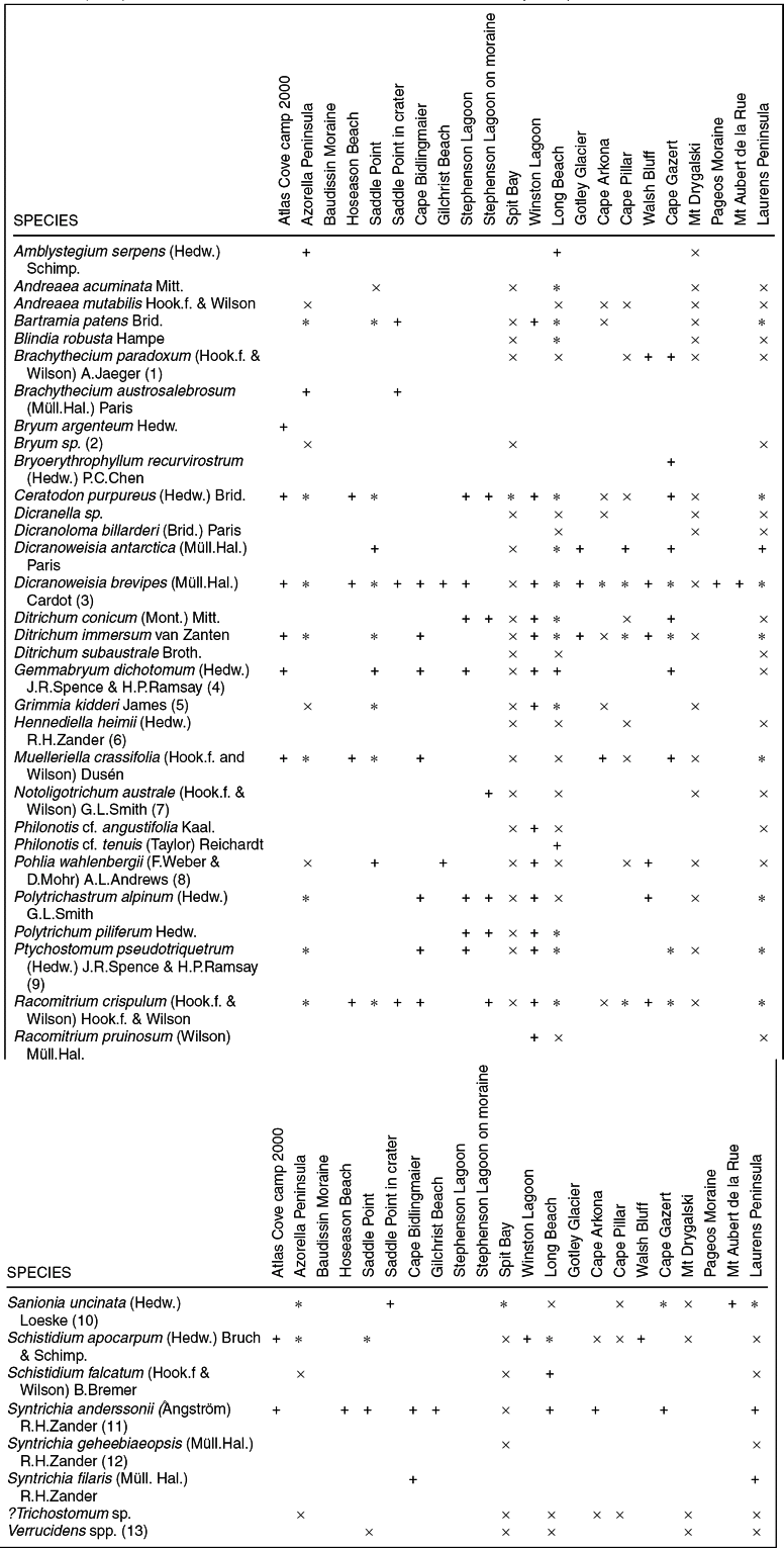
To allow comparisons between the species records from the 1987 and 2000 collections, Table 2 presents data from Bergstrom and Selkirk (1997) alongside data from Table 1, but with some modifications to each. Where 2000 collections were made in comparable locations to those in 1987, locations are listed as in Table 3 of Bergstrom and Selkirk (1997). To achieve this, the Red Island and Macey Cone records in Table 1 are included in Laurens Peninsula in Table 2: Atlas Cove and Azorella Peninsula records in Table 1 are combined as Azorella Peninsula in Table 2. Where collections at a particular location were made in only 1987 or 2000, the record appears for the relevant year only. Table 2 shows the total of 40 taxa collected by the two expeditions.
Presence of moss species on Heard Island at sites visited in 2000 (this study) and 1987 (collections by Bergstrom in 1987, as shown in Table 3 of Bergstrom and Selkirk 1997). Species collected in 2000 have been arranged in locations matching the 1987 collections where collection were made from the same nine locations. At 10 additional locations not visited in 1987 collections are recorded from 2000 only. Moss names that have changed from Bergstrom and Selkirk (1997) are noted and discussed in the text but listed under currently-accepted names.
+ = species collected only in 2000
x = species collected only in 1987
* = species collected in 1987 and 2000.
(1) includes Brachythecium sp. of Bergstrom and Selkirk (1997).
(2) includes Bryum sp. 1 and Bryum sp. 2 of Bergstrom and Selkirk (1997).
(3) includes Dicranoweisia spp. of Bergstrom and Selkirk (1997).
(4) replaces Bryum dichotomum Hedw.
(5) replaces Grimmia immerso-leucophaea (C.Muell.) Kindb.
(6) replaces Pottia heimii (Hedw.) Fuernr.
(7) formerly Psilopilum australe (Hook.f. et Wils.) Mitt.
(8) includes Pohlia wahlenbergii and Pohlia sp. of Bergstrom and Selkirk (1997).
(9) replaces Bryum pseudotriquetrum (Hedw.) P.Gaertn., B.Mey. & Scherb.
(10) replaces Drepanocladus uncinatus (Hedw.) Warnst.
(11) replaces Tortula anderssonii Aongstr. (Zander Reference Zander1993).
(12) replaces Tortula geheebiaeopsis (C.Muell.) Broth.
(13) Verrucidens has been transferred to Dicranoweisia (Ochyra Reference Ochyra1999) but it is not clear to which species these records should be referred.
Recent moss name changes and re-evaluations are noted but species are listed with authorities in Table 2 under currently accepted names. Authorities for species not included in tables are given in the text. Brachythecium paradoxum of Table 2 includes Brachythecium sp. of Bergstrom and Selkirk (1997). Bryum sp. of Table 2 includes Bryum sp.1 and Bryum sp.2 of Bergstrom and Selkirk (1997). Bryum dichotomum Hedw. and Bryum pseudotriquetrum (Hedw.) P.Gaertn., B.Mey. and Scherb. in Bergstrom and Selkirk (1997) have been replaced with Gemmabryum dichotomum and Ptychostomum pseudotriquetrum respectively (Spence and Ramsay Reference Spence and Ramsay2006). Dicranoweisia brevipes of Table 2 includes Dicranoweisia spp., a species complex of D. brevipes and D. breviseta of Bergstrom and Selkirk (1997). Bergstrom and Seppelt (Reference Bergstrom and Seppelt1988) considered D. brevipes and D. breviseta only doubtfully distinct. Grimmia immerso-leucophaea (C.Muell.) Kindb. in Bergstrom and Selkirk (1997) is replaced with Grimmia kidderi (Ochyra and Hertel Reference Ochyra and Hertel1990; Munoz and Pando Reference Munoz and Pando2000). The name Pottia heimii (Hedw.) Fuernr. in Bergstrom and Selkirk (1997) is replaced with Hennediella heimii (Zander Reference Zander1993). Notoligotrichum australe was formerly Psilopilum australe (Hook.f. et Wils.) Mitt. Pohlia wahlenbergii of Table 2 includes Pohlia wahlenbergii and Pohlia sp. of Bergstrom and Selkirk (1997). Drepanocladus uncinatus (Hedw.) Warnst. in Bergstrom and Selkirk (1997) is replaced with Sanionia uncinata. Tortula anderssonii Aongstr. in Bergstrom and Selkirk (1997) is replaced with Syntrichia anderssonii (Zander Reference Zander1993). Tortula geheebiaeopsis (C.Muell.) Broth. in Bergstrom and Selkirk (1997) is replaced with Syntrichia geheebiaeopsis (Zander Reference Zander1993). Verrucidens has been transferred to Dicranoweisia (Ochyra Reference Ochyra1999) but as it is not sure to which species the records should be referred, the name Verrucidens spp. used in Bergstom and Selkirk (1997) has been retained.
Table 2 compares the species recorded in 2000 (+) with those collected in 1987 (x), showing that we have extended the locations from which many species have been recorded, mainly by the availability of helicopter access to previously unvisited locations. Cape Bidlingmaier, Hoseason Beach, Gilchrist Beach, Stephenson Lagoon and nearby moraines, Winston Lagoon, Walsh Bluff, Mt Aubert de la Rue, Pageos Moraine, Gotley Glacier and Baudissin Moraine were not visited in 1987, so the collections from these sites in 2000 provide, for the species collected, extensions of their range on Heard Island. In addition, several species such as Amblystegium serpens, Gemmabryum dichotomum and Syntrichia anderssonii which were collected from very few locations in 1987 have been collected at additional sites, showing them to be much more widespread than previously known. The smaller number of species collected at some sites such as Spit Bay and Mt Drygalski in 2000 compared with 1987 simply reflects the longer collecting time available at those locations in 1987.
The distributions shown in Table 2 provide confirmation of Bergstrom and Selkirk's (1997) conclusions concerning the distribution of some species: Grimmia kidderi has not been recorded from Macey Cone or Red Island on Laurens Peninsula; Racomitrium pruinosum has not been recorded from Spit Bay; Philonotis cf. angustifolium has not been recorded from Azorella Peninsula. However, contrary to Bergstrom and Selkirk's (1997) finding, we have recorded Brachythecium austrosalebrosum from the Atlas Cove end of Azorella Peninsula. It is also noted that Polytrichum piliferum appears to be confined to the eastern end of the island. Table 2 confirms the widespread distribution on the island of Dicranoweisia brevipes, Ditrichum immersum and Racomitrium crispulum (Bergstrom and Selkirk 1997, 2000) and also of Ceratodon purpureus.
A study of the records assembled in Table 2 allows some additional conclusions to be drawn. At several sites few species were recorded. Four such sites, Gilchrist Beach (3 species), Gotley Glacier (3 species), Mt Aubert de la Rue (2 species) and Pageos Moraine (1 species) were each visited only very briefly and only in 2000. The collections probably considerably under-represent the species present at these sites, and the absence of species that apparently characterise them is likely to be a result of the limited opportunity for fieldwork, rather than a reflection of the vegetation at these sites.
At Saddle Point Crater only five moss species were recorded, despite a thorough search of the small but unusual site within the crater. In this case, the very small number of species present seems to be a real characteristic of the site.
The western lateral moraines of the Baudisson Glacier are ice cored with large clasts forming unstable surfaces. Vegetation was found to be sparse with only occasional plants of Pringlea antiscorbutica R.Br.ex Hook.f and Azorella selago Hook.f. Despite an extensive search no bryophytes were found on these unstable surfaces, making a striking contrast to the significant bryophyte cover on stable moraines everywhere from sea level to more than 200 m above sea level (Bergstrom and Selkirk 2000; Table 2 this study). We interpret the absence of mosses on the Baudissin Moraines to be due to their inability to establish successfully on the unstable surface, despite the likely arrival of plentiful moss propagules. This is comparable to the failure of bryophytes to become established on Macquarie Island in areas of feldmark where cryoturbation causes surface instability (Bergstrom and Selkirk 1999).
A group of three sites (Stephenson Lagoon, Stephenson Lagoon on moraine, Winston Lagoon) includes a total of 16 species. The sites are all low altitude, coastal sites at the eastern end of Heard Island. The suite of species distinguishing these sites includes Polytrichum piliferum, known only from the eastern half of the island.
A group of eight small sites (Hoseason Beach, Cape Bidlingmaier, Atlas Cove camp, Saddle Point not crater, Cape Arkona, Cape Gazert, Cape Pillar and Walsh Bluff) has a total of 28 species recorded. Although widespread around the island, all are well-drained sites: rocky land behind a beach, rocky bluffs, old buildings, and moraines. Bryum argenteum was only recorded on old buildings at Atlas Cove camp (Whinam and others 2004), a habitat not replicated anywhere else on the island. Bryoerythrophyllum recurvirostrum was only recorded on old moraine at Cape Gazert.
The remaining five sites (Laurens Peninsula, Spit Bay, Long Beach, Azorella Peninsula and Mt Drygalski) between them include 37 of the 40 species recorded for the island. Philonotis cf. tenuis was only recorded from beside a drainage line at Long Beach. The locations are widespread around the island (Fig. 1), large in area and well-collected by the combination of the 1987 and 2000 expeditions. Although Laurens Peninsula rises to 715 m on Anzac Peak, these five collection sites are below 125 m altitude and encompass a wide range of low-altitude habitats, including habitats with abundant moisture. The vegetation communities described by Bergstrom and others (2002) (six communities) and by Scott and Bergstrom (Reference Scott, Bergstrom, Green and Woehler2006) (seven communities) were all included in the collection sites, consistent with the occurrence of the very high proportion of the island's moss species.
An exploratory cluster analysis of the records in Table 2 confirmed the interpretation that, except for three sites at the eastern end of the island, occurrences of moss species at collecting sites do not group on the basis of geographical location. This is consistent with the conclusions from a larger analysis using vascular plants as well as bryophytes that showed altitude, peat depth, particle size, wind exposure and extent of bare ground to be discriminating variables in determining vegetation composition on Heard Island (Bergstrom and others 2002). Many of the individual ice-free areas on Heard Island are separated from each other by large areas of glacial ice cover, and can indeed be regarded as comparable to an archipelago (Bergstrom and Selkirk 1997). However the very strong, turbulent winds from many and variable directions (Thost and Allison Reference Thost, Allison, Green and Woehler2006), strongly influenced by island topography (Beggs and others Reference Beggs, Selkirk and Kingdom2004), will be very effective in transporting propagules between areas (Van Zanten and Pocs Reference Van Zanten and Pocs1981). These strong winds appear to minimise geographic differences in species composition, provided appropriate habitats exist. The very small number of species in the unusual habitat inside the Saddle Point crater is consistent with the idea that limited habitat variation in some areas has restricted establishment of some species, resulting in lower bryophyte species diversity (Bergstrom and Selkirk 1997).
It seems likely that the suite of mosses present in another unusual habitat on Heard Island, namely the lava tubes on Azorella Peninsula, will similarly prove distinct. No plant collections have been made inside the lava tubes or in their immediate vicinity (Kiernan and McConnell Reference Kiernan and McConnell2000). At the time of our visit in 2000, following the recommendations of Kiernan and McConnell (Reference Kiernan and McConnell2000), Australian Antarctic Division management regulations aimed at preventing damage to the fragile habitat precluded such collections.
In summary, this study has added three species to the known moss flora of Heard Island, Bryoerythrophyllum recurvirostrum, Philonotis cf. tenuis and Syntrichia filaris. Syntrichia anderssonii has been found with sporophytes, whereas previously its sporophytes were only known in the subantarctic from Macquarie Island. Range extensions for several species on Heard Island have been recorded. Most of these new records result from access to sites from which bryophytes had not previously been collected. Despite the changing environmental conditions including ameliorating climate (Thost and Allison Reference Thost, Allison, Green and Woehler2006), it is not possible to say, for sites previously visited, whether any changes in the moss flora indicate the predicted response to environmental change (Selkirk Reference Selkirk and Quilty1992; Bergstrom and Selkirk 1997).
Similar uncertainties apply to the recent additions of Poa annua L. and Leptinella plumosa Hook.f to the vascular flora (Scott Reference Scott1989; Turner and others Reference Turner, Scott and Rozefelds2006). Váňa and Gremmen (2005) consider that their recent addition of seven species to the liverwort flora of Heard Island (including two species new to science) results from increased collecting effort of the still poorly known flora. They feel that it is yet not possible to regard present knowledge as a baseline against which to gauge future changes in biodiversity. Nevertheless, as successive scientific visits to Heard Island contribute their information, knowledge is progressively accumulating concerning the mosses, indeed the flora and vegetation in general, of the harsh but rapidly changing environment of this isolated, wild and beautiful island.
Acknowledgements
We thank the Australian Antarctic Division for logistic support, permission to conduct research and collect specimens on Heard Island, and research funding to AAS Project 2152; the Macquarie University Research Grant Scheme and D.P.I.W.E. for research funding; colleagues of the Australian Antarctic Programme 2000 early summer expedition to Heard Island for support and assistance in the field, particularly A. McConnell, Y. Frenot, T. Peterson, and J. Cane for collection of some specimens and D. Pullinger, R. Piacenza and P. Arthur of the helicopter crew; M. Leishman and D. Storey for assistance with data analyses.