Stratified Great Basin dry cave sites form a fundamental component of the western North American archaeological record. Despite their limited number, the diversity of artifact types excavated from these caves and rockshelters contributes disproportionally to our understanding of the region's prehistory. The dry sediments of these sites provide exceptional preservation conditions resulting in the recovery of organic artifacts rarely found in other archaeological contexts, including textiles, wood tools, clothing, and dietary remains. Strata within these sites often span thousands of years, providing researchers with a temporal framework with which to track changes in prehistoric behavior and ecological conditions throughout the Holocene (e.g., Aikens Reference Aikens1970; Dalley Reference Dalley1976; Jennings Reference Jennings1957; Schmitt and Madsen Reference Schmitt and Madsen2005).
As valuable as these dry caves and rockshelters have been, their utility is only as great as their chronology. At the heart of the interpretation of stratified sites is the process of linking 14C dates from directly dated material with other material excavated from the same stratum. In the past, hundreds or thousands of artifacts were indirectly dated in this process, based on a single or handful of radiocarbon dates (Aikens Reference Aikens1970; Dalley Reference Dalley1976; Madsen and Schmitt Reference Madsen and Schmitt1998), whereas dates numbering in the dozens are common to more recent or revisited excavations (Goebel et al. Reference Goebel, Graf, Hockett, Rhode, Kornfeld, Vasil'ev and Miotti2007; Graf Reference Graf, Graf and Schmitt2007; Rhode et al. Reference Rhode, Madsen and Jones2006). Irregularities between 14C dates within a stratum or within the larger stratigraphic sequence can lead to inconsistent temporal classification of a site's material record. If the disagreement between 14C dates and the stratigraphic sequence is severe, the archaeological value of the entire artifact assemblage may be cast into doubt. Such has been the case for Hogup Cave (42BO36), which has largely existed in archaeological limbo for over four decades since initial 14C dates from the excavation were published (Aikens Reference Aikens1970).
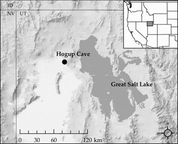
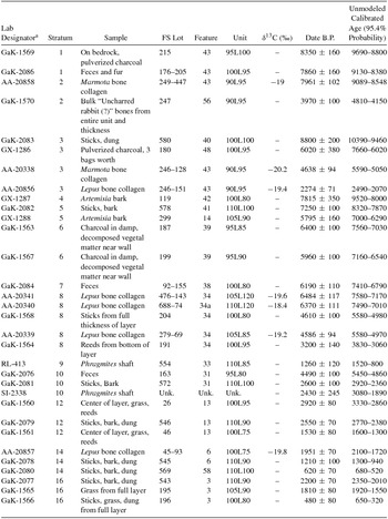
Hogup Cave, located 10 miles west of the Great Salt Lake at the southwest foot of the Hogup Mountains, exemplifies the preservation and cultural depth of Great Basin dry cave sites (Figure 1). Excavations of the site over the summers of 1967 and 1968 yielded thousands of artifacts and faunal remains. These included 491 wooden artifacts, 160 pieces of basketry, 36 textile fragments, 2,811 pieces of cordage, 719 remnants of hide clothing and fragments, 215 pieces of worked bone and antler, 922 ground stone specimens, and 648 projectile points and point fragments (Aikens Reference Aikens1970). It became apparent early in the excavation that the deposition of these materials spanned much of the Holocene. The presence of aquatic bird feathers and freshwater mussels suggests that the cave was occupied at a time when the marshy remnants of Lake Bonneville were still present to the west of the site (Harper and Alder Reference Harper, Alder and Aikens1970). Thick-walled Shoshone pottery, the regional style in use at the time of historic contact, was found in the uppermost strata. Radiocarbon dates ranging from 8350 to 480 radiocarbon years B.P confirmed the cave's trans-Holocene occupation. However, multiple out of sequence dates, sometimes off by as much as 4,000 years from bracketing strata, led to a complex stratigraphic interpretation classifying the site's 16 strata into four temporal units (Aikens Reference Aikens1970). Subsequent dating efforts reported more anomalous dates further complicating interpretation of the cave's stratigraphic sequence (Table 1; Aikens Reference Aikens1976; Berry Reference Berry and Dalley1976; Madsen and Berry Reference Madsen and Berry1975; Mullen Reference Mullen1997).
Location of Hogup Cave, Utah, at base of the Hogup Mountains in the Bonneville Basin.

Previous Hogup Cave Radiocarbon Dates.

a Prefixes GaK and GX (Aikens Reference Aikens1970), SI (Madsen and Berry Reference Madsen and Berry1975), RL (Berry Reference Berry and Dalley1976), and AA (Mullen Reference Mullen1997).
The uncertainty surrounding the cave's dating has hampered research at the site, limiting the potential contribution of Hogup Cave to further our understanding of eastern Great Basin prehistory. With little discussion of the depositional sequence since the 1970s (Aikens Reference Aikens1970, Reference Aikens1976; Madsen and Berry Reference Madsen and Berry1975), researchers have presented conflicting chronological interpretations of the site's 16 strata (e.g., Bayham Reference Bayham1979; Broughton et al. Reference Broughton, Byers, Bryson, Eckerle and Madsen2008; Gunn Reference Gunn1975; Hockett Reference Hockett1994, Reference Hockett2015). This lack of consensus has done little to resolve initial doubts surrounding the integrity and temporal patterning of the site's stratigraphy (Grayson Reference Grayson2011:233; Jones and Beck Reference Jones, Beck, Bousman and Vierra2012:113; Webster Reference Webster1980). The following analysis addresses these concerns.
Background
Excavation Overview and Procedures
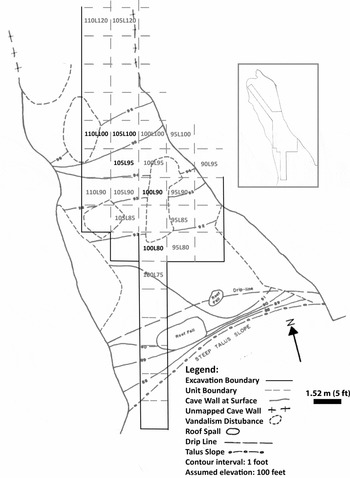
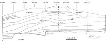
Hogup Cave consists of two chambers, both approximately 16 m long and 9 m wide, with the front, outer chamber's roof approximately 6 m high at the time of excavation and the inner chamber's ceiling somewhat lower. Excavations of the outer chamber began under the direction of C. Melvin Aikens in the summer of 1967, with the crew returning in 1968 to expand the outer chamber's final excavated area to more than 81 m2 (875 ft2) and extend an exploratory trench into the rear chamber (Figure 2, Figure 3).
Excavation grid in front chamber of Hogup Cave. Previously dated units labeled in gray; units dated in this study in black. Modified from Aikens (Reference Aikens1970:Figures 6 and 7).

Profile of the western boundary of excavation (115L line). Profile angles to the northwest north of point B (115L120). Modified from Aikens (Reference Aikens1970:Figure 13).

The site was excavated stratigraphically by following the laminate-like layers present. The composition of strata throughout the 3.4 to 4.3 m deep deposits is rather homogeneous, primarily composed of hair, vegetal matter, faunal material, artifacts, dung, and other anthropogenically deposited material. Differentiation between strata was primarily made not on composition, but on the basis of spatially continuous breaks between successive sedimentary layers. These breaks were hypothesized to be either compacted living surfaces or hiatuses in human occupation, providing chronological markers to indicate stratigraphic boundaries within the cave's sediments (Aikens Reference Aikens1970:14).
Excavation provenance was established by employing the Jennings feature system (Jennings Reference Jennings1957). This method assigns arbitrary numeric designators (“features”) to strata or sediment packages during excavation, collapsing them into larger strata after an excavation is complete and their stratigraphic relationships are better understood. By the end of the 1968 season, over 60 features (not including trenches and the main excavation log, which also receive feature numbers) were consolidated into 16 stratigraphic levels. Horizontal control was maintained through a 1.52 by 1.52 m (5 by 5 ft) grid coordinate system. The system used the first number to express the western disposition, followed by “L”, and then a second number for the northern disposition within an excavation grid using a datum placed at 95L70. Units were named by northeast corner coordinates. Excavated material was screened through 1 / 4 -in mesh, with several column samples subsequently passed through 1 / 8 in and 1 / 16 in. Recovered material was assigned to Field Specimen (FS) lots based on their vertical and horizontal provenance (feature and unit respectively). Excavated sediments that could not be confidently assigned provenance (such as those disturbed by looting prior to excavation or animal krotovinas) were excluded from screening and analysis.
General Depositional Sequence and Horizontal Patterning of Strata
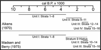
As noted, the excavation identified a total of 16 stratigraphic layers (Figure 3) assigned to four cultural occupation units based on their artifact content and radiocarbon dates (Figure 4). A brief summary of Aikens's hypothesized depositional sequence is outlined below; a detailed discussion can be found in the original excavation manuscript (Aikens Reference Aikens1970:11–26).
Two previously proposed chronological sequences (Aikens Reference Aikens1970; Madsen and Berry Reference Madsen and Berry1975) with radiocarbon ages calibrated in OxCal v. 4.2 (Bronk Ramsey Reference Bronk Ramsey2009a) using the IntCal 13 calibration curve (Reimber et al. Reference Reimer, Bard, Bayliss, Beck, Blackwell, Ramsey, Buck, Cheng, Edwards, Friedrich, Grootes, Guilderson, Haflidason, Hajdas, Hatté, Heaton, Hoffmann, Hogg, Hughen, Kaiser, Kromer, Manning, Niu, Reimer, Richards, Scott, Southon, Staff, Turney and Van DerPlicht2013).

Strata 1 through 7 (excluding Stratum 2) were deposited throughout the outer and inner chambers (Supplemental Figure 1a). After this point, several substantial movements of fill by the site's prehistoric occupants appear to have resulted in the variable presence of Strata 7 through 16. Generally speaking, these movements created three distinct stratigraphic sequences located in the front of the outer chamber, rear of the outer chamber, and the inner chamber.
The first movement of fill was the removal of Stratum 7 from the rear of the outer chamber, starting between grid 100 and 110 north and continuing north into the inner chamber. Stratum 8 was then deposited throughout the entirety of the cave, overlaying Stratum 7 in the front of the outer chamber and Stratum 6 in the remainder of the cave, where Stratum 7 had been removed. Stratum 8 is internally complex and was split into an upper and lower component during the second excavation season (Supplemental Figure 1b).
Strata 9 through 12 were then deposited throughout the entire outer chamber (with the exception of Stratum 11, which is present only in the front portion of the outer chamber; Supplemental Figure 1c). After the deposition of Stratum 12, portions of Strata 9 through 12 appear to have been removed north of grid 110 north, similar to the earlier removal of Stratum 7 (possibly to regain access to the inner chamber). Stratum 13 was subsequently deposited and filled in the space created by the removal of Strata 9 through 12 in the rear portion of the outer chamber and front of the inner chamber, once again blocking access to the inner chamber (Supplemental Figure 1d). With this rear portion of the cave inaccessible, the final deposition of Strata 14 through 16 occurred only in the outer chamber (Supplemental Figure 1e).
In sum, the stratigraphic sequence of the front portion of the outer chamber is relatively straightforward, containing all 16 identified strata (with the exception of Stratum 2, discussed below). The rear of the outer chamber experienced several prehistoric episodes of sediment removal, resulting in the variable absence of Stratum 7 and Strata 9 through 12. While the stratigraphy of the inner chamber was not examined as thoroughly, findings suggest that it was accessible only intermittently and that it contains the depositional sequence of Strata 1 through 6, Stratum 8, and Stratum 13.
The Eastern Periphery
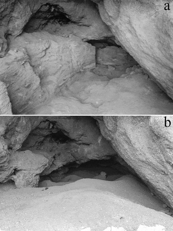
Sediments located adjacent to the east wall of the outer chamber appear to be an exception to the general depositional sequence. The pre-excavation surface dipped sharply down under the low, slanting east wall of the cave (Figure 5a). Artifacts from this area are consistently larger than the more central areas of the site, possibly the result of different depositional processes (Aikens Reference Aikens1970:11; O'Connell Reference O'Connell1987). This peripheral area was recognized to be problematic in the field notes from June 19, 1968: “We have been kept out of potential trouble along the cave walls, where fill is often loose and poorly stratified, and intrusions thus harder to detect” (Hogup Cave Excavation Notes and Photos [Notes], Feature 1, p. 91. Material on file, University of Utah Archaeological Center, Salt Lake City).
(a) Hogup Cave, July 1968. Looking north after completion of the second excavation season; 4.25 m high 115L west profile visible to left. Trench to inner chamber visible to back-left. Disruption by looters from between the 1967 and 1968 excavations visible along right wall to the rear (University of Utah Archaeological Center [UUAC], unpublished excavation photo MA68BW9-12); (b) Hogup Cave, April 2016. Extensive looting has left no trace of the excavation profiles. Note the redistribution of sediments throughout the cave by looters. Access to the inner chamber has been completely blocked and little to no intact sediments appear to be present in the outer chamber.

In the 1967 season, only a small amount of material was excavated from units directly adjacent to the eastern cave wall, most notably 90L95. This was one of only two areas in which Stratum 2 occurred (the other being a small, sterile depression in 105L95 and 105L100). The unit, primarily filled with unmodified small mammal bones, was hypothesized on August 7, 1967, to have been “a trash corner of the cave [deposited] over a considerable period of time” (Notes, Feature 1, p. 40). The lower stratigraphy in this unit is complex, with material from the unit thought to have been part of F43 (Stratum 1), later reassigned to F40 (Stratum 3, discussed below).
Site Vandalism
Located on private land and well-known to locals in the region, the surface sediments of Hogup Cave had experienced a moderate amount of disturbance by looters prior to Aikens's excavation (Figure 2). This activity accelerated significantly after the 1967 excavation season with a large passage (4.5 m long, 1.8 m high, 1.5 to 2.1 m wide) dug by vandals through the base of the sediments along the east wall (Notes, June 11, 1968, Feature 1, p. 85). This disturbance prevented further examination of the depositional differences between the eastern periphery and main area of the site. Fortunately, the working faces of the 105L west profile and most of the 100 north profile were left intact, permitting the 1968 excavation to proceed unaffected except for areas immediately adjacent to the east wall (Figure 5a).
Much more extensive vandalism to the west and north profile walls occurred after the 1968 season. The damage was so extensive that further excavation at the site was rendered impossible, leaving questions regarding the minimally excavated inner chamber and complex transition between the two chambers largely unanswered. Today, continued vandalism and looting at Hogup Cave have destroyed all traces of the original excavation profiles and left little to no intact deposits to examine first-hand through additional excavation (Figure 5b). Fortunately, the detailed excavation log provides a substantial amount of contextual information with which to evaluate previously produced dates and guide the selection of samples dated in this study.
Summary of Previous Dating Efforts
Since 1970, a total of 32 dates on Hogup Cave samples have been produced as part of three separate dating efforts. Sampling method, materials, and radiocarbon methodology differ for all three studies, each introducing potential sources of error discussed below.
Initial Publication
Twenty-three radiometric dates were reported in the original excavation publication (Table 1, GaK and GX series; Aikens Reference Aikens1970:28–29). The majority of dated samples are from the front and central portions of the outer chamber along the central north-south axis of the site. Aikens rejected several of the most out-of-sequence dates (Aikens Reference Aikens1970:12–13), while conceding that some chronological overlap between closely associated strata was the result of minor, undetected stratigraphic mixing (Aikens Reference Aikens1976). Due to radiocarbon dating limitations at the time, all of these dates are on large bulk samples, often from material collected throughout an entire 2.31 m2 (25 ft2) excavation unit within a given stratum.
This sampling strategy introduced two potential sources of errors. The bulk samples submitted for dating are problematic because the more material in such a sample, the greater the chance that material not associated with the targeted event is included (Ashmore Reference Ashmore1999; Bayliss Reference Bayliss2015). It is unknown how many specimens were included in each of Aikens's bulk samples. However, multiple entries quantified as “three bags” or “from entire 5×5 surface” in the FS log indicate that the samples were composed of numerous individual specimens of a variety of material types (Table 1).
The second possible source of error in a subset of these samples is their ambiguous association with human occupation of the site. Samples of charcoal and pronghorn fur are likely to have been deposited by human activity, but much of the other dated material could have been deposited when the cave was not occupied. Significant raptor activity at the site has played a substantial role in the deposition of small mammal remains (Hockett Reference Hockett1994), with nesting activity likely introducing sticks, grass, and other plant materials included in Aikens's samples (note barn owl and nest present in upper left alcove in Figure 5b). Ungulate dung likely deposited during occupational hiatuses (Aikens Reference Aikens1970:14) was also included in several samples.
Dating noncultural material deposited during a break in occupation may erroneously expand the duration of a stratum or lend false support to the continuity of the site's use. This issue is demonstrated by an examination of dates from Stratum 8, which indicate a prima facie depositional period lasting over 4,000 years. We can determine when and to what degree humans contributed to the deposition of Stratum 8 and other strata only with the dating of material from secure archaeological contexts.
Reevaluation of Upper Stratigraphy
In the mid-1970s, two radiometric dates from phragmites shafts (Table 1, RL-413 and SI-2338) were produced in an attempt to establish the timing of the arrival of the bow-and-arrow at the site (Berry Reference Berry and Dalley1976; Madsen and Berry Reference Madsen and Berry1975). Results from RL-413 were used to reclassify Strata 9 through 11 from a Late Archaic occupational unit (Aikens Reference Aikens1970) to a later occupation contemporaneous with the maize farming Fremont (Madsen and Berry Reference Madsen and Berry1975). It was also suggested that a large amount of bat guano within Stratum 9 indicated that a prolonged hiatus occurred between these two occupations (Figure 4). Both of these reclassifications were refuted by Aikens (Reference Aikens1976). SI-2338 appears to be of an appropriate age within the larger stratigraphic sequence but much too early to be a bow-and-arrow component (Berry Reference Berry and Dalley1976; Hildebrandt and King Reference Hildebrandt and King2012).
Paleoecological Research
Five Lepus and two Marmota bones were dated via accelerator mass spectrometry (AMS) as part of a paleoecological project studying the isotope chemistry of small mammals from cave deposits throughout the region (Table 1; Mullen Reference Mullen1997:Table 5-3). While well suited to the goals of the original study, dates from unmodified small mammal bones from an archaeological site are subject to the same issues as the non-anthropogenic material included in Aikens's original bulk samples. This is especially true for Lepus and Marmota specimens, given the documented depositional contribution of raptors at the site (Hockett Reference Hockett1994).
Additionally, two separate clerical errors (one by Mullen and the other at the time of excavation) result in a correction to the stratigraphic association of three of Mullin's dates from 90L95 (AA-20856, AA-20338, and AA-20858). Previously unreported FS numbers for these specimens were identified by matching the sequential list of specimens in the destructive analysis request (Utah Museum of Natural History, Outgoing Loan Form, Borrower Chris Mullen, 3-29-1995) with their published alphanumeric designators (Mullen Reference Mullen1997:Table 5-4) on the basis of stratigraphic association. This comparison revealed that AA-20858 was actually from Stratum 2 instead of Stratum 1. This reclassification is also confirmed by the fact that only a single “Stratum 1” Marmota sample (FS 246-128 or AA-20338, reclassified to Stratum 3 below) was listed on the museum loan form.
The reclassification of AA-20338 and AA-20856 from Stratum 1 to Stratum 3 (Table 1) is the result of an error in the Excavation FS Log. FS Lot 246 in 90L95 was assigned to Feature 43 (Stratum 1) on August 8, 1967 but subsequently changed to Feature 40 (Stratum 3) on August 20 (Notes, Feature 56, p. 2). However, Aikens never implemented this change in the FS Log (Notes, FS 246) or the published FS Lots (Aikens Reference Aikens1970:Table 1).
Reclassification of these three dates to their correct strata resolves their internal inconsistencies. Nonetheless, the reclassified Stratum 3 dates (AA-20856 and AA-20338) are still incongruous within the larger depositional sequence, as was Aikens's Stratum 2 date GaK-1570, which was also from 90L95.
Exclusion of 90L95 Dates
The four dates from unit 90L95 will be excluded from the following analysis on the basis of concerns we have raised. The delayed reassignment of the FS lot 246 from F43 to F40 indicates a somewhat tenuous stratigraphic understanding of this peripheral unit (Figure 2). Depositional material from this area was distinctly different from other areas of the cave and the wide distribution of dates supports Aikens's characterization of the unit as “a trash corner” (Notes, Feature 1, p. 40). The same characterization can likely be made for the diagonally adjacent unit 95L100 (the only other unit excavated along the eastern cave wall), but the dated Stratum 1 charcoal sample (GaK-1569) from the unit was “from absolute bottom” (Notes FS 215) on bedrock (Aikens Reference Aikens1970:28), suggesting an anthropogenic fire feature distinct from the deposition of the overlying anomalous fill.
Materials and Methods
Dating Sample Selection
This dating effort is designed to assess the stratigraphic integrity and horizontal consistency of Hogup Cave deposits with the precision of AMS dating and advances in dating methodologies that have come about in the decades since the Hogup Cave excavation (Levine and Stanish Reference Levine and Stanish2013; Wood Reference Wood2015). Artiodactyl elements (primarily Antilocapra americana; Table 2) are chosen for dating, as their presence in the cave is almost certainly due to anthropogenic deposition. In addition, unlike plant or charcoal material, which can suffer from the “old wood problem” (Bronk Ramsey Reference Bronk Ramsey2009a; Schiffer Reference Schiffer1986), or bulk samples, which can include potentially intrusive material, the dating of these faunal specimens provide a chronological measurement of a definitive event: when the animal was killed by the cave's occupants.
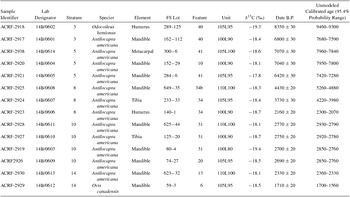
New Hogup Cave Radiocarbon Dates.

The front portion of the outer chamber is targeted because this area experienced less prehistoric movement of fill and, as a result, is better understood than the stratigraphically complex rear portion of the outer chamber and minimally excavated inner chamber. Specimens were selected from three diagonally contiguous units spanning the center of the cave: 100L90, 105L95, and 110L100 (Figure 2). Within these units, artiodactyl elements from Strata 3, 5, 8, 10, and 14 were submitted for dating. A single element from Stratum 5 in 105L100 was dated due to a lack of suitable artiodactyl specimens from the targeted unit 110L100. An element from Stratum 10 in 100L80 is also chosen for dating due to a conspicuous chronological gap in this otherwise well-dated unit.
Sample Preparation
Bone Collagen
Whole bone samples weighing ~500 mg were cleaned of surface contaminants and demineralized in 0.6N HCl at 4°C. The supernatant was decanted and replaced daily until a density gradient was no longer visible. Type 2 pure water is used throughout in glassware baked out at 550°C. Demineralizing whole rather than crushed bone produced a collagen pseudomorph. This process allowed preservation to be closely monitored and was complete when the supernatant was free of calcium phosphate, visible as a density gradient, and the sample was spongy when probed.
The pseudomorph was then rinsed to neutrality and soaked in 5 percent KOH, poured off, and replaced daily until the supernatant was clear. This procedure removed soil organic contaminants such as humic and fulvic acids. After acid and base extraction, the collagen pseudomorph was rinsed to neutrality and gelatinized in 5 ml of water (pH 3) for 24 hours at 90°C. Water-soluble and insoluble phases were separated with a 0.45 μm, Luer-Lok syringe filter, and the water-soluble phase was lyophilized and weighed to obtain a collagen yield.
δ13C and δ15N values were determined relative to V-PDB and AIR, respectively, on acid and base extracted bone collagen. Flash combustion in a Carlo Erba Elemental Analyzer118 CHN produced CO2 and N2, which were then measured against the appropriate reference gas on a Finnigan Delta Plus mass spectrometer at the University of Wyoming Stable Isotope Facility. Stable carbon and nitrogen isotope measurements and weight percent C:N values were obtained with a single sample combustion. Analytical precision was ± 0.1 ‰ for carbon and ± 0.2 ‰ for nitrogen.
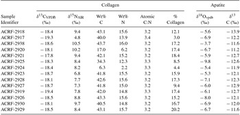
Ten mg of acid and base extracted bone collagen (protein) were forwarded to the International Chemical Analysis Lab Inc. AMS laboratory for dating. Two commonly used assays of protein preservation are reported in Table 3, weight percent collagen yield and atomic C:N ratios (Ambrose Reference Ambrose1990). Radiocarbon years before present were normalized with measured δ13C values. Despite relatively low carbon yields in ACRF-2920 and 2925, atomic C to N ratios were well within the 2.9–3.6 range considered indicative of bone collagen suitable for AMS radiocarbon dating (Table 3).
Collagen and Apatite Isotope Chemistry.

Bone Hydroxyapatite
Approximately 100 mg of powdered bone was soaked 24 hours in 3 percent hydrogen peroxide to remove organic materials, then rinsed to neutrality and dried. The sample was then soaked 30 minutes in 0.1 m buffered acetic acid to remove labile carbonates, rinsed to neutrality and dried.
Stable carbon and oxygen isotope values were determined, relative to V-PDB, gas bench online with a Finnigan Delta Plus XP continuous flow inlet mass spectrometer at the University of Wyoming Stable Isotope Facility.
Bayesian Modeling
Fourteen new dates and their synthesis with previously produced dates are presented using Bayesian chronological modeling. This approach enables the evaluation of calibrated radiocarbon dates (standardized likelihoods) with other information such as their stratigraphic position or associated cultural material (prior beliefs) to produce an informed probabilistic estimate of their age (posterior probability densities). Bayesian chronological modeling differs from less formal approaches to radiocarbon chronology interpretation in that it provides an explicit, reproducible representation of the assumptions used in evaluating a chronological sequence. The interpretive framework created by these models can be tested and modified iteratively as new information or dates become available (Bayliss et al. Reference Bayliss, Ramsey, van derPlicht and Whittle2007, Reference Bayliss, Brock, Farid, Hodder, Southon and Taylor2015; Bronk Ramsey Reference Bronk Ramsey2009a). Bayesian modeling is most prevalent in Old World archaeological contexts (see Bayliss Reference Bayliss2015 for review) but has been increasingly applied to prehistoric sites in the Americas (e.g., Kennett et al. Reference Kennett, Culleton, Voorhies and Southon2011; Levine and Stanish Reference Levine and Stanish2013; Miller and Gingrich Reference Miller and Gingerich2013; Miller et al. Reference Miller, Holliday, Bright, Graf, Ketron and Waters2014), including the Great Basin (Ives et al. Reference Ives, Froese, Janetski, Brock and Ramsey2014; Kennett et al. Reference Kennett, Culleton, Dexter, Mensing and Thomas2014).
We use OxCal v4.2 (Bronk Ramsey Reference Bronk Ramsey2009a) with outlier analysis (Bronk Ramsey Reference Bronk Ramsey2009b) to produce several Bayesian chronological models of dates from Hogup Cave. Each model is constructed by assigning groups of dated samples to sequential phases (analogous to Aikens's settlement units) based on their standardized likelihoods and prior information. The models do not assign an internal order to dates within each phase, but all dates must fall within the start and end boundaries of their phase. The end result is a chronological model of sequential groups of dates (phases) that do not overlap with one another.
The grouping of multiple strata into a single occupational phase is based on the assumptions that: (1) bulk sampling likely resulted in some dated samples that were composed of material from multiple strata, (2) interfaces between closely related strata (in time and vertical proximity) may not have always been correctly identified, and (3) some mixing of sediments (bioturbation, prehistoric movement of sediments, etc.) between strata may not have been identified during excavation, a fact acknowledged by Aikens (Reference Aikens1976).
The fit of a model in OxCal is typically assessed using agreement index values for both individual dates and the overall model. Agreement indices less than 60 percent indicate a poor fit and that a date (individual) or model (overall) should be rejected. However, if the number of outliers is high enough or sufficiently anomalous, the Markov Chain Monte Carlo (MCMC) simulation used in OxCal analysis may fail to converge, providing a null distribution for all dates. Anomalous dates can be manually removed from the model until the MCMC simulation converges with overall agreement > 60 percent (Higham et al. Reference Higham, Jacobi, Julien, David, Basell, Wood, Davies and Ramsey2010), but a similar outcome can be more systematically achieved using OxCal's outlier detection capabilities (Bronk Ramsey Reference Bronk Ramsey2009b).
Outlier analysis down-weights problematic samples, limiting their contribution to calculating parameters of the model such as boundaries and sequences of phases (e.g., Higham Reference Higham2011; Higham et al. Reference Higham, Jacobi, Julien, David, Basell, Wood, Davies and Ramsey2010, Reference Higham, Basell, Jacobi, Wood, Ramsey and Conard2012; Wood et al. Reference Wood, Arrizabalaga, Camps, Fallon, Iriarte-Chiapusso, Jones, Maroto, Rasilla, Santamaría, Soler, Soler, Villalneng and Higham2014, Reference Wood, de Quirós, Maíllo-Fernández, Tejero, Neira and Higham2016). One advantage of outlier analysis is that all dates can be initially included in the model, and dates determined to be outliers are reported in the model's output. We implement a “t” type outlier model specifying that we expect anomalous samples to be residual or intrusive outliers in time (as opposed to reservoir effects, 14C measurement errors, etc.). A long-tailed Student's t distribution with five degrees of freedom was used, given that little can be said about the expected offset of outliers (Bronk Ramsey Reference Bronk Ramsey2009b). Each sample is assigned an initial outlier probability of 5 percent, regardless of sampling or dating methods, an effort to produce as unconstrained a model as possible. This likely underestimates the outlier likelihood of bulk samples and radiometric dates compared to the newer AMS dates, but provides a conservative assessment of Hogup Cave's stratigraphic integrity that introduces as few biasing assumptions as possible.
Dating Results
The 14 new AMS dates are presented in stratigraphic order in Table 2. Contextual data are also provided. Dates are calibrated to a 95.4 percent probability range using IntCal13 (Reimer et. al Reference Reimer, Bard, Bayliss, Beck, Blackwell, Ramsey, Buck, Cheng, Edwards, Friedrich, Grootes, Guilderson, Haflidason, Hajdas, Hatté, Heaton, Hoffmann, Hogg, Hughen, Kaiser, Kromer, Manning, Niu, Reimer, Richards, Scott, Southon, Staff, Turney and Van DerPlicht2013) within OxCal 4.2 (Bronk Ramsey Reference Bronk Ramsey2009a). Collagen and apatite isotope chemistry is presented in Table 3 and sample preservation is well within acceptable ranges, indicative of the exceptional preservation characteristic of Hogup Cave.
Preliminary Model of New Dates
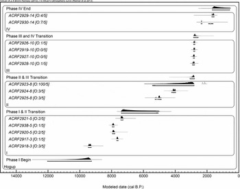
A model of the new radiocarbon dates from Stata 3, 5, 8, 10, and 14 is presented in Figure 6. Strata 3 and 5 are grouped into a single phase given their significant temporal overlap, but the overlying strata are each assigned to their own phase. One specimen (ACRF-2923) from Stratum 8 in 100L90 is as an outlier. The consistency of the Stratum 10 dates throughout the cave (including ACRF-2927, located above the outlier in 100L90) supports an interpretation of Stratum 10 as a relatively brief, distinct occupational phase occurring in the time between Stratum 8 and Stratum 14. The samples with near identical dates in Strata 5 and 10 have sufficiently distinct collagen and apatite isotope chemistry to identify them as coming from unique individuals. This establishes that the close association of dates from these strata cannot be dismissed as an error of sampling a single individual multiple times. The non-continuous sampling of the stratigraphic sequence represented by these dates precludes any interpretation of occupational continuity between these phases, so a single boundary has been placed between them.
Probability distribution of the newly reported dates in the preliminary model. Each date is identified by its lab number followed by its stratum. Outlier posterior and prior likelihood shown in brackets (first and second numbers respectively). Unmodeled, calibrated date distribution in white (standardized likelihood). Modeled posterior probability densities for dates and phase boundaries according to the chronological model in black with 95.4 percent probability range indicated by brackets. ACRF2923 is assigned a 100 percent likelihood of being an outlier given the model's prior assumptions, specifically that dates from Stratum 8 (Phase II) should occur between bracketing Phases I and III. Standardized likelihoods are largely obscured by overlapping posterior probabilities for non-outlier samples.

Modeling Results
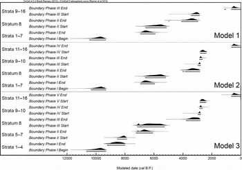
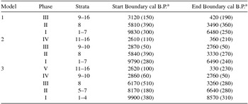
To examine the Hogup chronology using both previously published and new dates, we generate several Bayesian chronological models of increasing complexity. Multiple models demonstrate the influence of increasingly detailed prior assumptions on stratigraphic interpretations. Prior information used to group strata into occupational phases is discussed for each model. These include the horizontal and stratigraphic position of the sample, dates from encompassing strata, observations made during excavation, and associated cultural material. A summary of all models is shown in Table 4 and Figure 7. Models were also run with a charcoal outlier model (Bronk Ramsey Reference Bronk Ramsey2009b) applied to the four dated charcoal samples (GaK-1569, GX-1286, GaK-1563, and GaK-1567), but results were nearly identical to models employing a general outlier model for all specimens. Thus, reported models result from iterations using a general outlier model only.
A summary of the occupational phases in Models 1–3. Modeled phase boundaries in black, with the 95.4 percent probability range indicated by brackets. Corresponding strata occurring within boundaries to left. Model 2 is advocated as being the best-supported interpretation of Hogup Cave deposition and chronology given the available dates.

Model Summaries.

a Dates are rounded weighted means with standard deviations in parenthesis calculated in OxCal v2.4 (Bronk Ramsey Reference Bronk Ramsey2009a).
Model 1: Three-Phase Model
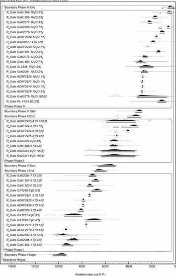
Model 1 (Figure 8) combines the 14 newly produced dates with 28 previously published dates classified into three occupational phases. Even though Stratum 10 appears distinct from over- and underlying strata, Model 1 combines the stratum with Strata 9 through 16 in Phase III in order to provide a conservative chronological model.
Model 1. A conservative, three-phase model. Four outliers were identified. Stratum 8 outliers AA20341 and AA20340 are likely from misidentified Stratum 6 sediments in the rear of the cave.

The model identifies four outliers: AA-20341, AA-23040, and ACRF-2923 from Stratum 8 and GaK-2076 from Stratum 10. Stratum 8 outliers AA-20341 and AA-23040 are interesting due to their location in the rear portion of the outer chamber within units 110L120 and 105L120 respectively (Figure 2). Stratum 7 was removed from this area prior to the deposition of Stratum 8, so that Stratum 8 directly overlays Stratum 6. Several passages in the excavation log indicate the difficulty of separating Strata 8 and 6 within these two excavation units:
The last two days trouble with the mixing of F34 [Stratum 8] and F39 [Stratum 6] levels was eliminated by careful and slow work in Sq. 105L115” [Notes, Feature 1, p. 96].
F34 continues to be confusing excavations in Sq. 105L120 today [Notes, Feature 1, p. 96].
This profile [110L line, west wall of units 105L120 and 105L125] should also help resolve the problems that have occurred with F34 [Stratum 8] and F39 [Stratum 6]. As it appears now, 5 or 6 truncations of strata occur in the same general horizontal area. Beneath the arch which separates the back and front of the band and front of the cave, roughly from 110 to 120 on the 110L line, these truncations have an almost interlocking finger type pattern [Notes, Feature 1, p. 98].
The location of these outliers within the site and their overlap with Stratum 6 dates GaK-1563 and Gak-1567 suggest that they are likely from Stratum 6, which excavators systematically misidentified as Stratum 8 while excavating the back of the outer chamber.
The Stratum 8 AMS derived outlier ACRF-2923 continues to be identified as an outlier in the preliminary model. Stratum 10 outlier GaK-2076 is clearly much earlier than the other dates from Strata 10 through 16 in Phase III.
Model 2: Four-Phase Model
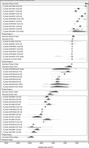
Model 2 builds upon Model 1 by incorporating the prior assumption from the preliminary model that Stratum 10 was deposited during a relatively short, discrete occupational phase (Figure 9). The agreement of previously produced GaK-2081 and SI-2338 with our four new dates from Stratum 10 further bolsters this assumption. In addition to the tight date distribution, the relative lack of pottery in Stratum 10 and below (14 sherds or 6 percent) compared to Stratum 12 and above (350 sherds or 94 percent) also supports the separation of these upper strata into two chronological periods (Aikens Reference Aikens1970:32; Reference Aikens1976). The wide margin of error reported for the two 1970s conventional radiocarbon dates is significantly reduced in the model's output by the start and end boundaries of Phase IV.
Model 2. This model is advocated for research at Hogup Cave in light of presently available dates. The tight distribution of Stratum 10 dates implies a short, discrete occupation, providing a useful stratigraphic boundary separating Phases II and IV. Two additional outliers were added to those identified in Model 1 for a total of six outliers. Strata 12–16 in Phase IV show little internal coherency. It is uncertain whether this is due to older dating methodologies that produced these dates or is an indicator of mixing between Phase IV strata.

The addition of a fourth occupational phase between Stratum 8 and Stratum 12 creates two new outliers (RL-413-9 and GaK-1560). The Stratum 9 Phragmites sp. reed sample RL-413-9 is of an appropriate age for an arrow shaft, as suggested by Madsen and Berry (Reference Madsen and Berry1975), but its stratigraphic position below the pre-pottery Stratum 10 is almost certainly intrusive (Aikens Reference Aikens1976). With only one dated, likely intrusive, sample from Stratum 9, there is little information to indicate whether the stratum should be considered part of Phase II or Phase III. It is tentatively assigned to Phase III in this model due to the similarity of macroscopic plant remains between Stratum 9 and overlying strata (Harper and Alder Reference Harper, Alder and Aikens1970). The overlapping dates for Strata 12, 14, and 16 suggest a wide degree of mixing in the uppermost component of the site. It is possible that this mixing incorporated residual material from lower strata into the bulk sample of grass, sticks, and shredded bark that produced the Stratum 12 outlier date GaK-1560.
Model 3: Five-Phase Model
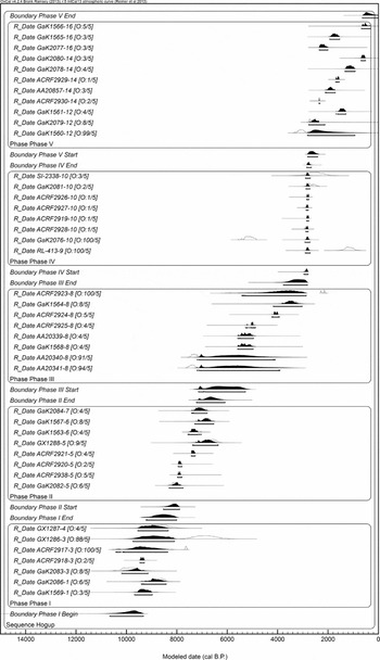
The final chronological model (Figure 10) divides the yet unaddressed lower component of the site into two separate phases: Strata 1 through 4 and Strata 5 through 7. This model is presented to demonstrate the potential hazard of overconstraining a Bayesian depositional model with poorly supported prior assumptions. The addition of a fifth phase necessitates the assumption that Stratum 3’s ACRF-2917 and GX-1286 (50 percent of the stratum's dates) are intrusive from above strata. However, unlike previously identified outliers, there is little evidence to support this. Despite the agreement of early Stratum 5 dates, the 1,500-year span of Strata 5 through 7 and internal reversals form a poor depositional boundary in contrast with the six well-aligned dates from Stratum 10 that subdivide Phase IV and V. Unlike AA-20340 and AA-20341 (where excavation notes and their chronological overlap indicate that they are likely from Stratum 6 instead of 8), there is no evidence to suggest that ACRF-2917 and GX-1286 are intrusive samples from overlying strata. There are few differences in the type of artifacts found between Strata 1 through 4 and Strata 5 through 7, unlike the sharp contrast in the presence of temporally diagnostic pottery between Stratum 10 and Stratum 12. A slight shift in the relative contribution of obsidian sources used for tools was reported by Hughes (Reference Hughes2015) to have occurred beginning in Stratum 4, but it was statistically insignificant.
Model 3. Two outliers were identified in addition to those from previous models for a total of eight outliers. Both are from Stratum 3, rejecting half the stratum's dates as outliers, a tenuous proposition. There is also less support for splitting Strata 1–7 into two phases due to their wide date distribution compared to that of Stratum 10. Additionally, there is little artifactual support for an occupational split between these strata.

Discussion
Modeling Summary
Modeling of only the new dates suggests four separate occupational phases (Figure 6). The addition of the previously published dates largely agrees with this interpretation (Model 2, Figure 9) as the most parsimonious representation of occupational phases given available data. The three-phase Model 1 (Figure 8) is too conservative, failing to take advantage of Stratum 10’s tightly grouped dates and differences in artifact composition relative to overlying strata. The five-phase Model 3 (Figure 10) makes unsupported assumptions by differentiating Stratum 3 from artifactually similar loosely dated strata above. The five-phase model is certainly possible, but unjustified without dating additional samples from lower strata.
Outlier Dates and Stratigraphic Integrity
Three AMS-derived dates are flagged as outliers in the best supported Model 2, all of which come from Stratum 8. As discussed, the two outliers AA-20341 and AA-20340 are most likely due to misidentification of Stratum 6 as Stratum 8 during excavation of the complex stratigraphy in the rear portion of the outer chamber. In contrast, there is no clear explanation for the other Stratum 8 AMS outlier ACRF-2923 (also Stratum 3’s ACRF-2917, flagged in Model 3 but accepted in Models 1 and 2). This suggests that there was likely a degree of undetected mixing or stratigraphic misidentification, some of which was expected by Aikens (Reference Aikens1970:26–29, Reference Aikens1976) given the immense scale of the excavation.
It is less clear whether the three older conventional radiocarbon dates (outliers in Model 2’s RL-413, GaK-2076, and GaK-1560; also GX-1286 in Model 3) are indicators of stratigraphic mixing, excavation error, or issues with older dating methodologies (bulk sampling, necessity of including non-anthropogenic material for adequate sample size, measurement error, etc.). The influence of these factors can be potentially evaluated by assessing the chronological hygiene of the older samples (e.g., Pettitt et al. Reference Pettitt, Davies, Gamble and Richards2003) and their agreement with the newer AMS dates, which are not subject to the same pitfalls. Similar vetting of regional (Higham Reference Higham2011; Nolan Reference Nolan2012; Taché and Hart Reference Taché and Hart2013; Wilmshurst et al. Reference Wilmshurst, Hunt, Lipo and Anderson2011) and stratigraphic (Goebel et al. Reference Goebel, Graf, Hockett, Rhode, Kornfeld, Vasil'ev and Miotti2007) radiocarbon sequences often reject upward of half of dates due to uncertain archaeological contexts, the material sampled, or older dating methodologies. At present, such a narrow interpretation excluding conflicting dates at Hogup Cave would be premature, possibly overconstraining the duration of strata and inadvertently obscuring the extent of stratigraphic mixing at the site (e.g., Stratum 3 in Model 3). We advocate a more balanced interpretation of Hogup Cave chronology (Model 2) until additional dates can be produced.
Regional Implications and Future Work
Early–Middle Holocene Transition
This time period is of particular interest because it spans the transition from more mesic Early Holocene conditions to hotter and drier conditions characteristic of the Middle Holocene Great Basin (Antevs Reference Antevs1955; Grayson Reference Grayson2000, Reference Grayson2011:219–242; Jones and Beck Reference Jones, Beck, Bousman and Vierra2012; Kelly Reference Kelly1997). An analysis of macroscopic plant remains excavated from Hogup Cave reflects this transition, with mesic and upland grasses declining in prevalence after Stratum 3 and then rebounding in Late Holocene Stratum 9 (Harper and Alder Reference Harper, Alder and Aikens1970:227–228). The loss of productive marsh land and the small remnants of Pleistocene lakes in the region coincided with a greater reliance on small seeds, changes in mobility, and other shifts in material culture often referred to as the Paleo- or Pre-archaic to Archaic transition (Elston and Zeanah Reference Elston and Zeanah2002; Elston et al. Reference Elston, Zeanah and Codding2014; Grayson Reference Grayson2011). Establishing separate Early and Middle Holocene occupational phases, likely split at Stratum 4 or Stratum 5, would provide a means of studying how inhabitants of Hogup Cave adapted to this shifting climate regime.
The presence of a distinct Early Holocene occupational phase is unclear due to the out-of-sequence Stratum 3 dates ACRF-2917 and GX-1286. Additional dates from Strata 3, 4, and 5 will help to clarify the relationship between these strata and to determine whether these two dates are unique outliers (Figure 10, Model 3) or reflect the presence of stratigraphic mixing (Figures 9 and 10; Models 1 and 2). The agreement of early Stratum 5 dates (Gak-2082, ACRF-2938, and ACRF-2920) indicates a distinct start to the deposition of the stratum, but the single conventional radiocarbon date from Stratum 4 and the span of the four Stratum 3 dates obscure the larger stratigraphic relationship of these deposits.
Middle Holocene Occupational Hiatus
The break in occupation suspected by Aikens (Reference Aikens1970:27–28) between Stratum 7 and 8 is reflected in all three models. Centered around 6000 cal B.P. and spanning over a thousand years, a hiatus at this time would coincide with a hypothesized regional depopulation (Jones and Beck Reference Jones, Beck, Bousman and Vierra2012:112–113; Louderbeck et al. Reference Louderback, Grayson and Llobera2010), possibly as a result of increasingly xeric climatic conditions during the Middle Holocene (Broughton et al. Reference Broughton, Byers, Bryson, Eckerle and Madsen2008; Grayson Reference Grayson2000). However, the lack of dates from this time period could simply be an artifact of temporal and volumetric undersampling.
With only five widely dispersed dates accepted from Stratum 8, there is a high degree of uncertainty regarding the boundary that spans the suspected hiatus period (Phase II Start, Models 1 and 2; Phase III Start, Model 3). Although not taken into account in the models, this uncertainty is further compounded by the observation that Stratum 8 is the thickest stratum with a maximum depth just under a meter (Figure 3) yet has an equal number of or fewer dates than several thinner strata (Strata 5, 10, and 14). Thus the low or null posterior density of dates around 6000 cal B.P. may be an artifact of too few dated samples from such a large volume of sediments deposited over a long period of time. Further dating of samples from Stratum 8 deposits at the front of the outer chamber (south of 110 grid north) can correct this undersampling problem. If the chronological gap between Stratum 7 and Stratum 8 still persists with the addition of more dates, the likelihood that this represents an actual occupational hiatus increases.
The strong suspicion that the horizontally adjacent Stratum 8 outliers AA-20341 and AA-20340 are both from Stratum 6 implies that differences in the depositional sequence from this area of the cave beginning around 110 grid north may not have been correctly identified. There are two potential solutions to this problem. At present, concerns over the stratigraphic integrity of this area could be avoided by simply excluding this material from analyses. This would affect only a small proportion of the artifact assemblage, given the limited area excavated in this portion of the cave relative to the entire excavation. Alternatively, a systematic dating of samples beginning at 105 or 110 grid north and working toward the rear of the chamber could detect whether systematic misidentification of strata took place in this area. If this were in fact the case, producing enough dates would enable the construction of an alternative chronological model for this rear portion of the site, preventing the need to exclude material from analysis.
The Fremont Complex and Numic Expansion
The Late Holocene period in which Strata 12 through 16 (Phase IV, Model 2; Phase V, Model 3) were deposited was a particularly dynamic one in the eastern Great Basin, with changes in mobility, technology, and subsistence (Grayson Reference Grayson2011:324–332). One of the most notable shifts observed is the transition from Late Archaic hunter-gatherer lifeways to the more sedentary Fremont maize agriculturalist sometime between 2000 and 1500 cal B.P. (Madsen and Simms Reference Madsen and Simms1998). Stratum 10, suggested by Madsen and Berry (Reference Madsen and Berry1975:395) to date to the Fremont era, is several centuries too early for the appearance of maize in the region (let alone agricultural intensification). Instead, Models 2 and 3 indicate that the Fremont Complex likely appeared sometime during the deposition of Strata 12 through 16, in a similar manner to that originally proposed by Aikens (Reference Aikens1970).
At some point within the last 1,000 years, the people associated with the Fremont archaeological complex were replaced by Numic speaking populations who, as part of the larger Numic Expansion (Bettinger and Baumhoff Reference Bettinger and Baumhoff1982; Kaestle and Smith 2001; Kelly Reference Kelly1997; Lamb Reference Lamb1958), colonized and continued to inhabit the Great Basin through the time of Euro-American contact. This event remains a central focus of current research, though poor chronological controls on the timing of the expansion continue to hinder progress.
Unfortunately, the precise timing and manner of transition between the Late Archaic, Fremont, and Numic periods as represented at Hogup Cave is still unclear. Assessing the occupational continuity and depositional timing of Strata 12 through 16 would help to address these questions, but available dates from these strata have numerous reversals and large, overlapping distributions. At this point, it is clear that the transition from Late Archaic to Fremont and then to Numic-speaking peoples occurred during the deposition of Strata 12 through 16, but there is little in the radiocarbon dates to support any additional details. The wide span of the three AMS dates from Stratum 14 (AA-20957, ACRF-2929, and ACRF-2930), from 2360 to 1560 cal B.P. suggests that the overlap of the site's upper strata cannot be dismissed as an error of bulk sampling or conventional radiocarbon measurement alone. Determining whether the stratigraphic integrity of these upper strata is sufficiently intact to provide an intelligible record of the dramatic changes in region over the last 2,000 years will require further AMS dating of anthropogenically deposited, single-entity samples from Strata 12 through 16.
Conclusions
The spatially variable stratigraphic sequence of Hogup Cave is complex but well documented in excavation logs and published excavation findings. This analysis demonstrates the necessity of close attention to such details when evaluating radiocarbon chronologies and the ability to account for such complexities through Bayesian chronological modeling. The use of stratigraphic knowledge and other prior information in constructing and designing these models is an interpretive exercise. However, the approach is explicit in its assumptions and provides a useful framework to test and modify older chronologies in response to new dates and findings.
In the past, lingering concerns over stratigraphic integrity and chronology at Hogup Cave have limited the site's potential scientific contribution. The careful evaluation of previous dates, 14 new dates reported here, and the synthesis of these data into four occupational phases described by Model 2 (Figure 9) have addressed some of these concerns. The exercise has also raised several questions regarding the site's stratigraphy and occupational history, which, once addressed with additional dates, may reveal chronological resolution surpassing that suggested by this study and may inform on several subjects of significant interest in Great Basin prehistory.
Acknowledgments
We thank the Natural History Museum of Utah Anthropology Collections staff for access to Hogup faunal material and records. Permission to cite unpublished Hogup Cave photos and field notes was granted by the University of Utah Archaeological Center (UUAC). Thank you to the UUAC lab group for helpful comments on earlier versions of this manuscript and to Allison L. Wolfe for providing the Spanish abstract translation. Finally, we thank the three anonymous reviewers for their suggestions and feedback, from which this paper has undoubtedly benefited. Funding for this work comes from the University of Utah Research Foundation.
Data Availability Statement
Radiocarbon dating and isotope chemistry lab reports produced in this study are curated by the Archaeological Center Research Facility in the Department of Anthropology, University of Utah. The Hogup Cave excavation notes are curated by the University of Utah Archaeological Center. Artiodactyl faunal remains sampled for the dates reported here, as well as the cited destructive analysis request form, are curated at Anthropology Collections, Natural History Museum of Utah. Please contact the corresponding author if assistance is needed accessing these data.
Supplemental Materials
Supplemental materials are linked to the online version of this paper, which is accessible via the SAA member login at https://doi.org/10.1017/aaq.2017.2.
Supplemental Figure 1. Idealized depiction of depositional sequence.