Introduction
Over the recent decades, radiocarbon (14C) dating of various organic samples has been used as a basis for the construction of precise temporal ranges for specific cultures in Russia. This includes Late Bronze Age cultures of the Ural region (Epimakhov et al. Reference Epimakhov, Zazovskaya and Alaeva2024) or specific sites, like the Kordyshiv cemetery in western Ukraine (Makarowicz et al. Reference Makarowicz, Goslar, Szczepanek, Yahodynska, Ilchyshen, Kozak, Romaniszyn, Niebieszczanski, Rud and Pospieszny2024). Radiocarbon dates have enabled the revision of absolute chronological frameworks for the Eneolithic (Kiosak et al. Reference Kiosak, Bodean, Kotova, Szidat and Tinner2024), the Bronze Age (Epimakhov et al. Reference Epimakhov, Zazovskaya and Alaeva2024) and later periods (Seregin et al. Reference Seregin, Svyatko, Barrett, Demin, Matrenin, Papin and Reimer2024) in various regions.
The accelerator mass spectrometry (AMS) technique for dating small (mg size) samples has significantly enlarged the list of available dates and enabled researchers to verify or obtain more detailed chronologies measured by the conventional method based on radiometry. Different types of organic materials can be subject to dating issues such as an old wood effect for wood or charcoal or a reservoir effect for bone (Kim et al. Reference Kim, Wright, Kim and Oh2019; Lanting et al. Reference Lanting, Aerts-Bijma and van der Plicht2001; Philippsen Reference Philippsen2013; van der Plicht et al. Reference van der Plicht, Shishlina and Zazovskaya2016).
In the recent past, the focus of our studies was on the chronology of the Bronze Age cultures in the northwestern Caspian region based on the stratigraphy of kurgans and available 14C data. The impact caused by possible reservoir effects was investigated (Shishlina et al. Reference Shishlina, Sevastyanov, Zazovskaya and van der Plicht2014; van der Plicht et al. Reference van der Plicht, Shishlina and Zazovskaya2016), leading to corrections for the chronological periods. This resulted in an absolute chronology of the Bronze Age cultures for the northwestern Caspian region based on extended series of conventional and AMS 14C dates (Shishlina Reference Shishlina2008). However, all samples dated were selected from funerary contexts, in particular, ancient burials from the kurgans. Our chronological framework complements the chronology of the Bronze Age cultures in the southern part of eastern Europe based mainly on conventional dates and a number of AMS 14C dates reported by V. A. Trifonov (Trifonov Reference Trifonov and Yu2001).
Though radiocarbon dating has been applied to regional studies of the Eurasian Steppe (Maryenkina et al. Reference Maryenkina, Mimokhod and Zelentsova2023; Trifonov Reference Trifonov and Yu2001), the chronology of prehistoric cultures in the Lower Don is still mainly based on stratigraphic data as well as comparative and typological methods. These are based on typo-chronological schemes defined by short-lived artifacts, funerary rites and “standard” archaeological dating methods of relative chronology, i.e. stratigraphy of kurgans. For example, the analysis of a group of Eneolithic and Early Bronze Age sites in the Don, Manych and Yeya interfluve (Yatsenko Reference Yatsenko2015) used the cultural attribution of the stratigraphic groups to identify their chronological order. Therefore, cultural chronologies built for the analyzed region do not have a well-defined temporal framework. Such analysis of important cultural groups in one of the Lower Don key sub-regions (the Don, Manych and Yeya interfluve) does not allow us to conduct a detailed comparison of the Eneolithic and Yamnaya groups in this area with other cultural groups, such as those that inhabited other Lower Don or neighboring regions. For the latter, chronological ranges are determined for the entire suite of Eneolithic, Bronze Age, Early Iron Age cultures using radiocarbon dates (Higham et al. Reference Higham, Warren, Belinskij, Härke and Wood2010; Kantorovich and Maslov Reference Kantorovich and Maslov2008).
More importantly, the Early Eneolithic and Yamnaya burials frequently have similar features of the funerary rite and no funerary offerings. It may be difficult to assign them to a specific culture. In these cases, it is only 14C dating of human bones that can help ascribe a specific burial to the Eneolithic or Yamnaya culture. The same situation is also typical for a number of Early Iron Age burials where the deceased lie in a supine extended position with no funerary offerings; therefore, it is difficult to refer them to the Cimmerian, Scythian or Sarmatian culture without having radiocarbon dating results.
Another problem arises because the archaeologists studying various populations who lived in the Lower Don in different periods of the Iron Age can refine absolute chronology data using diagnostic artifacts such as coins, imported goods as well as written sources. They do not use the radiocarbon dating method. For example, there are very few radiocarbon dates available for organic materials from the Sarmatian graves of the Early Iron Age in the Volga and Don regions (Skripkin Reference Skripkin2017, 83). In addition, 14C dating of the sites dating to the first millennium BC is hampered by the so-called “Hallstatt plateau” in the calibration curve that translates 14C dates into calendar dates. An example is the dating of the Sarmatian Filippovka kurgan in the Ural region (Zaitseva et al. Reference Zaitseva, Bokovenko, Alekseev, Chugunov and Scott2005, 185–187). Nevertheless, radiocarbon dating of the samples from the sites dating to the transition period from the former era to the current era and the subsequent periods has produced promising results (Zaitsev et al. Reference Zaitsev2013). There are practically no 14C data available for the medieval sites located in the Lower Don region either.
The studied region, i.e. the Sal steppes and the northern fringes of the Kuma-Manych Depression, witnessed important historical events marking periods of emergence and development of the Lower Don populations, though the chronological boundaries of various cultural groups of the prehistorical and medieval periods have not been clearly defined. Temporal ranges are not correlated or are in poor agreement with each other. Therefore, establishing a precise chronology of the cultures of the Eneolithic, the Bronze Age, the Iron Age and the Middle Ages in the Lower Don in the south of Russia remains a crucial issue for archaeological studies.
The main objective of this study is to construct a robust absolute chronology for the prehistoric and medieval cultures in the Lower Don region based on precise AMS 14C dates. To achieve this task, we selected and radiocarbon dated different carbon-rich organic samples that originated not only from the burials of various historical periods but also from the settlements, i.e. seasonal campsites located in one of the key regions of the Lower Don, i.e. the Sal steppes and the northern area of the Kuma-Manych Depression. We then compared the AMS 14C dates from these two types of sites, used Bayesian modeling of the dates from the Yamnaya, Early Catacomb, Catacomb and Lola sites to obtain an absolute chronology for the Early and Middle Bronze Age periods. For the Scythian and Sarmatian sites this was done for the Early Iron Age. We discuss chronological ranges for the cultures of the Eneolithic and the Middle Ages as separate cases, because of the limited amount of 14C dates available for these cultures. The intervals proposed for the cultural groups are based on median values of the AMS 14C dates. Our results make it possible to refine the cultural chronologies for the Sal steppes and the northern area of the Kuma-Manych Depression and assess the cultural regional continuity or discontinuity related to the emergence and spread of many cultures. As the populations of these regional cultures developed, they facilitated dissemination of many technological and cultural innovations, triggered migrations and established steppe socio-political organizations.
In addition, comparison of the chronologies relating to the Eneolithic, Early and Middle Bronze Age cultures in the Lower Don region with previously discussed Bronze Age cultures in the northwestern Caspian steppes (Shishlina Reference Shishlina2008) enable a more precise reconstruction of historical processes and events in the eastern European steppes and Russian Plain during several millennia.
Geographical background and archaeological context
The Lower Don region is located in the dry steppe belt in the south of the Russian Plain. The region investigated includes the westernmost part of the Middle Yergueni Hills and the northern periphery of the Sal-Manych separating ridge or watershed (Sal-Manych Ridge). Two large areas showing a different natural environmental development and geomorphology are selected. The first area is the basin of the Sal river which is a left tributary of the Don. This river (known as the Dzhurak-Sal) flows in the Dzhurak balka on the western slopes of the Yergueni Hills (Republic of Kalmykia) near the border with the Rostov region. After 180 km, the river is joined by the Kara-Sal, and its name is changed to Sal. The second area is the northern fringes of the Kuma-Manych Depression, showing numerous balkas cutting through the Sal-Manych Ridge from north to south. It is located further south of the Sal steppes.
Sites from various historical periods have been discovered in the steppes of the Sal-Manych Ridge and the Kuma-Manych Depression. In the 1960s flint tools dating to the Mesolithic (Praslov Reference Praslov1971) were found along the northern fringes of the Manych valley on the western slopes of the Yergueni Hills. Subsequently, excavations of the kurgans with burials dating to the period between the Early Bronze Age and the late Middle Ages began (Parusimov Reference Parusimov1997). From the end of the 20th century to the present kurgans and burials have been the main investigated archaeological sites in the region. The Steppe Archaeological Expedition of the State Historical Museum in Moscow has excavated 44 kurgans from 12 burial grounds in this area since 2003. The analysis of funerary rites and offerings assigned these kurgans and burials to the Steppe Eneolithic, Yamnaya, Early Catacomb, Western Manych and Eastern Manych Catacomb, Lola, Sarmatian, Kuman, Golden Horde cultural traditions (Leonova et al. Reference Leonova, Shishlina, Loboda and Soloshenko2021; Shishlina and Kazarnitsky Reference Shishlina and Kazarnitsky2023; Strokov et al. Reference Strokov, Shishlina and Leonova2022). Their locations are shown in Figure 1.
Locations of the kurgan burial grounds and seasonal campsites: 1 – Bolshaya Elista-1; 2 – Volochaika-4; 3 – Chikalda-1; 4 – Chikalda-6; 5 – Chikalda-7; 6 – Temrta-1; 7 – Tseketa-3; 8 – Keresta-5; 9 – Temrta-5; 10 – Peschany I; 11 – Peschany IV; 12 – Peschany V; 13 – Ulan IV; 14 – Sukhaya Termista I; 15 – Sukhaya Termista II; 16 – Temrta I; 17 – Temrta IV; 18 – Temrta V; 19 – Nemashkalovo; 20 – Balka Bolshaya Elista; 21 – Ulan-4.

During the project, a survey revealed a new type of sites: seasonal short-term campsites (Shishlina et al. Reference Shishlina, Azarov, Dyatlova and Roslyakova2018, Reference Shishlina, Leonova, Kalinin, Shishlina and Kazarnitsky2023a). We conducted small-scale excavations (using prospect trenches) at the locations with the highest concentration of surface finds in the Sal river valley (Temrta-1, Temrta-5, Bolshaya Elista-1, Tseketa-3 and Ulan-4 sites) and the Manych river valley (Volochaika-4, Chikalda-1, Chikalda-6, Chikalda-7, and Keresta-5 campsites) and discovered occupation layers partially disturbed by erosion processes. These layers were mixed, containing bones of wild and domesticated animals, fragments of flint tools and ceramics located at different depths. Based on comparative and typological analysis of diagnostic items such as decorated ceramics, flint tools and iron artifacts, we could attribute some campsites to various historical periods. Population groups of the Eneolithic, Yamnaya, Catacomb, Early Iron Age cultures and the Migration period as well as Middle Ages nomads visited these sites occasionally. On the whole, though, occupation layers at the campsites yielded very few objects. They were destroyed by erosion and diagnostic finds are scarce. We determined the season when these sites were used and concluded that these sites were occupied by the Eneolithic, Yamnaya and Catacomb pastoral groups from early spring to late autumn. However, throughout the Early Iron Age, various pastoral groups stayed at these campsites not only during the warm time of the year, but also in the winter. This resulted in the presence of carbon-rich organic samples at the funerary and settlement sites, enabling large scale 14C dating by AMS.
Methods and samples
For radiocarbon dating, the datable fraction of the sample needs to be isolated from the sample, and contaminations need to be removed. For organic samples like wood, charcoal, textile and others we employed the standard AAA pretreatment method (acid-alkali-acid). Summarized, the procedure consists of the following steps:
(i) Acid (HCl) in order to remove soil carbonate and possibly infiltrated humic acids; (ii) Alkali (NaOH) to remove, e.g. soil humates; (iii) Acid (HCl) to remove any atmospheric CO2 absorbed during step.
For bone samples, the datable fraction is collagen. The collagen is prepared using a protocol originally developed by Longin (Reference Longin1971). To extract the collagen fraction from bone samples, bone fragments are first subject to a mild AAA pretreatment. The extract is exposed to NaOH to eliminate humic acids and subsequently transferred into gelatin.
For a thorough recent treatise on pretreatment protocols we refer to Dee et al. (Reference Dee, Palstra, Aerts-Bijma, Bleeker, de Bruijn, Ghebru, Jansen, Kuitems, Paul, Richie, Spriensma, Scifo, van Zonneveld, Verstappen-Dumoulin, Wietzes-Land and Meijer2020), describing the protocols used in Groningen.
The pretreated and purified sample fraction is combusted into CO2 gas using an Elemental Analyzer (EA), coupled to an Isotope Ratio Mass Spectrometer IRMS). This EA/IRMS also provides the value of the stable carbon isotope (13C), and the stable nitrogen isotope (15N) when the EA is set to N2 gas analysis.
For 14C analysis, part of the CO2 is routed to a cryogenic trap to collect the samples for further processing. The CO2 is transferred into graphite powder by the reaction CO2 + 2H2 → 2H2O + C at a temperature of 600 ºC and using Fe powder as a catalyst.
Part of the samples were graphitized using the AGE 3 automated graphitization system (Ionplus) which is coupled with EA and IRMS. The cleaned samples were weighed into tin capsules and combusted in an elemental analyzer that transfers only the CO2 in helium to the AGE 3 graphitization system and to the IRMS (5% СO2). The amount of CO2 is kept constant to provide constant CO2/H2/Fe ratios for the graphitization at 580 ºC (0.9 mg carbon, 4.2 mg iron, H2/CO2 ratio = 2.3). The water formed from the reduction is frozen in a Peltier cooled trap (about –5 ºC). The reaction is stopped automatically after two hours when residual gas pressures are stable (Wacker et al. Reference Wacker, Němec and Bourquin2010). The IRMS provides the value of the δ13C and δ15N values for the same sample. Next, the graphite is pressed into target holders for the ion source of the AMS (accelerator mass spectrometer). The above is a general description of the AMS pretreatment method. This article presents dates obtained from different laboratories; details in pretreatment methods do exist. The AMS method is based on mass spectrometry, enabling dating of small samples (typically 1 mg of carbon). All dates discussed are measured by AMS, and not by the conventional method which is the original method developed in the 1950s and is based on radiometry. This requires large samples (typically 1 g of carbon). For general references, see e.g. Jull (Reference Jull and Elias2013) and Cook and van der Plicht (Reference Cook, van der Plicht and Elias2025) for AMS and conventional dating, respectively.
The 14C (radiocarbon) dates are reported by convention as follows (Mook and van der Plicht Reference Mook and van der Plicht1999):
-
i) the activity is measured relative to that of a standard (reference) material, representing “recent” which was chosen as AD 1950;
-
ii) the (originally used but not correct) value of the half-life of 5568 years remains to be used;
-
iii) isotopic fractionation is corrected for by normalizing samples to the same 13C scale, for which the value δ3C = –25‰ has been chosen;
-
iv) 14C dates calculated this way are expressed in the time unit BP.
The consequence of the convention is that radiocarbon dates have their own independent and defined timescale, and calibration is needed to translate BP dates into calendar dates. For this, calibration curves are available which are updated regularly, the present one being IntCal20 (Reimer et al. Reference Reimer, Austin, Bard, Bayliss, Blackwell, Bronk Ramsey, Butzin, Cheng, Lawerence Edwards, Friedrich, Grootes, Guilderson, Hajdas, Heaton, Hogg, Hughen, Kromer, Manning, Muscheler, Palmer, Pearson, van der Plicht, Reimer, Richards, Scott, Southon, Turney, Wacker, Adolphi, Buntgen, Capano, Fahrni, Fogtmann-Schulz, Friedrich, Köhler, Kudsk, Miyake, Olsen, Reinig, Sakamoto, Sookdeo and Talamo2020; van der Plicht et al. Reference van der Plicht, Bronk Ramsey, Heaton, Scott and Talamo2020). The calibrated ages are reported in calBP where calBP is defined as calendar years relative to AD 1950.
The stable isotope contents are reported in delta values, which for 13C is a measure of the difference of the 13C/12C isotope ratio of a sample and that of a standard (or reference) material:
δ13C = (13C/12C)sample/(13C/12C)reference – 1 (×1000‰).
For 13C, the reference is an international standard limestone known as Pee Dee Belemnite, or V-PDB which has an accurately measured absolute 13C concentration (Mook Reference Mook2006).
For bone collagen, the content of the stable isotope 15N is also measured:
δ15N = (15N/14N)sample/(15N/14N)reference – 1 (×1000‰).
For 15N, the reference is ambient air (Mook Reference Mook2006).
Samples from 11 kurgan burial grounds and 10 seasonal campsites (Figure 1) were analyzed for this research project. The list of sites is shown in Table 1.
Archaeological seasonal campsites and burial grounds.

When selecting the samples from kurgans, we took into account stratigraphic and horizontal patterning of the burials that helps us to determine the primary burial over which the mound was constructed as well as relative sequence of other secondary burials with additional mounds built over them. An example of stratigraphic patterning of the burials in kurgan 15 (13) from Peschany IV is shown in Figure 2. We note that it was not always possible to determine the stratigraphic patterns and thus temporal sequences of secondary burials of the Early Iron Age made in the earlier kurgans. More importantly, broad chronological intervals proposed for some types of diagnostic goods (the so-called chrono-indicators) such as bronze vessels, fibulae, and weapons (Strokov et al. Reference Strokov, Shishlina and Leonova2022) are commonly used for the Russian Early Iron Age. This is based on traditional typo-chronological schemes defined by artifacts without taking into account the possibility that such goods could be used outside the regions where they had been produced for a much longer period. In addition, absence of funerary offerings in a number of Early Iron Age burials or discoveries of looted burials do not make it possible to determine the precise moment of burial.
Peschany IV, kurgan 15 (13): 1 – planigraphic pattern of graves; 2 – stratigraphic pattern of graves 6 (primary) and 3 (secondary); 3 – grave 3, West Manych Catacomb culture; 4 – grave 5, Yamnaya culture; 5 – stratigraphic pattern of graves 6 (primary, Yamnaya), 5 (first secondary, Yamnaya) and 3 (second secondary, West Manych Catacomb).

In order to determine the chronological sequence of the burials, the following samples were selected: human and animal bones, fragments of items made of animal bones (bone pins), wood fragments, birchbark, charcoal, organic residues such as encrusted deposits adhering to the interior or exterior surface of a vessel, plant remains, and fragments of silk and cotton textile. We preferred paired samples such as human bones and terrestrial samples from the same burial for radiocarbon dating. This way the size of a possible reservoir effect for bones can be determined by comparing their 14C dates with terrestrial samples. For human bones conserved under good conditions, their age and sex were determined in the Museum of Anthropology and Ethnography (Kunstkamera) of the Russian Academy of Sciences using standard forensic and anthropological methodologies (Alekseev and Debets Reference Alekseyev and Debets1964; Alekseev Reference Alekseyev1966). The animal bones were identified to the level of species employing the method of comparative analysis of the bones with the use of a benchmark collection of modern animals kept in the archaeological laboratory of Samara Social and Pedagogical University (Roslyakova Reference Roslyakova, Shishlina and Kazarnitsky2023). To exclude an old wood effect, we performed xylotomic analysis of wood. For well preserved wood we determined the taxonomic affiliation. We used a reference dataset from the wood collection of Moscow State University (Shishlina et al. Reference Shishlina, Strokov, Kupriyanov, Soloshenko and Kiseleva2023b) and atlases for the identification of trees and shrubs of Russia (Benkova and Schweingruber Reference Benkova and Schweingruber2004) and the Eastern Mediterranean species (Akkemik and Yaman Reference Akkemik and Yaman2012). When possible, the species of the plant remains were identified using a phytolith method based on a standard methodology described in (Kirillova et al. Reference Kirillova, Zanina, Narina, Shishlina and Kazarnitsky2023). The type of the textile fibers was identified using light microscopy and macrophotography (Leonova et al. Reference Leonova, Shishlina, Loboda and Soloshenko2021).
The samples from seasonal campsites were selected using a different procedure. The main material used for dating are animal bones which were identified, where possible, to the species level. Most occupation layers were disrupted by erosion processes. The layers were mixed, finds of ceramic fragments and animal bones were located at various depths. No clear stratigraphic layers were discovered due to extremely short stays of small population groups in various historical periods. This is shown by additional geoarchaeological studies of the occupation layers showing short-term occupation of the sites both by people and animals (Shishlina et al. Reference Shishlina, Leonova, Kalinin, Zanina and Usachuk2024). Still, the comparative and typological analysis of the archaeological finds enabled researchers to ascribe some seasonal campsites to the Eneolithic, Yamnaya, Catacomb and late Sarmatian cultures. In such cases, bone samples were selected from one location but from various depths (Figure 3). Sometimes the fragments of material culture were very small and were not particularly interesting, making even indicative cultural attribution of some locations challenging.
Bolshaya Elista-1 site. Pilot test-pit: north, south, east and west profiles, layers 1-5: (a) gray light homogeneous loam; (b) gray tight loam with bedrock loam mottling; (c) gray-brown loam; (d) dark-gray tight loam (occupation layer); (e) yellow bedrock loam. Squares show spots of sample selection for dating.

Figure 3 Long description
Panel A: The north profile shows five layers labeled from surface to level 5, with different types of loam and artifacts marked by red crosses for ceramics and black crosses for bones. Panel B: The east profile similarly displays five layers with artifacts marked. Panel C: The south profile also shows five layers with artifacts marked. Panel D: The west profile displays five layers with artifacts marked. Each profile includes a legend indicating the types of loam and the symbols for ceramics and bones. The layers are labeled with specific types of loam and the presence of artifacts from different periods, such as Scythian and Eneolithic.
When the data obtained belong to specific clusters such as the Eneolithic, we took into account the following: dates obtained for the burials with a similar type of the funerary rite, presence of ceramics or flint items typical for the Eneolithic, their stratigraphical position in the kurgan with respect to subsequent burials such as those ascribed to the Yamnaya or Catacomb cultures as well as the dates for the campsites that yielded either Eneolithic types of tools such as flint knife plates, and tool blanks or fragments of ceramics tempered with shell or ceramics with a distinct type of Eneolithic decoration.
A total of 95 samples were selected, including 24 samples of animal bones retrieved from various layers at 10 seasonal campsites and 71 different organic samples obtained from burials of 11 kurgan burial grounds.
Forty-seven samples of animal and human bones, wood samples, bone items and charcoal were dated at the Centre for Isotope Research of Groningen University, the Netherlands; eleven samples of human and animal bones at the Oxford Radiocarbon Accelerator Unit, University of Oxford, UK; four samples of animal bones and silk textile at DirectAMS, USA; sixteen samples of animal and human bones and wood were dated under collaboration between the Laboratory of Radiocarbon Dating and Electronic Microscopy, Institute of Geography, Russian Academy of Sciences, and the Centre for Applied Isotope Studies, University of Georgia, USA; three samples of wild steppe plants, wood and cotton textile at the Poznan Radiocarbon Laboratory, Poland; four samples of wood and animal bones at the Centre for Applied Isotope Studies, University of Georgia, USA; one sample at Department of Natural Sciences at the German Archaeological Institute, Berlin, Germany; two samples at Leibniz-Labor Christian Albrechts Universität, Germany; one sample at the Accelerator Mass Spectrometry Core Shared Research Facility, Novosibirsk University, Russia; and one sample at the Isotoptech Carbon-14 Dating Accelerator Mass Spectrometry Laboratory, Debrecen, Hungary.
The radiocarbon dates were calibrated using OxCal 4.4 (Bronk Ramsey Reference Bronk Ramsey2017) using the IntCal20 calibration curve (Reimer et al. Reference Reimer, Austin, Bard, Bayliss, Blackwell, Bronk Ramsey, Butzin, Cheng, Lawerence Edwards, Friedrich, Grootes, Guilderson, Hajdas, Heaton, Hogg, Hughen, Kromer, Manning, Muscheler, Palmer, Pearson, van der Plicht, Reimer, Richards, Scott, Southon, Turney, Wacker, Adolphi, Buntgen, Capano, Fahrni, Fogtmann-Schulz, Friedrich, Köhler, Kudsk, Miyake, Olsen, Reinig, Sakamoto, Sookdeo and Talamo2020). A Bayesian model was constructed for the Early and Middle Bronze Age, ordering the data into phases (using the Phase command in OxCal 4.4). To generate the OxCal code, the ChronoLog software was used (Levi et al. Reference Levy, Piasetzky, Fantalkin and Finkelstein2022). The model for the Early Bronze and Middle Bronze periods was based on the stratigraphy of the kurgans. Starting with the Yamnaya phase, each subsequent phase follows the previous stage without significant gaps. The model is based on 56 radiocarbon dates obtained from well-identified samples with a clearly defined archaeological context. Only terrestrial samples were included into our analyses. For the human bones, reservoir effects were taken into account. These were identified using paired dating.
The Bayesian model for the Early Iron Age was also based on the stratigraphy of kurgans, correlation with AMS 14C dates obtained from one-level seasonal campsites and the following assumption: the start date of the Scythian period is after 700 BC (based on written sources and coins), the start of the Sarmatian period is after 350 BC (based on written sources); the Scythian phase.
This provides a proper understanding of the archaeological context of the dated material, which is key to validating Bayesian modeling (Bayliss and Marshall Reference Bayliss and Marshall2022). This model is based on analysis of a sequence of radiocarbon dates. A single 14C date is the result of a physical measurement, which has an uncertainty expressed in a sigma value of what is known as the Gaussian probability distribution. To obtain a calendar date, the 14C date needs to be calibrated. The calibration curve shows irregularities, usually hampering precision of the calendar date range. However, the precision of the calibrated date range can be improved for a series of 14C dates which are in sequence, for example a stratigraphy. The stratigraphy can be used as prior information. This is known as Bayesian analysis and is applied here. For details we refer to the literature, in particular the users guide by Bayliss and Marshall (Reference Bayliss and Marshall2022).
The Bayesian model was used to single out chronological phases and discuss a chronological time-scale relating to the exploitation of one of the key areas in the Lower Don region. This concerns the Sal-Manych steppes throughout the Early Bronze Age and the Middle Bronze Age based on the AMS 14C dates from the funerary and settlement sites (campsites) as well as for the Early Iron Age based on the AMS 14C dates from the funerary and settlement sites (campsites).
The intervals for the Eneolithic and the Middle Ages are discussed separately because of an insufficient number of available 14C dates obtained from either graves or seasonal campsites.
Results
The animal bone remains from the graves and campsite layers were identified, where possible, to the level of species such as horses, sheep, cattle and saiga. Age and sex were determined for most human bones (children, males, females, from juveniles to adults of 45–50 years old).
Six animal bones and one item made of bone from the seasonal campsites and graves did not yield any collagen; based on radiocarbon dating, one animal bone sample from the Peschany I campsite was dated to the 1950s and was excluded from the analysis. Other bone samples yielded sufficient collagen, the C/N atomic weight ratio was within the acceptable range of 2.9–3.7 (Ambrose Reference Ambrose1990). One human bone sample (Peschany V, kurgan 15, grave 6, male; GrA-55078) turned out to be 640 radiocarbon age years older than the terrestrial wood sample (GrA-55092) due to the reservoir effect. Another human bone sample (Peschany V, kurgan 14, grave 3; GrA-55090) is 185 radiocarbon years older than the terrestrial sheep bone (GrA-55077). Both dates obtained from humans were excluded from the analysis. The analysis of other ten pairs (five human-sheep bone pairs; one human bone-ungulate bone item pair; three human bone-wood pair; one human-cattle bone pair) showed that the radiocarbon age of the human bones was not subject to a reservoir effect. The dated wood samples are from short-lived steppe plant species (Ulmus, Acer and Elaeágnus, 50–80 years); the plant samples are steppe species (Phragmítes); textile fragments are made of silk and cotton.
The results of 86 AMS-dated organic samples are shown in the Supplementary file 1; the archaeological data are presented in Supplementary file 3.
Bayesian models
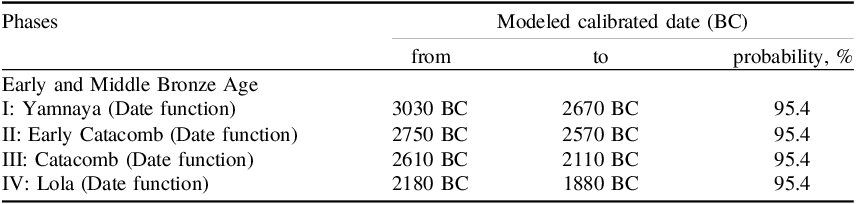
The constructed Bayesian model for the Early and Middle Bronze Age includes four cultural and chronological phases, and are shown in Table 2, Figures 4–5.
Early and Middle Bronze Age. Northern fringes of the Kuma-Manych Depression and the Sal steppes. Modeled calibrated date ranges for the cultural and chronological phases.

Early and the Middle Bronze Age. Results of the Bayesian modeling: Phase I – Yamnaya culture; Phase II – Early Catacomb culture.

Figure 4 Long description
Panel A: The graph displays Bayesian modeling results for the Yamnaya culture during Phase I. The x-axis represents the modeled date in B C, ranging from 3300 to 2400 B C. The y-axis lists various radiocarbon dates and combined dates. Each data point is represented by a probability distribution curve, indicating the likelihood of the modeled date. The graph includes multiple overlapping curves, showing the range and uncertainty of the radiocarbon dates. Panel B: The graph shows Bayesian modeling results for the Early Catacomb culture during Phase II. The x-axis represents the modeled date in B C, ranging from 3400 to 2000 B C. The y-axis lists various radiocarbon dates and combined dates. Each data point is represented by a probability distribution curve, indicating the likelihood of the modeled date. The graph includes multiple overlapping curves, showing the range and uncertainty of the radiocarbon dates.
Early and the Middle Bronze Age. Results of the Bayesian modeling: Phase III – Catacomb culture culture; Phase IV – Lola culture.

Phase I: Yamnaya. We dated ungulate bones from the lower occupation layers at two campsites from Temrta-1 (Sal steppes) and Chikalda-7 (Kuma-Manych Depression). The obtained data agree with 19 dates for six burial grounds, i.e. Ulan IV (Kuma-Manych Depression) and Temrta IV, Sukhaya Termista I and Sukhaya Termista II, Peschany IV and Peschany V (Sal steppes). The calibrated range of phase I is 3030–2670 BC (95.4% probability) (Figure 4).
Phase II: Early Catacomb. The chronological range of this phase is based only on the dates obtained for eight samples from the burials. As of today, no campsites containing diagnostic items characteristic of this culture have been found. One date was obtained for Ulan IV in the Kuma-Manych Depression, seven dates were obtained for samples from five burial grounds located in the Sal steppes, i.e. Sukhaya Termista II, Temrta I and Temrta V, Peschany IV and Peschany V. The calibrated range of phase II is 2750–2570 BC (95.4% probability) (Figure 4).
Phase III: Catacomb combines the Western Manych and the Eastern Manych cultures. Five dates were produced for the lower and middle layers at the campsites in the Kuma-Manych Depression, i.e. Chikalda-1, Chikalda-6 and Chikalda-7, and Volochaika-4; 22 dates were produced for 18 burials at five burial grounds, with two dates produced for Ulan IV (Kuma-Manych Depression) and all other dates produced for Peschany IV and Peschany V, Temrta I and Temrta V (Sal steppes). The calibrated range of phase III is 2610–2110 BC (95.4% probability) (Figure 5).
Phase IV: The Lola culture chronological range is based on the dates obtained for one sheep and two human bones from the graves. The calibrated range of phase IV is 2180–1880 BC (95.4% probability) (Figure 5).
The constructed Bayesian model for the Early Iron Age includes two cultural and chronological phases (Table 3, Figure 6).
Early Iron Age. Northern part of the Kuma-Manych Depression and Sal steppes. Modeled calibrated date ranges for the cultural and chronological phases.

Early Iron Age. Results of the Bayesian modeling.

Figure 6 Long description
Panel A: A line graph showing the modeled dates for the Scythians phase 1. The horizontal axis represents the modeled date in B C and A D, while the vertical axis represents the sequence index age. Multiple data lines are labeled with different identifiers such as R_Combine, R_Date, and Date Scythians, showing various trends and patterns. Panel B: Another line graph depicting the modeled dates for the Sarmatians phase 2. The horizontal axis represents the modeled date in B C and A D, while the vertical axis represents the sequence index age. Multiple data lines are labeled with different identifiers such as R_Date, R_Combine, and Date Sarmatians, showing various trends and patterns.
Phase I: Scythian. This phase is based on the dates produced for a cattle bone from the upper layer at Bolshaya Elista-1, a horse bone from Ulan-4 (Sal river basin) and three dates from two burials at Temrta I and Peschany IV in the Sal river basin. The calibrated range of phase I is 680–190 BC (95.4% probability) (Figure 6).
Phase II: Sarmatian. This phase is based on radiocarbon age of three ungulate bones from Tseketa-3 (Sal river basin) and Keresta-5 (Manych river basin) seasonal campsites and five dates for the samples obtained for two burials at Peschany IV and Nemashkalovo (Sal river basin). The calibrated range of phase II is 300 BC–490 AD (95.4% probability) (Figure 6).
Chronological intervals for local cultural groups
For the Eneolithic culture, the radiocarbon dates obtained for wild horse and ungulate bone samples from the lower occupation layers of the seasonal campsites (Volochaika-4 and Chikalda-6; Kuma-Manych Depression; Bolshaya Elista-1, Sal steppes) agree with the 14С dates for four burials at four burial grounds, namely, Ulan IV (Kuma-Manych Depression) and Peschany IV and Peschany V, and Sukhaya Termista I (Sal steppes). The earliest date comes from the Bolshaya Elista-1 seasonal campsite (horse bone), the latest from the Peschany IV burial ground (saiga bone). The median interval for the Eneolithic period is 4100–3450 calBC (Supplementary file 2).
There are no sufficient archaeological data available for the Late Bronze Age. This period is represented in a very fragmented way by secondary burials from the Early and Bronze Age mounds. These burials had no funerary offerings. One date obtained for an ungulate animal bone from the Temrta-1 campsite (Sal steppes) is evidence for a short-term occupation of this campsite located in the Sal steppes by a population group in the period 1496–1426 calBC (68.3% probability) or 1500–1496 calBC (95.4% probability). One secondary burial made in the Yamnaya kurgan at the Ulan IV burial ground (northern area of the Kuma-Manych Depression) dates back to 1113–1006 calBC (68.3% probability) or 1190–930 calBC (95.4% probability), which is the transition from the Late Bronze Age to the Early Iron Age in the study region.
The Migration period of the early Middle Ages was singled out based only on one date produced for an ungulate bone retrieved from test trench 3 at the Temrta-1 seasonal campsite (Sal steppes). The calibrated range is 435–537 AD (68.3% probability) or 425–545 AD (95.4% probability).
The medieval Khazar Khaganate period was determined based on two dates from two layers at the Temrta-5 seasonal campsite (Sal steppe). The time interval for the Khazar Khaganate period is 734–815 calAD (95.4% probability).
The medieval Golden Horde period was singled out using samples from burials at one burial ground in the Kuma-Manych Depression (Ulan IV) and three burial grounds in the Sal steppes (Peschany I, Peschany IV, and Balka Bolshaya Elista). The time interval for this period is 1252–1346 calAD (95.4% probability).
Discussion
Local chronology
We used the AMS 14C dating results as well as Bayesian modeling obtained for Early and Middle Bronze Age cultures to derive a revised chronological framework for one of key historical sub-regions in the Lower Don, i.e. the Sal steppes and the northern fringes of the Kuma-Manych Depression. Our radiocarbon dates cover the period from the Eneolithic (5th millennium BC) to the Mongol invasion of eastern Europe and emergence of the Golden Horde (13th–14th centuries).
Using this new and more precise chronology for these sub-regions, we can estimate continuity and discontinuity of the periods when various population groups began to settle down and subsequently exploit these important sub-regions of the Lower Don. In addition, we can also check a priory assumption regarding temporal gaps in the chronology, eliminate some of these gaps using new archaeological records and discuss coexistence of several cultures in the Sal steppes and the Kuma-Manych Depression.
The initial period of this region exploitation is linked to the Eneolithic population that began to use the balka systems of the Sal and the Manych rivers starting from the last quarter of the fifth millennium BC. The AMS 14C dates for the samples from both campsites and primary burials of the earliest kurgans in this region that fall within time period of 4100–3450 calBC which was 600 years long, suggesting that it was a slow and gradual process. The stratigraphy of the earliest kurgans and destruction of primary Eneolithic burials (Peschany V, kurgan 15, Sal basin; Ulan IV, kurgan 3, Manych basin) by Yamnaya burials made in these kurgans in the subsequent periods do not enable us to argue that the Eneolithic and the early Yamnaya groups could coexist in the study region. We observe a short chronological gap between the earlier data obtained for the animal bone from the lower layer at the Temrta-1 campsite that contained diagnostic fragments of the Yamnaya ceramics (IGANams-8330, the median date is 3079 calBC) and the latest Eneolithic date for the saiga bone from Peschany IV, kurgan 23, grave 2 (D-AMS 052955, the median date is 3450 calBC). This suggests that at the very end of the fourth millennium BC new Yamnaya groups arrived in the Sal steppes and the northern fringes of the Kuma-Manych Depression which was sparsely populated. Rare and very small groups may have visited or lived in this area during the Late Eneolithic.
Additional data are needed to confirm or reject this statement. The Bayesian model was used to date four chronological phases for the Early and the Middle Bronze Age local cultures more precisely.
Phase I in our periodization (3030–2670 BC) is based on the AMS 14C dates obtained for the samples from the Yamnaya graves and seasonal campsites. Population groups were permanently settled in the Sal basin and the northern fringes of the Kuma-Manych steppes. Our work is the first to assign more precise dates to the local Yamnaya groups living in the Sal steppes and in the northern fringes of the Kuma-Manych Depression. The temporal range shows that the Early Yamnaya groups did not settle in these sub-regions until 3000 BC and that the Yamnaya pastoralists began to exploit this area when they became a dominant population in a rather large area extending from the Urals to the western areas of the Black Sea region. Besides, the Yamnaya groups did not live in the Sal steppes and the northern fringes of the Kuma-Manych Depression for a long time, though earlier studies suggested that they lived in this region until the end of the third millennium BC (Merpert Reference Merpert1974).
Archaeological records from the seasonal sub-regional sites do not make it possible to correlate any of these sites with the Early Catacomb groups. Our earlier analysis of the AMS 14C dates obtained only for seasonal campsites (Shishlina et al. Reference Shishlina, Leonova, Kalinin, Shishlina and Kazarnitsky2023a) showed that the analyzed chronology of the cultures in this region does not fit with the chronology of the Early Catacomb groups. However, eight AMS 14С dates for the samples from the burial context provide convincing evidence that, moving slowly from the Caspian Sea region and the Sea of Azov steppes (Shishlina Reference Shishlina2008), the Early Catacomb pastoral groups reached the Sal steppes and began exploiting its resources during phase II (2750–2570 BC). The analysis of the kurgan stratigraphy shows a chronological correlation between the two cultures. However, more precise temporal ranges for the chronological phases I and II make it possible to single out a short period of about 50–60 years of coexistence of the Yamnaya and the Early Catacomb populations.
Another and even shorter period when other cultures overlapped lasting about 30–40 years can be observed between the final period of the Early Catacomb culture and the emergence of the Western Manych and the Eastern Manych Catacomb groups in the region (chronological correlation between phases II and III). This period marks the start of the Middle Bronze Age and a long temporal range of the regional Bronze Age, which is phase III (2610–2100 BC) in our periodization. Thus, numerous kurgans, burials and campsites assigned to the Catacomb cultures reflect a high density of the population and, showing a peak in the development of the Catacomb cultures during the second half of the third millennium BC.
However, an environmental crisis (the so-called 4.2 ka event) that affected almost all regions in Europe and the Caucasus (Jalali and Sicre Reference Jalali and Sicre2019) and transformed the entire sub-regional cultural environment took place around 2200 calBC. This is the beginning of the final period of chronological phase IV (Lola culture) in our periodization, 2180–1880 calBC. The comparison of the intervals obtained for the Catacomb and Lola cultures suggests that these cultures coexisted in the studied region for approximately 80 years. The density of the population declined, the Catacomb groups disappeared. They probably migrated to areas in the Don estuary, the Sea of Azov steppes, and the Stavropol Hills which were better suited for life. Meanwhile, in the final period of the Middle Bronze Age during the transition from the third to the second millennia BC, a new culture emerged. This is known as the Lola culture whose origin can be linked to the regions located further south (Mimokhod Reference Mimokhod2018). Later these Lola population groups disappeared from the region as well.
It is not clear what population lived in the Sal steppes and in the north of the Kuma-Manych Depression in the second millennium BC. Archaeological data are extremely fragmented and not diagnostic. A hypothesis on a regional cultural “hiatus” in the Late Bronze Age has been proposed (Sinitsyn Reference Sinitsyn1978).
According to earlier accepted cultural chronologies (Sorokina Reference Sorokina and Munchaev1989), drastic climate change, cultural disruption and even discontinuity in the second millennium BC caused population groups to abandon many arid and semi-arid areas in the southern Russian Plain. Scholars thought that the arid areas of the Sal steppes and the northwestern Caspian region became depopulated, the cultural development of these sub-regions coming to a standstill. However, our new AMS 14C dates for the samples from the seasonal Temrta-1 campsite (Sal steppes) and a burial from the Ulan IV burial ground (Kuma-Manych Depression) provide evidence that some mobile pastoral groups (perhaps Kobyakovo or Cimmerians) reappeared in these areas during occasional migrations. One of the issues for the study sub-regions relating to this period is a lack of detailed analysis of the funerary rite and the chronological indicators for the final stage of the Late Bronze Age and the transition to the Early Iron Age which is traditionally dated at the end of the second–early first millennia BC (Bochkarev and Leskov Reference Bochkarev, Leskov and Basin1978; Ilyukov and Kazakova Reference Ilyukov and Kazakova1988; Sharafutdinova Reference Sharafutdinova and Basin1985). By adding substantially more archaeological and radiocarbon data, we will be able to better understand this period and possibly identify shorter periods linked to specific cultural groups.
The area occupied by the “typical” Scythians includes steppes and forest-steppes in eastern Europe as well as the Lower Don region (Alekseev Reference Alekseev2003). In the seventh to sixth centuries BC the presence of the early Scythians in the Sal steppes is attested by scarce graves of Scythian warriors that contain short iron swords known as akinakes, and quiver sets with bronze arrowheads typical for that period. Such items have been retrieved from the kurgans at Peschany IV; these are similar to those found in rich Scythian graves in the northern Black sea steppes (Romashko et al. Reference Romashko, Skory and Filimonov2014). However, most graves dating to the first half of the first millennium BC found in the Sal steppes and the Kuma-Manych Depression do not show any funerary offerings. Without diagnostic material such as coins, stamped ceramic vessels, Greek amphorae, and others it is extremely difficult to attribute such graves and kurgans to the Scythian period. There are very few 14C dates available for Early Iron Age graves. We obtained three AMS 14С dates for samples from the graves from two burial grounds and two dates from two campsites which introduce substantial corrections in the chronological sub-regional timeline under discussion. These new dates reveal that the Scythians who inhabited the study region moved from place to place from early 700 BC to the turn of the third century BC, when European Scythia that occupied a vast region extending from the Danube river in the west to the Don river in the east ceased to exist. Therefore, the groups ascribed to the Scythian “family” of cultures lived in the investigated region for approximately 330–350 years, probably until the turn of the third century BC when the Syrmatae, the Sarmatians and the Siraces arrived in the Lower Don and other regions (Alekseev Reference Alekseev2003). New data make it possible to select a period that lasted approximately 50–60 years when the groups of the Late Scythians and the Early Sarmatians probably coexisted.
The appearance of new nomadic groups marks a new period (300 BC–490 AD) that lasted for a rather long time. As has been noted earlier, the absence of the 14С dates for this period and subsequent periods made it difficult to verify the date of the final stage of the Iron Age and the date of the transition to the early Middle Ages. The results of the paired 14С dating from the same graves at Peschany IV (wood and human bone) and Nemashkalovo (human and sheep bones) rule out the existence of a reservoir effect in the human bone collagen. Also, the taxonomic affiliation of the wood to Elaeagnus which is a local and short-lived species excludes an old wood effect. The reliability of the date modeled for grave 1, kurgan 12, at Peschany IV (42 BC–25 AD) (68.3% probability) has been confirmed by a special type of western European fibulae used within a narrow chronological time span (10 BC–15 AD) from the same grave (Strokov et al. Reference Strokov, Shishlina and Leonova2022). The winter and summer seasons of the dated Tseketa-5 and Keresta-3 campsites provide evidence that the Sarmatian groups lived permanently in the Sal steppes.
From the context of the Migration period, not much is known. In the Lower Don nomadic sites of the Hun and post-Hun periods are scarce, while in the Sal steppes such sites are not known. Nevertheless, on the basis of so far only one date of an ungulate bone from the upper layers of the Temrta-1 campsite in the Sal steppes, we estimate that in the fifth century AD this area was visited by the nomads of the Migration period for short periods. This interval agrees with the new radiocarbon dates for the graves from the Migration period at the Borisovsky cemetery in Gelendzhik and at the Chufut-Kale cemetery in Crimea (Strokov et al. Reference Strokov, Gulyás, Somogyi and Kamelina2024). We can infer from this analysis, that in the middle to third quarter of the first millennium AD some mobile groups used the balka systems of the Sal river for their movements and short-term stays.
The following period lasted roughly for 100–150 years, and is characterized by a very low density of the population in the study region. There are no archaeological sites in the region that could be clearly ascribed to a specific cultural group. However, two AMS 14C dates for ungulate bones retrieved from the lower layers at Temrta-5 (Sal basin) correlate with the period of the Khazar Khaganate in the Volga-Don interfluve that also included the Sal steppes and the Kuma-Manych Depression. This location was regularly visited in the seventh-ninth centuries. At that time, the Sarkel Khazar fortress was built at a distance of approximately 200 km from Temrta-5 (Pletneva Reference Pletneva1996); graves of warriors dating to this period appeared in the steppe (Garmashov Reference Garmashov and Vlaskin2002; Rogudeev Reference Rogudeev and Gorbenko2010); and numerous Khazar seasonal campsites were built on the right bank of the Lower Don basin (Nechiporuk Reference Nechiporuk2025). The time interval obtained for the seasonal Khazar campsite, which is 734–815 calAD, correlates with the period of the Khazar Khaganate dominance in the Don steppes, the Black Sea region and the northern Caucasus.
Some scholars believe that in summer the Khazar groups used to move away from their permanent settlements located in the steppe northeastern Pryazovie region (Sea of Azov region), where more than 1000 Khazar sites have been found, to other areas including the Sarkel fortress (Grib Reference Grib2022; Grib et al. Reference Grib, Larenok and Zavershinskaya2024). More productive grasslands in this area were more attractive for the Khazar groups than arid dry steppes; for this reason, there are few Khazar materials found in the study region.
In 965 AD the Khazar Khaganate was destroyed by the troops of prince Sviatoslav I of Kiev, the Sarkel fortress was captured and the territory of the Khaganate was divided between Kievan Rus and nomadic populations of the Pechenegs and the Oghuz Turks. The Khazars of the Don region became subjects of the Tmutarakan principality which existed until the early 12th century (Pletneva Reference Pletneva1976).
The final period in the discussed chronology is represented by AMS 14С dates for a medieval Polovtsian burial (Peschany IV, kurgan 20, grave 3, the median date is 1227 AD) and Golden Horde burials. In 1237–1238 the Mongol army led by Batu Khan, son of Jochi, invaded Kievan Rus. Many Russian principalities were destroyed, and their cities were sacked and burned down. In the mid-summer of 1238 the Don steppes came under the control of Batu. By the middle of the 13th century Batu Khan established the Golden Horde, which was a Mongol khanate that later came under Turkish influence. Its vast territory included Kazakhstan, the Volga-Urals interfluve, the Volga region, the northern Caucasus and the Dniester region. This khanate had both steppe towns and several khan’s residence camps (Boldyreva Reference Boldyreva2024). Graves of warriors and nomadic elite began to appear in the Don region and other sub-regions. So far, in the absence of diagnostic archaeological material, it is difficult to link any of the campsites discovered in the Sal steppes to these groups; however, the presence of the Golden Horde nobility and warriors is attested by both new 14C dates as well as typical Mongol goods, such as elements of characteristic costume made of silk and cotton and weapons (Leonova et al. Reference Leonova, Shishlina, Loboda and Soloshenko2021). The AMS 14C dates obtained from these graves within the interval of 1252–1346 AD correlate with dates in written sources such as Russian chronicles (Kloss Reference Kloss1980).
Comparative analyses
We used the new local temporal range constructed for the Sal steppes and the northern fringes of the Kuma-Manych Depression to compare the temporal range of the discussed Eneolithic and Bronze Age cultures in this region with the cultures of the same period from the northwestern Caspian steppes (Figure 7). We identify variations in the cultural and chronological development of the two neighboring steppe regions.
Comparative analyses of the Eneolithic-Bronze Age chronological scheme proposed by Shishlina for the northwest Caspian steppes (2008) and the new Bronze Age scheme proposed in this paper for the Sal steppes and Kuma-Manych Depression sub-regions of the Lower Don.

The Eneolithic pastoral groups appeared in the Sal steppes and the northern fringes of the Kuma-Manych Depression around 4100 calBC and the Eneolithic period lasted for quite a long time. This is confirmed by the AMS 14C dates for the samples from both the Eneolithic burials and the Eneolithic seasonal campsites. There are no dated campsites of that period in the northwestern Caspian region, and the chronology of the Eneolithic period has been constructed using the radiocarbon dates for the samples selected only from the burials. The Eneolithic groups appeared in the northwestern Caspian region approximately 200 years earlier.
Throughout the fourth millennium BC, the northwestern Caspian region was marked by the presence of the Maikop population (3800–3500 BC) and the Late Maikop population (3400–3000 BC) separated from each other by a time gap (between 3500 and 3400 BC). Yamnaya kurgans have been observed in the final stage of the Late Maikop culture. However, the cultural and chronological contexts of this temporal framework need to be verified and complemented with additional data to check a likely reservoir effect on the 14C age of the Early Maikop individuals. In the study sub-regions of the Sal steppes and the northern fringes of the Kuma-Manych Depression, burials or seasonal campsites that could be ascribed to the Maikop culture have not been discovered. However, both Maikop burials containing ceramics, tools and weapons of the Maikop type and Maikop permanent settlements have been found in the areas further to the south in the Lower Don valley (Ilyukov and Larenok Reference Ilyukov and Larenok2025; Kiyashko Reference Kiyashko1994). Most likely, the Maikop groups did not venture deep into the dry areas of the Sal steppes.
On the whole, the Yamnaya phase (phase I) in the sub-regions of the Sal steppes and the northern fringes of the Kuma-Manych Depression was rather short. This temporal range has been constructed using a reliable suite of the AMS 14C dates on the samples from the Yamnaya burials and settlements. In the northwestern Caspian region, the Yamnaya period lasted longer. One possible explanation is that some Yamnaya groups stayed longer in the northwestern Caspian region, and that their stay overlapped with that of other cultural groups. The reverse stratigraphy of the kurgans suggests that the Late Yamnaya, North Caucasian and Early Catacomb graves were more or less contemporaneous. Such graves often contain similar items such as bone pins, vessels, jewelry made of metal and bone.
The Early Catacomb phase (phase II) in the sub-regions of the Sal steppes and the northern fringes of the Kuma-Manych Depression is contemporaneous with the polycultural horizon of the northwestern Caspian region. In this period the Early Catacomb, Late Yamnaya groups, groups of the North Caucasus culture and a special type of a polycultural group inhabited the same area. The sub-regions of the Sal steppes and the northern fringes of the Kuma-Manych Depression did not show such a mosaic of cultures, the burials of the North Caucasus culture are few in number and there are no Yamnaya/Catacomb and polyritual groups there. Approximately 2600 calBC the Early Catacomb groups were succeeded by other cultures attributed to the “family” of the Catacomb cultures, which in turn were succeeded by the Lola culture at the end of 3000 BC. The Catacomb and Lola groups coexisted for approximately 80 years. Throughout the entire second half of the third millennium BC the northwestern Caspian region was inhabited by the Eastern Manych Catacomb population. The Sal steppes were home for predominantly Western Manych Catacomb populations, and Eastern Manych Catacomb burials in the Sal steppes are scarce. In both sub-regions the Lola culture was the last cultural group of the Middle Bronze Age final period; this group has not been included in our analysis of the Eneolithic–Bronze Age in the northwestern Caspian region (Shishlina Reference Shishlina2008). However, the new AMS 14С dates on the samples from the Lola burials confirm that the Lola population emerged in the Caspian steppes, Kuma-Manych depression and the Sal steppes practically at the same time during the transition from the third to the second millennia BC (Shishlina Reference Shishlina2013). It should be noted though that our radiocarbon dataset for the northwestern Caspian region needs to be enlarged in order to construct more reliable temporal ranges for the cultures and cultural groups identified.
So far, to conduct this comparative analysis is possible only for the Eneolithic–Bronze Age cultures in the northwestern Caspian region and the Sal steppes and the Kuma-Manych Depression because a large dataset of radiocarbon dates has been put together only for these two regions.
Conclusion
A total of 86 AMS 14C dates for the samples associated with burials and seasonal campsites of various cultures and Bayesian modeling for the Early and Middle Bronze Age periods based on 56 AMS 14C dates and Early Iron Age periods based on 12 AMS 14C dates are used to establish a revised chronological framework for the Sal steppes and northern fringes of the Kuma-Manych Depression which is a sub-regions of the Lower Don in the south of the Russian Plain. Not all analyzed archaeological sites, e.g. kurgans, burials and seasonal campsites, have clear diagnostic material, i.e. objects of the material culture with a known period of use. Early Eneolithic and Yamnaya burials frequently show similar features of the funerary rite, making it difficult to assign them to a specific culture. No data are available for some historical and chronological periods for the region investigated. The new chronological framework has made it possible to eliminate existing time gaps and refine or extend chronological periods. Short overlapping periods when some sub-regional groups coexisted are identified.
This framework covers a period of several millennia, from the fifth millennium BC to the middle of the second millennium AD. In this period the steppes and the arid steppe regions of the Lower Don saw the emergence, development and spread of a specific form of producing economy known as mobile pastoralism. Throughout several millennia mobile herding was the main occupation of the local population. The new constructed absolute chronology which is more robust shows that during the Eneolithic (4100–3450 calBC), a group of pastoralists penetrated in the open steppe areas. This process was very slow and gradual. The development of a new economic pastoral model within the exploited region is linked to the Yamnaya population (phase I: 3030–2670 BC). During the final period of this phase the Yamnaya population coexisted with newcomers, i.e. the Early Catacomb groups. An earlier analysis of kurgan stratigraphy has failed to identify this overlap whereas the chronology based on Bayesian modeling (phase I: 3030–2670 BC; phase II: 2750–2570 BC; phase III: 2610–2100 BC, and phase IV: 2100–1880 BC) clearly shows that during a short period the Yamnaya population and the Early Catacomb groups lived side by side. The first “overlap” period was followed by a shorter period when the Early Catacomb population coexisted with the population groups of the Western Manych and the Eastern Manych Catacomb cultures. The subsequent overlap period is associated with the coexistence of later local Catacomb groups and the non-local Lola group, linked to the “4.2 ka event” that triggered transformation of the local cultural landscape and, most likely, abandonment of the area that became unsuitable for successful mobile herding.
Based on the new AMS 14C dates, however, we can argue that some population groups lived in this region for a short period of time in the middle of the second millennium BC (Late Bronze Age), during the final stage of the Late Bronze Age at the end of the second millennium BC (possibly Kobyakovo culture or Cimmerians) and in the period between the early eighth century BC to the sixth century BC (early Scythians). Thus far the chronological boundaries of the Scythian period (680–180 BC) were not secure, whereas the cultural and chronological contexts of the Late Bronze Age had not been described or discussed. The AMS 14С dates for the Sarmatian burials and campsites clearly define the temporal range limits of the distribution of the Sarmatian groups in the Sal steppes and the northern fringes of the Kuma-Manych Depression (300 BC–490 AD). Our study is also the first to produce precise AMS 14C dates for the Migration period (500 calAD), the Khazar Khaganate period (735–815 calAD) as well as the period when the Golden Horde khanate was set up and developed (1252–1346 calAD). These dates are in good agreement with what is known from written sources.
The comparative analysis of the chronology of the Eneolithic–Middle Bronze Age cultures of the Sal steppes and the northern fringes of the Kuma-Manych Depression and the chronological framework that covers the Eneolithic–Middle Bronze Age derived for the northwestern Caspian region based on the conventional and AMS 14C dates reveals important regional differences. The Eneolithic period in the northwestern Caspian region was shorter; starting from the second quarter of the fourth millennium BC, small Maikop and Late Maikop groups visited this region pushed by migration processes unfolding in the northern Caucasus region. They began to exploit the fertile Don estuary and did not venture to stay in the inhospitable Sal steppes. The Yamnaya population of the northwestern Caspian region and the population of the Sal steppes and the Kuma-Manych Depression were contemporaneous. This reflects a rapid dissemination of this population across the vast eastern European region and beyond, as they moved eastward to the Urals and westward to western Europe in 3000–2800 BC. However, a later upper chronological boundary of the Yamnaya population in the northwestern Caspian region can be explained by an inadequate number of more precise AMS 14C dates as well as by differences in the cultural development compared to the Yamnaya in the Sal and northern fringes of the Kuma-Manych sub-regions characterized by coexistence of numerous cultural groups in the period between 2600 and 2300 BC. This conclusion is confirmed not only by a series of dates but also by examples of reverse stratigraphy (Shishlina Reference Shishlina2008). We conclude that earlier appearance of the Early Catacomb groups in the Sal steppes has been confirmed by more precise AMS 14C dates. The Western Manych and Eastern Manych Catacomb groups in the two regions are contemporaneous and are succeeded by the Lola groups, with which they overlapped during the final stage of their life.
The results of Bayesian modeling and comparative cultural and chronological analysis of two neighboring sub-regions of the Russian Plain emphasize the importance of consistent quality radiocarbon dating. Such a program can pursue various goals, such as addressing issues of chronology related to specific sites or cultures, constructing periodization of historical periods or creating wider regional chronologies.
An increased number of the AMS 14C dates for samples from short-term campsites and stratified kurgans will help clarify chronological boundaries of the regional cultures discussed as well as perform a comparative analysis of these data and similar data from neighboring regions, for example, the Stavropol, Kuban and Volga regions.
Supplementary material
To view supplementary material for this article, please visit https://doi.org/10.1017/RDC.2026.10215
Acknowledgments
This work has been supported by the Russian Scientific Fund, grant No 25-18-00028.