1. INTRODUCTION
In 2002, a group of scientists of the Chinese Academy of Sciences (CAS) presented a new concept of navigation, i.e., transmitting satellite navigation system (Ai, et al., Reference Ai, Shi, Wu, Yan, Bian, Hu, Li, Guo and Cai2004). They suggested the use of GEO commercial communication satellites and the launch of a certain number of inclined geosynchronous orbit (IGSO) satellites to constitute a navigation constellation, plus the use of satellite transponders to transmit signals of the atomic clock and navigation messages from the ground station, to enable users to receive navigation signals to solve the pseudo-range observation equations and enjoy the services like navigation and positioning, measurement of velocity and time (Ai, et al., Reference Ai, Shi, Wu, Yan, Bian, Hu, Li, Guo and Cai2008; Ai, et al., Reference Ai, Shi, Wu, Li and Guo2009; Han, et al., Reference Han, Ma, Qiao, Yin and Ai2009). Unlike the direct broadcasting satellite navigation system which includes the American Global Positioning System (GPS), the Russian GLONASS, the European Galileo and the Chinese Compass satellite navigation system (Compass), the transmitting satellite navigation system being developed in China uses transponders onboard communication satellites to transmit navigation message and ranging signals to users. Its navigation and ranging signals are generated at a ground station instead of onboard satellites. Therefore, different inclinations of inclined geosynchronous orbit (IGSO) satellite are considered in the transmitting navigation system. In the China's 2nd generation satellite navigation system, the constellation framework of the transmitting satellite navigation system is composed of two geostationary orbit (GEO) communication satellites, four slightly inclined geostationary orbit (SIGSO) satellites and one highly IGSO satellite. Considering China's mainland coverage in the northern hemisphere, the latitude of the most southerly station that can uplink navigation signals is about 18°N when the IGSO satellite travels to the southern hemisphere. Meanwhile, as China's longitude covers approximately 62°, the inclination of the IGSO satellites cannot be too high, or its signals would not be received by the users in the middle and high latitude areas when the IGSO satellite moves to the southern hemisphere. The ground master station cannot uplink high-quality navigation signals as well. In this work, navigation performance in terms of availability of the IGSO satellite with different inclinations is examined when navigation signals are uplinked from the ground stations Lintong and Sanya respectively.
2. NAVIGATION SIGNAL UPLINKS FROM LINTONG
2.1. Uplinking navigation signal
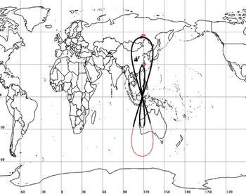
In the transmitting satellite navigation system, the ground uplink station determines and predicts communication satellites’ orbits, measures and computes signal transmitting time from the satellite, adjusts downlink signal of the satellite to some given frequency, generates and uplinks the navigation signal to transponders onboard the satellite. The user receiver in the footprint can calculate its position, velocity, and time. It is known that a signal from a satellite with a lower elevation angle results in remarkable attenuation when the propagation wave passes through the atmosphere. Therefore a high elevation angle is required when uplinking signals from a ground station (Cui, et al., Reference Cui, Shi, Chen and Pei2009; Ma, Reference Ma2011). Generally the elevation mask angle from ground station to satellite of more than 20° can guarantee high-quality navigation signals. In the transmitting satellite navigation system, Lintong in Shangxi province is regarded as a navigation ground station and ground tracks in a day are shown in Figure 1. The inclination angles examined for the IGSO satellite are 28·5° and 55° respectively.
Ground track of IGSO with 28·5° and 55° inclination.

It is obvious that the preferable uplinking period is longer when a small inclination is adopted by the IGSO satellite. Table 1 compares the time periods of uplinking signals over 24 hours (86 400 seconds), when the inclination of the IGSO satellite take values of 28·5° and 55° respectively.
Uplink period of time for different IGSO inclinations.

Compared with the 55° inclination, the 28·5° inclination brings an increase of 21·9% uplink time. This means that the availability of IGSO satellite increases 21·8%. Therefore, in order to increase the available uplink time period, a lower IGSO inclination in the transmitting satellite navigation system should be taken.
2.2. Navigation performance
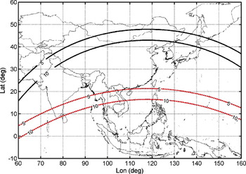
When the IGSO satellite moves to the southern hemisphere, the signal footprint area remains large if the inclination angle is small. This compares to the footprint of a geostationary satellite with zero inclination where the signal coverage is the largest. When the IGSO satellite travels over the southern hemisphere, the IGSO with the inclination angle of 28·5° can be observed by most of the China. With inclination of 55°, only stations in the southern area of the Hainan Island can receive signals when the elevation mask angle is set 5°. This is shown in Figure 2.
Ground cover distribution when the IGSO satellite moves about its most southerly position. The black and red lines correspond to IGSO satellite inclination angle of 28·5° and 55° respectively, with elevation mask angles of 5° and 10°.

Generally the Positional Dilution of Precision (PDOP) can be used to evaluate the merits of space constellation configuration. The position error is the product of PDOP and pseudo-range measurement errors (Kaplan and Hegarty, Reference Kaplan and Hegarty2006). In the constellation framework with six GEO satellites and one IGSO satellite, if the ground station does not uplink navigation signals to the IGSO satellite, the IGSO satellite cannot function; meanwhile when the IGSO satellite orbits near to the equatorial plane, IGSO satellite is only equivalent to a GEO satellite. Navigation constellation with only GEO satellites, the PDOP value exceeds 10 000, and user receiver cannot achieve navigation.
Actually, in the transmitting satellite navigation system when the IGSO satellite fails to play an important role, the system can take advantage of two GEO satellites and four SIGSO satellites to provide navigation services over the most territory of China, except for some areas in the eastern Heilongjiang Province. Though variation of PDOP values in the coverage area can be several tens, and user can still obtain navigation and positioning solutions. Navigation performance of the transmitting navigation constellation is analysed with daily PDOP variations in the following.
2.2.1. Daily PDOP variations in some stations
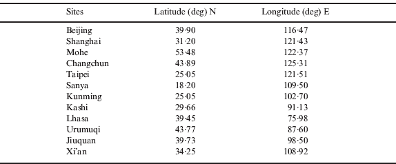
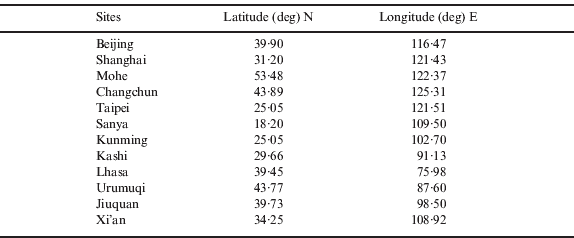
At present, the navigation constellation for the transmitting satellite navigation system consists of two GEO satellites (87·5°E and 110·5°E), four SIGSO satellites (51·5°E, 71·7°E, 130°E and 163°E) with inclination angle of 3° and one IGSO satellite (118°E). Sites located in Beijing, Shanghai, Mohe, Changchun, Taipei, Sanya, Kunming, Lasa, Kashi, Urumqi, Jiuquan and Xi'an are selected to analyse the daily PDOP changes, which are shown in Table 2. Ignoring effects of GEO satellite manoeuvres, daily PDOP changes for the 12 stations are calculated with four satellites chosen from all visible satellites based on the minimum PDOP values.
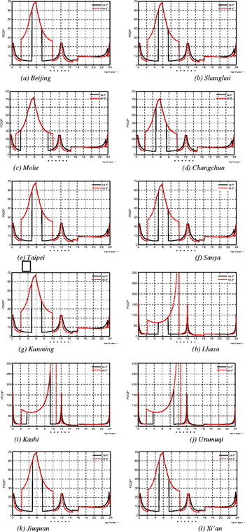
The maximum, minimum and average values of PDOP for the 12 stations are shown given for the elevation mask angles of 5° and 10° in Table 3 respectively, where the calculations of average PDOP values exclude the PDOP larger than 1000. As it can be seen, when the IGSO satellite is above southern hemisphere with inclination of 55°, there is a time of about 0·5 hours over which the PDOP values exceed 1000 at both Kashi and Urumqi station.
Locations of the 12 stations in China.
Statistics of daily maximum, minimum and mean PDOP values for 12 stations.

Figure 4 shows the daily PDOP values for each of the 12 stations when the elevation mask angle for signal uplink from the main ground station is 20° and elevation mask angle determining satellites visibility for user's terminal is 10°.
Daily PDOP variations of 12 stations.

Table 4 gives the average time period with PDOP less than 6 from all the 12 stations, when the inclination of the IGSO satellite takes 28·5° and 55·0° respectively.
Period time for PDOP⩽6 for 12 stations.

When the elevation mask angle for the navigation signal uplink from the Lintong station is 5°, the daily mean PDOP values for the 12 stations are 15·48 and 24·60 corresponding to the 28·5° and 55° inclination angles of the IGSO satellite. When elevation mask angle for navigation signal uplink is 10°, the daily mean PDOP value for the 12 stations reaches 17·97 and 27·67 corresponding to the 28·5° and 55° inclination of IGSO satellite. From the calculation of average time period when the PDOP value less than 6 for all the 12 stations, the interval of inclination 28·5° is 1·1 and 1·7 hours longer than that of 55° with the elevation mark angle is 5° and 10° respectively. Therefore, the 28·5° inclination is obviously superior to the 55° inclination for the IGSO satellite in terms of user PDOP performance.
2.2.2. Analysis of PDOP coverage
In order to comprehensively analyse of the PDOP distribution in various areas, the minimum, maximum and average PDOP values over 24-hour are calculated at grid points by latitude and longitude over the coverage area.
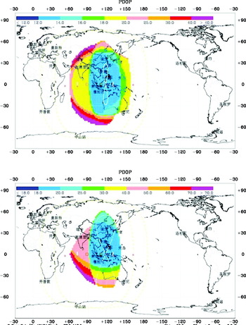
For simplicity, the inclination angle of all the SIGSO satellites is set 3°. Figure 4 shows the regional distribution of daily mean PDOP with the high IGSO satellite inclination of 28·5° and 55° respectively, where the elevation mask angle for the navigation signal uplink from the main ground station is 20° and the elevation mask angle determining the visibility of satellite at user's terminals is 10°. Only the PDOP values below 1000 at each grid are effectively considered in the computing.
Daily mean PDOP distribution within cover region. Top 28·5° inclination; Bottom 55° inclination.

From the above figures, daily mean PDOP between 13 and 18 can be achieved in the most of eastern China with the IGSO satellite inclination of 28·5°. The daily mean PDOP is slightly larger in north of Heilongjiang province, with 18–25; and 18–20 in Tibet, and in Xinjiang ranges between 18 and 40. When the IGSO satellite inclination takes 55°, in most of Xinjiang areas PDOP exceeds 1000 during the whole 24 hours, some regions in Tibet have shown PDOP values between 40 and 50 and daily mean PDOP of the rest most covered areas is between 18–25.
Overall, according to the daily PDOP change at the selected locations and the regional coverage of PDOP, the 28·5° inclination is obviously a choice superior to the 55° inclination for the IGSO satellite. In other words, a smaller IGSO inclination leads to better navigation performance than a larger inclination in the transmitting satellite navigation system.
2.3. Availability of IGSO satellite
When the IGSO satellite moves to the southern hemisphere, IGSO satellite is not available at this time if ground master station cannot uplink high-performance navigation signals or users at high latitudes in China are not able to receive the satellite signals for a period of time. In order to comprehensively investigate the IGSO satellite's function in the transmitting satellite navigation constellation, the availability of the IGSO satellite in the above 12 stations is calculated. Here we focus on percentage of unavailability time period of the IGSO satellite in a whole day for each station. The availabilities for the 12 stations are averaged and listed in Table 5. The 28·5° inclination for the IGSO satellite increases availability by 29·1% more than with an inclination of 55°.
Available mean percentage of 12 stations.

3. NAVIGATION SIGNAL UPLINKS FROM SANYA
The analysis in Section 2 is used to study the system navigation performance and availability of the IGSO satellite with different inclination angles when Sanya of Hainan province is taken as the navigation signal uplink station.
The results showed that the uplink station in Sanya can increase the available time period of the IGSO satellites about 10% than that in Lintong and the rate of increase could be 28·7% when considering elevation angle restrictions of navigation signal uplink station and user's terminal. When the elevation mask angle for the visible satellite is 5°, daily mean PDOP over the 12 stations is 8·55 and 16·01 with the IGSO inclination of 28·5° and 55°, respectively. When the elevation mask angle for visible satellite is 10°, daily mean PDOP for the 12 stations is 10·21 and 17·05 with IGSO inclination of 28·5° and 55°. In terms of the mean time intervals when PDOP lower than 6 for the 12 stations, compared to 55° inclination, IGSO with 28·5° inclination has an extra 1·9 and 1·5 hours with the elevation mask angles 5° and 10° respectively. Therefore, 28·5° is obviously superior to 55° for IGSO satellite inclination. Further, with the elevation mask angle 10°, when IGSO inclination is 28·5°, daily mean PDOP of 6–8 can be achieved in most regions with latitude lower than 40°N in China and a slightly higher daily mean PDOP in regions with latitude greater than 40°N (daily mean PDOP is nearly 20 in Northern Xinjiang and parts of northern Heilongjiang). When the IGSO inclination is 55°, daily mean PDOP is between 20 and 25 in Northern Xinjiang and 13 and 20 in the other areas. At this point, 28·5° is obviously superior to 55° for the IGSO satellite inclination.
4. CONCLUSIONS
Considering the facts that China's mainland coverage in the northern hemisphere crosses 62° in longitude and the southernmost station suitable to uplink navigation signal is 18°N latitude, the inclination of the IGSO satellites cannot be too high, or its signals cannot be received by the users in the middle and high latitude areas when the IGSO travels over the southern hemisphere. Therefore, the launched satellite not only has to provide the system with high-quality uplink navigation signals but also should give consideration to the user positioning performance in the high latitude areas in northern China. This raises new requirements for a balanced design and integrated optimization of satellite inclination. Analysis shows that the IGSO satellite with a smaller orbital inclination in the transmitting satellite navigation constellation can provide a better PDOP for most regions of China. Specifically, the 28·5° inclination is obviously superior to the 55° inclination for the IGSO satellite. In addition, navigation signal uplink stations in southern China (such as Sanya) can improve availability of the IGSO satellite and navigation performance in the transmitting satellite navigation system.
ACKNOWLEDGEMENTS
The authors wish to thank Prof Yanming Feng of Queensland University of Technology for help in improving English. Authors are grateful for the reviewers whose comments have largely contributed to the improvement of the manuscript. The work was carried out under the support of the National Basic Research and Development Program of China (Grant No. 2007CB815501) and the Young Researcher Grant of National Astronomical Observatories, Chinese Academy of Sciences.