


Introduction: Nubia as a cultural crucible
Nubia, south of Egypt, has witnessed continuous cultural change from prehistory to the present. The terms Lower and Upper Nubia are used here as broad cultural-geographical designations whose extent varied over time. In this perspective, the Third Nile Cataract formed a key transitional zone between northern regions often subject to Egyptian control and more southerly areas (Edwards et al. Reference Edwards2012).
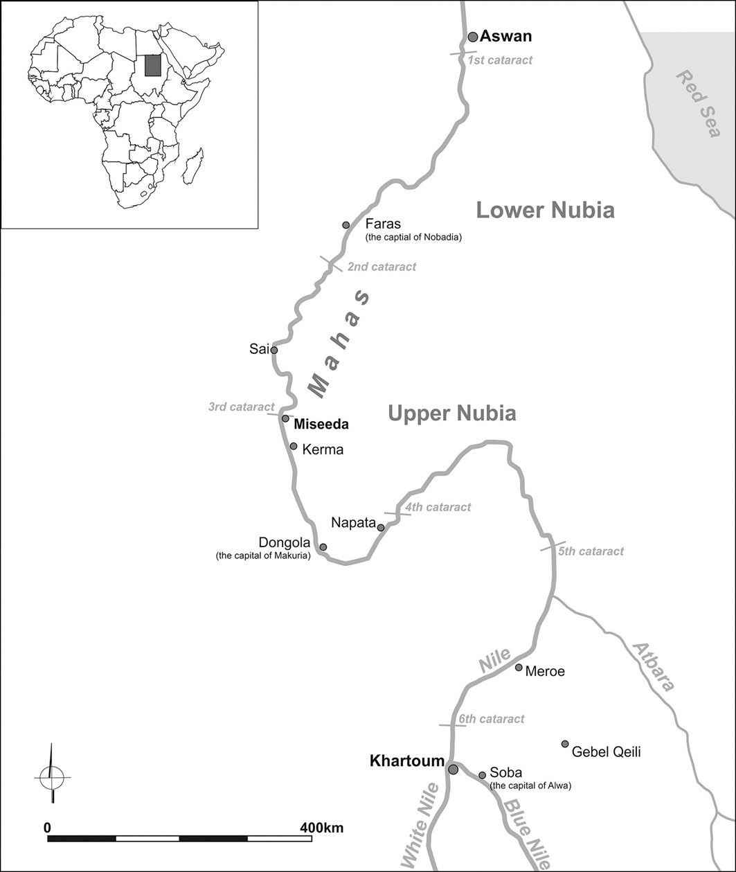
Building on earlier research by the University of Khartoum (Osman & Edwards Reference Osman and Edwards2011; Edwards et al. Reference Edwards2012), we conducted an archaeological survey in the Miseeda area, part of the Mahas region (Drzewiecki et al. Reference Drzewiecki2023) (Figure 1). Nearly 300 sites were recorded, including church MAS.021, built around a much earlier petroglyph (Figures 2 & 3). The project integrates archaeological survey, rock-art analysis, ethnographic fieldwork and geographic information systems-based spatial analysis to reconstruct the diachronic development of this sacred landscape and reassess the petroglyph within the frontier dynamics of the Third Cataract.
Map of the Nubia region showing the locations of the sites and regions mentioned in the text (© D. Zielińska).

The church of Miseeda with the petroglyph visible on the rock behind it (© S. Lenarczyk).

The petroglyph, possibly depicting a Kushite ruler (image enhanced; © C. Calaforra-Rzepka).

Dynamics of settlement: ebbs and flows
Preliminary results indicate peak activity during the Mesolithic (12 000–8200 years ago), the Late Neolithic/Pre-Kerma (c. 3000–2500 BCE; Osman & Edwards Reference Osman and Edwards2011: 46) and the Christian period (c. sixth–fifteenth centuries CE). Material from the Classic Kerma to Kushite periods (c. 1700 BCE–350 CE) is comparatively scarce (Figure 4).
Map of the project concession showing the distribution of recorded sites by period (© Mariusz Drzewiecki).

The analysis of pottery from the Mahas region reveals a complex pattern of local and regional production, alongside influences from more distant areas that shaped ceramic styles (Figure 5). Mesolithic pottery in this region reflects local traditions characterised by mineral-tempered fabrics. During the Pre-Kerma and Kerma periods, pottery exhibits elements characteristic of both northern and southern traditions, reflecting the borderland character of the Mahas region. The absence of Classic Kerma forms likely reflects the fact that the materials derive predominantly from settlements rather than burial sites. The Kushite period (c. ninth century BCE–fourth century CE) is poorly represented, with sparse pottery and lithic evidence, yet it produced one particularly important monument: a life-size petroglyph possibly depicting a Nubian ruler (Figure 3).
Selected pottery fragments from sites recorded during the survey (© K. Rosa).

The petroglyph and its iconographic context
Previous studies have suggested a Kerma, or more broadly a Kushite, date for the petroglyph in church MAS.021 (Osman & Edwards Reference Osman and Edwards2011: 66, 328; Edwards et al. Reference Edwards2012). Such monumental representations are rare, one being the carving of the Meroitic king Sherkarer at Gebel Qeili (Hintze Reference Hintze1959: fig. 2), which is interpreted as a manifestation of Meroitic rule over the southern fringes of the kingdom. This reinforces the interpretation of the Miseeda representation as a marker of a borderland; however, a more precise date remains to be established.
The granitic hill, featuring the petroglyph and the church, also preserves additional rock art, including large-scale depictions of a lion, a possible rhinoceros and an elephant, as well as smaller images of cattle. A broader survey conducted around the church revealed further iconography: Christian-period petroglyphs depicting crosses and ships, a variety of anthropomorphic figures of uncertain chronology and additional Kerma-horizon zoomorphs. These findings confirm the dynamic and continuous use of this rugged landscape across different historical periods (Polkowski Reference Polkowski and Claesin press).
The medieval period and Christian Nubia
The church at Miseeda, erected in the seventh century around the much older petroglyph, appears to have developed around a site that had retained social significance over millennia. It seems to have become the centre of a local sacred landscape, as suggested by the multitude of rock carvings in the vicinity that evoke Christian iconography—some of which clearly point towards the church itself. The Christian-period pottery assemblage from Miseeda comprises beakers characteristic of the dawn of the Kingdom of Nobadia alongside early wares in the style of the workshops of the Kingdom of Makuria at Dongola (late fifth–seventh centuries CE).
Local community, archaeological remains and ethnographic research
The project sets no chronological limits, encompassing evidence from the earliest traces of human activity to modern times. Parallel to the archaeological work, ethnographic research focuses on the interplay between local archaeological sites, the customs and beliefs of local communities, and borderland phenomena. In modern oral folklore, the rock art, the church and the ruins of post-medieval Diffi Allirki fortress (see also Osman & Edwards Reference Osman and Edwards2011), as well as multiple aquatic sanctuaries (water-associated ritual locations embedded in local cosmology and oral tradition) form the sacred landscape of the Miseeda region. These well-known yet secluded sites are linked to gold, spirits and mythical places, reflecting binary myth-making themes. The fortress and church MAS.021 are seen as both cursed and miraculous spaces, once used for pilgrimages and ritual offerings. Today, their sanctity is fading; the church is known instead as ‘Beit Kitchiner’ or ‘Beit Sheitan’, echoing changing local perceptions. Meanwhile, the shrine of Sheikh Kuman within the Miseeda village (Figure 6) has become the main sacred site, blending beliefs in water symbolism, mythical beings and Sufism.
An aquatic sanctuary attributed to the mysterious Sufi sheikh Kuman (© M. Kurcz).

Conclusion: Mahas, a borderland connecting eras
The survey further refines our understanding of the enduring role of the Miseeda area in the Mahas region as a dynamic cultural crossroads where northern and southern traditions have converged and evolved over millennia. From early Stone Age communities to the medieval Nubian kingdoms, Mahas exemplifies sustained cultural interaction within a frontier context. By integrating archaeological survey, rock art analysis, ethnographic research and spatial mapping within a micro-regional framework centred on site MAS.021, the project reconstructs the diachronic significance of this sacred landscape with greater resolution. This interdisciplinary approach provides fresh insight into how frontier zones at the Third Cataract were continuously shaped by processes of interaction, memory and cultural transformation.
Acknowledgements
We gratefully acknowledge the community of Miseeda, whose support and cooperation made this research possible.
Funding statement
This research was conducted within the framework of the project “The ‘Good Shepherd’ of Miseeda: an image in the context of the changing cultural landscape of the Third Cataract of the Nile” (funded by the National Science Centre, Poland; grant no. 2019/35/B/HS3/02440). Ethnographic research procedures were reviewed and approved by the Ethics Committee of the University of Silesia in Katowice (KEUS365/04.2023 and KEUS348/02.2023).
Data availability statement
The data that support the findings of this study are available from the corresponding author, upon reasonable request.


 Open access

