

Introduction
Aggregation (i.e. a periodic or permanent increase in group size) is an important social practice for both hunter-gatherers and agriculturalists. Many hunter-gatherers aggregate and disperse over annual cycles and seasonally maintain large group sizes (Conkey Reference Conkey1980; Habu Reference Habu1996; Kelly Reference Kelly2013; Shott Reference Shott and Crothers2004; Vogels et al. Reference Vogels, Fäder and Lenssen-Erz2020). They also go through cycles of clumped and dispersed settlements over the course of centuries (Crema Reference Crema2013; Habu Reference Habu2008). Agriculturalists temporarily gather for rituals and feasts, and assemble to form nucleated settlements that vary in size, duration and purpose (Adler et al. Reference Adler, Van Pool and Leonard1996; Bandy Reference Bandy2004; Birch Reference Birch2012; Cameron Reference Cameron2013; Curtis Reference Curtis2013; Duffy Reference Duffy2015; Ginn Reference Ginn2011; Katz & Grossman Reference Katz and Grossman1993; Kuijt Reference Kuijt2000; Rautman Reference Rautman2000). An increase in group size intensifies scalar stress and intragroup tension (Alberti Reference Alberti2014; Dunbar Reference Dunbar2003; Johnson Reference Johnson, Renfrew, Rowlands and Segraves1982; Rappaport Reference Rappaport1968). People decide to stay together only when a large group size benefits them all. The hypothetical reasons for aggregation are numerous: people gather to take shelter in refugia, enhance defensibility from external threats, perform cooperative acts and exchange goods and information (Adler et al. Reference Adler, Van Pool and Leonard1996; Arkush Reference Arkush2017; Drennan Reference Drennan, Wilk and Ashmore1988).
Once it occurs, aggregation creates a social setting for status competition and necessitates the negotiation of new social and political arrangements in the community. A large body of archaeological literature discusses nucleated settlements in relation to the sharing and consolidation of power and the appearance of hierarchical and heterarchical social structures (Arkush Reference Arkush2017; Bandy Reference Bandy2004; Birch Reference Birch2012; Kuijt Reference Kuijt2000; Lee & Bale Reference Lee and Bale2016; McGuire & Saitta Reference McGuire and Saitta1996; Mizoguchi Reference Mizoguchi2016; Peterson & Shelach Reference Peterson and Shelach2012). At the same time, fissioning is regarded as an effective tool to stave off the emergence of a centralized leadership. Researchers have argued that egalitarian social structures are not a natural condition, but are actively asserted and maintained (Ames Reference Ames, Bentley, Maschner and Chippindale2008; Angelbeck & Grier Reference Angelbeck and Grier2012; Boehm Reference Boehm1993; Lee Reference Lee and Upham1990; Trigger Reference Trigger2003, 669–70). Egalitarianism is ensured through diverse measures, including desertion, ostracism and mockery (Boehm Reference Boehm1993). Leadership naturally requires followership. In certain circumstances, people can easily vote with their feet, effectively curbing the political ambition of self-aggrandizers. When critical resources are evenly distributed across the landscape, people may relocate themselves at low cost and express their negative opinions vis-à-vis the would-be elites. The reliance on clumped resources and/or the need for collective efforts in subsistence activities would make fissioning a less likely option.
Identifying aggregation and dispersion through material remains is not straightforward due to the time-averaged nature of archaeological settlements. 14C dates are associated with error ranges, and it is difficult to determine whether a dense distribution of archaeological features represents a single episode of aggregation or a collapsed surface of long occupational history. The presence of many houses may be due to a one-time gathering of many people, but it is equally possible that similar patterns were created through repeated visits by only a few (Shott Reference Shott and Crothers2004). Alternatively, people may aggregate but remain segregated and retain their subgroup identities (Chang Reference Chang1958; Peterson & Shelach Reference Peterson and Shelach2012). The occupational history of excavated sites must be critically evaluated before they are presented as evidence for the interaction of many people.
By investigating settlement datasets, this study examines patterns of aggregation and dispersion during the Chulmun period (c. 8000–1500 bce) in Korea and discusses their implications in terms of an emergent social hierarchy and levelling mechanisms. The Far East Asian region witnessed a proliferation of hunter-gatherer cultures characterized by sedentariness, the production of earthenware and the intensive use of nut-bearing trees and marine resources. Examples include the Jomon culture (c. 14,000–800 bce) in Japan and the Chulmun culture in Korea, named after their distinctive decorative pottery motifs (Barnes Reference Barnes2015, 96–125; Choe & Bale Reference Choe and Bale2002; Habu Reference Habu2004; Lee Reference Lee, Habu, Lape and Olsen2017; Matsumoto et al. Reference Matsumoto, Habu, Matsui, Habu, Lape and Olsen2017). Most Chulmun sites contain fewer than five pithouses and fewer than 20 people. Settlements with more than 20 pithouses were recently excavated in South Korea due to a surge in rescue excavations. These large sites are the primary focus of the current investigation.
The current examination proceeds through the following steps. First, the settlements are resized by excluding houses that are temporally different from the majority. Second, the house distribution within each site is investigated to understand whether the settlements were segmented or contained multiple subgroups. Third, the populations of residential clusters are estimated based on the conventional assumption that the floor area is a proxy for household population. Fourth, the datasets from Unseo-dong, the largest Chulmun settlement with 66 pithouses, are reanalysed. The examination is geared toward understanding whether the pithouses in this exceptionally large settlement were randomly distributed, whether house sizes and household artefact assemblages showed patterned differences, and whether hierarchical social arrangements emerged. Finally, the results are scrutinized with reference to anthropological discussions on aggregation and dispersion, levelling mechanisms and the institutionalization of social inequality.
The Chulmun culture
The Chulmun period, also known as the Korean Neolithic period, refers to the Holocene hunter-gatherer culture that flourished on the Korean Peninsula and its adjacent islands (Choe & Bale Reference Choe and Bale2002; Lee Reference Lee, Habu, Lape and Olsen2017). Judging from the archaeobotanical findings of millet (Panicum miliaceum and Setaria italica), the Chulmun people started to cultivate plants no later than 3500 bce (Cho et al. Reference Cho, Eunha, Shin, Seo, Obata and Lee2015; Crawford & Lee Reference Crawford and Lee2003; Lee Reference Lee2011; Obata Reference Obata2013). The importance of this activity in overall Chulmun subsistence is debated (Kim Reference Kim2015b; Shin et al. Reference Shin, Rhee and Aikens2012). Stable isotope analyses show low readings for C4 plants, which include millet (An Reference An2006; Choy & Richards Reference Choy and Richards2010; Choy et al. Reference Choy, An and Richards2012; Lee Reference Lee2011). Organic residue analyses demonstrate that clay vessels were mostly used for processing marine resources, such as shellfish and fish (Kwak et al. Reference Kwak, Obata and Lee2020; Shoda et al. Reference Shoda, Lucquin, Ahn, Hwang and Craig2017; Reference Shoda, Lucquin and Sou2018). Many researchers continue to understand the Chulmun culture in reference to the subsistence-settlement systems of hunter-gatherers, not necessarily downplaying the possibility of plant cultivation (e.g. Ahn et al. Reference Ahn, Kim and Hwang2015; Kim Reference Kim2010; Kim & Park Reference Kim and Park2020; Oh et al. Reference Oh, Conte, Kang, Kim and Hwang2017).
In terms of edible plants, people relied on acorns (Quercus) and a variety of fresh fruits and vegetables (Lee Reference Lee2011; Reference Lee, Habu, Lape and Olsen2017). Acorns appear to have been the main source of carbohydrates. Acorns from deciduous oak trees are rich in nutrient content and high in calories, but they are also high in tannin content, which imparts a bitter and astringent flavour. Most archaeological acorn remains were preserved by carbonization, and waterlogged acorns have occasionally been found in pits from low wetland sites (Ahn Reference Ahn2012; Im & Lee Reference Im and Lee2010). It is likely that acorns were stored in submerged pits to leach tannic acid. Examination of wood charcoal indicates that oak wood was the most frequently used building material. The Chulmun people presumably stayed close to oak forests for easy access to acorns (Li & Kim Reference Li and Kim2020).
Zooarchaeological datasets from shell middens illustrate that people subsisted on terrestrial and marine mammals, fish, birds and shellfish (Kim Reference Kim2010; Lee Reference Lee2011; Reference Lee, Habu, Lape and Olsen2017). Deer (Cervidae) and wild boar (Sus scrofa) are the most frequently encountered terrestrial mammals in shell middens. Sea lion (Zalophus japonicus), dolphin (Delphinidae) and whale (Cetacea) remains have also been found (Kim Reference Kim2015a). Large quantities of dolphin and whale bones in some shell middens, such as Tongsam-dong and Seopohang, raise the possibility that the Chulmun people hunted marine mammals through their collective efforts. Many researchers, however, argue that these remains represent the passive shoreline scavenging of stranded animals. In terms of oceanic fish, seabream (Pagrus major), blackhead seabream (Acanthopagrus schlegelii), sea bass (Lateolabrax japonicus) and pufferfish (Tetraodontidae), which can be caught near the shore, are the most common in shell-midden fish assemblages (Kim Reference Kim2015a).
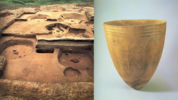
The typical Chulmun dwelling is the pithouse, which is circular or rectangular, dug approximately 50 cm underground, and has a fireplace, wooden posts and thatched roof. Pithouses normally contain daily items such as pottery vessels and diverse stone tools, but do not have food-storage facilities attached to them, nor is there evidence for the co-ownership of food resources by multiple households; it is likely that sizable clay vessels placed within the houses were the principal means of food storage (Fig. 1). Some sites contain large outdoor hearths, which suggest the gathering of many people and communal food consumption.
Excavated pithouse floors (left) and clay vessel (right) of Amsa-dong. (Courtesy of Cultural Heritage Administration, Korea.)

The architectural investments reflected in many pithouses are beyond those represented by logistical camps (Ku Reference Ku2011). Many researchers assumed that the Chulmun people were fully sedentary based on the presence of substantial dwellings and the use of large-sized pottery. The climate of the Korean Peninsula is seasonal, with a dry, cold winter and a wet, hot summer. In the central-western region, the annual precipitation is around 1200 mm, more than 700 mm of which is concentrated in June, July and August during the summer monsoon season. The monthly mean temperature ranges from –2°C in January to 25°C in August (Korea Meteorological Administration 2020). To live through the lean winter season, food storage is imperative. High climatic seasonality and the need for food storage would have decreased residential mobility, although this does not mean that the Chulmun people were fully sedentary with no seasonal mobility (cf. Habu Reference Habu1996).
Previous research has shown that Chulmun settlements were not evenly distributed across the peninsula, and that their number underwent considerable temporal changes. Settlements have mostly been found in the peninsula's southeastern and central-western regions as well as along the eastern coastline (Choe & Bale Reference Choe and Bale2002; M. Kim et al. Reference Kim, Shin and Kim2015). The number of settlements reached its peak c. 3500 bce and began to decline c. 2500 bce; ultimately, only a small number of settlements with only three or fewer pithouses have been found from the period 2500–1500 bce (Ahn et al. Reference Ahn, Kim and Hwang2015; M. Kim et al. Reference Kim, Shin and Kim2015; Oh et al. Reference Oh, Conte, Kang, Kim and Hwang2017). The settlement patterns suggest major changes in the Chulmun communities: their population decreased, people became residentially mobile and/or they relocated to coastal regions.
Chulmun social complexity is a poorly researched topic. The scant research that has been done on this subject has focused on searching for evidence of high-status individuals and an inclination toward vertical social stratification (Ha Reference Ha2009; Shin et al. Reference Shin, Rhee and Aikens2012). A few examples of greenstone pendants, earrings, tubular beads, and shell bracelets discovered from shell middens and burials are the commonly presented evidence for social inequality (Ha Reference Ha2019; Im Reference Im2003; Lee Reference Lee2000; Lim Reference Lim2012; Shin et al. Reference Shin, Rhee and Aikens2012). Circular greenstone earrings and earthen ear tunnels were possibly status markers during the Chulmun period, but the two groups containing 14 and 15 of them, respectively, are geographically concentrated in the southeastern region (Ha Reference Ha2019; Lim Reference Lim2012). The burials are mostly the interments of the dead in shell middens in a relatively haphazard manner, while some untypical burials (e.g. the grave in the Gyo-dong cave and a collective pit grave in Hupo-ri) were discussed in relation to emergent social hierarchy (Nelson Reference Nelson1993). Exotic and luxurious ornaments presumably belonged to individuals with elevated status and socio-economic power. However, given the recent surge in rescue excavations and the long span of the Chulmun period (lasting for millennia), the discovery of only a handful of ornaments that could possibly have served as status markers is rather intriguing. The paucity of prestige goods is more suggestive of an effective management of egalitarian social structure rather than an unrepressed centralization toward hierarchical organization.
Materials and methods
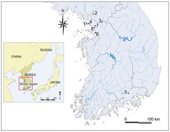
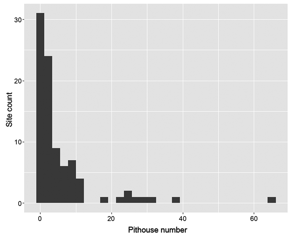
Approximately 750 Chulmun sites have been identified in the southern part of the Korean Peninsula (Ku Reference Ku2011; Ku & Bae Reference Ku and Bae2009); of these, 106 contain at least one pithouse. Most settlements are small-scale and have fewer than five houses, while only eight settlements have more than 20 houses (Figs 2 & 3). As Figure 2 illustrates, most of these large settlements are located in the central-western region of the peninsula, and the reasons for such an uneven distribution need to be investigated in future research. Although the central-western region is believed to have been resource-rich with a mild climate and a high sea-level rise during the Holocene climatic optimum, the region has also undergone extensive urban development over recent decades (So Reference So2013). Urban development led to the discovery of large settlements, and this is best exemplified by Unseo-dong, the largest Chulmun settlement found through a rescue excavation that preceded the construction of Incheon International Airport (Hangang Institute of Cultural Heritage 2012). It is possible that more settlements will be discovered in other regions of the peninsula as the scholarly effort continues. The current examination focused on the eight large settlements that have been fully excavated, and the investigation was conducted using the following procedures.
Location of Chulmun settlements mentioned in the text. (1) Unseo-dong; (2) Daeneung-ri; (3) Amsa-dong; (4) Jungsan-dong; (5) Sangchon-ri; (6) Seoggyo-ri; (7) Neunggok-dong; (8) Singil-dong.

Histogram of Chulmun settlement pithouse numbers.

First, the settlements were resized by excluding houses that were temporally different from the majority. House chronology was determined by stratigraphic information, 14C dates and pottery styles. The stratigraphic relationship was of primary interest because the overlaid relationship between the houses narrowed the range of possibilities in terms of house distribution. The 14C dates allowed the exclusion of dwellings that were clearly from different phases. All coexisting Chulmun houses were presumed to be contemporaneous unless proven otherwise.
The resized settlements were then represented by the maximum number of houses (MaxNH). This measure indicated the largest number of houses that could have coexisted at a single site (Kim et al. Reference Kim, Yi, Kim, Kim, Chung, Kim and Kim2019). Because houses with insufficient chronological information were assumed to be contemporaneous with the majority, this measure presented the maximum value, as the actual number of coexisting houses at a site would have been equal to or smaller than MaxNH. Large-sized settlements whose MaxNH values dropped below 20 were considered ‘palimpsest’ settlements, which implied that a large site size could be due to a long occupational history. Those with MaxNH values equal to or higher than 20 were considered aggregation settlements and were subject to further investigation.
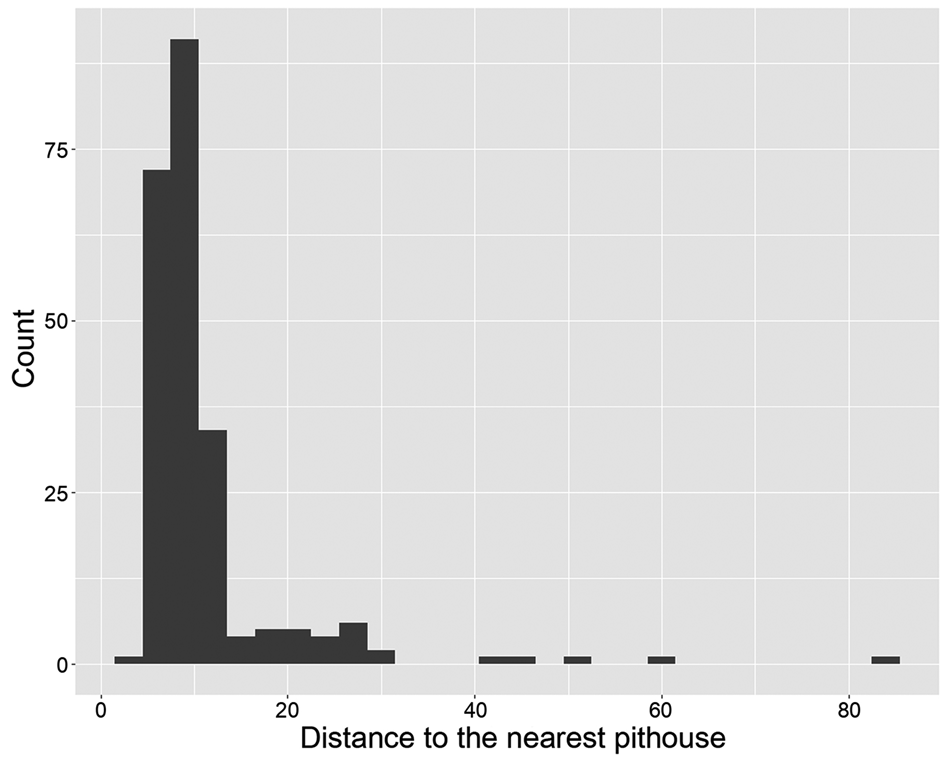
Second, the settlements were inspected for house distribution. As mentioned earlier, most sites under the current examination were unearthed as a part of rescue excavation projects that preceded large-scale construction. The areal scopes for surface surveys, test trenches and excavation covered the entire areas that were under the influence of the subsequent construction. In some cases, the excavated houses were distant from each other, although they were reported as a single site due to the large excavation scale. Figure 4 presents the distances to the nearest pithouse from 229 pithouses in six aggregation settlements (see below for the selection criteria of the six sites). Most of the pithouses (n = 194) have at least one neighbouring pithouse within a 5–13 m range, while some are located distant from the rest. The pithouses that are located more than 30 m distant from the nearest pithouses were considered solitary; accordingly, two house clusters whose intervening zones are wider than 30 m were regarded as different subgroups.
Histogram of the distance to the nearest pithouse (m) from 229 pithouses in aggregation settlements.

Third, the numbers of inhabitants for pithouse clusters were estimated. The estimation relied on previous discussions about the relationship between house floor area and household population (Brown Reference Brown1987; Casselberry Reference Casselberry1974; Dohm Reference Dohm1990; Kolb Reference Kolb1985; Kramer Reference Kramer1982; LeBlanc Reference LeBlanc1971; Naroll Reference Naroll1962; Peterson & Shelach Reference Peterson and Shelach2012; Porčić Reference Porčić2012; Wiessner Reference Wiessner1974; Zorn Reference Zorn2000). The roofed floor areas of individual pithouses were graphically measured using ImageJ software (ver. 1.53a). Areas of circles whose diameters were twice the diameters of the indoor fireplaces were subtracted from the measurements, assuming that the fireplaces and their adjacent zones would not have been habitable. For houses with uncertain floor sizes due to severe destruction, the estimates were substituted by the median areas of intact floors from the same sites. The floor areas were then converted to the household population, assuming a ratio of 6 sq. m per person (Brown Reference Brown1987; Porčić Reference Porčić2012). Finally, the numbers for household members were added to reconstruct the population of pithouse clusters and settlements.
Fourth, the investigation focused on Unseo-dong, the largest Chulmun settlement with 66 pithouses. As will be illustrated below, this site stood out from other settlements for its exceptionally large site size and population. The intra-settlement comparisons started with evaluating whether the Unseo-dong pithouses showed a patterned distribution. The Density-Based Spatial Clustering of Applications with Noise (DBSCAN) algorithm was employed to classify individual pithouses based on their proximity to one another (cf. Caspari & Jendryke Reference Caspari and Jendryke2017; Ester et al. Reference Ester, Kriegel, Sander and Xu1996; Hahsler et al. Reference Hahsler, Piekenbrock and Doran2019). This was followed by quantitative comparisons on house sizes, storage capacities and household activities between the residential clusters. The examination laid the groundwork for discussing whether a stirring toward a pronounced social hierarchy existed within the village, and how this process was eventually truncated.
Population estimates
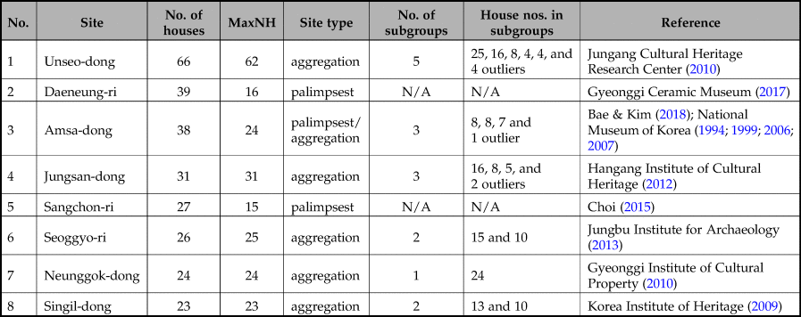
Table 1 presents the data screening results for the eight largest settlements. Sangchon-ri is considered a palimpsest, despite relatively large house numbers. This is a poorly dated site and only two 14C dates are available (Supplementary material). The stratigraphic relationship and pottery styles nonetheless indicated that the pithouses belonged to the Middle Chulmun (n = 15) and the Late Chulmun (n = 12) periods (Choi Reference Choi2015). Daeneung-ri, which contains 39 pithouses, is also considered a palimpsest. The 22 14C dates can be grouped into two: one group is dated back to 3800–3650 bce, the other to 3650–3400 bce (Supplementary material). The site excavators divide the site occupation into three phases based on the 14C dates and pottery chronology (Gyeonggi Ceramic Museum 2017).
Summary of Chulmun settlements with more than 20 pithouses.

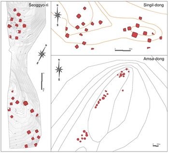
Many aggregation settlements contain multiple residential clusters that are distant from each other. The pithouses of Jungsan-dong are clustered in three different locations that are more than 200 m apart (Hangang Institute of Cultural Heritage 2012). The pithouses represent three different communities, although they were reported as a single site. For some sites, the residential units are contiguous but are still separated by buffering spaces wider than 30 m. Figure 5 presents a few representative examples of discrete residential units. Seoggyo-ri has 25 houses that are dated to c. 3500 bce and are built around two hills. The northwestern hill (33 m above sea level/a.s.l.) has 10 houses, whereas the south-eastern hill (28 m a.s.l.) has 15. Singil-dong (c. 3500 bce) is located on a hill approximately 20 m a.s.l., and the houses are clustered into two groups of 13 and 10; of these, 18 houses show signs of fire and appear to have been simultaneously abandoned. Further, Amsa-dong (c. 3400 bce) is one of the most famous Chulmun settlements (Nelson Reference Nelson1993). Excavations intermittently continued from 1975 to 2018 (Bae & Kim Reference Bae and Kim2018). Many houses were overlaid, revealing some of the settlement's palimpsestic aspects. Nevertheless, the site is divided into three residential clusters, which have essentially equal numbers of houses, two with eight and one with seven.
Representative examples of Chulmun village segmentation.

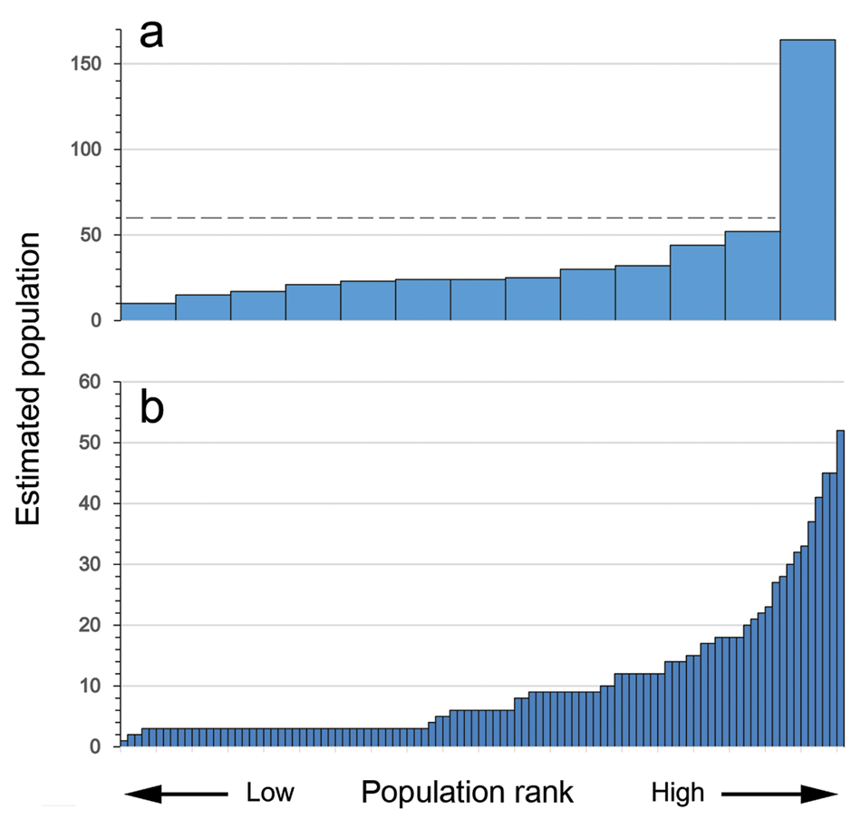
Figure 6 displays the estimated populations of 13 residential units from six aggregation settlements (Fig. 6a) along with those of small settlements with fewer than 20 houses (Fig. 6b). The residential clusters and sites were arranged in rank order from the smallest to the largest population. Most residential clusters in the aggregation settlements range from 10 to 50 in terms of estimated population (Fig. 6a). Unseo-dong (c. 3600 bce) has an exceptionally high estimate of 164, and this site will be scrutinized in detail below. Except for one with an estimate of 52 inhabitants, the populations of small-sized Chulmun settlements do not exceed 45 people (Fig. 6b). They replicate a pattern that was observed from the pithouse clusters in large aggregation settlements excluding Unseo-dong.
Estimated populations of (a) residential clusters of large settlements, house numbers ≥20; (b) small settlements, house numbers <20.

The comparison shows that 60 was close to the saturation point of gatherings of people. Individual settlements consisted of fewer than 60 inhabitants; although people did aggregate beyond this hypothetical limit in a few cases, they remained segregated with a buffering zone between them. All Chulmun settlements showing evidence of aggregation are dated to the middle of the fourth millennium bce and are located on the central-western region of the Korean Peninsula (Fig. 2 and Supplementary material).
Admittedly, the estimated populations are determined by the presumed ratio of floor area per person. This study adopts the conventional assumption of 6 sq. m per person, while many researchers assume higher ratios (Kramer Reference Kramer1982, 125–6; Kuijt Reference Kuijt2000; Peterson & Shelach Reference Peterson and Shelach2012; Zorn Reference Zorn2000). If higher ratios were adopted, the estimated population would naturally drop. Alternatively, if it is assumed that the Chulmun people were mobile hunter-gatherers and built dwellings in an expedient manner using space compactly, the estimated population increases (cf. Porčić Reference Porčić2012). The important point is not necessarily how many people gathered per se, but rather that people maintained manageable group sizes that are applicable to most settlements. On the few occasions when the Chulmun people did gather, they did not increase their group size in an incremental manner; rather, they increased the number of subgroups, which continued to retain manageable sizes.
The case of Unseo-dong
Village segmentation
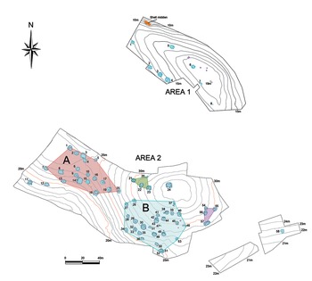
The examination now focuses on Unseo-dong, which was estimated to have had an exceptionally large number of 164 occupants (Figs. 6 & 7). The excavation was conducted at two separate locations (Areas 1 and 2), and this created two distinctive house clusters approximately 120 m apart. Area 1 is a hill 19 m a.s.l, contains eight houses, and is sparse in pithouse distribution with 10 houses in 0.76 ha. Area 2 contains 58 houses built around two hills of 25 and 35 m a.s.l, and the pithouse density is relatively high with 56 houses in 2.1 ha. Despite the many houses, only eight are overlaid, and most houses appear to have been contemporaneous.
Unseo-dong pithouses and DBSCAN clusters.

Researchers have argued that Unseo-dong's pithouse distribution was patterned (Ku Reference Ku2013; Lee Reference Lee2012; Lim Reference Lim2010). The previous discussion, however, relied on the observation of house distribution in a two-dimensional space, rarely considering house elevation. Such an approach is problematic because the houses were built on hills and hillslopes. The location of houses relative to others in a community may be related to their functions and the social status of the occupants (cf. Ames Reference Ames, Bentley, Maschner and Chippindale2008; Feinman & Neitzel Reference Feinman and Neitzel1984); accordingly, it is more informative to cluster houses based on their nearness in a three-dimensional space.
This study employed the DBSCAN algorithm to classify individual houses based on their proximity to one another. DBSCAN proceeds by choosing a random data point and then adding to the cluster any points that are located within a predetermined distance. The newly added data points then become new starting points to determine the membership of others (Ester et al. Reference Ester, Kriegel, Sander and Xu1996). Only two parameters are employed: MinPts (the minimum number of points required to form a cluster) and epsilon (ε, the distance between two points, below which the points are considered neighbours). This method is advantageous in studying village segmentation because it does not require a predefined number of clusters (cf. Caspari & Jendryke Reference Caspari and Jendryke2017). The DBSCAN algorithm was processed using R software packages (Hahsler et al. Reference Hahsler, Piekenbrock and Doran2019).
For Area 2, the following observations are made for house clustering based on the DBSCAN analysis (Fig. 7). First, it contains two large clusters of 17 and 25 houses that centre around two hills; they are designated as Groups A and B, and their estimated populations are 66 and 77, respectively. Second, two small clusters of four houses each are located at the edges of the excavated areas, and their status remains uncertain; they might be a part of larger clusters, or represent growing subgroups that failed to develop fully. These hypotheses can be evaluated only with the expansion of excavation area. Third, four outlying individual houses are distant from the majority; among them, Pithouse #24 is noteworthy because it is a solitary house situated on the highest location. Pithouse #24 overlooks other houses in Area 2, which tend to cluster around it.
Intra-village comparisons
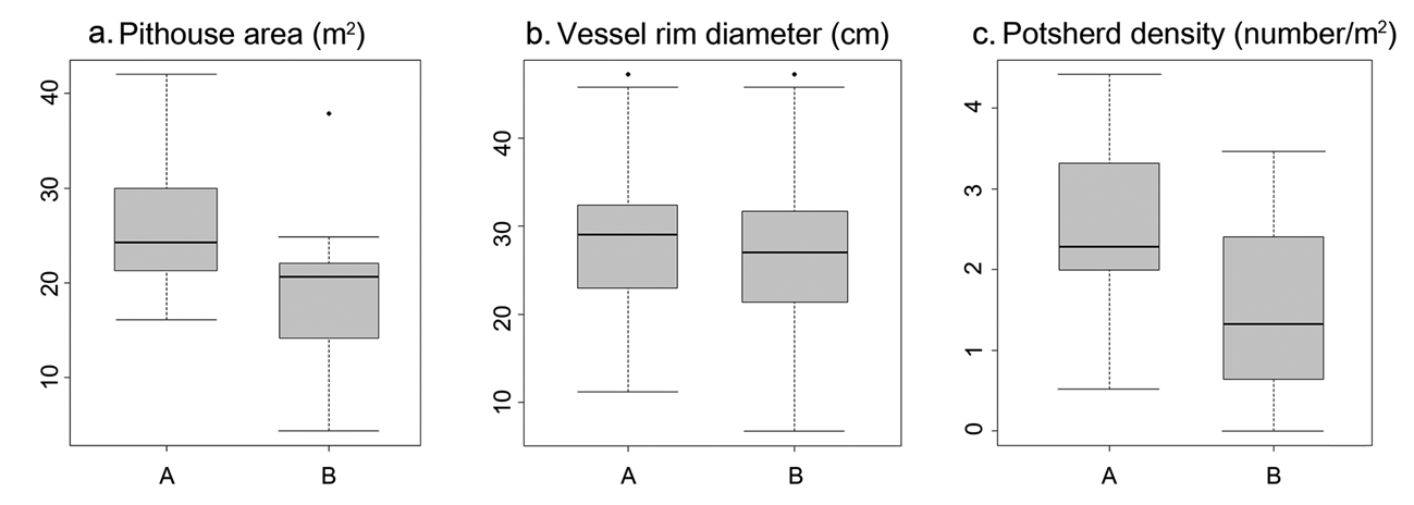
Intra-village comparisons were conducted to understand whether the two large residential clusters (Groups A and B) in Unseo-dong represent two redundant, homologous units, or whether they differ from each other in storage capacities and household activities. Both are comparable in size in terms of the estimated population and occupation areas: Group A has 66 people in 0.24 ha, whereas Group B has 77 people in 0.32 ha. However, the pithouses in Group A measure 25.6 sq. m on average (n = 18, SD = 7.7), and those in Group B are 18.1 sq. m (n = 31, SD = 6.9) (Fig. 8a); their size difference is statistically significant (t = 3.52; p < 0.01). In short, the southwestern hill has fewer houses but larger ones, whereas the southeastern hill has more houses, albeit smaller ones. Although it is tempting to hypothesize that two clusters were temporally different, no evidence from 14C dates, pottery styles, or stratigraphic observation supports this possibility (Jungang Cultural Heritage Research Centre 2010).
Comparison of pithouse area, vessel rim diameter and potsherd density between Groups A and B in Area 2, Unseo-dong.

Although mostly only potsherds remained, some are comparatively large, and their original rim diameters can be reconstructed. The Chulmun clay vessels are large conical pots, and their rim diameters are correlated with the vessel volumes (Fig. 9). The comparison shows that size differences are not significant between the groups (Fig. 8b). Petrographic analysis and scanning electron microscope observation have suggested that the clay vessels of Unseo-dong were similar in raw material composition and that they were fired at c. 750–900°C in outdoor hearths (Cho Reference Cho2010). No significant difference was noted in terms of strength and durability among the vessels. Provided that pottery had the same rate of fragmentation across different archaeological features, the vessel amounts are assumed to be correlated with the potsherd densities. For this comparison, potsherds with remaining surfaces larger than 5×5 cm (or 25 sq. cm for elongated or irregular-shaped fragments) were counted, and the amounts were standardized by pithouse areas. The difference is statistically significant between the groups (Fig. 8c; t = 2.90; p < 0.01). The Group A houses are high in pottery density (n = 18, M = 2.47, SD = 1.10), whereas the Group B houses are low (n = 31, M = 1.52, SD = 1.11). In other words, Group A houses had larger storage capacity; they did not necessarily use bigger pots, but had many of them. This observation partly explains why Group A's houses were more spacious than Group B's, suggesting that it was related to the amount of food matter stored in the houses. It also implies that the population of Group A might have been less than the current estimation of 66 because the sizable quantity of storage vessels would have taken up some indoor space.
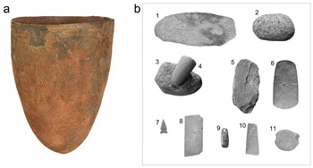
Clay vessel (a) and representative stone tools (b) from Unseo-dong (scales vary): (1) grinding slab; (2) grinding stone; (3) mortar; (4) pestle; (5) chipped stone axe; (6) polished stone axe; (7) projectile point; (8) whetstone; (9) ornament; (10) chisel; (11) net sinker.

The comparison continues with stone tools. The stone tools from Unseo-dong are classified into 11 categories: (1) grinding slabs, (2) grinding stones, (3) mortars, (4) pestles, (5) chipped stone axes, (6) polished stone axes, (7) projectile points, (8) whetstones, (9) ornaments, (10) chisels and (11) net sinkers (Fig. 9). Grinding slabs and stones, mortars and pestles were used to process food materials, for example dehusking and grinding nuts and cereals. Grinding slabs tend to be flat, whereas mortars have concave surfaces; therefore, they would have served different functions. Chipped or ground stone axes were versatile tools and possibly served multiple functions, such as digging, hammering and woodworking. Whetstones were used for manufacturing other types of polished stone tools, and chisels were used for processing wooden materials.
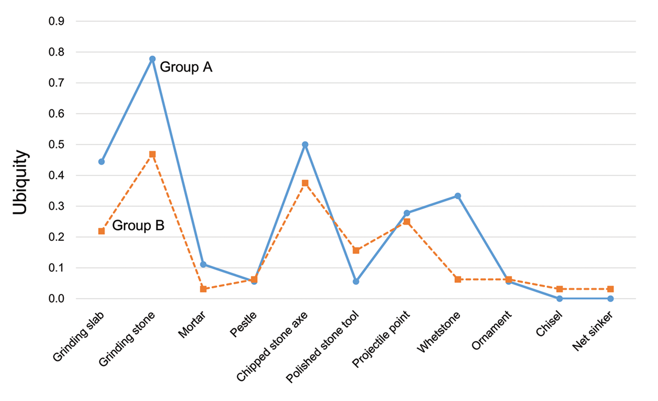
For all pithouses in Area 2, an area of approximately 6 sq. m contains one stone tool of any kind, and no meaningful density difference is detected between the subgroups. However, stone tool assemblages of individual houses contain distinctive categories, and some compositional changes are noted. Figure 10 presents the stone tool ubiquity across the Unseo-dong pithouses. This measures the presence and absence of a particular stone tool category in the excavated houses, regardless of their abundance. It ranges from 0 (stone tool was not discovered in any pithouse) to 1.00 (stone tool was discovered in all pithouses). Although the patterns are generally similar between the subgroups, some stone tools are more frequently found in Group A, such as grinding slabs and stones, and whetstones. The evidence for food processing and tool polishing is more common in Group A than in Group B.
Comparison of stone tool ubiquity between Groups A and B in Area 2, Unseo-dong.

The patterned differences between the subgroups are subject to multiple interpretations. The general impression is that Group A was ‘heavier’ and Group B was ‘lighter’. Group A built larger houses and had more storage vessels; they also had more stone artefacts for indoor works (i.e. grinding and polishing). Group B built smaller houses and had fewer storage vessels as well as fewer stone tools for indoor works. The observed differences may be related to inter-subgroup variations in economic potential. This interpretation raises the question of how people resolved the tensions that could have originated from unequal economic wealth between the neighbouring groups. Alternatively, but not mutually exclusively, the differences may be related to differential occupational spans of the subgroups. People who stayed at the site for a prolonged span would have needed a large storage capability and invested more on immobile toolkits, whereas those with shorter spans would not. Although it is difficult to determine the reasons, the present study shows that the two residential groups were not homologous units. Pithouse locations, storage capacities and household activities showed concurrent differences. People presumably retained their subgroup identities despite the residential proximity.
Evidence for social differentiation
Unseo-dong is located on the island of Yeongjong, 3 km off the central-western coast of the Korean Peninsula (Fig. 2). Fresh water is available, albeit in limited amounts as there are no rivers or lakes. This is not an ideal location for intensive agriculture, though plant cultivation would not have been impossible. Although it is an island, it is not necessarily isolated; people can easily reach the mainland on a boat or raft, taking advantage of the tides. This raises a question as to why people decided to gather on this island when there was a vast amount of land with a low population density just across a narrow strip of water.
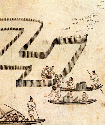
So (Reference So2012) draws on ethnographic analogy and argues that the management of fish weirs drew people together. The western coast of the Korean Peninsula is characterized by a wide tidal range. The difference between high and low tides varies along the coastline; at about 8 m, it is particularly large in the study region (Kwon et al. Reference Kwon, Kim, Lee and Jung2016). Intertidal mudflats have developed along the shorelines due to the combination of multiple factors such as wide tidal range, gently sloped ocean floor and sediment and microbial influx from peninsular rivers. They contribute to resource abundance and diversity and provide habitats for birds and shellfish as well as spawning places for fish (Lee & Kim Reference Lee, Kim, Kim, Lee, Kong and Kim2012). In the study area, fish weirs represent a traditional fishing method that entails placing wood and bamboo obstructions in the intertidal zone to trap marine fish (Fig. 11). In terms of local linguistic expressions, people ‘gather’ fish rather than ‘catching’ them (Ju Reference Ju2006). Ethnographic observations further imply that many people must collaborate to build and maintain fish weirs (National Folk Museum of Korea 1996). Although fish weirs are a plausible hypothesis for explaining why people chose to gather in Unseo-dong, they remain archaeologically unverified. It is difficult to find material evidence for such structures as they were built under water with organic materials.
Painting of fish weir and fishing activities. (Hongdo Kim, Fishing. Late eighteenth century ce. National Museum of Korea, Seoul, Republic of Korea.)

Whatever the reason for aggregation, some Unseo-dong houses suggest a low level of social differentiation. As mentioned earlier, Pithouse #24 is situated on the highest location and is distant from other houses (Fig. 7); it may have been the residence of an emergent elite who transcended any subgroup membership. The floor area measures 40.9 sq. m, being significantly larger than other houses that measure 22.1 sq. m on average (SD = 7.14). However, the house does not appear to be functionally different. The excavated artefacts include grinding slabs, projectile points and chipped stone axes, which have commonly been found in other houses (Jungang Cultural Heritage Research Centre 2010).
Pithouses #14 (Area 2, west) and #30 (Area 2, east) are noted for signs of stone tool making (Fig. 7). Both houses contain more than 10 hammer stones, which are retouched quartzite balls of approximately 10 cm in diameter and 370 g in weight. Experimental research on use-wear patterns showed that these implements were used to manufacture other stone tools (Kim & Kim Reference Kim and Kim2012); due to the hardness of quartzite, the hammer stones would have been effective at shaping tools of other stone types. Pithouse #14 contains 33 stone remains of semi-finished projectile points. The large number of partially finished projectile points is intriguing because other houses have only one or two finished ones at most. Pithouses #14 and #30 are the largest houses in their respective clusters. Nevertheless, these structures do not appear to have been fully dedicated workshops. The houses contain potsherds and domestic stone tools such as grinding slabs, mortars and axes, suggesting an array of domestic activities (Jungang Cultural Heritage Research Centre 2010).
Discussion: emergent elites and fissioning
Normally, the Chulmun people stayed in small groups. The pithouses were usually smaller than 30 sq. m, and the settlement typically contained fewer than five pithouses; the maximum number of people would rarely have exceeded 60. This does not mean that gathering did not occur. Abundant shell middens raise the possibility that people seasonally gathered to collect shellfish; however, most shell middens are not associated with pithouses, and the sites appear to be the results of logistical forays (Kim Reference Kim2003; Reference Kim2010). Some large shell middens on the southeastern coast, e.g. Tongsam-dong, have associated pithouses, but never more than three (Kim et al. Reference Kim, Shin and Kim2015). Large-scale gatherings, if they occurred, would have been temporary. People did gather for prolonged spans in some cases, which is indicated by a few settlements with more than 20 pithouses. Most of these gathering sites are dated to c. 3500 bce, and they are found in the central-western region of the Korean Peninsula. The aggregation does not mean that the population increased in an incremental manner; when people gathered, they remained segmented, and many aggregation settlements consist of residential clusters that are roughly equal in size.
The establishment of aggregation settlements would have created a new setting for status competition and socio-political reorganization. As people aggregate, individuals and families are expected to go through a social process of repositioning themselves vis-à-vis one another. It also necessitates the enactment of consensual rules that alleviate problems of social crowding (e.g. lack of privacy, information overload, poor sanitation, loss of private control over resources and difficulty in monitoring free riders) and the establishment of high-level integrative institutions that mitigate scalar stress and settle disputes among the community members. Accordingly, the question that needs to be addressed is whether new social arrangements emerged and some individuals could consolidate power and prestige over others under the circumstances of nucleated villages like Unseo-dong (cf. Carballo et al. Reference Carballo, Roscoe and Feinman2014; DeMarrais & Earle Reference DeMarrais and Earle2017; Glowacki & von Rueden Reference Glowacki and von Rueden2015; Ostrom & Gardner Reference Ostrom and Gardner1993; Tyler Reference Tyler2002; von Rueden et al. Reference von Rueden, Gurven, Kaplan and Stieglitz2014).
The datasets from Unseo-dong suggest inter-household differences within the community, and some individuals (e.g. the occupants of Pithouses #14 and #30) are envisioned as craft specialists. Judging from the abundance of half-finished artefacts and manufacturing tools, people in these houses produced lithic goods beyond their immediate needs. The skills and experience associated with production activities could have been a source of prestige and authority. Some individuals from these houses might have achieved elevated status within the community based on their personal skills. However, there is no evidence to indicate that they recruited and controlled labour from other families. The stone-tool making appears to have been a strictly household business. Exotic materials such as obsidian were absent, and the craftspeople were not involved in exchanges and alliance formation across a wide region.
Alternatively, some people are envisioned as coordinators in communal works. Researchers have argued that the large quantities of nearshore fish and the contrasting paucity of fishing tools recovered from shell middens imply the operation of mass-capture technology on the western coast of the Korean Peninsula (Shin et al. Reference Shin, Rhee and Aikens2012). Although material evidence is difficult to find, the use of tidal fish weirs is a plausible scenario. Fish weirs have been used on the western coast until recently, and as the ethnohistorical documents illustrate, people needed community-wide cooperation for the construction and maintenance of fishing systems (National Folk Museum of Korea 1996). The collective benefits gleaned from the immobile capital would have made group fission highly costly; thus, people had to stay together to maximize their individual shares. Under such circumstance, some individuals could have elevated their status and enjoyed a privileged position within the community, achieving this by emphasizing their managerial roles in the operation of group-owned production means.
The consolidation of personal power and the repressing of emergent inequality are two sides of the same coin, and we need to assume that both were in action. I argue that the latter eventually prevailed in the Chulmun contexts. An increase in group size naturally intensifies intragroup tension and conflict (Alberti Reference Alberti2014; Dunbar Reference Dunbar2003; Fletcher Reference Fletcher1995; Johnson Reference Johnson, Renfrew, Rowlands and Segraves1982; Rappaport Reference Rappaport1968). People stay together when aggregation benefits all group members. Individuals and subgroups measure the costs and benefits of remaining in a large group, and decide to leave if they could gain more by doing so. Unseo-dong was a densely populated settlement with some indications of social hierarchy. However, the emergent social complexity did not intensify further. Settlements that post-dated Unseo-dong in the region are small in scale. Jungsan-dong was the only aggregation settlement with 31 houses, but these were separated into three distant residential zones constituting different communities. All other settlements had fewer than 20 houses with no sign of socio-economic inequality (Kim Reference Kim2017).
Throughout the Chulmun period, acorns (Quercus) were the important food resource. They are seasonal but spatially unbound. Both deciduous and evergreen oaks are native to the Korean Peninsula. Deciduous taxa like Quercus acutissima, Q. mongolica and Q. dentata are particularly abundant in the region above latitude 35° and at an altitude below 800 m (Kim & Kim Reference Kim and Kim2017). Pollen research has also demonstrated that the oak was one of the most abundant tree taxa during the Holocene (Choi Reference Choi1998). Although acorns are still gathered as food in large quantities in modern-day Korea, they have never been cultivated (Overstreet et al. Reference Overstreet, Choi, Park, Lee and Gradziel2015). As a seasonal resource, they would have decreased residential mobility, though at the same time, the reliance on such a dispersed resource would have made group fission less costly.
The cultivation of millet does not necessarily increase group size. Foxtail millet and broomcorn millet are adaptable to a wide range of habitats. They require small amounts of water and can tolerate dry climates and sandy soils (Weber & Fuller Reference Weber and Fuller2008; Weber et al. Reference Weber, Lehman, Barela, Hawks and Harriman2010). Millet cultivation does not demand high population density and labour input, as expected in wet-rice cultivation (Frachetti et al. Reference Frachetti, Spengler, Fritz and Mar'yashev2010; Lightfoot et al. Reference Lightfoot, Motuzaite-Matuzeviciute and O'Connell2015). Millet cultivation was a weak bond to draw many people together.
The low cost of fissioning is closely tied to egalitarianism, which is induced by external factors (e.g. scattered and unpredictable resources) and purposeful behaviours (e.g. deposition, disobedience, ridicule and fission) (Boehm Reference Boehm1993). Not all of them are equally visible from archaeological records; the investigation of the Chulmun settlements demonstrates that at least a combination of the two (i.e. scattered resources and group fission) was in effective operation. Although Unseo-dong possibly had some individuals with skills and prestige, their personal traits did not lead to centralized political leadership in the long term. The Chulmun people normally maintained small group sizes. On a few occasions, when relatively many people gathered, people remained segregated and maintained manageable group sizes for the subunits. As it is a common practice for politically autonomous societies to organize villages into a few opposable segments (Marcus Reference Marcus2008), it is also likely that the practice of village segmentation facilitated group fission in the face of high costs for large groups during the Chulmun period.
Conclusion
Aggregation, which has appeared in the forms of nucleated villages and cities, has been an important research topic in social sciences. Archaeology can contribute significantly by offering insight from a long-term perspective. When people gather, they do so for certain reasons; they evaluate the costs and benefits of staying in large groups and decide to leave if the large group size becomes too costly. This would have been a common situation in many hunter-gatherer and incipient agriculturalist communities with a lack of centralized, coercive leadership.
People will stay together if collaborative labour is more rewarding than individual endeavours. Then, aggregation creates an arena for status competition. When people gather for a common aim, the would-be elites can present themselves as the ‘first among equals’ and employ corporate-oriented leadership strategies (cf. Blanton et al. Reference Blanton, Feinman, Kowalewski and Peregrine1996). This scenario is particularly fitting for Unseo-dong, where we find evidence for aggregation and some indications of social differentiation, as well as an environmental condition suitable for collective fishing. However, social complexity did not move to higher levels. Because people relied on food resources that were predictable and scattered, such as acorns, new communities could easily settle in other locations. With the low costs of group dispersion, people could easily suppress the self-aggrandisement of aspiring individuals. Overall, the Chulmun datasets demonstrate a continuous social process of decentralization and fragmentation rather than a successful consolidation of individual power and authority.
Previous studies on Chulmun social complexity have focused on whether Chulmun society was egalitarian or not and presented a few luxurious and exotic ornaments as evidence of social inequality. Although these artefacts suggest the presence of some individuals who had more prestige and wealth than others, the scarcity of objects that possibly functioned as status markers needs to be highlighted. The question of Chulmun social complexity must be reoriented to address how people successfully controlled the political ambitions of would-be elites over centuries and millennia. Levelling mechanisms were clearly in operation, and as this study illustrates, maintaining small group sizes was a powerful such mechanism.
Acknowledgements
This work was supported by the Ministry of Education of the Republic of Korea and the National Research Foundation of Korea (NRF-2017S1A5A2A01024541).
Supplementary material
14C dates of the settlements mentioned in the text: https://doi.org/10.1017/S0959774321000433