

Introduction
Brown Planthopper (BPH, Nilaparvata lugens (Stål)) is one of the most serious pests of rice in both temperate and tropical regions of East and South Asia. It was an unimportant pest and disregarded in rice fields until an outbreak was experienced in 1968. In the 1970s and 1980s, the frequency of BPH outbreaks continued to increase until the population was controlled in the 1990s by the use of buprofezin and imidacloprid (Cheng et al., Reference Cheng, Wu and Ma2003). However, in the past few years new outbreaks of BPH have been continuously recorded. According to figures from the Ministry of Agriculture of China (Guo & Zhao, Reference Guo and Zhao2006), the loss of rice yield caused by BPH was approximately 1,880,000 t in 2005.
BPH cannot overwinter in temperate zones, such as mainland China, Japan and the Korean Peninsula. Instead, infestations are initiated by windborne spring/summer migrants from Southeast Asia and/or South Asia. Planthopper migration has been studied in several regions of East Asia since the 1970s (Asahina & Turuoka, Reference Asahina and Turuoka1968; Kisimoto, Reference Kisimoto1971, Reference Kisimoto1984; Cheng et al., Reference Cheng, Chen, Xi, Yang, Zhu, Wu, Qian and Yang1979, Reference Cheng, Wu and Ma2003; Guangxi Coordinated Research Group for Brown Planthoppers, 1979; National Coordinated Research Group for Brown Planthoppers, 1982; Kisimoto & Sogawa, 1995); and, as a result, the fundamental pattern of BPH migration is now sufficiently well understood. It begins with a northward migration occurring in late March every year. The distribution of BPH is then further expanded northward by progeny of the migrant population and can extend over the whole rice-growing region in East Asia, as well as into Japan and the Korean Peninsula. From September onwards, the general direction of planthopper migration becomes predominantly south bound. After the end of October, most BPH return to safe overwintering areas, mainly in the Indo-China Peninsula. In total, there are five waves of northward migrants and three waves of returning migrants each year. Cheng et al. (Reference Cheng, Chen, Xi, Yang, Zhu, Wu, Qian and Yang1979) divided China into eight ‘occurrence zones’ for BPH, according to differences in climate and rice cropping systems in different latitudinal ranges.
The development of BPH populations includes three main stages: landing to settle down, local reproduction and emigration. Each stage is affected by the developmental stage of rice plants. In a study on white-backed planthopper Sogatella furcifera (Horvath), it was noted that most insects settled in the dense, young rice plants after landing (Hu et al., Reference Hu, Xie and Wang1987). According to field observations by Cheng (unpublished data), adult BPH tend to settle in rice paddies that are at active tillering and booting stages. In this same work, few adults landed in paddies where rice was at the initial tillering stage or the yellow ripe stage.
In fields, BPH tend to feed mostly on rice plants that are between the final tillering and grain filling stage (Cheng et al., Reference Cheng, Wu and Ma2003). The developmental rate, survival rate and fecundity of BPH bred on rice plants of five developmental stages were measured and compared under field conditions by Chen et al. (Reference Chen, Qi, Cheng, Ding and Wu1986). The longest lifespan of adults, the highest fecundity, the highest survival rate of nymphs and the highest rm (the intrinsic capacity of increase) were found in the populations bred on plants from the tillering stage to the elongation stage. Conversely, BPH bred on plants at younger stages or at the filling stage displayed a reduced survival rate of nymphs and shorter adult longevity. Fecundity was also reduced on these plants, especially in mature stages. Therefore, the development of BPH populations appears to be associated with the growth stages of the rice plants on which they feed.
The nutritional status of rice is the main factor determining wing dimorphism of BPH. When the rice plants grow vigorously, more brachypterous adults emerge, with macropters being significantly greater than brachyptery when rice plants senesce and their nutritional status deteriorates (Wang & Zhang, Reference Wang and Zhang1981; Zhang, Reference Zhang1983; Wang et al., Reference Wang, Du and Cheng1997). In migratory species that display wing dimorphism, the proportion of macropterous individuals within a population is generally responsible for the migratory potential (Wilson, Reference Wilson, Drake and Gatehouse1995). The migration of BPH is thus synchronized with the deterioration of their food source (Cheng et al., Reference Cheng, Wu and Ma2003). The nutritional status of rice at the yellow mature stage, therefore, promotes the emergence of macropters and the population begins to emigrate as a result (Chen & Cheng, Reference Chen and Cheng1980).
The distribution of rice at different growth stages is determined by the rice cropping system, which in turn determines the distribution of BPH habitat in both space and time. The change in rice cropping systems began in Jiangsu in the 1980s with double-cropping rice being converted to single-cropping rice. Under double-cropping rice systems, early (season) rice and late (season) rice are planted successively in the same year. After the early rice is harvested in summer, the paddies are ploughed and levelled for transplanting late rice. However, single cropping rice is generally planted later than early rice, i.e. mid-season. The rice cropping system has been altered for the past 30 years, but little is known regarding how this change has affected the population dynamics and migration pattern of BPH. In view of this, in the present study, field surveys on BPH were performed in approximately 40 counties of six provinces (or municipalities), including Hainan, Guangxi, Anhui, Shanghai, Fujian and Guangdong from April to October in 2007. The aim of this work was to generate data regarding the population dynamics of BPH in these areas and to gain a better understanding of the relationship between migratory insects and their environment per se. This was achieved with BPH by direct field collection from experimental paddies, light trap catches and ovary dissection. The impact of the change of rice cropping systems on the population dynamics and migration of BPH was also analyzed and suggestions for forecasting and controlling BPH are provided.
Materials and methods
Light trap
Daily BPH light trap data were provided by local plant protection stations (PPSs). In most cases, the PPSs used frequoscillation lamps (Jiaduo Brand, Jiaduo Science, Industry and Trade Co. Ltd, Henan Province) for catching planthoppers, which have replaced black-light traps since 2005. However, black-light traps were still located in a few stations. At this time, there have been no comparative studies on the efficacy of the two types of light traps to catch BPH. Comparisons between light traps in different stations were not made in this study.
Systematic field investigation
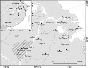
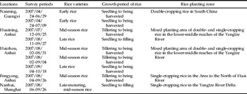
In 2007, nine paddies in Guangxi, Anhui and Shanghai were selected as experimental sites to investigate the population dynamics of BPH (table 1, fig. 1). These paddies were moderately fertile with routine cultural practices and no pesticide use to control pests during the rice growing season.
Survey locations and county plant protection stations. ★, locations of the experimental fields; ▲, the name of other places mentioned in the text; the region indicated by filled oblique lines is Anqing Region, Anhui Province; the lower-middle reaches of Yangtze River include Hunan, Hubei, Jiangxi, Anhui, Zhejiang, Jiangsu and Shanghai (a municipality near the mouth of Yangtze River, and both Nanhui and Fengxian locate in it); the Yangtze River Delta include South Jiangsu, North Zhejiang and Shanghai.

Description of experimental sites.

Systematic field investigation of BPH populations was undertaken once every three days. A plate (39 cm×29.5 cm×2 cm) was inserted at the base of the rice plants and, by shaking the plants, BPH dropped into the plate. The numbers of BPH per hill (including all tillers growing from a seedling and also named ‘clump’) were counted by eye. This method was called the plant-shaking method.
In the early vegetative period, when the rice plants were small, BPH were few in number, 20 or 40 plots were selected and five hills per plot were sampled for BPH, 100 or 200 hills in total. After the middle tillering stage, rice plants were denser and BPH were more numerous. Therefore, 25 or 50 plots were sampled with two hills sampled per plot. If the density of BPH was too large for counting, only one hill was shaken per plot. The damage assessment was made by eyeballing roughly. If there was no obvious damage or only few, about 1%, rice plants lodged, the damage degree was ‘ little’; if a large area of rice lodged, above 10%, the degree was ‘severe’; if all plants lodged, the extreme damage was ‘crop failure’.
Ovary dissection
Macropterous females of BPH were collected from paddies in Huaining and Nanhui and dissected daily. By dissecting macropterous females and estimating the level of ovary development, Chen et al. (Reference Chen, Cheng, Yan and Yin1979) classified the ovarian development into five levels and related it to the migration status of the population. According to his criteria, ovary is almost at the initial stage, and the level of ovary development is entirely level-I in source areas or during the emigration period. However, during the immigration period or in landing areas, migrants landed and oocytes continued to develop immediately. The ovaries of most females in the field were mature and at level-III or above.
Trajectory analysis
Likely source and landing areas of migratory BPH were defined by constructing backward/forward trajectories, which were based on assumptions that: (i) the planthoppers were displaced downwind (Chen & Cheng, Reference Chen and Cheng1980; Deng, Reference Deng1981; Riley et al., Reference Riley, Cheng, Zhang, Reynolds, Xu, Smith, Cheng, Bao and Zhai1991, Reference Riley, Reynolds, Smith, Rosenberg, Cheng, Zhang, Xu, Cheng, Bao, Zhai and Wang1994); (ii) take-off was mostly at dusk and partly at dawn (Chen & Cheng, Reference Chen and Cheng1980; Deng, Reference Deng1981; Riley et al., Reference Riley, Cheng, Zhang, Reynolds, Xu, Smith, Cheng, Bao and Zhai1991, Reference Riley, Reynolds, Smith, Rosenberg, Cheng, Zhang, Xu, Cheng, Bao, Zhai and Wang1994); (iii) movement occurred at the height of 850 hPa (Deng, Reference Deng1981; Riley et al., Reference Riley, Cheng, Zhang, Reynolds, Xu, Smith, Cheng, Bao and Zhai1991, Reference Riley, Reynolds, Smith, Rosenberg, Cheng, Zhang, Xu, Cheng, Bao, Zhai and Wang1994). With the NCEP global data assimilation system (GDAS) archive which is a three-hourly, global, 1-degree latitude longitude dataset, the NOAA ARL HYSPLIT Model (Draxler & Hess, Reference Draxler and Hess1998; Zhu et al., Reference Zhu, Edward, David, Ian and Mark2005) was applied to calculate trajectories. The backward trajectories for light trap locations were calculated for every hour during peak periods, with the initial height at 800 m, 1500 m and 2000 m above ground level. These trajectories terminated at the take-off time of BPH, viz. 18:00 or 6:00 (BJT: Beijing Time). The duration of trajectories did not exceed 37 h (Cheng et al., Reference Cheng, Chen, Xi, Yang, Zhu, Wu, Qian and Yang1979). If an endpoint of a trajectory was located in a rice planting area where the crop was at a later growth stage, this endpoint was considered to be a likely source. The start points of forward trajectories, which were source areas of BPH, were assessed at the initial time of dusk (about 18:00 BJT), at initial heights of 800 m, 1500 m and 2000 m above ground level.
Results
Rice planting system and the outbreak of BPH
The evolution of the rice planting system in the lower-middle reaches of the Yangtze River
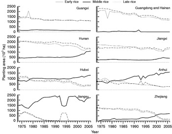
The lower-middle reaches of the Yangtze River include Hunan, Hubei, Jiangxi, Anhui, Jiangsu, Zhejiang and Shanghai. Sixty percent of the country's rice is grown in this region, and the damage caused by BPH is usually more frequent and serious than that in other regions. Double-cropping rice was mainly planted from the 1960s to the 1990s in this region; but, since this time, the region has been divided into two, according to the rice planting system. One region, including Hubei, South and Central Anhui, North Hunan and North Jiangxi, now consists of mixed planting areas where both single- and double-cropping occur. The other is the Yangtze River Delta (Jiangsu and Zhejiang in fig. 2), in which single-cropping has been dominant since 1997.
The rice planting areas in major producing provinces since 1973. The variation in rice planting in Shanghai Municipality is the same as in Jiangsu, but the area is far less than that in Jiangsu. The data of rice planting was downloaded from crop database (http://zzys.agri.gov.cn/) published by Ministry of Agriculture of China (––, early rice; ––, middle rice; - - - -, late rice).

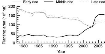
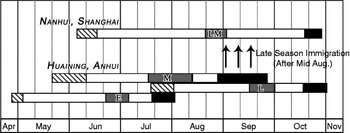
In the mixed planting areas, the extent of double-cropping rice has been greatly reduced and single-cropping has been increasing rapidly since 1997, especially after 2003 (Hunan, Hubei, Jiangxi and Anhui in fig. 2). For example, the area of single-cropping rice in Anqing Region, Anhui Province, was 7.8% of the total rice planting area in this region in 1978 and 41% in 2007 (fig. 3). The early rice in this area was harvested between late July and early August. The mid-season rice was subsequently transplanted between late May and early June, maturing in late August, with most of the rice harvested in early and middle September. Some late-maturing mid-season rice was harvested in late September and early October. The late rice was transplanted after the harvest of early rice and harvested after late October (fig. 4).
The rice planting area in Anqing Region since 1978. The data was provided by Anqing plant protection station (––, early rice; ––, middle rice; - - - -, late rice).

Sketch map of rice growth periods in Huaining (Anqing Region, Anhui Province) and Nanhui (Shanghai Municipality). LM, late-maturing mid-season rice; M, mid-season rice; L, late rice; E, early rice ( , rice translanting;
 , rice heading stage; ▪, rice harvest stage).

However, the single-cropping rice in the Yangtze River Delta was late-maturing middle rice, which was transplanted in mid- and late June and harvested in late October (fig. 4).
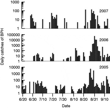
The early immigration of BPH in the mixed planting areas in June and July
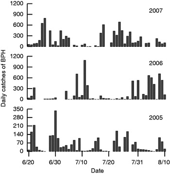
There were two main peak periods of BPH immigration in the mixed planting areas in the early season of 2007 (fig. 5). The first peak period appeared from June 21st to July 5th. This peak period corresponded with the maturing and harvesting of early rice in the southern parts (south of 23.43°N) of South China, which includes South Guangdong and South Guangxi.
The daily variation in the light trap catches in Qianshan (Anqing Region, Anhui Province) in 2005, 2006 and 2007. These data were provided by Qianshan plant protection station.

The second peak immigration period was from July 17th to August 10th. Peaks of light trapped insects commonly occurred at most PPSs in Anhui during this period, such as Jingxian (the maximum catch by light trap during this time was 400), Guichi (992), Dongzhi (208), Tongcheng (416), Fanchang (864), Wuwei (408), Jin'an (672) and Fengyang (152). Early rice in the regions north of 23.43°N in South China matured and was harvested at this time.
In 2005 and 2006, there were also two main immigratory peak periods in the early season: late June to early July and late July to early August (fig. 5). The results from these immigratory peak periods were the same as those obtained by Cheng et al. in 1979. As the rice planting structure in South China has been unchanged since 1979, the harvest schedule of early rice has accordingly remained stable (fig. 2).
The local damage caused by BPH and mass late emigration of BPH in middle rice paddies in the mixed planting area
From late June to late July, early rice had already matured and been partly harvested, while most of the late rice had not yet been transplanted. Therefore, very few BPH landed in double-cropping rice paddies. However, the single-cropping rice, i.e. mid-season rice, was at the tillering, jointing or booting stage and fit for BPH. Most of BPH, therefore, settled in single-cropping paddies at this time.
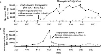
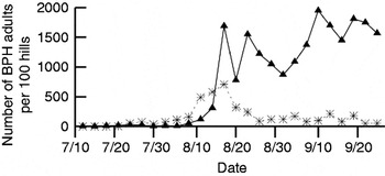
The BPH population in single-cropping rice paddies grew so quickly that it resulted in heavy damage due to the suitable habitat and abundant food that these paddies offered. In the experimental mid-season rice paddy in Huaining, the population outbreak of BPH began in early August and a large number of brachypterous BPH had already emerged by mid-August. On August 17th, the numbers of BPH were 9320 per 100 hills. Among these, the macropterous adults numbered 4090 (44%) and brachypterous adults numbered 710 (7.6%) (figs 6a and 7). The high proportion of macropters indicated that BPH were preparing to emigrate. On August 29th, the numbers of BPH were 11,440 per 100 hills. This large number of BPH resulted in ‘hopperburn’ (browning of the leaves or withering of the whole plant). Rice plants were generally flattened and crop failures ultimately occurred. The population dynamics of BPH in mid-season rice paddies in Huizhou were similar to those seen in Huaining and the damage caused by BPH again led to crop failures. The rice growth period in Huizhou was somewhat earlier than that in Huaining, and mid-season rice was harvested in late August.
The population dynamics of BPH in (a) experimental paddies in Huaining in 2007 and (b) farmers’ paddies in Anqing Region in 2006. The data of BPH population dynamics in farmers’ paddies in 2006 was provided by Anqing plant protection station (–▲–, single-cropping rice;  , double-cropping late rice).

The population dynamics of BPH adults in experimental mid-season rice paddies in Huaining (–▲–, macropters; - - -- - -, brachypters).

The results of ovary dissection also verified that the macropters were from local populations and had started to emigrate. During August 17th–31st, 307 macropterous females were dissected. The number of individuals with ovaries at level-I was 248 (80.8%) with level-II ovaries near 10.4%, while those at level-III and above were only 8.8%. According to the classification criteria established by Chen et al. (Reference Chen, Cheng, Yan and Yin1979), such figures typify an emigrating population. At this time, the rice was at blooming stage and the vegetative growth of rice was switching to the reproductive phase, and the high population pressure induced macropterous adults to emigrate.
The numbers of BPH in double-cropping rice paddies were much lower. After early rice was harvested in summer, the paddies were ploughed and levelled for transplanting late rice. The growth of BPH populations in double-cropping paddies might have been interrupted by these farming activities. There were constraints on the movement of BPH from early rice to late rice. In Huaining, the initial tillering stage of late rice was in August. The BPH population grew slowly to attain a maximum density of only 4610 individuals per 100 hills in late September. There was no severe damage and yield loss in late rice paddies in either Huaining or Huizhou (fig. 6, table 2).
The BPH population density and rice damage extent of experimental paddies.

The population of BPH in experimental mid-season rice paddies grew rapidly and caused severe damage. Nevertheless, the field density of BPH in farmers’ paddies was low largely due to chemical control measures that were in place for rice leaf roller (Cnaphalocrocis medinalis (Guenée)) that had invaded farmers’ paddies in Anhui. The chemical agents were chlorpyrifos or fipronil or mixed with buprofezin. These pesticides were also effective against planthopper, and the number of BPH was thus consistently suppressed. By September 5th, the population density of BPH was below 1000 per 100 hills in most farmers’ paddies in Anhui, and the damage caused by BPH was lighter than it had been in the previous two years. The number of emigrating BPH also was greatly reduced. According to county PPSs’ investigation in Anqing Region, the population density of BPH in farmers’ single-cropping rice paddies was 42,017 per 100 hills in late August in 2006 (fig. 6b), and chemical control was applied in almost all single-cropping rice paddies. In spite of this, there was serious damage over large areas. In double-cropping rice paddies, however, the population was remarkable low (fig. 6b).
Late immigration in the Yangtze River Delta
In the Yangtze River Delta, there were usually immigratory peaks of BPH in late June and late July. This immigration was defined as ‘early’ in this paper (fig. 8). If immigratory peaks occurred in mid-August to early September, then immigration was defined as ‘late’.
The daily variation in the light trap catches of BPH in Nanhui in 2005, 2006 and 2007. The catches have been increased by 1 to avoid 0 values. The data of light trap was provided by Nanhui plant protection station.

There were two late peak periods of light trapping in Nanhui, Shanghai in 2007 (fig. 8). The first peak period was on August 22nd, when the number of catches was 134. The second peak period was during August 27th to September 1st, when the maximum number of BPH caught was 137. The number of catches at other times was small. One hundred and seventy macropterous females collected from August 23rd to September 7th were dissected. The number of ovaries at level-III and above was 144 (84.7%).
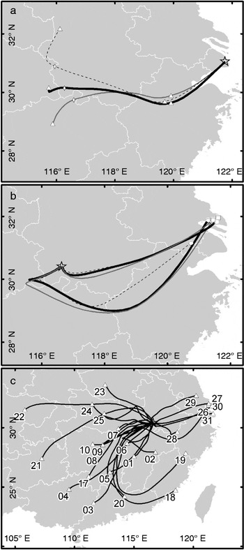
These results indicated that peaks of BPH in light traps were immigratory peaks and corresponded with the emigratory peaks from Huaining (figs 6a and 7). The backward trajectories also indicated that the source area of BPH in Nanhui was South Anhui (fig. 9a).
(a) Backward trajectories of BPH in Nanhui in 28 August, 2007; (b) forward trajectories of BPH in Huaining in 26, 27 August, 2007; (c) forward trajectories of BPH in Huaining from 17 August to 10 September (the start height was 1500 m). dashed line, 1000 m; black bold line, 1500 m; gray line, 2000 m; (a) ◊, the point at 18 h; △, the point at 6 h; (b) ○, the trajectories started at 26 August, the end of trajectories was at 4:00 28 August; □, the trajectories started at 27 August, and ended at 15:00 28 August; (c) the labels were the start dates of trajectories.

Numerous macropterous BPH had emerged and emigrated since mid-August in the single-cropping paddies in Huaining, where forward trajectories from August 17th to September 10th were calculated. The trajectories during August 26th–31st moved eastward or north-eastward to the Yangtze River Delta. For instance, there were immigration peaks of BPH in Shanghai (fig. 9b,c). In most cases, however, BPH moved to the southwest and west (fig. 9c).
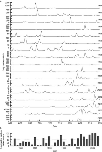
In the result obtained by Cheng et al. (Reference Cheng, Chen, Xi, Yang, Zhu, Wu, Qian and Yang1979), the planthoppers from the single-cropping rice in north of the Yangtze River started southward migration from late August, and there were some peaks of light trap catches in the Yangtze River Delta at that time. However, these peaks were different to those occurring in recent years. For these peaks, the migrants were from the north (Cheng et al., Reference Cheng, Chen, Xi, Yang, Zhu, Wu, Qian and Yang1979; Riley et al., Reference Riley, Reynolds, Smith, Rosenberg, Cheng, Zhang, Xu, Cheng, Bao, Zhai and Wang1994) and the size of catches was usually small. For example, from 1977 to 1997, there were only five years in which the size of cumulative catches in late season was more than 50% of the total catches during June 20th to September 20th in Fengxian (Shanghai Municipality), but the size of late season catches has been much larger since 1998 (fig. 10).
(a) The daily variation in the light trap catches of BPH in Fengxian (Shanghai Municipality) from 1991 to 2007. (b) The yearly variation in the percentage of late season catches (Aug.16–Sept. 20) in the total cumulative catches (Jun. 20–Sept. 20). The catches in 2005 and 2006 have been increased by 1 to avoid 0 values. The data of light trap was provided by Fengxian plant protection station.

The climate conditions and the late immigration of BPH
Transporting airflows
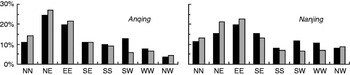
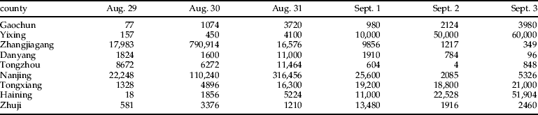
The direction of migration of BPH is predominantly determined by the wind (Riley et al., Reference Riley, Cheng, Zhang, Reynolds, Xu, Smith, Cheng, Bao and Zhai1991, Reference Riley, Reynolds, Smith, Rosenberg, Cheng, Zhang, Xu, Cheng, Bao, Zhai and Wang1994). The summer (south-west) monsoon changes over to the winter (north-east) monsoon in eastern Asia in late August and early September (Riley et al., Reference Riley, Reynolds, Smith, Rosenberg, Cheng, Zhang, Xu, Cheng, Bao, Zhai and Wang1994). In the lower-middle reaches of the Yangtze River, the north-easterlies gradually establish at this time. However, the winds change to south-westerly/westerly under the influence of subtropical anticyclones with oscillation. At the BPH flight altitude (about 850 hPa) at 20 h, the total percentages of south-westerly and westerly winds in Nanjing during 1981–2007 were, respectively, 20.4%, and 22.1% in Anqing (fig. 11). On occasions when the wind direction was from the southwest and west, BPH in single-cropping paddies in Hunan, Hubei, Jiangxi and Anhui were able to move eastward or north-eastward to the Yangtze River Delta. Some individuals are able to migrate further north, and late immigrations can occur in South Jiangsu, Shanghai, and North Zhejiang. For instance, outbreaks occurred in the Yangtze River Delta in 2005 and 2006 (figs 8, 10 and 12, table 3). However, when wind directions are mainly from the northeast or north, BPH are likely to engage in south-westward migrations. Peaks could then be expected to occur in South China, although more studies are needed to confirm that this would be the case.
The distribution of average wind directions at 850 hPa at 20 h in Anqing and Nanjing. This result based on rawinsonde observation data (1981–2007), which provided by China Meteorological Administration (CMA) (▪, 8/12–9/10;  , 9/11–9/30).

The cumulative catches of light traps per five days in counties in the Yangtze River Delta in 2005. The catches have been increased by 1 to avoid 0 values. The data of light trap were provided by Jiangsu and Zhejiang plant protection stations.

The daily light trap catches in some counties in Jiangsu and Zhejiang from August 29th to September 3rd, 2006.

Note: These data were provided by Jiangsu and Zhejiang Plant Protection Stations.
Global warming
‘Cooler summer and warmer autumn’ conditions are conducive to outbreaks of BPH in the lower-middle reaches of the Yangtze River (Pu & Chen, Reference Pu and Chen1979). Cheng et al. (Reference Cheng, Zhang, Fan and Zhu1992) analyzed the relationship between population dynamics of BPH and temperature in August to September based on the data from Jiaxing, Zhejiang Province in 1976–1988. The results indicated that temperature was one of the key factors affecting population development after immigration. High temperatures could result in longer peak periods and larger numbers of BPH. The effect of temperature in mid-September on population growth was more important than at any other time.
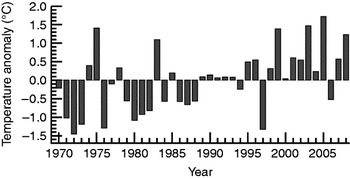
From 1970 to 1988, there were only five years (26.3%) in which the mean autumn temperature was warmer than the cumulative average for the previous 39 years (1970–2008). However, there were 17 years (85%) of warmer autumns from 1989 to 2008. Furthermore, with the exception of 2006, it has been consistently warmer in autumn since 1998. The autumn temperature in 1999 was 1.4°C higher than the average of the previous 39 years, and it was 1.5°C and 1.7°C higher in 2003 and 2005, respectively (fig. 13). Thus, it is suggested that global warming has resulted in warmer autumns from the 1990s onwards, and this has now become the norm. This recent change has been propitious for the growth of BPH populations arriving in the Yangtze River Delta through late immigration. Therefore, late immigration of BPH could threaten the late-maturing mid-season rice in Yangtze River Delta. In addition, warmer autumn conditions could also promote the growth of the BPH populations that remain locally in mixed planting areas and spread into adjacent late rice paddies.
The anomaly of the mean temperature in September in the lower-middle reaches of the Yangtze River (116–122°E, 28–33°N). This result based on NOAA's mean monthly temperatures (1970–2008), which were derived from reanalysis data.

In 2005, the mean temperature in July and August was lower than normal, and it was warmer in September and October, especially in the Yangtze River Valley in September (about 2–3°C higher). This was highly favourable for the growth of BPH populations, resulting in one more generation than usual. This was the primary cause of the outbreak of BPH in 2005 (Zhai & Cheng, Reference Zhai and Cheng2006). In the current study, a series of massive immigrations occurred from August 27th to September 3rd in 2006. For example, there were 790,000 catches by one light trap in Zhangjiagang on August 30th. However, it was continuously cool and rainy in Jiangsu during September 5–9th, and especially cool during September 4–5th in which the temperature range was 10–12°C. This continuous cool weather would have dramatically reduced BPH egg hatchability and nymph survival. The temperature anomaly of mean monthly temperatures in September was –0.52°C. Even though the temperature rose again in late September, late immigration did not cause severe damage to rice.
Discussion
There are three main elements that drive insect migration: geography, climate and host availability. The vast geographical range and active monsoons in eastern Asia are consistent from year to year. Eastern Asia, from 15 to 45°N, is a typical migration arena for insects. This area includes the Indochina Peninsula, eastern China, the Northeast Plain of China, the Korean Peninsula and Japan. This southwest-northeast region is massive in size and relatively flat with no natural barriers to insect migration. Eastern Asia is located in a monsoon zone, where winds in summer and winter are commonplace and relatively highly intense compared with elsewhere in the world. The southerly airflows in spring and summer and the northerly airflows in autumn are reported to promote the downwind displacement of insect migration (Zhang, Reference Zhang1992; Drake, Reference Drake, Drake and Gatehouse1995). However, the spatiotemporal structures of crop plantings determine host availability for agricultural migratory insects, and directly affect migration patterns and even the ebb and flow of populations. For example, outbreaks of Mythimna separata (Walker) occurred frequently in the 1970s; but with the decline of winter wheat in southern China since 1980, the overwintering area of M. separata has been greatly reduced. As a result, the occurrence of M. separata in the Jiang Huai basin (the area between Yangtze River and Huai River) has rapidly declined (Ding & Su, Reference Ding and Su2002).
Outbreaks of BPH have frequently occurred in the eastern Asia migration arena. BPH is a monophagous pest and feeds exclusively on rice. Thus, it appears that the rice cropping system restricts the distribution range and the occurrence level. BPH was a secondary pest of minor importance prior to the 1960s, until the restructuring of cropping systems in the Asian rice regions was initiated. Short-stalked, early-maturing rice varieties spread, and the planting areas of winter rice were extended in the Indochina Peninsula. As a result, BPH could breed all year round and the number of emigrants was increased. Double-cropping rice has since been extended in southern China, and single-cropping early/mid-season rice has been replaced by single-cropping late-maturing rice or double-cropping rice in the Yangtze River Valley. The long-stalked and narrow leaf rice varieties with more insect resistance have been also replaced by IR26, a short-stalked and wide leaf variety without insect resistance. All of these changes have enriched the food supply for BPH, leading to an increase in both the size of population and the number of migrants that can return to overwintering areas. The above changes in rice cropping systems throughout eastern Asia have provided a more favourable environment for the growth of BPH populations both in space and time. As a result, BPH has become one of the primary pests of irrigated rice throughout much of Asia (Li et al., Reference Li, Ding, Hu and Su1996).
In recent years, the amount of double-cropping rice planted has been greatly reduced and replaced by single-cropping rice in the lower-middle reaches of the Yangtze River. As the availability of rice begins to decline in South China, there are winds that can transport emigrating planthoppers, and there are large areas of single-cropping rice which are suitable for their continued survival and breeding when these new migrants land in the lower-middle reaches of the Yangtze River. As a consequence, the population grows quickly here and leads to mass late migration in the Yangtze River Delta. The likelihood of BPH outbreaks has been increased, and potentially disastrous population levels could occur once other conditions become favourable. Thus, the transformation of the rice cropping system can be viewed as the fundamental cause of now commonplace outbreaks of BPH in eastern Asia.
BPH population can be controlled by pesticide. Limited damage were caused by BPH in the 1990s due to the use of buprofezin and imidacloprid (Cheng et al., Reference Cheng, Wu and Ma2003), and the high level of resistance to imidacloprid resulted in chemical control failure and great yield loss in 2005 (Wang et al., Reference Wang, Gao, Zhu, Chen, Li, Zhuang, Dai, Zhou, Ma and Shen2008). Nevertheless, only large BPH populations required pesticide treatments. In addition, BPH could be resurged after chemical control because natural enemies were also decreased and even the reproduction of BPH was stimulated (Cheng et al., Reference Cheng, Wu and Ma2003). The conclusion that unsprayed, irrigated rice fields have relatively few insect pest problems was derived in tropical irrigated rice areas (Sigsgaard, Reference Sigsgaard, Toft and Scharff2002), but it was quite different in temperate region. The biodiversity is lower than in tropical regions. According to our field surveys in experimental paddies, the number of enemies, such as spiders and Cyrtorhinus lividipennis (Reuter), in the lower-middle reaches of Yangtze River was much less than that in South China. Thus, as the most effective method for controlling pests, chemical control was not the primary cause of outbreaks of BPH, at least in the lower-middle reaches of the Yangtze River.
However, location of a site in a migration arena simply indicates that that location has the potential for BPH immigration to occur at a given moment. The absolute number of immigrating insects and whether an outbreak will occur at an individual site is determined by further factors. Firstly, long range migration includes three processes: takeoff, horizontal displacement and landing. Each process will be associated with synoptic weather conditions. Therefore, not only the number of BPH emigrating from the source area, but also the weather conditions will determine the final number of insects immigrating to a given area (Chen & Cheng, Reference Chen and Cheng1980; Jiang et al., Reference Jiang, Tan, Shen, Cheng and Chen1981, Reference Jiang, Tan, Shen, Cheng and Chen1982; Kennedy, Reference Kennedy1985). Secondly, due to their population cycle of macroptery-brachyptery-macroptery, BPH usually cause significant damage after two generations. Therefore, outbreaks of BPH will not only be associated with the numbers of immigrating insects, but also with the climate and the rice growing conditions during the breeding generations.
It is obvious that temperature could regulate and control the population of BPH by direct effects on survival, reproduction and foraging, and this is known to be the most crucial factor for BPH population dynamics (Zang et al., Reference Zang, Hao, Wang and Cheng1997; Hou et al., Reference Hou, Huo, Wu, Ye, Wang, Xue and Lu2004). The population would be reduced if the temperature was higher than 33.9°C or lower than 18.6°C (Zhu et al., Reference Zhu, Lu, Hang and Xu1994). In the lower-middle reaches of the Yangtze River, a ‘cooler summer and warmer autumn’ is regarded as the favoured climatic condition for outbreaks of BPH (Pu & Chen, Reference Pu and Chen1979). For example, a typical climate of ‘cooler summer and warmer autumn’ occurred in 2005 (see ‘global warming’ section for details). The occurrence of BPH in the Yangtze River Delta in 2005 was the most serious in the past 20 years (Guo & Zhao, Reference Guo and Zhao2006; Zhai & Cheng, Reference Zhai and Cheng2006). However, the microclimate in a paddy is also distinct from the surrounding environment due to the density of rice plants. The maximum temperature in a paddy is usually 2–5°C lower than the surrounding air temperature, and the minimum temperature is usually higher by 1–2°C (Zhu et al., Reference Zhu, Lu, Hang and Xu1994). Thus, it appears that the intense heat of summer has only minimal effects on BPH populations (Gu & Xiao, Reference Gu and Xiao1993), but that ‘warmer autumn’ is the key factor. For example, it was extremely hot in Wuxian, Jiangsu Province in summer in 1990, but it was the ‘warmer autumn’ that promoted an outbreak of BPH that year (Chen et al., Reference Chen, Pan and Shen1991). As noted above, ‘warmer autumn’ conditions are occurring with greater frequency and more intensity, most probably due to global warming, and this would promote the growth of BPH populations in autumn.
Overall, the following results were obtained. (i) Since double-cropping rice has now been greatly reduced and single-cropping rice has been rapidly increasing in the mixed planting areas, the spatiotemporal dynamics and migration pattern of BPH has dramatically changed. A large number of macropterous BPH arising from single-cropping rice in mixed planting area emigrate to the Yangtze River Delta in late August and early September. (ii) Under the influence of steadily warmer autumns induced by global warming, BPH cause serious damage to late-maturing middle rice and late rice in the lower-middle reaches of the Yangtze River. It should be emphasized that these conclusions are preliminary within the consideration of systematic field investigation over a single year, thus further work need to be undertaken. Nevertheless, on the basis of three years’ light trap data and other data that served as additional evidence, these conclusions appear to be valid and provide information for forecasting and controlling BPH.
Acknowledgement
This study receives grant-aided support from: (i) National ‘973’ Program of China (2006CB102007 and 2010CB126200), (ii) Agro-Industry R&D Special Fund of China (200803003), and (iii) National Sci-Tech R&D Project of China (2006BAD08A01). We acknowledge the assistance provided by our colleagues Hui Zhang, Qihua Sun, Ranran Qin, Lili Zhou, Xigui Dong and Zhaxijiacuo, who have taken part in the field investigations in 2007. We thank the plant protection stations of Guangxi Zhuang Autonomous Region, Anhui Province, Jiangsu Province, Zhejiang Province, Shanghai City, Anqing District, Longzhou County, Huizhou County, Fengyang County and Huaining County for help with their insect survey data and light-trap catches data, and Guangxi Academy of Agricultural Sciences for their support for experiment fields.