CAPTAIN'S NAVIGATIONAL STANDING ORDERS
References:
a. Navigation Orders.
b. Company instructions for Integrated Bridge Systems.
c. International Regulations for prevention of Collision at Sea.
d. Company Fleet Instructions.
e. ICS Bridge procedures Guide.
f. Nautical Institute Bridge Team Management.
g. Admiralty Manual of Navigation Vol.1.
h. The American Practical Navigator (Bowditch).
1. PURPOSE
This instruction establishes navigation standards and procedures for the ship in an ECDIS mode of operation.
2. ACTION
All Deck Officers and cadets involved in navigating or conning the vessel are required to adhere to these standards and references (a) through (c) as well as have a thorough knowledge and understanding of references (d) through (h).
3. DISCUSSION
Navigating a ship safely requires diligent adherence to standards of accuracy and precision, especially when operating in close proximity to shallow water or land. The use of standard procedures, terminology and symbology is imperative to ensure continuity and common understanding amongst all bridge personnel.
4. NAVIGATIONAL STANDARDS:
a) Navigation will normally be conducted using the NACOS (SAM Electronics Navigation and Command System) system in ECDIS mode i.e. with ENC (Electronic Navigation Chart – vector charts), and with RCDS mode (RCDS & an appropriate folio of up to date paper charts) as the secondary mode. Back up will be paper charts. The Navigator will create passage plans for all transits using the best electronic charts available. The hierarchy of electronic chart products for the ECDIS are:
i) ENC (Vector charts)
ii) RNC (Raster Charts) i.e. UKHO ARCS charts
iii) UKHO & NOAA Paper charts
iv) Local Paper charts
b) The Navigator must authorize any changes to an active or stored passage plan. Officer of the Watch (OOW) may create and execute temporary plans when deviation from the active plan is necessary in consultation or at request of the Captain.
c) The radar overlay feature of the ECDIS is the method by which comparison of the geographical display of the vessel's position and the position of other features (fix aids, land, etc.) to the radar display is confirmed. When in RCDS mode – Map Index lines (Feature Lines on NACOS) should be used to confirm ECS accuracy – displayed on Chart/Radar – Note Radar & User Objects switched “ON”.
d) Radar Parallel Index Lines (PIs), Visual Clearing bearings and transits should still be planned and used to confirm position – these should be noted on the Arrival & Departure cards.
e) Paper charts will be available on the chart table for reference and tertiary backup. Paper charts will be corrected and marked up with a minimum of:
i) No go areas.
ii) Track lines labelled with course.
iii) P.Is.
iv) NMT/NLT Bearing lines, Clearing bearing lines, PI clearing lines Visual transits, swinging circles etc …
f) Regardless of the navigation system used, the ship will use the following hierarchy of positioning sources:
i) DGPS.
ii) GPS.
iii) Radar.
iv) Visual.
v) DR.
g) Fix intervals. The ECDIS provides virtually instantaneous position information. If neither ECDIS or RCDS mode is operational, positions will be plotted on a paper chart at the following intervals:
i) Restricted waters – 3 minutes.
ii) Pilotage waters – 6 minutes.
iii) Coastal waters – 20 minutes.
iv) Open waters – 30 minutes.
STANDARD OPERATING PROCEDURES:
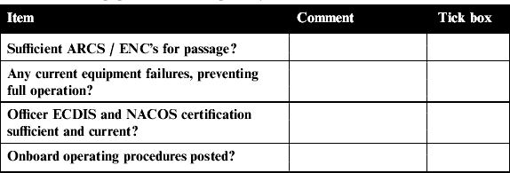
a) Risk Assessment. The ships's Risk Assessment for use of the ECDIS will be in the form of the ‘Navigators Passage Plan checklist/Navigational briefing form.’ and critical equipment failure instruction cards. By completing these we satisfy the requirements for Risk Assessment for the voyage. In the following format –
For this to be an ECDIS passage the following risk assessment needs to be completed.
If any one of the following cannot be maintained then the passage should be conducted with paper charts as the primary means.

This checklist should be completed by the Captain and First Officer. The points will be briefed when holding the formal pre-arrival and departure navigational briefing. It should be used as an aide memoire of factors to be considered for inclusion in discussions of arrival, departure or passage navigation. Amplifying information in the form of port photographs, plans, port notes, tidal curves etc should be utilised whenever possible. Navigational briefings, conducted by the Captain, should not include more than three ports in a single briefing. Briefing content and detail should depend upon many factors, including the level of familiarisation with a port of present Officer complement, and the frequency of calls. This checklist should be used by the Watch Officers conducting the passage.
b) Passage Plan. The Navigator will prepare a passage plan using the chart pilot and the best electronic charts available. Way points (WP) are to be used to indicate important time line events as well as the traditional alter course. The waypoint “Notes Area” is to be used to highlight this time line information i.e. 4' & 12' environmental discharge limits, VTS calls, speed limitations, Decision point, etc.
The OOW must acknowledge a WP and confirm the WP notes and take action as required. The hard copy of the voyage plan is to be available on the chart table and must be duly time annotated and initialled by the OOW as WPs are passed through and action confirmed. The passage plan is an integral part of the ECDIS system and must always be sighted and checked during the voyage.
Relevant navigational warnings will be inserted onto the electronic charts by means of “User Chart Objects” either Symbols/Text or both by the receiving officer. These should be referenced and time dated. Very temporary notices should be clipped onto the hard copy of the Passage Plan on the chart table and noted on watch handovers.
c) Equipment set up.
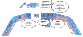
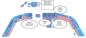
d) Responsibilities/Roles.
e) NACOS Pilot data Settings. OOW is always to be aware of the pilot data settings. These are to be discussed at watch/Con handovers. Generally the higher the speed the lower the rudder limit and more open the track limit and rudder economy. At Berth and approaching pilot stations the rudder limits should be increased and track limit reduced along with rudder economy.
Arrival/Docking Vector Length 6 Minutes
Departure/Un Docking Vectors 9 Minutes.
Path 120 Secs – (Coloured)
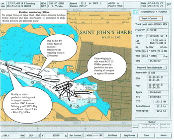
f) Position monitoring Officer ECDIS Mode. As the position of the ship is no longer being plotted on a paper chart the call out from the Position monitoring officer must change. In Figure 7 is the type of information I wish to hear – confirming that the ship is safe and what she is doing. Chose your moment to speak:
g) Pilotage. Pilots make a vital contribution to the safety of navigation in confined waters and port approaches, of which they have up-to-date knowledge; but it must be stressed that when the ship is in pilotage charge, the Captain or Officer of the Watch is not to consider himself relieved from responsibility for the safety of the ship; he must continue to pay full attention to the navigation and safe handling of the ship. Responsibility for the ship's navigation is not transferred to the pilot and the officer of the watch retains all his duties. Except whilst the ship is in transit of the Panama Canal, the Captain or Officer of the Watch is to intervene, or even take over from the Pilot, if he considers this to be necessary, in order to avoid or extricate the ship from danger. My Arrival and Departure cards are to be filled in prior to arrival and departure. These, as well as having the Capt/Pilot exchange information have important transit docking information on them.
h) Aborts and Contingencies. (Ref: N.I. BTM Page 27) When approaching constrained waters the ship may come to a position beyond which it will not be possible to do anything other than proceed, termed the ‘point of no return’. This important “DECISION POSITION” will be Way Pointed, at this WP the Captain will go around the Bridge Team and ask for a “Go – No Go” from each member – it is your duty to say if you are not confident in the ship's present position or with the planned manoeuvre. The final decision, of course, rests with the Captain. Note: The VER will record your response and my subsequent actions! This Decision Go/No Go will be based on ships position, inside (berth) winds as stated by Port Control, manoeuvring space, tug availability and any ship defects. An ABORT can be called at any point after the DECISION point by the Captain if it becomes apparent that the manoeuvre is not safe, there is more wind than forecast or the ship suffers an equipment malfunction.
i) Visual Confirmation of ECDIS. The Approach/Harbour chart will be on the forward chart table adjacent to the Gyro Compass stand to enable rapid visual fixing for “Confirmation of ECDIS” and training officers in Visual fixing techniques (Refer Admiralty Manual of Navigation Chapter 9 &13). A continuous visual fix is Not required in ECDIS mode – merely a fix by visual compass bearings or visual transit, clearing bearings to confirm the ECDIS position. The Visual Fixing Officer merely needs to state “ECDIS confirmed visually”.
j) General. (Best Practice)
• I consider 1·0 miles to be the minimum passing distance and you are to call me for a CPA of less than 1·0 mile with a CPA time of less than 20 minutes.
• If other traffic does NOT COMPLY with the Rule of the Road or you are in doubt as to their intentions and we have to take Action to avoid a Close Quarters situation – you are to call and advise me.
• Remember Rule 2. Which covers the responsibility of the master, owner and crew to comply with the rules.
(a) Nothing in these Rules shall exonerate any vessel, or the owner, master or crew thereof, from the consequences of any neglect to comply with these Rules or of the neglect of any precaution which may be required by the ordinary practice of seamen, or by the special circumstances of the case.
(b) In construing and complying with these Rules due regard shall be had to all dangers of navigation and collision and to any special circumstances, including the limitations of the vessels involved, which may make a departure from these Rules necessary to avoid immediate danger.
• Remember an early reduction of speed is always an option – and solves a situation from becoming a problem!
• I am always on call! – I always carry my bleep and am to be called as soon as you are in any doubt or think you might be! If you can not contact me by Phone/Bleep you are to broadcast for yourself twice over the Broadcast system.
• The Rudders are the main directional force of the ship. Always be aware of how they are working at sea in any wind/seaway or in pilotage in response to the ship's speed and wind/current. All Course /Helm orders are to be ‘TEAM’ acknowledged and monitored how the helm is applied. Correction of a helmsman's mistake must be quick and to order Midships and then reapply the correct helm – Preferably Calmly!
• It is navigational good practice to manually confirm/check the displayed NACOS information at least once each watch and do a manual speed check. (NACOS is only as good as the information fed into it – Check the Time Zone!)
• “A sailor is an artist whose medium is the wind” Always be aware of the weather, present and imminent. The met board is to be updated each watch and it is my wish to send as many weather observations as we can. (Captain's Barograph!)
• The JOOWs has an important “Monitoring Role” if in any doubt as to the SOOW intentions – they are REQUIRED to say so – and call me or Staff Captain if in any further doubt.
• Rule 5 requires that “every vessel shall at all times maintain a proper look-out by sight and hearing as well as by all available means appropriate in the prevailing circumstances and conditions so as to make a full appraisal of the situation and of the risk of collision.” Use of Light &Whistle signals, sound detection system and VHF, AIS, VTS are included in this.
• Keep VHF/AIS messages brief – especially with company ships – the world and the bridge VER are listening.
• SOOW to cross check and confirm all Environmental discharge limits as they occur. All e-mails to ECR are to be formal and signed by Full name and Rank. (Cadets are Not to send these important e-mails.)
• Log book entries. Include some narrative which helps when looking back for passage and port information. i.e.:
1025 Rounded Lands End and entered TSS
1100 Seven Stones Light Vessel abeam to Port
1330 Past Yacht ‘Eveready’ – 6 persons on board bound Falmouth
1500 Buzzed by Nimrod aircraft – contact made routine patrol
1600 Wind veering to North West reduces to F4
1830 Reduced to 2 Dgs Speed required now 14·5 Kts.
And in Port:
1020 – Deck 4 doors clear of quay – commence loading 50 Tonnes F&B stores
1100 – Deck 5 Gangway available
1200 – Taking on Fresh Water Rate 30T/Hour
1500 – Heavy Rain shower/Squalls Thrusters requested.
“That the log should be written in seamanlike prose / Is a rule that every seafaring man knows.
H.W.Tilman• Echo Sounder. Sensible use of the Echo Sounder alarm to purposely go off at certain depths to achieve a “Position Line” and confirmation of position/ECDIS operation. Deep Sea – crossing a bank, crossing the 100 metre line, and in Coastal waters/Pilotage for entering shallower water.
• Bridge Order Book. I consider the use of the “Bridge Diary” and my “Night Order/Arrival card” to satisfy this requirement. The card is to be kept within the diary until the morning. The Bridge Status board is also to be kept updated at all times.
“The first watch of the night passes away in worthless affairs, and the second passes in deep silence. In the third, they babble nonsense, and when the fourth watch comes, the day of death has arrived. The thought of the one who bestows body and soul never enters the mind.”
Sri Guru Granth Shaib.• Keep Professionally up to date on the latest:
◦ Company Instructional letters.
◦ Company Fleet Instructions – particularly Navigational orders.
◦ Shipping Regulations, Flag State Rules.
◦ M Notices, S.Is.
◦ MAIB reports.
◦ and the Daily News.
• Remember – Courtesy and Respect to other Depts. Be polite on the phone and keep the ECR and Hotel advised of schedule and weather changes.
• I like to operate in a relaxed but Professional atmosphere.
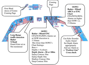
At Sea Set Up.

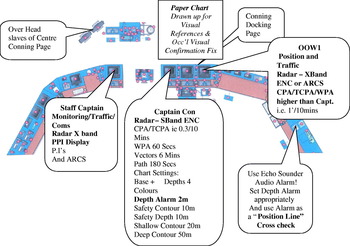
Arrival Set Up.

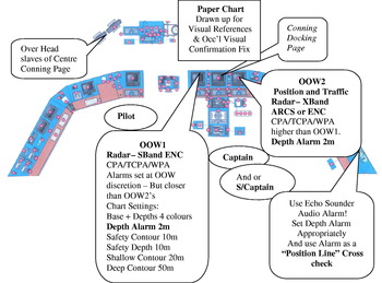
Pilotage/Transit Set Up.

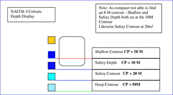
Depth display Set Up.

ECDIS – ENC Operation – Arrival.

ECDIS – No ENC – RNC Operation – Arrival.

Position Monitoring Officer.

And finally a word about Seamanship
SEAMANSHIP, in its widest sense, is the whole art of taking a ship from one place to another at sea. It is an amalgam of all the arts of designing a ship and her motive power, whether sail, steam, or other means, of working her when at sea, and in harbour, and the science of navigation by which the way is found from her point of departure to her point of arrival. It thus embraces every aspect of a ship's life in port and her progress at sea.
Seamanship, however, has also a narrower meaning, divorced from a ship's design and engines, from her navigation, and from the other specialist skills, which have their part in the smooth running of a ship. It is that department of a ship's being which is concerned with the rest of the daily management of the ship, her gear, boats, anchors and cables, rigging; her sails if she is a sailing vessel, and the watch kept at sea and in harbour. The old definition of a prime seaman was a man who could hand, reef, and steer, and although the handing and reefing of sails is largely a thing of the past so far as ships are concerned, the same general definition holds good if the modern equivalents of handing and reefing are related to the steam or motor ship of today. It embodies a knowledge of knotting and splicing, of handling ropes and hawsers, blocks and tackles, and it also embraces a knowledge of the weather and the means of competing with storms, of the rules of the road, and of lights and their meanings. Every aspect of the day-to day work of the ship is considered to be within this narrower meaning of the word.
Admiralty Manual of Seamanship, 3 vols (1964–72);