




No CrossRef data available.
ARCHAEOLOGICAL PERSPECTIVES ON CLASSIC MAYA SOCIAL ORGANIZATION FROM CARACOL, BELIZE
Published online by Cambridge University Press: 01 January 2004
Abstract
Inferring ancient social and political organization from the archaeological record is a difficult task. Generally, the models used to interpret the Classic-period Maya (a.d. 250–900) have been borrowed from other societies and other times and thus also reflect etic conceptions of the past. Maya social and political organization has been interpreted as varying in complexity. Those who would model a less complex Classic Maya social structure have tended to employ lineage models and segmentation. Models of a more complex Classic Maya civilization focus on different social levels and on a breakdown of some kinship systems. Other models, such as that of the “noble house,” represent attempts to find a middle ground. Yet archaeological and epigraphic data that have been gathered for the Classic Maya place parameters on any interpretation that is generated. Data collected from Caracol, Belize, over the past 19 years can be used to illustrate the problems that arise in the strict application of “ideal” social models to the Classic Maya situation. These same data also provide parameters for the reconstruction of ancient sociopolitical organization.
Information
- Type
- SPECIAL SECTION: NEW PERSPECTIVES ON ANCIENT LOWLAND MAYA SOCIAL ORGANIZATION
- Information
- Copyright
- © 2004 Cambridge University Press
Inferring ancient social and political systems from the archaeological record is generally a difficult task. This is clearly the case with the ancient Maya. In spite of substantial investigation and hypothesizing, no agreement exists on the nature of Classic period (a.d. 250–900) Maya social or political organization. Perhaps this is as it should be.
Scholars have viewed ancient Maya kinship and descent alternatively as patrilineal, matrilineal, and cognatic (Chase et al. 2002). They have described Maya political organization as both segmentary and centralized (Fox et al. 1996). Generally, the models used to help interpret the archaeological data are borrowed from other societies and other times. Yet archaeological data and epigraphic data gathered for the Classic Maya place constraints and boundaries on any representation.
Perhaps some of the differences among interpretations are due to differences in the archaeological database. Differences in the size of sites investigated and in the research designs of projects all potentially affect interpretations of social and political complexity. But it is also likely that variation existed among ancient Maya sites and polities and, thus, that no uniform social or political reconstruction should be expected.
CLASSIC MAYA SOCIAL AND POLITICAL ORGANIZATION: THE VIEW FROM CARACOL
Archaeological data collected from Caracol, Belize, over the past 20 years can be used to illustrate the problems that arise in the strict application of any “ideal” social models to the Classic Maya situation. These same data also provide parameters for the construction of more relevant social models. (This discussion will be limited to Late Classic [a.d. 550–900] Caracol—the time horizon of the largest occupation at the site.)
The Primacy of the Caracol Household
The archaeological research at Caracol (and elsewhere) demonstrates that the residential group constituted a basic physical and organizational feature of Classic Maya society. Characterized by both raised platforms and unraised plaza areas with one or more buildings on the various plaza sides, Caracol's residential plazas largely align with the cardinal directions, probably a distant reflection of principles still used in modern Yucatan (Watanabe 1992:65). Residential plazuela units at Caracol generally contained from four to six total buildings, although some groups contained both smaller and larger numbers. The buildings also vary in size and complexity: some are single-room perishable structures with stone foundations, while others are multi-room structures with vaulted masonry construction. Nevertheless, all these basic units seem to have functioned in similar ways.
In approximately 80% of the mapped Caracol residential groups, an eastern building functioned as a shrine (Figure 1). This building contained both honored dead and related ritual offerings. Interments were generally made in tombs (“formal constructions” or “chambers” that were “larger than necessary to hold their contents”; see A. Chase and D. Chase 1987:57 for expanded discussion of these definitions and terms), crypts (graves with “formal walls and roofs” that “are not much larger than necessary to hold their contents”), and cists (graves “with clear outlines” but without the “formal construction of either walls or roof”), although simple interments (inclusion of the body in construction fill or garbage without a formal grave) are also present. In spite of a diversity of interments, however, the limited number of burials in any one group indicates that not all the individuals who lived in the group could have been buried in these buildings. In fact, assuming that five individuals were living in any given residential building and taking into account the time depth of an excavated unit, no more than 10–20% of the population who would have lived in a given household group are reflected in burials recovered from well-excavated Classic-era residential groups (D. Chase 1997). Even if only five people lived in an entire multiple-building residential plaza group, there still are far fewer burials than former residents. At Tikal, some groups contain only males (Haviland 1988). At Santa Rita Corozal, some Late Postclassic groups are associated only with females and children (D. Chase 1982; D. Chase and A. Chase 1988). Interestingly, at Caracol individuals who were interred in these places of honor and ritual during the Late Classic period included both sexes, as well as adults and subadults.

The “Caracol Identity”: examples of typical Caracol “face caches,” of a Caracol east-focus structure group, and of tombs in an eastern building in a Caracol residential group.
More than 40% of Caracol's 259 interments contained more than one individual (D. Chase 1994, 1998; D. Chase and A. Chase 1996, 2003). The presence of multiple individuals within a single chamber in Caracol's residential groups suggests that the individuals inside tombs were not limited to the single founding individual for a particular plazuela group. In fact, the deposition of individuals in interments in eastern buildings may have been conditioned by ritual schedules rather than by individual historic death events (D. Chase and A. Chase 2002). Thus, a complicated situation can be documented archaeologically in which it is unclear what kind of ancestors were being buried in eastern buildings, especially as the deposits themselves may have been considered to be ritual offerings rather than individual-specific interments of important predecessors (see also Becker 1988, 1992, 1993; D. Chase 1988; D. Chase and A. Chase 1998; Kunen et al. 2002). Whether ancestors or offerings, interments both conditioned and were conditioned by the religious, social, and political lives of the individuals living in associated residential groups. But even if these interments related lineally to the living household, not all ancestors were interred in tombs in the eastern buildings of their residential groups: more than one ancestor could be buried in a single interment; more than one tomb could be located in the eastern shrine; and far too many mortuary structures exist in residential groups for each shrine to have housed separate lineage ancestors. If true ancestor veneration existed among the Caracoleños, these data imply that the residential group—rather than some larger unit—served as the focus for this ritual. And other community building forms are not in evidence in the Caracol landscape that could be used to suggest any particular hierarchy for venerated ancestors (as is found in Chinese society [Freedman 1966, 1970]).
Eastern buildings in plazuela groups at Caracol also yielded other ritual offerings. Caches consisted predominantly of ceramic urns with modeled faces or of lip-to-lip bowls containing the remains of human fingers (A. Chase and D. Chase 1994; D. Chase and A. Chase 1998). Limited numbers of these ritual deposits were usually placed on axis to and in front of eastern buildings in residential groups; in several documented cases, however, dozens of these containers were placed on axis to eastern buildings in front of and within stairs (Jaeger 1991). While the caches in royal or elite contexts may have been more elaborate, face caches and finger bowls were deposited throughout Caracol and in the same plazuela group locations regardless of whether the residents were of high or low status. Thus, each of the individual plazuela groups witnessed the performance of pan-Caracol ritual. Assuming that 80% of Caracol's plazuela groups participated in this kind of activity, as the archaeological data indicate, then the total number of eastern ritual buildings at the site would have numbered more than 7,000. The caching practices, like burial practices, are far too widespread to have taken place solely in households associated with a lineage head.
Besides caching practices, other indicators exist to suggest that ritual activity was uniform and widespread at Caracol. Many of these same residential groups contain the remains of modeled incensarios associated with these eastern buildings. Hourglass-shape incensarios dating from the early part of the Late Classic period have been recovered in a number of tombs from outlying residential groups. Either ceiba-tree spikes or a face representing the jaguar god of the underworld decorate these incensarios. Other plain and spiked censers come from tombs in Late Classic residential groups. During the Terminal Classic era, a number of cylindrical and flanged incense burners—again modeled with the face of a large jaguar god of the underworld—were left on the stairs of eastern buildings or were buried beneath their lower steps. Thus, throughout the Late Classic era it appears that Caracol's residential groups participated in religious rituals that were often restricted to epicentral locales at many other sites (Rice 1999).
Besides mortuary and religious ritual, other activities occurred within the Caracol residential groups. Each residential group appears to have had at least one economic specialization, and neighboring groups often had different specialties. Individual groups focused primarily on bone, shell, wood, or stone tool production. Agricultural production at Caracol also was conducted in terraced fields adjacent to plazuela groups. A consideration of settlement survey suggests that each residential group had access to approximately 2.5 ha of land. While great independence existed relative to the production of goods at each Caracol residence, we believe that the areas for the distribution of the manufactured objects were tightly controlled allocation points in the open non-residential plaza areas associated with the Caracol causeway termini, probably utilized in a system of solar markets (A. Chase and D. Chase 2001a). Classic-era Caracol, with its vast system of dendritic causeways linking all of the large termini plazas directly to the site epicenter, would have functioned as an administered economy in which distribution was tightly controlled while production continued unabated at the household level (see A. Chase 1998). As at Tikal (Haviland 1974, but see Moholy-Nagy 1997), no indication of attached specialists (or even artisans located in the immediate proximity to elite residences) exists, as is suggested for some sites (such as Copan).
It is not clear how many people lived in each residential plazuela group. If one removes the eastern ritual building from the sample and assumes five people per building in a plazuela group (provided that each building within a plazuela group was a residence for either separate families or for an extended family), the average residential group would have housed between 15 and 25 people. But, as indicated earlier, a few groups had fewer buildings, and a number had more buildings (and/or buildings with multiple rooms). Thus, some households could have been substantially larger or smaller. This estimate for residential group size compares to ethnographic and ethnohistoric data that range in number from fewer than five (Haviland 1972) to more than 40 (Hellmuth 1977) people in a single household. Matthew Restall (1997:100) indicated that generally 6–12 members of an extended family lived in sixteenth-century households in Yucatan. But testament data suggested that this family would have lived in a solar or house lot containing only two buildings (Restall 1997:105–6). Restall noted that there may have been other perishable buildings not mentioned for the purposes of inheritance; however, the smaller number of structures indicated in his data suggests that the ancient residential group, with its larger number of buildings, may have been bigger. In contrast to the archaeology and to information in central Mexican documents, Restall's data (1997:106) do not indicate separate ritual or storage buildings as existing within Maya residential groups, suggesting potential changes in the function of individual structures and/or the residential group from the Classic era to Historic times. Thus, the archaeological estimates of 15–25 people based on structure numbers may well be correct.
Skeletal data (and genetically determined traits) from burials can be used to suggest that people living in an archaeological residential group were likely related to each other. In some cases, sequent burials placed within the same building and separated by some period of time show similar skeletal anomalies, such as the presence of an extra incisor, which are presumably linked genetically (A. Chase 1983; D. Chase 1997). At Caracol, reconstruction of diet based on stable isotope analysis suggests that individuals buried within a single interment or within a single residential group ate their meals together. However, dietary analysis of individuals in neighboring groups indicates that neighbors often consumed very distinctive diets. Variation in protein and maize consumption supports the idea that neighboring groups may not have been closely related in terms of kinship (D. Chase et al. 1998; A. Chase et al. 2001). Only very rarely at Caracol do we find clustering or nesting of residential groups, as would be expected from the natural fissioning of household growth in which related kin would have sought to live near one another. Once households grew to sufficient size to require fissioning, new plazuela groups established themselves elsewhere. Given the regularly spaced dense settlement and ubiquitous terracing that occurs within Caracol's landscape, these fissioned households would have had to establish themselves on the margins of Caracol's settlement, if only because no available localized space existed within the site's established field systems. It should be noted that these archaeological data do not automatically indicate a preference for the use of any specific kinship or descent system by the ancient Maya (A. Chase et al. 2002).
Beyond the Household: The Caracol Community
A pan-Caracol identity characterized the broader Caracol community. The identity is evident in ritual caches; in the burial of the dead; and in the generalized use, construction, and layout of residential plazuela groups. This observation conforms with various descriptions of Maya communities, including Joyce Marcus's (1983) view of the city as focal and unifying and Restall's (1997:13–19) ethnohistoric description of cah as a geographical community potentially similar to the Nahua altepetl. The community identity surely extended for a distance beyond the city itself into the heart of the area over which Caracol had social and political control during the seventh and eighth centuries. For example, the apparent abundance of eastern shrines in the southeastern Peten of Guatemala may be interpreted as demonstrating this area's close linkage with Caracol (A. Chase 2004).
Of greater difficulty to discern are units smaller than the city or polity but larger than the residential group. Archaeologists have attempted to find divisions in sites—calling them barrios or sectors—and have defined them based on a variety of factors. For Late Postclassic Santa Rita Corozal in northern Belize, distinctive cache offerings and the distribution of certain building types can be used to segment the site. In particular, multiroom structures were not concentrated in one specific area of the site (as they were at coeval Mayapan farther to the north); rather, this distinctive building type appeared in a dispersed distribution scattered throughout the Late Postclassic settlement. However, these structures could also be correlated with distinct ritual (katun idols; alcohol consumption) and administrative functions (audience halls) that would have been important for town leaders. In addition, the Late Postclassic caching patterns found within the extended areas of each of the recognized multiroom structures varied stylistically from each other. Thus, the distribution of this structural type and the differences in caching patterns effectively segment Late Postclassic Santa Rita Corozal into smaller divisions (D. Chase 1982, 1986).
Other models for subdividing Maya towns and polities derive from ethnohistoric and epigraphic data. Ralph Roys (1972 [1943]:11) suggested that the Maya had both subdivisions of a town and larger recognized districts, as indicated through the use of terms such as cuchteel and cuchcabal. But other researchers have found that these terms had quite varied meanings (Restall 1997: 24–25, 27).
That material reveals the cah as the sole central and indisputable unit of Maya sociopolitics, but it provides no direct evidence either of the macrounits that supposedly existed before the conquest or the subunits of the cah that supposedly existed before the conquest or of the subunits of the cah that supposedly existed until the seventeenth century. (Restall 1997:25)
Epigraphic interpretation sometimes claims smaller social or political divisions than those seen on the level of the emblem glyph (Mathews 1991). Linda Schele and Peter Mathews (1998:23) have argued that political divisions of a single polity are sometimes reflected within the hieroglyphs, specifically arguing that the broader Tikal polity was composed of 13 distinct divisions. Such divisions would have been distinct from the named places also found in hieroglyphic texts (e.g. Stuart and Houston 1994).
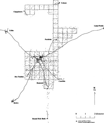
Settlement study at Caracol clearly shows the layout of the ancient city and provides a sense of the relationships among residential groups (Figure 2). Caching patterns and the use of eastern buildings for burials are pan-Caracol patterns with no clear evidence for subset groupings such as barrios or sectors. But variation in status apparently occurs within certain settlement areas. High-status elite and royal households can be located in Caracol's epicentral palaces. The most massive architectural construction at the site, Caana, is likely to have functioned as the royal household for Caracol's ruler (A. Chase and D. Chase 2001b). High-status elite palaces also occur at some of the site's causeway termini (Figure 2). Selected plazuela groups in other locations (such as the residential group at the end of the Machete Causeway spur off the Conchita Causeway in southeast Caracol) also housed high-status elite. These high-status groups are associated with eastern buildings (or temples in a few cases) that contain tombs with painted linear decoration and texts. Dates associated with these tombs presumably represent either chamber consecration or an individual's death date (e.g., D. Chase and A. Chase 1996). The high status of these painted chambers finds confirmation in the use of the Caracol emblem glyph in one of the associated texts (A. Chase and D. Chase 1987). Other artifacts, such as jadeite earflares, also occur in the painted epicentral tombs and may be correlated with extremely high status (D. Chase 1998).

Site map of Caracol, Belize, at the end of the 2000 field season. Squares are 500 m × 500 m and represent fully mapped grids; diagonal lines are causeways.
Combining settlement data with diet leads to other interesting correlations of status variation. Stable isotope analysis indicates that individuals of highest status (those who lived in the palaces) maintained a distinctive diet that was high in both maize and protein. Closest to this diet were individuals interred in large raised residential plazas adjacent to causeway termini. Farthest from this diet, and low in maize and protein, were individuals buried in residential groups immediately surrounding the epicenter (A. Chase et al. 2001). The majority of Caracol's inhabitants, however, had an intermediate, but generally good, diet. Thus, the settlement and dietary data suggest a situation more closely representing Ernest Burgess's (1967 [1923]) concentric model describing a twentieth-century city. This prompts serious consideration of whether some of the models used to describe the ancient Maya might also not be better derived from more modern urban contexts rather than from simpler, largely kinship-based, communities.
To summarize, investigations at Caracol, Belize, provide some insight into the nature of ancient Maya social and political organization. The Late Classic Maya of Caracol maintained a basic social unit of the residence in a single plazuela group. We suggest that this group represented an extended family ranging from five to substantially more than 40 individuals, but probably most often with between 15 and 25 family members. These people lived and ate together. They also appear to have formed a corporate unit for economic purposes. The overall Caracol community maintained its own distinctive social identity during the Late Classic period (A. Chase and D. Chase 1996a). While subdivisions are likely to have occurred among the population at this time, the recovered archaeological record reveals combined status, dietary, and settlement differences. Royal individuals mostly lived in palaces in the epicenter. Support populations, probably without access to agricultural land, lived in a surrounding ring of settlement immediately adjacent to Caracol's downtown area. Beyond this small epicentral ring, a larger area of core settlement included varied status levels in immediate proximity to each other. Each of these residential plazuela units appears to have been situated contiguous to 2.5 ha of agricultural land.
Most outlying plaza groups tended to focus on a single economic activity, often related to woodworking or bone-working, but also including shell and lithic tool production; individuals in many residential groups also probably spun cloth. The finished goods produced in these residential groups were ostensibly traded for other goods, such as ceramics, at solar marketplaces presumably formed by many of Caracol's public termini groups. While production remained independent, the distribution of the finished goods would have been controlled by the site's elite at these market locales. Apparently, no specialists were attached to palaces; rather, economic production was again localized, as in the outlying plaza groups. But individuals within the palaces, presumably part of the extended royal household, are known to have worked shell and bone and probably to have spun cloth. Thus, the palace occupants alone participated in Caracol's administered economy as both producers and distributors.
The Caracol site plan provides no indication of new housing for family members in a contiguous nested housing arrangement. Rather, individual residences appear to have expanded the number of structures in the same plazuela arrangement, or, alternatively, groups fissioned, with newer residences, of necessity, being placed at the outskirts of the Caracol metropolitan zone in areas not yet filled with settlement and fields.
Lineages or chibals, while noted in the ethnohistoric materials (e.g., McAnany 1995), cannot be found in the Caracol archaeological record. The site's single-extended-family residential focus, settlement patterns, and status distributions suggest a similarity to certain contemporary or historic urban situations (Burgess 1967 [1923]). An edge-city model has in fact been suggested as providing some utility in attempting to understand the growth of ancient Caracol's economic, communication, and transportation systems (A. Chase et al. 2001; Garreau 1991).
Deranging Factors in Settlement Models
The ease in seeing Maya plazuela groups in the archaeological record has led to an emphasis on the household in settlement archaeology (Wilk and Ashmore 1988). And while a focus on the house or residence should clearly be key in investigations of the ancient Maya, this focus should not be confused with a more abstract “house model.” The sheer numbers of easily identifiable residential units at Maya sites might cause some to think that a house model or noble-house model (Gillespie 2000; Lévi-Strauss 1982) could have direct applicability for the ancient Maya and prove useful in making interpretations about the Maya past. This model, however, has been expanded to include a wide variety of social and political structures (Block 1995:71; Carsten and Hugh-Jones 1995; Waterson 1995:67), and it cannot be expected to reconstruct and differentiate ancient Maya sociopolitical structure.
The wards or barrios and the houses of the principales described by Landa (Tozzer 1941) finds potential archaeological support in Late Postclassic sites such as Santa Rita Corozal and Mayapan (as indicated by caching patterns and structure distribution of multiple room buildings and/or colonnaded halls). Some of the architectural forms found at these two sites may be similar to the Nahua calpolli, or “big house.” This organizational resemblance may be due to the closer temporal relationship between the Postclassic and Historic periods. Alternatively, what appear as historic parallels possibly may have arisen due to Spanish familiarity with Nahua practices or as outgrowths of early sixteenth-century Spanish–Maya interactions. Regardless of similarity, however, such architectural features do not go back in time to the Classic period at Caracol, as these building forms (or their analogs) do not appear in the archaeological record. The palaces recorded for most major Maya sites in the southern lowlands (Andrews 1975; Inomata and Houston 2001) appear to have combined residential and administrative functions. Only at some sites in the northern lowlands can potential Late Classic antecedents to the “big house” be found, such as Structure 424 at Edzna or Structure 44 at Dzibilchaltun (Arnauld 2001).
It is inappropriate to assume the existence of one monolithic organizational system for the Classic Maya, as great variation is found in the layouts and archaeological records of Maya sites. For example, east-focused residential groups have been examined at both Tikal and Caracol. At Tikal, east-focused groups, referred to as “Plaza Plan 2” groups, occur in barely over 14% of the mapped groups (Becker 1982:120, 2003:259); at Caracol, some 80% of the groups are east-focused. At Caracol, specialized cache containers and tombs occur within most east-focused groups; at Tikal, they do not (e.g. Becker and Jones 1999). These site-by-site differences are clearly significant. Thus, we must look at a continuum of settlements to understand best Late Classic Maya social and political organization. Within this continuum, Caracol is clearly one apex and thus not likely to be characteristic of all Maya sites. Similar variability has been noted for central Mexico, where John Chance (2000:498) and James Lockhart (1992: 104) suggested that at least two variant principles of organization existed among the Contact-period Nahua. Roys (1957, 1972 [1943]), in fact, long ago suggested that minimally three variant political organizations existed for the Contact-period Maya. Perhaps the reason that organizational terms beyond cah do not appear to be uniformly defined or employed by modern populations (Restall 1997:24–25) is that the ancient Maya used variant, as opposed to uniform, social and political forms.
CONCLUSIONS
For the Classic-period Maya, the models that have been used as frameworks for structuring their presumed past social and political organization often tend to reflect etic conceptions of the past taken from multiple non–Maya contexts. In particular, modeling a less complex Classic Maya social structure has tended to employ reference frames focusing on lineage and segmentation. Models of a more complex Classic Maya focus on the intricacies of the archaeological data and have examined different social levels as well as a postulated breakdown of some kinship systems in the Late Classic period. While the “noble house” model (Gillespie 2000) attempts to find middle ground between the archaeological interpretations and the ethnographic possibilities, to a large extent it resurrects an earlier “feudal model” (Adams and Smith 1981) of sociopolitical organization. Rarely dealt with in all of this discussion, however, is the issue that different researchers can maintain completely opposing views of social and political complexity using what would appear to be very similar basic data. To us, this suggests either that inappropriate questions are being asked of the accumulated archaeological data or that the data are simply being fitted to pre-existing models, with some data subsets potentially being ignored. Yet another possibility is that differing research designs and methodologies are directly affecting our interpretations.
Archaeological data do provide detailed information about ancient Classic Maya social and political organization. The Caracol data suggest that models based on low levels of stratification and hierarchy (such as the segmentary state) are probably not applicable—at least, at Caracol (A. Chase 1992; A. Chase and D. Chase 1992, 1996b; D. Chase and A. Chase 1992). It has been suggested that more recent models employed by urban theorists, such as the “edge-city” model, may help explain Caracol's physical layout (A. Chase et al. 2001). Models that fit multiple sociopolitical situations, such as the “house” model, perhaps are valuable in shifting the focus of archaeological investigations, but because such models encompass a broad range of societies (as clearly noted in the ethnographic literature [Block 1995:71; Waterson 1995:67]), they cannot be expected to help differentiate ancient Maya social and political structures.
We have suggested (A. Chase et al. 2002; D. Chase et al. 1990) that some of the differences among interpretations are due to differences in the archaeological database. Sites such as Caracol and Tikal are larger than many other Classic-period sites and probably represented variant solutions to organizational problems and principles. To gain an understanding of the ancient Maya, however, we cannot simply look at small or large sites. We must view the “continuum” ( A. Chase 2004). Equally important are research designs, investigation methodology, and scale of operation. These affect researchers' ability to both sample and compare the full range of structures, plaza groups, and associated use-related and ritual deposits. When the multiplicity of forms and scales is taken into account, it becomes evident that extensive variation exists not only within any given site but also among the sites that made up the patchwork of ancient Maya social and political units across time and space. One static situation does not exist. This is evident in Roys's (1957) interpretation of multiple political systems for the Late Postclassic era and in Marcus's (1983, 1993) restatement of this idea for the Classic period emphasizing the constant cyclical change of social and political structures. It is also evident in Restall's (1997) difficulty in clearly and unambiguously finding definitive terms for variant social and political structures. It is furthermore apparent in the diversity easily viewed in the composition and layout among Classic-period sites, as well as in the differing opinions of researchers with regard to the appropriate social and political models.
Archaeological data provide substantial information relative to ancient Maya sociopolitical organization, especially when critically conjoined with ethnohistoric information and with comparisons to the history and archaeology elsewhere in Mesoamerica. These data make it clear that multiple kinds of cities and polities existed in the Late Classic Maya world and that simple “one-size-fits-all” models paint the picture of the past with a far bigger and wider brush than necessary or possible. Rather than arguing over the applicability of borrowed models for Classic-period Maya kinship, social, and political organization, what we need is the systematic long-term collection and analyses of archaeological data relevant to resolving some of these long-standing issues.
RESUMEN
El tratar de deducir la organización sociopolítica de un pueblo de antaño, usando como base el expediente arqueológico es una tarea difícil de llevar a cabo. Generalmente, los modelos usados para interpretar el período clásico maya (250–900 d.C.) han sido obtenidos de otras sociedades y de otros tiempos y por lo tanto, reflejan los conceptos etic del pasado. El grado de complejidad de la organización sociopolítica de los mayas ha sido interpretado de diferentes maneras. Aquellos que arguyen un modelo menos complejo tocante a la estructura sociopolítica del período clásico maya tienden a emplear modelos basados en el linaje y la segmentación. Aquellos que arguyen por una estructura social más compleja del período clásico maya se concentran en enfocar los diferentes niveles sociales y la desintegración de la estructura del parentesco. Otros modelos, tales como el de la “casa noble,” representan un término medio. Sin embargo, datos arquelógicos y epigráficos que se han logrado obtener del período clásico maya, imponen ciertos parámetros a cualquier interpretación que se genere. Los datos obtenidos en Caracol, Belice, en los últimos 19 años pueden ser usados para ilustrar los problemas que pueden presentarse al usar una explicación estricta y terminante de los modelos sociales “ideales” del período clásico maya. Estos mismos datos también proporcionan parámetros para la reconstrucción de la organización sociopolítica antigua.
ACKNOWLEDGMENTS
An earlier version of this paper was presented at the 100th Annual Meeting of the American Anthropological Association, December 2001, Washington, DC. The authors thank William Fowler, William Haviland, Joyce Marcus, and Hattula Moholy-Nagy for their helpful comments on a subsequent version of this paper. José Fernandez was kind enough to translate the abstract into Spanish. The work reported on here was supported by grants from the National Science Foundation (1994–1996 [SBR-9311773], 1997–1998 [SBR-9708637], 2001–2004 [DBI-0115837]), as well as the Ahau Foundation (1997–2003), the Dart Foundation (1996), the Foundation for the Advancement of Mesoamerican Studies, Inc. (1997), the Stans Foundation (1997–2003), and the Trevor Colbourn Endowment of the University of Central Florida (1997–2003). The aid and assistance of the Government of Belize and the former Department of Archaeology (Ministry of Tourism) is also gratefully acknowledged.
References
REFERENCES
Adams, Richard E.W., and
Woodruff D. Smith
1981
Feudal Models for Classic Maya Civilization. In
Lowland Maya Settlement Patterns, edited by
Wendy Ashmore, pp.
335–349.
University of New Mexico Press,
Albuquerque.
Andrews, George F.
1975
Maya Cities: Placemaking and Urbanism.
University of Oklahoma Press,
Norman.
Arnauld, Marie Charlotte
2001
La “Casa Grande”: Evolución de la arquitectura
del poder del clásico al postclásico. In
Reconstruyendo la ciudad maya: El urbanismo en las sociedades
antiguas, edited by
Andrés Ciudad Ruiz,
Maria Josefa Iglesias Ponce de Leon, and
Maria Carmen Martínez Martinez,
pp.
363–401.
Sociedad Española de Estudios Mayas,
Madrid.
Becker, Marshall J.
1982
Ancient Maya Houses and Their Identification: An Evaluation of
Architectural Groups at Tikal and Inferences Regarding Their
Function.
Revista española de antropología americana
12:11–129.Google Scholar
Becker, Marshall J.
1988
Caches as Burials, Burials as Caches: The Meaning of Ritual
Deposits Among the Classic Period Lowland Maya. In
Recent Studies in Pre-Columbian Archaeology, edited by
Nicholas Saunders and
Oliver de Montmollin, pp.
117–142.
BAR International Series 421.
British Archaeological Reports,
Oxford.
Becker, Marshall J.
1992
Burials as Caches; Caches as Burials: A New Interpretation of the
Meaning of Ritual Deposits Among the Classic Period Lowland Maya. In
New Theories on the Ancient Maya, edited by
Elin C. Danien and
Robert J. Sharer, pp.
185–196.
University Museum Monograph 77.
University of Pennsylvania,
Philadelphia.
Becker, Marshall J.
1993
Earth Offering Among the Classic Period Lowland Maya: Burials and
Caches as Ritual Deposits. In
Perspectivas antropológicas en el mundo maya, edited by
Maria Josefa Iglesias Ponce de Leon and
Francesc Ligorred Perramon, pp.
45–74.
Publicaciones de la SEEM No. 2.
Sociedad Española de Estudios Mayas,
Madrid.
Becker, Marshall J.
2003
Plaza Plans at Tikal: A Research Strategy for Inferring Social
Organization and Processes of Culture Change at Lowland Maya
Sites. In
Tikal: Dynasties, Foreigners, and Affairs of State: Advancing Maya
Archaeology, edited by
Jeremy A. Sabloff, pp.
253–280.
School of American Research Press,
Santa Fe, NM.
Becker, Marshall J., and
Christopher Jones
1999
Excavations in Residential Areas of Tikal: Groups with Shrines.
Tikal Report 21. Monograph 104.
University Museum Publications, University of Pennsylvania,
Philadelphia.
Block, Maurice
1995
The Resurrection of the House Amongst the Zafimaniry of
Madagascar. In
About the House: Lévi-Strauss and Beyond, edited by
Janet Carsten and
Stephen Hugh-Jones, pp.
69–83.
Cambridge University Press,
Cambridge, UK.
Burgess, Ernest W.
1967 [1923]
The Growth of the City: An Introduction to a
Research Project. In
The City, edited by
Robert E. Park,
Ernest W. Burgess, and
Roderick D. McKenzie, pp.
47–62.
University of Chicago Press,
Chicago.
Carsten, Janet, and
Stephen Hugh-Jones (editors)
1995
About the House: Lévi-Strauss and Beyond.
Cambridge University Press,
Cambridge, UK.
Chance, John
2000
Descent and the Nahua Noble House.
American Anthropologist
102(3):485–503.Google Scholar
Chase, Arlen F.
1983
A Contextual Consideration of the Tayasal-Paxcaman Zone, El Peten,
Guatemala.
Unpublished Ph.D. dissertation,
Department of Anthropology, University of Pennsylvania,
Philadelphia.
Chase, Arlen F.
1992
Elites and the Changing Organization of Classic Maya Society. In
Mesoamerican Elites: An Archaeological Assessment, edited by
Diane Z. Chase and
Arlen F. Chase, pp.
30–49.
University of Oklahoma Press,
Norman.
Chase, Arlen F.
1998
Planeación cívica e integración de sitio en
Caracol, Belice: Definiendo una economía administrada del
periodo clásico maya.
Los investigadores de la cultura maya
6(1):26–44.Google Scholar
Chase, Arlen F.
2004
Polities, Politics, and Social Dynamics:
“Contextualizing” the Archaeology of the Belize Valley and
Caracol. In
The Ancient Maya of the Belize Valley: Half a Century of
Archaeological Research, edited by
James F. Garber, pp.
320–334.
University Press of Florida,
Gainesville.
Chase, Arlen F., and
Diane Z. Chase
1987
Investigations at the Classic Maya City of Caracol, Belize:
1985–1987.
Pre-Columbian Art Research Institute Monograph 3.
San Francisco.
Chase, Arlen F., and
Diane Z. Chase
1992
Mesoamerican Elites: Assumptions, Definitions, and Models. In
Mesoamerican Elites: An Archaeological Assessment, edited by
Diane Z. Chase and
Arlen F. Chase, pp.
3–17.
University of Oklahoma Press,
Norman.
Chase, Arlen F., and
Diane Z. Chase
1994
Maya Veneration of the Dead at Caracol, Belize. In
Seventh Palenque Round Table, 1989, edited by
Merle G. Robertson and
Virginia M. Fields, pp.
55–62.
Pre-Columbian Art Research Institute,
San Francisco.
Chase, Arlen F., and
Diane Z. Chase
1996a
A Mighty Maya Nation: How Caracol Built an Empire by Cultivating
Its Middle Class.
Archaeology
49(5):66–72.Google Scholar
Chase, Arlen F., and
Diane Z. Chase
1996b
More Than Kin and King: Centralized Political Organization Among
the Ancient Maya.
Current Anthropology
37(5):803–810.Google Scholar
Chase, Arlen F., and
Diane Z. Chase
2001a
Ancient Maya Causeways and Site Organization at Caracol, Belize.
Ancient Mesoamerica
12:1–9.Google Scholar
Chase, Arlen F., and
Diane Z. Chase
2001b
The Royal Court of Caracol, Belize: Its Palaces and People. In
Royal Courts of the Ancient Maya, Volume 2: Data and Case Studies,
edited by
Takeshi Inomata and
Stephen D. Houston, pp.
102–137.
Westview Press,
Boulder, CO.
Chase, Arlen F.,
Diane Z. Chase, and
William A. Haviland
2002
Maya Social Organization from a Big Site Perspective: Classic
Period Caracol, Belize and Tikal, Guatemala. In
Organización social maya: 1999 Palenque Mesa Redonda,
edited by
Vera Tiestler,
Rafael Cobos, and
Merle Greene,
pp.
251–276.
Instituto Nacional de Arqueología e Historia,
Mexico City.
Chase, Arlen F.,
Diane Z. Chase, and
Christine White
2001
El paisaje urbano maya: La integración de los rspacios
construidos y la estructura social en Caracol, Belice. In
Reconstruyendo la ciudad maya: El urbanismo en las sociedades
antiguas, edited by
Andrés Ciudad Ruiz,
Maria Josefa Iglesias Ponce de Leon, and
M. Carmen Martínez Martínez,
pp.
95–122.
Sociedad Española de Estudios Mayas,
Madrid.
Chase, Diane Z.
1982
Spatial and Temporal Variability in Postclassic Northern Belize.
Unpublished Ph.D. dissertation,
Department of Anthropology, University of Pennsylvania,
Philadelphia.
Chase, Diane Z.
1986
Social and Political Organization in the Land of Cacao and Honey:
Correlating the Archaeology and Ethnohistory of the Postclassic Lowland
Maya. In
Late Lowland Maya Civilization: Classic to Postclassic, edited by
Jeremy A. Sabloff and
E. Wyllys Andrews V, pp.
347–377.
University of New Mexico Press,
Albuquerque.
Chase, Diane Z.
1988
Caches and Censerwares: Meaning from Maya Pottery. In
A Pot for All Reasons: Ceramic Ecology Revisited, edited by
Louana Lackey and
Charles Kolb, pp.
81–104.
Laboratory of Anthropology,
Temple University, Philadelphia.
Chase, Diane Z.
1994
Human Osteology, Pathology, and Demography as Represented in the
Burials of Caracol, Belize. In
Studies in the Archaeology of Caracol, Belize, edited by
Diane Z. Chase and
Arlen F. Chase, pp.
123–138.
Pre-Columbian Art Research Institute Monograph 7.
San Francisco.
Chase, Diane Z.
1997
Southern Lowland Maya Archaeology and Human Skeletal Remains:
Interpretations from Caracol (Belize), Santa Rita Corozal (Belize), and
Tayasal (Guatemala). In
Bones of the Maya: Studies of Ancient Skeletons, edited by
Stephen C. Whittington and
David M. Reed, pp.
15–27.
Smithsonian Institution Press,
Washington, DC.
Chase, Diane Z.
1998
Albergando a los muertos en Caracol, Belice.
Los investigadores de la cultura maya
6(1):9–25.Google Scholar
Chase, Diane Z., and
Arlen F. Chase
1988
A Postclassic Perspective: Excavations at the Maya Site of Santa
Rita Corozal, Belize.
Pre-Columbian Art Research Institute Monograph 4.
San Francisco.
Chase, Diane Z., and
Arlen F. Chase
1992
An Archaeological Assessment of Mesoamerican Elites. In
Mesoamerican Elites: An Archaeological Assessment, edited by
Diane Z. Chase and
Arlen F. Chase, pp.
303–317.
University of Oklahoma Press,
Norman.
Chase, Diane Z., and
Arlen F. Chase
1996
Maya Multiples: Individuals, Entries, and Tombs in Structure A34 of
Caracol, Belize.
Latin American Antiquity
7(1):61–79.Google Scholar
Chase, Diane Z., and
Arlen F. Chase
1998
The Architectural Context of Caches, Burials, and Other Ritual
Activities for the Classic Period Maya (as Reflected at Caracol,
Belize). In
Function and Meaning in Classic Maya Architecture, edited by
Stephen D. Houston, pp.
299–332,
Dumbarton Oaks,
Washington, DC.
Chase, Diane Z., and
Arlen F. Chase
2002
Patrones de enterramiento y ciclos residenciales en Caracol,
Belice.
Paper presented at the IV Mesa Redonda de Palenque,
Palenque, Mexico.
Chase, Diane Z., and
Arlen F. Chase
2003
Secular, sagrado, y revisitado: La profanación,
alteración, y reconsagración de los antiguos entierros
mayas. In
Antropología de la eternidad: La muerte en la cultura maya,
edited by
Andrés Ciudad Ruiz,
Maria Luz Sosa, and
Maria Josefa Iglesias Ponce de Leon,
pp.
255–277.
Publicaciones de la SEEM No. 7.
Sociedad de los Estudios Mayas,
Madrid.
Chase, Diane Z.,
Arlen F. Chase, and
William A. Haviland
1990
The Classic Maya City: Reconsidering “The Mesoamerican Urban
Tradition.”
American Anthropologist
92:499–506.Google Scholar
Chase, Diane Z.,
Arlen F. Chase,
Christine White, and
Wendy Giddens (Teeter)
1998
Human Skeletal Remains in Archaeological Context: Status, Diet, and
Household at Caracol, Belize.
Paper presented at the 14th International Congress of
Anthropological and Ethnological Sciences,
Williamsburg, VA.
Fox, John,
Scott Cook,
Arlen F. Chase, and
Diane Z. Chase
1996
Questions of Political and Economic Integration: Segmentary Versus
Centralized States Among the Ancient Maya.
Current Anthropology
37(5):795–801Google Scholar
Freedman, Maurice
1966
Chinese Lineage and Society: Fukien and Kwangtung.
London School of Economics Monographs on Social Anthropology
33.
Althone Press,
New York.
Freedman, Maurice
1970
Ritual Aspects of Chinese Kinship and Marriage. In
Family and Kinship in Chinese Society, edited by
Maurice Freedman.
Stanford University Press,
Stanford, CA.
Garreau, Joel
1991
Edge City: Life on the New Frontier.
Doubleday,
New York.
Gillespie, Susan D.
2000
Rethinking Ancient Maya Social Organization: Replacing
“Lineage” with “House.”
American Anthropologist
102(3):467–484.Google Scholar
Haviland, William A.
1972
Family Size, Prehistoric Population Estimates and the Ancient Maya.
American Antiquity
37:135–137.Google Scholar
Haviland, William A.
1974
Occupational Specialization at Tikal, Guatemala: Stone
Working–Monument Carving.
American Antiquity
37:135–137.Google Scholar
Haviland, William A.
1988
Muscial Hammocks at Tikal: Problems with Reconstructing Household
Composition. In
Household and Community in the Mesoamerican Past, edited by
Richard R. Wilk and
Wendy Ashmore, pp.
121–134.
University of New Mexico Press,
Albuquerque.
Hellmuth, Nicholas
1977
Cholti-Lacandon (Chiapas) and Peten-Ytza Agriculture, Settlement
Pattern, and Population. In
Social Process in Maya Prehistory, edited by
Norman Hammond, pp.
421–448.
Academic Press,
London.
Inomata, Takeshi, and
Stephen D. Houston
2001
Royal Courts of the Ancient Maya, Volume Two: Data and Case
Studies.
Westview Press,
Boulder, CO.
Jaeger, Susan
1991
Settlement Pattern Research at Caracol, Belize: The Social
Organization in a Classic Maya Center.
Unpublished Ph.D. dissertation,
Department of Anthropology, Southern Methodist University,
Dallas.
Kunen, Julie L.,
Mary Jo Galindo, and
Erin Chase
2002
Pits and Bones: Identifying Maya Ritual Behavior in the
Archaeological Record.
Ancient Mesoamerica
13:197–211.Google Scholar
Lévi-Strauss, Claude
1982
The Way of the Masks.
Translated by Sylvia Modelski.
University of Washington Press,
Seattle.
Lockhart, James
1992
The Nahuas After the Conquest: A Social and Cultural History of the
Indians of Central Mexico, Sixteenth Through Eighteenth Centuries.
Stanford University Press,
Stanford, CA.
Marcus, Joyce
1983
On the Nature of the Mesoamerican City. In
Prehistoric Settlement Patterns, edited by
Evon Z. Vogt and
Richard M. Leventhal, pp.
195–242.
University of New Mexico Press,
Albuquerque.
Marcus, Joyce
1993
Ancient Maya Political Organization. In
Lowland Maya Civilization in the Eighth Century A.D.,
edited by
Jeremy A. Sabloff and
John S. Henderson, pp.
111–183.
Dumbarton Oaks,
Washington, DC.
Mathews, Peter
1991
Classic Maya Emblem Glyphs. In
Classic Maya Political History, edited by
T. Patrick Culbert, pp.
19–29.
Cambridge University Press,
Cambridge.
McAnany, Patricia A.
1995
Living with the Ancestors: Kinship and Kingship in Ancient Maya
Society.
University of Texas Press,
Austin.
Moholy-Nagy, Hattula
1997
Middens, Construction Fill, and Offerings: Evidence for the
Organization of Classic Period Craft Production at Tikal,
Guatemala.
Journal of Field Archaeology
24(3):293–313.Google Scholar
Restall, Matthew
1997
The Maya World: Yucatec Culture and Society, 1550–1850.
Stanford University Press,
Stanford, CA.
Rice, Prudence M.
1999
Rethinking Classic Lowland Maya Pottery Censers.
Ancient Mesoamerica
10:25–50.Google Scholar
Roys, Ralph L.
1957
The Political Geography of the Yucatan Maya.
Carnegie Institution of Washington Publication 613.
Carnegie Institution of Washington,
Washington, DC.
Roys, Ralph L.
1972 [1943]
The Indian Background of Colonial Yucatan.
University of Oklahoma Press,
Norman.
Schele, Linda, and
Peter Mathews
1998
The Code of Kings: The Language of Seven Sacred Temples and Tombs.
Scribner,
New York.
Stuart, David, and
Stephen D. Houston
1994
Classic Maya Place Names.
Studies in Pre-Columbian Art and Archaeology 33.
Dumbarton Oaks,
Washington, DC.
Tozzer, Alfred M. (translator)
1941
Landa's Relación de las Cosas de Yucatán: A
Translation.
Papers of the Peabody Museum of American Archaeology and
Ethnology, No. 18.
Harvard University,
Cambridge, MA.
Watanabe, John M.
1992
Maya Saints and Souls in a Changing World.
University of Texas Press,
Austin.
Waterson, Roxana
1995
Houses and Hierarchies in Island Southeast Asia. In
About the House: Lévi-Strauss and Beyond, edited by
Janet Casten and
Stephen Hugh-Jones, pp.
47–68.
Cambridge University Press,
Cambridge, UK.
Wilk, Richard R., and
Wendy Ashmore (editors)
1988
Household and Community in the Mesoamerican Past.
University of New Mexico Press,
Albuquerque.

The “Caracol Identity”: examples of typical Caracol “face caches,” of a Caracol east-focus structure group, and of tombs in an eastern building in a Caracol residential group.
Site map of Caracol, Belize, at the end of the 2000 field season. Squares are 500 m × 500 m and represent fully mapped grids; diagonal lines are causeways.
 You have
Access
- 42
- Cited by