Chemical characterization has been a cornerstone of obsidian exchange studies and political and economic reconstructions in Mesoamerica, and in much of the world, for the last half century (Cobean et al. Reference Cobean, Coe, Perry, Turekian and Kharkar1971, Reference Cobean, Vogt, Glascock and Stocker1991; Pires-Ferreira Reference Pires-Ferreira and Flannery1976; Renfrew et al. Reference Renfrew, Dixon and Cann1966, Reference Renfrew, Cann and Dixon1968). Almost all exchange studies have focused on the artifacts recovered at consumer sites, and thus on the endpoints of the entire extraction, production, distribution, and consumption system. As a result, the interpretive strength of such studies is vulnerable to the vagaries of base data from geological sources. Therefore, if the context of obsidian source data is questionable or unclear, so then are all the subsequent conclusions regarding the exchange of obsidian attributed to that geologic source area.
Obsidian flow systems throughout the world, including Mesoamerica, tend to be large in size, spreading out in numerous directions over tens of kilometers through broad mountainous areas (Balkan-Atli et al. Reference Balkan-Atli, Kuhn, Astruc, Kayacan, Dincer, Balci, Ertuaç and Grenet2011; Binder et al. Reference Binder, Gratuze, Mouralis and Balkan-Atli2011; Braswell and Glascock Reference Braswell and Glascock1998; Cobean Reference Cobean2002; Darras Reference Darras1999; Healan Reference Healan1997; Knight et al. Reference Knight, Cuéllar, Glascock, Hall and Mothes2011; Pastrana Reference Pastrana1998; Torrence Reference Torrence1986; Tripcevich and Mackay Reference Tripcevich and Mackay2011). Thus, exposures of obsidian bands from the same flow system can be separated by great distance and significant topographical features. Obsidian from such vast systems may include an array of colors, opacities, and textures, often giving the visual impression of distinct and separate sources. Determining the degree of chemical variation across an obsidian source area therefore requires extensive, systematic survey coupled with a program of flow-band sampling, chemical characterization, and geological mapping (Binder et al. Reference Binder, Gratuze, Mouralis and Balkan-Atli2011; Braswell and Glascock Reference Braswell and Glascock1998; Cobean Reference Cobean2002:31–37). For instance, Binder and colleagues (Reference Binder, Gratuze, Mouralis and Balkan-Atli2011) have distinguished seven chemically distinct sub-sources of the Göllüdağ obsidian flow in central Turkey through a comprehensive program of geological survey and geochemical analysis. Similarly, multi-technique geochemical analysis facilitated the identification of several sub-sources within the Alca flow system in southern Peru (Rademaker et al. Reference Rademaker, Glascock, Kaiser, Gibson, Lux and Yates2013). At the expansive source area of San Martín Jilotepeque in highland Guatemala, Braswell's (Braswell and Glascock Reference Braswell and Glascock1998) extensive geological and archaeological survey of 280 km2, combined with geochemical and statistical analyses, distinguished six sub-sources and discriminated, with a high statistical confidence, two principal quarry systems within the source area. The physical constraints of obsidian source areas may explain some of the variability encountered in the chronological and geographical extent of their exploitation throughout the ancient past. The development of more intensive and multidisciplinary studies combining archaeology, geology, and geochemistry allows for an increased understanding and resolution of episodes of obsidian procurement and regional obsidian distribution.
Much of the reference pool of Mesoamerican obsidian that has been used in instrumental neutron activation analysis (INAA) and X-ray fluorescence (XRF) analysis since the 1980s stems from the intensive collection of geologic samples undertaken by Robert Cobean and Terrance Stocker in 1969 and 1980 (Cobean Reference Cobean2002; Cobean et al. Reference Cobean, Coe, Perry, Turekian and Kharkar1971, Reference Cobean, Vogt, Glascock and Stocker1991). The geological sampling was part of the University of Missouri obsidian program, in conjunction with James Vogt and Michael Glascock of the Missouri University Research Reactor (MURR) (Clark Reference Clark and Hirth2003:19; Cobean Reference Cobean2002:19–21, 35–37). The sampling program resulted in the collection of over 800 source samples. Since that time, only a handful of systematic and comprehensive studies of the same source areas have occurred. Those that have been conducted have increased the representative samples from the areas and, as a result, have identified internal source variation (e.g., Braswell and Glascock Reference Braswell and Glascock1998; Healan Reference Healan1997), which allows a better understanding of how and when obsidian procurement was organized.
The Zaragoza-Oyameles Source Area
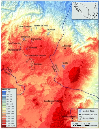
The Zaragoza-Oyameles obsidian source area in the Cuenca Oriental of Puebla, Mexico, was initially sampled by Cobean in the 1980s (Figure 1). Prior to that time, the location of the Zaragoza-Oyameles source was unknown and thus classified as Group C/C1 in XRF characterization studies (Cobean et al. Reference Cobean, Vogt, Glascock and Stocker1991:73). The first sites to be identified with obsidian from the source area were Olmec and date to the Early Formative period (Cobean et al. Reference Cobean, Coe, Perry, Turekian and Kharkar1971). A total of 53 geologic samples were collected by Cobean over eight or nine days from four loci in the source area (Glascock and Cobean Reference Glascock, Cobean and Cobean2002:242–243). These four loci include the “Zaragoza” and “Oyameles” sections of the source area. In the “Zaragoza” section, the collection locus was identified as the “Barranca canto—1 km al oeste del pueblo” (Glascock and Cobean Reference Glascock, Cobean and Cobean2002:242), which refers to the point where the old federal highway crosses the Acuaco River in the town of Acuaco, approximately 2 km west of the entrance to the town of Zaragoza (Cobean Reference Cobean2002:169). The Acuaco River originates 10 km to the southeast along the north side of the town of Oyameles, where the principal Oyameles obsidian exposures and workshops are located (representing one of Cobean's “Oyameles” collection loci). By the time the Acuaco River passes the town of Zaragoza and the area of Cobean's collection locus, it has received obsidian cobbles not only from the principal Oyameles obsidian exposures, but also from four additional exposures between the towns of Oyameles and Zaragoza. Chemically, the obsidian from all of those exposures is identical, suggesting that all the obsidian that contributed to Cobean's “Barranca canto—1 km al oeste del pueblo” samples is the same. Thus, all the geologic samples of Zaragoza-Oyameles obsidian used by MURR in comparative characterization studies come from Cobean's original collections, which come from one related flow-band system. Since those initial collections, several other programs of chemical characterization have been undertaken at the source area. García Cook and colleagues (Reference García Cook, Tenoria, Jiménez-Reyes, Monroy-Guzmán and López-Reyes2010) analyzed 17 samples collected from various exposures and sites across the source area using abbreviated INAA. Beyond this, the Zaragoza-Oyameles source samples characterized by Carballo (Reference Carballo2011:167; Carballo et al. Reference Carballo, Carballo and Neff2007), Jiménez-Reyes and colleagues (Reference Jiménez-Reyes, Tenorio, Esparza-Lopez, Cruz-Jiménez, Mandujano and Elizalde2001), and Millhauser and colleagues (Reference Millhauser, Fargher, Heredia Espinoza and Blanton2015), all came from spots within the source area encompassed by one of Cobean's “Oyameles” collection areas.
The Cuenca Oriental of Puebla, Mexico, showing selected modern towns, archaeological sites, and obsidian sources.

In 2012, the senior author initiated the Zaragoza-Oyameles Regional Obsidian Source Survey. Two of the project goals were to expand the reference base of source samples and to conduct an archaeological survey of the source area. We present data on the chemical characterization by INAA of 40 source samples and by XRF of 85 artifacts from the Zaragoza-Oyameles source area, in which three Zaragoza-Oyameles sub-sources were identified. The chemical signatures of these three distinct sub-sources are then compared to the INAA and XRF data in the MURR database from throughout western Mesoamerica in order to identify chronological and geographical patterns of source exploitation and examine what this implies about interregional exchange systems.
Geological Background
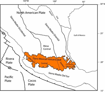
The obsidian quarried by prehispanic people at the Zaragoza-Oyameles source area is part of what is geologically termed the Zaragoza flow, also called the Cantonac flow by Ferriz and Mahood (Reference Ferriz and Mahood1984). The Zaragoza flow lies within the Los Humeros Volcanic center, located in the eastern part of the Trans-Mexican Volcanic Belt (TMVB), an east-west oriented geologic province that extends across central Mexico (Figure 2) and contains more than 20 active volcanoes. The evolution of the TMVB is divided into four main episodes of magmatism based on the chemical composition change of dominating volcanic activity (Gómez-Tuena et al. Reference Gómez-Tuena, Orozco-Esquivel and Ferrari2007:130).
The location of the project area within the Trans-Mexican Volcanic Belt (based on Gómez-Tuena et al. Reference Gómez-Tuena, Orozco-Esquivel and Ferrari2007:Figure 1).

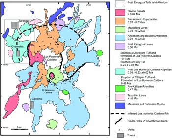
Activities in the Los Humeros volcanic field began more than 1.6 mya and continued to as recently as 0.02 mya (Ferriz and Mahood Reference Ferriz and Mahood1984; Figure 3). The field became active and entered the first stage at more than 1.6 mya, culminating with the eruption of the rhyolitic Xaltipan Tuff and the formation of the Los Humeros Caldera at 0.46 mya (Ferriz Reference Ferriz1985). Post-caldera rhyolitic activity occurred between 0.36 and 0.22 (±0.02) mya with (biotite) rhyolitic domes, including Cerro San Antonio on the edge of the later formed Potreros Caldera. The Potreros Caldera is an aphanitic rhyolitic flow and the source of the Zaragoza-Oyameles obsidian flow, which formed after the eruption of the Zaragoza Tuff at around 0.1 mya. This was followed by the eruption of two hypersthene rhyolite domes (Xonocuatla and the unnamed dome on the western side of Xonocuatla) on the northeastern rim of the Los Humeros Caldera.
Geologic map of the Zaragoza-Oyameles source area (based on Ferriz and Mahood Reference Ferriz and Mahood1984:Figure 2).

Archaeological Background
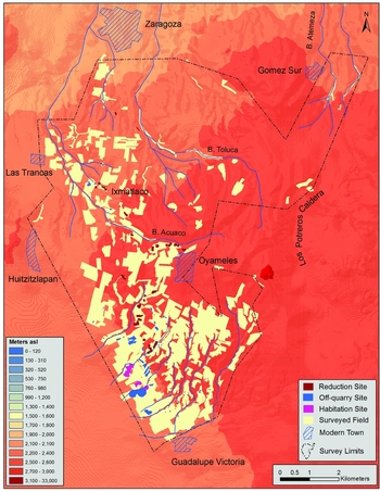
During the 2012–2014 field seasons, 1,543 hectares between the modern towns of Zaragoza in the north and Guadalupe Victoria in the south were intensively surface surveyed (Figure 4). The town of Oyameles de Hidalgo lies in the center of the survey zone. Zaragoza-Oyameles obsidian has been recovered from consumer site occupations dating to the Early or Middle Formative period contexts in the southern Gulf Lowlands (Cobean et al. Reference Cobean, Coe, Perry, Turekian and Kharkar1971; Hirth et al. Reference Hirth, Cyphers, Cobean, De Léon and Glascock2013; Pool et al. Reference Pool, Knight and Glascock2014; Santley et al. Reference Santley, Barrett, Glascock and Neff2001), the Lower Rio Verde Valley of Oaxaca (Joyce et al. Reference Joyce, Elam, Glascock, Neff and Winter1995), the Pacific coast of Guerrero, Mexico (Ebert et al. Reference Ebert, Dennison, Hirth, McClure and Kennett2014), and the Teotihuacan Valley in central Mexico (Stoner et al. Reference Stoner, Nichols, Alex and Crider2015:22). The early distribution of Zaragoza-Oyameles obsidian parallels the earliest distribution of Altotonga obsidian, which was an important obsidian source in the Early and Middle Formative periods across western Mesoamerica, but especially in the southern Gulf Lowlands (Boksenbaum et al. Reference Boksenbaum, Tolstoy, Harbottle, Kimberlin and Neivens1987; Cobean et al. Reference Cobean, Coe, Perry, Turekian and Kharkar1971; Pires-Ferreira Reference Pires-Ferreira and Flannery1976). From the Late Formative period through to the end of the Terminal Classic period (400 B.C.–A.D. 1000) Zaragoza-Oyameles obsidian comprised 80–90 percent of chipped stone assemblages throughout the southern Gulf Lowlands (Esquivias Reference Esquivias2003; Knight and Glascock Reference Knight and Glascock2009; Santley et al Reference Santley, Barrett, Glascock and Neff2001; Stark et al. Reference Stark, Heller, Glascock, Elam and Neff1992), and became increasingly important elsewhere in western Mesoamerica (Drennan et al. Reference Drennan, Fitzgibbons, Dehn and Isaac1990:188–189; Elam Reference Elam1993; Joyce et al. Reference Joyce, Elam, Glascock, Neff and Winter1995; Pires-Ferreira Reference Pires-Ferreira1975; Zeitlin Reference Zeitlin1982). At that time its distribution also included distant sites in the Maya area such as Tikal (Moholy-Nagy et al. Reference Moholy-Nagy, Asaro and Stross1984), the northern Maya Lowlands (Braswell Reference Braswell, Smith and Berdan2003:140), and the Pacific Coast of Guatemala (Bove and Medrano Busto Reference Bove, Busto and Braswell2003:53).
Surface survey limits of the 2012–2014 Zaragoza-Oyameles Regional Obsidian Source Survey, with selected archaeological features identified.

The archaeological remains of the ancient city of Cantona occupy an area of 1,430 ha and are located 10 km southeast of the Zaragoza-Oyameles source area (García Cook Reference García Cook, Sanders, Mastasche and Cobean2003:315). More than 100 radiocarbon dates have been produced from excavated contexts within the civic-ceremonial core of the city (García Cook and Zamora Rivera Reference García Cook and Rivera2010:33), dating the original settlement of Cantona to the Middle Formative period (ca. 600 B.C.) when it was a small hamlet. By 300 B.C. the site occupation grew to a population of 10,000 in an area of 200 ha. By about A.D. 400, in the late Early Classic period, a population of about 50,000 people occupied an area of 670 ha, and the city reached its apogee of 90,000 inhabitants around A.D. 750, during the Late Classic period (García Cook Reference García Cook, Sanders, Mastasche and Cobean2003:339). The last phase of its occupation dates to the Terminal Classic period (ca. A.D. 900/950–1000/1050; García Cook Reference García Cook, Sanders, Mastasche and Cobean2003:337). Several authors (Braswell Reference Braswell, Smith and Berdan2003; García Cook Reference García Cook, Sanders, Mastasche and Cobean2003, Reference García Cook, Mirambell and Arratia2014) have suggested that Cantona controlled the quarrying activities in the Zaragoza-Oyameles source area, but the nature of such control is unclear. Braswell (Reference Braswell, Smith and Berdan2003:139) emphasizes the proximity of Cantona to the source area as evidence of control, while García Cook focuses on the 350 obsidian-reduction activity areas in a 19 ha zone adjacent to the civic-ceremonial core of the city (García Cook Reference García Cook and Serret2014:107; García Cook et al. Reference García Cook, Tenoria, Jiménez-Reyes, Monroy-Guzmán and López-Reyes2010:219), especially the “state” workshops, which produced polyhedral cores for export and prismatic blades for local ceremonial use (García Cook Reference García Cook, Sanders, Mastasche and Cobean2003:337; Reference García Cook, Mirambell and Arratia2014:107–110). Although there is no doubt that a special relationship existed between Cantona and the source area or that the ebb and flow of Zaragoza-Oyameles obsidian consumption across Mesoamerica parallels the rise and fall of Cantona, no model has been proposed that describes the role of Cantona in the control over material procurement and the initial stages of tool manufacture. One goal of the survey was to collect data to elucidate the nature of this relationship.
During survey, seven archaeologists walked parallel transects spaced 5 m apart in plowed fields. In this way, we identified 100 percent of all surface sites within the survey limits. Depending on the size of a site, either all or a sample of the artifacts visible on the surface were collected. In the latter case, a 10 percent sample was recovered from randomly selected 5 × 5 m surface units. In non-site areas, all formal surface tools, such as projectile points, cores, bifaces, and scrapers, as well as all ground stone and ceramics, were marked with a handheld Garmin 62s GPS and then collected. In forested regions and streambed slopes, we walked parallel transects 10 m apart following slope contours or compass points. The survey identified 48 primary reduction sites, 3 habitation sites, 50 off-quarry sites, 117 obsidian exposures, 77 surface extraction pits, and 1 extraction trench. To some degree, the survey covered areas previously and unsystematically surveyed by Aline Lara Galicia (Reference Lara Galicia2003, Reference Lara Galicia2004). During that reconnaissance survey she identified 38 sites associated with obsidian reduction (Lara Galicia Reference Lara Galicia2004:28), which she subdivided into primary, secondary, and tertiary reduction loci. Due to different methodologies, specific site locations of most sites identified by Lara Galicia (Reference Lara Galicia2004:31, Map 6) could not be confidently matched with sites identified during our survey.
The types of sites we identified were differentiated principally by their artifacts and proximity to surface extraction pits. Primary reduction sites represent intense surface scatters of primary reduction material adjacent to an obsidian extraction locus (pit, trench, or exposed band) and contain no ceramic or ground stone artifacts. Off-quarry sites are surface concentrations of obsidian containing primary and secondary reduction debitage, but also ground stone, and, occasionally, ceramic artifacts. The association of these sites with specific extraction loci is unclear due to distance. The three habitation sites are large, intensive surface concentrations of primary and secondary obsidian reduction debitage and ground stone with relatively high ceramic counts and potential architectural remains.
Surface extraction pits are similar to those described by Healan (Reference Healan1997:86–87) as “doughnut quarries,” or elsewhere as depresiones de extracción (Darras Reference Darras1999:80–84), pozos de extracción (Pastrana Reference Pastrana1998:55), or “funnel-shaped pits” (Cobean Reference Cobean2002:169). We use the term socavón, employed by Lara Galicia (Reference Lara Galicia2003, Reference Lara Galicia2004). J. Gregory Smith of Northwest College conducted a program of topographic mapping in 2013 and 2014. This focused on known surface extraction features, including socavones and the single, identified trench.
Obsidian Sampling
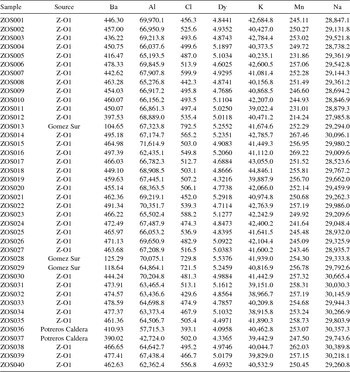
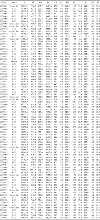
We collected samples from 46 of the 117 obsidian-band exposures that we identified. Most samples were collected from primary, 1–10 m thick flow-band exposures. Not all band exposures show signs of exploitation or are located near workshops. We submitted 40 source samples to MURR for INAA (Table 1). We also assayed 85 projectile points by XRF (Table 2). We analyzed these bifaces because some might be imports from other source areas. Almost all the projectile points were isolated finds, and we interpret most as hunting weapons lost in the pine and oak forest that typifies the Zaragoza-Oyameles source area.
Results of a Subset of Elements Analyzed by INAA of Geologic Samples from Zaragoza-Oyameles. Measured in Parts per Million.

Results of Element Analysis by pXRF of Surface Project Points from Zaragoza-Oyameles. Measured in Parts per Million.

Following García Cook's (Reference García Cook1967) typology, we recognized several types of projectile points. These include Hidalgo (Early Classic), Pedernales (Late Classic), Santa Clara (Early-Late Classic), Tecolote (Early-Late Classic), and Texcoco A (Late Classic-Postclassic) points. We also identified Shumla A and Shumla B points (stemmed-B and stemmed-A varieties, respectively, in Spence [Reference Spence1996]), which date to the Early and Late Classic periods. Shumla A and B style projectile points probably are not hunting weapons, and have been associated with the military elite of Teotihuacan (Carballo Reference Carballo2011:133–145, 159–163; Parry Reference Parry, Levine and Carballo2014:292; Spence Reference Spence1996; Sugiyama Reference Sugiyama1989). They are found throughout central Mexico (García Cook Reference García Cook1967:138, Plate 11, Tables 10, 29–33). Chemical characterization of these points was therefore important to determine whether they were made of local obsidian or were imports from Teotihuacan. The presence of Shumla A and B projectiles could reflect the need for military weapons at Cantona, interaction between Cantona and central Mexico, or the local manufacture of a central Mexican point style that spread beyond Teotihuacan. The Shumla A and B examples that we collected exhibit a pressure-flaking pattern different from that of Teotihuacan and may represent local production traditions, supporting the latter possibility (Knight Reference Knight, Englehardt and Carraso2017). Procedures and methodologies of INAA and XRF assays are presented as Supplemental Text 1.
Results of Chemical Characterization
INAA Analysis
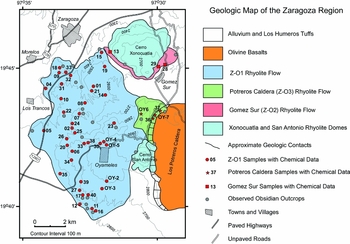
Three sub-sources of obsidian were identified from the 40 source samples: Zaragoza-Oyameles 1 (Z-O1), Gomez Sur (Z-O2), and Potreros Caldera (Z-O3; Table 1). The Z-O1 sub-source is the most common and widespread across the source area, representing 88 percent (n = 35) of our samples. Samples identified as Z-O1 were collected from a broad area across the survey zone (Figure 5). These include the large obsidian flow bands identified adjacent to the western and eastern side of the town of Zaragoza, and all the exposed flow bands between the towns of Zaragoza and Oyameles, including Cobean's “Oyameles” area. Z-O1 also includes all the exposures along the western side of the Oyameles Dome, west and southwest of the town of Oyameles. Samples collected from the Barranca Toluca, along the northern flanks of the Oyameles Dome, were sourced to Z-O1, as was low-quality but knappable obsidian recovered from a ravine just northwest of the town of Huitzitzlapan, 5 km west-northwest of Oyameles. Thus, the samples that characterize the Z-O1 sub-source were collected from an area that measures 11.6 km (north-south) by 4.5 km (east-west).
Collection locations of obsidian source samples in relation to local geology. OYA 6 and 7 represent samples analyzed by Hu and Nelson at Tulane, and thus are independent of the MURR sample.

The Potreros Caldera (Z-O3) sub-source is defined from just 5 percent (n = 2) of the submitted samples. The exposed flow bands that were the source of these samples cluster within the inside of the western wall of the Potreros Caldera, 4 km northeast of the Town of Oyameles. Evidence of macrocore and polyhedral core manufacture, such as percussion flakes and blades, was identified in the accumulated talus deposits downslope of several of these band exposures. The collection loci of the two samples are 1 km apart.
The Gomez Sur (Z-O2) sub-source is defined from 8 percent (n = 3) of the submitted samples. The exposed flow bands that were the source of these samples are located in the northern and northeastern edge of the survey zone. Two of the samples are from the town of Gomez Sur, and the third was recovered from a breccia deposit along the northern side of the Xonocuatla Dome, 4.5 km northwest of the other two samples (Figure 5). The Gomez Sur samples were collected from the walls of two ravines that drain the northern slopes of an unnamed rhyolitic dome along the northern edge of the Los Humeros caldera, approximately 8 km northeast of the town of Oyameles. Further north, these drainages enter a larger drainage system that passes through the towns of Tlatlauquitepec and Teteles de Ávila, 10 and 11 km downstream, respectively, both of which contain substantial prehispanic occupations. No signs of quarrying or other prehispanic activities were found near where we collected the Gomez Sur samples, but the fields adjacent to the ravines were not systematically or comprehensively surveyed.
XRF Analysis
Seventy-three of the 85 projectile points were made of Z-O1 obsidian, and the remaining 12 all are assigned to the Gomez Sur (Z-O2) sub-source (Table 2). No points were made from Potreros Caldera obsidian. All 15 examples of the Shumla A and Shumla B varieties of projectile point were made of Z-O1 sub-source material, and all were recovered from the western and southwestern slopes of the Oyameles Dome (the area closest to Cantona). This indicates that the points were made locally for use by people from that city. Elsewhere, Knight (Reference Knight, Englehardt and Carraso2017) suggests that Shumla A and B points may have been produced for special uses by the elite of Cantona, such as gift exchanges with people outside of the central highlands. The surface distribution of all other projectile-point types has no noticeable pattern, supporting the proposition that they were used for utilitarian tasks such as hunting.
Gomez Sur and Altotonga
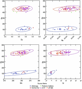
The Z-O1 and Potreros Caldera sub-sources have barium (Ba) concentrations in the 400 to 500 ppm range. In contrast, the three Gomez Sur samples have Ba concentrations of about 100 ppm. This is very similar to samples from the Altotonga source area, located 25 km to the east-northeast along the eastern edge of the Los Humeros Caldera in Veracruz. Cobean and his colleagues (Reference Cobean, Coe, Perry, Turekian and Kharkar1971:668) characterized Altotonga obsidian from cobbles found in a ravine 1 km north of the town of Altotonga. Ferriz (Reference Ferriz1985:367) mentions that Altotonga obsidian is not restricted to the area where Cobean originally found it, because it is part of the broader Xaltipan Ignimbrite formation. A combined plot of all of Cobean's Altotonga and Zaragoza-Oyameles (ZP-MX) source samples and the three sub-sources identified in this survey exhibit a close correspondence between Gomez Sur and Altotonga (Figure 6).
Element plots of Ba and Dy, Ba and Na, Ba and Mn, and Ba and Sr from INAA analysis of Zaragoza-Oyameles sub-sources and all Zaragoza-Oyameles (ZP-MX) and Altotonga source samples in the MURR database. Source groups are surrounded by 95 percent confidence ellipses. All element quantities are parts per million.

To explain the appearance of outcrops of Altotonga type obsidian in the Zaragoza region, we hypothesize that both Gomez Sur and Altotonga types of obsidian were formed before the Xaltipan geological event. Gomez Sur outcrops and samples are all located on the inferred north rim of the Los Humeros Caldera, and Cobean's (Reference Cobean2002) 15 Altotonga samples were collected outside the town of Altotonga, which is also outside the rim of the Los Humeros Caldera. We think that Altotonga obsidian is closely related to the Xaltipan tuff because cobbles of obsidian were found within ignimbrite. When compared to the silica-rich rhyolitic portion of the Xaltipan tuff, both the Altotonga and Gomez Sur have less strontium, but are almost the same in other elemental concentrations. Therefore, it is possible that immediately before or at the same time as the eruption that produced the Xaltipan tuff, some chemically similar obsidian flows erupted across the volcanic field. Nonetheless, due to the explosive eruption of Xaltipan tuff, not many flows are preserved at the surface, but during the eruption, clasts of such obsidian could have been included in the pyroclastic flows as accidental fragments. This may account for the “outcrops of small black obsidian cobbles” identified by Cobean (Reference Cobean2002:175) near the town of Tezuitlán, Puebla. A detailed geological survey from Zaragoza to Altotonga across the whole Los Humeros volcanic field and more radiometric dating data would be beneficial to understanding the occurrence of Altotonga source obsidian.
Comparison with Regional Data Sets Analyzed by Missouri University Research Reactor (MURR)
We compared the chemical signatures of the three Zaragoza-Oyameles sub-sources with artifact data from consumer sites in the entire MURR database in order to identify chronological and geographic patterns. This database, collected since 1988, contains 821 Zaragoza-Oyameles artifacts assayed by INAA and 288 analyzed by XRF. Such artifacts are coded at MURR as “ZP-MX.” The artifacts come from sites across most of Mesoamerica dating to many periods. Supplemental Table 1 summarizes the artifact data used in this comparison for INAA, and Supplemental Table 2 summarizes the data used in XRF.
INAA
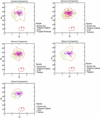
For Zaragoza-Oyameles obsidian, the greatest intra-source variation in elemental composition is exhibited by Ba and cobalt (Co). Unfortunately, Co and other useful elements are assayed through the long irradiation procedure, which was not used to identify most artifacts. Thus, we employed Ba and dysprosium (Dy), both of which are assayed through the abbreviated-INAA process. Figure 7 displays artifact data for consumer sites as compared with the 95 percent confidence kernel ellipses for the three sub-sources.
Element plots of Ba and Dy from INAA analysis of Zaragoza-Oyameles sub-sources and all Zaragoza-Oyameles consumer site samples in the MURR database, by geographical region. Source groups are surrounded by 95 percent confidence kernel ellipses. All element quantities are parts per million.

The vast majority of the consumer artifacts sourced to Zaragoza-Oyameles in the MURR database come from the Z-O1 sub-source. Just one of the analyzed consumer site samples matches the Gomez Sur sub-source, and 4 percent (n = 33) is assigned to the Potreros Caldera sub-source. These artifacts attributable to the Potreros Caldera sub-source come from a number of regions, including Oaxaca, Tabasco, Yucatán, Puebla, Mexico State, Tamaulipas, and Veracruz (Supplemental Table 3). Unfortunately, we lack typological data for these artifacts.
XRF
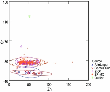
For artifacts analyzed by XRF, we used strontium (Sr) and zinc (Zn) concentrations to distinguish among the three sub-sources. Once again, the vast majority of the Zaragoza-Oyameles artifacts in the MURR database come from the Z-O1 sub-source (Figure 8). Only one consumer artifact (DTW039), from coastal Oaxaca, is assigned to the Altotonga/Gomez Sur chemical group. An outlier exists, which is a projectile point from the Zaragoza-Oyameles source area that contained unusually large quantities of Sr.
Element plot of Sr and Zn from pXRF analysis of Zaragoza-Oyameles sub-sources, and all Zaragoza-Oyameles (ZP-MX) and Altotonga consumer site samples in the MURR database. Source groups are surrounded by 95 percent confidence ellipses. All element quantities are parts per million.

Discussion
Unsurprisingly, the geologic samples of the Z-O1 sub-source come from flow bands near the towns of Zaragoza and Oyameles. The largest and most intensive quarrying zones are located immediately north of Oyameles, along the southern face of the Barranca Acuaco, and along the western edge of the Oyameles Dome. We also identified considerable quarry activities north of the Barranca Acuaco, in Ixmatlaco and adjacent to Zaragoza. One of the largest socavones identified in the survey is next to the toll road entrance to the town of Zaragoza. Much of this reduction workshop was destroyed by construction of the road, but what remains indicates that it was a major locus of quarrying and initial reduction activities.
What do these results imply for the distribution of obsidian across Mesoamerica? Survey and excavation at the city of Cantona have identified extensive obsidian workshops, suggesting intensive production of prismatic blades for local consumption and of blade cores for export (García Cook Reference García Cook, Sanders, Mastasche and Cobean2003:337; García Cook et al. Reference García Cook, Tenoria, Jiménez-Reyes, Monroy-Guzmán and López-Reyes2010). The rise and fall of the city corresponds to the principal pulses of Zaragoza-Oyameles obsidian distribution throughout Mesoamerica. It is clear that Cantona had a special relationship with the source area, and that this was focused on the Z-O1 sub-source. Our identification of three large habitation sites implies that extraction of Z-O1 obsidian was conducted by families living adjacent to some of the quarries (Knight Reference Knight2015). We recovered a relatively large number of ceramic sherds (n = ~520) from these habitation sites, but they await analysis. Lara Galicia's (Reference Lara Galicia2003, Reference Lara Galicia2004) earlier reconnaissance and ceramic analysis indicate that pottery from the area near these quarries is similar to that consumed at the city of Cantona during the Early and Late Classic periods, which suggests that the Zaragoza-Oyameles habitation sites were consuming ceramics associated with Cantona. Next to no ceramics were recovered from the quarry and reduction sites closer to the town of Zaragoza or from the surfaces adjacent to the Potreros Caldera or Gomez Sur flow bands. Therefore, the nature of the relationship of these sub-source areas to Cantona is not understood.
The 33 Potreros Caldera Artifacts from Consumer Sites
Although incomplete, temporal data for the Potreros Caldera artifacts in the MURR database indicate that obsidian from that sub-source was consumed across several time periods. In the southern Gulf Lowlands, where most obsidian from this sub-source was used, the four Palo Errado samples come from layers that date to the Protoclassic and Early Classic periods (Knight Reference Knight1999:294–297). The single sample from La Mixtequilla dates to the Classic period (Heller Reference Heller and Stark2001:167, Table 9.7), but the artifact from El Macayal, Veracruz, likely dates to the Early Formative period (Travis Doering, personal communication 2015). Unfortunately, temporal data for the 12 samples from the Tuxtla Mountains are not available. Further afield, the six samples from Yucatán all likely date to the Early Postclassic (Geoffrey Braswell, personal communication 2015). The wide temporal breadth of Potreros Caldera obsidian consumption—from before, during, and possibly after the Cantona occupation—indicates that Cantona was not solely responsible for this material entering long-distance exchange networks. The same can be said for the more common Z-O1 sub-source, with which Potreros Caldera obsidian was traded.
The Potreros Caldera sub-source is located 4 km northeast of the town of Oyameles and the principal Z-O1 quarries. Quarrying activities at the Potreros Caldera source area are minimal. Instead, it appears that exposed obsidian bands emanating from the steep slope of the inner caldera wall were opportunistically exploited. If obsidian from Potreros Caldera entered Mesoamerican exchange networks via Cantona, then its inclusion was more the product of ad hoc collection than systematic, controlled quarrying. This is very different from the extraction of Z-O1 sub-source material along the western and northwestern edges of the Oyameles Dome. Therefore, several systems of obsidian collection, possibly by several groups of people or communities with territorial claims to local flow bands, could have contributed to the obsidian entering Cantona.
Another possibility is that Potreros Caldera obsidian may have entered Mesoamerican exchange networks independently of Cantona. The Potreros Caldera and Gomez Sur sub-sources are separated by a large, flat plain, and the Potreros Caldera area would have been more accessible to people to the north than to people in the Oyameles area. Prehispanic sites have been identified to the north of the Gomez Sur sub-source area at Tlatlauquitepec and Teteles de Ávila. On a brief site visit to Teteles de Ávila in the spring of 2015, we observed at least 15 large (10–12 m high) mounds in the site core, thus this site could represent a regional center. We know of no published investigations of the site, and its occupation span and general layout are unknown.
Altotonga/Gomez Sur Distribution
The similarity of Gomez Sur sub-source obsidian to material from Altotonga may indicate that some obsidian from Gomez Sur also entered ancient Mesoamerican long-distance exchange networks. The physical location of the Gomez Sur sub-source exposures, as well as known Altotonga outcrops, suggests collection by groups along the slopes of the northern side of the Los Humeros Caldera. These might have been based at Tlatlauquitepec and Teteles de Ávila, or at other centers closer to the modern town of Altotonga. Like Z-O1 and Potreros Caldera obsidian, Altotonga material was traded before the settlement and development of Cantona. Nevertheless, during the Classic period, Altotonga/Gomez Sur obsidian was traded through the same network as Z-O1 material. For instance, at Laguna de los Cerros in the Sierra de los Tuxtlas of Veracruz, the Altotonga/Gomez Sur material comprises 9 percent (n = 23) of the Early Classic, 19 percent (n = 34) of the Late Classic, and 12 percent (n = 15) of the Terminal Classic period sample (Ramírez Sánchez Reference Ramírez Sánchez2008:127, Table 12). In the Isthmus of Tehuantepec, Zeitlin (Reference Zeitlin1982:268) found that Altotonga comprises 17 percent of the Early Classic sample and 48 percent of the Late Classic sample. A recent study by Barca and her colleagues (Reference Barca, Miriello, Pecci, Barba, Ortíz, Manzanilla, Blancas and Crisci2013) finds that the rhyolitic glass shards used as aggregate in the stucco floors of the central courtyard of Teopancazco, an Early Classic, multiethnic neighborhood of Teotihuacan, came from the Altotonga magmatic system. Linda Manzanilla (Reference Manzanilla2011:22–25) suggests that trading caravans were organized between Teopancazco and the central Gulf Lowlands at Nautla, Veracruz, to secure Gulf Coast commodities. Cantona is located right in the middle of one of the least-effort routes to the coast from Teotihuacan, yet artifacts from Cantona and the architecture of the city exhibit little connection with Teotihuacan (García Cook and Merino Carrión Reference García Cook and Carrión1998:197; Gómez Santiago 2010). In fact, Cantona would have directly competed with Teotihuacan for access to commodities from the Gulf Lowlands during the Early Classic period (García Cook and Vackimes Serret Reference García Cook and Serret2014:239–240). It is possible, then, that the Teopancazco trade route veered farther north along the northern slopes of the Los Humeros Caldera to reach Nautla, and thus received northern slope materials such as Altotonga rhyolitic glass from the populations living there. As a result, obsidian from the Potreros Caldera area may have entered regional exchange networks in a manner similar to Altotonga/Gomez Sur materials during the Formative and Classic periods.
Conclusions
A program of intensive surface survey, source sampling, and chemical analysis has resulted in a substantial increase in our understanding of how obsidian was exploited in the Zaragoza-Oyameles source area. The role of Cantona in the extraction and production of macrocores and polyhedral cores is still under investigation, but the data point to a focus on the Z-O1 sub-source by the Cantona elite. The discovery of two other sub-sources in the Zaragoza-Oyameles source area, and the early Mesoamerica-wide distribution of obsidian from them, indicate that locals engaged in extraction and production activities before the founding of Cantona. Thus, it seems likely that the early Cantona elite co-opted and expanded preexisting systems of obsidian extraction, production, and distribution, particularly in regard to some of the Z-O1 obsidian flow bands. These preexisting systems may have continued during the occupation of Cantona in the form of opportunistic extraction of Z-O1 obsidian flow bands, and the same thing may have occurred at Potreros Caldera and Gomez Sur. New chemical data showing that Gomez Sur obsidian is chemically indistinguishable from material from Altotonga, a better-known source to the east, makes this more likely. The chemical similarity of Gomez Sur and Altotonga obsidian widens the geographical distribution of potential exploitation loci of this obsidian across the entire northern slopes of the Los Humeros Caldera. This, coupled with the identification of the Potreros Caldera sub-source and its broad temporal use at consumer sites in the southern Gulf Lowlands, introduces the possibility that alternative avenues existed for Zaragoza-Oyameles source area obsidian to enter Mesoamerican exchange networks without being channeled through Cantona.
The increased detail on intra-source variation at the Zaragoza-Oyameles source area was achieved through intensive surface survey and the collection of geologic samples. Portable XRF is becoming an increasingly popular and cost-effective method of artifact characterization, especially in the field. As a result, we have begun to see much larger consumer site samples characterized than ever before (e.g., Ebert et al. Reference Ebert, Dennison, Hirth, McClure and Kennett2014; Hirth et al. Reference Hirth, Cyphers, Cobean, De Léon and Glascock2013; Milić Reference Milić2014; Moholy-Nagy et al. Reference Moholy-Nagy, Meierhoff, Golitko and Kestle2013). Yet, no matter how many artifacts from consumer sites are chemically characterized, the conclusions generated from those studies are still constrained by the nature and quality of source data. Unlike individual sites, obsidian source areas are difficult to survey and interpret, and can produce a volume of archaeological material beyond the time and financial limits of most projects. Nonetheless, with carefully developed survey methods and sampling strategies that include a multidisciplinary approach, significant new information can be generated. The increased resolution of data afforded by such methods allows for more nuanced interpretations of the political and economic systems behind obsidian artifact distribution and consumption. These techniques can be applied throughout Mesoamerica and beyond.
Acknowledgments
The Zaragoza-Oyameles Regional Obsidian Survey was supported by National Science Foundation grant BCS-1063233. Permission to conduct this research was granted by the Instituto Nacional de Antropología e Historia in 2012 (Permit Number, Ofic., Núm. 401-.C(4)19.2012/013), in 2013 (Permit Number, Ofic., Núm. 401.B(4)19.2012/36/2213), and in 2014 (Permit Number, Ofic., Núm. 401.B(4)19.2013/36/2094). We give our sincerest gratitude to Dr. Ángel García Cook for his unflagging support throughout every stage of this project. We thank the staff of the Museo de sitio de Cantona and their Director Arqlgo. David R. Cuevas Pastrana for their enthusiastic assistance and use of curation space. We thank all the crew members who participated over the three seasons, as well as the communities of El Retiro, Ixmatlaco, Las Trancas, Oyameles, Tlatlauquitepec, and Zaragoza. We also thank Dr. Ana Maria Boada for kindly translating the abstract into Spanish, and four anonymous reviewers for their insightful and helpful comments on an earlier draft of this paper. Finally, we thank Dr. Robert Cobean for his encouragement to develop the project in the first place; he helped out in more ways than we can list here.
Data Availability Statement
Obsidian characterization data presented here are archived at MURR. All other materials collected during the Zaragoza-Oyameles Regional Obsidian Source Survey are permanently curated at the Museo de sitio de Cantona, an INAH facility at Cantona, Puebla, Mexico. Inquiries into digital data formats can be made to the project director, Dr. Charles L. F. Knight (cknight@uvm.edu).
Supplemental Materials
Online supplemental materials are linked to the online version of this paper, which is accessible via the SAA member login at https://doi.org/10.1017/laq.2016.2. These include the following files:
Supplemental Text 1. Procedures and methodologies of INAA and XRF assays.
Supplemental Table 1. Zaragoza-Oyameles samples characterized by INAA in the MURR database from consumer sites showing site name, location, quantity, and related publications.
Supplemental Table 2. Zaragoza-Oyameles samples characterized by XRF in the MURR database from consumer sites showing site name, location, and quantity.
Supplemental Table 3. Samples in MURR INAA database that correspond to the Gomez Sur and Potreros Caldera sub-sources.