

The recent reawakening of interest amongst archaeologists and historians in the Bokoni settlements, located on the Mpumalanga escarpment, which form the largest known terraced site on the continent, provides an opportunity to rethink some of the processes of economic change that emerged in precolonial Southern Africa.Footnote 1 These communities have left by far the most prominent footprint on the landscape of any precolonial society in the region. They represent a level of economic development accompanied by complex institutional innovations that raise new questions about precolonial Africa.
After outlining the evidence on how these farming communities organised their production and how they related to an evolving regional context, we seek to shed new light on these processes. In order to understand the local and regional institutional arrangements that permitted the rise and persistence of intensive farming on a considerable scale, we draw on a range of perspectives and evidence, primarily from the historical literature on precolonial Southern Africa. We argue that the crucial determinants of economic change on the terraces were competing pressures for stability and for openness (or a relative absence of social and political restrictions), which, in the context of changing environmental and global circumstances, interacted in complex ways to push the process of economic development along oscillating, unpredictable paths.
We then show how these forces could have shaped the rise, the persistence, and the sudden disappearance of the Bokoni terraces. It is unlikely that the Bokoni case reflects a pattern that was wholly reproduced in other parts of Africa, and we believe that our research has most direct implications for understanding economic change in precolonial Southern Africa.Footnote 2 We do, however, raise questions about some views on the precolonial roots of African poverty, especially those of Daron Acemoglu and James Robinson who have made a strong case for the absence of centralised states as a main cause of Africa's long-term poverty.Footnote 3 One of the problems of Acemoglu and Robinson's approach is that they do not adequately take into account complex and innovative arrangements that emerged in different African contexts. As we set out to show in this article, such arrangements could generate significant growth in ways that do not fit neatly into models of development derived largely from European examples.
Bokoni sites have been studied intermittently since the 1930s. Important work was done in the 1970s in establishing key features of these settlements. But for the last thirty years the dominant interest in them has been on their place in an evolving ethnic jigsaw puzzle.Footnote 4 Until recently, they have not been seen as especially significant economically. But work by Tim Maggs helped to ensure that they were located in the context of other intensive agriculture sites in East and Central Africa, and underscored their wide distribution. Current research suggests that the full extent of these sites is probably still underestimated.Footnote 5
At present, the evidence on Bokoni, which is primarily archaeological but supplemented by significant collections of oral traditions, does not allow us to draw definite conclusions. Nevertheless, we believe that it is already sufficiently suggestive to help us think through issues relating to the region's economic performance, and how its structural character may fit into broader patterns of economic development. Interest in this topic is increasing and, given the improved economic performance of many African countries over the past ten years, new research is producing a more varied and complicated picture than was previously the case.Footnote 6
THE POLITICAL ECONOMY OF BOKONI
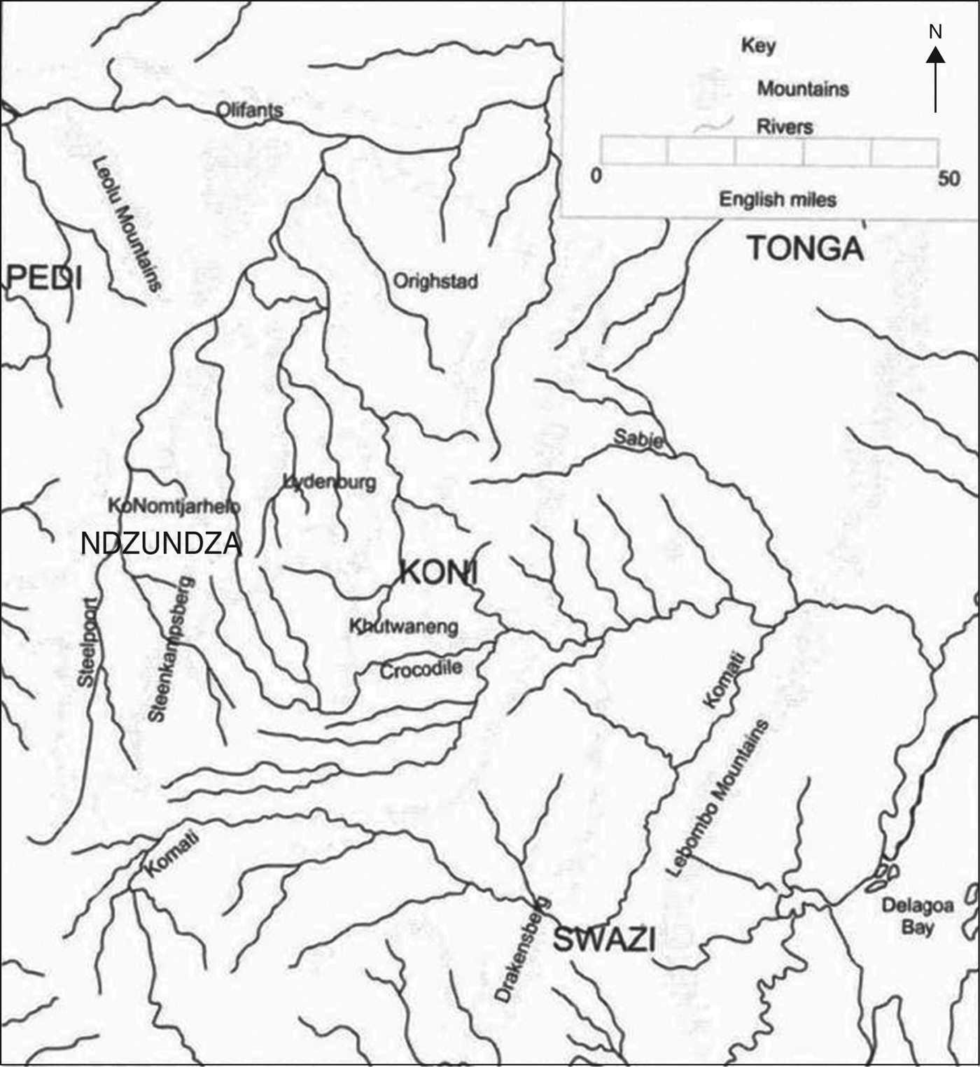
The Bokoni hillside settlements spanned an area of 150 kilometres north to south, and 50 kilometres or more east to west, situated between the modern South African towns of Ohrigstad in the north and Carolina in the south. They consisted of densely-walled settlements with roughly circular homesteads linked by walled cattle paths situated among spreads of agricultural terraces. Particularly dense complexes sometimes extended over several square kilometres, but these larger villages were interspersed with a range of smaller settlements. Even relatively isolated homesteads were sometimes situated within terracing that traversed mountain slopes for long distances. Terraces closest to homesteads were often the most elaborately built and subdivided. The existence of cross-cutting walls radiating out from the household divisions suggests that the gardens adjoining homesteads fell under the control of particular families.
The distribution of settlements in Bokoni, South Africa.

Bokoni and neighbouring area.
The homesteads were built close to perennial rivers, but the groups in Bokoni in the main eschewed concentrated settlement in the valley bottoms and cultivated along valley slopes.Footnote 7 Bokoni enjoyed higher rainfall (660–10000 mm per annum) than the bushveld areas that lay to the north and east, which supported major neighbours and rivals including the Pedi kingdom. The layout of the cattle paths suggests that the upper and lower reaches of the valley sides were used for seasonal grazing, and the existence of cattle posts suggests elements of more wide-ranging pastoral strategies which have yet to be fully reconstructed. These settlements went through a number of phases of development and distribution from at least the 1500s.Footnote 8 In the early nineteenth century, an upsurge of attacks by groups propelled in to the interior by the upheaval of the Mfecane resulted in heavy losses of grain, livestock, and people; by the 1830s, the homesteads were almost entirely abandoned and the terraces slowly fell into disrepair.Footnote 9
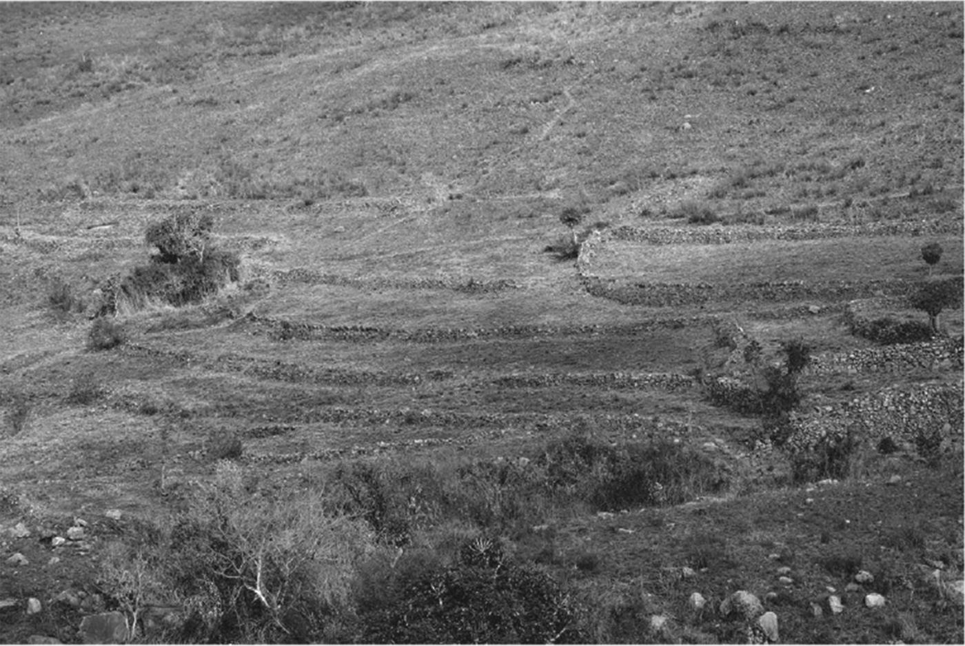
Today, visitors to the area are struck by the pervasiveness of these stone structures and the beauty of the landscape in which they are located. Those that fly over the escarpment marvel at the patterns that the walls and terraces create in the grasslands below (see figures 3 and 4). Some cannot accept that they are of African origin, which has given rise to literature that stresses other ancient influences, such as Indians.Footnote 10 Sadly, it is unlikely that we will ever be able to fully reconstruct the ways in which those who lived within these walls viewed their world. But the existence of thousands of rock engravings (see figure 6), which appear to represent these settlements, opens one window on their perceptions.
An excavated homestead and cattle path.
Homesteads, terraces, and connecting cattle paths.
A cleared section of terraces at Verlorenkloof.
One of many engraved stones at Boomplaats near Lydenburg.
At present, while our understanding of the innovation, investment, and coordination employed at Bokoni is far from complete, a broad sense of key aspects is emerging. It is likely that cattle manure, which was collected from central cattle enclosures, was used on the terraces. The fact that cattle were moved between the enclosures and fields along carefully constructed stone-lined paths allowed considerable concentrations of cattle to be held at the heart of settlements throughout the year without danger of damage to crops. Irrigation appears not to have been as extensive and well-developed as in some other African areas of intensive cultivation, but the relatively high rainfall and the settlements' proximity to seasonal streams that tended to flood and run down the escarpment through the fields probably made elaborate canal systems unnecessary. It is also likely that the system of terraces was effective in both retaining and distributing moisture.Footnote 11
Trade and regional integration were additional features facilitating the intensive farming at Bokoni. Maggs has pointed out that these societies would have been particularly significant consumers of iron goods, but iron production is unlikely to have taken place on sufficient scale in the area to meet this demand. There is also no evidence that copper, which was also a vital element in regional trade, was produced in Bokoni. We therefore have to consider Bokoni as part of a wider system of iron and copper production and trade, which included the exchange of grain for metals.Footnote 12 There is good evidence that these societies were linked into still longer distance trading networks. However, given their location and forms of organisation, they are unlikely to have been major producers of ivory, which was the key commodity traders demanded in the long distance trading networks of the region after 1500 CE. What then was their role? Intensive agricultural production may have allowed them to specialise to some extent and to generate food products in return for other necessaries and luxuries. It is also possible that Bokoni's intensive forms of food production provided elements of food security to their more vulnerable and/or alternatively specialised neighbours.Footnote 13 In some ways, they may have represented the opposite end of a continuum which also included the iron-working communities in the infertile parts of the lowveld, who specialised in metal working and exchanged their products for cattle and grain as well as trade goods brought from the coast.Footnote 14 But security of subsistence was not an effective shield against all forms of risk. As we explore further below, lush fields and large herds of cattle may also have provided an incentive for more expansionary and aggressive states to raid and invade.
These settlements have increasingly been viewed within the comparative context of the islands of intensive agriculture elsewhere in Southern and Eastern Africa, which represent a significant deviation from more common extensive, low-investment farming practices often assumed to be pervasive in sub-Saharan Africa. It is likely that agriculture in these, often irrigated and terraced, intensive farming settlements required a much higher level of investment, commitment, coordination, and innovation than the farming practised in other parts of Africa. Mats Widgren provides a helpful summary:
The high productivity of land and the robust application of agricultural production in these areas depended on the application of different combinations of farming practices: manuring, composting, terracing, cut-off drains, a variety of irrigation techniques and a diverse crop repertoire. Furthermore in several instances there is evidence of careful management of trees and woodlands and a high level of agro-diversity. Irrigation and soil conservation are connected with investments in land which has been termed landesque capital defined as activities on the land (and vegetation) that reach beyond the immediate needs of the coming cropping season.Footnote 15
Comparative material from East Africa suggests many other questions. Amongst the most interesting of these is that some islands of intensive agriculture were closely connected to wider pastoral economies, and individuals would move between these forms of production in a way which clearly suggests that thinking of them as separate economic systems is likely to be misleading. This perspective further underscores the need for more systematic consideration of how to create dynamic frameworks that move beyond a localised, sometimes effectively tribal discussion of economies.Footnote 16
The existence of a system of relatively intensive agriculture along with the regional and long-distance trade networks also begs questions about the form of political organisation that existed in the area. The archaeological evidence from Bokoni is of a relatively dense population spread out over a large area. This contrasts sharply with the relatively concentrated populations of early nineteenth-century states such as the Zulu, Swazi, and Pedi, which reflect their centralised political power. In terms of built settlement patterns, Bokoni had loose aggregations of homesteads forming sprawling settlements, which are nothing like the compact, unitary, capital sites of, for example, the Zulu, Swazi, Pedi, and Tswana kingdoms. While Bokoni homesteads vary in size and complexity, there is little evidence of hierarchy. This pattern implies not so much the centralisation of political power, as an emphasis on the maximum use of potential agricultural land. At neither the homestead nor the settlement level are there obviously dominating buildings or sets of buildings. The archaeological surveys have also not found material culture at any of the sites that expresses sharp social distinction.Footnote 17
The material and oral evidence suggests that there were a number of overlapping and even competing centres of political power in Bokoni. A possible model here may be a cluster of chiefdoms with some form of rather weak paramountcy. The Pedi kingdom brought some areas into a tributary relationship from the 1750s.Footnote 18 But the political order in Bokoni remained highly devolved in much of its operation, containing important elements of both regional power and local autonomy. For much of the period 1600–1820, we seem to be dealing with a range of forms of political and ritual paramountcy which probably involved the expansion of control by dominant lineages over diverse populations. It is, however, by no means clear that one discrete political system incorporated all the groups who may be described as Koni. This impression is reinforced by the ways in which Koni factions became involved in Pedi succession struggles.Footnote 19
The evidence from Bokoni suggests that a range of political and economic innovations emerged on the terraces, which generated agricultural outputs that were higher and less unpredictable than was the norm. It is also clear that these developments were part of, and therefore cannot be understood in isolation from, a complex regional order. It is important therefore to place the terraces within the broader context of the socioeconomic environment of precolonial Southern Africa.
STABILITY AND DYNAMISM IN PRECOLONIAL SOUTHERN AFRICA
The work on precolonial Southern Africa has been usefully summarised in the Cambridge History of South Africa.Footnote 20 Simon Hall's chapters, in particular, provide a helpful starting point for an understanding of the broader dynamic context in which the Bokoni terraces were situated. He points to elements of both change and continuity in the historical record. As he puts it: ‘The ability to move, resettle, shift allegiance, and create new identities in the pursuit of political and economic advantage is an enduring theme within African political culture.’ However, within this context of dynamic change, there are also ‘considerable continuities in African cultural principles and these are contextually used again and again in redefining identities and creating new political structures’.Footnote 21
This is a useful starting point for analysing the economic history of precolonial Southern Africa.Footnote 22 A major source of economic stability in the precolonial context must have been the quest to establish economic security in a hostile, unstable environment.Footnote 23 Entrenched economic practices emerged that emphasised security over innovation as a way to avoid unpredictable disasters and famines.Footnote 24 There is in fact nothing particularly African about this. Concern with avoiding risks and ‘extinction by crop failure’ has been a common concern of farmers throughout the world.Footnote 25
However, in precolonial Southern Africa – where societies depended heavily on agriculture and confronted unstable markets, poor soils, and a very variable climate – the concern with security may have been particularly strong. Risk minimising features of African social systems included fields spread over vast distances to ensure that a mix of land with different types of soils and in different rainfall regions were used. This increased the costs of agricultural production but reduced the risks of crop failure and famine. Chiefs also regulated work patterns in ways that helped prevent desperate individuals from pursuing short-term interests.Footnote 26
If the quest for security was one source that promoted stability and undermined innovation, then the forms taken by African cultures, which partly reflected the focus on communal food security, may have been another. In the analysis of Africa's economic development, culture is frequently portrayed as a set of values into which individuals are socialised and which they are unable to question or change. But a more dynamic perspective on culture is possible and has been developed by John Lonsdale, who in the Kenyan context identified private accumulation as a central component of the Kikuyu moral order. At the same time, there was a strong moral and political tradition amongst the Kikuyu in which private ambition had to serve the collective good. These communal obligations must have dampened individual initiative but, Lonsdale claims, the tension between the two ensured that there were ongoing debates within societies about how much of a family's resources needed to be made available to how many.Footnote 27 Cooperative values were an element within debates that were also fuelled by economic interests.
There is ample evidence for similar patterns in Southern African societies. It was, for example, expected that chiefs would accumulate significant amounts of wealth that in some instances were many multiples of that enjoyed by the majority of their subjects. But this norm was counterbalanced by the expectation that political leaders would be generous with their wealth and provide support for the poor and the hungry. The exact balance of these expectations was the subject of ongoing debate, and the extent of the power and legitimacy of particular leaders shaped the point at which the pendulum came to rest. For example, in the Pedi kingdom during the mid-nineteenth century:
An example of the way in which rulers fostered the image of themselves as benefactors rather than extractors … [was that] while all gifts presented to chiefs in private and in secret, chiefly beneficence was always given the maximum possible public display.Footnote 28
This pattern was not restricted to office holders. More generally, accumulation was accepted if the wealthy were seen as generous and loyal from both above and below. Failure to achieve this balance could lead to serious sanctions – not least of which was being accused of witchcraft – but this did not prevent individuals from amassing considerable wealth, especially in cattle and trade goods. As a result, deep economic disparities existed even within the ranks of commoners.Footnote 29 More broadly, early travellers reported on numerous trials in which individuals were accused of hoarding and selfish behaviour. The fact that these trials were a regular feature of African societies demonstrates that some element of ‘selfish’ accumulation was practiced by many Africans in the region.Footnote 30
Evidence of widespread trade is important both as a sign that accumulation and dynamism were deeply entrenched in Southern African systems and as an important external source of economic change. The existence of trade from very early times demonstrates that individuals were prepared to innovate, often in an incremental way, to make use of new economic opportunities. During the first millennium, trade interactions between pastoralists, hunter gatherers, and sedentary agriculturalists were crucial in promoting the use of cattle (and possibly stone enclosures) by agriculturalists and the use of iron implements by herders and hunter-gatherers.Footnote 31
From as early as the fourth century, areas of Southern Africa rich in salt, iron, or copper produced economic specialisation. The standard of living achieved by the miners and manufacturers who settled in these areas could not have been based on agriculture in these relatively barren regions; it was clearly derived from exchanging their iron or salt products for the crops and cattle produced in other parts of Southern Africa.Footnote 32 The existence of these areas of specialisation demonstrates the extent to which people could adapt their social structures and economic practices in response to both environmental variation and economic opportunities.
Precolonial societies in the region were also shaped by the social tension between chiefs and commoners.Footnote 33 Chiefly ideology was expressed as a form of domination. It sought to entrench and to accentuate the distinction between chief and commoner. Numerous rituals were enacted to underline the superiority of the chief, and commoners were expected to accept this superiority obediently. Chiefs used their social power to extract wealth, primarily cattle, labour, and trade goods from their subjects.Footnote 34 Why did commoners accept chiefly authority? Religious beliefs and practices accorded chiefs powers to mediate with supernatural forces on behalf of their followers. People saw value in someone with authority to help define social order, to resolve disputes, to coordinate decision-making, and to enforce norms of social redistribution. Equally important was the ability of effective leaders with a strong following to provide for the safety of their subjects and their property. The importance of this requirement fluctuated with the degree of military threat in any period. Populations dispersed in times of relative peace and concentrated when the risk of attack was greater.Footnote 35 Relatively decentralised power of the kind that emerged in Bokoni was, therefore, probably associated with periods of stability and a relatively high degree of economic security.
Lastly, the intensification of international trade had the potential, but did not necessarily lead to, major social changes and the injection of a new economic dynamism. In some places the expansion of trade opportunities led to the disruption of the social order, while in others they produced a movement towards a defensive consolidation of the existing order.Footnote 36 Some chiefs saw increased trade as a threat to their position, while others sought to benefit from it. Nevertheless, along many of the new trade routes, relatively small groups of people established themselves as intermediaries. Many of these communities settled on hills to enhance their defences against other aggressors.Footnote 37
Amongst the Tswana chiefdoms, it is possible to detect a trend towards the establishment of large towns, with populations of between ten and twenty thousand. At the same time, jostling for position between Tswana chiefdoms, sometimes through violent confrontation, became commonplace.Footnote 38 Amongst the Pedi, the Maroteng chieftaincy was able to establish increasing control over trade and to promote centralisation under its leadership. Control over trade allowed rulers to ‘accumulate prestige goods, to attract and control subjects and clients, and to entrench their pivotal position in internal systems of exchange and redistribution’.Footnote 39 Further, the decline in trade was a factor in an increase in conflict during the period 1790–1820 as the Pedi paramount attempted to sustain his wealth and power by strengthening and extending his control over trade. His attempts to extend his control over Bokoni to the south may have been shaped by a concern to expand control over both trade and agricultural production.Footnote 40 Among the Mthethwa, Ndwandwe, and Zulu, attempts were made from 1817 to control the trade with Delagoa Bay. Rivalry between these chiefdoms and a drive towards centralisation eventually led to a large part of present day KwaZulu-Natal falling under the control of the Zulu.Footnote 41
Trade with the outside world was often accompanied by exposure to new ideas and methods practiced by the Arabs, Portuguese, and other middlemen. African societies in the region were open to adopting new techniques in the context of the trade. They adopted Indian cotton spinning techniques in Mapungubwe, for example, and, where the opportunity presented itself, they undertook extensive mining for gold. Later they readily adopted maize as a new staple crop. However, in a recent overview, David Killick emphasises the limited interchange of technical knowledge between southeastern Africa and the Islamic world:
There is essentially no evidence for the introduction of Islamic techniques for mine drainage, nor for the exploitation of copper sulphide ores. African copper mining was restricted to the superficial oxidized zone of copper ore bodies above the water table. Both gold and tin were clearly mined by African miners, not by Indian or Arabian immigrants (both of whom have been proposed as candidates), but the mining of these metals was just as clearly in response to external demand from the lands around the Indian Ocean.Footnote 42
Killick partly ascribes this timid technological emulation to the unequal exchange between more advanced and less advanced regions of the world, which may have some validity. But rather than regarding African societies merely as victims of asymmetrical exchanges, our argument is that one also needs to take into account social norms and structures that dampened the incentive to experiment with new or foreign ideas and techniques. Africans could, and did, innovate, but the extent to which this occurred, we maintain, was always influenced by the security enhancing institutional arrangements that emerged in various African contexts. Dynamism and stability were entwined within African social systems, and their influence on economic development fluctuated in ways that were more complex than some of the perspectives on Africa's deeply rooted poverty have allowed.
EXPLAINING THE RISE AND FALL OF BOKONI
‘Order’ clearly mattered.Footnote 43 As Douglass North puts it: ‘order is a necessary (but not sufficient) condition for long-run economic growth’. At the same time, ‘economic change produces changes in the absolute and relative income, economic status, and security of individuals and groups in society and therefore is a breeding ground for disorder’.Footnote 44 Thus, development requires stability and order, so that uncertainty can be reduced to tolerable levels and feelings of trust and cooperation can take root. Development also requires openness and scope for choice so that power can be contained and competition can flourish. This is a difficult balance to achieve. Movements towards and away from it are shaped by agents' self-interested choices, which will be strongly influenced, but not determined, by the prevailing incentive structure.Footnote 45 In Africa, the structure was strongly influenced by the need to reduce uncertainty and to coordinate agricultural decision-making. Subsequent changes in established structures were influenced by internal conflicts between chiefs, subordinate rulers, and commoners. Additional determinants of change included climate shifts, the expansion and changing character of international trade, the development and adaptation of new technologies, and growing competition between social systems.
How did Bokoni fit into these wider precolonial socioeconomic systems? One plausible speculation is that the absence of a powerful and extractive ruling stratum within Bokoni may have facilitated accumulation at the individual/homestead level as a result of the reduced risk of chiefly expropriation. As noted above, both oral traditions and archaeological evidence suggest that the Bokoni settlements supported a form of chieftainship. But the indications are that this remained relatively small scale and fragmented and perhaps amounted to little more than recognition of a ritual paramountcy over much of the region, with effective leadership being exercised at a more localised level. There is also thus far little evidence suggestive of clearly distinctive capitals with sharply demarcated and relatively affluent ruling strata.Footnote 46 So the indications are that this area did not emulate the development of more systematic centralised controls that emerged in the Pedi kingdom to the north from about 1750 onwards and to still greater extent in Swaziland and northern Natal.
The analysis of East African sites suggests that these too were frequently decentralised societies.Footnote 47 But the apparently limited nature of state formation does not mean that social and economic stratification was not important to the dynamics of society. Our reading of the archaeological evidence is that it suggests a very wide diversity of homesteads ranging from settlements with limited resources and small numbers to much larger, clearly wealthier, homesteads with considerable numbers – perhaps including clients as well as kin. These homesteads were linked together into large collectivities visible in the sprawling but interconnected settlements which are discernible from the most dramatic aerial photographs.
This depiction, of course, raises the key question of how relatively decentralised societies could have generated such high levels of capital in the form of iron implements and terracing. It also poses the problem of how the substantial amounts of labour over long periods of time were provided, that is likely to have been necessary for building and maintaining the extended terraces that linked numerous household units together. We are not able to present conclusive answers to these questions on the basis of existing evidence, but Maggs has argued that the long stretches of terracing in Bokoni were most probably the work of men – perhaps mobilised through age set organisation. But closer to the homesteads, there are also rows of stone which cut across terraces which appear to have defined the lands and gardens assigned to a particular family. Maintaining these structures as well as cultivating within them probably rested on the labour resources of the associated homestead.Footnote 48
This formulation suggests the involvement of male and perhaps female initiation groups in Bokoni. The process of initiation may well have been an effective way of mobilising labour for major projects at the same time as socialising youth into the long-term commitment and the range of skills required to sustain this system. This, in turn, poses the question of whether the strong stress on initiation and the evolution of regimental structures in Pedi society were influenced by preceding patterns in Bokoni.Footnote 49
A relatively localised system of management and maintenance of the agricultural system might suggest that controls over trading systems may also have been relatively devolved – though this is not of course certain. A characteristic of many precolonial polities in Africa was a combination of centralised control of exchange with devolved controls over production. An alternative model might then be of elements of centralised power exercising some controls over trade and providing a degree of spiritual and military security in return. Systems of this kind probably existed in the wider region prior to the rise of the Pedi kingdom from 1750 onwards.
As the eighteenth century drew to a close, the Pedi kingdom established a form of hegemony over Bokoni, but it seems unlikely that this led to a radical reorganisation of relations of production in the latter. The dramatic changes, which left the stone wall settlements and terraces largely empty of population, were probably the result of droughts combined with the impact of states – including the Ndwandwe, the Swazi, and the Ndebele – which were considerably more predatory in design and impact than the Pedi kingdom, and, which amongst other things, had a voracious appetite for women, children, grain, and cattle. The communities of Bokoni, with relatively decentralised political and military systems, were rich in economic resources and population. Yet with settlement patterns shaped by the logic of intensive farming and trade rather than defence, they were not equipped to survive in a world characterised by new forms of political risk.Footnote 50
This characterisation may also help to explain why this form of production did not reappear (in other than minor and highly marginalised ways) in the nineteenth century. There appears to be an underlying assumption that the arrival of white settlers in the area from the 1840s precluded this happening. But this explanation cannot withstand close scrutiny. White settlement was initially very sparse, and considerable areas of Bokoni remained outside the effective control of the Zuid Afrikaansche Republiek (ZAR), the Pedi kingdom, or the Swazi until the end of the 1870s. It seems more likely that in a world dominated by relatively militarised and predatory states in which stone walling was increasingly used as a means of protection rather than to facilitate production, the political economy that had developed in Bokoni (and the regional arrangement that permitted this relatively decentralised system) was no longer viable.
If this line of argument is even broadly accurate, it represents an important corrective to any easy association of political centralisation and expanded scope for economic innovation and change. In Bokoni, the nineteenth century witnessed the destruction of a relatively decentralised social order that was strongly influenced by the logic of production and was possibly conducive to at least elements of individual accumulation. It was replaced by a social order built around the logic of extraction and war, which militated against the development of decentralised intensive farming and emphasised instead the accumulation of military technology – most notably guns and the construction of military strongholds. The diagnosis of this post-Mfecane world would be that in many ways it was economically constricting and retrogressive. Instead of representing a decisive step down a path to the efficient and modern nation states imagined by John D. Omer-Cooper, it represented a stumble in the direction of the parasitic political orders (both colonial and postcolonial) which played such a central role in Africa's underwhelming economic performance in the twentieth century.Footnote 51
CONCLUSION
We have argued that Bokoni represents, among other things, a precolonial economic system in which the challenge of creating a balance between social order and openness was solved for a substantial period of time. We believe that the solution probably lay in two crucial mechanisms. The first was a political and social system that facilitated the collective labour needed to develop and maintain the extensive terraces, and provided the elements of order and degree of choice to allow production to flourish on them. The second was the insertion of Bokoni into a wider system of specialisation and cooperation. Although the historical details of the existence of such a system remain hazy at best, it makes sense to imagine that Bokoni became a site of dependable food production and was valued and protected as such within a broad and diverse regional system that stressed cooperation and exchange.Footnote 52 This system probably also contained sites that specialised in iron, copper, and salt.Footnote 53
The rise of the Pedi state destabilised this system to some extent but, despite the growing interference and taxation, it was satisfied with a very loose hegemony over the Bokoni system and access to the benefits in terms of production and exchange that it afforded. It was only when more centralised systems became pervasive and aggressive in the regions on either side of the Drakensberg that the resulting competition ensured that the pay-offs for raiding became higher than the value of a productive independently sustainable food producing system. When a number of centralised systems with far more military capacity than Bokoni emerged, it was no longer feasible to practice a policy of non-interference for the sake of protecting regional food security. If one centralised state left the Bokoni alone, then another would most likely undertake raids, excluding the first system from the captives and cattle that could be obtained from the relatively undefended terraces, while also destroying the food security that the terraces had once generated.
These inferences about the rise and fall of Bokoni present a picture that cannot easily be accommodated within Acemoglu and Robinson's attempt to identify the precolonial roots of African poverty. For them, such roots are linked to inflexible economic and political arrangements. One arrangement that they point to as generating poverty is the absence of centralised states in Africa.
To make their case, they draw on an article by Mary Douglas, first published in 1962, that compares the economic performance of the Lele and Bushong of the Congo.Footnote 54 The Lele used inferior technology. For example, they did not use nets for hunting and tended not to invest time and labour into ‘long-term equipment’. Agricultural production amongst the Bushong was much higher than amongst the Lele. The Bushong planted five crops in succession in a system of rotation that covered two years. They grew yams, sweet potatoes, manioc, and beans and gathered two to three maize harvests per year. The Lele, by contrast, practiced no rotation and reaped only one annual maize harvest. The only possible explanation for this difference, Acemoglu and Robinson maintain, is the fact that the Lele suffered from being a stateless society whereas the Bushong had the advantage of having developed a state and a pyramid of political institutions. These included a centralised monarchy, a bureaucracy to raise taxes, and a legal system and police force to administer the law. They conclude that centralised states are necessary for economic development as they create the impulse, the stability, and the coordinated action necessary for innovation and long-term growth.
This interpretation, while pointing to an important development challenge in the African context, ignores the possibility that African societies were able to develop innovative arrangements through which relatively decentralised systems could generate a growth promoting balance between order and openness. Further, by proposing that centralisation is a necessary prerequisite for development, they ignore the extent to which, in some African contexts, the rise of more powerful and more centralised states could have largely negative consequences.Footnote 55 The point is that there were many ways to create the order, the coordination, and the economic space that always underpin economic development. By imposing a linear model, derived largely from European experiences, onto the precolonial history of Africa, Acemoglu and Robinson obscure more than they illuminate. There is much we still need to learn about regional dynamics in precolonial Africa before we can fully make sense of the various obstacles and opportunities that shaped economic development during this time.