


Introduction
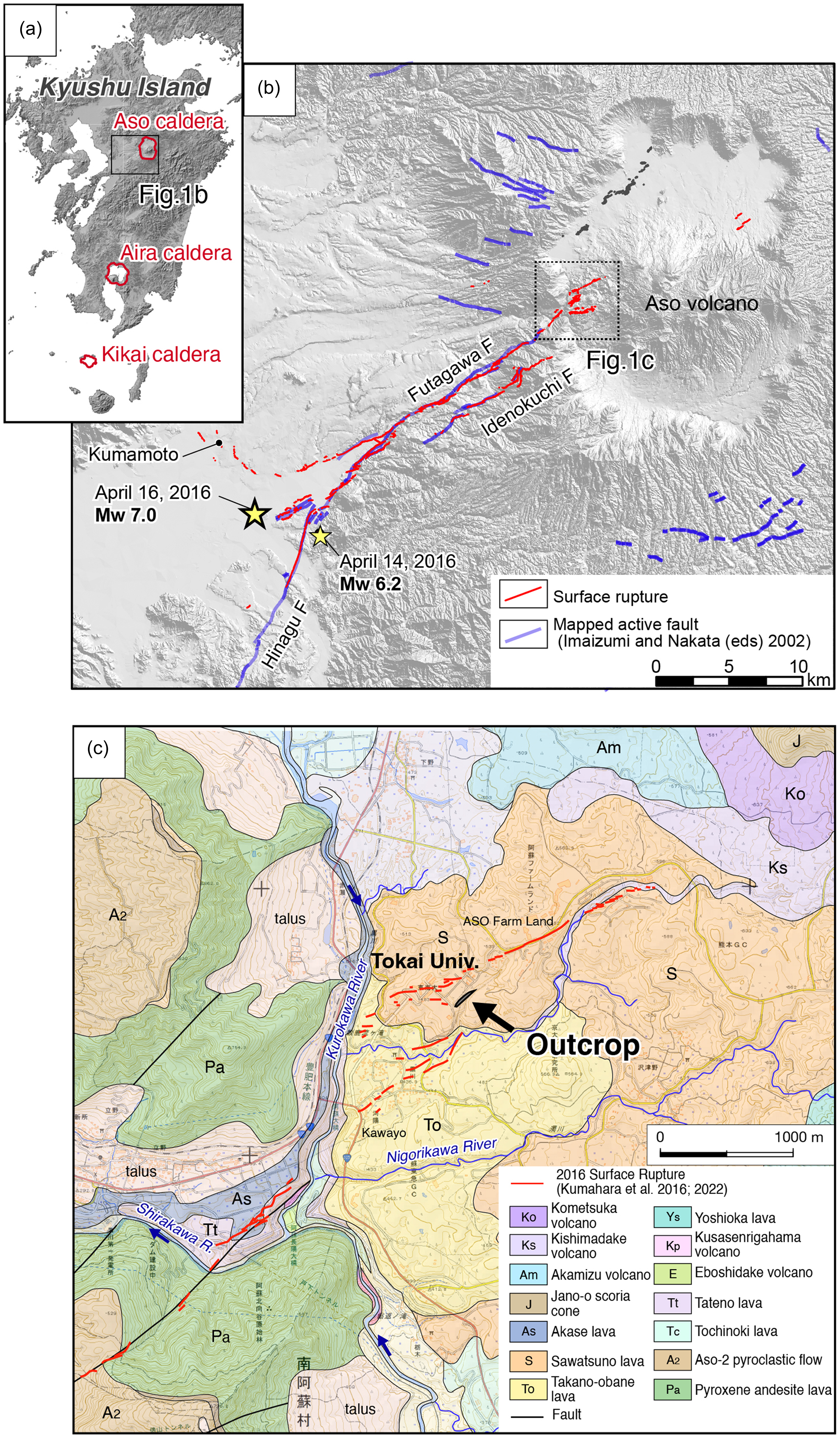
The 2016 Kumamoto Earthquake was a series of events, with a Mw 6.2 earthquake (foreshock) on April 14, a Mw 7.0 earthquake (mainshock) on April 16, and subsequent aftershocks (Figure 1b). As a result of the Mw 7.0 mainshock, a surface rupture of approximately 34 km appeared along the eastern part of the Futagawa fault system and the northernmost part of the Hinagu fault system (Kumahara et al. Reference Kumahara, Kaneda and Tsutsumi2022; Shirahama et al. Reference Shirahama, Yoshimi, Awata, Maruyama, Azuma, Miyashita, Mori, Imanishi, Takeda, Ochi, Otsubo and Asahina2016; Figure 1b). Both Futagawa and Hinagu faults together form a distinctive ENE-NE-striking, right-lateral active fault system approximately 150 km long. These surface rupture zones from the Kumamoto Earthquake destroyed and damaged numerous houses, roads, and large structures, including a dam reservoir, suspension bridge, power transmission towers, and mid-rise buildings. One of the latter was Building #1 at the Aso Campus of Tokai University, located near our study site (Figures 1c and 2). Since the surface breaks within the Aso caldera were not recognized in any previously published maps, trench excavations (Toda et al. Reference Toda, Torii, Okuno, Konno, Ono and Takahashi2019; Ueta et al. Reference Ueta, Miyawaki, Iemura, Yokoyama and Miyawaki2018) and geomorphic data analysis (Aoyagi et al. Reference Aoyagi, Higashi, Homma, Mukoyama, Sugiyama and Hijikata2021) have been conducted in areas where the 2016 surface faults extended. In addition to tectonic surface faulting, earthquake-generated liquefaction and lateral spreading, which mainly occurred in artificial filled areas along nearby riverbanks and former river mouths, as well as landslides and slope failures of loose volcanic soils in the vicinity of Aso caldera (Hazarika et al. Reference Hazarika, Kokusho, Kayen, Dashti, Fukuoka, Ishizawa, Kochi, Matsumoto, Furuichi, Hirose, Fujishiro, Okamoto, Tajiri and Fukuda2017; Kimura et al. Reference Kimura, Sakai, Tanaka, Nagakura and Matsuya2023), produced features resembling surface faulting. These “non-tectonic faults” (e.g., Yokota et al. Reference Yokota, Nagata, Yokoyama, Tajikara and Nozaki2015), especially those associated with thick and young volcanic sediments, often obsure and disturb tectonic ruptures that extend from seismogenic depths. Although such frequent deposited volcanic units allow us to interpret surface-rupturing paleoseismic events in trench walls, they are prone to deformation under strong ground motion, which can hinder the reconstruction of stratigraphy and the history of fault movements.
Locations of the study area and outline of the 2016 Kumamoto Earthquake, central Kyushu. (a) Locations of three major calderas: Aso, Aira, and Kikai. These calderas produced the key tephra units Kusasenrigahama (Kpfa), Aira Tn (AT), and Kikai Akahoya (K-Ah), respectively. (b) Distributions of the epicenters of the Mw6.2 foreshock and Mw7.0 mainshock, and the spatial relationship of the mainshock surface rupture (red lines, Kumahara et al. 2022) with previously mapped active faults (blue lines, Nakata and Imaizumi Reference Nakata and Imaizumi2002). (c) Geological map of the Aso caldera (Ono and Watanabe Reference Ono and Watanabe1985).

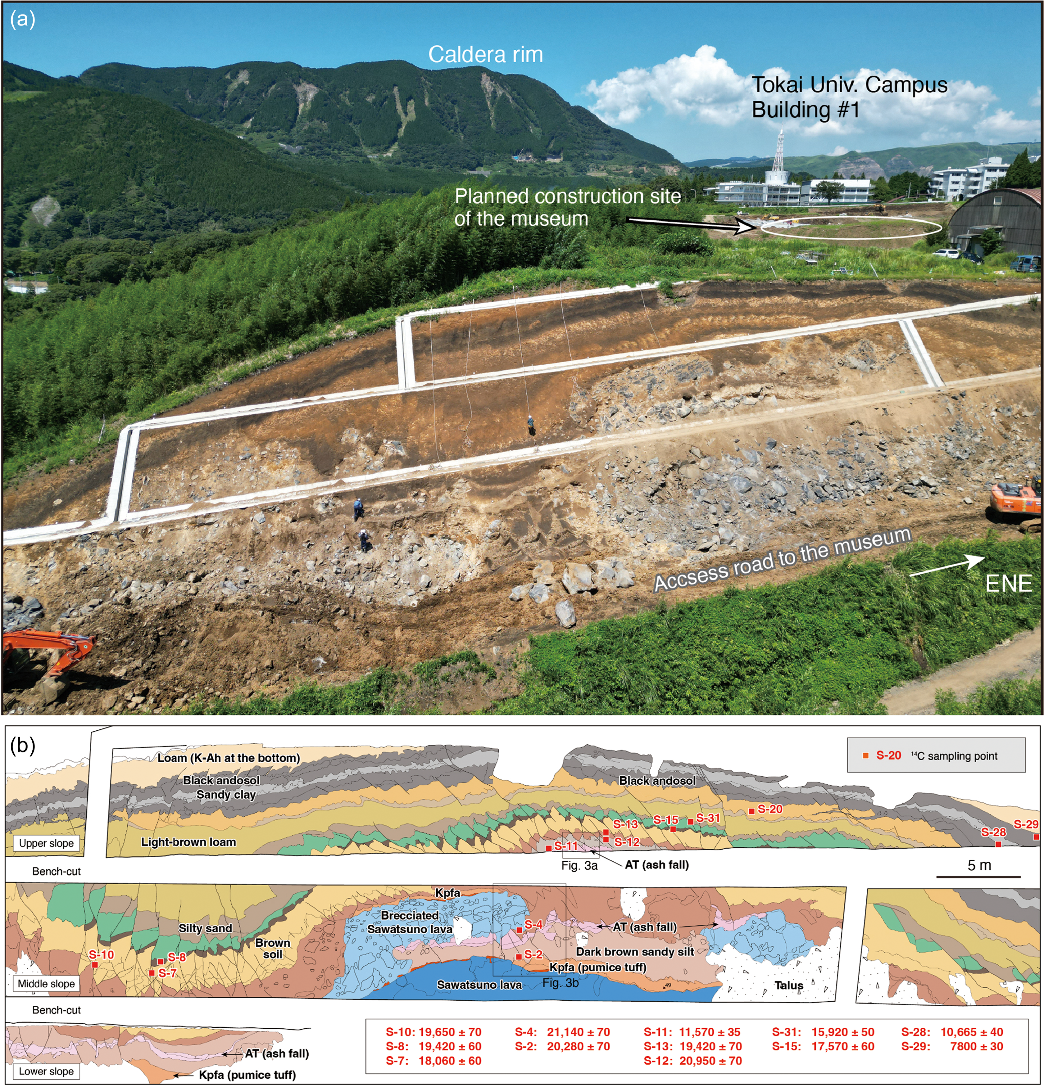
Photo and log of the outcrop. (a) Drone photo showing the locations of the large outcrop, the damaged Building #1, and the Kumamoto Earthquake Museum “KIOKU.” The photo was taken in August 2022. (b) Log of the deformed and faulted sedimentary units and underlying lava exposed in the outcrop. Red squares with sampling numbers indicate the sampling points for radiocarbon dating. The corresponding measured ages are shown in the box at the lower right.

Here we demonstrate the radiocarbon dating, combined with tephra identification, played a key role in identifying the stratigraphic duplication, possibly caused by the hidden surface faulting, on a large outcrop near the damaged Building #1 (Aoyagi et al. Reference Aoyagi, Higashi, Homma, Mukoyama, Sugiyama and Hijikata2021). This building is now preserved as an earthquake relic within the Kumamoto Earthquake Museum “KIOKU.”
Deformed volcanic units and stratigraphic duplication
In 2022, during the construction period of the access road to KIOKU, the road-cut outcrop exposed multiple tephra layers and intercalated paleosols, up to 15 meters thick, overlying massive lava unit, Sawatsuno lava (S: Figures 1c and 2). The overlying sediments are highly deformed, exhibiting large undulations with a wavelength of approximately 20 m, which may correspond to the irregular upper surface of the lava unit. More than 150 shear faults, each clearly displacing the ash and soil units, were identified in the outcrop (Figure 2). This substantial deformation appears to be continuous from the 2016 rupture zone and extends across the Building #1, which sustained severe damage due to ∼40 cm of right-lateral displacement and near-fault deformation with numerous surface fissures (Aoyagi et al. Reference Aoyagi, Higashi, Homma, Mukoyama, Sugiyama and Hijikata2021). Since the Sawatsuno lava has been dated to 27 ± 6 ka using the K-Ar method (Matsumoto et al. Reference Matsumoto, Uto, Ono and Watanabe1991), these highly deformed and complex stratigraphic units were likely formed by several earthquake events since approximately 30 ka.
To constrain the ages of the sediments in this outcrop, three key tephra layers were identified in ascending stratigraphic order: Kusasenrigahama pumice (Kpfa), Aira-Tn (AT), and Kikai-Akahoya (K-Ah) (Torii et al. Reference Torii, Kawaguchi, Toda, Yoshimi, Takahashi, Ishizawa, Aotsuka, Ichikawa, Fujii, Ida, Yoshida, Sakurai, Hara, Kugimiya, Matsuyama, Abe, Terasawa and Okuno2022). These layers are interbedded with thick, sandy volcanic ash deposits erupted from the post-caldera volcanoes of the Aso caldera (Figure 1a, Miyabuchi Reference Miyabuchi2009) and are dated to approximately 32.5 cal ka BP, 30 cal ka BP, and 7.3 cal ka BP, respectively (Albert et al. Reference Albert, Smith, Suzuki, McLean, Tomlinson, Miyabuchi, Kitaba, Mark, Moriwaki, Project Members and Nakagawa2019; McLean et al. Reference McLean, Albert, Suzuki, Nakagawa, Kimura, Chang, Miyabuchi, Manning, MacLeod, Blockley, Staff, Yamada, Kitaba, Yamasaki, Haraguchi and Kitagawa2020; Smith et al. Reference Smith, Staff, Blockley, Bronk Ramsey, Nakagawa, Mark, Takemura and Danhara2013). The age estimates of the three tephras are derived from varved deposit dates bracketing these widespread tephra layers in Lake Suigetsu, located about 500 km northeast of our study area. Based on deformation differences between the stratigraphic units, Yoshimi et al. (Reference Yoshimi, Toda, Torii, Kawaguchi, Takahashi, Ishizawa, Aotsuka, Ichikawa, Fujii, Ida, Yoshida, Sakurai, Hara, Kugimiya, Matsuyama, Abe, Terasawa and Okuno2022) estimated five to seven surface-faulting events have occurred since the emplacement of the Sawatsuno lava. They concluded that the most recent event likely took place after the deposition of the K-Ah tephra. However, due to the repetition of the AT and Kpfa combination in the central part of the outcrop (Figure 2b), unraveling the sequence of events is not so straightforward. A hidden tectonic or landslide plane may have contributed to this duplication. Alternatively, we may have misinterpreted this stratigraphic sequence. To confirm the repeated stratigraphic sequence and unravel paleoseismic events and their timing in such a highly unstable location near the faults, it is essential to date geological units that are often disturbed by deformation and strong ground motion associated with these events. Here we present thirteen (13) radiocarbon (14C) dates of soils and charcoal fragments from this outcrop.
Materials and methods
Geological description
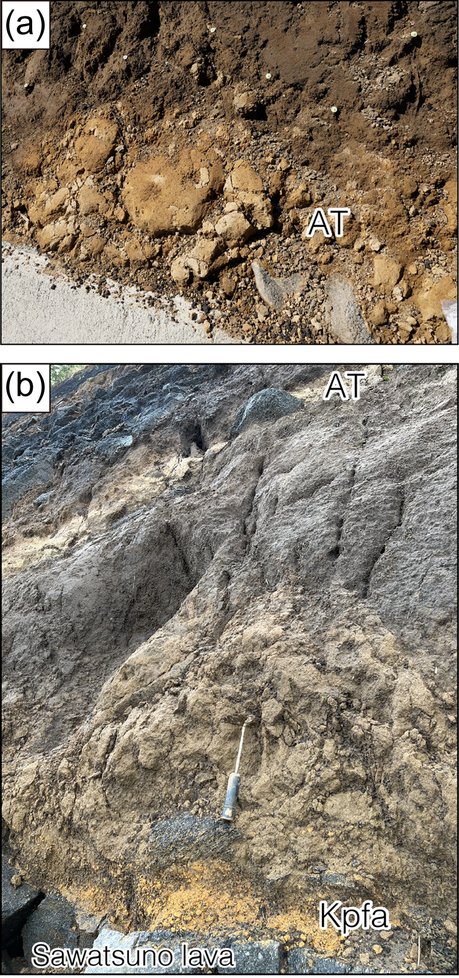
The Sawatsuno lava and Kpfa tephra are identified as pyroxene-bearing dacite (SiO2: 65–67wt.%) in composition (Miyoshi et al. Reference Miyoshi, Sumino, Miyabuchi, Shinmura, Mori, Hasenaka, Furukawa, Uno and Nagao2012). The rock types of the adjacent lavas are biotite-bearing rhyolite (SiO2: >69 wt.%) for Takano-obane (To) lava and aphyric andesite (SiO2: 59–64wt.%) for Tochinoki (Tc) lava, which makes the Sawatsuno lava clearly distinguishable. K-Ar ages of 51 ± 5 ka have been reported for the Tochinoki lava (Matsumoto et al. Reference Matsumoto, Uto, Ono and Watanabe1991), and 64 ± 5 ka (Miyoshi et al. Reference Miyoshi, Sumino, Miyabuchi, Shinmura, Mori, Hasenaka, Furukawa, Uno and Nagao2012) and 73 ± 10 ka (Matsumoto et al. Reference Matsumoto, Uto, Ono and Watanabe1991) for the Takano-obane lava. AT and K-Ah are ash fall deposits associated with ignimbrite that erupted from the Aira caldera and Kikai caldera in southern Kyushu, respectively. They are rich in glass shards and cover a wide area of the Japanese archipelago (Machida and Arai Reference Machida and Arai2003). In this outcrop (Figures 2 and 3), the stratigraphic sequence of the Kpfa and AT tephra layers and the Sawatsuno lava appears to be duplicated. The K-Ah layer overlying the sequence is also slightly disrupted but appears normal.
Photographs showing the AT and Kpfa tephra layer in the outcrop. Locations are indicated in Figure 2b. The same AT tephra layers are duplicated in the upper wall (a) and middle wall (b), likely due to a hidden fault or a landslide surface.

Sampling and AMS radiocarbon dating
In this study, soil and charcoal samples were systematically collected from the upper and middle slopes (Figures 2b and 3). Among these, thirteen (13) samples were treated with acid-alkali-acid (AAA) and their 14C ages were measured by accelerator mass spectrometry (AMS) at Accelerator Analytical Laboratory, Inc. (Japan). The 14C counts, 13C concentration (13C/12C), and 14C concentration (14C/12C) were measured using a 14C-AMS (NEC Corporation). Oxalic acid (HOx II) provided by the National Bureau of Standards (NIST) was used as the standard sample, and background samples were also measured at the same time. The obtained 14C ages (BP) were calibrated to calendar years (cal BP) using the 14C-calendar age dataset IntCal20 (Reimer et al. Reference Reimer, Austin, Bard, Bayliss, Blackwell, Bronk Ramsey, Butzin, Cheng, Edwards, Friedrich, Grootes, Guilderson, Hajdas, Heaton, Hogg, Hughen, Kromer, Manning, Muscheler, Palmer, Pearson, van der Plicht, Reimer, Richards, Scott, Southon, Turney, Wacker, Adolphi, Büntgen, Capano, Fahrni, Fogtmann-Schulz, Friedrich, Köhler, Kudsk, Miyake, Olsen, Reinig, Sakamoto, Sookdeo and Talamo2020) by means of computer software Calib 8.20 (Stuiver and Reimer Reference Stuiver and Reimer1993).
Results and discussion
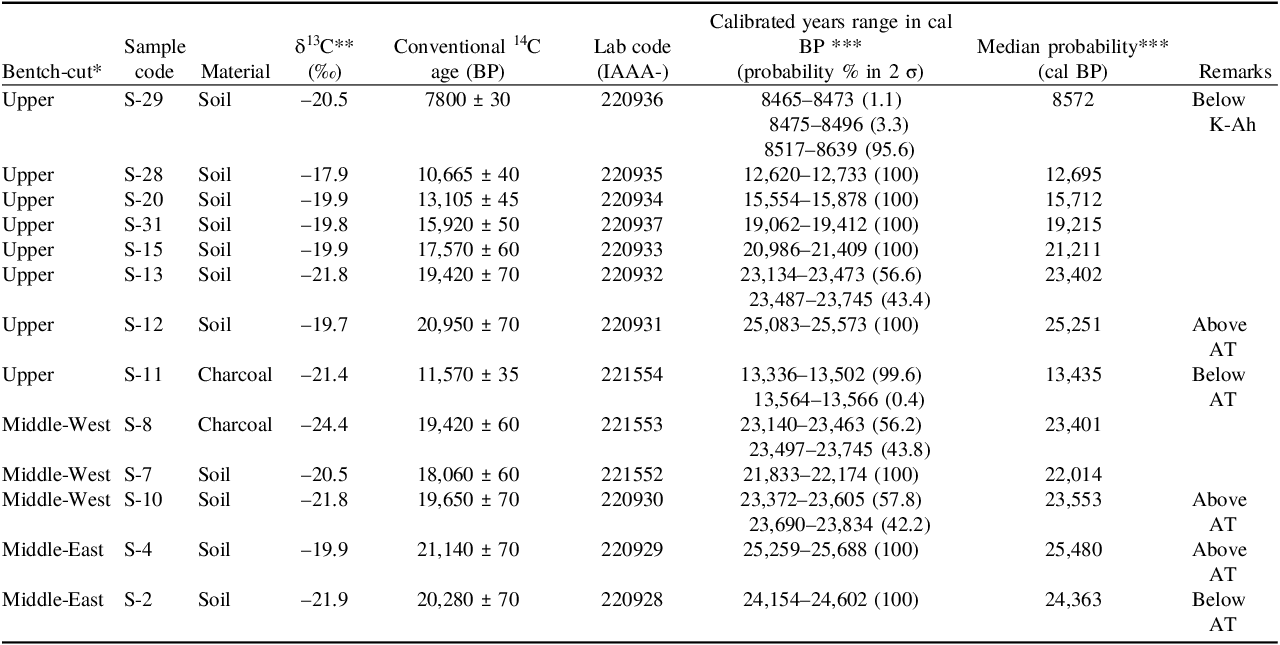
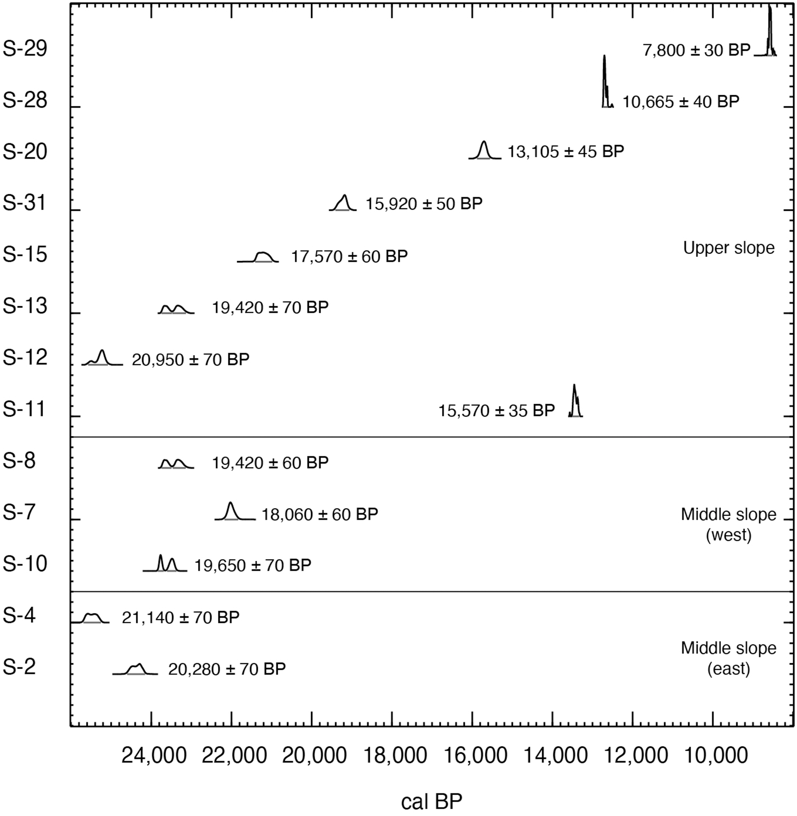
Among the 14C dates of soil samples and charcoal fragments obtained, the ages of seven samples (S-12, -13, -15, -31, -20, -28, -29) on the upper bench-cut are consistent with the stratigraphic relationship between AT and K-Ah tephra layers (Table 1; Figures 2 and 3). However, Sample S-11 just below the AT tephra shows a much younger age. This suggests that a sequence of soil/tephra layers and other geologic units, including the AT tephra and possibly Sawatsuno lava, initially covered the ground surface immediately after ∼13.4 cal ka BP as indicated by Sample S-11 (Figure 4). The timing possibly coincides with the oldest of the four (4) paleoseismic events (4000–1400 BP, 6500–4000 BP, 7900–6500 BP, and 12,400–10,800 BP, Ueta et al. Reference Ueta, Miyawaki, Iemura, Yokoyama and Miyawaki2018) identified from a paleoseismic trench located ∼1 km northeast, on the east side of the Aso Farm Land (Figure 1c).
AMS radiocarbon ages of the soil and charcoal samples obtained from outcrop along road access to Kumamoto Earthquake Museum “KIOKU”

Table 1 Long description
A table comparing radiocarbon ages of soil and charcoal samples from a road access outcrop. The table has 14 rows and 9 columns. Column headers are: Bentch-cut, Sample code, Material, δ13C (permil), Conventional 14C age (BP), Lab code (IAAA-), Calibrated years range in cal BP (probability percent in 2 sigma), Median probability (cal BP), and Remarks. Row 1: Upper, S-29, Soil, -20.5, 7800 ± 30, 220936, 8465-8473 (1.1), 8475-8496 (3.3), 8517-8639 (95.6), 8572, Below K-Ah. Row 2: Upper, S-28, Soil, -17.9, 10,665 ± 40, 220935, 12,620-12,733 (100), 12,695. Row 3: Upper, S-20, Soil, -19.9, 13,105 ± 45, 220934, 15,554-15,878 (100), 15,712. Row 4: Upper, S-31, Soil, -19.8, 15,920 ± 50, 220937, 19,062-19,412 (100), 19,215. Row 5: Upper, S-15, Soil, -19.9, 17,570 ± 60, 220933, 20,986-21,409 (100), 21,211. Row 6: Upper, S-13, Soil, -21.8, 19,420 ± 70, 220932, 23,134-23,473 (56.6), 23,487-23,745 (43.4), 23,402. Row 7: Upper, S-12, Soil, -19.7, 20,950 ± 70, 220931, 25,083-25,573 (100), 25,251, Above AT. Row 8: Upper, S-11, Charcoal, -21.4, 11,570 ± 35, 221554, 13,336-13,502 (99.6), 13,564-13,566 (0.4), 13,435, Below AT. Row 9: Middle-West, S-8, Charcoal, -24.4, 19,420 ± 60, 221553, 23,140-23,463 (56.2), 23,497-23,745 (43.8), 23,401. Row 10: Middle-West, S-7, Soil, -20.5, 18,060 ± 60, 221552, 21,833-22,174 (100), 22,014. Row 11: Middle-West, S-10, Soil, -21.8, 19,650 ± 70, 220930, 23,372-23,605 (57.8), 23,690-23,834 (42.2), 23,553, Above AT. Row 12: Middle-East, S-4, Soil, -19.9, 21,140 ± 70, 220929, 25,259-25,688 (100), 25,480, Above AT. Row 13: Middle-East, S-2, Soil, -21.9, 20,280 ± 70, 220928, 24,154-24,602 (100), 24,363, Below AT.
*See Figure 2
**measured by AMS
***using the computer software Calib 8.20 with the IntCal20 data set.
Probability distributions for multiple samples using the computer software Calib 8.20.

This is also supported by age of another set of samples (S-2 and S-4) just below the AT tephra also showing a slightly younger age. As in this case, the characteristic tephra and lava sequence being exposed repeatedly over a wide area, is unlikely to be a result of multiple eruptions. Therefore, we can conclude that the repeated stratigraphy we observe is likely due to a near-surface tectonic process, such as hidden faulting or a small-scale local landslide, possibly triggered by strong ground motion. However, due to the limited exposure, the potential plane that caused the duplication is indiscernible, making the mechanism inconclusive. In that case, if our detailed dating analysis had not been performed, these tephra layers would have been considered products of different eruptive events, without accounting for a disruptive event possibly associated with a paleo-earthquake.
Summary and implications
The recurrent probability distribution of calibrated dates for multiple samples allows us to confirm that AT tephra and Sawatsuno lava sequence is repeatedly exposed, as macroscopically observed in the field. Systematic dating enables us to identify apparent “anomalous” age values. However, when clearly stratigraphically contradictory age values are obtained individually, the possibility of contamination with younger carbon or measurement errors may be considered.
Acknowledgments
The Aso Regional Development Bureau of Kumamoto Prefecture provided various services, including data provision, during the field survey. Ryohei Aotsuka, Masahiro Fujii, Takafumi Ida, Takumi Yoshida, Maito Sakurai, Yasuo Kugimiya, Hisanori Matsuyama, Kohei Abe and Shuji Terasawa (OYO Corporation, Japan) participated in the field survey and helped with sample collection for radiocarbon dating. Robjunelieaaa Lim (DOST-PHIVOLCS, Philippines) provided proofreading the preliminary draft of this manuscript. Part of this research was funded by a Grant-in-Aid for Scientific Research from the Japan Society for the Promotion of Science (Project Number: 22H01305) and research fund provided by the OYO Corporation. This manuscript was significantly improved by the comments of the editors and anonymous reviewers.