Umm al-Aqarib: location and history of excavations
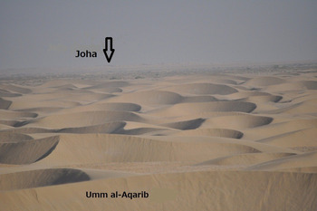
The site of Umm al-Aqarib is situated in the semi-desert area 15 kilometres to the west of the town of Alrifaiy, and six kilometres to the south-east of Jokha (traditionally identified as ancient Umma), in a rural area belonging to the Dhi-Qar Governorate of Iraq. It lies 100 kilometres north of the city of Nasiriyah, and approximately 300 kilometres away from Baghdad. Its location is 45.80° longitude and 31.60° latitude, 4.5 metres above sea level. The site covers more than five square kilometres and is covered with sand dunes, which hampered our attempts to draw a detailed map of the site. During summer, the seasonal winds called “Al-Simoom” also affected our excavations (Fig. 1).
Umm al-Aqarib (ancient Gišša) covered with sand-dune. The photograph also shows the location of Jokha (ancient Umma).

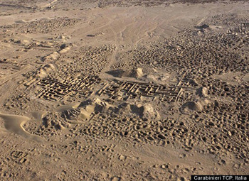
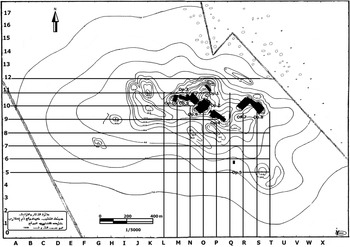
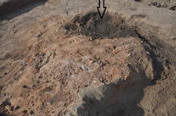
Umm al-Aqarib consists of a series of twenty-one mounds, the highest of which is about twenty metres above the level of the plain while others reach fifteen or eighteen metres. Some of the mounds are black in colour. We noticed the remains of pottery kilns as well as fragments of burnt pottery. Some of the mounds had very hard surfaces, especially in the region that we later identified as the temple area. This hard surface seems to have been a result of burying the temples with mud bricks sometime in the third millennium. Numerous pits made by looters are spread all over the site. These pits have seriously changed the topography of the site (Fig. 2).
Umm al-Aqarib in August 2003 (Tucker Reference Tucker2009). Illegal digging destroyed the site.

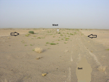
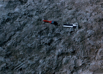
As will be discussed later, Umm al-Aqarib is essentially a site of the Early Dynastic III period. In our surface survey, however, we traced remains of Parthian and/or Sasanian date to the north and north-west of the site. Here we also found a canal ten metres wide, which ran from west to east, and had two small branches (Fig. 3). Some rich coffin graves dated to this period were also found here.
A trace of an ancient channel of 10 m wide, probably dated to the Parthian and/or Sasanian periods.

The site was first described in detail by the traveller John Punnett Peters toward the end of the nineteenth century. He noted that the site seemed “to be more important than Yokha (= Jokha), although not so large. It is not so much covered with sand-drift, for Yokha requires a guide to find it while Umm al-Aqarib shows two considerable elevations”. Peters found the remains of baked bricks set in bitumen as well as stone bowl fragments and flints. There were “long lines of brick walls” and “many more signs of graves” (Peters Reference Peters1897: 333–34).Footnote 2
On October 17th 1935, the site was listed as a property belongs to the Iraqi government. It was officially registered as an archaeological site in the national newspaper Al-waqa‘a Al-iraqia, with the number 1465.
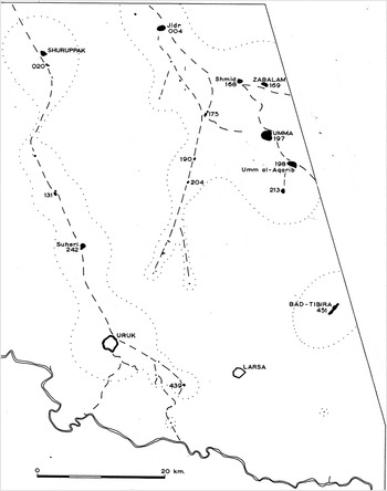
During the early 1970s surveys, Robert Adams and Hans Nissin have gave Umm al-Aqarib the number 198 in the survey's catalog. They drew a map which shows the locations of several sites of the late Early Dynastic period including Umm al-Aqarib (Adams and Nissen 1972: 16, fig. 6) (Fig. 4). Unfortunately, however, this map fails to demonstrate that Umm al-Aqarib was larger than Jokha in the late ED III.)
Map showing Umm al-Aqarib and other sites in the ED III period (after Adams and Nissen Reference Adams and Nissen1972: Fig. 6).

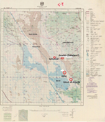
In 1999, the State Board of Antiquities and Heritage decided to excavate the sites of the so-called “Umma region” in order to rescue them from extensive looting. The excavations were conducted at Umm al-Aqarib in 1999–2002 and 2008–2010, at Jokha in 1999–2002, at Schumid in 2001–2002, and at Ibzeikh in 2001–2002 (Fig. 5).
Map of the so-called “Umma” region. Drawing made by the Iraqi Army. Although the date of this map is unknown, I believe it was drawn around a half-century ago.

Dr. Donny George was the field director in the first and second seasons at Umm al-Aqarib (1999–2000), and I participated in the excavations in those years. I was responsible for the expedition in the third and fourth seasons (2001–2002), and Mr Taha Kerim led the excavations in the last three seasons, the fifth to seventh (2008–2010). We have already published a small note on the first two seasons, specifically on our uncovering of “Temple H” (D. George and Haidar Abdul Wahed Reference George, Abdul Wahed and Werr2002). Here, I will give a much more detailed description of the public buildings, including “Temple H”, and of the nearby areas.
Difficulties in the excavation procedures at Umm al-Aqarib
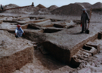
Several difficulties that affected the excavations should be noted. We were faced with an acute lack of equipment and facilities, with evidence of extensive looting and with the theft of many finds. This has led to major problems with recording the finds. The excavations took place in extremely difficult conditions and many of the finds were destroyed.
We spent the first season, from May to August 1999, in preparations for digging. Immediately, we were confronted with a miserable financial situation and with problems of extremely poor facilities. We were given one very old car for the two excavation teams (the Jokha team and the Umm al-Aqarib team). Sometimes we were obliged to rent a car (very old too), because our campaign house was located thirty kilometres away from our sites. We had to drive the car more than one hour (more than three or four hours on rainy days) on the unpaved road from our house to the site. When the weather was very bad, we could not leave our house for two or three days, because the road to the site became extremely muddy, sticky and unsafe. In addition, there was another kind of difficulty. Many archaeological sites in this area were then under attack from thieves. Jokha and Umm al-Aqarib were especially hard hit, as they became the main targets of illegal diggings in 1994 and after. It was for security reasons and also for reasons of availability of facilities that our work house needed to be located at such a distance from the site. If we had set the house near the site, we would have had neither water nor electricity. Even at our location thirty kilometres from the site we needed to bring drinking water from another city almost fifty kilometres away. Very little electricity was available in our house, and we experienced many other difficulties in our daily life there.
We had no modern equipment, no theodolite and no total station. Our cameras were too primitive to take good photographs of the excavated buildings and artefacts. We did not have access to a computer, so our documentation work remained very primitive. We did not have a laboratory to make any analyses of the materials that we found, either in the field or at the Iraq Museum.
In the last year of our work before the outbreak of the war (2002), we were in a hurry to send finds to the Iraqi Museum, because Iraq was making preparations against the impending war. Eventually, however, we lost the materials themselves, because our house was burnt down in April 2003 during the war. When we returned to our excavation in 2008–2010, the topographical features of our site were completely changed as a result of the illegal digging that happened in 2003–2004. We faced a vast challenge to our fieldwork, since thieves had dug thousands of pits, some of which were more than five metres in length and four metres in depth. Thieves had also traced our previous excavations, resulting in serious damage to the excavated structures. (Luckily, we had not fully excavated the temple area, so that the area had not been too badly damaged.) All of these disturbances and disruptions might have caused some lack of accuracy in our evaluation of the contexts of objects.
Excavation Operations at Umm al-Aqarib
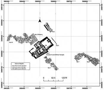
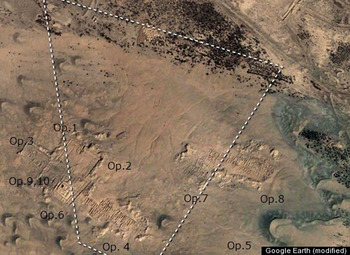
Work was carried out in ten Operations, listed below. The term “Operation” refers to the work in specific locations (Photo 4, Fig. 6, and 7). At times, the work at a given Operation took place over several different seasons. We adopted this simple system of naming because of our inability to map the extensive site in a standard way, due to lack of equipment under the embargo. The Operations, each discussed in more detail below, can be summarized as follows:
Umm al-Aqarib contour map with excavation Operations.

Plan of the excavation Operations.

Operation 1. Square O10 on the contour map. Excavation was carried out at one of the mounds in the center of the site. The excavation revealed a few architectural remains in the first season; when we extended to the east in the seventh season, however, we unearthed a buttressed wall of plano-convex mud bricks as well as some buildings, one of which seemed to be of major significance.
Operation 2. South centre of Square O10 on the contour map. This Operation was located to the south of and close to Operation 1. Here a wall was found, some 63 m in length, probably surrounding the central part of the city or a sanctuary area. A later well penetrated the wall in the middle of the investigated area.
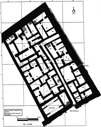
Operation 3. Square N10 on the contour map. Excavation revealed the remains of a vast administrative structure, which we identified as the palace. The building's area is some 50 × 29 m. Its northern wall extended 10 m beyond the excavated area, at which point it was washed away, while its southern wall extended still further.
Operation 4. Squares O9-P9 on the contour map. Located just to the south of the White Temple. Here we discovered a large number of houses with many graves.
Operation 5. Square Q8 on the contour map. Located still further to the south. This area was investigated because in the surface survey of the site we found some broken Ubaid or Uruk sickles. Here we identified some very thin walls on the surface and some graves, probably of Early Dynastic III date. Interestingly, we found nothing but clean alluvial clay a further 2 m below them.
Operation 6. Squares O11, O10 and P10 on the contour map. This Operation included the two large public buildings which we named Temple H and the White Temple respectively. Operation 6, which is located to the south of the palace (Operation 3) and west of the large wall (Operation 2), represents the central area of the site. Temple H was excavated in the second and third seasons, while the White Temple was excavated in the third, fourth and fifth seasons.
Operation 7. Square Q9, 10-R10 on the contour map. Located outside the central part of the city, to the east. Excavation was carried out here in order to study the graves on the site. Two levels were discovered here with many structures and graves; both levels probably date to the Early Dynastic III period.
Operation 8. Square R10, S10, S9 on the contour map. We wished to excavate part of the site further from the centre and the eastern mound, which is the most distant part of the site in the east, was selected for this. Here, multiple structures were discovered with a large group of associated graves.
Operation 9. Square N10 on the contour map. This Operation lies to the west of Operation 3 (palace). In this area, which probably represented administrative buildings, we discovered a large basin of bitumen, one large kiln, two large grain storage rooms and many tablets.
Operation 10. Square N10-M10 on the contour map. Located to the west of Operation 9, and apparently belonging to the same period. We found more administrative buildings, with similar functions to those in Operation 9, as well as large numbers of tablets.
Operation 1: Square O11 (Figs. 9–11)
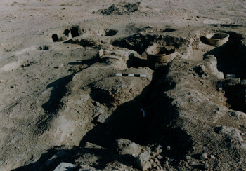
Dr. Donny Gorge and I excavated four squares in this area in the first season (1999). Here we found a wall that belonged to the top level. It had been destroyed by vertical sewage drains, and in places by horizontal sewage pipes (Fig. 12). The level associated with the wall had been completely washed away, and unfortunately we were not able to draw any plan of this mound during our excavation in the first season. J. N. Postgate met with a similar problem in dating such vertical sewage drains at Abu Salabikh. He assumed that a level at least 2 m thick had been washed away from the present surface of the site (Postgate 1994). This also seems to be the case at Umm al-Aqarib, and similar observations have been made at Ur and Fara. It is rather difficult to determine the date of the drains at Umm al-Aqarib, simply because any floors or objects related to them are no longer present, except for sherds packed around them. These sherds are a mixture of those of different levels, some from early and some from later levels. Noteworthy is that the sherds from later levels are similar to those found in the “early Akkad period.” Certainly, some complete small shallow, buff-coloured conical bowls were found inside the drains are typical of the “early Akkad period.” However, we still cannot offer any decisive concrete evidence about dating of the drains. What we can say at present is that drains are found not only in the large courtyard of the White Temple but also in almost all other parts of the site. This seems to suggest that the city was almost abandoned once, and later was reconstructed and prospered again, and that the last period of occupation in the city is the “early Akkad period”, that is to say during the reign of Lugal-zagesi.
Umm al-Aqarib in March 2003 (Tucker Reference Tucker2009). The photograph shows Operations 2–8, excavated before 2003, and Operations 1, 9 and 10, not as yet excavated in 2003.

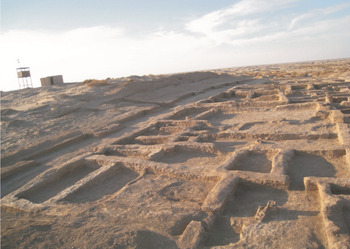
General view of the plan excavated in Operation 1 in 2010. Photograph taken from south-east.

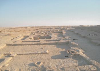
General view of the plan excavated in Operation 1 in 2010. Photograph taken from north.

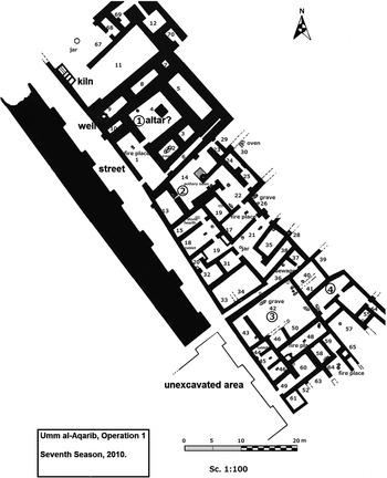
Plan of Operation 1.

Part of Operation 1. The excavation made by Donny George in 1999 revealed vertical sewage drains and walls.

Questions naturally follow: where did the people live after the first abandonment of Umm al-Aqarib, and how long was it before the city was rebuilt? It was in order to address the second of these questions that we concentrated our work in the central area of the site.
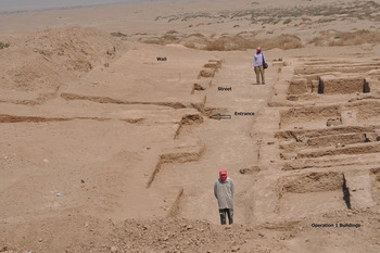
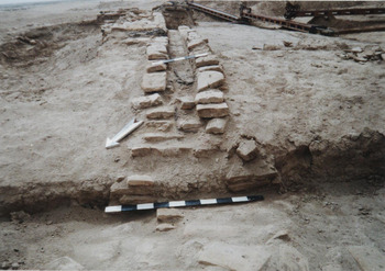
The most recent excavations, in 2010, revealed a buttressed wall to the east of our previous excavation within Operation 1. The excavated part of this wall was c. 83 m long, more than 6 m thick and 1 m high. Nine decorated buttresses were set on its eastern side, and each was c. 3.1 m wide, with intervals of about 6 m between them. The wall itself was constructed of plano-convex mud bricks, laid in a herringbone pattern. The wall was separated from some buildings by a street running from north-west to south-east. The street was c. 5.2 m in width, becoming gradually narrower toward its south-eastern end, to a width of about 2.7 m (Fig. 13). A narrow gate of 1.5 m in width probably led from here to the temples, and to the other areas uncovered inside the wall.
Street located between a thick wall and Operation 1 buildings.

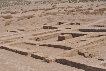
We excavated at least four independent buildings or houses on the eastern side of this street. We believe the first building (Building 1, Rooms 1–9) to be the most important, since its walls were rather thick and very well preserved (Fig. 14). We unearthed two occupation levels and found the same plan in each level. A wall only 30 cm high was associated with remains of this structure, most of which had been washed away. We could not recognize any doorways between rooms, excepting the main entrance and a doorway into Room 4 from the court. This was possibly caused by rebuilding: when later inhabitants decided to build their houses following the old plans, they probably blocked the doorways in order to strengthen the old walls as foundations. Rooms were rectangular in shape surrounding a broad courtyard. In the courtyard were two fire places of baked plano-convex bricks and a table of mud bricks, similar to those found at Room 40 in Operation 9 and at Room 99 in Operation 10.
Building 1, Operation 1.

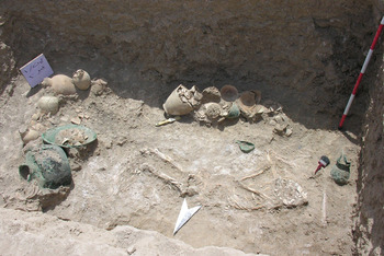
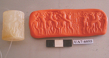
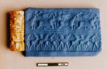
In Room 9, on the western side of the courtyard, a small well of c. 1.5 m in diameter was constructed with baked plano-convex bricks. (We unearthed a well similar to this within the temple area.Footnote 3 ) Another important find in this building was the grave of an influential person. It was remarkably well equipped with pottery, five copper/bronze objects, and an alabaster cylinder seal bearing a combat scene with an inscription: 1) me-abzu-si, 2) AN.ŠARA2.LU2:E2.DILMUN (Figs. 15 and 16).Footnote 4
A rich grave discovered in Room 2, Building 1 of Operation 1. (see Fig. 11 Plan of operation 1)

Cylinder seal found in Grave 1, Building 1 of Operation 1.

The rooms located to the north of this building are also noteworthy (Rooms 11–12, 67–70). Although it is still open to discussion whether they belonged to the first building or to another independent building or buildings, occupants of the rooms seem to have held some social importance, both because large kilns and storage jars were set in the rooms and because the walls of the rooms were remarkably thick.
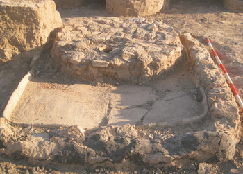
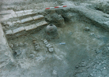
The second building (Building 2, Rooms 13–37) is located to the south of Building 1, and was equipped with many hearths and tanurs in its rooms (or courtyards). It was built entirely of mud (tauf), and was very well preserved. Notable here is that this building contained three floor-levels belonging to a single occupational level. Room (or courtyard) 14 was equipped with a large sunken pottery basin, rectangular in shape. The basin measured 2.25 × 1.6 m with a curb 5 cm high, and was surrounded by baked bricks laid on edge. The bricks were plastered with bitumen. On the southern side of the basin was a vertical sewage pipe; standing higher than and surrounding this pipe were small baked bricks forming a circular floor 0.9 m in diameter (Fig. 17). A hearth of bricks and two tanurs were also set in this room.
A pottery basin surrounded by bricks plastered with bitumen.

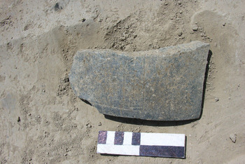
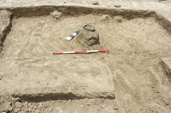
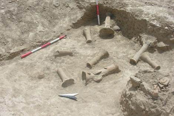
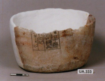
The most important find from this room was a stone fragment with a cuneiform inscription (Fig. 18). This is presumed to be a part of a bowl dedicated to a god.Footnote 5 In Room 15 stood a hearth made of four pieces of basalt, whose shape is rather similar to the baked brick hearths frequently found at other spots of Umm al-Aqarib (Fig. 19). In the second floor-level of Room 17, eight cylindrical pottery stands, a bottle, an ovoid jar, and some conical cups were found close to a round kiln (Fig. 20). Room 18 was also equipped with hearths in its first and second floors, and on the second floor we found a cuneiform tablet mentioning twenty-five potters. On the third floor, one limestone bowl and some pottery vessels were found. On the first floor of Room 35, we found a copper (or bronze) weapon with nails to which wood (probably a part of the handle) is still attached. Other rooms in this building were also equipped with hearths and tanurs, suggesting that domestic activities took place here. In addition, several graves, often accompanied by pottery vessels, were dug from the first floor.
A stone fragment with an archaic inscription, found in Room 14, Building 2 of Operation 1.

A hearth made of four pieces of basalt, erected in Room 15, Building 2 of Operation 1.

A group of pottery stands found in Operation 1.

Building 3, incorporating Rooms 42–50 and 58–66 with their first and second floors, is located to the south of Building 2, and had similar features to Building 2. It had two occupation levels and hearths and tanurs set in almost all of the rooms (or courtyards). The main access to the street was via Room 49. A cuneiform tablet was found in Room 41 and a small oval-shaped piece of gold came from Room 46. Some graves were dug beneath the floors of this building.
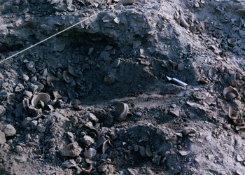
To the east of Building 3 another building was excavated (Building 4, Rooms 40–41, 51–53, 55–57, 64). Its features are essentially similar to the three buildings mentioned above, except that Building 4 was burnt by an intense fire. The fire destroyed some of its walls. Remains of a fallen wall were observed on the floor of Room 41. Directly beneath these remains was found a large amount of clay, a quantity of grains (Fig. 21), a pottery disc, a group of small disc-shaped or irregular-shaped pebbles, a group of oval and round clay lumps, a defaced tablet, and an ovoid jar.
Remains of the burnt wall with a large quantity of grains in Room 41.

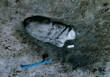
Grave 12, was dug beneath the floor of Room 41, and was accompanied by many pottery vessels, a cylinder seal of semi-precious stone, a big shell, two vessels of alabaster, a lapis lazuli necklace, and a copper (or bronze) vessel with a spout, similar to those found at Grave 1 in Operation 1(mentioned above. P 156, F. 15), Similar objects made of gold were found in the grave of Mes-kalamdug in the Royal Cemetery of Ur (Woolley Reference Woolley1934: 158, pl. 163.). The cylinder seal has two registers; one seems to be a banquet scene, while the other represents animals with one man among them. This grave was probably either for an official who was in charge of this storage room or for the owner of the entire house. Since the skeleton was accompanied by a lapis lazuli necklace and two metal rings, the grave might have belonged to a woman.
Room 55, which we consider to be the smallest, was equipped with an oven. On the floor level were found a mace-head, stone hammers, big pebbles, and a flint with a serrated edge, probably a part of a sickle.
Remains of burnt wood, presumably used for the roof, were observed on the floor of Room 53.
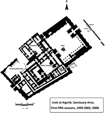
Sanctuary area: Operations 2 and 6 (Fig. 22).
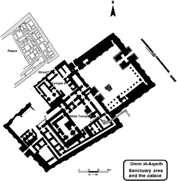
In the central area of the site we discovered three main structures. One was a big wall (Operation 2), and the two structures were identified as temples (Temple H and the White Temple [Operation 6]) (Fig. 22). We believe that this area was a part of the sanctuary precinct dedicated to the chief god of the city, who we assume was Šara, since many personal names incorporating that of Šara are found at Umm al-Aqarib, and the size of the two temples is also very large. (I will give more substantial evidence in support of this idea in a forthcoming article in Al-Rafidān 2014).
Plan of the sanctuary area, big wall, Temple H and the White Temple.

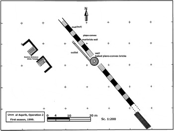
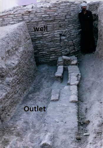
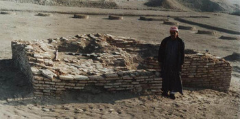
Big Wall: South center of Square O10 on the contour map (Figs. 23 and 24). A large wall was excavated in the first season (1999) under the direction of Dr. Donny George. The wall was placed on a mound 15 m high at the highest point. This was excavated in Operation 2, approximately 50 m to the south of Operation 1. In this area there was a well, cylindrical in shape and 4 m in diameter, the diameter of the mouth being 1.25 m (Fig. 25). This well was dug to a depth of 6 m, but we think it was originally somewhat deeper. In its north-western side there was a vertical aperture, 1 m high. We noted that this aperture was blocked at a later time. There was also an outlet, probably connected to the well. The outlet was constructed of baked bricks and bitumen, and also mud as mortar, and was probably covered by a line of bricks. It remains unclear whether or not this well was constructed later than the outlet, since the latter was erected on the floor aligned with the floor of the temple. If the answer is in the affirmative, we would be dealing with an unusual, non-defensive wall that worked for some religious practices. We think rather that the well is older than the wall. Another well with its long outlet was revealed in the White Temple in our fourth season of excavation. This latter well was undoubtedly constructed later than the wall of the temple, because it destroyed a part of the temple walls. The two wells discussed here, found in Operations 2 and 6 respectively, were constructed in a similar way and with the same materials.
Wall of 63 m long surrounding either the central part of the city or the Sanctuary area.

Plan of Operation 2, located to the east of the White Temple.

Cylindrical well with a small outlet of baked plano-convex bricks.

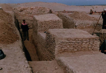
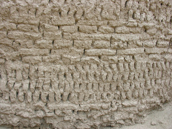
In this mound we unearthed a huge stretch of wall that was about 63 m in length and 3 m in width at its base, and 2 m in height. A part of this wall was just beneath the mound surface. This is a quite distinctive structure; no similar constructions have as yet been found in other Mesopotamian cities. The massive wall has eight towers built of plano-convex mud bricks (28 × 18 × 5 cm). They are not laid in a herringbone pattern, and between each tower is a mass of clay (tauf), with traces of the builders’ fingers still visible on the clay (Fig. 26).
Mass of clay (tauf), with traces of the builder's fingers still visible on the clay.

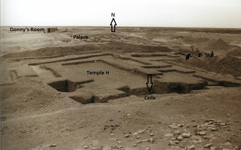
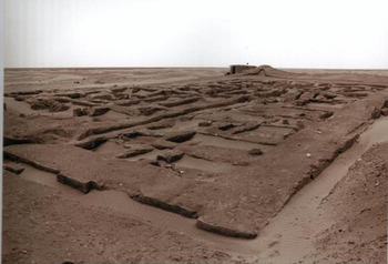
Operation 6 [Temple H]: Squares N10–O9 (Figs. 27–29). A large part of this building, which we identified as a temple, was excavated by Dr. Donny George during the second season (2000), while some rooms or large halls located at the north-eastern side were unearthed in the third season (2001).
General view of Temple H. Photograph taken from south.

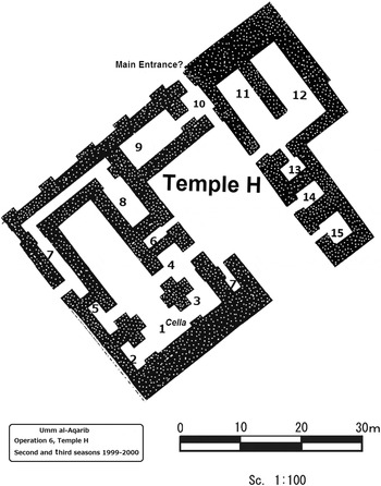
Plan of Temple H in Operation 6.

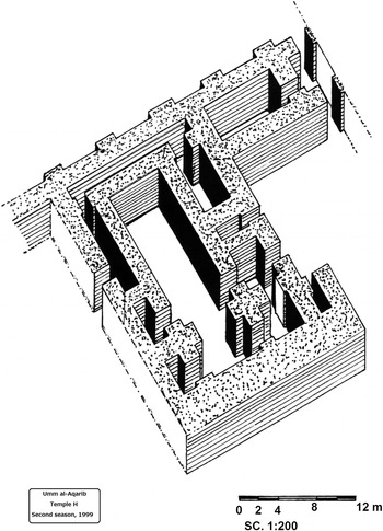
Isometric reconstruction of Temple H.

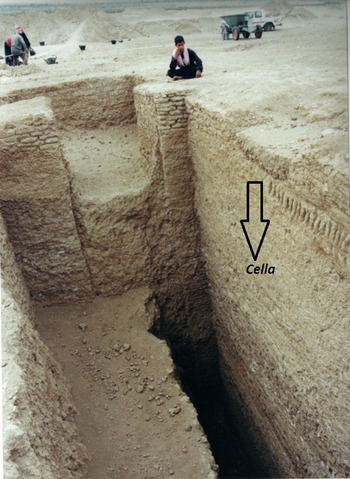
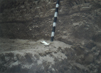
The temple, which was named Temple H after the excavator (myself) by Donny George, was constructed of plano-convex mud bricks in the well-known Sumerian technique of laying courses of mud bricks in a herringbone pattern. Based on this evidence, we immediately concluded that the temple should be dated to the Early Dynastic period. It was apparently earlier in date than the White Temple. The floor of Temple H was 2 m lower than that of the White Temple, as we could see from the two soundings made in the highest part of the two temples. We dug a deep trench in the southern half of the cella of Temple H, and from this we estimated the height of the walls as approximately 7 m (Fig. 30). Nothing was found in this trench except clean soil, broken mud bricks, and a small conical cup at a depth of about 3 m.
Wall of 7 m high at the cella.

All the walls of the temple are c. 1.5 m thick excepting the southern wall, which was about 3 m thick. The central part of the temple has a courtyard (6 × 16 m) and a cella (6 × 4 m). Another courtyard that was the largest in this temple was located to the east.
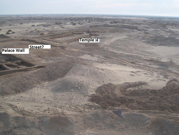
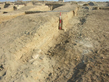
The outer wall of Temple H had a series of buttresses on the inner face. Its main entrance probably led to a street, 12 m in width (Fig. 31), which separated the sanctuary area (Temple H and the White Temple) from the secular area (the palace and the administrative buildings). At a later date Temple H was deliberately buried with mud bricks and clean soil, which covered all of its constituent parts. We saw that the same happened in the White Temple.
Open space or a street separating Temple H from the Palace.

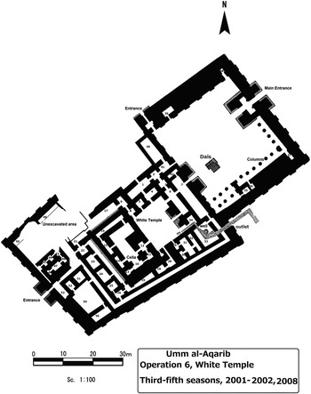
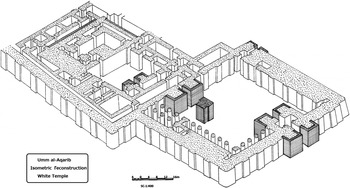
Operation 6 [White Temple]: Squares N9–10, O9 (Figs. 32–34). The main structure that we named the White Temple was excavated in the third, fourth and fifth seasons (2001–2000, 2008), while its north-western part was left unexcavated because of the very large sand dune that covers this area. In addition, the clean soils with complete and broken mud bricks, which had been brought here in antiquity to bury the temple, made tracing the temple walls extremely difficult.
General view of the White Temple. Photograph taken from east.

Plan of the White Temple in Operation 6.

Isometric reconstruction of the White Temple.

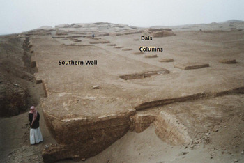
First, I describe the component parts of the building that are dated to the later phase of construction in the White Temple. These include the walls with a central courtyard and a dais (or, less likely, an altar) of bricks (measuring 2 × 3 m), decorated on its east side with two half columns (Fig. 35). Many fragments of lapis lazuli and bronze were also found here. Mud bricks, laid horizontally, capped the highest part of the White Temple (Fig. 36). We were not able to see how far these mud bricks stretched. The capping was probably for the foundation of the later terrace.
Remains of a dais, measuring 2 × 3 m. The dais belongs to the later level of the White Temple.

Remains of plano-convex mud bricks capping a top of the highest part of the White Temple.

A large vertical drain was found in the central part of the large courtyard, which is probably dated to the later levels of the site at a time when the White Temple was no longer in use. In addition, the mouth of a well with its baked brick outlet had partly destroyed the walls of the temple. As we have discussed above, the well belonged to different layers (of different periods?). We found that the same well contained an outlet, and that this outlet had partially damaged the wall. In conclusion, therefore, the top of this well had the same height as the remains of the temple walls, while the walls themselves probably date to an earlier period.
The well, cylindrical in shape (Fig. 37), was made of baked plano-convex bricks of a medium size (16 × 28 × 5 cm) and of a bigger size (16 × 36 × 5 cm). The outer diameter of the well is 2.9 m, the diameter of the water aperture being 0.9 m, while the depth is more than 9 m. The exposed height of this well is 2 m, and it was built on the rectangular terrace, which in turn was built of three courses of bricks. The well was supported by brick fragments of different sizes, and the outlet was also built of baked bricks with mud mortar (Fig. 38). We found traces of a bitumen coating for the outlet. The same outlet was protected outside by an ash layer, more than 2 m wide and 30 cm thick, and containing fragments of large jars.
Cylindrical well, built of plano-convex baked bricks.

Outlet made of baked bricks, joined and plastered with mud and bitumen.

We dug a trench of 3 × 2 m outside the eastern corner of the White Temple to a depth of 3 m. At one meter we unearthed the level contemporary to the floor level of the temple, but here it was covered with baked bricks. Two graves from the ED period were also discovered here at a depth of 2.5 m.
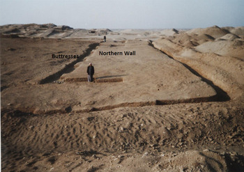
The White Temple of Umm al-Aqarib is the largest temple in Early Dynastic Sumer so far known to us. It measures approximately 152 × 70 m, and so it is calculated to be almost 11,000 m2 in area. Its large courtyard measures 45 × 58 m, and its northern and southern walls are remarkably thick (Fig. 39). According to Hansen, the Oval Temple of Early Dynastic III Lagaš (al-Hiba) might be approximately 130 m in length, on the presumption that it was similar to the Oval Temple at Khafajah in shape (Hansen Reference Hansen1970: 246).
Northern wall of the courtyard, c. 11 m thick, buttressed inside toward the main courtyard of the White Temple.

We decided not to excavate the temple fully, primarily because we seriously feared that the site might be in danger from illegal digging and looting, and because we found it extremely difficult to remove a tremendously large amount of soil.
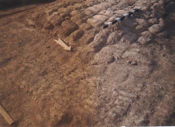
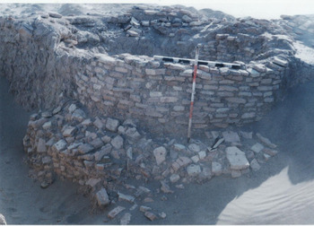
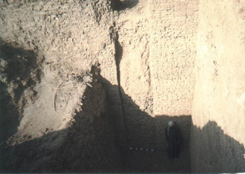
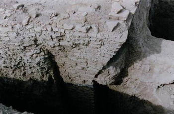
The White Temple was constructed of plano-convex mud bricks laid in courses in a herringbone pattern (Fig. 40). Baked bricks were also used in some places and the mortar for them was mud or bitumen. The surfaces of the walls were plastered with mud and painted with lime. The temple had three floor levels. As a principle, we traced the walls in order to discover the plan of the temple, to a height not exceeding 50 cm. The floors were only uncovered at one of the columns in the courtyard, and the three floors at the gates. We made a sounding of 4 × 6 m at the highest point of the mound so as to examine the possibility of walls of other periods, but we found that all of the walls, which were 8 m high, quite possibly dated to the Early Dynastic period (Fig. 41). Only two rooms were completely excavated.
Wall in the White Temple made of plano-convex mud-bricks, laid in a herringbone pattern.

Sounding made at the White Temple wall of 8 m high, at the highest mound on the site.

The White Temple has a tripartite plan, which is similar to other fourth- and third-millennia temple plans in Mesopotamia, with the so-called “bent axis plan” which can be seen in its cella of Room 10. The same cella is L-shaped and surrounded by further rooms (Rooms 11–16). A similar cella is already found in the E-anna IV sequence in the Stone Cone Mosaic Temple in Uruk (Moortgat 1968: 3, fig. 2).
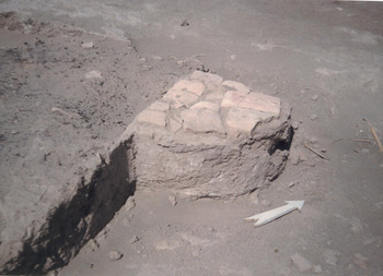
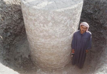
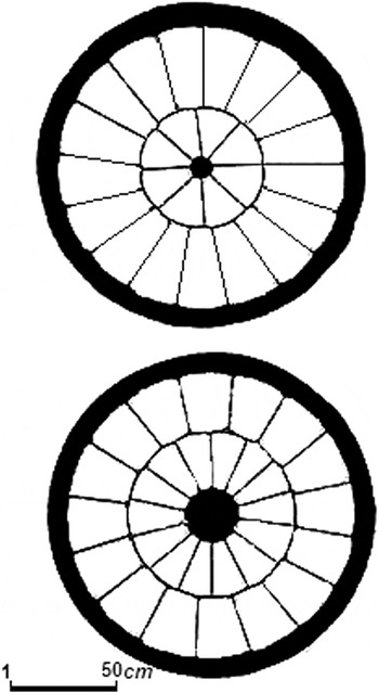
Sixteen cylindrical columns were constructed close to the eastern and southern walls, while one rectangular column with buttresses on its western side was erected at the eastern corner (Figs. 42 and 43). They were probably set so that they might form a shady colonnade or perhaps a small shrine in the open air. Similar pillars were found at Palace A in Kiš (Mackay Reference Mackay1929) and at Royal Palace G in Ebla (Matthiae Reference Matthiae and Holme1977: 68 ff.). It is quite possible that the last six columns, located in the southern part of the court, formed a small shrine or an open-air cella, for there are two buttresses on the east wall forming a niche. Almost identical columns were constructed in Uruk at the end of the level IVb period (Surenhagen 1993). Do these columns suggest that the White Temple was modeled on an earlier Uruk-type temple at Uruk? We must wait for future excavations to answer this question fully, and at present, I only posit that the temples at Umm al-Aqarib follow a very old architectural tradition.
The highest white-painted column (2.25 m high) in the large courtyard of the White Temple.

Sketch showing two different methods of construction of columns of the White Temple.

The general plan of the temple is rectangular in shape, with three large main entrances located on the eastern, western and northern sides. The eastern entrance seems to have been the biggest (2.8 m in width), and was probably covered by a corbel vault, almost half of which can be seen on its eastern side. Bearing this in mind, we estimated its original height as 3.5 m, which permitted us to calculate the total height of the outer wall to be 5.0 m (Fig. 44).
Part of the corbel vault of the main gate of the White Temple.

All the main and subsidiary entrances were strengthened by baked bricks, where mud and bitumen were used as mortar. The outer walls of the temple complex were buttressed. Most of the buttresses were 3.5 m wide and projected 0.5 m from the walls, but some of them, especially those in the southern, western and north-western walls, were less than 3 m apart. The wall that extended towards the east of the northern entrance had no buttresses, which would mean it was the outer face of the court. However, it was buttressed on the inside face. The western wall of the court was also buttressed on the inside.
A foundation brick, bearing a complete duplicate of the first sections of En-metena Cone A-B, (Sollberger Reference Sollberger1956) was found close to the northern wall of the White Temple.Footnote 6 The royal inscriptions called Cone A-B were composed by the order of En-metena, ruler of Lagaš, probably at the near end of the twenty-fifth century or at the first half of the twenty-fourth century b.c. (by the Middle Chronology). The text describes a long history of conflicts between Lagaš and the neighbouring kingdom of GIŠ.KUŠU2.KI (traditionally read as ummaki in the modern Assyriological scholarship). Discovery of this brick inscription suggests that Umm al-Aqarib was temporarily conquered by Lagaš. Since this brick inscription mentions En-metena as the ruler of Lagaš explicitly, it was certainly brought to Umm al-Aqarib when En-metena reigned at Lagaš, most probably at the beginning of his reign. The brick does not seem to have been unearthed in its original location, and may have been moved in antiquity.
One large dais (or, less plausibly, altar) of approximately 5 × 5 m, which was built with complete and broken baked bricks (Fig. 45), was placed within the court, to the east of the subsidiary entrance that gives access to another part of the temple complex with a central court surrounded by a group of rooms. This dais (or altar) was apparently built much later than the construction of the temple.
Dais in the large courtyard of the White Temple made of baked plano-convex bricks. It was donated by Bara-irnun, wife of Gišša-kidu ruler of Gišša.

In my view, Umm al-Aqarib (not Jokha as has almost unanimously been claimed) was the central settlement of the kingdom of Gišša (written GIŠ.KUŠU2.KI) in the Early Dynastic III period. (NB that GIŠ.KUŠU2.KI in the Early Dynastic texts should not be read ummaki [Oraibi Almamori Reference Oraibi Almamori2014].) I also think that the White Temple was the temple of the city-god, Šara. If so, the dais (or altar) we found seems to have been dedicated by Bara-irnun, wife of Gišša-kidu ruler of GIŠ.KUŠU2.KI. A gold plate now housed by the Louvre Museum records that Bara-irnun dedicated a dais (bara2 in Sumerian) to E-mah, temple of Šara (RIME 1 [Frayne Reference Frayne2008]: 371, E1.12.6).Footnote 7 It is, however, still difficult to determine the object on which this gold plate was originally placed and where it stood, though three candidates could be proposed: 1. on the dais (or altar) itself, 2. a chair set on the dais (or altar), 3. a statue on the chair on the dais (or altar) (cf. André-Salvini Reference André-Salvini2003). At some point in its history, the White Temple, as was also the case for Temple H, was buried intentionally and deliberately, with clean soil and mud bricks covering all of its constituents (Fig. 46).
Clean soil and mud bricks, used for burying of the White Temple.

Operation 3 [Palace]: Square N10 on the contour map (Figs. 47–49)
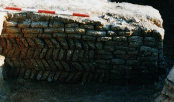
This area was excavated in the first and second seasons (1999–2000). (Additionally, a part of the southern wall with two large rooms was unearthed in the sixth season in 2009. Therefore, we now include this part within the Operation 9 plan.) For excavation, we chose a new mound of about 18 m in height in the central area of the city. After cleaning up and scraping the surface of this mound, traces of fire partly covering the area were revealed, and walls appeared at only 10 cm from the surface. We later identified this structure as the palace. The inner and outer walls of the palace were constructed with plano-convex mud bricks (libn) (22 × 18 × 5 cm), typical of the Early Dynastic period. Pure mud was used as mortar, and the bricks were laid in a well-known herringbone pattern (Fig. 50). We concluded that these walls had been plastered many times while the building was in use, because we discovered on some walls traces of the white paint below the top layer of plaster which was probably lime washed. The practice of painting the walls white is similar to that seen on the walls of the White Temple.
Plan of the palace in the central area of the site. Photograph taken from east.

Plan of Operation 3, the palace.

Plan of the sanctuary area and the palace in the central area of Umm al-Aqarib.

Herringbone pattern seen on the palace wall.

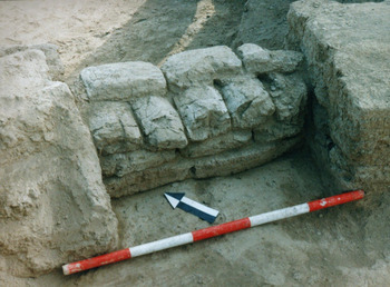
Most of the doorways had been blocked at a later time with mud bricks and mud. This probably happened when people rebuilt the palace, not changing the original plan but blocking these doorways in order to strengthen the foundation as a base for the later construction (Fig. 51).
Blocked doorway unearthed in Room 22 of the palace.

The excavated area of this palace is c. 50 × 28 m. The northern wall was not buttressed and was c. 2.8 m thick. It extended more than 30 m, while the southern wall was buttressed and had a thickness of 2 m (Fig. 52). This wall stretched further into an unexcavated area, which suggests that we have only uncovered a part of the building. An entrance was located within the eastern wall of the palace. Unfortunately, other details were washed away, resulting from the slope of the mound. The eastern wall, c. 2.5 m in thickness, was also buttressed in the same way. Each buttress of these walls is about 1.5 m wide and stood at an interval of c. 5–6 m.
A southern wall of the palace, 2 m thick, extending for more than 30 m.

An entrance located in the southern wall led into the interior of the building through a long corridor, which divided this palace into the eastern and western sections (Fig. 53). The floor of the entrance was paved with a mixture of broken and complete bricks. Four benches are attached to the southern wall close to the southern entrance, three on its east side and one on its west. From a glance at the palace plan, we understood that the building was divided into two sections separated by a corridor. Each section has characteristics of a standard south Mesopotamian house with rooms arranged around courtyards.
Southern entrance and a long corridor dividing the palace in to two sections.

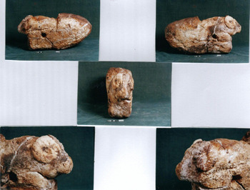
The eastern section had small and large rooms or courts. Room 35, which was completely destroyed by a fire, was apparently the throne room. This identification was supported by a discovery of a limestone ram 41 cm tall, which may have been an armrest of a throne (Figs. 54a and b). This can be compared to a couple of rams found at Ur (Woolley Reference Woolley1934: pls. 87–89). The base of a burnt pillar, made of a palm-tree trunk, was unearthed in a courtyard (Room 37). This courtyard was also destroyed by an intense fire. I consider that the fire, of which evidence is found in Room 35 and nearby, probably represents a political crisis in the city. A tablet, which was written in the nineteenth regnal year (of an unknown ruler) was found in Room 44.
Limestone armrest with a carving of a horned ram, found in Room 35 (probably the throne room) of the palace.

Photographs showing details of the ram-shaped limestone armrest from Room 35.

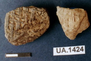
The second section of the palace, located to the west of the corridor, has two occupation levels on the same floor plan. From the layout of this section, as well as other artefacts discovered here, we concluded that this section was utilized as a kitchen that provided services for the other sections of the palace. Some rooms, especially in the northern part of the palace, were equipped with tables or platforms built with mud bricks, and broken bricks capped their tops. Although their function still remains unclear, we can safely assume that some industrial activities took place there. The courtyards of these sections contained hearths in both strata, with other finds such as conical bowls and cups. On the floor of Room 5, probably a courtyard, we discovered many clay lumps with seal impressions (Fig. 55) and two small human figurines of clay. It seems that the clay lumps had been attached to cords and wooden wedges. In Room 8, which was perhaps a storage room, there were two vats, each c. 1.5 m each in diameter, which contained grain remains. One of them was partly destroyed by vertical drains from the later levels. Other finds here were storage jars and some conical bowls standing upside down in Room 27, close to a bench of bricks stepped like a stair (Fig. 56). A hemispherical door socket of limestone, damaged by an intense fire, was unearthed on the floor of the doorway between Rooms 8 and 9.
Two seal impressions with different scenes. It was found in room 5 of the palace.

Palace Room 27 equipped with pottery vessels.

Important finds came from Room 11, located within the same section of the palace. Here we discovered two cylinder seals made of shell. One of these had two registers, following the Early Dynastic III principle (Fig. 57). There was also one half of an alabaster vessel, which had been deliberately cut into halves (Fig. 58).Footnote 8 Another vessel, seriously fragmented, bore a Sumerian inscription with two undamaged lines.
Cylinder seal of the Early Dynastic III period with two registers, found in Room 54 of the palace.

Half of alabaster vessel, probably deliberately cut in half, found in Room 11 of the palace.

On the floor of L-shaped Room 54, five pieces of shell inlay were found. An arm and a skirt among them are quite similar to the inlays of the Standard of Ur and to those from Palace A at Kiš (Mackay Reference Mackay1929: pl. XXXV).
Also within the palace a big lobed pit of 5 × 5 m in size had been dug from a recent surface into Room 1; in this pit many sherds, complete vessels (mostly conical bowls), and animal bones were deposited (Fig. 59). This pit seems to have been dug by the people who used the large arched kiln (which we unearthed in Operation 9), located about 30 m away to the north-west of this pit. The lobed pit is dated to the Early Dynastic period.
Lobed pit dug through the fill of Room 1.

Conclusions
The site of Umm al-Aqarib flourished in the Early Dynastic III period in the middle of the third millennium b.c. We can confidently date the buildings to the Early Dynastic period on the basis of their architectural plans and construction methods, with plano-convex bricks being laid in a herringbone pattern. Almost all the artefacts found substantiate this dating. This dating is also supported by the textual sources found at Umm al-Aqarib and the other nearby sites (Oraibi Almamori Reference Oraibi Almamori2014).
The impressively large sizes of both Temple H and the White Temple suggest that they functioned as important centres of religious (and economic) activity in the Early Dynastic period. The White Temple is indeed one of the greatest temples to have ever been unearthed in Mesopotamian archaeology. It had three large main entrances, the eastern one being certainly arched. Each of the sixteen columns had a diameter of about 1.6 m. These pillars were constructed in two unique ways. The northern and southern walls of the large courtyard were approximately 11 m thick, the thickest wall ever found in Mesopotamian excavation so far. The cella and its hall had an L-shape plan on a very large scale.
In the first and seventh seasons of excavation (1999, 2008), we found two parts of the two different walls that seem to have surrounded both the palace area and the temple area respectively. Each Sumerian city has a political, religious and economic centre, represented by the palace and the temple(s), with a surrounding residential quarter. Umm al-Aqarib had an ideal layout with the public buildings in the city centre.
Someday in the near future at Umm al-Aqarib, we will excavate the remaining parts of Temple H and the White Temple. We will even uncover the other large public buildings (temples and another palace) which, in my belief, are located in a still unexcavated part of the central area of the site. We will then be able to draw a complete picture of the heart of this large Sumerian city. Further work will be carried out on the domestic quarters and will be published in a future article.
An interpretation, until now almost unanimously accepted, is that Jokha, which is very close to Umm al-Aqarib, is the site of the ancient city of GIŠ.KUŠU2.KI called Umma. However, our surface survey shows that Umm al-Aqarib was far more extensive than Jokha in the Early Dynastic III period. Elsewhere (Oraibi Almamori Reference Oraibi Almamori2014), I conclude that Umm al-Aqarib, called Gišša (usually spelled GIŠ.KUŠU2.KI in textual sources), was the central city of the Gišša kingdom. The White Temple is therefore to be identified with the temple of Šara, city god of Gišša.
With the exception of the Parthian and/or Sasanian remains in the north and north-west of Umm al-Aqarib, we did not find any evidence of large-scale occupation later than the Early Dynastic III period. We suggest that Umm al-Ararib was abandoned at the very end of the Early Dynastic III period, and that the political centre was at this point moved from Umm al-Aqarib to the nearby settlement of Jokha (probably ancient Umma).