INTRODUCTION
Seamounts are prominent features of the seafloor throughout the oceans of the world, with 30 000–60 000 large seamounts and over 100 000 smaller knolls and hill features (Costello et al. Reference Costello, Cheung and De Hauwere2010; Yesson et al. Reference Yesson, Clark, Taylor and Rogers2011). Seamounts may support a large number and wide diversity of fish species (see for example Morato & Clark Reference Morato, Clark, Pitcher, Morato, Hart, Clark, Haggan and Santos2007), and can be an important habitat for commercially valuable species, targeted by a number of large-scale fisheries in the deep-sea. Major bottom trawl fisheries include alfonsino (Beryx splendens), black cardinalfish (Epigonus telescopus), orange roughy (Hoplostethus atlanticus), southern boarfish (Pseudopentaceros richardsoni), macrourid rattails (primarily roundnose grenadier Coryphaenoides rupestris), oreos (smooth oreo Pseudocyttus maculatus and black oreo Allocyttus niger) and toothfish (Patagonian toothfish Dissostichus eleginoides and Antarctic toothfish D. antarcticus) (Clark et al. Reference Clark, Vinnichenko, Gordon, Beck-Bulat, Kukharev, Kakora, Pitcher, Morato, Hart, Clark, Haggan and Santos2007). Many of these fisheries, however, have not been sustained. There are many examples of ‘boom and bust’ fisheries and serial depletion of populations (see for example Clark et al. Reference Clark, Vinnichenko, Gordon, Beck-Bulat, Kukharev, Kakora, Pitcher, Morato, Hart, Clark, Haggan and Santos2007; Pitcher et al. Reference Pitcher, Clark, Morato and Watson2010). This type of rapid, yet short-lived, exploitation of deep-sea fishes has raised concerns over whether the fisheries should be pursued (see Roberts Reference Roberts2002; Stone et al. Reference Stone, Madin, Stocks, Hovermale, Hoagland, Schumacher, Etnoyer, Sotka, Tausig, Glover and Earle2004; Norse et al. Reference Norse, Brooke, Cheung, Clark, Clark, Ekeland, Froese, Gjerde, Haedrich, Heppell, Morato, Morgan, Pauly, Sumaila and Watson2011).
Deep-sea seamount fisheries face more problems than just overexploitation. Effects of bottom trawling on the wider demersal fish and benthic invertebrate communities also need to be considered (for example Dayton et al. Reference Dayton, Thrush, Agardy and Hofman1995; Clark & Koslow Reference Clark, Koslow, Pitcher, Morato, Hart, Clark, Haggan and Santos2007). Seamounts can host endemic species (for example Rowden et al. Reference Rowden, Schlacher, Williams, Clark, Stewart, Althaus, Bowden, Consalvey, Robinson and Dowdney2010a ), as well as habitat-forming fauna such as deep-sea corals and sponges that are regarded as indicators of ‘vulnerable marine ecosystems’ (FAO [Food and Agricultural Organization of the United Nations] 2009). The vulnerability of deep-sea fauna has prompted calls from the United Nations General Assembly for improved management of deep-sea fisheries and subsequent development of international guidelines for High Seas trawl fisheries (FAO 2009). Management is therefore required to balance exploitation and conservation, both of fisheries and seamount habitat (Johnston & Santillo Reference Johnston and Santillo2004; Probert et al. Reference Probert, Christiansen, Gjerde, Gubbay, Santos, Pitcher, Morato, Hart, Clark, Haggan and Santos2007; Morato & Pitcher Reference Morato, Pitcher, Nielsen, Dodson, Friedland, Hamon, Musick and Verspoor2008; Clark et al. Reference Clark, Rowden, Schlacher, Williams, Consalvey, Stocks, Rogers, O'Hara, White, Shank and Hall-Spencer2010a ).
Much of the literature addressing issues of deep-sea fisheries has focused mainly on either fisheries (see Clark Reference Clark2001; Bax et al. Reference Bax, Tilzey, Lyle, Wayte, Kloser, Smith and Shotton2005; Francis & Clark Reference Francis and Clark2005; Sissenwine & Mace Reference Sissenwine and Mace2007; Norse et al. Reference Norse, Brooke, Cheung, Clark, Clark, Ekeland, Froese, Gjerde, Haedrich, Heppell, Morato, Morgan, Pauly, Sumaila and Watson2011) or habitat (see Roberts Reference Roberts2002; Johnston & Santillo Reference Johnston and Santillo2004; Probert et al. Reference Probert, Christiansen, Gjerde, Gubbay, Santos, Pitcher, Morato, Hart, Clark, Haggan and Santos2007). In this paper, we attempt to bridge this gap, and discuss what is required for effective management of both fisheries and seamount habitat. We describe the current problems facing fisheries sustainability and habitat conservation, identify potential solutions, and integrate these elements into a spatial approach to fisheries and habitat management. We move beyond simply highlighting the difficulties to proposing aspects of management options that are practical as well as effective. Although pelagic seamount fisheries also occur, management issues are currently focused on bottom trawl fisheries. Hence we restrict the paper to demersal fish, and draw heavily upon on our experience with orange roughy to contribute advice on improving management of seamount resources.
SUSTAINABILITY OF DEEP-SEA SEAMOUNT FISHERIES
A number of recent papers discuss management issues for deep-sea fisheries (see for example Francis & Clark Reference Francis and Clark2005; Sissenwine & Mace Reference Sissenwine and Mace2007; Clark Reference Clark2009; Pitcher et al. Reference Pitcher, Clark, Morato and Watson2010; Norse et al. Reference Norse, Brooke, Cheung, Clark, Clark, Ekeland, Froese, Gjerde, Haedrich, Heppell, Morato, Morgan, Pauly, Sumaila and Watson2011; Watling et al. Reference Watling, Haedrich, Devine, Drazen, Dunn, Gianni, Baker, Cailliet, Figueiredo, Kyne, Menezes, Neat, Orlov, Duran, Perez, Ardron, Bezaury, Revenga and Nouvian2011). Although a large number of factors can be considered in different situations, three generic (non-governance) issues contribute to the challenge of managing deep-sea seamount fisheries, namely the fish biology, interactions with habitat, and inherent difficulties with research and management.
Biological characteristics
Of prime importance for fishery sustainability are the aspects that determine fish stock productivity. Exploited deep-sea fishes often exhibit high longevity, slow growth, late maturation, low fecundity and the potential for highly intermittent recruitment, and individuals may not spawn every year. These characteristics lead to low stock productivity, meaning sustainable catches are low and recovery from overfishing is slow.
Sustainable catch levels of orange roughy may be only 1.9% of unexploited biomass (Francis & Clark Reference Francis and Clark2005), however even catches at this level may not be enough to guard against overexploitation. For example, the largest fished orange roughy stock in New Zealand waters on the Chatham Rise has apparently continued to decline despite average annual catches being reduced to about 1.8% of unexploited biomass since 1994–1995 (New Zealand Ministry of Fisheries 2010). The reason for this is unclear, but the key unknown in the assumed stock dynamics concerns connectivity, specifically where recruitment comes from and when it occurs (see Spencer & Collie Reference Spencer and Collie1997; Longhurst Reference Longhurst2002).
Some stocks of orange roughy make extensive (> 100 km) spawning migrations (Francis & Clark Reference Francis and Clark1998; Dunn & Devine Reference Dunn and Devine2010), and movement of orange roughy between habitats has also been inferred from variable timing in the appearance of aggregations on some seamounts (see Koslow et al. Reference Koslow, Bax, Bulman, Kloser, Smith, Williams, Hancock, Smith, Grant and Beumer1997; Dunn & Devine Reference Dunn and Devine2010). In addition, there appear to be some long-term ontogenetic changes in distribution. Early juvenile orange roughy have rarely been caught on seamounts, but have been caught on flat continental slope shallower than the adults (Dunn et al. Reference Dunn, Rickard, Sutton and Doonan2009). Aggregation behaviour on many seamounts suggests seamounts are favoured habitat, where larger orange roughy are usually predominant (Shephard et al. Reference Shephard, Connolly, Hareide and Rogan2007a ; Dunn et al. Reference Dunn, Rickard, Sutton and Doonan2009). However, the relative importance of different habitats remains poorly known, could be influenced by fishing (Dunn & Forman Reference Dunn and Forman2011), and in some cases the proportion of the population on seamounts may be relatively small (Doonan & Dunn Reference Doonan and Dunn2011).
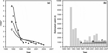
Some stock assessments also provide evidence for orange roughy using more than just seamount habitat, as the initial spawning biomass could not have provided enough recruits to support the subsequent seamount fishery. For example, a quantitative stock assessment of the Andes seamount complex to the east of New Zealand shows an increasingly poor model fit to the biomass index, and a retrospective pattern where the initial spawning stock biomass and thus expected future catch both increase as the time-series extends (Fig. 1). The most obvious explanation for this is that the area was not a discrete stock (Dunn & Devine Reference Dunn and Devine2010), and the seamount biomass and catches were being augmented by immigration.
Orange roughy (a) alternative stock assessment model fits (lines) to a catch per unit effort biomass index (standardized t per tow indicated by points) from the New Zealand Andes seamount complex, and (b) the accompanying catch history (bars) and estimated average potential future catches (horizontal lines) derived from each model (data from Dunn Reference Dunn2007). Model A is fitted over the first five years, B the first 10 years, and C the full 13 years of data.

Seamounts are not, therefore, expected to support discrete stocks, except perhaps on very large and isolated oceanic seamounts. However, whether there is widespread mixing of fish, and natal fidelity to seamount spawning aggregations, remains equivocal, with studies on orange roughy from the North Atlantic finding significant genetic population differences between seamounts (for example Carlsson et al. Reference Carlsson, Shephard, Coughlan, Trueman, Rogan and Cross2011) as well as little regional variation (for example White et al. Reference White, Steffani, Stamford and Hoelzel2009). Off Australia, orange roughy showed complex spatially structured populations (Thresher & Proctor Reference Thresher and Proctor2007), and off New Zealand greater differences were recorded between fish sampled at different times of year at the same location, than between different locations sampled at the same time of year, suggesting turnover of independent fish schools at the same location (Smith & Benson Reference Smith and Benson1997).
The interaction of habitat and fishery type
Many deep-sea species aggregate on seamounts or ridge peaks, and fisheries have targeted these aggregations. Fishes that aggregate on seamounts are potentially more vulnerable to depletion than those dispersed on shelf or slope habitat, because the seamounts effectively act as fish-aggregating devices, where the fishery can maintain catch rates despite declining stock biomass.
A key characteristic of seamount fisheries is the spatially focused interaction between fish and fisheries. Target trawling on seamounts is often localized, and the density of tows can be high (see O'Driscoll & Clark Reference O'Driscoll and Clark2005). Although spawning aggregations on seamounts may be short-lived, they may nevertheless support substantial fisheries. Spawning aggregations of orange roughy occur on seamounts off Tasmania (Bax et al. Reference Bax, Tilzey, Lyle, Wayte, Kloser, Smith and Shotton2005), New Zealand (see Clark et al. Reference Clark, Anderson, Francis and Tracey2000), Chile (Paya et al. Reference Paya, Montecinos, Ojeda, Cid and Shotton2005), northern Namibia (Branch Reference Branch2001), in Irish waters (Shephard & Rogan Reference Shephard and Rogan2006) and on the south-west Indian Ridge (Jaap & James Reference Japp, James and Shotton2005). Fish aggregations and fisheries also occur on seamounts outside of the spawning season in most regions, with the fish aggregations most likely because seamounts provide improved feeding opportunities (for example Clark et al. Reference Clark, Rowden, Schlacher, Williams, Consalvey, Stocks, Rogers, O'Hara, White, Shank and Hall-Spencer2010a ). Heavy bottom trawl gear is used to tow on the rough and hard bottom characteristic of seamounts, and the invertebrate fauna, often dominated by large, slow-growing, sessile organisms, are especially vulnerable to damage by fishing gear (see Clark & Koslow Reference Clark, Koslow, Pitcher, Morato, Hart, Clark, Haggan and Santos2007). Fishing grounds often occur offshore, and so are carried out by large powerful vessels with the ability to work large gear, catch and process large amounts of fish, and stay at sea for long periods. With improved navigation and electronic equipment, vessels can now accurately locate and map seamounts, and locate fish aggregations.
The market value of some of the deep-sea fishes is high, which creates an incentive for commercial operators to target them (Japp & Wilkinson Reference Japp and Wilkinson2007). Nevertheless, the cost of operating large vessels offshore is also high, and some fisheries would not have developed without substantial subsidies (Sumaila et al. Reference Sumaila, Khan, The, Watson, Tyedmers and Pauly2010). The densities of many seamount aggregating fishes are substantially lower on the slope, to the extent that a fishery on the same species on the slope would rarely be economical. The sequential fishing of seamounts for orange roughy is an indication that vessels often need to keep moving to maintain catch rates (see Clark et al. Reference Clark, Anderson, Francis and Tracey2000). If seamounts were closed to conserve biodiversity (see below), effort might be displaced to the slope, where the lower catch rates could lead to the economic collapse of the fishery.
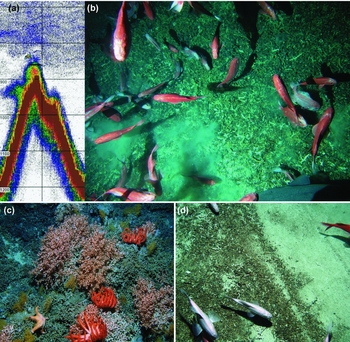
On the north-west Chatham Rise, east of New Zealand, orange roughy aggregations on the ‘Graveyard’ seamount complex have been fished since the early 1990s. The stock was estimated to be depleted in 2006, and the fishery increasingly focused on spawning aggregations to maintain good catch rates (Anderson & Dunn Reference Anderson and Dunn2008). The main aggregation used to be on the ‘Graveyard’ hill but, by the mid-2000s, the aggregations were relatively small and intermittent, and the neighboring ‘Morgue’ hill, closed to fishing in 2001, appeared to support a substantial spawning aggregation (Fig. 2; Smith et al. Reference Smith, Hart, McMillan and Macaulay2008). Given relatively low catch rates (and hence poor economics), the fishing industry instigated a voluntary closure of the stock in 2011 to allow it to recover. Had Morgue been open, the aggregation would undoubtedly have been fished, and might have maintained the fishery. Whilst the closure of Morgue and other seamounts did not ensure a sustainable orange roughy fishery (the closures were never intended to, they were to protect biodiversity), it nevertheless provided some orange roughy with a last refuge.
Seamount habitat and fisheries on the ‘Graveyard’ seamount complex. (a) Echogram of ‘Morgue Seamount’, showing orange roughy at and near the summit (the orange and green blob-like shapes above the sea floor, which is indicated by the strong dark red line). (b) Orange roughy aggregation photographed near the summit (top right panel). (c) Unfished coral habitat, with associated seastars. (d) Trawling impact showing coral rubble on the seafloor and a large gouge caused by a trawl door. Images (a), (c) and (d) courtesy of National Institute of Water and Atmospheric Research (NIWA), image (b) courtesy of NIWA-Ministry of Fisheries.

Research and management difficulties
The basic data requirements for deep-sea seamount species are no different from any other stock: knowledge of the catch, the production potential, and the ability to measure and monitor the stock biomass (Francis & Clark Reference Francis and Clark2005; Dunn et al. Reference Dunn, Ardron, Gianni and Menezes2011). A distinct problem for seamount populations is the very rapid depletion that is possible given the aggregation behaviour of the fish, and thereby a need for effective monitoring and rapid stock assessment (Haedrich et al. Reference Haedrich, Merrett and O'Dea2001; Francis & Clark Reference Francis and Clark2005). However, assessment of orange roughy stocks has proven to be difficult and time-consuming, and the assessments, where they have been completed, can be especially uncertain (Punt Reference Punt and Shotton2005; Sissenwine & Mace Reference Sissenwine and Mace2007). The uncertainty in the science has at times led to subsequent management responses being too slow or insufficient (see Boyer et al. Reference Boyer, Kirchner, McAllister, Staby and Staalesen2001; Bax et al. Reference Bax, Tilzey, Lyle, Wayte, Kloser, Smith and Shotton2005).
High uncertainty in scientific advice, and quantitative stock assessments in particular, has probably more readily allowed fishery managers to favour inaction rather than to heed advice from scientists (Walters & Martell Reference Walters and Martell2004). In our opinion, broad statements and qualitative advice from scientists, such as ‘deep sea fishes are highly vulnerable’ (Francis & Clark Reference Francis and Clark2005) or ‘fishery management should be highly precautionary’ (Stone et al. Reference Stone, Madin, Stocks, Hovermale, Hoagland, Schumacher, Etnoyer, Sotka, Tausig, Glover and Earle2004), have usually proven to be insufficient to persuade managers to reduce catches given the criticism catch reductions bring from fishers because of short-term lost revenue. In New Zealand, a court ruled that such qualitative precautionary scientific advice was actually insufficient for use in orange roughy fishery management (see URL http://www.beehive.govt.nz/release/response-antons-court-case-ruling). Precautionary management is clearly required for deep sea fisheries, but the standard target reference points and management concepts (such as maximum sustainable yield and fishing down practices) applied in several deep-sea fishing countries have proven risky and over-optimistic (Sissenwine & Mace Reference Sissenwine and Mace2007). Establishing sufficiently conservative management rules with accompanying credible scientific monitoring and advice remains a key challenge (Dunn et al. Reference Dunn, Ardron, Gianni and Menezes2011).
What is needed for fisheries sustainability?
There are increasing data, reporting requirements and appropriate potential management actions to help sustain deep-sea fisheries (see Francis & Clark Reference Francis and Clark2005; FAO 2009; Sissenwine & Mace Reference Sissenwine and Mace2007; Dunn et al. Reference Dunn, Ardron, Gianni and Menezes2011). It is unknown whether any new deep-sea fisheries may be developed in the future, but it is clear that more precautionary management is the key element that must limit expectations and fishing mortality in the development, and recovery, of any deep-sea or seamount fishery.
Spatial catch limits are an obvious way to restrict exploitation, but these must be precautionary and enforced. Fishing mortality needs to be controlled from the outset, and fishery development limited until the size and dynamics of the stocks are sufficiently known. This can be difficult, as in Namibia, where such an approach did not result in a sustainable orange roughy fishery (Boyer et al. Reference Boyer, Kirchner, McAllister, Staby and Staalesen2001). Inadequate compliance with restrictive quotas can also increase the rate of stock decline well beyond the intended management target, examples being the overfishing of orange roughy off Australia (Bax et al. Reference Bax, Tilzey, Lyle, Wayte, Kloser, Smith and Shotton2005) and Ireland (Shephard et al. Reference Shephard, Connolly, Hareide and Rogan2007b ). Setting precautionary catch limits will be difficult for many fisheries because of the difficulties in completing credible ‘standard’ quantitative stock assessments (such as population models fitted to observational data). A better approach could be to set the catch limit to some proportion of the current observed biomass (Dunn et al. Reference Dunn, Ardron, Gianni and Menezes2011). A robust catch limit might be identified using management strategy evaluation (MSE) simulations (see Butterworth & Punt Reference Butterworth and Punt1999).
In many cases, catch limits are imposed over relatively large areas, within which the number and distribution of populations is poorly known (for example ICES [International Council for Exploration of the Sea] 2011). Hence catch limits may not protect individual populations from being overfished. In the absence of sufficient information on stock structure to define appropriate spatial boundaries, a potential solution is to impose catch limits for individual features, thereby guarding against local or serial depletion. In two regions off New Zealand, feature catch limits have been imposed (New Zealand Ministry of Fisheries 2010). In one, the catch within a 10 nautical mile radius of the fished feature (a seamount or ridge peak) is restricted to 100 t yr−1. Once that limit is reached, the vessel must move on. In another area, a 500 t annual limit was imposed within a defined ‘box’ around an area of initial large catches. Here the catch rates within the box declined rapidly and the fishery effectively collapsed (data in New Zealand Ministry of Fisheries 2010). Seamount catch data indicate that initial orange roughy biomass on a single seamount may only be a few thousand tonnes (Clark et al. Reference Clark, Bull and Tracey2001, Reference Clark, Dunn and Anderson2010b ) implying that long-term yield is only a few hundred tonnes. An arbitrary limit as high as 500 t for a species like orange roughy is not precautionary. Although fine-scale spatial management may be desirable, the restrictions on fishing practice and the additional regulations could make it undesirable from both fishers' and fishery managers' perspectives.
Seamount closures or feature catch limits might prevent depletion of aggregations on a single feature, but may not prevent stock depletion if much of the stock is not on seamounts. Closures or limits may actually displace the fishery into other areas, which might include the target species nursery grounds. Whilst closed seamounts can act as a ‘last refuge’, spatial closures designed to protect sufficient fish to ensure sustainable fisheries would have to be more extensive. Spatial closures need clear objectives and careful design, and need to balance the conflicting objectives of protecting a proportion of the stock, yet maintaining the economic viability of the fishery. Several countries have closed substantial deep-sea regions of their exclusive economic zone to bottom trawling, but these may not necessarily benefit fish stocks; the c. 1.1 million km2 of seabed protected from trawling around New Zealand (Helson et al. Reference Helson, Leslie, Clement, Wells and Wood2010) includes very little of the main target species’ distributions.
Continuous fishery monitoring and reactive scientific research are necessary to collect the time-series of data required for most stock assessment approaches, and to allow prompt quantitative scientific advice. Stock assessment research should be secondary to effective precautionary catch limits however, because research takes time, yet the fishers can develop fisheries and deplete stocks very quickly. However, in many cases to date, scientific advice has not been successful in preventing stocks being overfished. Deep-sea fisheries would be best restricted to those where effective fishery monitoring takes place, where existing scientific stock assessment methods can be confidently and quickly applied, and where precautionary and responsive fishery management can be implemented and enforced.
CONSERVATION OF DEEP-SEA SEAMOUNT HABITAT
Seamounts have several ecological characteristics that distinguish them from slope and abyssal habitat. They provide a range of depths for different communities, often have bare rock surfaces on the summit and flanks, and the physical structure of some seamounts enables the formation of hydrographic features and current flows that can keep species and production processes concentrated over the seamount rather than dispersing into the wider ocean system. These conditions mean that seamount invertebrates can be diverse and abundant (Clark et al. Reference Clark, Rowden, Schlacher, Williams, Consalvey, Stocks, Rogers, O'Hara, White, Shank and Hall-Spencer2010a ; Schlacher et al. Reference Schlacher, Rowden, Dower and Consalvey2010). Benthic communities are often dominated by concentrations of suspension feeders, such as large corals and sponges, which can form extensive and complex reef-like structures (Fig. 2) and in turn provide a habitat for smaller mobile fauna. Fish communities on seamounts can also be diverse and some species can be abundant (see Morato & Clark Reference Morato, Clark, Pitcher, Morato, Hart, Clark, Haggan and Santos2007), such that commercial catches on seamounts are often very ‘clean’, comprising few species, and fisheries by-catch levels are typically higher when trawling on more dispersed communities on the continental slope (Anderson Reference Anderson2011). Conservation of seamount communities often focuses on invertebrates, but fish diversity also needs to be considered.
While the role of seamount habitat for benthic invertebrate communities is clear, the extent of direct dependence of fish upon the seamount is uncertain. Many large fish species are associated with seamount habitat (see for example Morato & Clark Reference Morato, Clark, Pitcher, Morato, Hart, Clark, Haggan and Santos2007) and seen on or near to cold-water coral reef structures (see Costello et al. Reference Costello, McCrea, Freiwald, Lundalv, Jonsson, Bett, van Weering, de Haas, Roberts, Allen, Freiwald and Roberts2005; Auster Reference Auster, George and Cairns2007), but direct use has seldom been examined (but see Soffker et al. Reference Soffker, Sloman and Hall-Spencer2011). Adult orange roughy on a number of New Zealand seamounts continue to return to spawn even after the benthic habitat is effectively degraded. However, small-bodied species or early life history stages could use seamounts as nursery grounds or for protection amongst corals or rough seafloor (for example see Husebo et al. Reference Husebo, Nottestad, Fossa, Furevik and Jorgensen2002; D'Onghia et al. Reference D'Onghia, Maiorano, Sion, Giove, Capezzuto, Carlucci and Tursi2010).
Bottom trawling impacts
Benthic communities of seamounts, like most deep-sea biota, can be severely impacted by bottom trawling, at the scale of individual seamounts, including destruction and removal of extensive areas of the stony coral matrix that forms complex biogenic habitat on the summits and upper flanks of seamounts (Koslow et al. Reference Koslow, Gowlett-Holmes, Lowry, O'Hara, Poore and Williams2001; Clark & Rowden Reference Clark and Rowden2009) (Fig. 2). Stony corals can dominate the biomass of seamount megafauna on seamounts and ridge structures (Rowden et al. Reference Rowden, Schlacher, Williams, Clark, Stewart, Althaus, Bowden, Consalvey, Robinson and Dowdney2010b ); these corals and other seamount megafauna can be extremely long-lived (Rogers et al. Reference Rogers, Baco, Griffiths, Hart, Hall-Spencer, Pitcher, Morato, Hart, Clark, Haggan and Santos2007), and their recovery from damage is likely to be very slow. Despite being closed to bottom trawling for 5–10 years, the fauna of seamounts off Australia and New Zealand showed no evidence of recovery to an unfished state (Williams et al. Reference Williams, Schlacher, Rowden, Althaus, Clark, Bowden, Stewart, Bax, Consalvey and Kloser2010). Closing seamounts after fishing is therefore an ineffective method for conserving seamount communities; benthos must be protected from bottom trawling before it occurs.
Reducing bottom trawl impact
The issue of reducing the impact of fishing gear, especially bottom trawling, is not specific to seamounts as it is a major concern in most habitats. Various technical modifications can reduce fisheries by-catch, but reducing the impact on benthic animals, sessile invertebrates in particular, is more difficult. Lightening the ground rope, reducing trawl door weight and shortening the sweep wires that lead from the doors to the net can help, but are unlikely to substantially reduce the damage to the benthos, because the invertebrates are so fragile. Use of midwater gear close to the bottom of the sea or long-line fishing may be feasible. The likely application of such methods will vary with target species and seamount, and operationally will almost certainly involve a trade-off between bottom impact and catch rate of fish species.
What is needed for effective habitat conservation?
The use of bottom trawls in many seamount fisheries cannot be avoided. Various management actions taken to date include closed seamounts, fishing method or gear restrictions, depth limits, individual seamount catch quotas, by-catch quotas and habitat exclusion areas (see Probert et al. Reference Probert, Christiansen, Gjerde, Gubbay, Santos, Pitcher, Morato, Hart, Clark, Haggan and Santos2007; Morato et al. Reference Morato, Pitcher, Clark, Menezes, Tempera, Porteiro, Giacomello and Santos2010). Move-on rules have recently become a common management tool, promoted by United Nations General Assembly resolutions for high seas fisheries, which force vessels to move a certain distance if a threshold catch of vulnerable marine ecosystem (VME) species is exceeded (Rogers & Gianni Reference Rogers and Gianni2010; Auster et al. Reference Auster, Gjerde, Heupel, Watling, Grehan and Rogers2011). However, in a standard deep-sea trawl, ground gear impacts will affect the sea bed over a distance of 20–30 m width, while the sweeping wires between the trawl doors can affect a width of 150 m. The cumulative area swept by bottom trawl fisheries is typically the most extensive human impact on the seafloor (Benn et al. Reference Benn, Weaver, Billet, van den Hove, Murdock, Doneghan and Le Bas2010; Ramirez-Llodra et al. Reference Ramirez-Llodra, Tyler, Baker, Bergstad, Clark, Escobar, Levin, Menot, Rowden, Smith and Van Dover2011). Even a single trawl can cause considerable damage, and there are further issues with move-on rules, such as threshold criteria and forcing fishing effort to spread further (Auster et al. Reference Auster, Gjerde, Heupel, Watling, Grehan and Rogers2011). Benthic habitat needs protection measures in place before fishing occurs.
The identification of where fishing has already occurred is often lacking in deep-sea fisheries (Clark et al. Reference Clark, Schlacher, Rowden, Stocks and Consalvey2012), although such data are valuable for the design of conservation areas. Vessel location from satellite data identifying areas of potential fishing impact, combined with knowledge of coral distribution, were used to design marine protected areas (MPAs) west of the UK (Hall-Spencer et al. Reference Hall-Spencer, Tasker, Soffker, Christiansen, Rogers, Campbell and Hoydal2009).
Several issues need to be considered for effective management of activities affecting biodiversity on seamounts, and management objectives need to incorporate natural variability over time, work across governance boundaries, be highly precautionary, and target recovery, restoration and prevention (Probert et al. Reference Probert, Christiansen, Gjerde, Gubbay, Santos, Pitcher, Morato, Hart, Clark, Haggan and Santos2007). A variety of management tools exist that could be applied to protect seamounts, but the most effective are almost certainly area closures, where destructive activities are strictly prohibited on or near seamounts (see Johnston & Santillo Reference Johnston and Santillo2004; Clark & Koslow Reference Clark, Koslow, Pitcher, Morato, Hart, Clark, Haggan and Santos2007). The concept and components of marine spatial planning as an integral aspect of resource management are now well established and guidelines to aid its effectiveness have been developed (Ehler & Douvere Reference Ehler and Douvere2009; Foley et al. Reference Foley, Halpern, Micheli, Armsby, Caldwell, Crain, Prahler, Rohr, Sivas, Beck, Carr, Crowder, Duffy, Hacker, McLeod, Palumbi, Peterson, Regan, Ruckelshaus, Sandifer and Steneck2010). However, the type of systematic conservation planning that is associated with ecosystem-based management, such as the development of networks of MPAs (for example see PISCO [Partnership for Interdisciplinary Studies of Coastal Oceans] 2007) is much more difficult to implement in the deep-sea than in coastal waters or on land. In part, the problems have historically been less obvious because most of the fisheries are well offshore and out of sight, governance of high seas areas is limited, and research is fundamentally more difficult in deep water (Koslow Reference Koslow2007). Nevertheless, deep-sea science has increased considerably in recent years, and the need for management of increasing human pressure and a ‘precautionary approach’ (FAO 2009) is now well recognized (see Glover & Smith Reference Glover and Smith2003; Davies et al. Reference Davies, Roberts and Hall-Spencer2007). There is, however, progress in the four stage sequence of conservation planning (Committee on the Evaluation, Design, and Monitoring of Marine Reserves and Protected Areas in the United States 2001): (1) evaluation of conservation needs, (2) definition of management objectives, (3) integration of ecosystem information, and (4) selection of conservation sites. Current emphasis is on steps 3 and 4, and adoption of the concept of spatial networks to protect habitat and enhance fisheries (see Johnston & Santillo Reference Johnston and Santillo2004).
Several characteristics of seamounts need to be considered when developing spatial planning options. Seamount communities can vary considerably between adjacent seamounts, with differing depth profiles, shapes, sizes and substrate types. Hence a number of features will need to be protected in order to conserve representative biodiversity. This requires a network of protected areas, whereby bottom-contact fishing is prohibited.
Sector management, where part of a seamount is protected, may seem an acceptable option, but the spatial scale of the functioning of seamount communities is unknown. Faunal composition can vary among depths and locations on seamounts, and so it is hard, if not impossible, to determine which sectors should be closed or open. The practical operation of bottom trawling means the gear needs to be landed on the summit of seamounts, where corals and sponges can be most abundant, to stabilize before towing down the flanks. It can also be very hard to control the location of trawl gear at 1000 m depth; there may be 2000 m of wire out between the vessel and the net. Compliance would also be a problem at such a fine spatial scale of management. The only feasible solution is to protect the entire seamount.
The size of any MPA, or the distance between neighbouring MPAs, is a central element to the design of MPA or closed area networks. Because seamounts are the main source of shallower habitats in oceans, where the seafloor is primarily at abyssal depths, faunal assemblages that occur at shallower depths than the deep sea floor need to find and colonize seamounts, island slopes or ridge peaks/highs. The dispersal capabilities of benthic invertebrates are largely unknown, but several papers have reviewed existing knowledge. Most shallow-water invertebrate taxa are able to disperse over distances < 100 km (Kinlan & Gaines Reference Kinlan and Gaines2003) and, for seamounts, genetic evidence indicates octocoral dispersal over distances of 100–200 km along the Hawaiian seamount chain (Baco & Shank Reference Baco, Shank, Freiwald and Roberts2005), bamboo corals show no genetic separation over large-scale ocean basins (Smith et al. Reference Smith, McVeagh, Mingoia and France2004) and some taxa with non-plankotrophic larvae show separation on smaller scales (Samedi et al. Reference Samedi, Bottan, Macpherson, Richer de Forges and Boisselier2006). Whilst a separation distance of > 100 km has been used to indicate an ‘isolated seamount’ (Clark et al. Reference Clark, Watling, Rowden, Guinotte and Smith2011), this distance may not actually mean isolation for many taxa (especially fish), but is more conservative for conservation purposes than defining too large a distance. Multiple seamounts may need to be protected, especially clusters of small volcanic peaks, which are unlikely to be independent.
INTEGRATED FISHERIES AND HABITAT SPATIAL MANAGEMENT
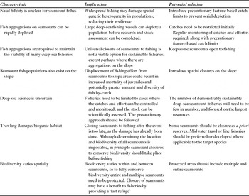
Potentially conflicting solutions underpin the spatial management options for fisheries and habitat management (Table 1). The sustainability of existing fisheries would be enhanced by restricting them to cases where credible and timely science can be completed, and where catches and fishing effort can be monitored and controlled. This would include setting truly precautionary catch limits and targets, whilst avoiding displacement of fishing effort onto slope areas.
Characteristics of seamount fisheries, and the implications and potential solutions to mitigate those characteristics.

Developing deep-sea seamount fisheries would be better sustained by initially limiting catches to small quantities until the true size of the resource could be estimated. Given that no more than a few thousand tonnes of fish might be present on a seamount, a truly precautionary catch limit would have to be low. For example, assuming 1000 t on a seamount as an a priori default, and a catch limit calculated by setting the annual fishing mortality equal to natural mortality (c. 4.5% for orange roughy) multiplied by the current biomass (a method used by the New Zealand Ministry of Fisheries 2010), would result in an annual limit of just 45 t. Low and precautionary initial feature-based catch limits would allow exploration for new resources and, if credible scientific evaluation and monitoring of the resource was required in order to justify a higher catch limit, long-term commercial fisheries would then be restricted to those few seamounts where large and measurable fish aggregations occurred. Given the poor sustainability history of most deep-sea fisheries, focusing resources on the largest stocks may be the only way to achieve demonstrably sustainable deep-sea fisheries (Dunn et al. Reference Dunn, Ardron, Gianni and Menezes2011; Norse et al. Reference Norse, Brooke, Cheung, Clark, Clark, Ekeland, Froese, Gjerde, Haedrich, Heppell, Morato, Morgan, Pauly, Sumaila and Watson2011).
However, this gives environmental managers a difficult trade-off between fisheries and biodiversity conservation. Do they restrict fishing to a small number of seamounts and accept potentially severe habitat impact on those seamounts, or force fishing effort to cover more seamounts, hopefully reducing individual seamount impacts. We suggest the most acceptable solution, for both existing and developing fisheries, is to protect some seamount areas completely, allowing undisturbed ecosystems to exist with no human impact on structure or function. This assumes some benthic communities will be heavily impacted, perhaps even destroyed, by fishing activity, effectively analogous to allowing farming on land to destroy some forest and replace it with pasture, while at the same time ensuring that representative habitats are preserved in national parks or reserves.
There are many seamounts that are now protected in some form around the world (see Morato et al. Reference Morato, Pitcher, Clark, Menezes, Tempera, Porteiro, Giacomello and Santos2010). There are approximately 500 large seamounts and 500 smaller knolls within areas listed by the World Database of Protected Areas, but this is still a very small proportion (1.5% and 0.7%, respectively) of the estimated global numbers of these features (Yesson et al. Reference Yesson, Clark, Taylor and Rogers2011). Many of these appear to have been protected without considering network design principles or attempting to represent a wide range of seamount habitat. Even without much hard biological data on seamount communities, it is possible to use habitat suitability models to predict the likelihood of seamounts hosting particular taxa (Davies & Guinotte Reference Davies and Guinotte2011), derive risk indices to rank the threat of fishing (Clark & Tittensor Reference Clark and Tittensor2010) and use biophysical variables as surrogates for biological assemblages (Anderson et al. Reference Anderson, Nichol, Syms, Przeslawski and Harris2011) to classify seamounts on regional or global scales (Rowden et al. Reference Rowden, Clark and Wright2005; Clark et al. Reference Clark, Watling, Rowden, Guinotte and Smith2011). A lack of robust data should not be an excuse for inaction, and there are sufficient indications that a combination of open and closed seamounts (with associated research and enforcement) should be an effective management strategy to balance fishing with habitat protection.
ACKNOWLEDGEMENTS
This paper represents viewpoints developed over many years of researching both deep-sea fish stocks and seamount ecosystems. We acknowledge thoughtful discussions with many colleagues over the years. Support for writing the paper was provided by the Census of Marine Life on Seamounts (‘CenSeam’) and the New Zealand Ministry of Science Innovation project on vulnerable deep-sea communities (contract CO1X0906).