1. A history of fieldwork at Jerwan
The limestone aqueduct of Jerwan, in the plain of Navkur (Dohuk region) of present-day Iraqi Kurdistan, is undoubtedly one of the most imposing monuments erected by the Assyrian king Sennacherib, as may still be judged today.Footnote 2 This vast monument was the object of a four-week campaign of archaeological survey (with light digging activities) in March–April 1933 by the British archaeologist Seton Lloyd and the Danish-American Assyriologist Thorkild Jacobsen, as a collateral activity to the imposing excavation (1928–35) that the Oriental Institute of Chicago was undertaking in nearby Khorsabad, ancient Dur-Šarrukin.Footnote 3 This brief but intense effort by the two specialists—both at the outset of their careers, and destined to great fame in their respective fields—yielded within a short span of time a well-known monograph, with detailed descriptions and a rich apparatus of plans and photographs of the aqueduct and of the cuneiform texts therein discovered.Footnote 4
The Jerwan monument was first observed and briefly described by Austen Henry Layard, although he misunderstood its nature and purpose: “The remains of a well-built causeway of stone, leading to Bavian from the city of Nineveh, may still be traced across the plain to the east of the Jebel Makloub”.Footnote 5 The British Assyriologist Leonard W. King was the next notable visitor, half a century later (1904); his photographic impressions of the monument were given over to his German colleague Eduard Meyer.Footnote 6 The American historian Albert Ten Eyck Olmstead visited the site in 1908.Footnote 7
The hydraulic nature of the monument was first recognized by Walter Bachmann during a vast survey campaign of northern Assyrian rock reliefs conducted on behalf of the Deutsche Orient-Gesellschaft in 1914. In the 1927 publication of his findings, however, the German architect offered an interpretation of the artefact as the remains of a stone dam: “Das Bauwerk stellt sich dar als Rest eines ausgedehnten steinernen Dammes… Der Damm bildete so eine künstliche Talsperre, die dazu diente, größere Wassermengen zur Bewässerung der anschließende Ebene aufzuspeichern”.Footnote 8 It was also described by E.A. Speiser, who visited the area on behalf of the Baghdad branch of the ASOR in the very same year, as a “large dam near the village of Jerwana”, where “some of the inscribed blocks… showed it to be the work of Sennacherib.”Footnote 9 Speiser's observations led directly to the decision of Jacobsen and Lloyd to investigate the monument some five years later.
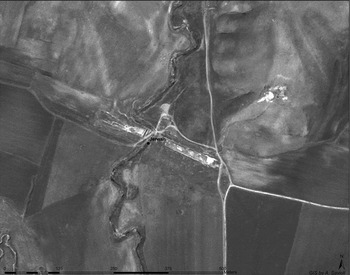
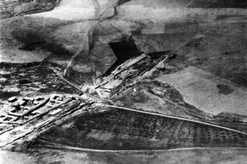
No subsequent investigations of the monument were attempted, due in part to local conditions of conflict and political unrest until very recent times. In early 2012 the Jerwan aqueduct formed the object of a preliminary, archaeological-territorial, low-intensity survey on the part of the MAIA expedition,Footnote 10 accompanied by a cartographical analysis and a study of the satellite imagery (Fig. 1).Footnote 11 In the late summer of the same year, the two authors—entrusted with the epigraphical aspects of the expedition—undertook a detailed evaluation of the inscriptions on the monument.Footnote 12 The present article describes the results of their investigation on the cuneiform texts from Jerwan, considered per se and in the context of the architecture of the aqueduct, to the aim of effecting a comparison with Jacobsen's and Lloyd's findings and of offering new results and hypotheses on specific issues.
The aqueduct of Jerwan: OrbView satellite photograph, elaborated by A. Savioli (©MAIA)

2. The present condition of the aqueduct
Nowadays, the Jerwan aqueduct may be reached by a short stretch of dirt road which leads northward from the highway linking Dohuk and Erbil, opposite the village of Mahad. Save for a small one-story building at the eastern edge bearing a sign of the Directorate of Antiquities of Dohuk, and for a low stone wall topped by a wire fence which runs at a short distance on the southern side for some 300 metres, nothing else denotes the nature of the place as an archaeological area—which evidently enjoys a “light” guard on the part of the inhabitants of the village located a few kilometres to the southeast, who pass by with flocks or in small trucks. On the other hand, perhaps exactly due to lack of publicity, visitors to the site are scarce.Footnote 13
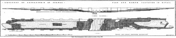
At all events, the general appearance of the monument, with its two halves clearly marked out on both sides (E and W) of the wadi which the aqueduct crossed over four corbelled vaults,Footnote 14 is nowadays much more legible than it must have seemed to Jacobsen and Lloyd upon their first visit in April 1932. The two scholars, who had arrived from Khorsabad on country lanes, found themselves facing “a low wall of stone so completely covered with grass that it was only recognizable as such in a few places where the stones projected above the turf”.Footnote 15 In contrast, at the end of their work the following year, cleaning and digging had brought to light the good state of preservation of various parts of the monument, which they measured at 280 metres in length by 22 metres in width, while the maximum height on the surrounding countryside (near the archway crossing the wadi) is 9 metres (Fig. 2).Footnote 16
Plan and elevation of the Jerwan aqueduct. Reprinted from Jacobsen and Lloyd Reference Jacobsen and Lloyd1935 Fig. 2, courtesy of the Oriental Institute of the University of Chicago

On the basis of these measurements, Jacobsen and Lloyd further estimated that more than two million blocks of a standard measure of fifty cubic centimetres had been employed for building, although they gave no indication as to how they had reached this result. Perhaps it was mere guesswork, because by attempting a theoretical calculation it may be shown that they were widely off the mark. The calculation may be explained thus: if one proceeds from the hypothesis that the structure was a rectangular parallelepiped,Footnote 17 the overall volume of the monument in cubic metres may be obtained by multiplying the basic area by the height: (280 m × 22 m) × 9 m = 55,440 m3. To build one cubic metre of the structure, eight blocks of fifty cubic centimetres were required. Thus to gauge the number of blocks used to build the entire structure we must multiply its volume by eight: 55,440 × 8 = 443,520 blocks. As may be seen, only about one-fifth of Jacobsen's and Lloyd's figure is attained, although the quantity of stone material theoretically required/employed remains utterly remarkable, and as such deserves further consideration as to its possible origin (cf. §6, below).
According to Jacobsen and Lloyd, each block should have weighed some 250 kg.Footnote 18 It is of course impossible to estimate the construction work involved, in terms of time and manpower, although it is probable that various teams were at work simultaneously, following a method well attested in contemporaneous written evidence.Footnote 19 Thus, for example, on the NE facade, secondary adjustments and ad hoc parings of the blocks seem to have been performed in those points where the work of different squads joined up, with the consequence of small misalignments. Also consistent groups of limestone flakes, retrieved near the base of the structure, should testify that the outer face of the blocks had been worked on in situ. The masons appear to have pared down the blocks only along the outer bands of conjunction with the adjoining ones, while leaving an abutting central zone in a more or less unworked state—an effect which gives the impression of an intentional rustication of the blocks.Footnote 20
The top surface of the structure, over which the canal water flowed, may be observed in both the E and W halves as made only of a few courses of stone pavement over a bed of limestone concrete some 40 cm thick (presumably to prevent percolation), flanked by the canal parapet (Fig. 3). The original height of the latter may only be guessed at, since all that remains is a course of blocks at the north-eastern tip; this is sufficient to gauge its width of approx. 1.60 metres.Footnote 21 The stone pavement is despoiled; the excavators suggested that a possible function for it was to aid the progressive transport of the blocks of the structure itself during construction,Footnote 22 but this remains open to further study.
(a) View of the surface of the aqueduct from E. In the foreground, remains of the stone paving; behind, the underlying layer of cement. To the right, remains of the parapet; (b) view from SE (photo ©MAIA)

The remainder of the vast monument lay exposed after its abandonment to wind and rain, and presumably also to the repeated efforts of those hunting for usable building materials. Already in 1933 notice had been taken of major despoilment of the central part of the aqueduct, nowadays largely missing, and of the NW facade, where numerous blocks prove to have been pried loose. Here the wadi waters at their highest could have exerted a particular pressure on the structure, judging from the fact that, in correspondence with the NW face, they briefly flow in parallel to the masonry and quite close to it, before curving abruptly southwards to pass under the arches.Footnote 23 It is thus possible that through the centuries the watercourse may have slowly eroded the ground near the aqueduct, weakening its foundations and favouring collapses and subsidence of the structure itself.Footnote 24
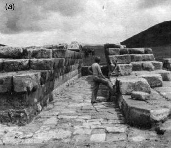
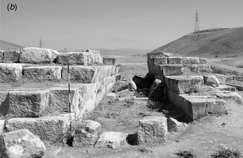
In a more positive vein, it must be pointed out that the monument is still visible and to be savoured in its entirety, from West to East, all the more so after the reclaiming of the area as an element of cultural heritage on the part of the Directorate of Antiquities of Dohuk.Footnote 25 Its state moreover still corresponds by and large to the one left by Jacobsen and Lloyd at the close of their investigation, save for the collapse of a number of blocks on the highest reaches of the structure (and for some disappearances, probably due to despoilment), as well as for partial landfills—due to the lack of regular maintenance—in the lower rows of stone blocks, where cleaning and light digging had taken place.Footnote 26 All these effects may be observed, for example, at a glance in a comparison of photographs of the westernmost archway taken some 80 years apart (Figs. 4, a–b).
The remains of the westernmost archway, view from S, in 1933, with Lloyd (l.) and Jacobsen (seated). Reprinted from Jacobsen and Lloyd Reference Jacobsen and Lloyd1935, pl. VIII B, courtesy of the Oriental Institute of the University of Chicago

The remains of the westernmost archway, view from S, nowadays (photo ©MAIA)

***
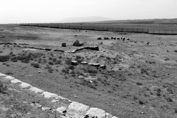
In fact, the difference between the present state of the monument and that of the 1930s lies not so much in its archaeological visibility as in the sphere of human settlement. Jacobsen and Lloyd found the entire SE sector of the aqueduct tightly flanked by a small hamlet, formed by some twenty mud-brick houses, inhabited by a Yezidi community (Fig. 5).Footnote 27 These houses had foundations and parts of the walls made of blocks coming from the monument itself, some of which must have been inscribed. Eloquent testimony to this practice is provided by the photograph of mayor (mukhtar) ʽAli seated on a square block in front of the entrance to his house, with other blocks bearing cuneiform script in full sight beside him.Footnote 28 The Yezidi village hugging the aqueduct is still visible in an aerial photograph of 1955, and would seem to have grown in size. Nowadays, following intervention by the Kurdish archaeological authorities, the village has been evacuated and razed to the ground, leaving an unrestricted view from the top of the aqueduct to the low wall topped by a wire fence to the South, which closes off the archaeological area. The ground previously occupied by the village is, however, largely devoid of stone blocks, which might have been removed during evacuation (Fig. 6).Footnote 29
The Jerwan aqueduct: air view, with the Yezidi village at bottom left. Reprinted from Jacobsen and Lloyd Reference Jacobsen and Lloyd1935, frontispiece, courtesy of the Oriental Institute of the University of Chicago

Area of the former Yezidi village, as seen from the SE wall; the Jebel Maqlub in the background

Any future program to preserve and reconsolidate the monument must confront a number of problems. First, a persistent, serious threat to the structure is posed by atmospheric agents—specifically winter freezing—and by roots, sometimes developed to the size of those of shrubs, which grow in the gaps between blocks and in the cracks created by weathering. These menaces have created serious damage to many blocks, fracturing them or wearing the corners and the exposed surfaces. A further problem is the growth of organic matter due to water and humidity, which is particularly visible on the north-eastern facade of the aqueduct; here, exposure to the north, with the ensuing lack of direct sunlight, has favoured the formation of moss and lichens on the surface of the limestone blocks, thus making the direct reading of the various copies of inscription B on this facade more arduous.
In summary, the Jerwan aqueduct, while still in an acceptable condition of overall preservation, is on the other hand open to a set of daily and/or seasonal menaces of no small import, and requires a comprehensive and wide-ranging program of action for its preservation and restoration. This program is among the priority aims of the Italian “Land of Nineveh” Regional Archaeological Project, and it is to be hoped that it may be implemented in full and at the earliest possible convenience, with the cooperation of the archaeological authorities of the Kurdistan Regional Government, for the safeguarding of a monument of worldwide significance in the history of technology.
3. The four inscription types
The cuneiform texts preserved on the Jerwan aqueduct are of particular interest for the evaluation of the building history of the monument. Here they will be examined with regard to their presence and location, state of preservation and legibility, and overall possible function, in the light of the on-site reappraisal by the authors in 2012, which also led to a few new findings.
In his editio princeps,Footnote 30 Thorkild Jacobsen distinguished four different types of cuneiform epigraphs incised on the blocks of the Jerwan aqueduct, calling them A–D. All four types are Assyrian royal inscriptions from the reign of Sennacherib. Nonetheless, a crucial distinction should be drawn: whereas types A–C correspond to (fully preserved or restorable) inscriptions of typical Assyrian commemorative/celebrative character with reference to building activities—and specifically types B and C refer to the aqueduct of Jerwan itself—, type D is formed by a vast series of inscribed blocks organized in non-continuous textual sequences, and in fact in a totally random order. As noted below (§5), the contextual link of type D with the Jerwan monument is not apparent to the visitor, however knowledgeable, and in fact leads to more than one hypothesis for its interpretation.
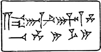
We start with inscription A, which may be found here and there on single blocks within the masonry of the structure.Footnote 31 It is of the textual type known as “label”, and comprises only two lines:
Inscription A:

The first sign, KUR, left Jacobsen puzzled. In an extended comment, he pointed out (following F. Delitzsch) that KUR was known in initial position on bricks from Nineveh, and elsewhere in alternation with É.GAL = ekallu, “palace”. However, he ruled this solution out: “in our case, in an inscription on an aqueduct, the meaning ‘palace’ is obviously not to be considered”.Footnote 32 Jacobsen then raised and dismissed other possible readings of KUR here: šadû, “stone, mountain”; mātu, “country”; kišittu, “spoil”. Finally, he chose a syllabic reading šat, understanding it as a genitive particle of feminine form, šāt, “of (PN)”, or “belonging to (PN)”, although he himself had misgivings about this form being “an anachronism in an inscription of Sennacherib”. This assessment proves to have been correct, and in effect the reading šat = šāt has no real foundation.Footnote 33
We may thus go back to Jacobsen's initial suggestion of reading KUR as an abbreviated writing for É.GAL = ekallu; nowadays, examples of this label on bricks and other materials from Nineveh or other provenances are more abundant than in his time.Footnote 34 The inscription may thus be understood—at least prima facie—as indicating a palatial origin for the relevant stones. And since, as already noted by Jacobsen, absolutely no palatial building marks the site of the aqueduct, the possibility that these stones may have been brought from elsewhere should be borne in mind.
In this light, it may be useful to check the location of the blocks inscribed with this text. Jacobsen stated that inscription A “was found on a great number of stone blocks incorporated within the masonry”, but unfortunately he did not give their exact find spots or even their sector of retrieval (western or eastern). The sole published photograph shows an exemplar within an exposed inner row of masonry, not visible in antiquity;Footnote 35 this led Jacobsen to the idea that “the inscription was not intended to be read until the building had fallen into ruin”.Footnote 36
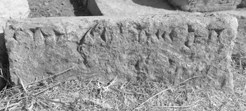
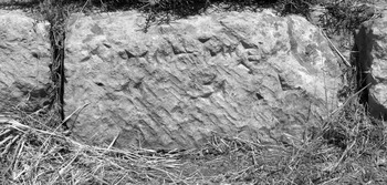
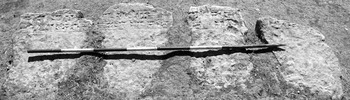
The MAIA expedition retrieved two exemplars of the inscription in 2012.Footnote 37 The first lay at the foot of the SW wall, as part of a wider collapse of the stonework, which was in the main formed by blocks bearing inscription D (Fig. 7). The second was still inserted in an inner row of the masonry of this same sector (Fig. 8); this block, which presents the “short” titulary of the king (i.e. lacking the epithet šar kiššati),Footnote 38 also bears a dense series of diagonal chisel marks, obviously of a later date than the epigraph, possibly to the aim of fitting the stone more comfortably within the relevant facade.Footnote 39
Exemplar of inscription A in the collapse of the SW wall (photo ©MAIA)

Exemplar of inscription A in situ within the SW wall, with chisel-marks (photo ©MAIA)

Summing up, both the older and more recently identified exemplars of inscription A would seem to confirm the idea that the (perhaps numerous) limestone blocks which bore this label referring to a “palace of Sennacherib” could have originated from elsewhere rather than having been engraved in situ for the specific purpose of commemoration/celebration of the aqueduct. It remains an open question whether or not they were intended to be hidden from view, as Jacobsen suggested. In any case, they should have represented components which were originally extraneous to the nature and scope of this hydraulic structure, and which point instead to the re-use of pre-existing architectural material for its construction or consolidation.Footnote 40
Exemplar of inscription A in “mirror-type” writing as copied by Th. Jacobsen. Reprinted from Jacobsen and Lloyd Reference Jacobsen and Lloyd1935, pl. XVII, top right, courtesy of the Oriental Institute of the University of Chicago

***
Inscriptions B and C were explicitly conceived to celebrate the building and the hydraulic functions of the aqueduct. The two types share their basic contents, although they are quite different in form, dimensions, degree of descriptive detail, and overall semiotic characteristics.
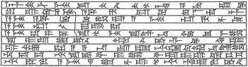
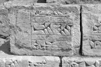
Inscription B was planned to be fully visible to anyone approaching the massive stone structure of the aqueduct: it was incised on a series of five horizontally adjacent blocks, in two vertical rows, and repeated on a number of exemplars on the buttresses and recesses of the well-preserved NE sector of the monument.Footnote 41 From the combination of the various exemplars, a master text of nine lines of writing, accurately executed and well-spaced, with horizontal rulings between one line and the next, was reconstructed by Jacobsen (Figs. 10–11).Footnote 42
Inscription B, status 2012 (photo ©MAIA)

Inscription B, copy by Th. Jacobsen. Reprinted from Jacobsen and Lloyd Reference Jacobsen and Lloyd1935, pl. XVIII, courtesy of the Oriental Institute of the University of Chicago

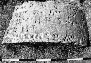
The very same inscription appears to have also decorated a block retrieved on the ground of the NW side of the central area where the arches over the wadi stood. Due to its semi-circular shape, this block was understood by Jacobsen to be a breakwater forming part of the archways themselves. Since the extant text corresponds to about one-half of the one on the NE walls (= lines 1–5), two such blocks must have been placed one above the other. Few traces of wear are visible on Jacobsen's photograph;Footnote 43 thus, it may be surmised that the block was reached only sporadically by the wadi waters. Nowadays the same piece, as seen by the present authors, shows a more marked erosion. (Fig. 12).
Inscription B, exemplar on the so-called breakwater (photo ©MAIA)

The text of inscription B, as reconstructed by Jacobsen on the basis of the exemplars from the NE facade, runs as follows:
Inscription B:
1. 1.d30-PAPMEŠ-SU MAN ŠU MAN KUR.Aš + šur a-na šid-di
2. ru-ú-qi AMEŠ ÍD Ḫa-zu-ur ki-lal-la-an
3. AMEŠ ÍD Pul-pul-li-ia AMEŠ URU Ḫa-nu-sa
4. AMEŠ URU Gam-ma-ga-ra (ample blank space)
5. AMEŠ kup-pa-ni ša KURMEŠ ša im-na u šu-me-li
6. ša i-ta-tu-uš-šú UGU-šú uš-rad-di pat-tu 4
7. ú-šáḫ-ra-a a-na ta-mir-ti NINAKI UGU na-aḫ-li
8. ḫu-du-du-ti ša NA4 pi-i-li pe-ṣi-i ú-šak-bi-is
9. ti-tur-ru AMEŠ šá-tu-nu ú-še-ti-iq ṣe-ru-uš-šú
“(I am) Sennacherib, king of the world, king of Assyria. For a long distance, adding to it the water of the two Ḫazur Rivers, the water of the river Pulpullia, the water of the town Ḫanusa, the water of the town Gammagara, (and) the water of the mountain springs to the right and left at its sides, I had a canal dug to the meadows of Nineveh. Over deep-cut wadis, I had an aqueductFootnote 44 of white stone blocks made, (and) those waters I caused to pass over it”.
Inscription C represents an abbreviated, two-line, version of inscription B. It was retrieved in a single exemplar by the 1933 expedition “in the lowest course of a pier”, with no further specification, and Jacobsen gave only a copy of it.Footnote 45 This text has been physically located by the MAIA expedition placed face upwards on one of the lowest levels of masonry of the short eastward-facing flank of the western “half”—i.e., the short side of wall which directly abutted the wadi from the West. As is now more visible in the photograph than in Jacobsen's idealized copy (Figs. 13a,b), the text is spread across four adjacent blocks, which show serious erosion at their edges, probably due to frequent exposure to the wadi waters. This exemplar of the text may now be dubbed C1, since a further exemplar (C2), also on four blocks, was retrieved by the authors in an exactly corresponding position on the other side of the wadi—i.e., face upwards on a low pier in the westward-facing flank of the eastern “half” (Figs. 14a,b). The low-lying position of both exemplars on the level reached by the seasonal flooding of the wadi goes some way in confirming Jacobsen's idea that the text “must have been intended to be seen only after the aqueduct had fallen into ruins”.Footnote 46
Inscription C1, copy by Th. Jacobsen. Reprinted from Jacobsen and Lloyd Reference Jacobsen and Lloyd1935, pl. XVIII, courtesy of the Oriental Institute of the University of Chicago

Inscription C1, present state (photo ©MAIA)

Inscription C2, left-hand side (photo ©MAIA)

Inscription C2, right-hand side (photo ©MAIA)

The two partially preserved exemplars overlap to some extent in content: C2 bears the beginning of the two long lines of text, while C1 shows the central part of the same. Despite the loss of the end of the lines in both cases (probably reaching to 5 or 6 blocks in total), the inscription may now be reconstructed in a more extensive and complete form than in the past. The following transliteration gives the composite text of C1 and C2 in score format:
C1: 1. [1.d30-PAPMEŠ-SU MAN ŠU MAN KUR. Aš + šur] a-na šid-di ru-ú-qi ul-tu ÍD Ḫa-zu[-ur pat-]tu 4 ú-š[áḫ-ra-a a-na ta-mir-ti NINAKI]
C2: 1. 1.d30-PAPMEŠ-SU MAN ŠU MAN KUR. Aš + šur a-na šid-di ru-ú-qi [ul-tu ÍD Ḫa-zu-ur pat-tu 4 ú-šáḫ-ra-a a-na ta-mir-ti NINAKI]
C1: 2. [UGU na-aḫ-li ḫu-du-du-]ti ša NA4 pi-i-li ú-šak-bi-is ti-tur-ri A[MEŠ šá-tu-nu ú-še-ti-iq ṣe-ru-uš-šú]
C2: 2. UGU na-aḫ-li ḫu-du-du-ti ša NA4 pi-i-li ú-[šak-bi-is ti-tur-ri AMEŠ šá-tu-nu ú-še-ti-iq ṣe-ru-uš-šú]
“(I am) Sennacherib, king of the world, king of Assyria. For a long distance, from the River Ḫaz[ur, I had a canal dug to the meadows of Nineveh]. Over deep-cut wadis, I had an aqueduct of white stone blocks made, (and) [those waters I caused to pass over it]”.
4. Historical geography of the inscriptions
Inscriptions B and C do not present particular philological ambiguities,Footnote 47 but B in particular poses problems from the standpoint of historical geography. In brief, the list of “waters” in B, ll. 2–4 (in connection with specific hydronyms or toponyms), which Sennacherib says he tapped to feed the canal leading to the Jerwan aqueduct, has given rise to some uncertainties and different attempts at localization, not least because these geographical indications are without parallel in other inscriptions of Sennacherib himself. It may thus be of interest to take a closer look at the possibilities involved.
We may begin from a general archaeological-territorial perspective. The Jerwan aqueduct forms a part of the so-called “fourth stage” of Sennacherib's complex hydraulic system leading to the irrigation of Nineveh, i.e. the easternmost one. This stage was most notably marked by the monumental complex near Khinis, a steep gorge also hosting a limestone quarry. From this gorge, the king drew a canal bearing his name, which followed closely the right riverbank for some 18–20 km, until it turned westwards, passing over the aqueduct and then proceeding to the SW toward the Khosr basin.Footnote 48
A look at the map is now called for (Fig. 15). The present day hydronymy of the region subdivides what is basically a single watercourse into three differently named stretches. The northernmost segment is called the Atrush (or Hartrush) river, flowing NW–SE from the western Zagros mountains, with a catchment area receiving high annual rainfall. Then comes the Gomel river, which after the Khinis gorge bends sharply in a N–S direction, tracing a slight arc for some 30 km, before its confluence with the more eastward-lying Khāzir or Ghāzir. The final stretch of the two converging waterways bears the name of the one with higher water output, Khāzir; it continues southwards, with a somewhat meandering course through the Jebel Maqlub, before disgorging into the Greater Zab. Minor inflows to the Gomel are limited to a stream flowing NW–SE from the vicinity of Sheikh ʽAdi (Lalish area) and joining the main watercourse at a short stretch downriver from Khinis, and to the wadi bridged by the aqueduct itself, which—similarly to a few roughly parallel brethren—flows southward into the Gomel before its convergence with the Khāzir.Footnote 49 Despite the presence of numerous archeologically retrievable settlements of small dimensions in the well-watered Gomel basin area, the main visible ancient landmark downstream from the majestic sculptures of the Khinis gorge is the prominent site of Tell Gomel, on the left bank of the river, which is at present investigated by the MAIA expedition.Footnote 50 Finally, the Battle of Gaugamela between Alexander the Great and Darius III in the autumn of 331 b.c. quite likely took place in the flat plain around Tell Gomel itself, although some would prefer to locate the battleground more to the south/southeast, i.e., closer to Arbail/Arbela/Erbil.Footnote 51
Location of Khinis, Tell Gomel, and the aqueduct of Jerwan, with possible traces of other waterworks by Sennacherib in the Gomel River basin. GIS and map by A. Savioli (©MAIA)

With these premises, the four geographical indications in inscription B, relevant to two watercourses and two settlements from all of which are said to derive the “waters” converging over the aqueduct, may now be examined. We may start from ÍD Ḫa-zu-ur, “the river Ḫazur” (B, l. 2): it is the sole hydronym attested also in inscription C (l.1), and thus may be considered the most significant one. Since Jacobsen's work, the similarity of this designation with that of the Khāzir is undisputed. The sole problem here concerns the noun/adjective kilallān, “both” which follows the hydronym in B, l.2. Why two Ḫazur rivers? After discarding other hypotheses, Jacobsen's answer was that Ḫazur was, already in Sennacherib's time, the best-known name for the river, even though the watercourse would (at least in later periods) only take on that name much further downstream, after the confluence of the two previously described branches (Khāzir and Gomel). In sum, Jacobsen believed that, with kilallān, the king meant to indicate the two converging branches which represented the eventual outcome, further southwards, of the main watercourse feeding the canal of Jerwan.
This view is in itself quite plausible, and moreover without any real alternative, since no major branchings characterize the Gomel/Khāzir watercourse at its northern end (let us say, upstream from Khinis).Footnote 52 Following on from this, a further consequence hitherto not clearly perceived and/or formulated becomes obvious: Sennacherib's scribes—whether with their mind's eye or through a sketch—were taking into account a “map” of the entire Gomel/Khāzir region, extending from the mountain range to the Great Zab. This is why ÍD Ḫa-zu-ur was the sole geographical indication given in the recapitulatory inscription C: the hydraulic axis considered was the entire Gomel/Khāzir river basin, from north to south. This initial standpoint will mark the localization of the remaining three geographical indications in text B. In other words, it is suggested here that such indications should all be sought as detailed landmarks within the named axis.
It must be admitted that Jacobsen had approached this solution when he suggested that the second hydronym in text B, ÍD Pul-pul-li-ia, could have been a specification of the main watercourse, and thus translated the passage “(namely) water from the river Pulpullia”, identifying the latter with the Gomel branch of the Gomel/Khāzir complex.Footnote 53 However, Jacobsen surmised that the specification on the Pulpullia was introduced by the scribes in order to correct an initial—too wide and imprecise—geographical expression (“the twain Ḫazur”). The view presented here is rather that after their bird's eye view of the entire river valley, the scribes deliberately returned to a more stringent itemization of the main topographic landmarks of the valley itself, beginning with Pulpullia, the name of the river branch of their precise concern.Footnote 54
If this outlook were found to be acceptable, it may also be applied to the two listed place names, Ḫanusa and Gammagara. URU Ḫa-nu-sa poses few problems: again on the basis of toponymic similarity through the ages, Jacobsen suggested that it refers to Khinis itself, and this correspondence has been accepted by all.Footnote 55 Rather, a point which seems to have been omitted in previous discussion concerns the fact that an actual settlement should have been present in this area, as indicated by the URU logogram. Could this have been the seat of a public building, whence stone blocks such as those bearing inscription A (and D, as will be seen) were subsequently drawn? Bachmann seemed to think so,Footnote 56 but nothing of the sort has been archaeologically retrieved as yet. For the moment, therefore, it may be noted simply that since a quarry patently existed and must have been active for a time in Khinis, the work forces should have been lodged not too far away: thus, minimally, URU Ḫa-nu-sa might refer to a small town acting as living quarters for Sennacherib's workmen who quarried the limestone, realized the monumental complex and excavated the canal—quarrymen, masons, sculptors, diggers.
The last toponym, URU Gam-ma-ga-ra, has instead been the object of conflicting views. Jacobsen considered that only one stream of some importance, which was “likely to have joined Sennacherib's canal” could have fit the evidence: the small watercourse originating from the mountains surrounding Sheikh ʽAdi, already seen above. Thus the village of Gammagara should have been located “at some point upon it”.Footnote 57 Reade instead believed that the waters of Gammagara could correspond to “the next stream to the south”; in this context, taking account of “the odd ways in which place-names are sometimes distorted”, he suggests that “Gammagara might be Gaugamela. Modern Tell Gomel, former Gogomel, is situated on the Gomel not very far from the confluence with the appropriate stream”.Footnote 58 Now, “the next stream to the south”, at least as indicated on the map by Reade himself,Footnote 59 but also on Jacobsen's map,Footnote 60 happens to be simply a wadi running toward the Gomel slightly to the East of the one flowing directly beneath the Jerwan aqueduct—thus strongly reducing the likelihood that these were the “waters of Gammagara”, worthy of being celebrated in a stone inscription for future peoples to gaze upon. Moreover, if the equivalence Gammagara = Gaugamela were acceptable,Footnote 61 the site itself would lie downriver from the Jerwan aqueduct, not upriver from it; thus it would have had no direct relation with the “canal of Sennacherib”—as is apparent to anyone observing on a clear day the large shape of Tell Gomel in a southeasterly direction from the aqueduct, with the Jebel Maqlub looming behind it.Footnote 62
On the other hand, Reade's suggested equivalence of Gammagara with a site downstream from Jerwan is of decisive help in framing the entire geographical perspective of the inscription. On closer inspection, it may be suggested that Sennacherib did not mean to list the single streams that fed the aqueduct directly—as Jacobsen and Reade thought, applying a Western frame of mind—but to amplify rhetorically the importance of the river (“the twain Ḫazur”) which he had bridled with the canal in his name, by naming in sequence its individual landmarks, from North to South: first the Pulpullia branch per se, and then the two main settlements which the river water crossed or was bound to reach, Ḫanusa and Gammagara. The fact that a large space after Gammagara was left blank in B, l. 4 may thus be understood as an intimation that no further notable landmarks were to be found on the Gomel/Khāzir before its conjunction with the Great Zab.
In sum, the geographical list of B should represent an exercise in rhetorical (and ideological) amplification, quite typical of Assyrian royal inscriptions, albeit with a rare application to a local setting. If Assyrian kings are better known for their flaunted conquests reaching over extraordinary distances to the four corners of the earth,Footnote 63 here a similar general “game” is applied, but on a greatly reduced scale, and by using a literary mechanism of accretion.Footnote 64 The passage in question may thus be more precisely understood and presented as follows:
For a long distance, adding to it the water of the two Ḫazur rivers—(i.e.) the water of the river Pulpullia(Gomel), the water of the town Ḫanusa (Khinis), (and) the water of the town Gammagara (Tell Gomel / Gaugamela)—(as well as) the water of the mountain springs to the right and left at its sides, I had a canal dug to the meadows of Nineveh.
5. Inscription D
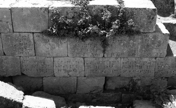
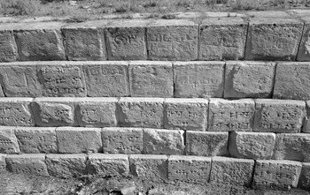
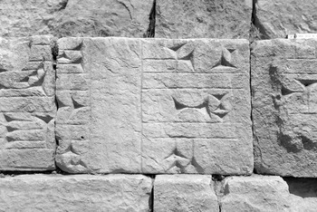
We now come to the largest and most problematical epigraphical complex from the aqueduct of Jerwan; following Jacobsen and Lloyd, we retain the label “inscription D”, although it is not certain that only one text is involved. On the SW facade, a sector of the outer masonry corresponding to two buttresses and three recesses for some 45 metres in length, juts markedly forward from the rest of the wall, almost to the point of seeming detached from the latter. This “distinctive treatment”, in Lloyd's words,Footnote 65 is “accentuated” by the fact this section of stonework is formed by a series of blocks of whitish limestone, approximately half of which are incised with clear and deep cuneiform signs, of a dimension almost double of those in inscription B, but indisputably pertaining to the same Assyrian monumental script. As a further curious feature, each of the inscribed blocks shows very few signs (between 1 and 4) placed on two, at the most three lines one above the other, divided by horizontal rulings. Moreover, in numerous cases the writing of the top or bottom line proves to have been “cut” in half horizontally, presumably for reasons which had to do with the uniform measurements (approx. 38 x 45 cm) required for the blocks in their visible arrangement.
If this “paradigmatic” aspect of the individual inscriptions on the blocks already appears in contrast with the other epigraphical material from Jerwan, it is the “syntagmatics” of the blocks themselves—i.e., their reciprocal arrangement in the wall within rows of masonry at different heights—which produces the greatest surprises. At a bird's-eye view, these blocks in cuneiform script challenge the observer with the following “unorthodox” features:
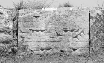
(a) they are haphazardly interspersed with uninscribed blocks, or at least with blocks presenting an uninscribed face (Fig. 16);
(b) in a few cases, they are placed at right angles to the normal direction of reading, or even at 180° degrees, i.e., with the script upside down (Fig. 17);Footnote 66
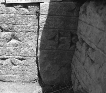
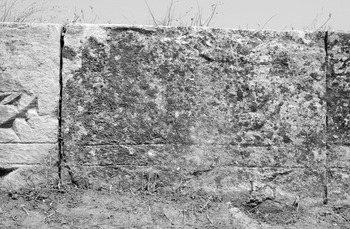
(c) in some cases, the inscribed surface has been reduced by a type of “rustication”, crudely effected by paring down strips of script on the four margins of the blocks (Fig. 18);Footnote 67
(d) in the buttressed sections, some written blocks are placed behind others, so that their script is only visible in part (Fig. 19);
(e) in the present state of the SW wall (presenting a few more partial collapses than in the 1930's), inscribed exemplars prove to have been placed within inner rows of the masonry, i.e., totally hidden to view for those observing the wall in antiquity;Footnote 68
(f) even where the inscribed blocks are correctly placed, complete, and located in adjacent positions, they do not in any case give rise to sequences of text which are intelligible at first sight.
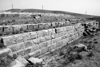
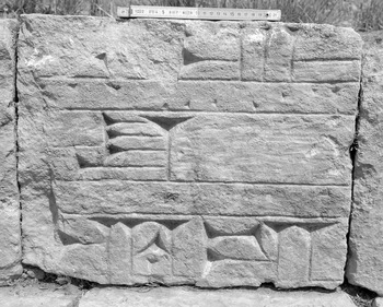
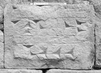
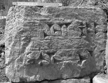
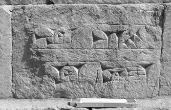
Inscription D: general view of sector 5 (photo ©MAIA)

Inscription D, block no. 88 (photo ©MAIA)

Inscription D, block no. 129 (photo ©MAIA)

Inscription D, block no. 189A (photo ©MAIA)

The so-called inscription D on the SW wall of Jerwan thus shows a monumental-contextual layout which finds no real parallels elsewhere in ancient Mesopotamia. Therefore, prior to a discussion on the possible Sitz im Leben of this text, a brief overview of past interpretations and an “on-site status report” born from the authors' 2012 investigation on the text, will be given.
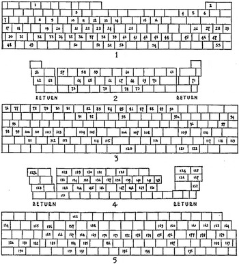
First and foremost, Jacobsen identified 202 blocks bearing cuneiform script within this section of masonry, providing them with a progressive numbering, and indicating their respective position in diagram form (Fig. 20).Footnote 69 Thereupon, and to the extent that it was possible, he attempted to order the written portions into single clauses by means of a painstaking re-composition of the hand-copies of the individual blocks, as in a jigsaw puzzle.Footnote 70 In his search for parallels, the royal inscriptions of Sennacherib were obviously the first choice, and these quickly bore fruit: Jacobsen was able to retrieve the name of the Chaldean ruler Marduk-apla-iddina, as well as of some toponyms which referred unequivocally to Sennacherib's texts.Footnote 71 By observing the vertical rulings in some fragments, Jacobsen deduced that the original text could have comprised two parallel columns of writing; and by taking account some double horizontal rulings as possible borders of the inscription, as well as of the measures of the height of the inscribed blocks, he concluded that the entire text could have comprised nine courses of blocks.Footnote 72
Jacobsen's diagram of the inscribed blocks on the SW wall. Reprinted from Jacobsen and Lloyd Reference Jacobsen and Lloyd1935, p. 24, fig. 7, courtesy of the Oriental Institute of the University of Chicago

These first crucial results were taken up and refined in the late 1990s by Eckart Frahm in his preparatory survey of the royal inscriptions of Sennacherib.Footnote 73 Frahm managed to reconstruct a few complete lines of D, estimating an average of 16–21 signs per line in the entire text. He believed that there could have been at least three columns; and did not even rule out that the script could have “turned” beyond the corner of some blocks, as if the inscription were placed on a wall endowed with edges.Footnote 74 As further pointed out by Frahm, there can be no absolute certainty on the number of individual inscriptions of Sennacherib (whether only one, or more) represented by the blocks of D—since this feature is also obscured by the apparent standardization of the sign-shapes in all copied fragments.Footnote 75
Finally, Frahm tackled the problem of which military campaigns were described in D, an element that could suggest the date of composition of the text. He thus noted, following Jacobsen, that Sennacherib's first campaign of 704 b.c. against Marduk-apla-iddina is attested, albeit with some textual variants which do not appear elsewhere. The second campaign of 703 b.c. may also be made out, with an even greater degree of variation on the hitherto known versions, which were all prepared by the king's scribes after 700 b.c. Traces of subsequent campaigns, on the other hand, were not discernible to Frahm.Footnote 76 Equally of great interest was a further conclusion reached in Frahm's study: that in the limited portions of D which may be reconstructed as pertaining to Sennacherib's activities as a builder, there is no obvious intimation of work connected to the vast hydraulic program for Nineveh, which the king began planning after his Judean campaign of 702 b.c. Footnote 77
In practice, Frahm's in-depth philological work brought to light a series of negative textual indicators regarding the overall relationship between inscription D and the aqueduct, from various points of view. The text seems to celebrate phases of Sennacherib's reign prior to the building of the Jerwan aqueduct; and not only is there no apparent reference in the inscription to its construction, but even the vast architectural and engineering program in which it is to be fitted (and which began a decade earlier) goes totally unmentioned. This feature, of course, sets the content of inscription D fully apart from that of inscriptions B and C, while rather linking it with inscription A; and such a connection might be enhanced by the fact that—despite the great difference of A and D in script appearance and size—some exemplars of A were retrieved in close proximity with the SW wall and its constitutive text, as said above (§2).
In sum, inscription D remains enigmatic, and it seems to find no specific contextual correlation with its findspot. However, the on-site examination by the authors, which included (for the first time since 1935) a reappraisal of Jacobsen's methods, a detailed comparison of his numbering of the blocks with the visible evidence, and a full photographic coverage of the inscribed blocks, has yielded new results of some interest.Footnote 78 These results may be given in three distinct rubrics as follows:
A. Jacobsen's work procedure. Jacobsen subdivided the part of the SW wall bearing inscription D into five numbered sections, obviously following the progress of cleaning and digging operations from the wadi rim westward. These sections correspond to: (1) the easternmost recess, (2) the next buttress (with its right and left returns) to the west; (3) the next recess to the west; (4) the next buttress (with its two returns) to the west; (5) the westernmost recess. In other words, Jacobsen's section numbers are given in his diagram in an overall sequence from right to left for those facing the wall.
However, and curiously enough, Jacobsen numbered the inscribed blocks within sections 1–5 by rows (top to bottom) from left to right. This makes for curious, and not immediately intelligible, sequences: for example, block no. 55 is the easternmost inscribed one of the bottom row of section 1, but the next numbered block, no. 56, is the westernmost inscribed one on the top row of section 2. Moreover, this numbering—in combination with the published form of the diagram, in which each section is allotted a different space on the page—does not functionally illuminate the contiguities (horizontal or vertical) between blocks of different sections, especially at the junctions between recesses and buttresses. Thus, as observed by the present authors, blocks 76 ff. (in section 3) and 132 (in 4) are on the same line, as are blocks 91ff. (in 3) with 125 (in the right return of 4), and as is block 127a (in the left return of 4) with 179 (in 5).
In addition, Jacobsen's sequential numbering of the inscribed blocks is not foolproof. Possibly due to some haste in his examination and copying of the blocks, two cases reflect initial oversights: thus, he added no. 93a between 93 and 94 (and as will be said in C, below, with an erroneous copy), and no. 127a in the left return of section 4. Further, the left-to-right numbering arrangement is correctly followed for buttress no. 2, where the spatial sequence left return—face—right return is precisely kept row by row, but inexplicably not for buttress no. 4, where the numbering follows the succession right return—left return—face.
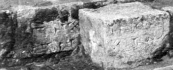
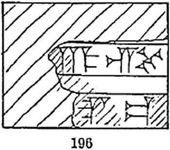
Finally, of the 202 numbered blocks,Footnote 79 Jacobsen's diagram only reaches to no. 195. Number 196 was assigned to an inscribed block visible in the inner row of masonry of section 1, which was photographed by Jacobsen;Footnote 80 it is curious that this high progressive number was given to a block lying right behind no. 2. As for nos. 197–202, there is no indication in the diagram concerning their whereabouts; the only mention that they were collapsed blocks lying at the foot of the wall is given with Jacobsen's copies (Pl. XXX).
B. The present state of the SW wall with inscription D (autumn 2012). General. Account must be taken of extended landfills all along the stonework, which at present limit the visibility of the lower rows of masonry. Specifically, the rows comprising blocks between nos. 48 and 55 (section 1, last row), nos. 62 and 75 (section 2, last two rows), nos. 111 and 122 (section 3, last two rows), nos. 143 and 152 (section 4, last two rows), and nos. 190 and 195 (section 5, last row) are at present buried for a part of their height or entirely (Fig. 21).
Inscription D, general view towards E, showing landfills (photo ©MAIA)

Section 1 (E recess), comprising blocks 1–55, is fairly well preserved. The top row lacks at least two blocks on its extreme right hand side, and thus inscribed block no. 2 (which was photographed by Jacobsen in pl. XIA) is no more in situ; a few blocks lie however face down below the wall in correspondence with this gap.
In the fifth row from the top, the inscribed block at the extreme right, no. 47, is not visible because it is covered by one of the fallen blocks.
Section 2 (E buttress), comprising blocks 56–75, is a shambles in its westernmost side, including the return. Inscribed blocks 56, 57, 62 and 63 are surely among those lying on the ground to the left of the buttress. The easternmost side of the buttress is, instead, in a relatively good state of preservation.
Section 3 (central recess), comprising blocks 76–122, is in a good state of preservation, save for some possible fissures produced by shrubs, etc. (thus e.g. block 107 has a wide central fissure affecting the two lowest lines, not attested in Jacobsen's copy).
Blocks nos. 117–19 are in place, but covered by the collapsed stonework in adjacent section 2 (left return; see above).
Section 4 (W buttress), comprising blocks 123–52. The right-hand (eastern) corner has suffered some collapse, with at least two blocks lying on the ground; thus block 142 is no longer in place, and the same goes for block 134.
A collapse also involves at least four outer blocks from the left (westernmost) return: among them are 127a, 128, 133 (the latter has been retrieved, more markedly chipped from the fall than in Jacobsen's time: see Figs. 22a–b) and presumably also 123. A further inscribed block in the jumble of masonry lying at the foot of the return presents a clear case of inscription A (cf. §3, above, and Fig. 7).
Inscription D, block no. 133, present state in collapse (photo ©MAIA)

Inscription D, block no. 133, copy by Jacobsen

Section 5 (W recess), comprising blocks 153–95. The collapse described above for section 4 also involves here the last four uninscribed blocks to the right of the top course, now lying on the ground. No block in the inner course, now visible due to the collapse, appears to be inscribed. The remainder of this section is in good state of preservation.
C. On-site and Assyriological gleanings. In Section 1, due to the gap described in B, above, the inner row of masonry now shows three adjacent inscribed blocks (a, b, c from left to right). Of these, Jacobsen could see only one, a = no. 196 (cf. A, above)—but curiously enough, his copy does not completely match his own photograph, and certainly not the one by the present authors (Fig. 23a–c). The other two (b, c) were invisible behind a block, and thus not copied by Jacobsen; they are completely covered by mould, quite likely due to moisture, and thus require cleaning to become sufficiently legible (Figs. 24, 25).
Inscription D, block no. 196, photo 1933. Reprinted from Jacobsen and Lloyd Reference Jacobsen and Lloyd1935, pl. XI A, courtesy of the Oriental Institute of the University of Chicago

Inscription D, block no. 196, copy by Jacobsen. Reprinted from Jacobsen and Lloyd Reference Jacobsen and Lloyd1935, pl. XXIX, courtesy of the Oriental Institute of the University of Chicago

Inscription D, block no. 196 (= a), present state (photo ©MAIA)

Inscription D, block b to the right of 196a (photo ©MAIA)

Inscription D, block c to the right of 196b (photo ©MAIA)

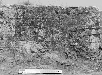
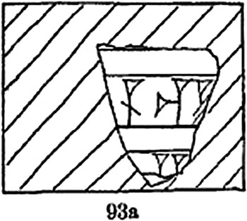
In Section 3, top row, two blocks to the right of no. 90, there is a further, half-preserved, inscribed block, placed upside down, which may be dubbed 90a. This block was not marked by Jacobsen in his diagram, but was erroneously copied as no. 93a (Fig. 26a–b). In point of fact, in the position indicated by Jacobsen for no. 93a in the second row from the top, there is a block (a rectangular fragment placed on its left-hand side, bearing signs on three lines, although a large crack virtually separates the bottom line), which was not copied as such (Fig. 27). Jacobsen's mix-up could have been due to haste, since 90a and 93a are almost one above the other on their respective rows.
Inscription D, block no. 90a, present state in situ (photo ©MAIA)

Inscription D, block no. 90a, copied by Jacobsen as no. 93a. Reprinted from Jacobsen and Lloyd Reference Jacobsen and Lloyd1935, pl. XXIV, courtesy of the Oriental Institute of the University of Chicago

Inscription D, block corresponding to no. 93A in Jacobsen's diagram (photo ©MAIA)

In Section 5, at the end of fourth course from top, to the right of no. 189, an inscribed block is visible in its left half, while the remainder lies behind the blocks of the left hand return in buttress no. 4; the block is not marked as such in Jacobsen's diagram, and may be dubbed 189a.Footnote 81
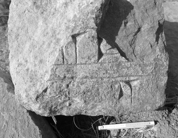
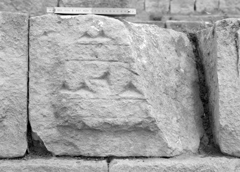
Rewriting: blocks 14, 77 and 85 (Figs. 28, 29, 30) show quite clear evidence of rewriting. Specifically, numerous residual markings indicate that a previous text, bearing smaller and possibly denser script, had been incised on the stone but subsequently erased, to be replaced by the large-size signs of D. Such markings, while clearly visible on the photographs, are systematically omitted in Jacobsen's copies (e.g. the -ri- in the bottom row of no. 77 shows the presence of an unexpected vertical wedge in smaller script).
Inscription D, block no. 14 (photo ©MAIA)

Inscription D, block no. 77 (photo ©MAIA)

Inscription D, block no. 85 (photo ©MAIA)

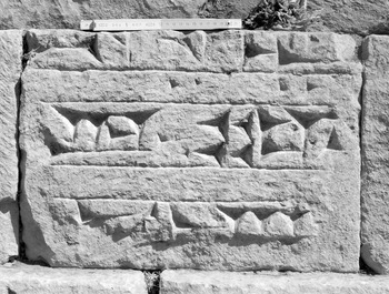
Minor blemishes occur here and there in Jacobsen's copies: thus, in block 84, the MEŠ is complete, with three obliques (Fig. 31); in 125, traces of a sign preceding the -ib- are visible, but not copied (Fig. 32); in 166, an inner vertical wedge is omitted (Fig. 33).
Inscription D, block no. 84 (photo ©MAIA)

Inscription D, block no. 125 (photo ©MAIA)

Inscription D, block no. 166 (photo ©MAIA)

As already noted,Footnote 82 two further blocks of the inscription (d, e = Figs. 34–35) were identified by the present authors out of context, in the Dohuk Museum.
Inscription D, block d, Dohuk Museum (photo ©MAIA)

Inscription D, block e, Dohuk Museum (photo ©MAIA)

6. The Sitz im Leben of inscription D
Inscription D cannot fail to impress the informed visitor of Jerwan by its thoroughly incoherent and disorderly aspect. The search for the causes behind the particular arrangement of the blocks bearing this inscription within a specific and delimited sector of the SW wall was undertaken by Lloyd at the outset of the volume. He speculated that the blocks “appear to have been re-used here after being discarded from their original purpose and content”.Footnote 83 More specifically, Lloyd estimated that this uniquely jutting sector of masonry should have reached inside the wall more or less to a depth corresponding with the inner parapet wall at the top of the structure; he thus offered, albeit tentatively, the following functional explanation: “At some time when the aqueduct was in use the parapet had been breached by the pressure of the water, or possibly by a hostile attack, and the outrush of water had carried away some of the stonework beneath. The breach had been patched with stones discarded from some other building, many of them still bearing traces of inscriptions appropriate to it”.Footnote 84
This explanation of the sector of the SW wall bearing inscription D as a filling to repair a breach, however well thought out in its possible mechanics,Footnote 85 leaves some open questions, which the present authors have chosen to tackle from the perspective of the relationship between the architecture of the studied monument and its inscriptions. In essence, such open questions may be reduced to two points, which were not addressed in full by Jacobsen and Lloyd: whence should the “stones discarded from some other building” have originated? And further, at what moment in time should the alleged breach and its repair have occurred? The two points are more closely interlocked than they may seem at first sight, and give rise to a finite set of plausible solutions.
To answer the first question (“whence?”), we may go back to the presence of blocks with inscription A within the stonework of D itself. As seen above (§3), this brief inscription refers back to a “palace” of Sennacherib. But where could this palace have been? And should these mentions compel us to hypothesize the transportation of stonework from a previous palatial structure of Sennacherib, or is there also scope for other possibilities? The distance between Nineveh and Jerwan (more than 40 km) seems too large for the transfer over land of hundreds of bulky blocks, such as might have fallen out of use in the capital city.Footnote 86 The distance between the aqueduct and Khinis, instead, is much smaller, as seen above (§4); moreover, after the digging of “Sennacherib's canal”, the waterway itself could well have been used to convey the stonework on barges. In addition, the hypothesis of a transportation from Khinis might benefit from a preliminary chemico-physical examination analysis of the blocks of the aqueduct, which prove to be of a similar limestone to the material which was quarried on the slope above the monumental complex.Footnote 87 It is therefore plausible to suggest that Khinis was the place of origin of a series of large limestone slabs bearing an inscription with Sennacherib's res gestae during his earliest campaigns, possibly as a decorative component of a planned palatial structure. Following a change of plans on the part of the king (or, alternatively, a scribal actualization of the narration of his feats), these slabs could have been cut up in a vast number of blocks of similar shape and weight, and thereupon floated downriver to be employed in the building of the Jerwan aqueduct.
In any case, whether they came from the south on ox-carts or from the north on barges, no feature contradicts or even hinders the proposal that these blocks inscribed with royal feats were intentionally employed to repair the alleged breach in the SW wall of the hydraulic structure, in the authors' opinion. The question is rather whether the blocks were already in situ when the breach occurred. This seems more plausible than that they were specifically brought to Jerwan for the emergency. In this case it may be that the blocks bearing the 200 plus fragments of inscription D formed part and parcel of the stonework of the structure, albeit not as visible inscriptional components therein. In other words, these inscribed blocks could have arrived at Jerwan with countless others during the building operations of the titurru, but were thereupon set up with their engraved faces turned toward the interior of the masonry. Their reappearance would thus have occurred only at the moment of the structural collapse in the SW wall, when they were put back up at random, together with other uninscribed exemplars, for an urgent “patch” to the wall itself.Footnote 88
***
Let us now take up the second point (“when”), regarding the possible date for the operation of architectural restructuring which brought the SW wall to the particular appearance it shows today. We may start out from the theoretical possibility that Assyrian technicians and experts of Sennacherib's time were the ones who repositioned inscription D. This scenario seems highly improbable, however; it rests on the assumption that inscription D was already visible in situ at the moment of the collapse, and that the intention was that of repositioning it as written decoration of the aqueduct, although the operation was carried out in an incompetent manner. On the contrary, research (§5, above) has shown that inscription D had no connection with the structure, either chronologically or in its contents; thus it is unlikely that this inscription had been set up by Sennacherib's men in the SW wall in a visible position before the breach in the structure occurred. But even supposing that the written blocks had come to light only at the moment of the structural collapse, had the architectural repair taken place during Sennacherib's lifetime not even the most slipshod chief mason would have dared to place the blocks extolling the king's deeds in a haphazard order, without consulting the learned ummānus of the time.
Thus a more plausible option is that the repair of the breach occurred in a phase following the reign of Sennacherib. In this light, if one takes into account the major political influence wielded by Sennacherib's most recent wife, Naqi'a/Zakutu, who not only guided their son Esarhaddon (680–668 b.c.) to the throne, but went on to be an energetic grandmother for Aššurbanipal (668–627 b.c.), it does not seem too bold to extend the notion that a random resetting of the inscribed blocks in the SW wall would have represented a taboo for the values of Empire and of the ruling dynasty all through the seventh century.
We should thus look to the post-Assyrian period. In the aftermath of the fall of Nineveh in 612 b.c., the Navkur plain must have witnessed the rampage of Median and Chaldean armies, finally victorious over the hated enemy. A mere century later, the military and administrative forces of the Achaemenid empire surely passed through this district, along the “royal roads” linking Persia and the Mediterranean. In any case, Arrian and other Classical authors intimate that the plain crossed by the Gomel river had largely gone back to a rural economy of subsistence, when Alexander chose it as strategic area to face the army of Darius III in the decisive pitched battle of Gaugamela of late 331 b.c. After this, the region should have formed part of the district of Adiabene in its changeable political status.
So the question is: which protagonists of the “post-Assyrian” phase (or perhaps even the “post-Achaemenian” one) were responsible for the crude repair to the ancient titurru, which had collapsed for a significant stretch, and in the process brought to light the inscribed blocks, thereupon placing them at random in the wall, perhaps with a merely decorative function? We cannot say: but quite surely they were peoples for whom the name of Sennacherib was by then lost in the mist of legend,Footnote 89 and who regarded Assyrian cuneiform script as little more than abracadabra—to the extent that at nearby Khinis they (or others like them) had no qualms in erasing an Assyrian inscription in a rectangular panel on the rocky face of the river valley, and filling its space with a bas-relief depicting a rider in Hellenistic, and/or Parthian, style.Footnote 90
On the other hand, it must be noted that these peoples actively engaged in the restoration of the Jerwan structure; and they did so for an obviously utilitarian purpose. It is easy to suppose that the original function of the artefact as an aqueduct had been long forgotten, as must have also been the case for most of Sennacherib's abandoned embankments and stone-lined canals for water conveyance in northern Assyria. Rather, the imposing limestone construction must have struck these later peoples as a well-executed bridge over the deep ravine of a wadi; as a useful paved route for the passage of horses and chariots above a seasonal stream, occasionally swollen and impetuous. At least for the time being, therefore, in the absence of more specific evidence, we may surmise that the Jerwan aqueduct was viewed as no more and no less than a convenient military causeway by the later peoples who repaired its masonry for the last time, be they Achaemenids, Seleucids, Arsacids or Sasanians.