INTRODUCTION
Carbon exists as three isotopes in nature with two nonradioactive isotopes (12C and 13C) and one radioactive isotope (14C or radiocarbon). Modern surface seawater radiocarbon is a combination of natural and bomb-produced radiocarbon. Natural radiocarbon originates from the collision of cosmic rays with nitrogen in the upper atmosphere, while bomb-produced radiocarbon derives from atmospheric nuclear weapon testing during the 1950s and 1960s (Nydal and Lovseth Reference Nydal and Lovseth1983; Druffel Reference Druffel1987). 14C produced in the atmosphere quickly forms 14CO then14CO2 after reacting with oxygen. This atmospheric 14CO2 subsequently diffuses into seawater due to air-sea gas exchange (equilibration normally takes around 10 years) (Druffel and Linick Reference Druffel and Linick1978; Druffel and Suess Reference Druffel and Suess1983). The uptake of CO2 and therefore 14CO2 throughout the global ocean leads to the redistribution of bomb-derived 14C.
Porites sp. corals are long-lived (up to 300+ years), and their skeletons record the 14C content of the dissolved inorganic carbon (DIC) in the surrounding water (i.e., coral Δ14C = sea water Δ14C, after correcting for mass-dependent fractionation). This provides an opportunity to examine oceanographic and climate variability using radiocarbon as a seawater tracer over multiple time scales. Many studies have used the 14C in coral skeletons to track ocean circulation (Druffel Reference Druffel1987; Druffel and Griffin Reference Druffel and Griffin1995, Reference Druffel and Griffin1999; Guilderson et al. Reference Guilderson, Schrag, Kashgarian and Southon1998, Reference Guilderson, Schrag, Goddard, Kashgarian, Wellington and Linsley2000, Reference Guilderson, Fallon, Moore, Schrag and Charles2009; Fallon and Guilderson Reference Fallon and Guilderson2008; Andrews et al. Reference Andrews, Asami, Iryu, Kobayashi and Camacho2016a; Hirabayashi et al. Reference Hirabayashi, Yokoyama, Suzuki, Miyairi and Aze2017a; Hirabayashi Reference Hirabayashi, Yokoyama, Suzuki, Miyairi, Aze, Siringan and Maeda2017b; Wu and Fallon Reference Wu and Fallon2020). Seawater 14C has also been shown to be sensitive to large-scale climate phenomena such as the El Niño-Southern Oscillation (ENSO) due to the movement of 14C labelled water (Druffel and Griffin Reference Druffel and Griffin1993, Reference Druffel and Griffin1995; Guilderson and Schrag Reference Guilderson and Schrag1998). Coral Δ14C records can also be used as a temporal reference series to aid in dating marine organisms with calcified structures (Fallon and Guilderson Reference Fallon and Guilderson2005; Andrews et al. Reference Andrews, Siciliano, Potts, DeMartini and Covarrubias2016b, Reference Andrews, Humphreys and Sampaga2018).
Numerous coral Δ14C records have been reported from the tropical Pacific Ocean, however, many of these records either have low temporal resolution or are relatively short in length, limiting the complete history of bomb 14C uptake and decline. Water sampling programs such as the World Ocean Circulation Experiment (WOCE) (Key et al. Reference Key, Quay, Jones, McNichol, vonReden and Schneider1996) provide a low temporal resolution snapshot of seawater 14C concentrations over the past decades but cannot inform seasonal and interannual variations of seawater 14C. Long-term continuous coral Δ14C records can add critical information to these water sampling programs by providing a detailed high-resolution history of oceanic 14C uptake at the coral location. Such knowledge is essential to better understand the large-scale oceanic circulation.
Long records of coral Δ14C from the southern GBR have been documented in several publications by Druffel and Griffin (Reference Druffel and Griffin1993, Reference Druffel and Griffin1995, Reference Druffel and Griffin1999). In this study, we provide an up to date seawater Δ14C history from a Porites coral collected at Masthead Island, southern GBR (Figure 1). This bi-monthly Δ14C record provides detailed information about the seasonal and interannual ocean circulation off northeast Australia on multiple time scales. The coral Δ14C results imply that air-sea gradients have evolved to a new state, with surface seawater 14C now higher than atmospheric 14CO2, suggesting that the surface ocean can be a source of 14C to the atmosphere in areas of CO2 outgassing.
General surface circulation in the Pacific and off northeast Australia. The broad South Equatorial Current (SEC) flows westward and splits into two parts around latitude 15°S. The northern SEC branch forms the Hiri Current, and the southern branch forms the East Australian Current (EAC), which is the dominant current in the GBR region (Godfrey et al. Reference Godfrey, Cresswell, Golding and Pearce1980; Wijeratne et al. Reference Wijeratne, Pattiaratchi and Proctor2018; Oke et al. Reference Oke, Roughan, Cetina-Heredia, Pilo, Ridgway, Rykova, Archer, Coleman, Kerry, Rocha, Schaeffer and Vitarelli2019). A red star represents sampling sites used in this study. MI, HI, LM and AR stand for Masthead Island, Heron Island, Lady Musgrave and Abraham Reef, respectively. NEC is the North Equatorial Current and ECC is the Equatorial Counter Current. Blue arrows show the directions of southeast Trade winds from April to November and weaker northwest monsoons from December to March in northeast Australia (Steinberg Reference Steinberg2007). This map was produced using Qgis. (Please see electronic version for color figures.)

MATERIALS AND METHODS
Coral Location, Preparation, and Age Model
A modern Porites sp. coral core (MAS01E) was collected from Masthead Island (23°31'57''S, 151°44'45''E) at a water depth of 4.5 m in August 2017 (Figure 1). Masthead Island is located 60 km from the Australian Coast and may occasionally be influenced by major river flood events (Cantin et al. Reference Cantin, Fallon, Wu and Lough2018). Standard techniques were used to prepare the coral slices, which are cut parallel to the axis of growth (Lough and Barnes Reference Lough and Barnes1990). Annual density banding from X-ray images were counted from the top (year of collection) to provide a preliminary age model. U/Ca seasonal cycles measured by Laser ablation–inductively coupled plasma–mass spectrometry (LA–ICP–MS) analysis were used to fine-tune this age model by matching U/Ca maxima to the winter sea surface temperature (SST) minima (Fallon et al. Reference Fallon, McCulloch, van Woesik and Sinclair1999). Age model errors are estimated to be ±2 months from the geochemical analysis. Geochemical data for the age model were reported in Cantin et al. (Reference Cantin, Fallon, Wu and Lough2018).
14C Analysis
Samples for 14C analysis were drilled following the main growth axis. The pre-set track has a 2 mm width, 2.5 mm depth, and 2 mm increment, which corresponds to ∼5 samples per year. 5 mg of coral sample powders was placed in individual VacutainerTM tubes, evacuated, heated and acidified with 0.2 ml 85% orthophosphoric acid at 80°C. Generated CO2 was purified and reduced to graphite by excess H2 using Fe as a catalyst. Graphite samples were pressed into targets and measured by the single-stage accelerator mass spectrometer (SSAMS) at the Australian National University (Fallon et al. Reference Fallon, Fifield and Chappell2010). All results are background corrected using 14C-free marble and corrected using AMS online δ13C. 14C results are reported as decay-corrected Δ14C (Stuiver and Polach Reference Stuiver and Polach1977).
RESULTS
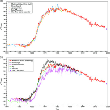
Figure 2 shows the surface ocean Δ14C values as recorded in the Masthead Island coral, spanning the years 1945–2017. Δ14C values averaged –49‰ in the pre-bomb period (1945–1953), with a linear decrease of 0.82‰ per year from 1945 to 1953, revealing a moderate Suess effect (Tans et al. Reference Tans, Dejong and Mook1979). Δ14C values increased steadily from 1959 to 1970 as a result of the atmospheric bomb 14C signal. Δ14C values reached the post-bomb peak plateau in the late 1970s, and then Δ14C values decreased gradually to ∼40.3‰ by 2017, approximately corresponding to a linear decrease of 2.9‰ per year (R2=0.97, linear regression calculated from 1982 to 2017).
Comparison of Δ14C records from Masthead Island (this study) and (a) southern GBR corals (Heron Island, Lady Musgrave, Abraham Reef [Druffel and Griffin Reference Druffel and Griffin1993, Reference Druffel and Griffin1995, Reference Druffel and Griffin1999]), and (b) selected southern Pacific corals (Fiji [Toggweiler et al. Reference Toggweiler, Dixon and Broecker1991], Vanuatu [Fallon et al. Reference Fallon, Guilderson and Caldeira2003], Solomon Island [Guilderson et al. Reference Guilderson, Schrag and Cane2004], Rarotonga [Guilderson et al. Reference Guilderson, Schrag, Goddard, Kashgarian, Wellington and Linsley2000]).

DISCUSSION
Radiocarbon Time Series in the Southern GBR and Regional Variations
Figure 2a shows a comparison between Masthead Island Δ14C record and records from the other southern GBR corals which only extend through the 1980s (Heron Island, Lady Musgrave, Abraham Reef [Druffel and Griffin Reference Druffel and Griffin1993, Reference Druffel and Griffin1995, Reference Druffel and Griffin1999]). The Masthead Island 14C record is similar to other coral records in the southern GBR (Figure 2a) in general, confirming the East Australian Current (EAC) as the primary water mass that feeds the central and southern GBR. However, some short-scale variations are also evident. The Masthead Island post-bomb Δ14C values are similar to Heron Island but slightly higher than Lady Musgrave and Abraham Reef. Druffel and Griffin (Reference Druffel and Griffin1995) attributed lower values in Abraham Reef to the nearby shelf break (Andrews and Gentien Reference Andrews and Gentien1982) which upwells low Δ14C water to Abraham Reef. Although Masthead Island and Heron Island are physically close to each other (Figure 1), Δ14C values from the two locations show small differences in late 1970s, with two measurements from Heron Island showing high Δ14C values not reproduced in the Masthead Island coral (Figure 2a).
Figure 2b compares the Masthead Island Δ14C record to other southern Pacific coral records (Fiji [Toggweiler et al. Reference Toggweiler, Dixon and Broecker1991], Vanuatu [Fallon et al. Reference Fallon, Guilderson and Caldeira2003], Solomon Island [Guilderson et al. Reference Guilderson, Schrag and Cane2004], Rarotonga [Guilderson et al. Reference Guilderson, Schrag, Goddard, Kashgarian, Wellington and Linsley2000]) which are all influenced by the South Equatorial Current (SEC). The Solomon Island record has the lowest Δ14C values for all these locations (Figure 2b), representative of lower 14C waters from the equatorial branch of the SEC due to equatorial upwelling. Δ14C records from Masthead Island and Fiji are nearly identical (Figure 2b) for the post-bomb period, revealing that both sites are fed by the southern branch of the SEC (higher 14C waters). For the pre-bomb period when Δ14C was weakly controlled by air-sea exchange, the Δ14C record from Fiji is lower (Figure 2b), Toggweiler et al. (Reference Toggweiler, Dixon and Broecker1991) attributed this to older water from Peru upwelling. The Masthead Island Δ14C values are mid-way between the values from Rarotonga and Vanuatu from 1967 to 1978 (Figure 2b). The elevated post-bomb peak recorded in Rarotonga reflects a strong air-sea exchange due to longer residence time of surface water in the south Pacific gyre (Guilderson et al. Reference Guilderson, Schrag and Cane2004). The Rarotonga record converges with the Masthead Island record in the late 1970s as the atmospheric 14C record is decreasing sharply reducing the air-sea 14C gradient while the Masthead Island record displays the regional seawater 14C.
Seasonal and Interannual Variability
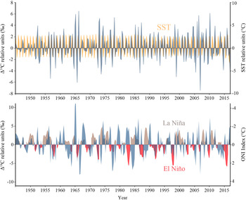
A high-pass filter was subjected to the Δ14C time series to extract the seasonal (2.5-year window, frequency ranging from 0.1–0.5) and interannual (20-year window, frequency ranging from 0.012–0.5) Δ14C variations to compare with SST and ENSO records (Figure 3). Results show that the Masthead Island Δ14C exhibits clear seasonal and interannual variability throughout the entire length of the time series. The amplitude varies from 2–10‰, with small amplitude (<5‰) being dominant. Masthead Island Δ14C is in phase with SST most of the time during post-bomb period. Synchronous changes between Δ14C and SST suggest seasonally different water masses bathed this location. The Masthead Island Δ14C seasonal and interannual variability may result from seasonal latitudinal shifts of the SEC bifurcation and/or seasonal wind reversal. The SEC latitudinal bifurcation exhibits significant seasonal variations, with the southernmost position (16.4°S) occurring in April and northernmost position (∼13.9°S) occurring in December (Zhai et al. Reference Zhai, Hu, Wang and Wang2014). A southern shift of the bifurcation latitude during wintertime may increase the amount of low Δ14C waters from the upwelling-affected SEC, while a northern shift of the bifurcation latitude may bring in more non-upwelling waters from the Coral Sea which has higher Δ14C. Secondly, the central and southern GBR regions are influenced by seasonal wind reversals (Figure 1). From April to November, southeast trade winds are prevalent which move surface waters towards the northwest (onshore) (Steinberg Reference Steinberg2007), suppressing the poleward-flowing EAC. 14C is usually depleted in riverine dissolved inorganic carbon compared to seawater because it originates from old terrestrial organic matter which release CO2 due to respiration and photo-oxidation. Masthead Island is near the Fitzroy and Calliope River catchments, so large freshwater input can possibly lower the surface ocean 14C values in big floods. Therefore, the weak northward surface current during wintertime may transport lower Δ14C water to Masthead Island. During Austral summer (December to March), the northwest monsoon is more dominant, and the southern GRB region is mainly fed by the EAC (Steinberg Reference Steinberg2007). It should be noted that northwest monsoons can also induce wind-driven shelf edge upwelling (Andrews and Gentien Reference Andrews and Gentien1982). The variable timing and extent of upwelling may partially account for the out of phase association between Δ14C and SST records. Masthead Island is located ∼60 km offshore (inner continental shelf), which is unlikely to be affected by short-lived upwelling events. However, major upwelling events which occur every few years (e.g., during ENSO events) can extend to the entire continental shelf and modify shelf waters (Furnas and Mitchell Reference Furnas and Mitchell1996), thus confounding the Masthead Island Δ14C seasonality in some years. After 1995, the phasing between Δ14C and SST records becomes more variable (Figure 3), probably reflecting the changes in subsurface dynamics. The convective overturning of higher Δ14C values between subsurface waters and the overlying surface waters was demonstrated in some Pacific 14C depth profiles, which show higher 14C in the mixed layer than in the surface water (Key Reference Key1996; Key et al. Reference Key, Quay, Jones, McNichol, vonReden and Schneider1996, Reference Key, Quay, Schlosser, McNichol, von Reden, Schneider, Elder, Stuiver and Ostlund2002; Kumamoto et al. Reference Kumamoto, Murata, Kawano, Watanabe and Fukasawa2013).
Comparison between southern GBR surface ocean Δ14C record, SST record and ONI (ocean Niño index). Upper panel compares Δ14C record with SST record after FIR high-pass filtering (2.5-year window, frequency ranging from 0.1–0.5). Lower panel compares Δ14C record with ONI values after FIR high-pass filtering (20-year window, frequency ranging from 0.012–0.5). Blue color represents filtered Δ14C (relative units only), orange color represents filtered SST (relative units only), red color represents El Niño, grey color represents La Niña.

The relationship between seawater 14C and ENSO is quite variable in the South Pacific. Druffel and Griffin (Reference Druffel and Griffin1993, Reference Druffel and Griffin1995) found that some El Niño events resulted in the displacement of low-Δ14C waters into the southern GBR which lowered Δ14C values at Abraham Reef. However, in other locations, such as the Galapagos (Guilderson and Schrag Reference Guilderson and Schrag1998), corals record higher Δ14C values during most El Niño events because of the suppression of upwelling and long retention time of 14C in surface water. The association of the Masthead Island 14C record with ENSO is similar to the Abraham Reef coral record during post-bomb periods (Figure 3). Masthead Island Δ14C values decreased during most El Niño events such as 1972–1973, 1976–1977, 1991–1992, and 1997–1998 but increased during other El Niño events such as 1982–1983. This may be because some strong ENSO events caused the cessation of equatorial upwelling (Guilderson and Schrag Reference Guilderson and Schrag1998; Guilderson et al. Reference Guilderson, Schrag, Kashgarian and Southon1998), so seawater Δ14C values were higher compared to normal years.
Long-Term Oceanic 14C Uptake
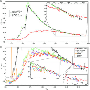
Oceanic 14C is controlled by air-sea exchange, lateral advection and shallow-to-deep ocean exchange. Oceanic uptake of bomb-derived 14C increased sharply in the 1960s and early 1970s, continued during the 1980s, but slowed down throughout the 1990s and 2000s (Figures 2 and 4). During the 1960s and early 1970s, post-bomb Δ14C in the surface ocean was primarily affected by CO2 gas exchange with the atmosphere due to the large air-sea Δ14C gradient (Figure 4a). Spatially variable Δ14C values (Figure 2) indicate 14C is more affected by ocean dynamics starting from the middle 1970s due to the weakening of air-sea Δ14C gradients (Figure 4a).
Comparison of Δ14C records between Masthead Island (this study), atmospheric record (Hua et al. Reference Hua, Barbetti and Rakowski2013) and four north Pacific coral sites (Guam [Andrews et al. Reference Andrews, Asami, Iryu, Kobayashi and Camacho2016a], Kure Atoll [Andrews et al. Reference Andrews, Siciliano, Potts, DeMartini and Covarrubias2016b], Houbihu and Palaui [Ramos et al. Reference Ramos, Goodkin, Druffel, Fan and Siringan2019]). The insert in panel (a) shows the close-up comparisons between southern atmospheric 14C and northern atmospheric 14C after 1990, and between Masthead Island record with atmospheric record after 1990. The left insert in panel b shows Masthead Island and Kure Atoll converged with southern atmospheric 14C around 2000, and were later on joined by Houbihu in 2004. The right insert in panel (b) shows Masthead Island and Palaui 14C are higher than atmospheric 14C after 2010.

The rise and the start of post-bomb peak plateau of Masthead Island Δ14C are delayed by ∼2 years compared to coral records from the equatorial and North Pacific (Figure 4b), which is in agreement with the delay between Northern and Southern Hemisphere Δ14C values due to atmospheric troposphere mixing (Hua et al. Reference Hua, Barbetti and Rakowski2013). Masthead Island Δ14C peaks and levels off from 1975 to 1982 (Figures 2 and 4), suggesting either the mixing with subsurface water is less intense during this time period or subsurface water is no longer severely depleted in 14C, i.e., the vertical gradient in Δ14C seawater has continued to decrease through time. After reaching the peak in 1982, Masthead Island Δ14C values began decreasing at a rate of ∼3.0‰ per year from 1982 to 2006 but slow to a rate of ∼1.4‰ per year from 2006 to 2017 (Figure 2), revealing a change in the vertical inventories of the bomb 14C in the GBR region (i.e., subsurface ocean starts to contain more young/high 14C water) (Kumamoto et al. Reference Kumamoto, Murata, Kawano, Watanabe and Fukasawa2013).
After 1985, the air-sea 14C gradient decreased but remained relatively constant among different locations (Figure 4b). The gradually emerging differences between Masthead Island, Guam and Kure Atoll coral records (Figure 4b) may therefore primarily reflect lateral advection and shallow to deep water exchange. Guam may be subject to increased inputs of lower 14C waters due to equatorial upwelling, resulting in the Guam coral Δ14C values decreasing more rapidly than Masthead Island during the mid-1990s (Figure 4b). The similarity between Masthead Island and Kure Atoll after the 1990s suggests the higher latitude regions had accumulated more bomb-derived 14C, making the water less susceptible to dilution/modification from surrounding seawater with different 14C signatures. In the 1990s, the Northern Hemisphere atmospheric Δ14C values became lower than those of Southern Hemisphere (Figure 4a, inset) (Hua et al. Reference Hua, Barbetti and Rakowski2013), due to the greater release of anthropogenic CO2 in the Northern Hemisphere. GBR seawater Δ14C reached atmospheric level during the 2000s and started to overtake atmospheric Δ14CO2 after 2010 (Figure 4). Even though the atmospheric 14C has not been extended to 2018 (Hua et al. Reference Hua, Barbetti and Rakowski2013; Turnbull et al. Reference Turnbull, Fletcher, Brailsford, Moss, Norris and Steinkamp2017), the downward trend of atmospheric 14C does not cease because burning of 14C–free fossil fuels has continued and increased. Surface water Δ14C samples from One Tree Island (30 km offshore from Masthead Island) collected in November 2018 further confirmed that surface ocean Δ14C is much higher than the atmosphere (Figure 4a). The air-sea Δ14CO2 gradient reversed from positive to negative after 2010. The reversed gradient suggests that the ocean could start to return bomb-derived 14C back to the atmosphere if the CO2 gradient is favorable and approach a significantly different state of equilibrium compared to the pre-industrial and pre-bomb eras.
Utilizing GBR Coral 14C Records as a Dating Reference Series
Bomb-derived 14C recovered from hermatypic corals can be used to estimate the ages of other marine calcifying organisms (Fallon and Guilderson Reference Fallon and Guilderson2005; Andrews et al. Reference Andrews, Siciliano, Potts, DeMartini and Covarrubias2016b, Reference Andrews, Humphreys and Sampaga2018). Bomb 14C dating of marine organisms can be done by projecting the measured 14C values to the 14C reference coral records using marker points (e.g., year of collection) (Fallon and Guilderson Reference Fallon and Guilderson2005; Andrews et al. Reference Andrews, Humphreys and Sampaga2018). Accurate estimation of the longevity and/or age of marine organisms is crucial to help manage exploited marine populations and comprehensively understand oceanographic/climate variability. The Masthead Island Δ14C record provides a high-precision seawater 14C history in the GBR regions covering pre-bomb era (1945) to the present (2017). The Masthead record in conjunction with the published records by Druffel and Griffin (Reference Druffel and Griffin1993, Reference Druffel and Griffin1995, Reference Druffel and Griffin1999) offer an opportunity to robustly date marine organisms collected in the GBR region and better understand the evolution of the GBR ecosystems.
CONCLUSION
Oceanic uptake of bomb-derived 14C can provide useful information on air-sea diffusion and seawater mixing dynamics. After the conclusion of bomb testing, the redistribution of bomb-derived 14C has been robustly recorded by corals throughout the tropical oceans. The Masthead Island coral record is in agreement with previously published coral records in the GBR and extends the record from the 1980s to 2017 confirming that the southern GBR is mainly influenced by the EAC. Δ14C seasonality in the Masthead Island coral may result from changing influences of the SEC due to the seasonal shift of the bifurcation latitude and seasonal wind reversal. The extended Δ14C time series through 2017 also suggests oceanic 14C is no longer primarily controlled by air-sea exchange in the past two decades, instead, shallow-to-deep ocean exchange is playing a more important role. The air-sea diffusion may reach a new state of equilibrium as a result of the bomb-derived 14C and continuous fossil fuel emissions. The Masthead Δ14C record provides a continuous and validated high-resolution 14C timeseries, making the age estimate of other marine organisms possible in the GBR region.
ACKNOWLEDGMENTS
We thank constructive comments from two anonymous reviewers that improved the manuscript. YW is supported by ANU PhD Scholarship and ANU Supplementary Scholarship. Funding for the project was provided by the ANU Radiocarbon Laboratory, and Gladstone Healthy Harbour Partnership Project ISP019. Data can be found in the supplementary material.
Supplementary material
To view supplementary material for this article, please visit https://doi.org/10.1017/RDC.2020.141