

Zika virus (ZikaV) is a life-threatening infectious type virus which causes serious health related issues. ZikaV is a little-known arbovirus that was initially identified in Uganda in 1947 in a rhesus monkey used as a sentinel during sylvatic yellow fever surveillance in the Zika forest in Uganda. In 1948, it was isolated from a lot of A. Africanus mosquitoes in the same forest (Reference Dick, Kitchen and Haddow1). It was first found in humans in 1952 in Uganda and the United Republic of Tanzania. According to the World Health Organization (WHO), the ZikaV transmission has been detected in a total of sixty-four countries and territories from January 1, 2007, to April 13, 2016 (2). In Colombia, 58,838 cases of ZikaV are identified from September 22, 2015, to March 19, 2016 (Reference Sarmiento-Ospina, Vsquez-Serna, Jimenez-Canizales, Villamil-Gmez and Rodriguez-Morales3).
The symptoms of ZikaV disease (ZVD) are similar to Dengue, and Chikungunya, which include mild fever, rashes, conjunctivitis, arthralgia, arthritis, muscle and joint pain, malaise, and headache. The WHO (4) has declared the ZikaV an emergency worldwide as it has affected newborn babies with microcephaly and neurological disorders. Apart from mosquitoes, the ZikaV can be transmitted through: (a) sexual intercourse (Reference Musso, Roche, Robin, Nhan, Teissier and Cao-Lormeau5), (b) blood transfusions (Reference Marano, Pupella, Vaglio, Liumbruno and Grazzini6), and (c) perinatal transmission from mother to foetus during any trimester of pregnancy (Reference Oliveira Melo, Malinger, Ximenes, Szejnfeld, Alves Sampaio and Bispo de Filippis7). The rapid spread of ZikaV results in the rise in the number of ZVD cases and poses challenges for the government healthcare services. Hence, a public healthcare system based on information and communication technologies are strongly needed which will focus the attention toward prevention of ZVD from spreading.
Nowadays, the remote detection and monitoring of infectious disease outbreaks in real time is strongly needed to control the outbreak. Recent advancements in information technologies (ITs) such as cloud computing, IoT, smartphones, and the geographic information system (GIS) can be used in collaboration to improve the quality of healthcare services by providing users a wide variety of computing services. Cloud computing provides massively scalable, virtualized IT resource on demand over the Internet with pay only for service used model (Reference Lounis, Hadjidj, Bouabdallah and Challal8). The advent of high-speed 4G network technology and advanced mobile phones have brought the cloud computing paradigm to the mobile domain. Many healthcare applications using mobile communication technology, and context-aware technology are migrated onto the cloud platform, which can provide services remotely and in real time (Reference He, Fan and Li9;Reference Sareen, Sood and Gupta10). A cloud-based infectious disease monitoring system accessed by mobile phones for monitoring and detection of ZikaV infected patients in real time can be an effective solution.
Novel Contributions
The following is a summary of our novel contributions: (i) We designed and implemented a cloud-based system to provide remote monitoring of ZikaV infected users anytime and anywhere in real time. (ii) We implemented Naive Bayesian Network (NBN)-based initial classification to categorize the users as uninfected or infected depending upon their ZikaV symptoms. (iii) Google Maps assisted risk assessment and re-routing is provided with the help of which the user has been re-routed to the safer path in a risk-prone area. (iv) We also implemented information fragmentation and secret sharing scheme to protect the confidentiality of sensitive information related to patients.
The remainder of the study is organized as follows: (i) Related work on ZikaV infection and use of cloud computing for the detection and monitoring of ZVD patients is reviewed. (ii) A propsed system and method to monitor and detect the ZikaV is proposed. (iii) We present and analyze the experimental results of our proposed system. (iv) We offer conclusions coming out of this model.
RELATED WORK
The first evidence of a human infected with ZikaV was in 1952. Afterward, the ZVD was active in several countries in Africa and Asia before being transmitted to the Pacific region and more recently to the Americas. Paixao et al. (Reference Paixao, Barreto, Teixeira, Costa and Rodrigues11) reviewed the epidemic spread of ZikaV outbreak across the globe. The authors examined the clinical symptoms and complications arising from this virus. From the study, it has been found that the ZVD outbreak occurred in Brazil, in which 14,835 cases were identified. Among these cases infected with ZikaV, 2.3 per 1,000 cases had neurological complications and 1.3 per 1,000 cases had Guillain-Barre syndrome. During the ZikaV outbreak, the cases of infants with intra-uterine microcephaly have also been noticed. Nishiura et al. (Reference Nishiura, Mizumoto, Rock, Yasuda, Kinoshita and Miyamatsu12) conducted a study to estimate the level of risk of microcephaly among pregnant women infected with ZVD during the outbreak that occurred in Northeastern Brazil in 2015. Petersen et al. (Reference Petersen, Wilson and Touch13) reviewed the clinical symptoms and epidemiology of the ZikaV outbreak in Brazil. The authors also reviewed the impact of the ZikaV outbreak in the Americas on public health and highlighted the urgent need for preventing the spread of infectious diseases at mass gathering events.
Lopez-Barbosa et al. (Reference Lopez-Barbosa, Gamarra and Osma14) demonstrated the use of sensing technologies, smartphones and networks, cloud computing, and IoT to develop a point of care testing device used to diagnose the patients accurately and in real time. Quwaider and Jararweh (Reference Quwaider and Jararweh15) proposed a model for public health awareness using cloud computing and wireless body sensors. A MapReduce infrastructure is used to detect the abnormality in the data generated by the sensors in real time. Mamun et al. (Reference Mamun, Alhussein, Sailunaz and Islam16) proposed a model for monitoring Parkison's patients using cloud computing. In this model, the patients can send their voice sample to the cloud using their mobile phones. The doctors can monitor such patients remotely by diagnosing their voice signals over the cloud. Zhang et al. (Reference Zhang, Wang, Wang and Fang17) proposed a model for the monitoring and controlling of epidemics using smartphone-based body area networks. The population is divided into multiple clusters, and epidemic control strategies are applied at cluster level based on social contact networks.
PROPOSED SYSTEM
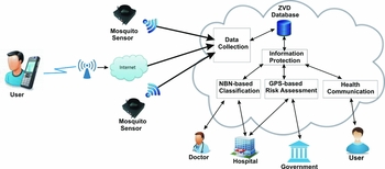
In this section, we detail the proposed system and operating assumptions. The architecture of the proposed system for the detection and monitoring of the spread of ZikaV is shown in Figure 1.
An architecture of the proposed system.

Data Collection Component
The data collection component enables the users to use their mobile phones to enter their personal information and information about ZVD symptoms. Initially, each user is registered with the system by entering his personal details through an Android application installed on the user's mobile phone. Each registered user is provided with a reference number (RN) automatically generated by the system. Once the user is registered with the system, the ZVD related symptoms are collected periodically through the user's mobile phone. The presence or absence of the symptoms of a user is coded as “Y” or “N”.
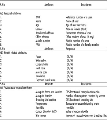
The information about high mosquito-dense areas and mosquito breeding sites is captured continuously through wireless mosquito sensors, which are placed at different locations of a risk-prone area. It also measures air temperature, humidity, and carbon dioxide values around standing water, which can be used to evaluate the conditions under which the mosquitoes may lay eggs. Such information is further transmitted to the cloud server and stored in the database for further processing. In certain remote areas, where sensors are not deployed, the users can also enter the details of mosquito-dense and breeding sites along with images taken by the camera of the mobile phone, if they come across these spots using the mobile application. The doctors, hospitals, and government healthcare departments have access to the information, and they can also view this information to plan the required preventive actions. Table 1 shows the attributes of personal information, ZVD symptoms, and the environmental attributes of mosquito-dense sites and breeding sites.
Personal, Health, and Environmental Attributes of Users

Information Protection
The personal and health details of a user stored in the cloud need to be kept confidential. It may contain attributes whose associations or attribute itself are sensitive and should not be visible to everyone. Such information, if visible to others may create panic situations among people. The proposed system incorporates fragmentation and a secret sharing mechanism in a two-stage process to protect the privacy of data. The user data are first divided into multiple fragments so as to satisfy the confidentiality constraints. In the second stage, a secret sharing scheme is applied to the sensitive attribute itself that splits the value of the sensitive attribute into secret shares (Reference Sareen, Sood and Gupta18).
Definition 1: A data table D having a set of attributes (a 1, a 2, . . ., an ) of a patient sent to the cloud using the mobile application at the time of registration and CA is a set of association constraints. To correctly fragment the data table, the following conditions should be met:
 $$\begin{equation*}
\begin{array}{@{}*{1}{l}@{}} {\forall c \in {C_A},{f_i} \subseteq D,c \not\subset {f_i}}\\[3pt] {{f_1}U{f_2}U.....U{f_n} = D}\\[3pt] {{f_i} \cap {f_j} = \emptyset ,i \ne j,\forall {f_i},{f_j} \in F} \end{array}
\end{equation*}$$
Definition 2: A data table D may contain a sensitive attribute as that should be protected from other users. The threshold secret sharing scheme is applied that distribute the values of a sensitive attribute into n pieces v 1, v 2, . . ., vn and store at different cloud servers. Choose at random k − 1 coefficients a 1, a 2, . . ., a k − 1 and let the secret value as be assigned to the coefficient a 0. The random polynomial of degree (k − 1) becomes
 $$\begin{equation}
f(x) = {a_0} + {a_1}x + {a_2}{x^2} + ...... + {a_{k - 1}}{x^{k - 1}}
\end{equation}$$
Choose secret key pieces X(x 1, x 2, . . ., xn ) which are a set of n randomly chosen points corresponding to each cloud server (CS). Thus, the system computes the share of each CSi by substituting the value of xi ∈ X and values of the coefficients a 1, a 2, . . ., a k − 1 (randomly chosen) in Equation [1] as f(xi ) and sends it to the CSi . To reconstruct the value of the sensitive attribute from the secret shares, any set of k cloud servers will be enough to retrieve the shares they received. Because the secret points x 1, x 2, . . ., x k − 1 is not known to any of the cloud servers and is only kept with trusted server, thus only the trusted server can reconstruct the secret value after retrieving at least k shares from any k of the cloud servers. Using k points from the set X and the values of f(xi ), construct k points (xi , f(xi )) where i = 1, 2, . . ., k. Given any set of k pairs, we can find the coefficients of the polynomial by using Newtons’ divided difference interpolation and then evaluate as = a 0, which is the original value of the sensitive attribute.
NBN-Based Classification
This component provides an initial diagnosis to users by classifying them depending upon their ZVD attributes values, respectively, using NBN classifier (Reference John and Langley19) as category I (Infected) and U (uninfected). NBN classifier is a powerful probabilistic model for solving classification problems in a variety of domains. In this model, all predictor variables X 1, X 2, . . ., Xn are conditionally independent given a single class variable C. Because all the symptoms of ZVD are independent of each other, NBN is proposed to classify the users as Infected (I) or Uninfected (U). The probability parameters are estimated from the training dataset using maximum likelihood estimator.
Let C be a class variable representing two categories Uninfected (U) and Infected (I) based on a vector of symptoms Si = (F, SR, C, JP, MP, H, ERA). To classify a user xi ∈ X, i = 1, 2, . . ., n into infected (I) or uninfected (U) using his symptoms Si , the probability of each class is computed using the Bayes’ rule as given below:
 $$\begin{equation*}
\begin{array}{@{}*{1}{l}@{}} {P(C = U|{S_i}) = \frac{{P(U)P({S_i}|U)}}{{P({S_i})}}}\\[4pt] {P(C = I|{S_i}) = \frac{{P(I)P({S_i}|I)}}{{P({S_i})}}} \end{array}
\end{equation*}$$
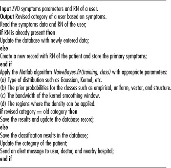
where P(C = U|Si ) represents the probability of any user as uninfected (U) based on his symptom Si , P(C = I|Si ) is the probability of any user as infected (I) with ZikaV based on his symptom Si , P(U), and P(I) are the probability of having ZikaV infection and P(Si ) is the probability of having a symptom Si . The category of a user is identified by comparing the probabilities of two categories. The class with a higher probability will be the category of the user. Algorithm 1 is designed to evaluate the category of the user using NBN classification algorithm. In this algorithm, the vital symptoms entered by the users from their respective mobile phones are used along with their reference numbers. A Matlab algorithm NaiveBayes.fit is applied with appropriate parameters.
Evaluate the Category of the Patient Using NBN

Global Positioning System-Based Risk Assessment
ZikaV is primarily spread by mosquitoes, which transmit the virus into the human blood through a bite. The virus replicates in the blood and is picked up by other mosquitoes that bite and inject into other persons. The objective of this component is to provide the information related to the identification of mosquito-dense sites, breeding sites, and infected population in real time to strengthen the efforts of the public healthcare agencies. Such information might be difficult to identify by the healthcare authorities.
The geographic location of infected users, breeding sites, and sites with high mosquito density can be used to identify and separate the risk-prone areas. Identification and eradication of mosquito-dense and breeding sites is a vital step to contain the source of ZikaV. Once the risk-prone area is identified, the spread of infection can be controlled by sending alert messages and infection-control suggestions to the people residing in those areas. The infected users are continuously diagnosed and monitored until they are completely recovered from the infection. The cloud server is engaged in continuously capturing the data from users as well as mosquito sensors so that any newly infected user or risk-prone site is automatically identified.
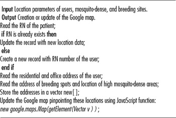
Google Maps (20) Web service is used to visualize the spread of infection, high mosquito-dense sites, and breeding sites using their global positioning system (GPS) locations. The probability of ZikaV infection is very high at the residence and workplace, breeding sites, and sites with high mosquito density so these locations are used to identify risk-prone areas and infected users. The representation of risk-prone areas over Google Maps helps the government healthcare departments and uninfected users to control the epidemic. The locations of new infected users and sites are automatically detected by the system and the Google map is updated accordingly. Algorithm 2 is designed to show the exact location of the infected users, breeding sites, and mosquito-dense sites, which are dynamic and adaptive in nature. The JavaScript class Map is used to create an instance of this class that represents a single map. A vector that stores RN, latitude, and altitude values of infected user's home and workplace, mosquito-dense areas, and mosquito breeding sites is passed to the object of the class Map.
Creation/Update of Google Map

Health Communication Component
This component is used for controlling the spread of ZikaV outbreak, which is one of the important steps in our proposed system. System generated health education and alert messages related to (a) preventing the growth of mosquitoes, and (b) preventing the bites of mosquitoes are sent to the infected or uninfected users through SMS or e-mail inboxes to improve the user's health preventive behavior in Zika-endemic areas. It can be a warning, reminders, or any suggestions sent repetitively to improve knowledge of preventive measures among users which may lead to reductions in Zika infestation risk. These informational campaigns motivate the users for the adoption of preventive measures against the disease. Alert messages are also sent to nearby hospitals or healthcare agencies depending upon the GPS location of the patient's mobile phone.
Operating Assumptions
In our proposed system, we made the following assumptions for its successful operations: (i) The WiFi internet facility 3G/4G is expected to be available in a region under observation. (ii) The communication bandwidth of the network should be high to process the patient's data in real time. (iii) The cloud-based service is assumed to be available in those risk-prone areas. (iv) The mobile phones of the patients play a vital role in our proposed system. Thus, each patient should carry a mobile phone. (v) For the accurate classification of the users infected with ZikaV, the information related to user's symptoms needs to combine with the information about mosquito-dense areas and mosquito breeding sites. Thus, mosquito sensors are expected to install at different locations of a risk-prone area. (vi) The users monitoring for ZikaV will not travel to other regions, otherwise, false positive rate of the proposed system will increase.
EXPERIMENT SETUP AND PERFORMANCE ANALYSIS
To evaluate the performance and effectiveness of our proposed system, different experiments were conducted. The experiment is divided into following segments: (i) Synthetic data generation; (ii) Training and testing of NBN; (iii) Risk assessment using Google Maps; (iv) Economic feasibility analysis.
Synthetic Data Generation
A thorough search has been made on the Internet for the symptoms-based data for ZikaV infected patients for the testing of the proposed system. Because symptoms-based data for ZVD patients is not available, synthetic data are generated in such a way that all possible combination of symptoms is considered. In our proposed system, seven different ZikaV attributes are used to diagnose any user for infection. A real dataset of around 2 million people containing personal and demographic information is obtained from census data (21). A dataset containing the location of breeding sites as well as mosquito-dense sites are synthetically generated. All possible combinations of ZikaV symptoms are randomly mapped with 2 million user data.
Training and Testing of NBN
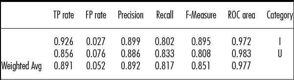
NBN classifier is used for the categorization of users into uninfected and infected categories using the generated synthetic data. The “bnlearn” package of the R-Studio is used to create a Bayesian network using the data of 50,000 users. The results show that the algorithm “hc” perform better because of their higher number of directed arcs. In our experiment, “hc” algorithm has been used to train the network. Trained NBN is tested in Weka 3.6 (Reference Hall, Frank, Holmes, Pfahringer, Reutemann and Witten22). A 10-fold cross validation is applied to evaluate the performance of the NBN. Table 2 shows the detailed accuracy of each category classified by the NBN classifier. NBN classifies the users with an accuracy of 89 percent.
Category Wise Detailed Accuracy for NBN in Weka 3.6

True positives (TP), also known as sensitivity, are the percentage of categories of ZVD cases correctly classified by the classifier. False positives (FP), also known specificity, are the percentage of ZVD cases wrongly classified by the classifier (Reference Baldi, Brunak, Chauvin, Andersen and Nielsen23). The Naive Bayesian algorithm produces high TP rate of 0.891 and low FP rate of 0.052. The relevancy of the results is provided by the two parameters precision and recall. The proposed classification algorithm provides higher values of precision and recall, which are 0.892 and 0.817, respectively. The other statistical parameters F-Measure and ROC area both represents classification accuracy (Reference Baldi, Brunak, Chauvin, Andersen and Nielsen23). An algorithm with a higher value of F-Measure and ROC area are more accurate and our NBN classifier provides F-Measure of 0.851 and ROC area of 0.977, respectively. Hence, the use of the NBN classifier in our proposed architecture is justified.
Risk Assessment Using Google Map
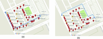
To evaluate the GPS-based risk assessment, data related to infected users, breeding sites, and mosquito-dense sites are generated over the Amritsar city in India. Three files in the .csv format containing the details of 5,000 users, breeding sites, and mosquito-dense sites are fed to the Google map using the Google API in JavaScript. Figure 2a shows the location of possible infected users, breeding sites, and mosquito-dense sites. The figure also shows the routing of a user from location A that is D-322, Defence Colony, D-Block, Ranjit Avenue, Amritsar, Punjab 143001, India, to location B that is D-584, Hotel HK Intercontinental, Defence Colony, D-Block, Ranjit Avenue, Amritsar, Punjab 143001, India, without implementing any re-routing algorithm. Here, the user passes through the mosquito breeding sites and mosquito-dense sites, which increase the risk of catching the ZikaV infection. Alternatively, the user has diverted to the safer path by using an appropriate re-routing as shown in Figure 2b. The blue line shows the normal and proposed route by Google services.
GPS-based re-routing of a user from location A that is D-322, Defence Colony, D-Block, Ranjit Avenue, Amritsar, Punjab 143001, India, to location B that is D-584, Hotel HK Intercontinental, Defence Colony, D-Block, Ranjit Avenue, Amritsar, Punjab 143001, India. (A) Default routing of user using Google services. (B) Safe routing of a user based on infected areas.

Economic Feasibility Analysis
Cost is an important factor that needs consideration to evaluate the economic feasibility of our proposed system in poor countries. Using cloud services is a fundamentally different approach in which no maintenance or installation is required, and the upfront cost can be eliminated entirely by using a pay-per-use payment method that charges the user by rounding up to the nearest hour of usage time. Let's take an example of Amazon Web Service (AWS), a cost-effective Web service that offers three usage tiers: on-demand, 1-year reserved, and 3-year reserved. To substantiate, Amazon offers EC2 service for virtual computer rental (known as instances) with a variety of hardware specifications. The most basic instance is a single-core CPU with 1 Gbyte of RAM, priced at US $0.013 per hour (24). The cost of mosquito sensors have fallen significantly over the past few years, which is built from inexpensive commodity electronics, captures insect flight information using laser light, and classifies the insects according to their species. The analysis shows that the cloud computing services and sensor technology are cost-effective and can be useful in deploying our proposed system to control the ZikaV outbreak in low socio-economic area.
CONCLUSIONS
Among many public health alerts, the global spread of ZikaV is of concern and alarm. In this study, we have presented a cloud-based system for detecting and controlling the ZikaV using a mobile device and IoT. NBN is used to diagnose the users as infected or uninfected using their symptoms. Mosquito sensors are deployed in different sites to obtain the information about mosquito-dense sites and environmental parameters to discover the breeding sites. GPS is used to display ZikaV infected users, mosquito-dense sites, and breeding sites on Google Maps. Using Google Maps, uninfected users can be re-routed to protect them from the risk-prone areas. Our proposed system provides 89 percent accuracy in classification and accurate identification of risk-prone areas. It will help the government healthcare departments to control the mosquito population more effectively.
The developed framework can be used as an intelligent system for the detection and prevention of ZikaV outbreak, which can support a large number of patients simultaneously across the globe. It provides remote continuous monitoring of ZikaV infected patients and also keeps track of virus transmission that can be used to prevent its spread. It will also assist government healthcare centers and hospitals to promptly intervene in the case of emergency situation.
CONFLICTS OF INTEREST
No conflicts of interest.