INTRODUCTION
Atmospheric testing of thermonuclear devices in the 1950s and 1960s produced a global radiocarbon signal that can be traced in the mixed layers of all world oceans. While numerous studies have documented the diffusion of atmospheric bomb 14C into the surface ocean through direct measurements of dissolved inorganic carbon (DIC) in seawater (e.g. Nydal and Gislefoss Reference Nydal and Gislefoss1996; Stuiver et al. Reference Stuiver, Ostlund, Key and Reimer1996), some of the most comprehensive regional records have come from the uptake of 14C into hermatypic corals inhabiting tropical and subtropical seas (e.g. Guilderson et al. Reference Guilderson, Schrag, Kashgarian and Southon1998; Fallon and Guilderson Reference Fallon and Guilderson2008). Uses of these seawater and coral records, typically reported as ∆14C with reference to a pre-nuclear standard (Stuiver and Polach Reference Stuiver and Polach1977), range from modeling air-sea diffusion and oceanic ventilation (Bien et al. Reference Bien, Rakestraw and Suess1965; Druffel Reference Druffel1987; Druffel et al. Reference Druffel, Williams, Robertson, Griffin, Jull, Donahue, Toolin and Linick1989; Rodgers et al. Reference Rodgers, Schrag, Cane and Naik2000; Kumamoto et al. Reference Kumamoto, Murata, Kawano, Watanabe and Fukasawa2013) to providing a temporal reference for determining the age of fishes and other marine organisms with calcified structures that are conserved through time (Kalish Reference Kalish1993; Baker and Wilson Reference Baker and Wilson2001; Fallon and Guilderson Reference Fallon and Guilderson2005; Andrews et al. Reference Andrews, Kalish, Newman and Johnston2011; Darrenougue et al. Reference Darrenougue, De Deckker, Payri, Eggins and Fallon2013).
Early ∆14C records from corals provided general trends describing the arrival (onset), peak, and decline of bomb-produced 14C by sampling either annually or once every few years (Druffel Reference Druffel2002), with a few limited exceptions that also explored subannual variation (e.g. Druffel Reference Druffel1987). Because technological advances have increased instrument precision for smaller sample masses, a higher temporal resolution is now possible. In particular, using accelerator mass spectrometry (AMS) to measure 14C in hermatypic corals has led to complete bomb 14C records with subannual resolution (e.g. Guilderson et al. Reference Guilderson, Schrag, Kashgarian and Southon1998; Fallon and Guilderson Reference Fallon and Guilderson2008) that provide opportunities to observe both seasonal variations and possible differences in the bomb 14C signal characteristics within and between regions.
In the tropical Pacific Ocean, numerous ∆14C records from hermatypic corals have been described to date, but many of them have either low temporal resolution or are incomplete in covering the full uptake and decline of the bomb 14C signal (Grottoli and Eakin Reference Grottoli and Eakin2007). For the Hawaiian Archipelago, several studies have documented segments of the bomb 14C record (Druffel Reference Druffel1987; Druffel et al. Reference Druffel, Griffin, Guilderson, Kashgarian, Southon and Schrag2001; Roark et al. Reference Roark, Guilderson, Dunbar and Ingram2006), but a complete and validated time series representing sea-surface 14C levels from pre-bomb to the post-peak decline remains unestablished.
By spanning the geometric center of the North Pacific, coral reefs of the Hawaiian Archipelago are ideally placed to record uptake of the bomb 14C signal in the North Pacific Gyre (NPG). A partial view of the behavior of the bomb 14C signal in the NPG has come from a few studies from corals of French Frigate Shoals (FFS) and Kona, Hawaii Island (Druffel Reference Druffel1987; Druffel et al. Reference Druffel, Griffin, Guilderson, Kashgarian, Southon and Schrag2001), and by instantaneous measurements of DIC in seawater from research cruises transiting the Pacific Ocean over several decades (Linick Reference Linick1975; Ostlund and Stuiver Reference Ostlund and Stuiver1980; Key Reference Key1996; Stuiver et al. Reference Stuiver, Ostlund, Key and Reimer1996; Kumamoto et al. Reference Kumamoto, Murata, Kawano, Watanabe and Fukasawa2013). While recent compilations of these data have recovered more details about the conservation and dissipation of the bomb 14C signal in the NPG (Druffel et al. Reference Druffel, Bauer, Griffin, Beaupre and Hwang2008; Kumamoto et al. Reference Kumamoto, Murata, Kawano, Watanabe and Fukasawa2013), a longer and higher resolution 14C chronology from a single site would provide a comprehensive ∆14C record suitable for calibrating shorter or individual records from the NPG.
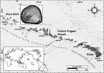
Kure Atoll is a circular atoll with an almost continuous reef crest encircling a relatively shallow lagoon at the northern end of the northwestern Hawaiian Islands (Figure 1; 28°25.28′N, 178°19.55′W). As the world’s most northerly atoll, it represents the Darwin Point, defined as the latitudinal threshold for the cooler waters of the subtropical North Pacific where the rate of calcium carbonate deposition by reef builders equals the combined rates of subsidence and erosion (Dana Reference Dana1971; Grigg Reference Grigg1982). A coral core was extracted in 2002 from the western back-reef of Kure Atoll and analyses of growth bands suggested that the core represents continuous growth dating back to the pre-bomb period (Siciliano Reference Siciliano2005). The counts of growth bands assumed a well-developed continuous pattern of annual density bands, but validation of this time series was lacking. The primary goal of this study was to validate the time series by using Sr/Ca ratios as a proxy for annual temperature changes in the Kure Atoll environment, and then use this validated bomb 14C chronology to establish the Kure Atoll coral core as a high-resolution ∆14C reference record for the northwestern Hawaiian Islands (NWHI) and the NPG.
Map of the Hawaiian Archipelago with the northwestern Hawaiian Islands (NWHI) and main Hawaiian Islands (MHI) labeled. The locations of coral core ∆14C records were from Kure Atoll (inset), French Frigate Shoals, and Kona, Hawaii Island. The inset satellite image of Kure Atoll shows the location of the coral core extraction on the western back reef, close to the open ocean passage to the southwest. Other labeled locations correspond to fish otolith samples used in this study to investigate ∆14C levels across the archipelago. Emergent islands of the MHI are darker than seamount reefs (light gray) of the NWHI. Base bathymetric map was sourced and modified from Pacific Islands Benthic Habitat Mapping Center, School of Ocean and Earth Science and Technology, University of Hawaii at Manoa.

The second objective of this study was to use the Kure Atoll record, in concert with other ∆14C records (otoliths and DIC), to establish a complete ∆14C timeline for the Hawaiian Archipelago that can provide a basis for determining the ages of marine organisms, such as regional reef fishes and deep-water snapper and grouper. The first successful application of bomb 14C dating as an age validation method in this region was with the pink Hawaiian snapper (Pristipomoides filamentosus; Andrews et al. Reference Andrews, DeMartini, Brodziak, Nichols and Humphreys2012). Age for this species was validated to over 40 yr by aligning otolith ∆14C measurements in birth year material with the ∆14C rise period (~1955–1970) referenced in existing coral records. However, because the coral reference was a mix of fragmentary or unvalidated coral ∆14C records (Druffel Reference Druffel1987; Druffel et al. Reference Druffel, Griffin, Guilderson, Kashgarian, Southon and Schrag2001; Roark et al. Reference Roark, Guilderson, Dunbar and Ingram2006), some assumptions about the accuracy of birth year assignment and corresponding age were necessary. It is also possible that bomb 14C dating can be expanded to the post-peak ∆14C decline period, making it possible to age younger and more recently collected fish (age of less than ~20–30 yr). This approach was successful for younger speckled hind (Epinephelus drummondhayi) in the Gulf of Mexico and this novel method was validated with known-age, juvenile fish from recent and archived collections (Andrews et al. Reference Andrews, Barnett, Allman, Moyer and Trowbridge2013). The present study evaluates the hypothesis that the same approach would work for the ∆14C record at Kure Atoll and for fishes of the NWHI.
MATERIALS AND METHODS
Coral Core and Microsampling
A vertical core was taken from near the top of a large, living Porites evermanni colony located on the western back reef of Kure Atoll on 25 September 2002 (Figure 1). The coral was ~3 m in diameter and ~1.7 m high in water ~2 m deep. This location was expected to be free of lagoon effects because of its close proximity to the open ocean via passages to the southwest. The core was extracted close to the maximal growth axis with a corer that consisted of a 50-cm-long hollow steel cylinder with a circular hole saw welded on the cutting end. The corer was mounted in a 3/8-inch (9.5-mm) pneumatic drill powered with compressed air from SCUBA tanks. The extracted core was 5 cm in diameter, 50 cm long, and in 5 pieces due to fracturing while coring. All pieces of the core were sectioned longitudinally with a rock saw in slabs 5 mm thick. The slabs were cleaned by sonication in deionized water, dried, X-rayed, and consecutive pairs of high- and low-density bands were used to establish a time series for the core (Siciliano Reference Siciliano2005). The original estimated timespan based on band-pair counts covered the years 1939 to 2002.
Before extracting samples from the coral slab for Sr/Ca and 14C measurements, each of the five sections was sonicated three times in a Branson 2510 sonicator in Milli-Q water for 5 min, with thorough rinsing between sonication, and then air-dried in a clean, positive-pressure, laminar flow hood. The extraction surface faced downward during sonication to allow loose coral fragments and dust to vibrate free of the coral matrix.
Samples for use in validating the coral core time series and for the 14C measurements were extracted with a New Wave Research® (ESI-NWR Division; Fremont, CA) micromilling machine using a 1.0-mm Brasseler® (Savannah, GA) bur. Four samples were extracted from each year with equal spacing within the density band pairs (absolute spacing dependent on full band-pair width). Extractions consisted of paths cut into the coral matrix running perpendicular to the growth axis. Hence, sampling was more tightly spaced where slower growth was manifested as narrow bands and vice versa. Collection of the powdered sample was carefully performed with a fine-tipped probe. Because tapping on the sample released fragments from other parts of the coral core, this was avoided to prevent inadvertent collection of extraneous coral material. Samples were stored in clean cryovials (Wheaton® USA, 1.2 mL).
An equally spaced sample design was accomplished by running an initial set of samples covering the 62 yr of growth. Initial annual or biannual sampling was performed on 42 of the 62 yr, all of which were selected based on the X-ray density banding for a consistent seasonal formation period (i.e. all initial extractions were winter growth). This initial sample set was used to confirm that a bomb 14C signal was present and apparently uncompromised in the coral core. The remainder of the sample series was extracted using the micromilling interpolation routine, with either 3 or 7 equally spaced extractions between each of the initial annual or biannual extractions, respectively. The extraction routine was typically 3 to 4 overlapping scans at 5–8 mm in length and at a depth of 333–400 µm (less than half the bur diameter) for each surface scan or path. Each sample was partitioned into two parts for (1) measurement of Sr/Ca ratios with optical emission mass spectrometry (OES), and (2) measurement of 14C/12C and 13C/12C using accelerator mass spectrometry (AMS) for determination of ∆14C with a separate δ13C measurement from a gas-partitioned sample. The sample mass available from individual extractions was typically ~1–3 mg for OES and ~4–6 mg for AMS.
Sr/Ca Measurements
Molar ratios of Sr/Ca from the coral samples were determined by inductively coupled plasma optical emission spectroscopy on a Perkin Elmer 4300DV (ICP-OES) using previously described procedures (Wara et al. Reference Wara, Anderson, Schellenberg, Franks, Ravelo and Delaney2003) with the following minor changes. Each 1–3 mg sample was dissolved and diluted in a sufficient amount of 1% (0.14N) HNO3 to give Ca concentrations of 50–100 µg mL–1. Stock standards were prepared gravimetrically from Spex Certified solutions at nominal Sr/Ca ratios of 8, 9, and 10 mM·M–1 (millimoles per mole). These stock standards were diluted with 1% HNO3 to Ca concentrations of 25, 50, and 100 µg·mL–1 and then used to create a calibration curve of [Sr 407]/[Ca 317] wavelength intensity versus Sr/Ca mM·M–1. Reference material (JCp-1, Geological Survey of Japan) was used as an accuracy check and run at Ca concentrations of 40 and 70 µg·mL–1. An in-house, quality control standard (QC) made from a homogeneous Porites sp. coral (collected in Papua New Guinea in 1994) was used to estimate within- and between-run precision (generally <0.1% and <0.3%, respectively). Each analytical run consisted of blanks and standards (0, 25, 50, and 100 µg·mL–1 Ca at 8, 9, and 10 mM·M–1 [Sr]/[Ca]), followed by the QC samples, and then blocks consisting of 10 samples, blank, and quality control samples. The standards were run again at the end of each analytical run.
Measured Sr/Ca ratios were not used to estimate temperature because of the coarseness of sampling (each extraction was potentially 1–3 months of skeletal growth). Instead, the peaks and valleys were used to validate the interpretation of the annual banding pattern based on the known annual temperature range of ~19o–27°C at Kure Atoll (Dana Reference Dana1971; Desch et al. Reference Desch, Wynne, Brainard, Friedlander and Christensen2009). Sample dates of deposition were assigned to each high and low point of the Sr/Ca cycle, corresponding to the coolest and warmest seasons, respectively (Desch et al. Reference Desch, Wynne, Brainard, Friedlander and Christensen2009). The low values were assumed to have been deposited in January–March, the coolest months at Kure Atoll, and were assigned a date (in decimal years) as the start of each year (e.g. 1954.00). July–September is the warmest period at Kure Atoll and samples with high values were assigned as the half-year (e.g. 1954.50). Most samples between these points were assigned to intermediate dates (either April–June=1954.25 or October–December=1954.75). In some cases, offsets in the sample spacing relative to the Sr/Ca highs and lows led to other proportional annual fractions (e.g. 1968.33 and 1975.20).
Fish Otoliths
Otolith samples used as ∆14C references in this study were selected opportunistically and based on their collection dates from various research cruise archives and recent collections in an attempt to cover as much of the bomb 14C period as possible. There were fortuitous, albeit very limited, otolith collections for pink Hawaiian snapper (Pristipomoides filamentosus) and Hawaiian grouper (Hyporthodus quernus), both of which are regional species of interest for age and growth studies. For each species, otolith specimen collections spanned approximately 40 yr and ranged from the late 1970s to 2008 (Table 1a b).
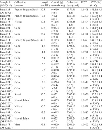
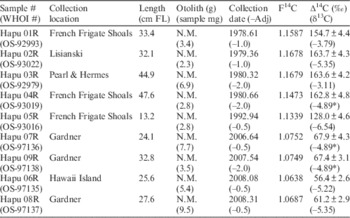
Otoliths were analyzed from 20 pink Hawaiian snapper and 9 Hawaiian grouper collected from nearly the entire length of the Hawaiian Archipelago, ranging from Pearl and Hermes Atoll in the northwest to Hawaii Island in the southeast (Figure 1). Fish ranged from recently settled recruits in their first year of growth [lengths from ~9 cm fork length (FL) for snapper and 13 cm total length (TL) for grouper], to fish estimated to be several years old with lengths near 40 cm FL for snapper and 50 cm TL for grouper (Table 1a,b). Whole otolith weights for pink Hawaiian snapper ranged from 0.0090 to 0.1216 g and samples of 4.1 to 15.1 mg were chipped off for 14C analysis via AMS. Whole otolith weights for Hawaiian grouper were not measured and sample weights chipped off for 14C analysis ranged from 2.3 to 9.5 mg.
Reference ∆14C data from otoliths of 20 pink Hawaiian snapper (Pristipomoides filamentosus) of known collection date and locality in the Hawaiian Archipelago. Each sample analyzed was either part of a whole otolith from smaller fish or otolith edge material from larger fish. Whole otolith and sample weights are provided with collection date and the adjustment necessary (–Adj=years) to compensate for estimated period of formation.

* Mean δ13C value for all measured values.
N.M.=Not measured.
Reference ∆14C data from otoliths of 9 Hawaiian grouper (Hyporthodus quernus) of known collection date and locality in the Hawaiian Archipelago. Each sample analyzed was either part of a whole otolith from smaller fish or otolith edge material from larger fish. Whole otolith and sample weights are provided with collection date and the adjustment necessary (–Adj=years) to compensate for estimated period of formation.

* Mean δ13C value for all measured values.
N.M.=not measured.
Each fish otolith was sampled on the outer portion for known collection date material. The potential period of formation that was sampled required an adjustment for the period of growth sampled. The smallest fish were sampled by breaking off part of the whole otolith because the potential age was only 1 to 2 yr. Larger fish were sampled more carefully by breaking off the leading edge containing what was estimated as the most recent growth. Larger fish were estimated to be ~4 to 6 yr old, but the outer part of the otolith sampled probably consisted of 2 to 4 yr of growth (in the worst case scenario), leading to a temporal shift of the estimated date of formation for the measured ∆14C value by 0.5–2 yr (mean period of formation) from the known collection date (Table 1a,b).
14C and 13C Measurements
The powder (coral) and small chip (otolith) samples were submitted as carbonate to the National Ocean Sciences Accelerator Mass Spectrometry Facility (NOSAMS), Woods Hole Oceanographic Institution (WHOI) in Woods Hole, Massachusetts, for routine 14C analysis using AMS. 14C measurements were reported by NOSAMS as fraction modern (F14C; Reimer et al. Reference Reimer, Brown and Reimer2004) after correction for fractionation using measured δ13C. For coral samples, δ13C values are online AMS data. Meanwhile, for otolith samples δ13C values from an isotope ratio mass spectrometer were used for the fractionation correction because the analyses predated the online AMS correction. These F14C values were used to calculate age-corrected ∆14C (Stuiver and Polach Reference Stuiver and Polach1977) using validated date of coral formation or otolith collection for direct comparison with numerous other ∆14C records.
Other ∆14C Records
The ∆14C values from the Kure Atoll coral core were compared with several other ∆14C records from corals of the Hawaiian Archipelago and from various mixed layer DIC measurements of the NPG. Because the Hawaiian Archipelago covers a wide cross-section of the NPG, it was necessary to qualify some of the findings with reference to observed and unknown variability of current structure and 14C uptake via air-sea gas exchange. In general, a region of latitude and longitude that enclosed the Hawaiian Archipelago was chosen for an analysis of existing DIC ∆14C measurements relative to the amplitude and temporal variability of the Hawaiian Archipelago coral records. These stations covered latitudes ~15°N to ~35°N and longitudes ~180°W to ~150°W, a region of mixed surface waters representing potential sources of DIC to corals of the Hawaiian Archipelago. Locations north of 35°N were not considered because they would begin to enter the North Pacific Current, a transition zone that borders the Subpolar Gyre and has lower ∆14C values (Broecker and Peng Reference Broecker and Peng1982; Broecker et al. Reference Broecker, Peng, Ostlund and Stuiver1985; Kumamoto et al. Reference Kumamoto, Murata, Kawano, Watanabe and Fukasawa2013). A similar situation prevails for any survey location south of 15°N where the influence of the North Equatorial Current (NEC) also elicits a reduced 14C signal due to either high CO2 saturation states or some degree of upwelling, or both (Broecker and Peng Reference Broecker and Peng1982; Broecker et al. Reference Broecker, Peng, Ostlund and Stuiver1985). Other coral ∆14C records from the Hawaiian Archipelago and Japan covered variable timespans or were digitally rendered from the original published figure [Figure 1 from Konishi et al. (Reference Konishi, Tanaka and Sakanoue1982); Figure 8 from Roark et al. (Reference Roark, Guilderson, Dunbar and Ingram2006)] using Plot Digitizer v 2.5.1 (Huwaldt Reference Huwaldt2011). All of these ∆14C records were compared qualitatively and quantitatively for conformity or disagreement with the Kure Atoll coral and fish otolith ∆14C records.
RESULTS AND DISCUSSION
Kure Coral Calibration and ∆14C Characteristics
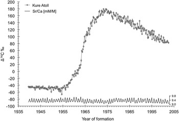
The annual periodicity of each density band pair was confirmed with a range of Sr/Ca values that cycled in a regular pattern from ~9.0 to ~9.8 mM·M–1. The period that was continuously sampled covered 1939.50 to the time when the living coral core was collected in 2002.50. The oscillating Sr/Ca pattern correlated with the original date estimates from density band counting in coral core X-rays (Siciliano Reference Siciliano2005). This provided a validated timeline to establish a temporal context to the 14C measurements from the same sample series (Figure 2). No attempt was made to estimate temperature from these measurements because of the sampling coarseness that included up to 3 months of skeletal growth in each measurement.
Coral ∆14C record from Kure Atoll with the measured Sr/Ca ratios used to validate the annual-band time series. Both ∆14C and Sr/Ca measurements were performed on each sample at a frequency of four sample extractions per year (n=252). The complete coral time series was validated with the annual periodicity of the measured Sr/Ca ratios as a proxy for annual temperature change.

The sample series exhibited the expected bomb 14C signal by starting with pre-bomb levels in the 1940s, rising to a peak through the mid-1950s and 1960s, and entering a period of decline in the mid-1970s (Figure 2). Of the 252 samples extracted from the coral core for 14C and 13C analyses, one (K182) was lost during AMS sample processing, leaving a total of 251 samples and covering a fraction of a year earlier than originally targeted (1939–2002; Appendix I in Online Supplementary Material). The ∆14C values determined from these measurements ranged from a pre-bomb minimum of –66.0‰ in the summer of 1954 to a series of peak values near 180‰ in 1973 and 1974 (Figure 2; Appendix I in Online Supplementary Material). Mean pre-bomb was –48.2±4.2‰ from 1939 to 1955, after which the ∆14C rise began. The most rapid increase was over a period of 2 yr at a rate of 45‰ per year (1962.75–1964.75) and a change of 191‰ in just 10 yr (1958–1968). The maximum overall increase was 245‰ over approximately 20 yr and the increase from mean pre-bomb to mean peak values was ~220‰ in 16 yr (~1956 to 1974). This rapid ∆14C increase was similar to other coral ∆14C records off Japan and in the Gulf of Mexico (Grottoli and Eakin Reference Grottoli and Eakin2007).
The peak ∆14C period for the Kure coral was relatively short compared to most coral records of the world oceans and can be defined in two ways: (1) as a short period of ~2 yr (1973–1974) during which maximum values were maintained at a mean of 175.3±4.0‰; and (2) as a longer period of ~6 yr (1971–1976) of elevated values beginning after most of the rise and ending before a substantial decline. This extended peak period maintained a ∆14C mean of 170.6±5.0‰. After the peak period, ∆14C levels tapered off more slowly and irregularly into the prolonged post-peak decline, a period of interest in the age determination of fishes less than 30 yr old. The decline appears to begin after a sharp disruption in the peak cycle in 1977 (Figure 2). From 1978, the ∆14C series decreased monotonically for 25 yr to ~82‰ at a decline rate of ~3.4‰ per year (n=97, y=–3.38x+6856, R 2=0.923). This rate of ∆14C decline is greater than what was documented for the Gulf of Mexico (GoM). Using regional coral and otolith ∆14C records throughout the GoM, a decline rate of ~2.6‰ per year was documented over a similar period and was useful in providing validated age estimates for younger fish specimens (Andrews et al. Reference Andrews, Barnett, Allman, Moyer and Trowbridge2013).
Coral ∆14C Records of the Hawaiian Archipelago
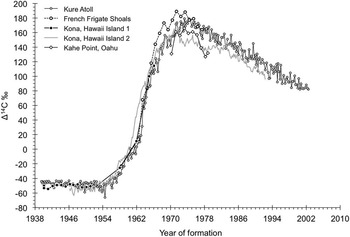
Other coral ∆14C records from the Hawaiian Archipelago agree closely with the Kure Atoll coral record for the pre-bomb and the earliest rise period, with some notable departures mid-rise and during the peak and decline periods (Figure 3). A 20-yr record from FFS rises at a similar rate before reaching slightly greater peak values (180–190‰) in 1971–1973 (Druffel et al. Reference Druffel, Williams, Robertson, Griffin, Jull, Donahue, Toolin and Linick1989), about 2 yr earlier than the Kure Atoll maximum (1973–1974). Maximum values above 170‰ persist in the FFS record for approximately 8 yr (1968–1976). While the FFS record shows a generally similar ∆14C arrival and elevated bomb 14C signal, the post-peak decline is limited and ends in 1978—a time when the ∆14C value of 165‰ is in agreement with the Kure Atoll record (~160–168‰). The FFS record begins during the ∆14C rise in 1958; no pre-bomb records exist for this region of the NWHI. However, a pre-bomb ∆14C record is available from Kona on Hawaii Island (Kona, Hawaii Island 1; Figure 3), at the opposite end of the Hawaiian Archipelago (Druffel et al. Reference Druffel, Griffin, Guilderson, Kashgarian, Southon and Schrag2001). Although that record was used primarily for a study of pre-bomb oceanography, a series of four data points on the ∆14C rise provides evidence for a rapid 14C increase that was similar to the Kure Atoll record in timing and rate of rise up to the last sample in 1966.
Kure Atoll coral ∆14C record with other coral records from across the Hawaiian Archipelago. The closest coral ∆14C records were from French Frigate Shoals and Oahu (Druffel Reference Druffel1987), and from Kona, Hawaii Island (Figure 1). The Kona, Hawaii Island 1 and 2 records were from two sources, Druffel et al. (Reference Druffel, Griffin, Guilderson, Kashgarian, Southon and Schrag2001) and Roark et al. (Reference Roark, Guilderson, Dunbar and Ingram2006), respectively.

Two other coral records provide evidence for an attenuated and slightly phase-shifted ∆14C signal in the MHI (Figure 3). The first is a short record from Oahu that covers a period of ~9 yr (1970–1978). This Oahu ∆14C record approaches the Kure Atoll maximum at 166‰ in 1973, but recedes quickly by 1978 to levels 30–40‰ lower (127–132‰) than the Kure Atoll record for the same period (159–168‰). Unfortunately, the Oahu ∆14C record is short and provides no additional information on the ∆14C rise or decline periods. The second Kona coral series (Kona 2) from Hawaii Island, a more comprehensive bomb-period ∆14C record, provides additional evidence for an attenuated ∆14C peak in the MHI (Roark et al. Reference Roark, Guilderson, Dunbar and Ingram2006). Peak levels were similar to those reported for Oahu by Druffel (Reference Druffel1987), but the Kona 2 record also appears to have different timing for both the ∆14C rise and decline periods. While the initial rise in 1956–1958 was similar in both Kona records, the rapid rise continues for the Kona 2 record and was earlier than the Kona 1 record by approximately 2 yr during the period of most rapid increase (1960–1965).
Assuming there is less temporal uncertainty in the Kona 2 ∆14C record as the estimated date of formation approaches the collection year (1992), characteristics of the peak and decline periods can be discussed for Kona 2 versus Kure Atoll (Figure 3). From near 1965 to 1971, the Kona 2 record was in agreement with the Kure Atoll record up to a peak of ~165‰, after which the Kona 2 record drops away from Kure by ~30‰ for approximately 10 yr. The decline of the Kona 2 record, after its attenuated peak period, was variable and eventually begins to skirt the lower margin of the Kure Atoll record from the early 1980s to the end of the series in 1992. Because of the southern position of Hawaii Island in the NPG and its close proximity to the NEC, the consistently reduced ∆14C levels might represent a mix of equatorial waters that were lower in 14C due to its higher initial CO2 saturation state (Broecker and Peng Reference Broecker and Peng1982; Broecker et al. Reference Broecker, Peng, Ostlund and Stuiver1985). In addition, the shift away from agreement during the reduced peak period in the early 1970s, relative to records farther north, correlates with long-period processes and climatic shifts observed across the North Pacific (e.g. Hare and Mantua Reference Hare and Mantua2000; Di Lorenzo et al. Reference Di Lorenzo, Schneider, Cobb, Franks, Chhak, Miller, McWilliams, Bograd, Arango, Curchitser, Powell and Riviére2008), and may be similar to observations made in the South Pacific (Grottoli et al. Reference Grottoli, Gille, Druffel and Dunbar2003). A full exploration in this regard was beyond the scope of this study and a temporal calibration of the Kona 2 coral would be required to facilitate further study.
Otolith ∆14C Records of the Hawaiian Archipelago
Reference carbonate from otoliths of juvenile or young fish from the Hawaiian Archipelago provided an opportunity to investigate the post-peak ∆14C decline period. These fish specimens were unlikely to have moved significant distances at this life stage and are known to reside in the mixed layer; therefore, these otoliths would represent the regional surface 14C signal. A total of 29 otolith samples afforded 14C measurements from fish collected in the years 1978 to 2008 (Table 1a,b). Otoliths from pink Hawaiian snapper were more numerous and gave better coverage of the 40-yr period (n=20); samples from this species emphasized the southeastern half of the Hawaiian Archipelago, with 16 samples from the MHI and 4 from the NWHI (Figure 1). All those from the NWHI were from the southeastern portion ranging out to FFS, with no specimens farther to the northwest. The 16 MHI samples covered a 31-yr period (1987 to 2008) and most were from Oahu (n=11). Hawaiian grouper otoliths were limited to nine samples and represented the middle to far western end of the Hawaiian Archipelago—most were from FFS to Pearl and Hermes Atoll (Figure 1). While grouper collections were fewer over the 40-yr period than snapper, those from the NWHI were concentrated in the FFS and Gardner Pinnacles region and covered the full 40-yr range from 1978 to 2008.
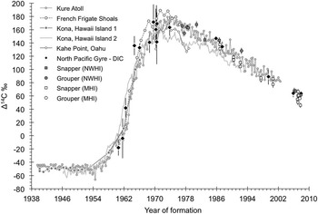
Measured ∆14C values from the otoliths of the snapper and grouper ranged as expected from near peak values in the late 1970s through a decline period with a rate that was similar to the Kure Atoll coral record (Figure 4). While otolith ∆14C values overall appear to be more variable than the coral ∆14C record, the slope (ANCOVA, n=126, P=0.088) and intercept (ANCOVA, P=0.085) were indistinguishable with an otolith decline rate of ~3.6‰ per year over 40 yr (n=29, y=–3.65x+7381, R 2=0.973). Observed variability of the otolith ∆14C values through time was also typically within the Kure pattern and on the order of ±10‰, with two outliers that were above the Kure Atoll record in 1980 and 1992. Both of these fish were from FFS and it is possible that these values represent a slightly greater ∆14C limit for FFS, as was demonstrated here with the limited FFS coral ∆14C record and DIC ∆14C measurements of the central NPG. Furthermore, otoliths from Hawaii Island were typically lower in the most recent collections (three measurements for 2007) and may reflect the more attenuated trend observed in the limited Kona 2 ∆14C decline period. Hence, subtle differences in the upper and lower limits of the regional signals may be present but were not well enough defined to make any firm conclusions because of small sample sizes and insufficient timespans (Online Supplementary Material). In addition, there was no expectation of effects from the uptake of 14C-depleted sources because the otolith core formed when the fish was a juvenile. During this early life period, these species are known to reside in the mixed layer (e.g. Andrews et al. Reference Andrews, DeMartini, Brodziak, Nichols and Humphreys2012).
Kure Atoll ∆14C record with other forms of ∆14C reference data from across the Hawaiian Archipelago and the NPG. Other data are from a long series of seawater collections and otolith samples of known collection date. Seawater ∆14C measurements were from the upper mixed layer (surface to 50 m) covering a range of sites in the NPG (Figure 5). Some of the data were a single measurement from a given collection date, while other multiple sample data sets are represented as an overall mean with 2SE to represent most of the measurement range for figure simplicity. Otolith ∆14C measurements were from juvenile or young fish with known collection dates from various locations across the Hawaiian Archipelago (Figure 1; Tables 1a,b).

DIC ∆14C Records of the North Pacific Gyre
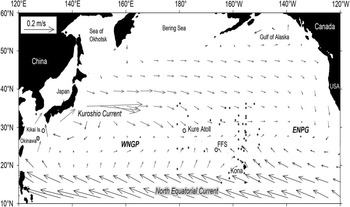
Records of ∆14C from seawater DIC provided some explanation for the observed variability of the coral ∆14C records within and between locations along the Hawaiian Archipelago (Figure 4). Selection of representative DIC samples across time and space was subjective, but was limited to the upper mixed layer of the NPG and within the current patterns associated with the Hawaiian Archipelago (Figure 5). The Hawaiian Archipelago crosses the NPG at an angle and covers nearly 10° of latitude and nearly 30° of longitude, effectively traversing the convergence area between weakly separated components of the NPG—the western NPG and the eastern NPG. The process that feeds the northwestern part of the NPG is the Kuroshio Current, which generally pushes waters from the western tropical Pacific into the central gyre region from the north and toward Kure Atoll. While FFS resides in an intermediate part of the NPG and would be influenced more from pooling waters of the gyre system, the influence from the south is the northern edge of the NEC and would be expected to influence the main Hawaiian Islands and the Kona coral record. Hence, the DIC measurement locations were selected across this region to potentially demonstrate these influences on the variability of ∆14C in the coral records from one end of the Hawaiian Archipelago to the other.
Map of the North Pacific Ocean with a mean annual current structure delineated as vectors (velocity scale upper left). The North Pacific Gyre (NPG) is represented by two weakly separated western and eastern components of the gyre (WNPG and ENPG). The three coral ∆14C records at Kure Atoll, French Frigate Shoals (FFS), and Kona of Hawaii Island delineate the Hawaiian Archipelago. The locations of DIC ∆14C records (dots among current vectors) from across the NPG were selected based on its proximity to the NPG and the Hawaiian Archipelago. These stations covered latitudes ~15°N to ~35°N and longitudes ~180° to ~150°W, a region of mixed surface waters representing potential sources of DIC to corals of the Hawaiian Archipelago. Specifics of seawater DIC measurements are available in Appendix II (Online Supplementary Material). Mean annual current structure (1993–2003) was sourced from OSCAR (NOAA/NESDIS, Ocean Surface Current Analysis – Real time; Bonjean and Lagerloef Reference Bonjean and Lagerloef2002). Okinawa and Kikai Island are also labeled as the locations of other applicable coral ∆14C records (Figure 7).

The DIC ∆14C measurements from the selected region spanned almost 50 yr, beginning with the Tethys cruise in 1960 to recent assays made during revisits to WOCE (World Ocean Experiment) stations in 2005 and 2007 (Appendix II, Online Supplementary Material). For the earliest years, there was only one applicable measurement from each cruise with a large reported error (1960, 1961, 1962); however, these values were well correlated with the coral records during the rapid ∆14C rise (Figure 4). The next three surveys included three to five DIC ∆14C samples that were applicable to the NPG region in the years 1964, 1966, and 1968. To indicate what Hawaiian corals might have sequestered for the sampled period (months of coral formation), these DIC sample sets were represented as a mean with 2SE to encompass most of the range of values reported for that water sampling date. The Ursa Major cruise in 1964 provided the timeliest ∆14C rise, earlier than the coral records by 1 to 2 yr at that level. The location of these earliest-rise ∆14C measurements was consistent with some of the highest ∆14C values reported a few years later from the NPG. The Zetes and Radford cruises provided a mix of values that begin to represent the ∆14C peak period in the NPG in 1966 and 1968. These measurements were in agreement with the maximum ∆14C rise for the coral records, but the Radford results for 1968 were more similar to the Kure Atoll and Kona 2 coral records (lower than FFS). However, the margin of error reported for the Radford survey was the greatest of all surveys considered (±18–34‰), which greatly exceeds the potential range recorded by all three coral records.
Surveys in 1969 and 1970 were well within the highly variable ∆14C peak period of the coral records. Three of these surveys (Climax II, Hudson 70, and Seven-Tow) reported some of the highest ∆14C values recorded in the North Pacific (188±9‰ to 221±15‰), all of which were northeast of the Hawaiian Archipelago (between ~25–29°N and ~150–156°W) and similar in location to the earliest ∆14C rise measured during the Ursa Major cruise in 1964. These DIC samples might represent ∆14C levels near the maximum potential atmospheric uptake of the NPG due to greater residence times in central locations of the gyre system and the lower initial CO2 saturation state of waters originating farther north (Broecker and Peng Reference Broecker and Peng1982). Because FFS is centrally located in the NPG relative to current patterns (Figure 5), the ∆14C record from this location might also resemble the highest Hawaiian coral peak of 189‰ in 1971 (Figure 4). The lower end of the ∆14C spectrum for the Hawaiian coral peak period was also well represented during this time. There was no clear spatial differentiation of the lower from the higher DIC ∆14C measurements in the 1969–1970 surveys and some observations were closer to the attenuated ∆14C peak levels observed for Oahu and Kona, Hawaii Island. One value measured during this period from the NPSC-7 cruise was considerably lower than any DIC ∆14C measurement made at this time and cannot be explained by the coral records (111±11‰). Aside from this exceptionally low value, the pattern was similar to the next and last series of DIC ∆14C records during the peak period that were recorded from GEOSECS stations in 1973. The variability of ∆14C measurements was within the range covered by the Hawaiian coral ∆14C records (Figure 4), and some of the measurement disparity of earlier records may be attributed to significantly greater measurement error due to technological limitations (typically 3 to 4 times greater than GEOSECS). The GEOSECS stations cover a wider spatial range (most other surveys were in a north-south direction) and include values that cover the ∆14C range exhibited by all of the Hawaiian coral records for 1973 (~145–187‰), exemplifying the patchy nature of 14C in the NPG during the peak period.
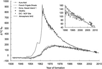
The ∆14C decline period surveys were fewer and farther between and typically limited to the North Central Pacific station (NCP, 31°N, 159°W). The measurements made in 1985 during the Alcyone-5 Cruise were the first to document the ∆14C decline in the NPG and were moderately variable over the 1-month period of monitoring (137–154‰). These values were similar to the Kure Atoll ∆14C record and greater than Kona 2, as was the case for the Eve-1 cruise in 1987 and the Avon cruise in 1999 (Figure 4). The latest series of surveys by JAMSTEC in 2005 and 2007 covered different transit lines and revisited various stations. The series from 2005 transited near latitude 24°N with four stations across the region of interest in the NPG. Despite the broad range in longitude (156°W–179°E), the ∆14C values were consistent at 64.1±6.0 (2SE). The survey in 2007 transited near longitude 179°E with four stations on the western edge of the region of interest (Figure 5). Similar to the 2005 surveys and despite the great range in latitude (19°N–35°N), the ∆14C values were consistent at 63.9±3.8 (2SE). While these dates were more recent than any of the existing coral ∆14C records, the potential ∆14C range exhibited by each survey series was similar to ∆14C values measured in reference otolith material that was collected in 2006–2007 from across the Hawaiian Archipelago (Figure 4). The DIC ∆14C records that span 1985 to 2007, coupled with known-age otolith material as a reference in the decline period, indicate there may be a common rate of decline across the region (Online Supplementary Material). The monotonic decline described by the Kure Atoll coral slope of ~3.4‰ per year was indistinguishable from the decline rate of ~3.8‰ per year for the few DIC ∆14C records available (n=5, y=–3.80+7683, R 2=0.991). The slopes of each relationship were indistinguishable (ANCOVA, n=102, P<0.61), as were their intercepts or elevations (ANCOVA P=0.235). While the power of this ANCOVA was low due to the relatively few DIC ∆14C data, there was concordance among the DIC ∆14C records during the decline period that was within an observed annual variability on the order of ±10 ‰ of the Kure coral record (Figure 4). In addition, the decline documented for the NPG by the Kure coral, fish otoliths, and DIC indicates that atmospheric ∆14C is becoming more depleted than the mixed layer in the NPG. In the years 1998 to 2000, the Kure Atoll ∆14C record began to cross the atmospheric ∆14C record and appears to continue to a more elevated level based on the most recently collected otolith samples (Figure 6).
Comparison of Kure Atoll and other ∆14C records from the region (NCP=North Central Pacific Site) with the regional atmospheric ∆14C record (NH2; Hua et al. Reference Hua, Barbetti and Rakowski2013). Of interest is the beginning of a crossover to more depleted ∆14C levels in the atmosphere relative to the mixed layer records from the Kure Atoll coral and the most recently collected otoliths. Inset reveals the crossover begins near years 1998 to 2000 and remains elevated for the last 2 yr of the record. Otoliths indicate the trend continues with most of the otoliths from 2006–2007 elevated by ~5–15‰.

CONCLUSIONS
The ∆14C record recorded in the Kure Atoll coral core provided a continuous and validated timeline for the bomb 14C signal at the northwestern end of the Hawaiian Archipelago and provided baseline ∆14C information for the NPG. The most rapid increase of ∆14C in the 1950s and 1960s was similar in timing across the Hawaiian Archipelago and provides a strong basis for high-precision age determination of marine organisms using bomb 14C dating. Furthermore, recent advances in otolith microsampling have increased confidence in the use of bomb 14C dating (Andrews et al. Reference Andrews, Choat, Hamilton and DeMartini2015). Coupled with reference otolith and DIC ∆14C records, the data series revealed a monotonic decline across the Hawaiian Archipelago, with the exception of some evidence presented at two locations in the MHI where the decline might start later and continue as an attenuated signal. Other records from across the NPG provide a clear indication that ∆14C is inherently variable in the peak and post-peak periods and appears to explain some of the differences noted for coral records across time and space. As a result, studies utilizing bomb 14C dating of fishes and other marine organisms from the Hawaiian Archipelago will need to consider spatial and temporal variability of ∆14C during the decline period when evaluating birth years and validating the corresponding age estimates of fish from various subregions of the archipelago. Despite this potential complication, the utility of the decline period can answer questions about the validity of age estimates when there is no quantifiable growth structure or when there are disparities in age interpretation scenarios that exceed ~10 yr.
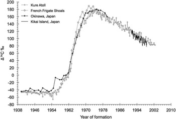
Subtle differences in the coral ∆14C records across the Hawaiian Archipelago might be explained by the large-scale ocean circulation patterns of the NPG (Figure 5). Kure Atoll appears to provide a proxy for sea surface 14C that is entering the NPG from the most easterly extent of the Kuroshio Current. Support for this notion resides in similarities of two coral ∆14C records from Japan with the Kure Atoll ∆14C record (Figure 7). The close alignment of a coarse record from Okinawa (Konishi et al. Reference Konishi, Tanaka and Sakanoue1982), coupled with a more recent ∆14C record from Kikai Island (Morimoto et al. Reference Morimoto, Kitagawa, Shibata and Kayanne2004), suggests that the Kure Atoll record is largely influenced by advection of waters from the Kuroshio Current. Hawaii Island is on the other extreme of the NPG and exhibits a signal that appears to be influenced by the NEC based on the relatively depleted ∆14C signal during the peak and decline periods. Despite the short period for the FFS ∆14C record, its more intermediate position in the NPG exhibits some of the most elevated levels of the NPG during the peak period and is consistent with the near-edge water sources of the NPG for Hawaii Island and Kure Atoll. In general, the pattern across the Hawaiian Archipelago exhibited in this study is consistent with the oceanic circulation patterns of the NPG. Additional factors that would influence measured ∆14C values include regional upwelling caused by localized conditions (current and bathymetrically induced) and strong seasonal changes in water masses and the thermocline (Rooney et al. Reference Rooney, Donham, Montgomery, Spalding, Parrish, Borland, Fenner, Gove and Vetter2010). Each could introduce deeper waters that are 14C-depleted to near surface waters where coral and otolith records are formed.
Comparison of coral ∆14C records from Okinawa (Konishi et al. Reference Konishi, Tanaka and Sakanoue1982) and Kikai Island, Japan (Morimoto et al. Reference Morimoto, Kitagawa, Shibata and Kayanne2004) with the most northerly of the NPG ∆14C records (Kure Atoll and French Frigate Shoals). The coincidence of the records provides a connection of the 14C signals to the Kuroshio Current system as a source for 14C to the NWHI environment, especially when considering the similarity of the two Japanese ∆14C records with Kure Atoll (see Figure 5). Faster ∆14C rise and greater peak for FFS can be attributed to greater residence times of central NPG waters.

ACKNOWLEDGMENTS
We thank Dr Jim Maragos (US Fish and Wildlife Service) for mentorship and field assistance while collecting the coral core at Kure atoll (D Siciliano dissertation at UC Santa Cruz). Thank you to Rob Franks (Institute of Marine Sciences, University of California, Santa Cruz) for assistance with ICP-OES analytical methods. Archived and recent otolith collections were made in part by J Uchiyama, C Kelley, S Ralston, R Nichols, and M Sundberg of NOAA Fisheries, PIFSC. Thank you to Ellen Druffel of the Department of Earth System Science at University of California, Irvine for assistance and updates on coral 14C records from the Hawaiian Islands. Thank you to Yuichiro Kumamoto of the Research Institute for Global Change, Japan Agency for Marine-Earth Science and Technology (JAMSTEC) for assistance with acquiring recent DIC radiocarbon measurements—data are available at a web page of Post-WOCE Hydrography/JAMSTEC (http://www.jamstec.go.jp/iorgc/ocorp/data/post-woce.html). We thank three anonymous reviewers for constructive feedback that improved the manuscript.
SUPPLEMENTARY MATERIAL
To view supplementary material for this article, please visit http://dx.doi.org/10.1017/RDC.2016.32