

INTRODUCTION
Since the publication of Cecil Curwen’s pioneering paper ‘Neolithic Camps’ in 1930,Footnote 1 causewayed enclosures have received considerable attention from archaeologists.Footnote 2 The corpus of certain or probable sites is still relatively small, but it has increased significantly from the original sixteen proposed by CurwenFootnote 3 to around seventy today, with almost as many possible enclosures.Footnote 4 The vast majority of these monuments, defined by interrupted circuits of bank and ditch, are located in southern England, but a handful of outliers are now known in the northern and western regions of Britain.
The search for causewayed enclosures in Wales has been erratic and of limited success. In the late 1920s, W J Hemp proposed the Montgomeryshire site of Dinas,Footnote 5 noting its morphological similarity to Knap Hill, in Wiltshire. The site was included in Curwen’s list of possible ‘camps’ given the interrupted nature of the rampart,Footnote 6 but a Neolithic date has never been confirmed through excavation. In the latter half of the twentieth century, although Neolithic deposits were occasionally encountered when excavating on hilltops throughout Wales,Footnote 7 none was identified in association with convincing traces of associated enclosure. This apparent absence of causewayed enclosures in Wales was explained away on the grounds that the Neolithic population was too scattered, or too focused on local familial relationships, to warrant large communal gathering areas.Footnote 8 Since the early 1990s, however, this position has become less convincing as an increasing number of potential Early Neolithic enclosures came to prominence, primarily as a result of aerial photography. There now exists a corpus of almost thirty enclosures that have been suggested to be Early Neolithic in date.
While many of these sites may share common morphological characteristics with the causewayed enclosures of southern England, until now only two have been definitively confirmed to be Neolithic by excavation: Womaston (in Powys)Footnote 9 and Banc Du (in Pembrokeshire).Footnote 10 However, neither site has produced the substantial assemblages of ceramics and stone tools that could be compared to the English causewayed enclosures, and only eight radiocarbon dates have so far been obtained. This paucity of excavated and well-dated sites in Wales makes any detailed understanding of the chronology and use of enclosures in the region problematic, and any new discoveries of potential high significance.
In 2014 and 2015, excavations by the authors at the hillfort of Caerau, in Cardiff, revealed the unexpected presence of another substantial Neolithic enclosure. This was defined by at least five circuits contained within the interior of the Iron Age hillfort. The Early Neolithic date of the site was confirmed through the recovery of an assemblage of ceramics, flints, polished stone axe fragments and ten radiocarbon dates from stratified contexts within the ditch-fills. In particular, the pottery assemblage is large (c 1,600 sherds) and marks the site as being exceptional in Wales, comparable with the better-known enclosures in southern England.
In ‘Gathering Time’, Whittle et al argued that the earliest Welsh enclosures arrived in Wales by 3640–3580 cal. bc, around 20–215 years after the introduction of the Neolithic (3765–3655 cal. bc),Footnote 11 but this suggestion was speculative given that only one Welsh enclosure with Neolithic dates – Banc Du – was modelled for the volume.Footnote 12 However, the radiocarbon determinations obtained from Caerau and presented here appear to support the validity of this model. This paper also considers the complex history of the site, including the deposition of a rich assemblage of material culture. Additionally, for the very first time, a complete review of the evidence for Neolithic enclosures in Wales is given in this paper, including a collection of site plans, which help to place Caerau within a wider regional context.
NEOLITHIC DISCOVERIES AT CAERAU HILLFORT
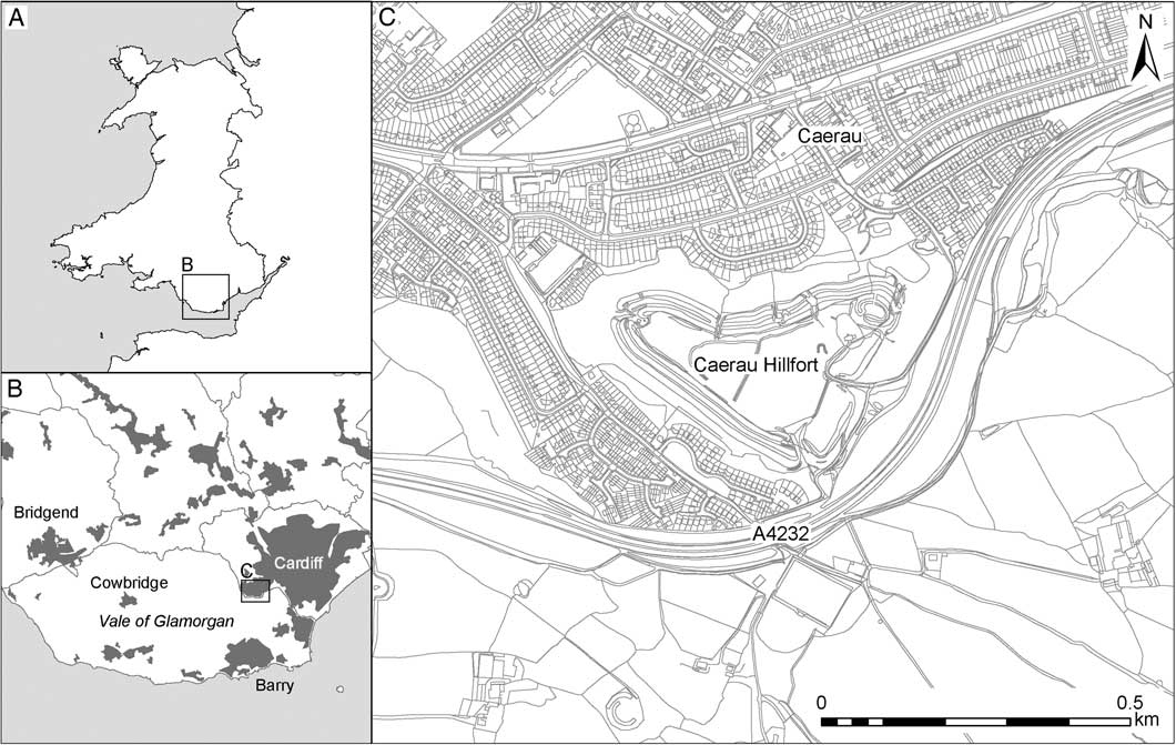
Caerau Hillfort is located on the south-west side of the modern city of Cardiff, within the suburbs of Caerau and Ely (fig 1). It occupies a promontory that is essentially an extension of the Vale of Glamorgan uplands, protruding eastwards into the coastal plain formed by the confluence of the Rivers Ely, Taff and Rhymney. The hillfort is triangular in shape, defined by three lines of bank and ditch on its northern and southern sides and a single, enormous, rampart on its eastern edge, which enclose around 5ha. The hillfort boundaries are masked by dense woodland that extends down to the housing estates of Caerau and Ely, which surround the site. The north-east corner of the hillfort has been considerably remodelled by the construction of a small medieval ringwork and church, St Mary’s.
Location map of Caerau Hillfort. Image: Crown Copyright/database right 2017. An Ordnance Survey/EDINA supplied service

Caerau had previously received very limited archaeological attention and, prior to the authors’ work, exploration had been restricted to a topographic survey of the earthworks undertaken by the RCAHMW for its inventory of Glamorgan.Footnote 13 This is one of a relatively large number of Iron Age hillforts found in the Vale of Glamorgan;Footnote 14 the majority of these are small (less than 1ha in size) and there are just five others of broadly similar size and complexity to Caerau: (i) the Bulwarks, Porthkerry; (ii) Castle Ditches, Llantwit Major; (iii) Dunraven, Southerndown; (iv) Caer Dynnaf, Cowbridge; and (v) Castle Ditches, Llancarfan. None of these hillforts has seen anything more than superficial excavation, and it is not an exaggeration to say nothing is known about their chronology and occupation. There was no evidence to suggest the presence of a Neolithic enclosure at the hillfort despite the recent identification of several potential Neolithic enclosures in the Vale of Glamorgan.Footnote 15
The Caerau And Ely Rediscovering (CAER) Heritage Project was formed in 2011 on the basis that a significant contribution could be made to knowledge of the Iron Age in western Britain through the thorough examination of one of these hillforts. Caerau was chosen because, as the largest and most complex hillfort in the region, it seemed to provide the best opportunity for the authors to answer key questions about chronology and use over time. Equally important to the authors was the potential for the co-production of archaeological and historic research with local communities. The adjacent housing estates of Caerau and Ely are two of the most socially and economically challenged wards in Wales. They have a long history of economic and social deprivation, exacerbated by low levels of employment and poor educational attainment, and the stigmas that accompany such a situation. The project aims to use historical and archaeological research to challenge the stigmas associated with living in this area, to develop educational opportunities and to widen access to higher education.
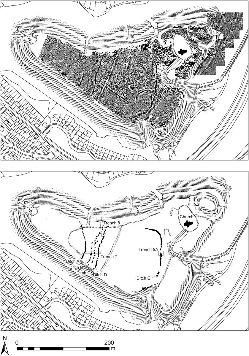
The project began with a short weekend excavation by Channel 4’s Time Team, which kicked off with the production of a geophysical survey by GSB ProspectionFootnote 16 that was subsequently completed by GeoArch.Footnote 17 This survey revealed a dense palimpsest of archaeological features that covered the interior of the hillfort and included numerous linear boundaries, a scattering of roundhouses and evidence for metalworking hearths (fig 2). None of these features showed any topographic relief or had been previously identified from aerial photography. Subsequent excavation in 2014 revealed the main complex of ditches to be the remains of a major Neolithic enclosure.
Results of the magnetometry survey of Caerau (top) and location of the trenches exploring Neolithic features (bottom). Magnetometry image: © GSB Prospection and GeoArch

The principal elements of the enclosure were four ditches cutting off the tip of the promontory on which the hillfort had been built. These ditches were labelled A, B, C and D as one moves from west to east. Ditch A meets the southern escarpment of the hill at an abrupt angle, but from there it describes a gentle curve across the interior of the hill towards the northern tip of the promontory, though its course is partially obscured by the inner rampart. The ditch showed as a prominent magnetic feature across half the interior of the hill, but then, after a clear terminal, it continued as a much more discontinuous and feint feature. The remaining three ditches in this group followed the line of Ditch A across the southern half of the hillfort interior; then, instead of continuing to follow the slope, they realigned to cut straight across the hillfort to the northern escarpment. The two middle ditches (B and C) are always feint features and follow each other quite closely, but the outer ditch (D) deviates slightly from their line and is a much stronger magnetic anomaly. These features were explored by two trenches in 2014 (trenches 7 and 8) that were re-opened in 2015.Footnote 18
In 2015, the authors also opened up trench 5A to examine another ditch (E) at the far eastern end of the hillfort, and this too, rather surprisingly, turned out to date to the Neolithic. This eastern ditch can be viewed in two ways: either it is an extension to the original enclosure, which was focused on the tip of the promontory; or it, together with Ditches B, C and D, defines a large enclosure focused on the centre of the hillfort, and that an additional and separate enclosure defined by Ditch A encloses the promontory tip. In both scenarios, the promontory tip enclosure should be earlier, as Ditches B, C and D kink to partially follow the line of Ditch A. If the outer ditch represents an addition to the original enclosure, then it increases the size of the enclosed area from 0.8ha to 3ha.
The excavation of the Neolithic enclosure has so far been limited to: a 4m-wide strip across Ditches A, B, C and D in trench 7; a 6m-wide strip along Ditch D in trench 8; and a 2m-wide strip across Ditch E in trench 5A – though this trench included a partial exploration of the ditch terminal.
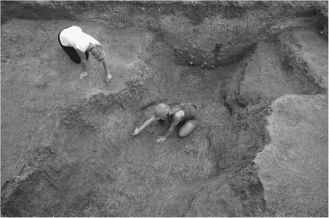
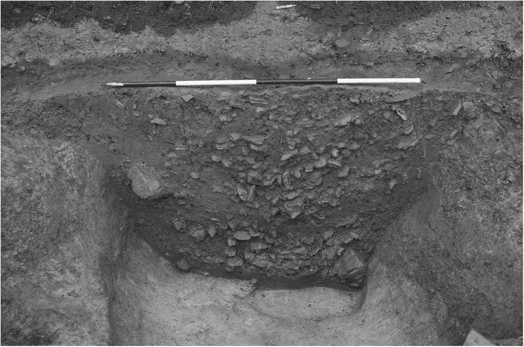
The excavation of trench 7 revealed considerable differences in the form and fill of the four main ditches. The most striking differences are between Ditches A and D, which are prominent features on the geophysical survey, and Ditches B and C, which are much less visible. Ditch A was substantial (fig 3), broadly U-shaped in profile, 2m wide and 1.3m deep. Its basal fill was silty and probably accumulated relatively quickly as rain eroded the sides of the newly dug ditch. Cutting through this deposit was a posthole, which was sealed by a layer of stones apparently placed deliberately in the bottom of the ditch. Degraded animal bone, pottery and a fragment of a polished stone axe were placed on top of this layer of stones. After subsequent silting, the ditch was re-cut to a depth of around 0.75m. The re-cut contained a layer of charcoal-enriched soil and produced three leaf-shaped arrowheads, over 100 sherds of pottery and a polished axe fragment.
Ditch A fully excavated looking north

Ditch D was a significant feature, comparable in size and shape with Ditch A, and containing a similar fill sequence. The sequence began with a primary silt layer that was sealed by a layer of stones, which contained a few sherds of Neolithic pottery; after a period of natural silting that infilled the ditch with a thick layer of clayey silt, there was then a re-cut that was filled with a charcoal-rich soil, which produced numerous pot sherds and flints. The section of Ditch D excavated in trench 8 was of different character: it was much shallower, being only 0.5m in depth, and its width varied drastically from 2.7m at its southern end to 1.3m at its northern extent. During excavation, it became clear that the ditch in this trench was not originally continuous, but it was constructed of two elongated segments that had been joined together at a later date. A few sherds of pottery, flints and a polished axe fragment were recovered from the fills, which also contained a very large, angular, stone, over 0.7m wide and 0.6m long. Several large flakes had been knocked off this boulder, but it could not be said to be shaped. It had been deliberately placed in the upper fill of the ditch and may have been a closing deposit.
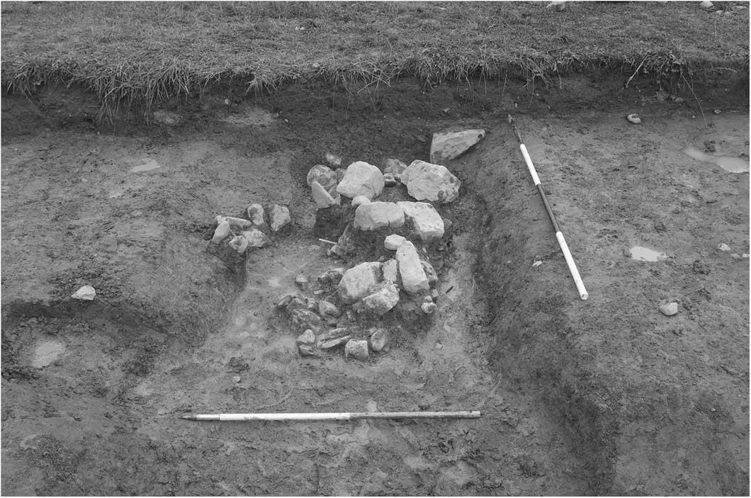
The morphology and fills of the middle ditches were quite different. Ditch B was U-shaped, 1m wide but only 0.3m deep. The primary deposit was again a layer of stones apparently placed deliberately in the bottom of the ditch, but this was sealed by a thick layer of natural silt (fig 4). Several voids observed within this stony deposit may have been the settings for posts. Ditch C was similarly narrow and shallow, but was largely sterile and produced no material culture.
Ditch B during excavation, looking north. Note the shallowness of the profile and the layer of stones placed upon the primary silts

The examination of Ditch E was restricted to a 1.5m-wide cutting through the fills on the south side of trench 5A, though a large area of the upper fills was also removed from the terminal of the ditch. This was a substantial U-shaped ditch, 3.5m wide and 1.6m deep (fig 5). The fill sequence was complex, but can be summarised as a primary, stone-free silt, sealed by brown sandy deposits containing occasional stones and charcoal flecks and then a thick layer of medium- to small-fractured stone with, initially, a dark reddish-brown, then a greenish-brown, silty, clay matrix. This was sealed by a dark-brown clay with frequent charcoal flecks that contained a large number of pottery sherds and some small fragments of burnt bone, and was overlain by more thick clay layers. This deposit largely infilled the ditch, which was then re-cut at least once, and possibly twice. The re-cuts were filled with brown silty clays with charcoal inclusions.
Ditch E after excavation, looking south

The exceptional size and quality of the ceramic assemblage from the fills at the terminal of this ditch suggest that this was a significant entrance into the Neolithic enclosure. That it is aligned with the later hillfort entrance may suggest it survived as a slight, but important, feature that guided the layout of the Iron Age boundaries. It is possible that further Neolithic ditch circuits exist to the east of this boundary ditch, in areas concealed by the later hillfort ramparts.
Lithics
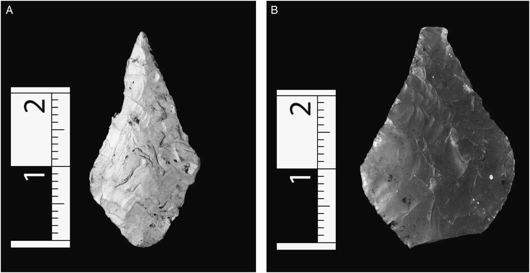
The flint assemblage from the enclosure ditches is modest (c 350 pieces), but of a vastly greater magnitude than that recovered from stratified deposits at any other Welsh causewayed enclosure. It is characterised by small lithic debitage (chips and small flakes), which indicates that the raw material was carried to the site and worked in situ. The raw material (flint) was probably pebbles (from beaches, rivers and glacial deposits), as there is no large geological deposit in the vicinity. So far, the authors have identified four scrapers, two piercers and six leaf-shaped arrowheads among the assemblage. Initial use-wear analysis of a small selection of the assemblage by Peter Bye-Jensen has shown that all analysed flint artefacts had traces of use. Of the arrowheads, two leaf forms are represented: the kite-shaped (Type 2C) form, which is long, slender with symmetrical upper and lower halves, and the ogival (Type 3B), which is short with two concave upper sidesFootnote 19 (fig 6). The arrowheads were clustered primarily within the charcoal-rich layers in Ditches A and D, and all but one were broken. The number of arrowheads is relatively large, given the authors’ rather limited interventions, and the arrowheads’ association with burnt layers within the ditches could tentatively suggest that there had been a violent assault on the enclosure similar to that documented at Crickley Hill (in the Cotswolds).Footnote 20 It should also be noted that thirty leaf-shaped projectile points were recovered during fieldwalking at the nearby Corntown enclosure in the Vale of Glamorgan.
Examples of Early Neolithic flint arrowheads from Caerau: A – kite-shape; B – ogival-shape

To date, no complete axes have been recovered, but a total of twelve polished axe fragments have been identified from the lithic assemblage at Caerau. One is a small flake from a flint axe, which are relatively common in the Cardiff area.Footnote 21 However, the majority of the stone axes are homogeneous acid tuffs. They still await detailed petrological analysis, but initial examination by Jana Horak (National Museum Wales) suggests that the majority derive from south-west Wales (Group VIII). A substantial portion of a micro Gabbroic axe was also found, which could have been sourced from St David’s Head, in Pembrokeshire, or west Cornwall.
The Caerau pottery (Jody Deacon)
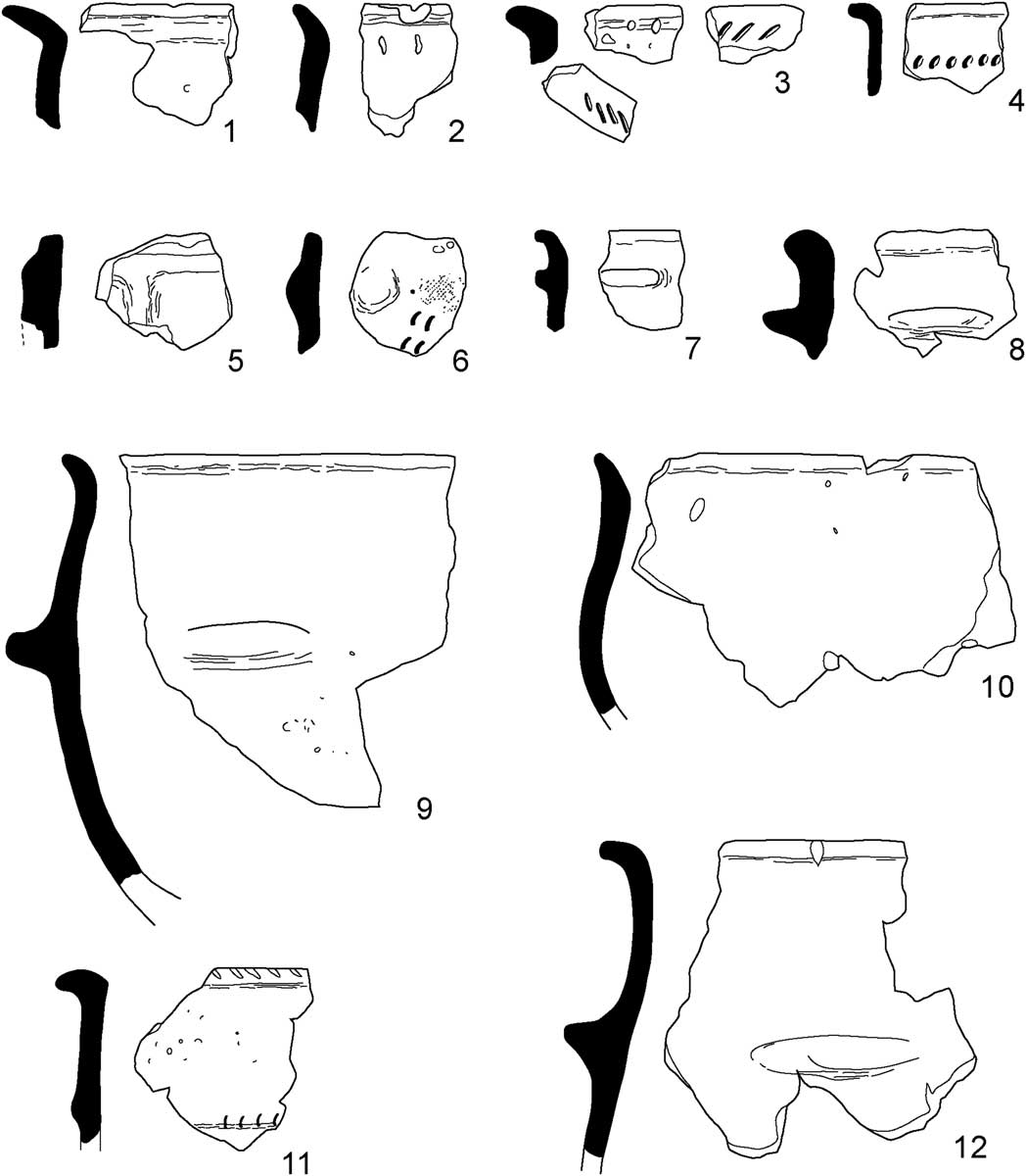
In total, 1,683 sherds of Neolithic pottery, representing at least sixty-nine vessels, were recovered from the excavations, making this the largest assemblage of Early Neolithic pottery from Wales. The assemblage comprises highly fragmented bowl pottery, displaying traits mainly comparable with pottery of the Decorated tradition of southern England (fig 7). Most vessels possess neutral profiles. However, approximately half the sherds for which the overall shape could be determined are vessels with open or closed profiles, suggesting a wide range of functional uses for the vessels deposited. The assemblage is dominated by quartz and vesicular fabrics, probably originally containing calcite, which is well attested within Early Neolithic pottery assemblages in Wales.Footnote 22 However, the ‘corky’ Irish Sea fabrics of the earliest Neolithic in Wales (c 4000–3700 cal. bc)Footnote 23 and the Gabbroic fabrics derived from the Lizard peninsular in Cornwall, and associated with the South-Western pottery style, are absent from the Caerau assemblage.
Selection of Early Neolithic vessel forms recovered from the enclosure ditches at Caerau (1–12)

Twenty-seven decorated sherds were identified as well as ten sherds with applied lugs. Decoration is largely restricted to oblique incised or impressed lines along the tops of flattened or heavy rims, characteristic of the Decorated tradition. However, a small group of eight unusually decorated sherds were recovered from the lower fills of Ditch E adjacent to the proposed causeway or entrance. Several of the sherds are decorated directly beneath their rims with rows of fingernail or fingertip impressions. Such decorative techniques do occasionally occur within Decorated assemblages, but not at this point on the neck. No direct parallels have been identified for this decoration, and it could be a regional expression of the Decorated style. Perhaps the most interesting sherd of this group was a body sherd of a finely made vessel in an oxidised, micaceous fabric. It was decorated with a circular applied boss, originally paired with another closely spaced matching boss, which detached prior to deposition. Fingernail impressions arranged in parallel lines beneath the boss suggest the lower part of the vessel was also decorated (see fig 7 (6)). The sherd is difficult to parallel within any southern British assemblage, suggesting a non-local origin. A fragmentary single boss with fingernail impressions above was found at Hambledon Hill,Footnote 24 but the best parallels for paired, rather than singular, bosses are found within the Chasséen pottery assemblages of the northern French Middle Neolithic II at sites such as Sandun, Loire Atlantique.Footnote 25 The dating of this material is generally slightly earlier than the British material.Footnote 26 However, it does overlap with the period of contact in the thirty-ninth century bc between Normandy, Brittany and south-west England proposed by Sheridan,Footnote 27 with its tentative suggestion of contact along the northern coast of the south-west peninsula into the Severn Estuary.
Overall, the majority of the Caerau assemblage finds closest parallel with the Decorated assemblages of southern England, and suggests influences and connections with these areas. However, it should be noted that there is an absence of bowls displaying the clear vertical grooves and pinprick decoration that ornament a significant proportion of the vessels from sites such as Windmill Hill, in Abingdon, and Hambledon Hill, in Dorset.Footnote 28 Interestingly, while the Gabbroic fabrics and the fine black surfaces associated with the South-Western pottery traditions have not been identified at Caerau, there are certain characteristics of the material, such as the proportion of open bowls and the presence of circular lugs and bosses, which are more frequently associated with assemblages of this tradition. The distinctive features of the Caerau assemblage raises the possibility of the emergence of a distinct regional style of Welsh Neolithic pottery after c 3600 bc, but this will need confirmation through further excavation and new discoveries.
CHRONOLOGY
In ‘Gathering Time’, Whittle et al argued that the earliest British causewayed enclosures started in the Thames estuary and then quickly spread around the coast to Cornwall and Devon, Sussex and East Anglia.Footnote 29 They then spread from these areas into the Thames Valley and Wessex before reaching the Cotswolds and, finally, Wales. The model suggested the arrival in Wales around 3640–3580 cal. bc. In some respects, the date for the arrival of enclosures in Wales was more of a prediction, given that it was based only upon dates obtained from a single site – that of Banc Du, in Pembrokeshire.Footnote 30 Since then, radiocarbon determinations from a second causewayed enclosure – that of Womaston, in the Walton Basin – have been published.Footnote 31 Only three radiocarbon dates were obtained, but they suggested activity at Womaston in the period from 3600–3400 cal. bc.
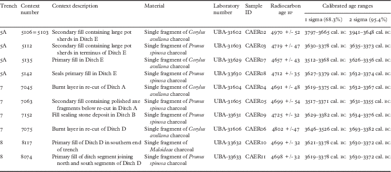
Part of the excavation programme at Caerau has included the intensive sampling of the Neolithic ditch-fills. After preliminary analysis, the authors have now obtained an initial ten radiocarbon dates from these deposits (table 1). Charcoal samples of short-lived species were selected from secure contexts and processed by CHRONO of Queens University, in Belfast. The dates form a coherent group, suggesting that the enclosure was being used between 3600 and 3400 cal. bc. The enclosure is, therefore, broadly contemporary with Banc Du and Womaston and the dates fit the model put forward by Whittle et al.Footnote 32 However, establishing a convincing chronology for the spread of these monuments into Wales is not straightforward. Only five dates were obtained from Banc Du and three from Womaston. Even at Caerau, ten dates form a relatively small number, and the authors do not yet possess dates from stratigraphic sequences and primary fills that would enable a detailed Bayesian analysis and secure the precise dates that are now possible. It is not certain that the authors have yet dated the earliest phases at Caerau, or found the earliest enclosures in Wales. The assertion by Bayliss et al that the first enclosures in Wales were built 20–215 years after the introduction of the Neolithic still requires further confirmation.Footnote 33
Radiocarbon samples and dates from the enclosure ditches at Caerau

EARLY NEOLITHIC ENCLOSURES IN WALES: A REVIEW OF THE EVIDENCE
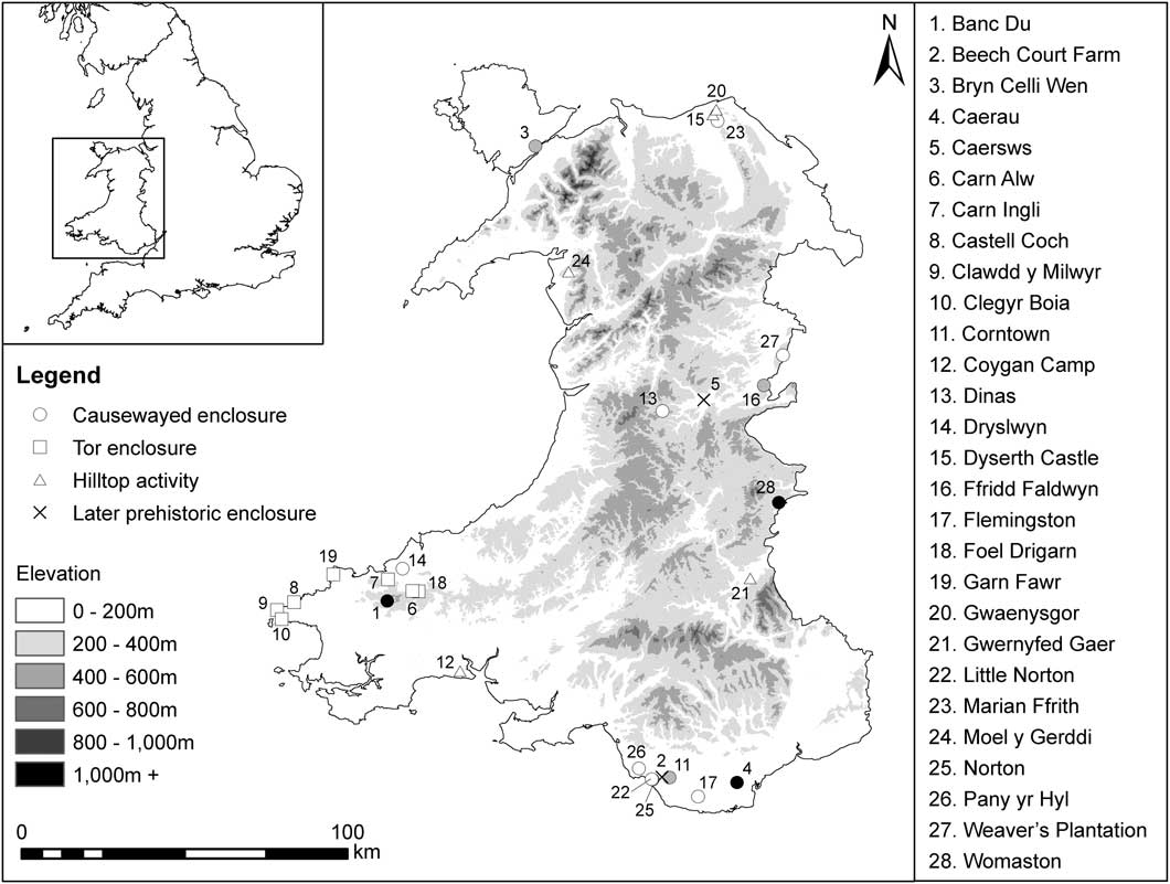
While there are three confirmed Neolithic enclosures in Wales, a large number of other sites have been put forward as candidates over the last eighty years. Through the systematic examination of data derived from the National Monuments Record (NMR), regional Historic Environment Records (HERs) and all published and unpublished sources, this study brings together the first corpus of sites that may represent Early Neolithic enclosures in Wales (fig 8 and Supplementary Material 1). The evidence is highly variable and, though all sites are included for the sake of completeness, they are listed with varying degrees of confidence:
The distribution of potential Early Neolithic enclosures in Wales (black=definite enclosure; grey=probable enclosure; white=possible enclosure)

-
· Definite enclosure: morphological similarity to other known Early Neolithic enclosures, Early Neolithic material culture and/or Early Neolithic radiocarbon dates recovered from features with secure stratigraphic contexts.
-
· Probable enclosure: morphological similarity to other known Early Neolithic enclosures and Early Neolithic material culture recovered from the location.
-
· Possible enclosure: morphological similarity to other known Early Neolithic enclosures or Early Neolithic material culture recovered from hilltop location.
-
· Rejected: material culture and/or radiocarbon dates recovered from features with secure stratigraphic contexts are not Early Neolithic.
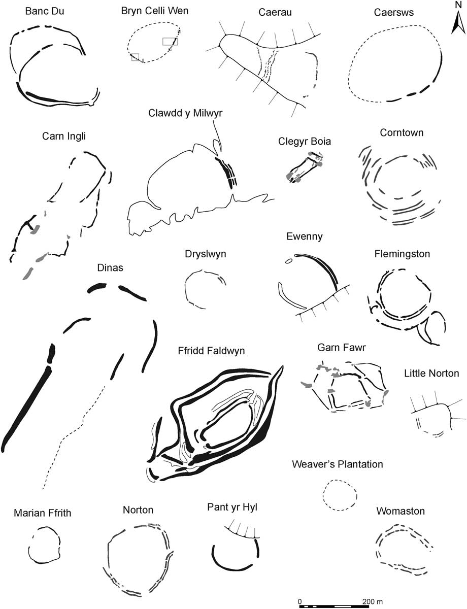
This study also provides the first published transcription of all known or potential Early Neolithic enclosures generated from aerial photographs, LiDAR, geophysical survey data or earthwork surveys at 1:1,000 (fig 9). A total of twenty-eight potential sites have been identified. These are dispersed throughout the country, but with obvious concentrations in Pembrokeshire, the Severn Valley and the Vale of Glamorgan.
Comparative plans of potential Early Neolithic enclosures (for sources, see SM 1)

Enclosures in Pembrokeshire
The first causewayed enclosure to be definitively confirmed in Wales was that of Banc Du, in Pembrokeshire. Originally discovered in 1990 through aerial photography by the RCAHMW, the enclosure is located on a low hill and has an asymmetrical circuit surviving as a low earthwork. On the gentle western slopes are two lines of ditch and bank, but on the steeper craggy slopes on the east side only one line is visible. It was subject to geophysical and topographic survey in the early 2000s as part of the SPACES project and, in 2005, a small evaluation trench was excavated across the inner bank and ditch on the west side.Footnote 34 The cutting revealed a U-shaped ditch around 1m in depth with an accompanying bank that survives to about 0.4m high and 3.8m wide. Postholes at the front and rear of the bank suggested some kind of timber lacing, and a layer of stones on the base of the ditch was interpreted as collapse from a revetment.Footnote 35 The ditch produced no material culture, but enough charcoal was recovered for six radiocarbon determinations dated for the Gathering Time project.Footnote 36 Two of these dates came from the primary fills of the ditch, suggesting that it was cut in 3645–3490 cal. bc (84 per cent probability). The other four radiocarbon samples were taken from the fills of a re-cut and produced dates in the mid- to late fourth millennium, suggesting a significant gap of perhaps 80–570 years between the original construction of the enclosure and the re-cut.Footnote 37
Another potential causewayed enclosure was identified at Dryslwyn as a cropmark by aerial photography in 2013.Footnote 38 Located about 10km north-east of Banc Du, this is a roughly circular enclosure defined by a single interrupted-ditched circuit, except on the north-east side where two bivallate sections are apparent. No indication of any ditch was identified on the south-east side where the enclosure abuts a steep scarp. At least seven gaps are visible in its circuit, with one in both the north and south sides defined by out-flaring ditch terminals. The enclosure was subject to a small-scale excavation in 2015 by Tim Darvill and Geoff Wainwright. Again, no material culture was identified, but charcoal was recovered, although this still awaits identification and dating.Footnote 39
Seven other sites in Pembrokeshire have been suggested as potential Early Neolithic enclosures based largely on their morphological similarity with the stone-built tor enclosures of Cornwall.Footnote 40 Cornish tor enclosures, such as Carn Brae and Helman Tor,Footnote 41 are characterised by low, stone-built walls, often with multiple, narrow entrances that surround or incorporate tors and other natural rock outcrops.Footnote 42 Although no definite examples exist in Pembrokeshire, the most convincing is probably that at Clegyr Boia. The site occupies a low, rocky outcrop around 2km west of St David’s, and is enclosed by a stone wall that runs around the edge of the hilltop between rock outcrops. A narrow entrance passage, defined by a pair of orthostatic walls, is located in the west. Long considered to be an Iron Age or Early Medieval hillfort. It has been excavated twice and has produced a large assemblage of Neolithic bowl pottery, flint tools, polished axe fragments and the remains of two sub-rectangular houses.Footnote 43 The problem in assigning the enclosure a Neolithic date is that on the northern side the stone-built wall can be seen to overlie one of the Neolithic houses. Vyner has argued that this represents two phases of Neolithic activity: an initial open settlement that was later enclosed within a stone-walled rampart.Footnote 44 This is certainly possible, but two radiocarbon determinations from the interior and the entrance passage produced Iron Age dates,Footnote 45 although it is possible that this later prehistoric activity involved the refurbishment of an earlier enclosure.
A range of other stone-walled enclosures in Pembrokeshire have also been considered to originate in the Neolithic. These include the coastal promontory forts of Clawdd y Milwyr and Castell Coch and inland hillforts of Garn Fawr, Carn Ingli, Carn Alw and Foel Drigarn.Footnote 46 In each case, a Neolithic date has been proposed because they display features clearly of multiple periods, or possess perceived morphological similarities with other tor enclosures. Only Clawdd y Milwyr has been excavated,Footnote 47 and none has produced Neolithic material, so an early date for these sites is far from certain and can only be resolved by future excavation.
Enclosures in the Severn Valley
Another cluster of potential Early Neolithic enclosures lies in the Upper Severn Valley and Welsh Marches. The most important, archaeologically, is that of Womaston, as it was the second causewayed enclosure in Wales proven to be Neolithic in date. The site is located in the Walton Basin and forms part of an extremely important complex of Neolithic sites, including cursus monuments, palisaded enclosures, ring-ditches, barrows and stone circles.Footnote 48 The plan of the enclosure was revealed through a combination of aerial reconnaissance and geophysical survey,Footnote 49 and comprises a closely set pair of concentric, interrupted ditches defining a roughly oval area. There is the suggestion of an ‘entrance’ on the southern side, where one of the ditch terminals is apparently in-turned.
A single trench was excavated on the east side that explored both ditch circuits and included one of the ditch terminals visible on the geophysical survey.Footnote 50 The outer ditch was shown to be U-shaped, 2.8m wide and 1.8m deep, and appeared to have been infilled by natural silting. A shallow scoop had been cut into the ditch once it had largely filled, the base of which contained a spread of charcoal-rich soil. The inner ditch was also U-shaped, 2.3m wide and 1.8m deep, and again had probably filled naturally. Sometime after the ditch had filled, a shallow re-cut was excavated, and into this a number of flat stones was placed. The material assemblage from the ditches was meagre, with only two pieces of flint and around twenty sherds of pottery recovered. Unfortunately, the majority of the sherds was small and undiagnostic, but a single everted rim of an open bowl suggested an Early Neolithic date.Footnote 51 Three radiocarbon determinations were obtained from the ditch-fills. A single sample from the primary silts of the inner ditch provided a date of 3630–3360 cal. bc, while charcoal from the re-cut produced a date of 3660–3380 cal. bc. No datable material was recovered from the basal fills of the outer ditch, but charcoal from the scoop cut into the upper layers produced a date of 3620–3340 cal. bc.
Another potential causewayed enclosure in the Severn Valley was identified through aerial photography in 2006, just east of Welshpool, at Weaver’s Plantation.Footnote 52 This cropmark site comprises the arc of a single interrupted ditch circuit defining a probable circular enclosure. While the morphology of the enclosure suggests a Neolithic date, it is by no means certain. That a degree of interpretive restraint is required is indicated by the investigation of an enclosure at Caersws by the Clwyd-Powys Archaeological Trust in the early 1990s. Superficially of similar form with interrupted ditches and banks, trial excavations produced Iron Age radiocarbon dates from the basal ditch-fills.Footnote 53
Two other sites have also been proposed as potential Neolithic enclosures. The interrupted nature of the rampart led Hemp to suggest that the hillfort of Dinas, Trefeglwys, may be of Neolithic origin, although this has never been demonstrated through excavation.Footnote 54 However, in the 1930s, excavations at the nearby Iron Age hillfort of Ffridd Faldwyn did identify Neolithic deposits that produced pottery, flints and a polished axe fragment.Footnote 55 Although O’Neil was aware of the existence of ‘Neolithic camps’, the site was dismissed as a causewayed enclosure at the time because he considered the boundaries, in which an initial enclosure by a palisade was replaced by a rampart with external ditch (IA) and subsequently re-cut (IB), to be entirely Iron Age in origin.Footnote 56 The results of O’Neil’s excavations have been much discussed. In the early 1980s, Graham Guilbert reinterpreted some of O’Neil’s conclusions based upon findings from hillfort excavations elsewhere, but still considered the boundaries to be later prehistoric in date.Footnote 57 A detailed re-analysis of the original section drawings by C J Arnold, however, has raised the possibility that ditch IA may be Neolithic given its U-shaped profile (unlike the V-shape profile of IB) and the deliberate deposition of burnt material.Footnote 58 Only further research and radiocarbon dating of archived material could resolve this issue.
Enclosures in North Wales
Two enclosures have been suggested to have Early Neolithic origins in North Wales. Bryn Celli Wen, in southern Anglesey, was located during the course of a test-pit survey in the environs of the Bryn Celli Ddu chambered tomb, and subsequently excavated.Footnote 59 The site comprises an interrupted ditch that arcs irregularly around the end of a low spur forming a rough oval. The excavated ditch segments were shallow, but possessed complex fills in which large stones were deliberately placed. All of the ditches were re-cut and, in some cases, posts appeared to have been inserted into the backfill. The excavators interpreted these as markers of some kind rather than the structural elements of buildings.Footnote 60 Particularly surprising was the identification of a linear stone cairn, piled over the broken remains of a large monolith, which appeared to have been inserted into a pit that formed part of the enclosure circuit. Although no radiocarbon dates have been published, an Early Neolithic date is suggested by the recovery of flints, a complete polished flint axe and a small assemblage of highly fragmented Neolithic bowl pottery. The site was dismissed as unconvincing as a causewayed enclosure by Francis Lynch,Footnote 61 and the ditches are not the prominent features one might expect of a causewayed enclosure. Given the recent remarkable discovery of three Early Neolithic houses at Llanfaethlu,Footnote 62 and the concentration of Neolithic tombs in the area, the presence of Early Neolithic activity seems less problematic.
Currently, the only other candidate for a causewayed enclosure in North Wales is that of Marian Ffrith, in Denbighshire. The site comprises a bank and ditch forming an irregular oval. It was identified in 1983 from aerial photography, but classified as an Iron Age enclosure by the Clwyd-Powys Archaeological Trust, which surveyed the site in the 1990s.Footnote 63 However, further aerial reconnaissance by Toby Driver of the RCAHMW highlighted the interrupted nature of its bank sections.Footnote 64 A field visit by one of the authors (Davis) and Toby Driver in 2011 confirmed that the bank is constructed as a series of discrete sections, suggesting that a Neolithic date is possible.
Enclosures in the Vale of Glamorgan
The main concentration of causewayed enclosures is in South Wales, in the Vale of Glamorgan, where six potential examples (other than Caerau) are known. All except one have been identified through aerial photography, which is unsurprising given that the area is well known for its cropmark archaeology.Footnote 65 That causewayed enclosures should form part of the Neolithic landscape on the western side of the Severn Estuary had long been expected, particularly given the high concentration of flint scatters, large collection of polished stone axes and the presence of Cotswold–Severn chambered tombs, such as Tinkinswood and St Lythans, in the area.Footnote 66 It is one of the most agriculturally fertile areas in Wales and the topography is similar to parts of Gloucestershire, where causewayed enclosures are well known.
The enclosure at Corntown, around 6km from the mouth of the River Ogmore, was identified as a cropmark in 1995.Footnote 67 The valley of the Ogmore has produced large quantities of Early Neolithic material, including a significant lithic assemblage at the site of Ogmore-by-SeaFootnote 68 and a range of leaf-shaped arrowheads and polished axes from Merthyr Mawr Warren.Footnote 69 The Corntown site is substantial and consists of an inner, egg-shaped enclosure defined by three or four close-set concentric ditches and an outer enclosure defined by another pair of close-set ditches. The cropmark evidence is obscured in places by the underlying geology,Footnote 70 but this does seem to be an exceptionally complex site with no clear parallels in Britain. The significance of the site was enhanced by the recovery of a large flint assemblage from fieldwalking over a number of years. In 2001, an assemblage of 2,866 flints was reported,Footnote 71 and this represents one of the most substantial found in South Wales. The majority of the assemblage appears to be of Early Neolithic date and includes thirty leaf-shaped arrowheads and eight flakes from polished stone axes. This collection certainly supports the suggestion that this is a Neolithic causewayed enclosure, but there has been no excavation to confirm the antiquity of the ditches.
Around 5km west of the Corntown enclosure, close to the estuary of River Ogmore, a second potential causewayed enclosure was identified as a cropmark in 1996 at Norton.Footnote 72 It consists of two closely set interrupted ditches enclosing a roughly circular area of 2.6ha. There are four possible major entrances orientated towards the cardinal compass points. The entrances in the north, east and west appear formally defined by out-flaring ditches, a feature also apparent at Flemingston (see below) and Dryslwyn, but otherwise difficult to parallel. A fieldwalking survey in the late 1990s recovered a transverse arrowhead and a few flint flakes,Footnote 73 but the quantity of material was in no way comparable to Corntown. The site was chosen for a trial excavation by the Glamorgan and Gwent Archaeological Trust in 2006.Footnote 74 Four trenches were cut across the enclosure ditches, but only the inner ditch on the southern side was bottomed. This showed that it was a rock-cut, U-shaped ditch, 3.5m wide and 1.4m deep. The basal fill was almost entirely composed of rubble, possibly the remains of a bank or wall that had been back-filled into the ditch. The ditch was then apparently left open to silt naturally.Footnote 75
The excavation of the eastern entrance was less successful. The aerial photograph appeared to show a pair of out-flaring ditches with a large pit set immediately outside. The trench positioned in this area was only able to identify a single rock-cut feature through which a small sondage was excavated to locate the base. Two radiocarbon determinations were obtained from a carbonised cereal grain and hazelnut shell fragment recovered from the basal fill of this feature, but produced dates ranging from the Early Medieval to late Tudor period. The excavators interpreted the sampled material as intrusive,Footnote 76 but it was not clear whether the feature excavated was, in fact, one of the enclosure ditches, or, what would appear more likely, the large pit. Fragments of animal bone recovered from the basal fill of the inner ditch on the southern side of the enclosure were not dated. Only three undiagnostic flints were recovered from the excavation and, given the potentially misleading radiocarbon dates, the enclosure’s Early Neolithic origins remain unconfirmed.
Around 150m north-west of the Norton enclosure is the cropmark of a pair of interrupted ditches, which arc across and enclose the end of a triangular promontory overlooking the Ogmore estuary (Little Norton). Discovered in 2006,Footnote 77 its proximity to Norton and the apparent causewayed nature of the ditches suggest that this may also be an Early Neolithic enclosure, but it has not been further explored.
Nearby is the enigmatic enclosure at Beech Court Farm, Ewenny. The site consists of a sub-circular ditch and bank that survives as a low earthwork. The enclosure has been long known about, but geophysical survey in the late 1990s, in advance of quarrying, suggested that the bank and ditch were segmented and a Neolithic date was postulated.Footnote 78 The site was subsequently extensively excavated in 2002, which confirmed that the ditch and bank were incomplete, with a very large gap on the west side. Cuttings across the ditch showed that its profile was very irregular, abruptly changing from deep to shallow along its length. Very few finds were recovered from the ditch, but within the interior a flint assemblage, Late Neolithic or Early Bronze Age in character, was identified and several sherds of a collared urn were recovered from a posthole, indicating activity on the hill in the Bronze Age. The excavation has not been fully published, but two radiocarbon samples from the ditch were submitted for dating as part of the Gathering Time project.Footnote 79 These produced Iron Age dates suggesting that the enclosure was constructed in or before 195–50 cal. bc. Almost certainly, this is not a Neolithic enclosure, and most probably represents an unfinished hillfort.
Situated on the other side of the Ogmore valley, just to the north of Porthcawl, is the potential enclosure at Pant yr Hyl. Identified through aerial photography in 1995, the enclosure is defined by a single earthwork bank and ditch defining an oval area and straddling the summit of a low ridge. It was proposed as a causewayed enclosure by Zienkiewicz,Footnote 80 possibly because of its close association with two other important Neolithic sites: it is located some 2.5km west of Tythegston long barrow and 500m south of a Neolithic house identified by Savory at Mount Pleasant Farm.Footnote 81 Claims of a Neolithic origin were reiterated by Driver, who noted its similarity in morphology and setting to Ewenny.Footnote 82 Since Ewenny has now been shown definitively to be later prehistoric, an Early Neolithic date for Pant yr Hyl seems much less likely. Moreover, an analysis of recently obtained LiDAR data clearly shows a continuous bank with only a single gap, presumably an entrance on the south-eastern side. While this may represent a Neolithic enclosure, it is much more likely to be Iron Age in date.
The other potential Neolithic enclosure in the Vale of Glamorgan is situated at Flemingston, some 500m north of RAF St Athan. The enclosure was discovered as a cropmark in 2006, but does survive as a low earthwork in places. It occupies a rounded bluff overlooking the River Thaw to the east. The enclosure comprises a pair of closely set interrupted ditches, which define a roughly circular area. On the western side, the outer ditch of this pair appears to curve outwards, possibly defining a formal entrance. A single outer ditch is also clearly identifiable on the southern and western side of the circuit. The enclosure has not been further explored, but the morphology has much in common with Norton and Corntown.
Neolithic hilltop activity
A number of other Neolithic assemblages have been recovered from various hilltops around Wales that are clearly not defined by causewayed circuits. At Coygan Camp, in Carmarthenshire, a pit containing approximately twenty sherds of bowl pottery, a triangular arrowhead, hazelnut shells and the bones of cattle and sheep, were found beneath the later Iron Age hillfort rampart.Footnote 83 Similar deposits were found behind the Iron Age rampart at Gwernyfed Gaer, in Brecknockshire,Footnote 84 and beneath the foundations of Dyserth Castle, in Denbighshire.Footnote 85 Just 2km from Dyserth, Early Neolithic flint and pottery were recovered from beneath a barrow on the hilltop of Bryn Llwyn, Gwaenysgor,Footnote 86 while a single pit at the Iron Age site of Moel y Gerddi, Gwynedd, produced a radiocarbon date of 3530–3090 cal. bc. Footnote 87 It is difficult to assess the significance of these deposits. In the early 2000s, Burrow argued that, given their prominent locations, they may represent the remains of communal meeting or gathering placesFootnote 88 – in a sense, causewayed enclosures without the enclosures. This conclusion seems less convincing now that we know the causewayed enclosure tradition was more prevalent in Wales than previously considered, and they may simply relate to occupation.
DISCUSSION
Caerau represents only the third causewayed enclosure to be definitively confirmed in Wales and is the farthest east, yet discovered, on the north side of the Severn Estuary. Current dating – confirmed here – suggests enclosures in Wales began to appear and be used during the period 3600–3400 cal. bc. The excavations at Caerau have so far been limited, focusing on several 4m-wide cuttings across the enclosure ditches. We have a limited understanding of the spatial organisation of any structures or associated activities within the interior of the enclosure complex. However, in material terms, the enclosure ditches have produced one of the largest assemblages of Neolithic flint and pottery from Wales and certainly the largest recovered from a causewayed enclosure. The quantity of pottery from Caerau is particularly substantial and initial analysis suggests it has several distinctive regional characteristics. The presence of polished stone axes from west Wales and an exotic sherd decorated with applied bosses, possibly derived from northern France, suggests that the people who occupied south-east Wales had connections over very considerable distances.
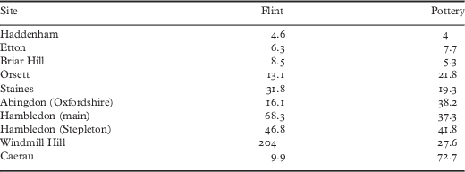
The material assemblage is also not insignificant compared to other British causewayed enclosures. A comparison of the mean densities of pottery and flint (per metre length of ditch circuit) from three enclosures in three different environmental zones across Britain has been attempted by Evans and Hodder and indicate quite distinct patterns.Footnote 89 The eastern enclosures of Etton (in Yorkshire), Haddenham (in Cambridgeshire) and Briar Hill (in Northamptonshire) are very impoverished and have only small assemblages. The Thames Valley enclosures of Orsett, Abingdon and Staines have reasonable quantities of pottery and flint. The Wessex enclosures (Hambledon – main enclosure and Stepleton – and Windmill Hill) have reasonable quantities of pottery and very large assemblages of flint, though this is not surprising given the natural availability of flint in these chalk areas. When Caerau is added for comparison (table 2), it can be seen to have a low density of flint, but not as low as observed in eastern England, and the density of pottery is much higher than any other area. This pattern is very distinctive and not what one would expect on the basis of the other two confirmed Neolithic enclosures in Wales.
Comparison of mean densities of pottery and flint per metre length of ditch from enclosures in different environmental zones across Britain (data derived from Evans and Hodder Reference Evans and Hodder2006, table 5.35)

Although three causewayed enclosures have now been confirmed in Wales, it is still unclear how many others await discovery. A further twenty-five sites have been proposed as candidates. Some of these, such as Corntown and Flemingston (in the Vale of Glamorgan), appear highly likely to represent Neolithic enclosures, but, given recent experience at Caersws and Beech Court Farm, Ewenny, their Neolithic origins must await confirmation through excavation. That many may lay hidden beneath later prehistoric remains, such as at Caerau, is a distinct possibility.
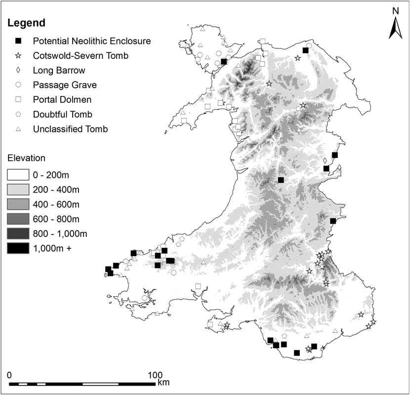
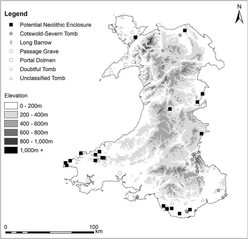
Given the uncertainty about which sites do possess Neolithic origins, it is perhaps prudent at this stage not to make too many generalised statements about their location and topographic setting. However, it is noticeable that the potential Neolithic enclosures in Wales appear to cluster in three key areas: the Vale of Glamorgan, Pembrokeshire and the Upper Severn Valley. These areas also contain dense concentrations of Neolithic burial monuments, suggesting they were the focus for Early Neolithic populations. The association of causewayed enclosures with tombs has long been notedFootnote 90 and argued as an important factor in their siting.Footnote 91 However, concentrations of burial monuments are conspicuous in several regions of Wales, such as Gwent, Gower, the Black Mountains, the Llyn peninsula, Anglesey and the North Wales coast, where confirmed enclosures have so far not been located (fig 10). While some regions of England, such as the areas around the Humber estuary, possess dense concentrations of burial monuments and few causewayed enclosures,Footnote 92 targeted research in these regions of Wales could yield significant new information about the spread of the Neolithic into the western parts of Britain.
A comparison of the distribution of potential Early Neolithic enclosures and burial monuments
The evidence from Caerau suggests that the Neolithic of Wales can be both rich and informative, and it is to be hoped that more sites like this will be discovered in the not too distant future.
ACKNOWLEDGEMENTS
The authors would like to express their thanks to the Cambrian Archaeological Association, which generously provided a grant for the dating of the radiocarbon samples. Funding for the excavations at Caerau was provided by the Arts and Humanities Research Council and the University of Cardiff, for which support the authors are extremely grateful. The authors would also like to thank Julian Thomas and Tim Darvill, who kindly provided access to unpublished material. Toby Driver provided information about many of the cropmark discoveries and the authors are extremely grateful for his help. Initial assessment of the polished axes was undertaken by Jana Horuk (National Museum Wales), while Peter Bye-Jensen undertook primary use-wear analysis of the flint assemblage – the authors are very grateful to both individuals for this.
SUPPLEMENTARY MATERIAL
To view supplementary material for this article, please visit https://doi.org/10.1017/S0003581517000282.
ABBREVIATIONS AND BIBLIOGRAPHY
Abbreviations
- BAR
-
British Archaeological Reports, Oxford
- HMSO
-
Her Majesty’s Stationery Office, London
- RCAHMW
-
Royal Commission on the Ancient and Historical Monuments of Wales