INTRODUCTION
Modular grids composed of perpendicular roads forming blocks were unknown in pre-Columbian Maya settlements until the remapping of Nixtun-Ch'ich’ in the Department of Peten, Guatemala (Pugh and Rice Reference Pugh and Rice2017). Nixtun-Ch'ich’ was the largest Middle Preclassic period (800–400/300 b.c.) settlement on Lake Peten Itza, and was likely the capital of an early polity. The city stands on the western lakeshore between karstic hills to the north and a narrow arm of the lake to the south (Figures 1 and 2). Covering an area of approximately 2.5 km2 with an compact urban core of 1.1 km2, the site occupies a low ridge sloping from west to east and from its central axis to the north and south. Nixtun-Ch'ich’ differs from other Maya sites in having a modular urban grid constructed during the Middle Preclassic period (Table 1; Pugh and Rice Reference Pugh and Rice2017). Major construction continued during the Late Preclassic (400 b.c.–a.d. 200) period, but the site was largely abandoned immediately afterwards (Pugh Reference Pugh2018). Moderate occupation resumed during the Late/Terminal Classic (a.d. 600–900), and continued into the Postclassic (a.d. 900–1525), (Spanish) Contact (a.d. 1525–1697), and Colonial (a.d. 1697–1820) periods (Pugh et al. Reference Pugh, Rice, Nieto and Rice2016b).
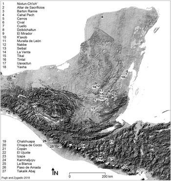
The Maya region, with select Preclassic-period sites. Map by Pugh and Zygadło.

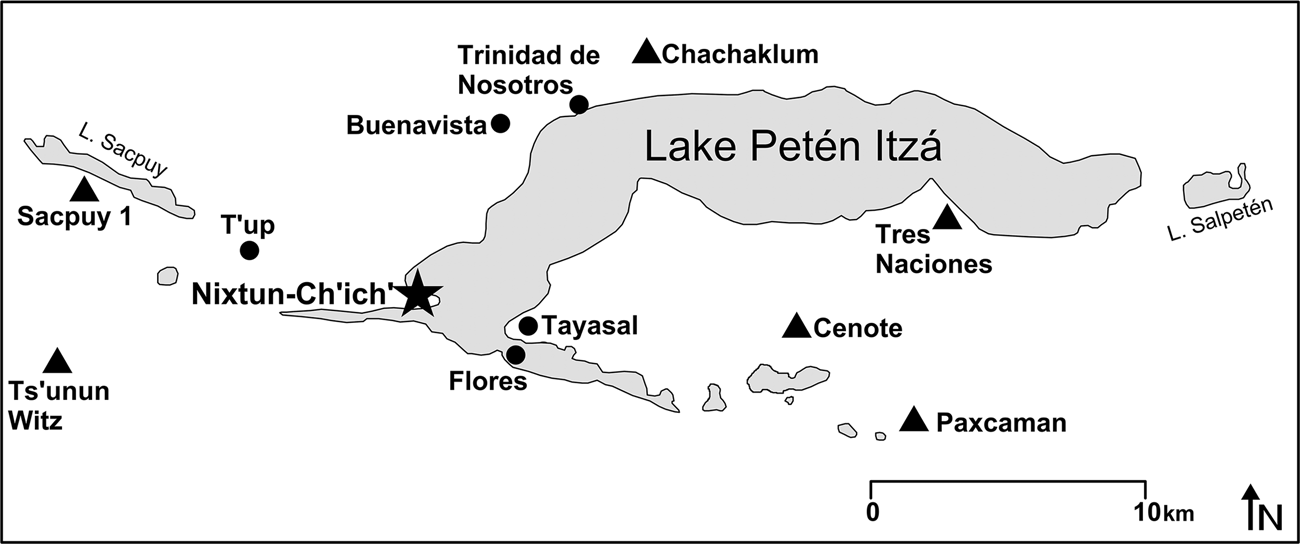
Lake Peten Itza with Middle Preclassic sites near Nixtun-Ch'ich’. Triangles mark sites with E-Groups and circles identify smaller, Middle Preclassic-period settlements. Image by Pugh.

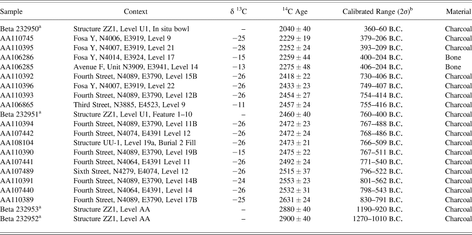
Preclassic-period radiocarbon dates from Nixtun-Ch'ich’.

a Rice Reference Rice2009:Tables 2 and 3.
b Dates calibrated with OxCal. 4.2.
Middle Preclassic Nixtun-Ch'ich’ seems to have been built according to a preplanned diagram (Pugh and Rice Reference Pugh and Rice2017:585; Rice Reference Rice2018). Recent work, presented here, has revealed that the site's axis urbis was much larger than recorded by earlier work. Thus, planning at the site was even more elaborate than previously suggested. The fact that the grid and axis were regulated for a several hundred years suggests that they were key elements of life in the city. Given the amount of planning involved in this city, one would expect that sites under its sphere of control would also have been built according to the same or a similar diagram or imitated it. Thus, it is not surprising that our new survey encountered a second smaller gridded site, T'up, near Nixtun-Ch'ich’ that appears to have been its satellite. Here we investigate evidence of societal complexity at Nixtun-Ch'ich’ especially planning within the site and the relationship between Nixtun-Ch'ich’ and nearby settlements. We argue that the site and the polity that it headed were more cooperative in their organization during the Middle Preclassic period.
COLLABORATIVE STRATEGIES, AND PUBLIC GOODS
Complex societies include large populations, internal diversity, social inequality and strong ideological binding (Tainter Reference Tainter1988:23). Nixtun-Ch'ich’ exhibits these and other diagnostics of complexity, including centralized urban planning and labor organization, a settlement hierarchy, and possibly specialization and standardized architectural styles. We often imagine leadership in incipient states to involve central rulers whose legitimacy is heavily broadcast and whose power is based upon coercion. Yet not all early societies were organized in a competitive manner. Many were more collaborative societies and, contrary to general thinking, were actually more complex because they involved layers of support personnel (bureaucracies) that maintained public goods (Blanton and Fargher Reference Blanton and Fargher2011:506–507). Such societies and their cities tended to be larger and more stable (Feinman and Carballo Reference Feinman and Carballo2018:10–13). Collaborative societies generally regulated the ambitions of elites through extensive bureaucracies. They had greater social mobility, decentralized power, and lacked a rigid administrative chain of command (Blanton Reference Blanton, Feinman and Marcus1998). Most were “faceless” (no or few representations of rulers) and lacked exaggerated mortuary differentiation. Instead, they often focused upon “collective representation” and social/cosmic renewal (Blanton Reference Blanton, Feinman and Marcus1998:150; Feinman and Carballo Reference Feinman and Carballo2018:10–11).
Collaborative societies emphasize public goods. In order to develop properly and apply public goods, rulers must understand the societies that they rule. Infrastructural power includes strategies that rulers use to penetrate, comprehend, and manage their societies. Such power is generally more intense in collaborative societies (Blanton and Fargher Reference Blanton and Fargher2011:507). Simple surveillance is one way to accomplish these goals, but good surveillance requires that watchers are trusted and the population does not keep secrets. Thus, strategies also develop that ease the burden of surveillance—to enhance the legibility of society. Legibility includes strategies to make the population readily readable and knowable such as personal identification numbers, street addresses, surnames, and urban planning (Scott Reference Scott1998) as well as writing, record keeping, state languages, and standardized calendars, laws, currencies, weights, and measurements (Yoffee Reference Yoffee2005:92–112). These various strategies permit political elites both access and economic resources to manage their constituents better. Planned elements such as urban grids have long been employed as governing tools (Rose-Redwood Reference Rose-Redwood2006; Scott Reference Scott1998).
Scott (Reference Scott1998) examined centralized efforts at legibility and argued that they forcefully displace existing local systems of legibility. They “rationalize” the system from above, rather than from the bottom-up (Rose-Redwood Reference Rose-Redwood2006:75–83; Scott Reference Scott1998:69). Of course, archaeologists are not strangers to the managerial efficacy of a precisely established grid as we use them to control our excavations (Rose-Redwood Reference Rose-Redwood2006:84–91). Yet we must avoid getting mired in a dystopian critique if we are to comprehend ancient urban planning. Legibility has many positive qualities—street addresses, surnames, and planning can be used by and empower all members of society, not just elites. Furthermore, elites also exist within the rationalized milieu—once it is put into place, they no longer stand above it, but within it.
Many public goods such as public spaces, centralized sewer and water systems, and defensive walls require planning and are generally meant to improve communities. Grids facilitate the comprehension and use of space, thereby enhancing social interactions. The same is true of landmarks, street addresses, road signs, and maps. Enhancing movement economy is a common characteristic of more collaborative societies (Blanton and Fargher Reference Blanton and Fargher2011:509–512). In general, more cooperative societies tend to invest more in “knowing themselves” and improving (Foucault Reference Foucault, Burchell, Gordon and Miller1991:102–103).
Besides enhancing social interaction, urban grids can have a number of other benefits. First, they are easier to understand by outsiders who might be confused by local, more organic layouts (Scott Reference Scott1998:53–55). Thus, easily readable cities were likely more attractive to occupants of peripheral settlements. Urban form along with other spatial attributes can produce a distinguishable atmosphere, leading to “topophilia” (Tuan Reference Tuan1990:4) or “place attachment” (Low and Altman Reference Low, Altman, Altman and Low1992:2) which both refer to “the bonding of people to places.” Place attachments involves not just a particular place, such as a home or a community, but also a particular style of place. People feel safe and can more easily understand and bond with spaces with forms similar to earlier place attachments. Constructing places in a familiar style also enhances their legibility.
As with other styles, those affecting place attachment can augment social identity. Political elites often do not strive to maintain diversity, but instead standardize social patterns in order to create common identities and enhance political integration (Foucault Reference Foucault, Burchell, Gordon and Miller1991:87–104; Levene Reference Levene2000). Geometry and spatial organization can act as “symbols of cultural commonality” (Yoffee Reference Yoffee2005:33–37) that unite residents and differentiate them from those who construct space in a different way. Consequently, planners may standardize space to meld the emotional impact of place attachment with the polity. Such standardization may decrease the strength of factional identities and, therefore, segmentation and internal competition. Factions within cities, however, may resist centralization and strive to maintain neighborhood boundaries (Jennings and Earle Reference Jennings and Earle2016:476).
Not all road systems are the same, and it is useful in the current context to consider focal and nonfocal road systems. Focal systems are those that emphasize a particular feature, such as a town square or central monument with most central roads leading to that point. On the other side of the continuum are nonfocal road systems that do not emphasize particular locations, such as modular grids. Such systems are good for the larger population and are relatively democratic (Walker Reference Walker2011:168). Nevertheless, some grids, such as polar grids, can emphasize a particular point. Emphasis can occur within a modular grid by making some roads wider, constructing them with better quality, and using them for special events, such as parades and protests. Furthermore, buildings can be emphasized outside of the context of the road system through the use of height and decoration.
In sum, public goods such as drainage/sewer, water, and road systems are often centrally planned to improve city life. Some planning—including gridded street systems—enhances the legibility of the city and its occupants. Elites can utilize legibility to comprehend society to improve and/or control it. The imposition of centralized planning disrupts local systems of organization. On the other hand, legibility can enhance the social experience of the entire population. Finally, systems that invest heavily in public goods tend to be far more collective in their organization.
PUBLIC GOODS AND THE PRECLASSIC PERIOD
At the beginning of the Middle Preclassic period, sedentary populations in Peten, Guatemala, interacted with mobile foragers. Groups following these varied subsistence and settlement strategies seem to have focused upon the same ceremonial areas and may have ultimately melded to form larger communities (Inomata et al. Reference Inomata, MacLellan, Triadan, Munson, Burham, Aoyama, Nasu, Pinzóne and Yonenobu2015:4273). Cities and states formed in many areas over the course of the Middle Preclassic period (Hansen Reference Hansen, Traxler and Sharer2016:360–381). Middle Preclassic Maya sites tend to be more collaborative than those of the Late Preclassic and Classic-period Maya, whose more competitive social system differs from most of Mesoamerica (Feinman and Carballo Reference Feinman and Carballo2018:11; Feinman and Nicholas Reference Feinman, Nicholas, Charlotte Arnauld, Manzanilla and Smith2012).
Many Middle Preclassic period Maya sites include public goods such as causeways, monumental architecture, reservoirs, dams, and canals (Hansen Reference Hansen, Traxler and Sharer2016:347–351). Most ancient Maya cities tended to be focal as primary road systems generally led to monumental groups (Shaw Reference Shaw2001:262). The causeways of many linked outlying groups to the center forming a dispersed dendritic pattern. Intersite causeways connected the major sites and enhanced social interactions in the Mirador Basin (Hansen Reference Hansen, Traxler and Sharer2016:369). East-west axes are typical of lowland Maya sites of the Preclassic period and contrast with the north-south axes of the adjacent Olmec, Chiapas, and Tabasco regions (Estrada-Belli Reference Estrada-Belli2011:67; Hansen Reference Hansen, Traxler and Sharer2016:347; Inomata et al. Reference Inomata, Triadan, Liendo Stuardo, Castillo, Méndez Bauer and Vázquez López2018).
The Late Preclassic- and Classic-period Maya also exhibit dendritic settlements, with a number of ceremonial cores connected by causeways. Interspersed residential clusters, some of which were organized around “neighbourhood civic-ceremonial groups,” surrounded the cores (Isendahl and Smith Reference Isendahl and Smith2013:132–134). The low density of Maya communities has led to their being classified as “green” cities because some agricultural production existed within them rather than being relegated to the outside (Drennan Reference Drennan and Wilk1988; Graham Reference Graham1999:186). The dispersed layouts, however, were also likely the result of social patterns in Maya society (Feinman and Nicholas Reference Feinman, Nicholas, Charlotte Arnauld, Manzanilla and Smith2012:148).
Preclassic Maya sites include monumental architecture, often in ceremonial assemblages, such as triadic groups and E-Groups. Triadic groups are large platforms capped by three temples that may represent the typical three-stone hearth of the Maya creation story (Hansen Reference Hansen and Houston1998:77–81). E-Groups include two buildings: a roughly square building to the west and a long, low structure to the east. The western structure is often radial, with stairways to the cardinal directions and the long eastern building has three superstructures, one to the north, south, and center (Blom Reference Blom1924; Ricketson and Ricketson Reference Ricketson and Ricketson1937). E-Groups occur very early at some sites and tend to be earlier than triadic groups (Estrada-Belli Reference Estrada-Belli2011:75; Inomata et al. Reference Inomata, MacLellan, Triadan, Munson, Burham, Aoyama, Nasu, Pinzóne and Yonenobu2015:4269). While the construction of these assemblages began in the Middle Preclassic period, it continued in the Late Preclassic and early Classic periods. One E-Group may have been constructed in the Early Postclassic period (Aimers and Rice Reference Aimers and Rice2006:79–80).
E-Groups are well-known as astronomical groups or solar observatories (Freidel et al. Reference Freidel, Chase, Dowd and Murdock2017), though some would not have accurately fulfilled this function. They also likely served as ritual “stages” for calendrical and political rites (Aimers and Rice Reference Aimers and Rice2006:93). As succinctly stated by Doyle (Reference Doyle2012:369), “E-Groups could perhaps be the earliest examples of a Maya civic requirement for sociopolitical units, a space and monumental architectural formation necessary for settlers to interact with one another.” Given their calendrical, political, and social functions, it is very possible that they also served as administrative centers.
Planned water-control systems were another innovation of the Preclassic Maya, though they are better known from the Late Preclassic period and later. Such water systems involved reservoirs, dams, dikes, conduits, canals, and aqueducts (Kaplan and Paredes Umaña 2018:264–286; Scarborough Reference Scarborough2003:112–115). Middle Preclassic water control also existed among the Maya (Hansen Reference Hansen, Traxler and Sharer2016:351). Some reservoirs were built adjacent to Middle Preclassic E-Groups (Reese-Taylor Reference Reese-Taylor, Freidel, Chase, Dowd and Murdock2017:485). The water systems might reflect influence from the Olmec, as water systems exist at San Lorenzo and other sites (Cyphers Reference Cyphers, Grove and Joyce1999).
NIXTUN-CH'ICH’
Middle Preclassic-period Nixtun-Ch'ich’ invested heavily in public goods, such as its gridded streets which doubled as a drainage system. We have also identified several circular features lined with stones—some if not all of these constructions were reservoirs. The city's planners designed an elongated axis urbis as a foundation point for the grid. Yet, these planners remain anonymous, unheralded by self-aggrandizing monumentality. Thus, Nixtun-Ch'ich’ appears have had a more cooperative social system. While the city's streets and buildings changed over time, the grid was regulated until the end of the Late Preclassic period (Pugh Reference Pugh2018).
In 2017, previously unmapped portions of Nixtun-Ch'ich’ were drone-surveyed, producing georeferenced images that we merged to create a digital elevation model with photogrammetry. The new site plan (Figure 3) revealed at least 21 buildings and two reservoirs aligned to form the city's east-west axis urbis, which the new measurements indicate was oriented 94°40′ over the bedrock ridge underlying the site. The axis of Nixtun-Ch'ich’ is exceptionally elongated: 1,780 m long within the site core and stretching to 3,050 m if we include a large platform (Structure ZZ1) at the eastern tip of the Candelaria Peninsula.
Nixtun-Ch'ich’, Peten, Guatemala. Image by Pugh and Zygadło.

Whereas the straight lines and right angles of the grid might be the most striking features on the site plan, the axis urbis stands out to pedestrians on the ground. It would have oriented the residents and accentuated the importance of the high buildings occupying its elevated terrain. The axis urbis inspired awe and a sense of stability, as it continues to do so. It certainly dominated the Preclassic-period cityscape (Booth Reference Booth2012:21).
We do not know the function of all of the constructions on this axis urbis, but most were ceremonial, especially in central Sectors Y, Z, AA, and BB (Figure 4), which we consider the civic-ceremonial nucleus of the site. The axis is grounded on the east side of this nucleus by a large “triadic group” platform (Structure BB1), a typical location for these assemblages (Estrada-Belli Reference Estrada-Belli, Traxler and Sharer2016:257). The triadic group visible in Sector BB1, however, was built during the Late Preclassic period. While a large Middle Preclassic temple stood in this location, it may not have been part of a triadic group.
Gridded core of Nixtun-Ch'ich’. Image by Pugh.

There is nothing subtle about the urban planning of Nixtun-Ch'ich’ (Figure 4). Its grid consists of at least 45 constructional sectors or blocks formed by intersecting corridors identified as six east-west “streets” and seven north-south “avenues” (Pugh and Rice Reference Pugh and Rice2017:581). The streets of Nixtun-Ch'ich’ differ from most Maya causeways, which are “focal” and link specific places, whether cities or architectural groups (Shaw Reference Shaw2001:262). In contrast, the streets and avenues of Nixtun-Ch'ich’ are nonfocal and do not tend to privilege particular locations with respect to pedestrian movement (Pugh Reference Pugh2018).
The gridded urban core extends beyond Structure BB1 to the east ending with another planned element—a large north-to-south “defensive” wall and ditch that separates the eastern end of the peninsula from the rest of the site (Figure 3; Rice Reference Rice2009:403–405). The wall rises 6.2 m higher than the base of the ditch to its west (Figure 5). Yet, it stands only 2.1 m higher than the terrain to its east, and the slope to the west is dramatically steeper. The western side of the wall is formed by a series of coursed rubble terraces. At the top of the wall is a 4-m wide platform, which is oriented 3.5° west of north, though it is not completely straight. The width of the ditch varies, but is generally around 15 meters wide and two meters deep. Its lowest terrace was sculpted into soft limestone bedrock or perhaps fool's bedrock, which is thick fill composed of pulverized limestone that is often mistaken for bedrock (Brown et al. Reference Brown, Jennifer Cochran and Mixter2011:212). The current ground surface of the ditch stands 2 to 3.7 meters higher than the current lake level, so it could have been a canal, though this prospect remains untested. The wall and ditch do not seem to cover the southern 100 m of the peninsula unless this area, currently occupied by a farmhouse, was heavily disturbed by modern construction.
Cross section of the wall of Nixtun-Ch'ich’. Image by Pugh.

The wall and ditch are puzzling, as their defensive side faces to the west, toward the main body and gridded portion of the site (Rice Reference Rice2009:403). The steep western side accentuated by the ditch makes movement from the west to east across the wall very difficult—even now when covered by soil. It would have been even more formidable when the vertical walls were exposed and particularly if defended by warriors armed with spears and stones. Thus, the orientation of the wall seems counterintuitive if one considers it a defensive feature for Nixtun-Ch'ich’ proper. While it certainly looks like a defensive feature, it could have been another avenue in the grid—though an odd one. Alternatively, it might have been a canal or other hydraulic feature—a widened area in the southern part of the ditch could have been a reservoir. Another possibility is that it was defensive and the area to the east was a section of the city vehemently separated from the rest such as a royal and/or sacred district.
A final prospect is that the area east of the wall might have been controlled by a social group at odds with Nixtun-Ch'ich’, perhaps the occupants of Tayasal. A similar wall-and-ditch feature stands at Tayasal north of the cenote of San Miguel. Conceivably, this hypothetical hostile group could have built the wall to defend the end of the peninsula, perhaps Structure ZZ1, from Nixtun-Ch'ich’ proper.
The site continues approximately 180 meters to the east of the wall, which then largely terminates until one reaches Structure ZZ1 at the eastern end of the peninsula (Figure 3). Structure ZZ1 was a ceremonial building with use beginning by 1000 b.c., the start of Maya occupation in Peten, predating the grid (Table 1; Rice Reference Rice2009). This mound, with a nearly 360° view of the western Lake Peten Itza basin, may have been an early observation point and pilgrimage center. We have not, however discerned domestic areas within a few hundred meters from this large mound. In fact, Structure ZZ1 might be considered a separate site if it did not rest roughly on the site's axis urbis.
Immediately west of the triadic group (BB1) lies an E-Group (Sector AA; Figure 4) and another E-Group (Sector A) bounds the westernmost side of the central axis (Figure 3). These locations are typical of E-Groups (Estrada-Belli Reference Estrada-Belli, Traxler and Sharer2016:257).
A third E-Group, in Sector Y in the middle of the ceremonial core stands to the west of a 46-m-wide sinkhole, Fosa Y (Figure 4). Much of this E-Group was built during the Late Preclassic period and, while we know it had a Middle Preclassic-period antecedent, we are uncertain of the layout of the earlier group. Given the possibility that E-Groups had administrative functions, the three groups at Nixtun-Ch'ich’ could have centered districts within the city (Pugh Reference Pugh2018).
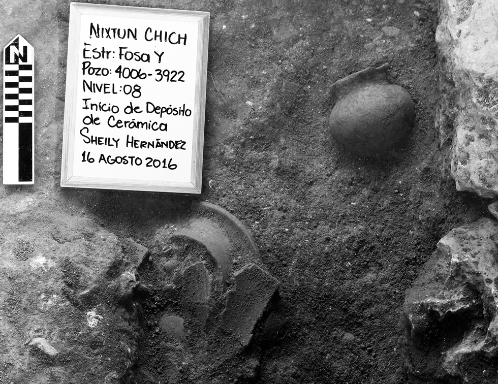
Excavations into Fosa Y revealed amphitheater-like stone terraces composed of large limestone rubble. A 40-cm thick deposit of ritual refuse including large sherds of reconstructable vessels (Middle Preclassic period; Figure 6), fauna, and various other artifacts covered the terraces (Rice and Pugh Reference Rice and Pugh2017; Rice et al. Reference Rice, Pugh and Nieto2019). Many of the objects, including the ceramics and a jade mask fragment, mentioned below, had been purposefully destroyed. Radiocarbon assays date the deposit to the end of the Middle Preclassic period (Table 1). Beneath the fill supporting the terraces were layers of clay, suggesting that the fossa may have once contained water. We excavated four meters of this clay, below the terraces, without reaching bedrock, though we did encounter a cache with a large plate containing part of a human skull. The fossa was also used in the Late Preclassic period, when two polished manos and several limestone disks, likely beehive covers, were deposited (Rice et al. Reference Rice, Pugh and Nieto2019).
Ceramic sherds in Fosa Y, Nixtun-Ch'ich’. Photograph by Sheily Hernandez.

Fosa Y is thought to have centered the city's axis urbis (Figure 3; Rice and Pugh Reference Rice and Pugh2017). Fosa Y is one of two reservoirs on the central axis, although it does not currently hold water. Fosa V to the west still fills each year during the rainy season (June–December) and gradually desiccates during the dry season (January–May). Thus, whether intentional or not, it acts as a seasonal calendar. Several other waterholes lie elsewhere in the site, some of which fill annually. One dry fossa in Sector Q is contemporary with Fosa Y and may have had related social functions, as it was also surrounded by stone terraces.
Recent work at the southern end of Avenue G (Figure 3) revealed another massive deposit of “killed” late Middle Preclassic ceramics and other valued goods as well as faunal refuse. Thus, the deposit in Fosa Y was not unique, but part of a larger as yet poorly understood pattern at the site. Termination events including the destruction and deposition of ceramic vessels and other objects, however, are common in the Maya area and can signify calendric endings/beginnings (Walker Reference Walker and Mock1998:95–97). While the majority of the site's constructed mass is Middle Preclassic, a massive construction event occurred at the onset of the Late Preclassic period. If the construction occurred along with the termination events, then these deposits may have signaled a new social order—perhaps a different form of leadership.
The presence of large quantities of fauna refuse in both termination deposits and beehive plugs in Fosa Y suggests that this event also involved feasting. Large feasts are a common means of creating social cohesion, but they also allow for the construction of social inequality (Dietler Reference Dietler, Dietler and Hayden2001:74). They additionally might have acted as a “work feast” (Dietler and Herbich Reference Dietler, Herbich, Dietler and Hayden2001) that helped draw people together for the extensive Late Preclassic constructions at Nixtun-Ch'ich’.
Massive construction projects require technological knowledge and organization. In Europe, before the alignment of construction with formal mathematics, architecture was composed and organized by masons rather than formally trained architects (Wolfe Reference Wolfe2009:111–152). This was likely also the case with the Maya. Masonry appears to have become a specialized occupation at El Mirador by the end of the Middle Preclassic period (Hansen Reference Hansen and Houston1998:71–105). Given the complex planning, orientations, and amount of building material required of the urban grid at Nixtun-Ch'ich’, masonry also appears to develop as a specialized occupation there sometime between 800 and 500 b.c. The degree of involvement of political elites in this process is unknown, but they must have participated in the initial design of the site layout as the novel form would have required a certain amount of consent from the population.
The dense population, urban grid, large amounts of public space (the streets), and legibility of Nixtun-Ch'ich’ suggest a relatively prosocial or collaborative social system (Blanton and Fargher Reference Blanton and Fargher2011). The percentage of space dedicated to streets, however, decreased from their initial establishment to the end of the Late Preclassic period, suggesting a shift toward a more competitive social system. This trend likely relates to heightened social inequality and less emphasis upon the public good (Pugh Reference Pugh2018).
FACELESSNESS
The concept of “kingship” is often used as a means to evade the difficulties inherent in contemplating societal complexity (Martin Reference Martin, Traxler and Sharer2016:540). Yet, scholars concentrating on kingship seem less focused on rulership than on the legitimacy and unification of a polity by contriving the ruler as a centralizing symbol. Indicators of such ruler cults or personality cults, like those in Hellenistic Greece or the former Soviet Union, can be found in monuments/statuary and rites that commemorate and make central the deeds, lives, power, and divine connections of the ruler. Such monuments should be omnipresent, and their meanings made clear to the public eye if they are to act as effective amalgamators (Kruk Reference Kruk2008:28–41).
In our survey and excavations, we have not yet identified evidence of exalted rulership. This is not to say that Middle Preclassic Nixtun-Ch'ich’ lacked leaders: someone, an individual or group, must have had considerable vision and authority to plan the axis and grid, and organize the massive labor, possibly from outlying communities, to build it. It is quite possible that they, like later rulers, possessed the title ahaw (Martin Reference Martin, Traxler and Sharer2016:523–534). To date, however, we have no physical remains or images of such leaders.
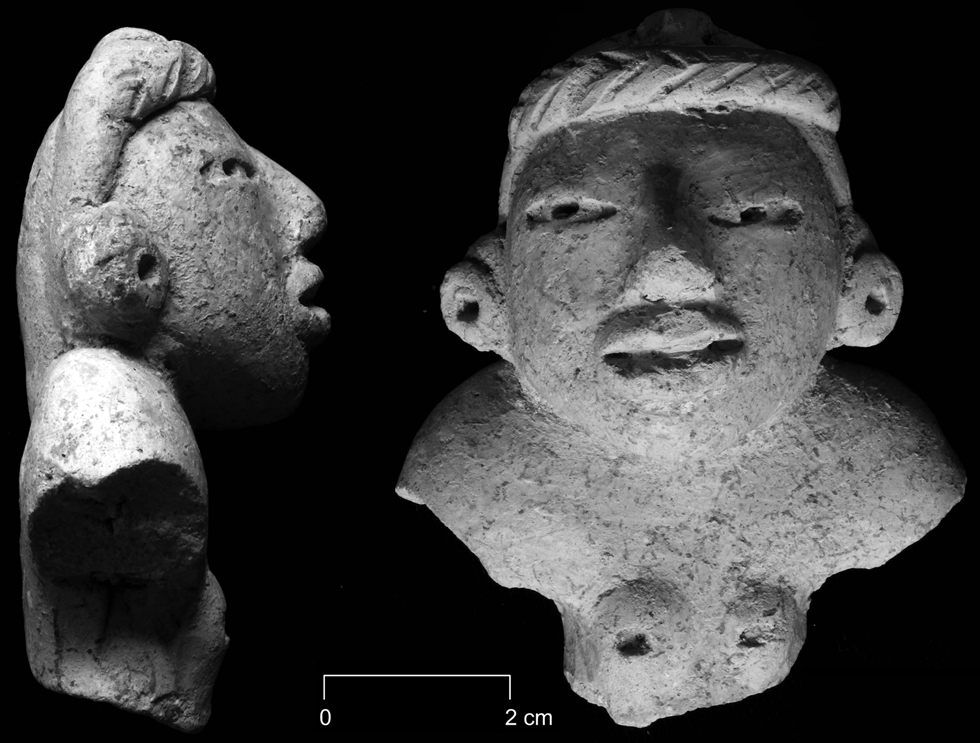
Fired-clay Middle Preclassic figurines, which are common at Nixtun-Ch'ich’ reveal that iconoclasm was not an issue, and they were artistically refined. These figurines do not appear to represent rulers (Figure 7) and certainly do not evoke a personality cult similar to many Classic-period monuments, which propagandize the ruler as a central symbol of unity and power. Rulers are depicted on such monuments carrying out rituals, laden with jewelry, costumes, and symbols of divinity; they are buried in elaborate tombs accompanied by wealth in the form of painted pottery, jades, and other exotic goods. The cult of the ruler in Classic times was enhanced by the presence of written texts, which focus on parentage and dynastic achievements. Middle Preclassic Nixtun-Ch'ich’, on the other hand, tended to emphasis images of fertility and cosmic and social renewal (Rice Reference Rice2015:31)—it was faceless.
Middle Preclassic Period figurine fragment from Nixtun-Ch'ich’. Photograph by Pugh.

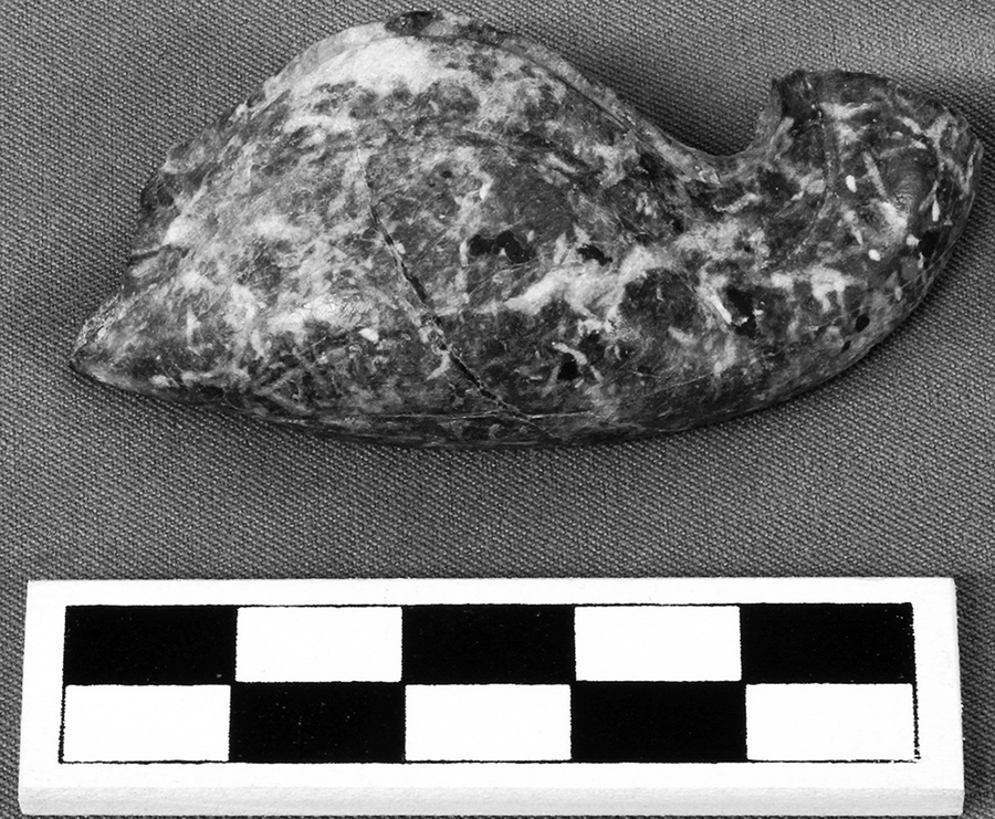
The style of the figurines at Nixtun-Ch'ich’ suggest interregional interaction (Rice Reference Rice2015). We have also found evidence for the import of obsidian, greenstone, and marine shell at Middle Preclassic Nixtun-Ch'ich’. One object, the mandible of a broken jade mask (Figure 8) in a Middle Preclassic context, seems Olmec in style (John Clark, personal communication 2018). We do not know if the mask arrived complete or as a fragment, or the specifics of exchange. Such masks were valued as inalienable objects among the Olmecs and were frequently broken and the pieces redistributed (Clark and Colman Reference Clark and Colman2014:23–24). Thus, it is possible that the fragment found its way to Nixtun-Ch'ich’ because of relations with the Olmecs or, more likely, with another group in contact with the Gulf Coast cultures
Olmec-style mask fragment from Nixtun-Ch'ich’. Photograph by Pugh.

HIERARCHY
Many archaeologists consider settlement hierarchies as prime indicators of societal complexity (Flannery Reference Flannery, Feinman and Marcus1998:16–21; Marcus Reference Marcus1973; Wright and Johnson Reference Wright and Johnson1975). Such hierarchies are generally defined by site sizes and positions with lower-level settlements tending to girdle those higher in the hierarchy. States, for example, are generally characterized as having four levels in the hierarchy, though this is not an absolute rule as there is considerable variability in the category “states” (Flannery Reference Flannery, Feinman and Marcus1998:16). Another type of hierarchy in states is the “decision-making hierarchy,” which tends to have “two to three (or more)” levels (Marcus and Feinman Reference Marcus, Feinman, Feinman and Marcus1998:6). While evidence of administrators is generally absent when written texts do not identify them, we can find “administrative institutions,” such as palaces and “standardized temples” (Flannery Reference Flannery, Feinman and Marcus1998:16–36).
Middle Preclassic deposits have been found beneath many large excavated sites on or near Lake Peten Itza such as Flores (Gaméz Reference Gámez, Laporte, Arroyo and Mejía2007:259–261), Trinidad de Nosotros, Buenavista-Nuevo San Jose, Motul de San Jose (Castellanos and Foias Reference Castellanos and Foias2017; Moriarty Reference Moriarty, Foias and Emery2012:205–206), Tayasal (Pugh et al. Reference Pugh, Miller, Freiwald and Rice2016a:54), Ixlu (Rice Reference Rice2015:8), and Zacpeten (Pugh and Rice Reference Pugh, Rice, Rice and Rice2009:95–97). Yet these sites are covered with substantial later constructions obscuring the constructions and preventing easy access, making it difficult to connect them with Nixtun-Ch'ich’. One newly identified site, T'up, is a satellite of Nixtun-Ch'ich’ that is not concealed by later construction.
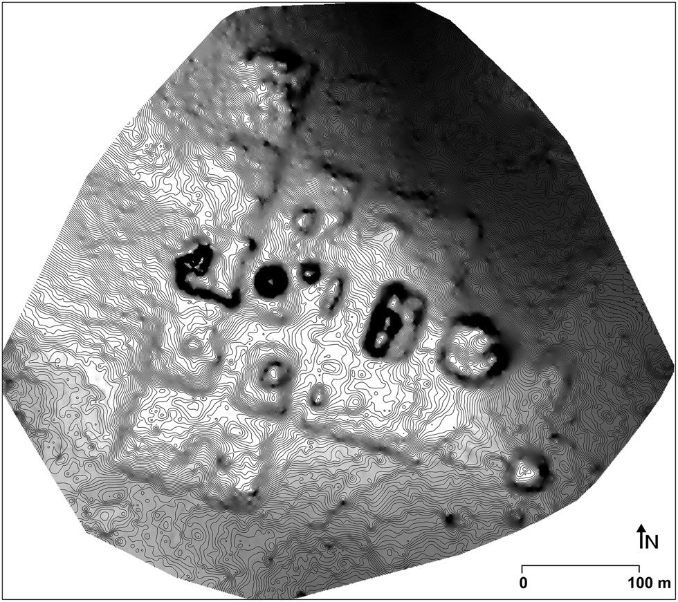
T'up lies 4.8 km northwest of Nixtun-Ch'ich’ and about 0.5 kilometers east of Lake Sacpuy. It was recently surveyed by a drone and mapped using photogrammetry (Figure 9). T'up seems to mimic the unique symmetrical, gridded architectural style of Nixtun-Ch'ich’. The site core, measuring 0.13 km2, comprises a grid of at least 13 blocks forming a stepped shape. The grid is composed of four north-south and four east-west corridors, but T'up has not yet been excavated to ascertain if these were constructed as formal streets like those at Nixtun-Ch'ich’. A 385-m-long row of at least five buildings/platforms constitutes an axis urbis oriented approximately 108° east of north. The site was symmetrically constructed along the axis, although the northern side seems to have been damaged by erosion. It had at least one central temple that stood on the western side of the axis. Unfortunately, our photogrammetry survey revealed that this building has been nearly completely destroyed for road construction fill.
T'up, Peten, Guatemala. Image by Pugh and Zygadło.

T'up's east-west axis is a common characteristic of the lowland Maya Preclassic period, but its gridded blocks are unknown outside of Nixtun-Ch'ich’. Thus, T'up emulated the geometry and, therefore, the spatial ideology of Nixtun-Ch'ich’. As a minor ceremonial center displaying the unique architectural style of Nixtun-Ch'ich’, T'up seems to have been a satellite or suburb of the larger site. What is more, T'up is oriented with its central axis pointing toward Nixtun-Ch'ich’ (to the area of Structure BB1) as well as the central portion of Tayasal. Neither site would have been visible from T'up, as karstic hills stand to its east. It is possible that the alignment was happenstance, but one wonders if the builders of this site intended to point it toward Nixtun-Ch'ich’. If so, just as the axis urbis dominated the architecture of T'up, the location of Nixtun-Ch'ich’ dominated/guided the orientation of the axis (Booth Reference Booth2012:21). The axis urbis of Nixtun-Ch'ich’ appears to have been aligned with and, therefore, venerated, sunrise. Thus, if the planners of T'up chose to orient its axis toward Nixtun-Ch'ich’ rather than sunrise, which would obviously have been visible from T'up, this would imply reverence for the larger site and, therefore, hierarchy.
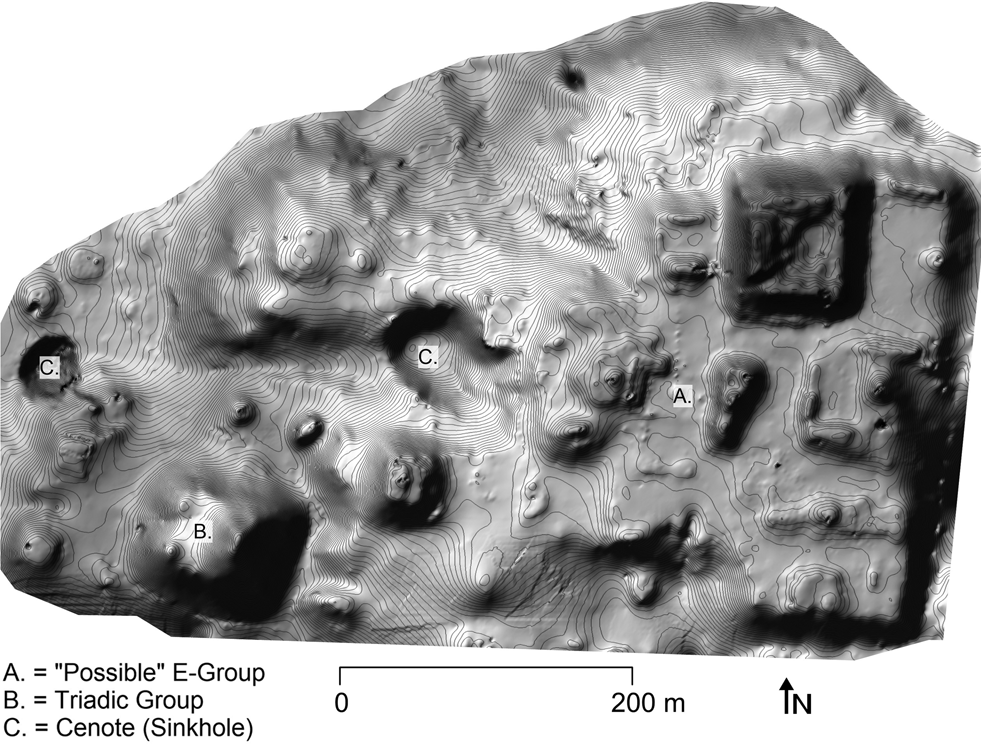
Tayasal was also likely a minor center during the Middle Preclassic period. While it has a “possible” E-Group (Chase Reference Chase1983:Table 44), the western building in the group is a bit small, and two of the three buildings on the eastern structure were likely constructed during the Postclassic period. Our excavations at Tayasal revealed Middle Preclassic deposits beneath an 8-m high, 270-m long, and 300-m wide stepped-shaped platform (Figure 10). The platform is oriented 99.5°/279.5° and does not appear to “point” toward Nixtun-Ch'ich’, but rather just south of the site. Middle Preclassic constructions are rare elsewhere at Tayasal. The platform was also extensively modified during the Late Preclassic period, during which it received the majority of its mass (Pugh et al. Reference Pugh, Sánchez and Shiratori2012:8). Middle Preclassic antecedents, however, were found in all units excavated to bedrock. The platform is slightly smaller than T'up and we have not identified a grid at Tayasal, but it has a very similar stepped footprint.
The central platform, Tayasal, Peten, Guatemala. Image by Pugh.

A vague east-west axis urbis bisects the Tayasal platform, but Late Preclassic, Early and Late Classic, and Postclassic constructions obscure Middle Preclassic patterns on the platform. Immediately west of the vague central axis urbis stands a large cenote. An east-to-west road leads from this cenote to a second cenote. While this road is not perfectly aligned with the large platform, it seems to be part of the axis urbis. Tayasal was a small community during the Middle Preclassic period, but it grew to be a major center with two triadic groups during the Late Preclassic period—possibly challenging Nixtun-Ch'ich’.
The Early Classic component of Tayasal was smaller than its Late Preclassic component but still much larger than Early Classic Nixtun-Ch'ich’. One Early Classic-period burial found in Structure T110 at Tayasal likely contained a noble and was more sumptuous than any other burial thus far encountered at a site on Lake Peten Itza (Chase Reference Chase1983:401–423). Fragmented Early Classic Tayasal Stela 3, found 130 m west of Structure T110, depicts a standing person and may relate to the Ik'a' lords, who eventually ruled Motul de San Jose (Tokovinine and Zender Reference Tokovinine, Zender, Foias and Emery2012:36). The tomb and the monument signal the arrival of a more competitive social system and a cult of rulership to the western portion of Lake Peten Itza. We observe an earlier emergence of this sort of rulership at Tikal, where a dynasty was established at around a.d. 100 (Freidel and Schele Reference Freidel and Schele1988:552; Martin and Grube Reference Martin and Grube2008:26).
Small groupings of buildings are visible on the site plan to the north and west of the site core of Nixtun-Ch'ich’ (Figure 3). Nearby Flores, Trinidad de Nosotros, Buenavista-Nuevo San Jose, and Motul de San Jose were all small settlements in the Middle Preclassic period (Figure 2). Thus, at the very least, the polity surrounding Nixtun-Ch'ich’ had two levels in its administrative hierarchy and three levels in the settlement hierarchy. Nixtun-Ch'ich’ is around 20 times the size of T'up, the next largest settlement. Unless large secondary settlements have not yet been discerned, which is certainly a possibility, the settlement hierarchy appears to embody a primate distribution. A primate distribution is one in which the capital strongly dominates socioeconomic relationships in a region. In order to maintain that relationship, they are often constructed in an ostentatiously enticing manner and monopolize the exchange system (Blanton Reference Blanton1976:255–256). One might assume that public goods formed a large portion of the amenities that attracted people to cities. Since the growth of secondary centers was stunted by the draw of the primate center, competition was minimized (Blanton Reference Blanton1976:256).
Yet, it is possible that nearby settlements bridged the gap between Nixtun-Ch'ich’ and the smaller settlements (T'up and Tayasal). One possible indicator is the presence of E-Groups. These likely had administrative functions (Aimers and Rice Reference Aimers and Rice2006:93; Doyle Reference Doyle2012:369). Accordingly, Rosenswig (Reference Rosenswig2019:7) utilized the presence of E-Groups in “Izapa and all secondary centers” to help reconstruct the settlement hierarchy of the Izapa kingdom. We follow the same line of reasoning here.
E-Groups in the area of Nixtun-Ch'ich’ are known from the sites of Sacpuy 1, Chachaclum, Cenote, Paxcaman, Ts'unun Wits, and possibly Tres Naciones (Figure 2). Other than that of Cenote, none of these E-Groups have been intensively excavated. Test units in the E-Groups at Sacpuy 1 and Ts'unun Wits, however, indicate Late Preclassic-period construction (Martínez and Laporte Reference Martínez, Laporte and Laporte2008:194, Reference Martínez, Laporte, Arroyo, Linares and Paiz2010:445) and survey at Paxcaman revealed “Preclassic” ceramics (Chase Reference Chase1983:1155). Excavations in the E-Group at Chachaklum indicated Late Preclassic period, if not earlier, construction (Spensley Reference Spensley, Moriarty, Spensley, Castellanos and Foias2007). The work in the E-Group at Cenote likewise revealed constructions that were, at the very least, Late Preclassic and the possibility of Middle Preclassic construction (Chase Reference Chase1983:94, 149). Thus, intermediate-sized secondary centers emerged in the Late Preclassic period, if not earlier.
In addition to communities, substantial raised or ditched fields have been noted in relatively flat terrain on the south side of the narrow arm of Lake Peten Itza south of Nixtun-Ch'ich’. These extend at least 2.3 km east-west and cover approximately 1.04 km2. Although we have not yet dated these constructions, this land is very productive as it is watered by several small intermittent streams draining from the karstic hills to the south. Possible raised fields, also undated, lie near T'up, which would have added to its resource base.
DISCUSSION AND CONCLUSIONS
The urban grids of Nixtun-Ch'ich’ and T'up were focused on their axes urbi and exhibited bilateral symmetry (Pugh and Rice Reference Pugh and Rice2017). These sites are exceptional relative to other known Middle Preclassic sites in the Maya lowlands, but they are not so unique if we broaden our perspective. Similar symmetry is found at La Venta, a contemporary Olmec site, though the axis of La Venta extends north-south (Clark Reference Clark, Traxler and Sharer2016:153). La Venta includes an E-Group along its central axis. Many early sites in Chiapas and the Pacific region also include north- south axes incorporating E-Groups (Clark Reference Clark, Traxler and Sharer2016:147; Rosenswig Reference Rosenswig2019). Centralized construction coordination including bilateral symmetry is observed in the Pacific region at sites such as El Ujuxte, which was contemporary with Nixtun-Ch'ich’ (Love Reference Love, Traxler and Sharer2016:286). Perhaps most intriguing is Aguada Fénix in Tabasco, which predates the grid at Nixtun-Ch'ich’ and has a number of massive causeways extending east-west and north-south seeming leading nowhere (Inomata et al. Reference Inomata, Triadan, Liendo Stuardo, Castillo, Méndez Bauer and Vázquez López2018). While these causeways form an integrated grid, they do not form a modular grid, as at Nixtun-Ch'ich'. Furthermore, Aguada Fénix differs as it is oriented north to south. Unfortunately, we have no evidence of interaction between Nixtun-Ch'ich’ and the other regions other than the jade mask fragment, E-Groups, and clay figurines styles (Rice Reference Rice2015).
The symmetry, axial alignment, and overall geometry of Nixtun-Ch'ich’ and T'up are diagrammatic—an architectural realization of a diagram planned through drawings or models (Kostof Reference Kostof1991:162). Modular grids generally involve a considerable amount of planning (Smith Reference Smith2007:16). They usually result from “rationalization” meant to make space legible and to optimize its use. Thus, they are the products of planners imposing their urban vision upon the population (Kostof Reference Kostof1991:99–103; Scott Reference Scott1998:57–58, 75–78). The construction of T'up to point toward Nixtun-Ch'ich’ also indicates intricate planning. No monumental images of Middle Preclassic rulers are known from Nixtun-Ch'ich’, yet the planning and organization of space suggest centralized political authority, whether through a council and/or ruler.
Urban grids undoubtedly have the potential for use as a mechanism of top-down control, but they are not necessarily constructed for this reason (Rose-Redwood Reference Rose-Redwood2008:55–56). Planning decisions can be made for the needs of the collaborative, rather than self-interest of elites. Population density and urban grids enhance communication and connectivity (Bettencourt Reference Bettencourt2013; Blanton and Fargher Reference Blanton and Fargher2011:507–517; Schläpfer et al. Reference Schläpfer, Bettencourt, Grauwin, Raschke, Claxton, Smoreda, West and Ratti2014). Therefore, in many if not most cases, grids were designed to fulfill infrastructural needs and enliven the social interactions of the general population rather than control it. Yet, at the same time, such efforts at social improvement are a form of discipline and evidence of government (Foucault Reference Foucault, Burchell, Gordon and Miller1991:102–103).
Middle Preclassic Nixtun-Ch'ich’ seems to have lacked a cult of rulership, but it does exhibit evidence of centralized planning, which suggests the existence of planners and the means to turn plans into reality. Unfortunately, we know little about how decisions were made at Middle Preclassic Nixtun-Ch'ich’. The lack of a personality cult does not argue an absence of central rulers or that rulership must have been conducted by a council, though it may have been—it simply means that a ruler was not overtly venerated.
So, what were the unifying symbols of Nixtun-Ch'ich’? One factor that may have helped centralize the polity was the city itself. Its grid may have been constructed as a creation landscape—an image of geometric perfection tied to the world as created by the gods (Pugh and Rice Reference Pugh and Rice2017; Rice and Pugh Reference Rice and Pugh2017). The resemblance of the settlement layout of T'up to Nixtun-Ch'ich’ could not have been happenstance, because the former is the only other known gridded Maya site. T'up is not a miniature copy of the larger site, but instead incorporates similar geometric principles and planned elements. It is not known if T'up copied Nixtun-Ch'ich’ simply to emulate the larger, more powerful site or if the resemblance was the result of imposed standardization. If the latter, then the larger city had the power to rationalize its satellite. Whichever the case, their spatial organizations would have acted as “symbols of cultural commonality” (Yoffee Reference Yoffee2005:37) that united the residents and differentiated them from those who constructed space in a different way. It would have likewise served as a basis for topophilia.
Given its visibility and dominance, the east-to-west axis urbis acted as “architecture of aggregation” (Rodning Reference Rodning and Birch2013:179) uniting Nixtun-Ch'ich’. Further, the axis, E-Groups, and later the triadic group would have linked Nixtun-Ch'ich’ with sites with similar constructions in various polities throughout the Maya lowlands, perhaps providing place attachment and a common frame of reference for travelers.
A third way in which aggregation would have been achieved was through the settlement hierarchy. The fact that T'up and Tayasal were much smaller than Nixtun-Ch'ich’ and that the latter had far more ceremonial architecture suggests that the city dominated social interactions in the region, following a pattern similar to early developments in the Valley of Oaxaca (Kowalewski Reference Kowalewski1990:47–48). The primate settlement distribution would have made visits to Nixtun-Ch'ich’ necessary as people in outlying areas would have been dependent upon its goods and services (Blanton Reference Blanton1976:258–261). Its elaborate construction and ritual would have also drawn visitors. Evidence for feasting rituals suggests efforts at amalgamation and likely vertical differentiation.
Much remains to be learned about Nixtun-Ch'ich’, but our findings thus far suggest that the city was a capital in the Middle Preclassic period. Larger satellite settlements included T'up and Tayasal. T'up contains ceremonial buildings, though we are uncertain about what types of buildings stood on the Middle Preclassic-period platform at Tayasal. It is possible that these two sites were secondary centers—strongly suggested by the fact that T'up points toward Nixtun-Ch'ich’ and mimics the architecture of the larger city.
By the Late Preclassic period, if not earlier, secondary centers with E-Groups emerged near Nixtun-Ch'ich’. Tayasal grew larger than these secondary centers and likely competed with Nixtun-Ch'ich’. With the near abandonment of Nixtun-Ch'ich’ in the Early Classic period, Tayasal seems to have dominated the western side of the lake until the rise of Motul de San José.
The typical indicators of kingship—tombs, stela, and palaces—are not proper indicators of a more complex social organization. They are instead indicative of a more competitive social arrangement, a less-durable form of social organization. Nixtun-Ch'ich’ and other Middle Preclassic polities followed a more collaborative pattern similar to that of much of the history of Monte Alban, Teotihuacan, Postclassic Tula, and the Postclassic Maya polities (Feinman and Carballo Reference Feinman and Carballo2018:11). Since no general trend leads to kingship, we should cease utilizing it as a harbinger of states (or enhanced complexity) and instead investigate the socioeconomic factors of the Late Preclassic period that led to the spread of competitive social systems across the Maya lowlands.
RESUMEN
La complejidad cultural no tiene solamente un camino a seguir. Las sociedades varían conforme a los desafíos que abordan estos van en aumento ya sea desde el crecimiento poblacional, la desigualdad y la especialización ocupacional. A menudo nos imaginamos que las sociedades tempranas y complejas invariablemente tenían líderes fuertes—reyes—que gobernaban con mano dura y que se colocaban asi mismos como un símbolo para la sociedad. Así, se espera que tales sociedades tengan tumbas reales, monumentos y palacios masivos que testifiquen la gloria de los reyes. Sin embargo, muchas sociedades no practicaron un culto al gobernante. Estas sociedades colectivas tendían a centrarse en los bienes públicos y tenían extensas burocracias. Los gobernantes de esas sociedades se responsabilizaban de sus acciones. Esto no quiere decir que el poder no existiera, ya que las sociedades colectivas tienden a desarrollar estrategias de poder infraestructural.
Las estrategias de poder infraestructural menos visibles pero a la vez muy poderosas son las que hacen a la población más legible. Por ejemplo, en la sociedad moderna, la dirección en un país puede incluir la ciudad, calle, y número para designar exactamente donde vivimos. En el pasado se usó otro tipo de estrategia como las calles arregladas conforme a un trazo para regular a la población, esta estrategia también hace a la cuidad más legible para la gente y por lo tanto están mejor conectados. El trazo y sus calles son espacios públicos. Estas características aparecen en sociedades con más interés en los bienes públicos, no como las elites del periodo clásico de los mayas, que son más egoístas y lo que desean es hacer crecer sus propios poderes.
La ciudad del preclásico medio de Nixtun-Ch'ich' y su satélite, T'up, en Peten, Guatemala exhiben un trazo urbano de manera ortogonal — este rasgo está ausente en todas las ya conocidas ciudades mayas. Este tipo de trazo requiere de una planificación extensiva y la capacidad de movilizar a la población. Además, Nixtun-Ch'ich' parece haber encabezado una jerarquía de asentamientos con centros superiores identificados por la presencia de Grupos E—estos grupos astronómicos que también parecen haber tenido funciones rituales y administrativas. Por lo que, esta jerarquía parece tener tres niveles de asentimiento—la capital (Nixtun-Ch'ich’); centros secundarios; y caseríos sin arquitectura administrativa. Sin embargo, no se ha encontrado evidencia de un gobernante central como un símbolo unificador de la política—los gobernantes no están ilustrados en el arte monumental. Pues el estado está sin rostro. El trazo con las calles como espacios públicos y la carencia de un culto al gobernante sugiere que Nixtun-Ch'ich' tuvo un sistema social más colaborativo en el periodo preclásico medio.
ACKNOWLEDGMENTS
Proyecto Itza was supported by the National Science Foundation (BCS 1734036), the Wenner-Gren Foundation (Grant #9284), and The City University of New York under permits extended by the Instituto de Antropología e Historia de Guatemala. We thank the Vergara family and the Centro Universitario del Peten for their assistance. We also appreciate the work of Sheily Hernández and Deybi Sandoval.